Attached files
EXHIBIT 10.3
LICENSE AGREEMENT
This License Agreement (this “Agreement”) is effective as of November 21, 2016 (“Effective Date”), by and between Tesoro Refining & Marketing Company LLC, a Delaware limited liability company (“TRMC”), and Tesoro Logistics Operations LLC, a Delaware limited liability company (“TLO”).
A. WHEREAS, TRMC is the owner of those certain parcels of real property in Contra Costa County, California, described Exhibit A hereto (the “License Area”) comprising a portion of TRMC’s refinery near Martinez in Contra Costa County, California (the “Facility”);
B. WHEREAS, TRMC, TLO, Tesoro Logistics LP, a Delaware limited partnership, Tesoro Corporation, a Delaware corporation, and Tesoro Logistics GP, LLC, a Delaware limited liability company, have entered that certain Contribution, Conveyance and Assumption Agreement effective as of November 21, 2016 (the “Contribution Agreement”);
C. WHEREAS, pursuant to the Contribution Agreement, TRMC has transferred certain Tanks and Pipelines to TLO (the “Transferred Storage Assets”);
D. WHEREAS, TRMC and TLO have entered in that certain Martinez Storage Services Agreement, effective November 21, 2016 (the “Storage Services Agreement”), pursuant to which TLO has agreed to provide certain storage and handling services to TRMC utilizing the Transferred Storage Assets (the “Services”) (capitalized terms used in this Agreement but not defined herein shall have the meanings given to them in the Storage Services Agreement);
E. WHEREAS, TRMC desires to give TLO rights to use, operate on and access the License Area and certain other portions of the Facility for the purpose of operating and maintaining the Transferred Storage Assets and providing the Services; and
F. WHEREAS, TRMC and TLO desire to enter into this Agreement for the purpose of permitting such access, all on the terms and conditions herein set forth.
NOW, THEREFORE, in consideration of the recitals set forth above (which recitals are incorporated herein by this reference), the mutual covenants herein, and other good and valuable consideration, the receipt and adequacy of which are hereby acknowledged, the parties agree as follows:
1. Access Rights.
(a) Access Rights to TLO. Subject to the terms and conditions of this Agreement, TRMC grants to TLO and its agents, representatives and contractors (collectively, “Agents”) and each of their employees (the Agents, together with TLO, and each of their employees, hereinafter defined as the “Users”), the non-exclusive right to use, operate on and access the License Area and those pumps, pipelines, sheds, facilities and equipment located at the Facility not included in the Transferred Storage Assets and not situated in the License Area (including the Operated Tanks) but necessary for the operation of the Transferred Storage Assets (“Infrastructure”) for the purposes
1
described herein. TRMC will permit the Users access through the Facility (through areas designated by TRMC) in order to access the License Area and Infrastructure for the purposes described herein on the terms and conditions of this Agreement.
(b) Purpose. The Users' access to the License Area and Infrastructure shall be for the limited purpose of operating and maintaining the Transferred Storage Assets and Infrastructure and providing the Services.
(c) Tankage and Pipeline Placement. Subject to the terms and conditions of this Agreement, TRMC grants to TLO the right to keep in place the Transferred Storage Assets within the License Area in their current location and configuration.
(d) Minimal Interference. The Users shall access the Facility at all times in a manner so as to cause minimal interference with TRMC’s operations.
(e) Term. The rights set forth in this Section 1 constitute a revocable license, shall commence on the Effective Date, and terminate upon thirty (30) days’ written notice of termination provided by TRMC to TLO. All obligations that accrue prior to such termination shall survive the termination.
(f) Pre-Existing Rights. The rights set forth in this Agreement are subject to any pre-existing rights, licenses and easements over the Facility and any reserved rights set forth in this Agreement.
2. Facility Rules; Compliance with Laws. TLO shall comply, and shall cause the Users to comply, with all rules, regulations and requirements imposed by TRMC with respect to the Facility, including, without limitation, authorized entry procedures (“Facility Rules”), and all applicable federal, state and local laws, statutes, ordinances, rules, and regulations, including, without limitation, the obligation to obtain and comply with all permits and licenses required by law (“Applicable Laws”). TLO agrees that all vehicles and equipment owned, leased or otherwise under the control of TLO or its Agents will be properly maintained, and kept in a safe condition. TLO shall promptly remove any equipment of TLO or its Agents that in TRMC's discretion poses a safety hazard at the Facility. TLO shall be responsible for the Users and their compliance and/or non-compliance with the Facility Rules, Applicable Laws, and the terms of this Agreement while such Users are at the Facility or otherwise acting on behalf of TLO.
3. Notices. All notices, requests, demands, and other communications hereunder will be in writing and All notices or requests or consents provided for by, or permitted to be given pursuant to, this Agreement must be in writing and must be given by depositing same in the United States mail, addressed to the party to be notified, postpaid, and registered or certified with return receipt requested or by delivering such notice in person or by facsimile to such party. Notice given by personal delivery or mail shall be effective upon actual receipt. Notice given by facsimile shall be effective upon actual receipt if received during the recipient’s normal business hours or at the beginning of the recipient’s next business day after receipt if not received during the recipient’s normal business hours. All notices to be sent to a party pursuant to this Agreement shall be sent to or made at the address set forth below or at such other address as such party may stipulate to the
2
other party in the manner provided in this Section 3.
If to TRMC, to:
Tesoro Refining & Marketing Company LLC
19100 Ridgewood Parkway
San Antonio, Texas 78259
For legal notices:
Attention: General Counsel
If to TLO, to:
Tesoro Logistics Operations LLC
19100 Ridgewood Parkway
San Antonio, Texas 78259
For legal notices:
Attention: General Counsel
For all other notices and communications:
Attention: Don J. Sorensen, Vice President, Operations
phone: (210) 626-6195
email: Don.J.Sorensen@tsocorp.com
or to such other address or to such other person as either party will have last designated by notice to the other party.
4. Reserved Rights. TRMC reserves the right to take any and all actions for the construction, installation, repair, replacement and maintenance of the improvements and utilities on the Facility as necessary or desirable for the orderly and proper development, maintenance, repair and operation of the Facility. Nothing herein shall restrict TRMC from granting to any public utility, public body or authority, or to any third party, rights over or under the Facility for utility lines and facilities, water, storm and sanitary sewer, and related conduits and facilities, or for drainage or slope purposes, or for pipeline purposes, so long as such easements do not materially and adversely affect the rights and privileges granted to TLO in this Agreement.
5. General Provisions.
(a) Costs. Each party shall pay its own costs and expenses with respect to the transactions contemplated by this Agreement.
(b) Headings; References; Interpretation. All Section headings in this Agreement are for convenience only and shall not be deemed to control or affect the meaning or construction of any of the provisions hereof. The words “hereof,” “herein” and “hereunder” and words of similar import, when used in this Agreement, shall refer to this Agreement as a whole, including, without limitation, any Exhibit attached hereto, and not to any particular provision of this Agreement. All references herein to Sections and Exhibits shall, unless the context requires a different construction, be deemed to be references to the Sections of this Agreement and the Exhibits attached hereto, and any such Exhibit attached hereto is hereby incorporated herein and made a part
3
hereof for all purposes. All personal pronouns used in this Agreement, whether used in the masculine, feminine or neuter gender, shall include all other genders, and the singular shall include the plural and vice versa. The use herein of the word “including” following any general statement, term or matter shall not be construed to limit such statement, term or matter to the specific items or matters set forth immediately following such word or to similar items or matters, whether or not non-limiting language (such as “without limitation,” “but not limited to” or words of similar import) is used with reference thereto, but rather shall be deemed to refer to all other items or matters that could reasonably fall within the broadest possible scope of such general statement, term or matter.
(c) Successors and Assigns. This Agreement shall be binding upon and inure to the benefit of the parties and their respective successors and assigns.
(d) No Third Party Rights. The provisions of this Agreement are intended to bind the parties as to each other and are not intended to and do not create rights in any other person or confer upon any other person any benefits, rights or remedies, and no person is or is intended to be a third party beneficiary of any of the provisions of this Agreement.
(e) Counterparts. This Agreement may be executed in any number of counterparts (including facsimile or .pdf copies) with the same effect as if all parties had signed the same document. All counterparts shall be construed together and shall constitute one and the same instrument.
(f) Applicable Law; Forum, Venue and Jurisdiction. This Agreement shall be construed in accordance with and governed by the laws of the State of Texas, without regard to the principles of conflicts of law. Each of the parties (i) irrevocably agrees that any claims, suits, actions or proceedings arising out of or relating in any way to this Agreement shall be exclusively brought in any federal court of competent jurisdiction situated in the United States District Court for the Western District of Texas, San Antonio Division, or if such federal court declines to exercise or does not have jurisdiction, in the district court of Bexar County, Texas, in each case regardless of whether such claims, suits, actions or proceedings sound in contract, tort, fraud or otherwise, are based on common law, statutory, equitable, legal or other grounds, or are derivative or direct claims, (ii) irrevocably submits to the exclusive jurisdiction of the United States District Court for the Western District of Texas, San Antonio Division, or if such federal court declines to exercise or does not have jurisdiction, of the district court of Bexar County, Texas in connection with any such claim, suit, action or proceeding, (iii) agrees not to, and waives any right to, assert in any such claim, suit, action or proceeding that (A) it is not personally subject to the jurisdiction of the United States District Court for the Western District of Texas, San Antonio Division, or the district court of Bexar County, Texas, or of any other court to which proceedings in such courts may be appealed, (B) such claim, suit, action or proceeding is brought in an inconvenient forum, or (C) the venue of such claim, suit, action or proceeding is improper, (iv) expressly waives any requirement for the posting of a bond by a party bringing such claim, suit, action or proceeding and (v) consents to process being served in any such claim, suit, action or proceeding by mailing, certified mail, return receipt requested, a copy thereof to such party at the address in effect for notices hereunder or by personal service within or without the State of Texas, and agrees that service in such forms shall constitute
4
good and sufficient service of process and notice thereof; provided, however, that nothing in clause (v) hereof shall affect or limit any right to serve process in any other manner permitted by law.
(g) Severability. If any of the provisions of this Agreement are held by any court of competent jurisdiction to contravene, or to be invalid under, the laws of any political body having jurisdiction over the subject matter hereof, such contravention or invalidity shall not invalidate the entire Agreement. Instead, this Agreement shall be construed as if it did not contain the particular provision or provisions held to be invalid and an equitable adjustment shall be made and necessary provision added so as to give effect to the intention of the parties as expressed in this Agreement at the time of execution of this Agreement.
(h) Amendment or Modification. This Agreement may be amended or modified from time to time only by the written agreement of all the parties. Each such instrument shall be reduced to writing and shall be designated on its face as an amendment to this Agreement.
(i) Integration. This Agreement, together with Exhibit A referenced herein, constitutes the entire agreement among the parties pertaining to the subject matter hereof and supersedes all prior agreements and understandings of the parties in connection therewith.
[Signature Page Follows]
5
IN WITNESS WHEREOF, the parties have caused this Agreement to be duly executed as of the Effective Date.
TRMC: | TLO: | |||
TESORO REFINING & MARKETING COMPANY LLC, a Delaware limited liability company | TESORO LOGISTICS OPERATIONS LLC, a Delaware limited liability company | |||
By: | /s/ Gregory J. Goff | By: | /s/ Phillip M. Anderson | |
Gregory J. Goff | Phillip M. Anderson | |||
Chairman of the Board of Managers and President | President | |||
Signature Page to License Agreement
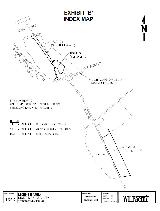
EXHIBIT A
LICENSE AREA
I. Legal Description
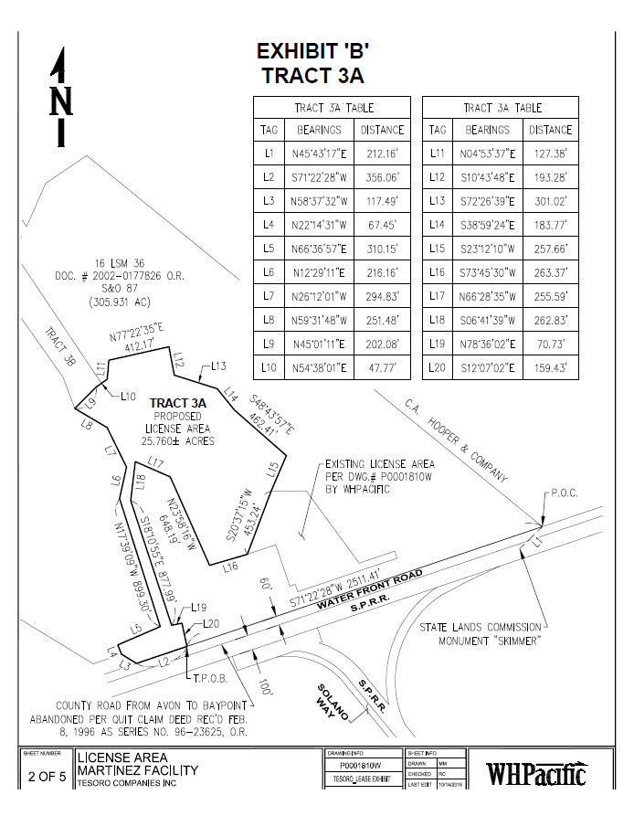
TRACT 3A - LICENSE AREA
A PORTION OF SWAMP AND OVERFLOW SURVEYS No. 87 AS DESCRIBED IN THE PATENT RECORDED NOVEMBER 30, 1875 IN BOOK 2 OF PATENTS, PAGE 310; AND DEED RECORDED MAY 17, 2002 AS DOC. NO. 2002-0177826 O.R. IN THE COUNTY OF CONTRA COSTA, STATE OF CALIFORNIA, DESCRIBED AS FOLLOWS:
COMMENCING AT THE INTERSECTION OF THE NORTHERLY LINE OF THE COUNTY ROAD RUNNING FROM AVON TO BAY POINT AS DESCRIBED IN DEED TO THE COUNTY OF CONTRA COSTA, RECORDED JUNE 18, 1913, IN BOOK 205 OF DEEDS, PAGE 141, WITH THE EASTERLY LINE OF THAT CERTAIN 305 .931 ACRE PARCEL SHOWN ON LICENSE SURVEY MAP RECORDED DECEMBER 31, 1954 IN THE OFFICE OF THE COUNTY RECORDER OF SAID COUNTY IN BOOK 16 OF LICENSE SURVEY MAPS PAGE 36,SAID INTERSECTION SHOWN AS MARKED BY A RAILROAD SPIKE ON SAID LICENSE SURVEY MAP;
THENCE ALONG THE NORTHERLY LINE OF SAID COUNTY ROAD SOUTH 71°22'28" WEST A DISTANCE OF 2511.41 FEET TO THE TRUE POINT OF BEGINNING;
THENCE CONTINUING ALONG SAID NORTHERLY LINE SOUTH 71°22'28" WEST A DISTANCE OF 356.06 FEET TO AN ANGLE POINT IN THE NORTHERLY LINE OF SAID COUNTY ROAD;
THENCE CONTINUING ALONG SAID NORTHERLY LINE, NORTH 58°37'32" WEST, A DISTANCE OF 117.49 FEET TO AN ANGLE POINT IN SAID NORTHERLY LINE;
THENCE LEAVING SAID NORTHERLY LINE OF SAID COUNTY ROAD, NORTH 22°14'31" WEST, A DISTANCE OF 67.45 FEET;
THENCE NORTH 66°36'57" EAST, A DISTANCE OF 310.15 FEET; THENCE NORTH 17°39 '09" WEST, A DISTANCE OF 899.30 FEET; THENCE NORTH 12°29'11" EAST, A DISTANCE OF 216.16 FEET; THENCE NORTH 26°12'01" WEST, A DISTANCE OF 294.83 FEET; THENCE NORTH 59°31'48" WEST, A DISTANCE OF 251.48 FEET; THENCE NORTH 45°01'11" EAST, A DISTANCE OF 202 .08 FEET; THENCE NORTH 54°38'01" EAST, A DISTANCE OF 47.77 FEET; THENCE NORTH 04°53'37" EAST, A DISTANCE OF 127 .38 FEET; THENCE NORTH 77°22'35" EAST, A DISTANCE OF 412.17 FEET; THENCE SOUTH 10°43 '48" EAST, A DISTANCE OF 193.28 FEET; THENCE SOUTH 72°26'39" EAST, A DISTANCE OF 301.02 FEET; THENCE SOUTH 38°59'24" EAST, A DISTANCE OF 183.77 FEET; THENCE SOUTH 48°43'57" EAST, A DISTANCE OF 462.41 FEET; THENCE SOUTH 23°12'10" WEST, A DISTANCE OF 257 .66 FEET;
Exhibit A to License Agreement
THENCE SOUTH 20°37'15" WEST, A DISTANCE OF 453.24 FEET; THENCE SOUTH 73°45'30" EAST, A DISTANCE OF 263 .37 FEET; THENCE NORTH 23°58'16" WEST, A DISTANCE OF 648.19 FEET; THENCE NORTH 66°28'35 " WEST, A DISTANCE OF 255.59 FEET; THENCE SOUTH 06°41'39" WEST, A DISTANCE OF 262 .83 FEET; THENCE SOUTH 18°10'55" EAST,A DISTANCE OF 877 .99 FEET; THENCE NORTH 78°36'02" EAST, A DISTANCE OF 70.73 FEET;
THENCE SOUTH 12°07'02" EAST, A DISTANCE OF 159.43 FEET TO THE TRUE POINT OF BEGINNING . SAID PARCEL CONTAINS 25.760 ACRES, MORE OR LESS.
HEREIN DESCRIBED BEARINGS ARE BASED ON CALIFORNIA COORDINATE SYSTEM {CCS83) (NSRS2007) EPOCH 2011.0 ZONE 3 .
Exhibit A to License Agreement
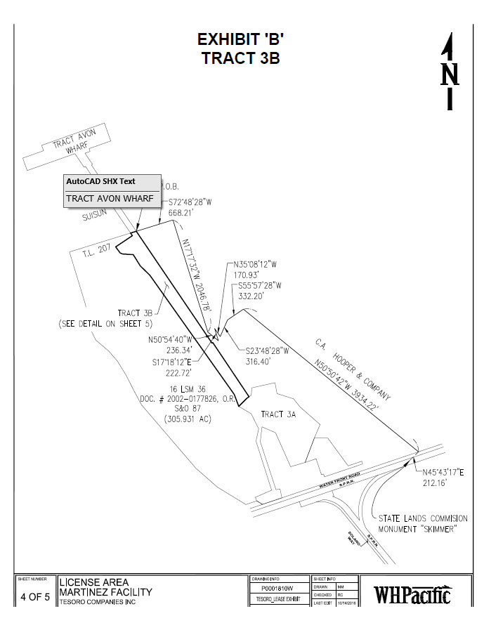
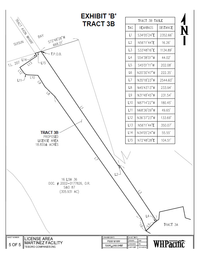
TRACT 3B - LICENSE AREA
A PORTION OF SWAMP AND OVERFLOW SURVEYS No. 87 AS DESCRIBED IN THE PATENT RECORDED NOVEMBER 30, 1875 IN BOOK 2 OF PATENTS, PAGE 310, TOGETHER WITH A PORTION OF TIDE LAND SURVEY No. 207 AS DESCRIBED IN THE PATENT RECORDED NOVEMBER 23, 1901 IN BOOK 4 OF PATENTS, PAGE 402; AND DEED RECORDED MAY 17, 2002 AS DOC. NO. 2002-0177826 O.R. IN THE COUNTY OF CONTRA COSTA, STATE OF CALIFORNIA, DESCRIBED AS FOLLOWS:
COMMENCING AT THE INTERSECTION OF THE NORTHERLY LINE OF THE COUNTY ROAD RUNNING FROM AVON TO BAY POINT AS DESCRIBED IN DEED TO THE COUNTY OF CONTRA COSTA, RECORDED JUNE 18, 1913, IN BOOK 205 OF DEEDS, PAGE 141, WITH THE EASTERLY LINE OF THAT CERTAIN 305.931 ACRE PARCEL SHOWN ON LICENSE SURVEY MAP RECORDED DECEMBER 31,1954 IN THE OFFICE OF THE COUNTY RECORDER OF SAID COUNTY IN BOOK 16 OF LICENSE SURVEY MAPS PAGE 36, SAID INTERSECTION SHOWN AS MARKED BY A RAILROAD SPIKE ON SAID LICENSE SURVEY MAP;
THENCE NORTHWESTERLY ALONG THE BOUNDARY OF SAID 305.931 ACRE PARCEL THE FOLLOWING EIGHT COURSES: NORTH 50°50'42" WEST, 3934.22 FEET;
THENCE SOUTH 55°57'28" WEST, 332.20 FEET;
THENCE SOUTH 23°48'28" WEST, 316.40 FEET;
THENCE NORTH 35°08'12" WEST, 170.93 FEET;
THENCE SOUTH 17°18'12" EAST, 222.72 FEET;
THENCE NORTH 50°54'40" WEST, 236.34 FEET;
THENCE NORTH 17°17'32" WEST, 2046.78 FEET;
THENCE SOUTH 72°48'28" WEST, 668.21 FEET TO THE TRUE POINT OF BEGINNING;
THENCE SOUTHEASTERLY LEAVING SAID BOUNDARY AND THE NORTHERLY LINE OF SAID 305.931 ACRE PARCEL SOUTH 34°05'24" EAST, 2352 .66 FEET;
THENCE NORTH 56°11'44" EAST, 16.26 FEET;
THENCE SOUTH 33°48'16" EAST, 1134.89 FEET;
THENCE SOUTH 54°38'01" WEST, 44.02 FEET; THENCE SOUTH 45°01'11" WEST, 202.08 FEET; THENCE NORTH 20°30'47" WEST, 222.35 FEET;
THENCE NORTH 35°18'23" WEST, 2544.60 FEET; THE CE NORTH 45°43'13" WEST, 233.94 FEET; THENCE NORTH 31°48'45" WEST, 231.54 FEET;
Exhibit A to License Agreement
THENCE NORTH 87°14'22" WEST, 180.45 FEET;
THENCE NORTH 68°36'09" WEST, 49.65 FEET;
THENCE NORTH 36°37'23" WEST, 133.69 FEET; THENCE NORTH S6°11'44" EAST, 3S0.07 FEET;
THENCE NORTH 34°0S'24" WEST, SS.SS FEET TO SAID NORTHERLY LINE OF SAID 30S.391 ACRE PARCEL;
THENCE ALONG SAID NORTHERLY LINE NORTH 72°48'28" EAST, 104.Sl FEET TO THE TRUE POINT OF BEGINNING.
SAID PARCEL CONTAINS 18.8SS ACRES, MORE OR LESS.
HEREIN DESCRIBED BEARINGS ARE BASED ON CALIFORNIA COORDINATE SYSTEM (CCS83) (NSRS2007) EPOCH 2011.0 ZONE 3.
Exhibit A to License Agreement
TRACT 4 - LICENSE AREA
PARCEL 1AND PARCEL 24 OF LAND CONVEYED TO TESORO REFINING AND MARKETING COMPANY AS DESCRIBED IN DEED RECORDED MAY 17, 2002 AS DOC. NO. 2002-0177826 O.R. IN THE COUNTY OF CONTRA COSTA, STATE OF CALIFORNIA.
Exhibit A to License Agreement
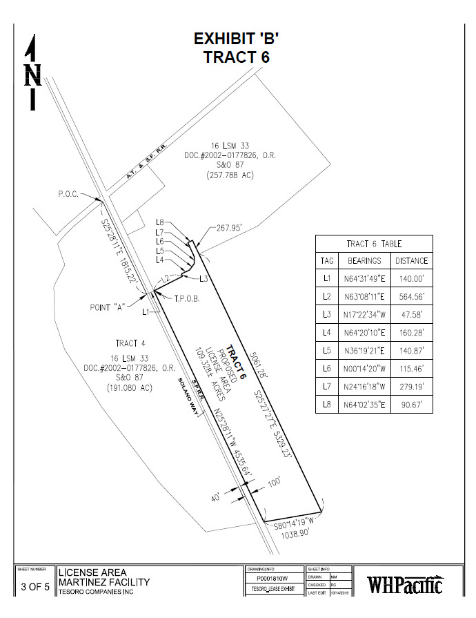
TRACT 6 - LICENSE AREA
A PORTION OF SWAMP AND OVERFLOW SURVEYS No. 87 AS DESCRIBED IN THE PATENT RECORDED NOVEMBER 30, 1875 IN BOOK 2 OF PATENTS, PAGE 310; AND DEED RECORDED MAY 17, 2002 AS DOC. NO. 2002-0177826 O.R. IN THE COUNTY OF CONTRA COSTA, STATE OF CALIFORNIA, DESCRIBED AS FOLLOWS:
COMMENCING AT THE NORTHEASTERLY CORNER OF THAT 191.080 ACRE PARCEL OF LAND AS SHOWN ON LICENSE SURVEY MAP RECORDED DECEMBER 31, 1954 IN THE OFFICE OF THE COUNTY RECORDER OF SAID COUNTY IN BOOK 16 OF LICENSE SURVEY MAPS PAGE 33, SAID INTERSECTION MARKED BY A 2 INCH IRON PIPE ON SAID LICENSE SURVEY MAP;
THENCE SOUTHEASTERLY ALONG THE EASTERLY LINE OF SAID 191.080 ACRE PARCEL SOUTH 25°28'11" EAST A DISTANCE OF 1815.22 FEET TO A POINT;
THENCE LEAVING SAID EASTERLY LINE NORTH 64°31'49" EAST A DISTANCE OF 140.00 FEET TO A POINT ON THE WESTERLY LINE OF THAT 257.788 ACRE PARCEL OF LAND AS SHOWN ON LICENSE SURVEY MAP RECORDED DECEMBER 31,1954 IN THE OFFICE OF THE COUNTY RECORDER OF SAID COUNTY IN BOOK 16 OF LICENSE SURVEY MAPS PAGE 33 AND THE TRUE POINT OF BEGINNING;
THENCE LEAVING SAID WESTERLY LINE NORTH 63°08'11" EAST, A DISTANCE OF 564.56 FEET; THENCE NORTH 17°22'34" WEST, A DISTANCE OF 47.58 FEET;
THENCE NORTH 64°20'10" EAST, A DISTANCE OF 160.28 FEET; THENCE NORTH 36°19'21" EAST, A DISTANCE OF 140.87 FEET; THENCE NORTH 00°14'20" WEST, A DISTANCE OF 115.46 FEET; THENCE NORTH 24°1611811 WEST, A DISTANCE OF 279.19 FEET;
THENCE NORTH 64°02'35" EAST, A DISTANCE OF 90.67 FEET TO A POINT ON A NORTHWESTERLY PROLONGATION OF THE EASTERLY LINE OF SAID 257.788 ACRE PARCEL;
THENCE SOUTHEASTERLY ALONG SAID PROLONGATION SOUTH 25°27'27" EAST, A DISTANCE OF 267.95 FEET TO AN ANGLE POINT IN SAID 257.788 ACRE PARCEL;
THENCE CONTINUING SOUTHEASTERLY ALONG SAID EAST LINE OF SAID 257.788 ACRE PARCEL SOUTH 25°27'27" EAST, A DISTANCE OF 5061.28 FEET TO THE SOUTHEASTERLY CORNER OF SAID 257.788 ACRE PARCEL AS SHOWN ON SAID LICENSE SURVEY MAP;
THENCE ALONG THE SOUTHERLY LINE OF SAID 257.788 ACRE PARCEL SOUTH 80°14'19" EAST, A DISTANCE OF 1038.90 FEET TO THE SOUTHWESTERLY CORNER OF SAID 257.788 ACRE PARCEL;
THENCE ALONG THE WEST LINE OF SAID 257.788 ACRE PARCEL NORTH 25°28'11" EAST, A DISTANCE OF 4535.64 FEET TO THE TRUE POINT OF BEGINNING.
Exhibit A to License Agreement
SAID PARCEL CONTAINS 109.328 ACRES, MORE OR LESS.
HEREIN DESCRIBED BEARINGS ARE BASED ON CALIFORNIA COORDINATE SYSTEM {CCS83) (NSRS2007) EPOCH 2011.0 ZONE 3.
II. Survey Map
(See attached).
Exhibit A to License Agreement