Attached files
| file | filename |
|---|---|
| EXCEL - IDEA: XBRL DOCUMENT - MOHEGAN TRIBAL GAMING AUTHORITY | Financial_Report.xls |
| 10-Q - FORM 10-Q - MOHEGAN TRIBAL GAMING AUTHORITY | a2015331-10q.htm |
| EX-31.2 - EXHIBIT 31.2 - MOHEGAN TRIBAL GAMING AUTHORITY | a2015331ex312.htm |
| EX-32.1 - EXHIBIT 32.1 - MOHEGAN TRIBAL GAMING AUTHORITY | a2015331ex321.htm |
| EX-32.2 - EXHIBIT 32.2 - MOHEGAN TRIBAL GAMING AUTHORITY | a2015331ex322.htm |
| EX-31.1 - EXHIBIT 31.1 - MOHEGAN TRIBAL GAMING AUTHORITY | a2015331ex311.htm |
Exhibit 10.2
FOURTH AMENDMENT TO LAND LEASE
This Fourth Amendment to Land Lease (“Fourth Amendment”) is entered into as of this 27th day of February, 2015, between THE MOHEGAN TRIBE OF INDIANS OF CONNECTICUT, a federally recognized Indian tribe (as lessor or landlord under the Land Lease referred to below, being hereinafter referred to as the “Tribe”), and the MOHEGAN TRIBAL GAMING AUTHORITY, an instrumentality of the Tribe (as lessee or tenant under such Land Lease, being hereinafter referred to as the “Authority”).
WHEREAS, the Tribe and the Authority are parties to that certain Land Lease dated September 29, 1995, as amended by Amendment of Land Lease dated September 29, 1995, as further amended by Amendment to Land Lease dated February 18, 1999, and as further amended by Amendment to Land Lease dated March 6, 2007 (the Land Lease, as so amended, the “Land Lease”); and
WHEREAS, the Tribe and the Authority desire to further amend the Land Lease for the purpose of updating and replacing (i) the description of the Premises as set forth in Exhibit A of the Land Lease to exclude therefrom a certain parcel known as the Hotel Lease Area and (ii) the Survey Plan depicting the Premises as set forth in Exhibit B of the Land Lease.
NOW, THEREFORE, in consideration of the foregoing and the agreements of the parties hereinafter set forth, the parties hereto hereby agree as follows:
1. The Land Lease is hereby amended by deleting the Legal Description of the Property located in Exhibit A thereto, and by inserting in lieu thereof the Legal Description of the Property attached hereto as Exhibit A.
2. The Land Lease is hereby amended by deleting the Survey Plan located at Exhibit B thereto, and by inserting in lieu thereof the General Location Survey attached hereto as Exhibit B.
3. Except as modified hereby, the Land Lease shall remain in full force and effect.
[SPACE INTENTIONALLY LEFT BLANK]
1
IN WITNESS WHEREOF, the parties hereto have executed this Fourth Amendment on the year and day first above written.
WITNESSES: | THE MOHEGAN TRIBE OF INDIANS OF CONNECTICUT | ||
/S/ HELGA M. WOODS | By: | /S/ KEVIN P. BROWN | |
Helga M. Woods | Name: Kevin P. Brown | ||
Title: Chairman, Tribal Council | |||
/S/ DONNA R. GRIFFIN | |||
Donna R. Griffin | |||
MOHEGAN TRIBAL GAMING AUTHORITY | |||
/S/ SCOTT WELLS | By: | /S/ MITCHELL G. ETESS | |
Scott Wells | Name: Mitchell G. Etess | ||
Title: Chief Executive Officer | |||
/S/ DENISE A. RUBINO | |||
Denise A. Rubino | |||
STATE OF CONNECTICUT )
) ss: Uncasville
COUNTY OF NEW LONDON)
On this the 27th day of February, 2015, before me, the undersigned officer, personally appeared KEVIN P. BROWN, Chairman of the Tribal Council of THE MOHEGAN TRIBE OF INDIANS OF CONNECTICUT, a federally recognized Indian tribe, the duly authorized signer and sealer of the foregoing instrument who acknowledged that he executed the foregoing instrument for the purposes and in the capacity herein contained as and for his free act and deed and the free act and deed of the Tribe.
/S/ DONNA R. GRIFFIN
Commissioner of the Superior Court
Notary Public
My Commission Expires: 10/31/2017
2
STATE OF CONNECTICUT )
) ss: Uncasville
COUNTY OF NEW LONDON )
On this the 26th day of February, 2015, before me, the undersigned officer, personally appeared MITCHELL G. ETESS, the Chief Executive Officer of the MOHEGAN TRIBAL GAMING AUTHORITY, the duly authorized signer and sealer of the foregoing instrument who acknowledged that he executed the foregoing instrument for the purposes and in the capacity herein contained as and for his free act and deed and the free act and deed of the Authority.
/S/ DENISE A. RUBINO
Commissioner of the Superior Court
Notary Public
My Commission Expires: 5/31/2015
3
The undersigned parties agree that the foregoing agreement is in compliance with 25 U.S.C. §415 and 25 C.F.R. §162:
The Mohegan Tribe of Indians of Connecticut | |||
Date: 2/27/2015 | By: | /S/ KEVIN P. BROWN | |
Name: Kevin P. Brown | |||
Title: Chairman, Tribal Council | |||
Mohegan Tribal Gaming Authority | |||
Date: 2/26/2015 | By: | /S/ MITCHELL G. ETESS | |
Name: Mitchell G. Etess | |||
Title: Chief Executive Officer | |||
Approved pursuant to 25 U.S.C. §415 and 25 C.F.R. §162, and delegated authority of 209 DM 8, 230 DM 1, and 3 IAM 4. | |||
United States Department of Interior Bureau of Indian Affairs | |||
Date: 3/3/2015 | By: | /S/ SCOTT C. MENEELY | |
Name: Scott C. Meneely | |||
Title: Acting Regional Director | |||
STATE OF TENNESSEE )
) ss.
COUNTY OF DAVIDSON )
PERSONALLY APPEARED BEFORE ME, the undersigned Authority in and for said
County and State, on the 3rd day of March, 2015, within my jurisdiction, the within named Scott C. Meneely, who acknowledged that he is the Acting Regional Director of the Bureau of Indian Affairs, and that in said representative capacity, he/she executed the foregoing instrument, after having been duly authorized so to do.
4
/S/ JOHN W. SMITH
Notary Public
My Commission Expires: 3/6/2018
5
EXHIBIT A
Legal Description of the Property
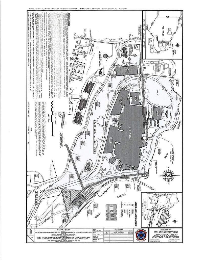
A certain tract or parcel of land, together with the buildings and all other improvements thereon, situated on the southeasterly side of Sandy Desert Road, easterly of Connecticut Route No. 32, northeasterly of Crow Hill Road, westerly of Thames River and southerly of Trading Cove in the Town of Montville, County of New London and State of Connecticut and being more particularly shown and delineated on a certain map or plan entitled “SURVEY PLAN LAND OF UNITED STATES OF AMERICA IN TRUST FOR THE MOHEGAN TRIBE OF INDIANS OF CONNECTICUT TO BE LEASED TO MOHEGAN TRIBAL GAMING AUTHORITY PREPARED FOR THE MOHEGAN TRIBE OF INDIANS OF CONNECTICUT Located At Sandy Desert Road, Crow Hill Road and Mohegan Sun Boulevard Montville (Uncasville), Connecticut Date: January 2, 2007 Scale: 1” = 200’ Project No: 200614 Sheet 1 of 1” Prepared By The Mohegan Tribe CAD Document Control Department, which premises are more particularly bounded and described as follows:
Beginning at a point in the southeasterly line of land now or formerly of The Mohegan Tribe Of Indians Of Connecticut (southeasterly street line of Sandy Desert Road) at a northwesterly corner of the herein-described tract and on the dividing line between the herein-described tract and other land of The United States Of America In Trust For The Mohegan Tribe Of Indians Of Connecticut;
Thence running South 02° 41’ 50” East for a distance of 322.32 feet to a point;
Thence running North 85° 24’ 27” East for a distance of 304.00 feet to a point;
Thence running South 04° 35’ 33” East for a distance of 254.69 feet to a point;
Thence running North 85° 28’ 43” West for a distance of 52.08 feet to a point;
Thence running South 06° 35’ 16” East for a distance of 190.41 feet to a point;
Thence running South 52° 42’ 03” East for a distance of 63.49 feet to a point;
Thence running in a general southeasterly direction along the arc of a curve to the left with a radius of 400.00 feet, a central angle of 17° 33’ 57” for a distance of 122.63 feet to a point;
Thence running South 70° 16’ 00” East for a distance of 141.88 feet to a point;
Thence running in a general southeasterly direction along the arc of a curve to the right with a radius of 1240.00 feet, a central angle of 17° 06’ 42” for a distance of 370.34 feet to a point;
Thence running South 53° 09’ 17” East for a distance of 184.55 feet to a point;
Thence running in a general southeasterly direction along the arc of a curve to the left with a radius of 1150.00 feet, a central angle of 23° 37’ 52” for a distance of 474.31 feet to a point;
Thence running South 76° 47’ 09” East for a distance of 402.28 feet to a point;
Thence running in a general southeasterly direction along the arc of a curve to the right with a radius of 649.90 feet, a central angle of 30° 29’ 57” for a distance of 345.95 feet to a point;
Thence running South 46° 17’ 12” East for a distance of 137.84 feet to a point;
Thence running in a general southeasterly direction along the arc of a curve to the left with a radius of 350.09 feet, a central angle of 20° 44’ 48” for a distance of 126.77 feet to a point;
Thence running South 67° 02’ 00” East for a distance of 358.04 feet to a point;
Thence running in a general southeasterly direction along the arc of a curve to the left with a radius of 850.00 feet, a central angle of 11° 27’ 44” for a distance of 170.05 feet to a point;
Thence running South 78° 29’ 44” East for a distance of 290.02 feet to a point;
Thence running in a general southeasterly direction along the arc of a curve to the right with a radius of 649.90 feet, a central angle of 45° 11’ 01” for a distance of 512.51 feet to a point;
Thence running South 33° 18’ 27” East for a distance of 546.87 feet to a point;
Thence running in a general southeasterly direction along the arc of a curve to the left with a radius of 624.21 feet, a central angle of 07° 41’ 21” for a distance of 83.77 feet to the southerly corner of the herein described tract;
Thence running North 17° 46’ 50” West for a distance of 86.72 feet to a point;
Thence running North 15° 59’ 54” West for a distance of 69.57 feet to a point;
Thence running North 13° 09’ 20” West for a distance of 241.49 feet to a point;
Thence running North 08° 51’ 10” West for a distance of 99.13 feet to a point;
Thence running North 13° 11’ 22” West for a distance of 44.72 feet to a point;
Thence running North 06° 55’ 31” West for a distance of 44.45 feet to a point, the last twenty seven courses being bounded by other land of The United States Of America In Trust For The Mohegan Tribe Of Indians Of Connecticut;
Thence running North 73° 35’ 41” East for a distance of 71.66 feet to a point, the last course being bounded southeasterly in part by other land of The United States Of America In Trust For The Mohegan Tribe Of Indians Of Connecticut and in part by land now or formerly of MTIC Acquisitions, LLC;
Thence running North 73° 57’ 46” East for a distance of 48.45 feet to a concrete monument recovered, the last course being bounded southeasterly by land now or formerly of MTIC Acquisitions, LLC;
Thence running North 75° 05’ 39’ East for a distance of 190.94 feet, bounded southeasterly in part by land now or formerly of MTIC Acquisitions, LLC and in part by land now or formerly of Southeastern Connecticut Regional Resource Recovery Authority to a concrete monument recovered;
Thence running North 73° 18’ 39” East for a distance of 166.10 feet to an angle point;
Thence running North 75° 48’ 39” East for a distance of 241.15 feet to a point at Connecticut Grid Coordinates North 738813.29, East 1183036.66;
Thence continuing North 75° 48’ 39” East for a distance of 242.59 feet to the southeasterly corner of the herein described tract, said point lying in the southwesterly line of land now or formerly of Central Vermont Railway, Inc., the last three courses being bounded southeasterly by land now or formerly of Southeastern Connecticut Regional Resource Recovery Authority;
Thence running North 44° 36’ 07” West for a distance of 550.97 feet to a point;
Thence running in a general northwesterly direction along the arc of a curve to the left with a radius of 3100.09 feet, a central angle of 02° 45’ 25” for a distance of 149.17 feet to a point;
Thence running in a general northwesterly direction along the arc of a curve to the left with a radius of 3100.00 feet, a central angel of 04° 34’ 39” for a distance of 247.66 feet to a point;
Thence running North 51° 56’ 11” West for a distance of 150.00 feet to a point;
Thence running in a general northwesterly direction along the arc of a curve to the right with a radius of 1132.75 feet, a central angle of 37° 19’ 02” for a distance of 737.77 feet to a point;
Thence running in a general northerly direction along the arc of a curve to the right with a radius of 883.00 feet, a central angle of 38° 49’ 37” for a distance of 598.37 feet to a concrete
monument recovered, the last six courses being bounded northeasterly and easterly by land now or formerly of Central Vermont Railway, Inc.;
Thence running North 45° 14’ 00” West for a distance of 35 feet, more or less, bounded northeasterly by land now or formerly of Central Vermont Railway, Inc. to a monument set in the tidal high water mark of Trading Cove;
Thence running in a general westerly direction along the tidal high water mark of Trading Cove for a distance of 3743 feet, more or less, to a point which is located North 06° 33’ 05” East 77 feet, more or less, from a rebar recovered at Connecticut Grid Coordinates North 741768.53, East 1179180.50;
Thence running South 06° 33’ 05” West for a distance of 77 feet, more or less, to a rebar recovered;
Thence running South 06° 33’ 05” West for a distance of 547.80 feet to an iron pipe recovered;
Thence running South 06° 34’ 37” West for a distance of 275.26 feet to a concrete monument recovered;
Thence running South 07° 16’ 42” West for a distance of 52.35 feet to a point;
Thence running South 88° 08’ 28” West for a distance of 246.94 feet to a point;
Thence running South 89° 56’ 24” West for a distance of 294.38 feet to the point and place of beginning, the last six courses being bounded by land now or formerly of The Mohegan Tribe Of Indians Of Connecticut.
Said Lease Area Containing 185 acres, more or less.
Together with the non-exclusive right to pass and repass over that certain roadway known as Sandy Desert Road (which roadway leads from the westerly portion of the herein described property to Conn. Route #32 as shown on said map), as the same now exists or may hereafter be relocated, expanded or extended, including any extension thereof from the northwesterly portion of the herein described property to Conn. Route #32; and
Together with the non-exclusive right to pass and repass over that certain roadway known as Mohegan Sun Boulevard, as the same now exists or may hereafter be relocated, expanded or extended, which roadway leads from the southeasterly portion of the herein described property to Conn. Route #2A as shown on said map; and
Together with all rights, easements, hereditaments and appurtenances thereto appertaining and all right, title and interest, if any, in and to strips and gores adjoining said premises and in and to the land lying in the bed of any street or streets adjoining said premises.
EXCEPTING THEREFROM that certain piece or parcel of land together with the improvements thereon located, shown as:
That certain Hotel Lease Area, located at 1 Mohegan Sun Boulevard, in the Town of Montville, County of New London and State of Connecticut, and being more particularly bounded and described as follows:
Beginning at the northwesterly corner of the herein described Hotel Lease Area, said point having coordinates of North 741,349.56 feet, East 1,180,631.40 feet, as more particularly shown on the herein referenced survey plan;
Thence running S63° 51' 11"E by and along the edge of said Hotel Lease Area, for a distance of 46.84 feet to a point;
Thence running N06° 10' 48"E by and along the edge of said Hotel Lease Area, for a distance of 12.54 feet to a point;
Thence running S63° 42' 51"E by and along the edge of said Hotel Lease Area, for a distance of 20.58 feet to a point;
Thence running S66° 26' 35"E by and along the edge of said Hotel Lease Area, for a distance of 62.37 feet to a point;
Thence running S36° 06' 28"E by and along the edge of said Hotel Lease Area, for a distance of 40.95 feet to a point;
Thence running in a general southeasterly direction along the arc of a curve to the right having a central angle of 09º54’45”, a radius of 95.74’, a chord bearing of S66° 55' 39"E and a chord length of 16.54 feet, by and along the edge of said Hotel Lease Area, for a distance of 16.56 feet to a point;
Thence running S64° 30' 28"E by and along the edge of said Hotel Lease Area, for a distance of 33.30 feet to a point;
Thence running in a general southeasterly direction along the arc of a curve to the left having a central angle of 18º01’22” and a radius of 95.00’, a chord bearing of S76° 02' 54"E and a chord length of 29.76 feet, by and along the edge of said Hotel Lease Area, for a distance of 29.88 feet to a point;
Thence running S85° 03' 35"E by and along the edge of said Hotel Lease Area, for a distance of 11.66 feet to a point;
Thence running in a general southeasterly direction along the arc of a curve to the right having a central angle of 52º22’26” and a radius of 45.00’, a chord bearing of S58° 52' 23"E and a chord length of 39.72 feet, by and along the edge of said Hotel Lease Area, for a distance of 41.13 feet to a point;
Thence running in a general southeasterly direction along the arc of a curve to the right having a central angle of 39º05’07” and a radius of 68.00’, a chord bearing of S13° 08' 36"E and a chord length of 45.49 feet, by and along the edge of said Hotel Lease Area, for a distance of 46.39 feet to a point;
Thence running in a general southerly direction along the arc of a curve to the left having a central angle of 18º17’17” and a radius of 95.00’, a chord bearing of S02° 44' 41"E and a chord length of 30.19 feet, by and along the edge of said Hotel Lease Area, for a distance of 30.32 feet to a point;
Thence running S24° 22' 59"E by and along the edge of said Hotel Lease Area, for a distance of 26.59 feet to the southeasterly corner of the herein described lease area;
Thence running in a general northwesterly direction along the arc of a curve to the left having a central angle of 105º50’47” and a radius of 10.00’, a chord bearing of N83° 51' 50"W and a chord length of 15.96 feet, by and along the edge of said Hotel Lease Area, for a distance of 18.47 feet to a point;
Thence running in a general westerly direction along the arc of a curve to the right having a central angle of 81º53’24” and a radius of 88.00’, a chord bearing of S84° 09' 28"W and a chord
length of 115.34 feet, by and along the edge of said Hotel Lease Area, for a distance of 125.77 feet to a point;
Thence running S56° 38' 55"W by and along the edge of said Hotel Lease Area, for a distance of 80.16 feet to a point having coordinates of North 741,071.96 feet, East 1,180,719.52 feet;
Thence running N53° 49' 12"W by and along the edge of said Hotel Lease Area, for a distance of 135.67 feet to a point having coordinates of North 741,152.05 feet, East 1,180,610.01 feet;
Thence running N06° 10' 48"E by and along the edge of said Hotel Lease Area, for a distance of 198.67 feet to the point and place of beginning;
Said Hotel Lease Area being bounded on all sides by other land of the United States of America In Trust For The Mohegan Tribe of Indians of Connecticut (Leased to The Mohegan Tribal Gaming Authority) (“Tribe’s Other Land”);
Said Hotel Lease Area contains 1.21 acres, more or less (52,764 square feet, more or less), and is more particularly shown as “HOTEL LEASE AREA” on a survey plan entitled: “Mohegan Hotel Lease Area Mohegan Tribe of Indians of Connecticut Mohegan Sun Resort Casino” 1 Mohegan Sun Boulevard Uncasville (Montville), Connecticut” Date: 01/28/2015 Scale: 1’=20’, Project # 2014-051. Prepared By The Mohegan Tribe, CAD/GIS Document Control Department.
Said Hotel Lease Area being leased (1) together with the non-exclusive right to use on, over and across the Tribe’s Other Land the public access roads (including Mohegan Sun Boulevard and Cove Road) and public parking areas in common with others (and subject to the rules and regulatory requirements of the Tribe or its designee) on the Tribe’s Other Land to serve the HOTEL LEASE AREA, together with the right to construct, install, maintain, repair, replace, use and operate the “PROPOSED VALET DRIVEWAY”, the “PROPOSED HOTEL LOADING DOCK”, and the “PROPOSED HOTEL CONNECTOR TO WINTER ENTRANCE” all as shown on the aforesaid survey plan, provided, however, that such driveway, loading dock and connector shall be subject to relocation at any time and from time to time by the Tribe or its designee as the Tribe may require, so long as such relocation does not unreasonably interfere with the use of the HOTEL LEASE AREA for its intended purposes; and (2) together with the non-exclusive right to use and operate in, on, over and across the Tribe’s Other Land the utilities lines serving the Tribe’s Other Land to serve the HOTEL LEASE AREA, together with the non-exclusive right to construct, install, maintain, repair, replace, use and operate, in, on , over and across the Tribe’s Other Land such electric power, water, sanitary and storm sewer, and other utilities serving the HOTEL LEASE AREA, all as shown on the plans and specifications for the construction of the Hotel delivered to and approved by the Tribe and subject to the regulatory requirements of the Tribe, provided, however, that such utilities shall be subject to relocation at any time and from time to time by the Tribe or its designee as the Tribe may require, so long as such relocation does not unreasonably interfere with the use of the HOTEL LEASE AREA for its intended purposes.
EXHIBIT B
General Location Survey - Attached