Attached files
| file | filename |
|---|---|
| 8-K - MAINBODY - FORCE MINERALS CORP | mainbody.htm |
| EX-10.1 - EXHIBIT 10.1 - FORCE MINERALS CORP | ex10_1.htm |
| EX-99.2 - EXHIBIT 99.2 - FORCE MINERALS CORP | ex99_2.htm |
NI 43-101 Technical Report
on the Zoro 1 Property, Snow
Lake Area, Manitoba (NTS 63J13SE)
|
SEPTEMBER 2009
|
||
|
Prepared
By
|
Mark Fedikow, Ph.D., P.Eng.,
P.Geo., C.P.G.
Mount Morgan Resources Ltd.
50 Dobals Road North
P.O. Box 629
Lac du Bonnet, Manitoba
R0E 1A0 Canada
|
Date: September 4th, 2009
|
1
TABLE OF CONTENTS
|
1.0
|
SUMMARY
|
3
|
|
2.0
|
INTRODUCTION AND TERMS OF REFERENCE
|
5
|
|
2.1 TERMS OF REFERENCE
|
5
|
|
|
3.0
|
RELIANCE ON OTHER EXPERTS
|
7
|
|
4.0
|
PROPERTY LOCATION AND DESCRIPTION
|
8
|
|
4.1 PROPERTY LOCATION
|
8
|
|
|
4.2 PROPERTY DESCRIPTION
|
10
|
|
|
5.0
|
ACCESSIBILITY, CLIMATE, LOCAL RESOURCES, INFRASTRUCTURE AND PHYSIOGRAPHY
|
11
|
|
5.1 TOPOGRAPHY, ELEVATION AND VEGETATION
|
11
|
|
|
5.2 ACCESSIBILITY
|
11
|
|
|
5.3 LOCAL RESOURCES
|
12
|
|
|
5.4 CLIMATE
|
12
|
|
|
6.0
|
HISTORY
|
14
|
|
7.0
|
GEOLOGICAL SETTING
|
17
|
|
7.1 BEDROCK GEOLOGY-INTRODUCTION
|
17
|
|
|
7.2 GEOLOGICAL EVOLUTION AND COMPONENTS OF THE FLIN FLON-SNOW LAKE GREENSTONE BELT
|
20
|
|
|
7.3 GENERAL AND DETAILED GEOLOGY
|
24
|
|
|
7.4 METALLOGENY
|
28
|
|
|
7.5 SURFICIAL GEOLOGY
|
29
|
|
|
7.6 GEOPHYSICAL CHARACTERISTICS OF THE ZORO 1 PROPERTY
|
30
|
|
|
8.0
|
DEPOSIT TYPES
|
33
|
|
9.0
|
MINERALIZATION
|
34
|
|
9.1 OTHER MINERALIZATION
|
37
|
|
|
10.0
|
EXPLORATION
|
38
|
|
11.0
|
DRILLING
|
39
|
|
12.0
|
SAMPLING METHOD AND APPROACH
|
45
|
|
13.0
|
SAMPLE PREPARATION, ANALYSES AND SECURITY
|
47
|
|
14.0
|
DATA VERIFICATION
|
48
|
|
15.0
|
ADJACENT PROPERTIES
|
49
|
2
|
16.0
|
MINERAL PROCESSING AND METALLURGICAL TESTING
|
50
|
|
17.0
|
MINERAL RESOURCE AND MINERAL RESERVE ESTIMATES
|
51
|
|
18.0
|
OTHER RELEVANT DATA AND INFORMATION
|
53
|
|
19.0
|
MARKETS
|
54
|
|
20.0
|
INTERPRETATION AND CONCLUSIONS
|
57
|
|
21.0
|
RECOMMENDATIONS
|
58
|
|
21.1 EXPLORATION RECOMMENDATIONS
|
58
|
|
|
22.0
|
REFERENCES
|
60
|
|
23.0
|
CERTIFICATE OF QUALIFIED PERSON
|
67
|
3
LIST OF TABLES
|
Table 4.1: Zoro 1 claim information.
|
10
|
|
Table 5.1: Monthly climate averages for Flin Flon, including temperature highs, lows and precipitation values. Flin Flon climate data from the airport (54⁰41'N, 101⁰41'W at elevation 303.9 m) (source: Environment Canada website).
|
13
|
|
Table 8.1: Pegmatite classification abbreviated after Rudenko et al. (1975) showing the possible field of the Zoro 1 spodumene-lepidolite pegmatite (from Cerny, 1982).
|
33
|
|
Table 9.1: The compositional characteristics of selected minerals from the Zoro 1 pegmatite (Cerny, 1981).
|
35
|
|
Table 9.2: Summary of the pulp characteristics of the Lithium-bearing dykes on the Zoro 1 property
|
36
|
|
Table 9.3: Summary of gold assay results from drill core at the Principal or westernmost dyke. Mineralization consisted of fine-grained, disseminated pyrrhotite, chalcopyrite and arsenopyrite
|
37
|
|
Table 11.1: Summary of drill core (n=78) information from Zoro 1 pegmatite property.
|
42
|
|
Table 17.1: Parameters for the calculation of grade and tonnage at the westernmost lithium-bearing pegmatite dyke, Zoro 1 property.
|
51
|
|
Table 17.2: Combined calculations used to derive grade and tonnage, Zoro 1 property.
|
51
|
|
Table 21.1: Recommended exploration program for Zoro 1 property.
|
59
|
4
LIST OF FIGURES
|
Figure 4.1: Location of Zoro 1 property, east shore of Wekusko Lake.
|
9
|
|
Figure 7.1: Location map after Hoffman (1989) illustrating the position of the Flin Flon-Snow Lake Belt in relation to the Precambrian geology of North America (A) and central Canada (B). The latter illustrates the components of the dominantly juvenile core to the Trans-Hudson Orogen in relation to the bordering Archean terranes, middle Proterozoic Athabasca Basin and overlying Phanerozoic strata of the Western Canada Sedimentary Basin. FFB: Flin Flon Belt; GD: Glennie Domain; HLB: Hanson Lake Block: LL-LT: Lynn Lake-LaRonge Belt; KD: Kisseynew Domain; RD: Rottenstone Domain; RL: Rusty Lake Belt; TB: Thompson Belt; TB: Tabernor Fault Zone; WB: Wathaman-Chipewayan Batholith; WD: Wollaston Domain. Modified from Lucas et al. (1996) from the original by Hoffman (1989). Dashed box represents area shown in more detail in Figure 7.2.
|
19
|
|
Figure 7.2: Map of the Flin Flon-Snow Lake Belt, illustrating the tectonicstratigraphic assemblages, the location of the various accretionary assemblages, and major mineral deposits. B: Birch Lake assemblage; FMI: Fourmile Island assemblage; ML: Morton Lake fault zone; S: Sandy Bay assemblage; TB: Tabernor Fault Zone; SW: Sturgeon-Weir fault zone. Modified from Zwanzig (1999) and Lucas et al. (1996).
|
20
|
|
Figure 7.3: General geology in vicinity of the Zoro 1 lithium pegmatite property.
|
25
|
|
Figure 7.4: Detailed geology at the Zoro 1 lithium pegmatite property.
|
26
|
|
Figure 7.5: Overgrown trench at the Zoro 1 lithium pegmatite property
|
27
|
|
Figure 7.6: Overgrown and slumped trench at the Zoro 1 lithium pegmatite property.
|
28
|
|
Figure 7.7: Surficial geology of the Zoro 1 property.
|
30
|
|
Figure 7.8: Regional airborne Total Magnetic Intensity survey results of the Zoro 1 property/Wekusko Lake area.
|
31
|
|
Figure 7.9: Regional airborne Vertical Gradient for the Zoro 1 property/Wekusko Lake area.
|
32
|
|
Figure 9.1: Coarse-grained bladed spodumene, muck sample, Zoro 1 property
|
35
|
|
Figure 11.1: Drill core from historic diamond drill programs, Zoro 1 property.
|
40
|
|
Figure 11.2: Drill stem from historic drill programs, Zoro 1 property.
|
41
|
5
1.0 SUMMARY
An evaluation of data from the Zoro 1 lithium pegmatite (also referred to as the Sherman property and the Bil Group Pegmatite) was undertaken at the request of Mr. Dalton Dupasquier. The objectives of this NI 43-101 report were to summarize the geology, review the historic ore reserves, and economic potential of the spodumene-bearing dykes delineated on the property and their surrounding geological environment. This report follows the format of form 43-101F1.
The Zoro 1 property is located near the east shore of Wekusko Lake in west-central Manitoba, approximately 249 km southeast of Thompson and 571 km north-northeast of Winnipeg. The Zoro 1 pegmatite dykes were initially staked in 1953. The claim is held in the name of Dalton Bruce Dupasquier and is in good standing.
Data that forms the basis for this report is derived from logs and assay results from the information in cancelled assessment files, Manitoba Science, Technology Energy and Mines government reports and from field observations by the author.
The Zoro 1 property is situated in NTS area 63J13SE in the east end of the Proterozoic Flin Flon-Snow Lake greenstone belt. The property is underlain by Ocean Floor mafic volcanic rocks and related intrusions and to a lesser extent Missi Group clastic quartzofeldspathic sedimentary rocks. The property is situated in a magnetically “quiet” area surrounded on all sides by large, intense magnetic highs. The area is crosscut by northeast and near-east-trending structures including the Berry Creek fault that extends along Crowduck Bay just north of Wekusko Lake.
The Zoro 1 pegmatite dykes strike northwest and dip steeply northeast. These dykes occupy a series of northwest fractures within a package of mafic volcanic rocks that are predominantly massive flows. Due to mantling of the general area of the pegmatites by silt and clay-rich glaciolacustrine sediment, outcrop of the pegmatites are not abundant and tend to be only partly exposed.
The seven Zoro 1 pegmatites were exposed by a series of seven main trenches and a total of 78 diamond drill holes during historic exploration. The seven zoned pegmatite dykes intrude Proterozoic Amisk Group volcanic and volcaniclastic rocks in a 2 km zone trending
6
approximately 55° northwest, strike north to northwest and dip vertically. Individual pegmatite dykes have lengths of approximately 244 m. The main, most westerly dyke outcrops along the west side of a ridge, 4.5 to 6 m high, and intrudes siliceous metasedimentary rocks and amphibolite. It is 27 m (90 ft.) wide and is exposed in 16 cross-trenches for a length of 183 m.
The outer zones of the pegmatite dykes contain pink aplite and coarse feldspar, muscovite, tourmaline, and beryl. Spodumene, quartz, cleavelandite, and tourmaline form core zones with interstitial coarse feldspar. Spodumene is usually coarse-grained and is sometimes altered. It is most prevalent in the central 9 m (30 ft.) of the main dyke. In this dyke, spodumene crystals (up to 35 cm long) occur either in clusters, over widths of 6 m or more, or associated with coarse tourmaline and perthite megacrysts; some spodumene crystals show a preferred orientation of 45° to 55°. One of two parallel dykes south of the main outcrop, is 5 m wide, and contains spodumene crystals in pods (up to 33 cm across). In other dykes, coarse grained spodumene is abundant in lenticular bands and fine-grained spodumene is distributed through aplitic patches. Beryl occurs as white, anhedral to subhedral crystals less than 1 inch (2.5 cm) in diameter in three of the seven dykes. Columbite-tantalite and sparse minute grains of pyrite and chalcopyrite were found in thin sections and gold mineralization is present in quartz-rich veins and laminae in association with arsenopyrite, pyrrhotite and chalcopyrite.
An historic reserve estimate for Li2O has been calculated on limited drilling on a single dyke on the Zoro 1 property. Drill indicated spodumene reserves coupled with data from trenching have been calculated with a total undiluted tonnage given as 1,727,550 at 0.945% Li2O.
The Zoro 1 property hosts multiple rare metal spodumene pegmatite dykes. The main mass of spodumene-bearing zones exposed in seven main trenches has not been fully delineated and a recommended exploration program will assess the geological characteristics of the dykes on the property. Trench rehabilitation, new sampling from the trenches and diamond drilling and a thorough assay/analytical approach accompanied by a quality assurance and quality control program is recommended. Rare and precious metal contents in the pegmatite, not considered in the historic exploration and development program, can also be assessed in this manner.
7
2.0 INTRODUCTION AND TERMS OF REFERENCE
The Zoro 1 property is located near the east shore of Wekusko Lake in west-central Manitoba, approximately 25 km east of the mining centre of Snow Lake, 249 km southeast of Thompson and 571 km north-northeast of Winnipeg.
An evaluation of historic data from the Zoro 1 lithium pegmatite was undertaken for Dalton Duspaquier. The objectives of this report were to summarize the geology, historic ore reserves, and economic potential of spodumene-bearing dykes delineated on the property. Data utilized in this report includes information from the Manitoba Cancelled Assessment files, and data summarized from non-confidential assessment reports within the files of Manitoba Science, Technology, Energy and Mines. The report will provide the geological framework for the property and guide further exploration including diamond drilling and exploration in the immediate area of the Zoro 1 pegmatite dykes for repetitions of this style of mineralization.
The author has visited the property on two separate occasions. The first was to undertake a mineral deposit description for the Manitoba Geological Survey as part of a program to document mineral deposits and occurrences in the Province. This field visit was made in 1986 and results published in Fedikow et. al. (1986) and expanded in Fedikow et al. (1993). A subsequent visit was made in August of 2009 to assess the availability of outcrop for geological mapping, to examine the property area for exposures of the pegmatite dykes, to review the immediate area for historic and new diamond drill hole collars and to assess the general area for considerations relating to possible production decisions.
2.1 TERMS OF REFERENCE
Mr. Dalton Dupasquier commissioned Mount Morgan Resources Ltd. to provide a NI 43-101 complaint technical report of the Zoro 1 property. The report is to provide an estimation of the mineral resource potential for the project based on the current data available. The report incorporates all available outcrop data and drill hole data on the property. This report follows the format defined by Form 43-101F1.
8
3.0 RELIANCE ON OTHER EXPERTS
Mark Fedikow Ph.D. P.Eng. P.Geo. C.P.G. (Mount Morgan Resources Ltd.) is an independent mineral exploration consultant and holds no interest in the Zoro 1 property. The author will be paid a fee for the preparation of this report according to normal consulting practice. The author has in part, relied on other experts for issues relevant to this report and makes no warranty to the accuracy or validity of the compiled data presented herein and is assuming no liability for claims, losses or damages arising out of the use of this data.
The author has relied on the contents of various assessment reports that when produced were considered to meet industry standards for this time period, Manitoba government compilations, and geological literature in the public domain to describe past exploration work on the property. These reports are cited where appropriate in the items below. References to mineral dispositions, namely hectares and notable dates, are taken from Manitoba Government mineral title descriptions.
At the date of this report, interpretations, opinions and data presentations contained within the report are based on the following: data and information available to the author at the time of preparation of this report; reports and opinions supplied by sources cited as references; and assumptions and qualifications as noted in this report. All descriptions of mineral resources cited in this report are presented as historical resource estimates and use historical terminology of these estimates. These citations are given to provide an historical frame of reference. Although the resource estimations quoted in the text are believed to be reliable, they were calculated prior to the implementation of National Instrument 43-101. The author has not carried out work to classify these historical estimates under current mineral resource or mineral reserve terminology. The historical estimates are not meant to be interpreted as current estimates as defined in section 1.2 and 1.3 of NI43-101 and should not be relied upon.
9
4.0 PROPERTY LOCATION AND DESCRIPTION
4.1 PROPERTY LOCATION
The Zoro 1 property is located near the east shore of Wekusko Lake (Figure 4.1) in west-central Manitoba, approximately 25 km east of the mining community of Snow Lake, 249 km southeast of Thompson and 571 km north-northeast of Winnipeg. Provincial Road 393 occurs 23 km to the northwest. The pegmatite dykes are located northwest of the northwest corner of a small pot hole Lake east of the east shore of Wekusko Lake. The small historic gold mining community of Herb Lake is located about 10 km southwest of the property.
Access to the property is by boat from Bartlett’s Landing accessed from Provincial Road 392 and then by All Terrain Vehicle to the property along a trail and/or by helicopter from Snow Lake, Manitoba. The nearest road link is a seasonal road on the east side of Wekusko Lake that accesses the village of Herb Lake Landing and Provincial Highway 392 to the south. A rail link is located at Wekusko siding approximately 20 km south of Herb Lake Landing.
The property is located within NTS map sheet 63J/13SE (latitude: 54⁰51.27’ and longitude: 99⁰38.46’; Township 68N; Range 15WPM).
10
Figure 4.1: Location of Zoro 1 property, east shore of Wekusko Lake.
11
4.2 PROPERTY DESCRIPTION
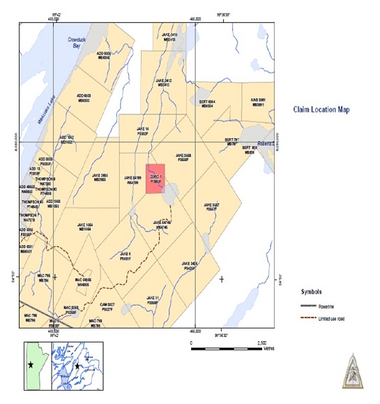
The Zoro 1 property is covered by one claim, the Zoro 1 (P1993F) (Figure 4.2; Table 4.1). The property is 52 hectares in area and was recorded March 14, 1994, under the name of Dalton Bruce Dupasquier. The claim is in good standing.
Table 4.1: Zoro 1 claim information.
|
NAME
|
NUMBER
|
HOLDER
|
STAKED
|
RECORDED
|
EXPIRES
|
HECTARES
|
|
ZORO 1
|
P1993F
|
DALTON BRUCE DUPASQUIER
|
1994/02/13 12:30
|
1994/03/14
|
2012/05/13
|
52
|
12
5.0 ACCESSIBILITY, CLIMATE, LOCAL RESOURCES, INFRASTRUCTURE AND PHYSIOGRAPHY
5.1 TOPOGRAPHY, ELEVATION AND VEGETATION
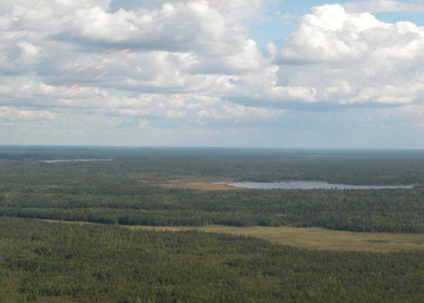
The area covered by the Zoro 1 claim lies approximately 257 m (842 feet) above sea level. The area is relatively flat with relief of about 20-40 m over 100 km. Glacial deposits and underlying bedrock surfaces influence topography. Underlying bedrock surfaces produce an undulating effect over the entire area. Ridges are generally oriented parallel to glacial ice flow (generally NE-SW) direction. Swamp/organic deposits cover about 65% of the area. Glacial Lake Agassiz sediments are the most significant surficial geological unit with glaciolacustrine silts and clays and minor till blanketing the area. Bedrock exposure forms an estimated 5% of the surface area and approximately 40% of the area is covered with fresh water lakes and swamp.
Jackpine, black spruce, poplar, birch, tamarack, alder bushes and Labrador tea are the main trees and vascular plants growing in the region. Less common are berry bushes and cedar shrubs. A large portion of the area is dominated by marshland vegetation. Extensive areas of clay are very densely covered by forest growth.
Wildlife in the area of interest includes moose, black bear, red fox, muskrat, mink, otter, red squirrel, chipmunk, rabbit, wolves and woodland caribou. Numerous bald eagles, Sandhill cranes, blue herons, migratory water fowl (Canada goose, loons and ducks) inhabit the area. The main fish species include pike, pickerel, whitefish, lake trout and brook trout.
5.2 ACCESSIBILITY
Access to the property area is by boat, helicopter or seasonal road from Provincial Road 392. The nearest rail link is at Wekusko siding, some 20 km to the south of Herb Lake Landing.
13
5.3 LOCAL RESOURCES
The full service community of Snow Lake (population 800) is located 25 km to the west of the Zoro 1 property. Accommodation is also available at Tawow Lodge, south of the property. Daily flights from Winnipeg to Flin Flon are available with a number of airlines. Air service from Winnipeg to Snow Lake is also available with Gogal Air Services. A powerline crosscuts the area approximately 5 km south of the property.
5.4 CLIMATE
Temperature averages for the community of Flin Flon, Manitoba are given in Table 5.1 for general information only. No detailed data were available from Environment Canada for Snow Lake. The Snow Lake climate is continental and characterized by cold winters (January mean temperature -21.1oC and relatively warm summers (July mean temperature +18.3oC). Total average precipitation is 477.9 mm per annum with 342.6 mm falling as rain and 137.2 mm falling as snow (for the years 1927-1990). Wind directions and velocities are fairly well distributed, but predominate to the southeast and southwest, with strong components to the northwest, north and south. Electrical storms are common and forest fires can be problematic. Summer exploration work is best conducted between the months of May to September. Winter exploration work can be conducted from November to March.
14
Table 5.1: Monthly climate averages for Flin Flon, including temperature highs, lows and precipitation values. Flin Flon climate data from the airport (54⁰41'N, 101⁰41'W at elevation 303.9 m) (source: Environment Canada website).
|
Temperature
|
Jan
|
Feb
|
Mar
|
Apr
|
May
|
Jun
|
Jul
|
Aug
|
Sep
|
Oct
|
Nov
|
Dec
|
Year
|
||||
|
Daily Average (°C)
|
-21.4
|
-16.7
|
-9.3
|
0.7
|
8.8
|
14.9
|
17.8
|
16.6
|
9.8
|
2.7
|
-8.4
|
-18.4
|
-0.2
|
||||
|
Daily Maximum (°C)
|
-16.6
|
-11
|
-2.9
|
6.9
|
15
|
20.4
|
23.1
|
21.8
|
14.2
|
6.2
|
-5.1
|
-14
|
4.8
|
||||
|
Daily Minimum (°C)
|
-26.2
|
-22.3
|
-15.8
|
-5.5
|
2.6
|
9.3
|
12.6
|
11.4
|
5.4
|
-0.8
|
-11.7
|
-22.6
|
-5.3
|
||||
|
Extreme Maximum (°C)
|
9.5
|
10
|
15
|
27
|
32.5
|
35
|
35
|
33.9
|
30
|
24
|
17.5
|
8.3
|
|||||
|
Date (yyyy/dd)
|
1993/30
|
1984/21
|
1993/24
|
1980/30
|
1986/28
|
1988/05
|
1989/21
|
1970/08
|
1991/01
|
1987/03
|
1978/02
|
1969/01
|
|||||
|
Extreme Minimum (°C)
|
-44.5
|
-45.6
|
-41
|
-31
|
-13
|
-2
|
4.4
|
-1.5
|
-6.7
|
-16.5
|
-35
|
-44
|
|||||
|
Date (yyyy/dd)
|
1996/30
|
1974/01
|
1995/04
|
1979/06
|
1990/02
|
1987/03
|
1969/05
|
1982/27
|
1974/28
|
1996/30
|
1985/28
|
1989/19
|
|||||
|
Precipitation
|
|||||||||||||||||
|
Rainfall (mm)
|
0.1
|
0.3
|
0.9
|
8.6
|
36.9
|
66.6
|
76.5
|
66.6
|
55.3
|
25.6
|
1.4
|
0.4
|
339.2
|
||||
|
Snowfall (cm)
|
19.6
|
14.6
|
19.1
|
20
|
3.7
|
0
|
0
|
0
|
2
|
13
|
25.4
|
23.9
|
141.3
|
||||
|
Precipitation (mm)
|
17.6
|
13.4
|
19
|
28.3
|
40.6
|
66.6
|
76.5
|
66.6
|
57.3
|
38.3
|
24.8
|
21.8
|
470.8
|
||||
|
Average Snow Depth (cm)
|
33
|
39
|
32
|
8
|
0
|
0
|
0
|
0
|
0
|
1
|
11
|
25
|
|||||
|
Extreme Daily Rainfall (mm)
|
2.2
|
3.8
|
12.2
|
25.4
|
62.6
|
54
|
78.2
|
53.8
|
55.6
|
24.9
|
9.1
|
10
|
|||||
|
Date (yyyy/dd)
|
1984/02
|
1986/25
|
1987/20
|
1971/16
|
1985/04
|
1993/24
|
1981/23
|
1988/21
|
1984/07
|
1969/03
|
1974/08
|
1987/07
|
|||||
|
Extreme Daily Snowfall (cm)
|
13
|
14.2
|
24
|
39.4
|
18
|
0.4
|
0
|
0
|
14.2
|
29.6
|
25.4
|
18.6
|
|||||
|
Date (yyyy/dd)
|
1973/02
|
1987/12
|
1982/12
|
1973/20
|
1975/20
|
1987/03
|
1969/01
|
1969/01
|
1984/22
|
1991/27
|
1973/28
|
1981/06
|
|||||
15
6.0 HISTORY
The pegmatite dykes are located on the north side of a small lake between Roberts Lake and the south end of Crowduck Bay. Early in 1953, Cs No. 3-10, 12 (P 26973-80, 82), S.R. No. 1-6 (P 7877-82) and Linda 1 (P 26983) were staked by Mrs. Johanna Stoltz, Eric Stoltz, Carl Stoltz and Edwin Stoltz, and Key No. 1-4, 8-14 (P 27159-62, 27226-27, 27164-68) were staked by John Tikkanen, Hjalmar Peterson, and Loren Fredeen. These were cancelled the following year.
Lit Nos. 11-5 (P 31758-62) was staked by J.J. Johnson in 1954. In 1955 Lit Nos. 6-1l8 (P 35014-26) were added by J.A. Syme. All the Lit claims were assigned to Green Bay Uranium Limited in 1956 which changed its name to Green Bay Mining & Exploration Ltd. Early in 1956, before drilling commenced, samples containing more than 2% Li2O and containing no contaminating accessory lithium minerals and no high iron content were reported (Northern Miner, January 12, 1956). A shipment of 136 kg (300 lbs.) of spodumene was sent to Ottawa for testing in 1956. This sample assayed 1.19% Li2O, with minor NbO5. Ore dressing tests concluded that good liberation and separation could not be effected (Mineral Dressing and Process Metallurgy Report in Green Bay Mining & Exploration Ltd., Corporation File).
Over 6096 m (20 000 ft.) of diamond drilling was done on Lit No. 1-4, with at least 3048 m (10 000 ft.) of this on the main dyke. Results of the drilling on dykes 1, 3, 5 and 7 were reported to be "promising". Assays of 2.42% to 7.28% Li2O were reported from Dyke 5 (Green Bay; Corporation File). Dyke 5 was apparently 305 m long x 12 m wide (1000 x 40 ft.); Dyke No. 7, over 457 m x 24 m (1500 x 80 ft.). Several of the holes went deeper than 305 m (1000 ft.). Drilling on Lit 10, 16 and 17 amounted to 1950 m (6399 ft.). Gold was also found on the property, with a 3.3 kg (7.25 lb.) sample across 3.4 m (11 ft.) yielding $5.95 gold at $35.00 equating to approximately 0.17 ounces per ton gold (Green Bay; Corporation File).
Lithium tonnage estimates vary. An unsubstantiated visual estimate in September 1956 suggested up to 9-11 million tonnes (10-12 million tons) of Li2O occur on the entire group. In mid-March the main dyke was estimated to contain 18 million tonnes (2 million tons) grading 1.4% Li2O to a depth of 305 m (1000 ft.) in the main dyke (Northern Miner, October 25, 1956; Mulligan, 1965, p. 81). A reserve estimate of 1 815 000 tonnes grading 1.4% Li2O was
16
reported by Bannatyne (1985). In 1957, the estimate was revised to 1.72 million tonnes averaging 1.3% Li2O or 2.72 million tonnes (3.0 million tons) at l.0% Li2O in the main dyke (Mulligan, 1957a, 1957b). By March 1958, 12 different tonnage estimates had been made (Northern Miner, March 13, 1958). Also by that time, a permanent camp and a 4-mile road into the property had been built. Plans for a heavy media separation plant on the property were being prepared by the Lummus Co. of New York together with Knowles Associates and the Colorado School of Mines (Green Bay Mining & Exploration Ltd., Corporation File).
No further work on the property is known since 1957. The claims were assigned to J.A. Syme in 1963. The Zoro 1 claim is currently listed under the name of Dalton Bruce Dupasquier.
Several airborne surveys were done in the area in 1948 - 1973:
1. Inco/1948: Aeromagnetic Survey; Non-confidential assessment file 91614.
2. Canadian Nickel/1957: Airborne Electromagnetic Survey; Non-confidential assessment file 91624.
3. Hudson Bay Exploration and Development/1965: Helicopter-borne Electromagnetic and Radiometric survey; Non-confidential assessment file 91650.
4. Falconbridge Nickel Limited/1973: Airborne Electromagnetic and Magnetic Surveys; Non-confidential assessment file 91564. In 1980, J.A. Syme cancelled the Lit No. 6-18 claims and obtained Explored Area Lease No. 40 for the Lit No. 1-4 claims.
Sampling and detailed geological mapping (Scale 1:1200) of the deposit was done by Cerny et al. (1981, p. 155). The analysis of four samples of "core muscovite" had an average content (in wt %) of 0.171% Li, 0.792% Rb, 0.0702% Cs, 0.0021% Be; nine samples of beryl averaged 0.331% Li, 0.903% Na, 0.939% Cs; three samples of spodumene averaged 0.23% Na2O, 0.943% Fe as Fe2O3 (Cerny et al., 1981, p. 192).
The Lit Nos. 6-18 claims were re-staked under Nor 5 and 6 (W 49000, 49001) by Ross Colon and Moses Crane, respectively, for Noranda Exploration Company Limited in 1983.
Fedikow et al. (1986) examined quartz veins and outcrop (c.f. mineral occurrence RL-95) in the general area. The Nor 6 claim was cancelled in 1987; the Nor 5 in 1988. In 1989, this area was staked as Kelly 3 (P 8412E) by Strider Resources Limited.
17
7.0 GEOLOGICAL SETTING
7.1 BEDROCK GEOLOGY-INTRODUCTION
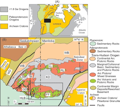
The Paleoproterozoic Flin Flon-Snow Lake Belt is approximately 200 km in strike length and has an exposed width of up to 70 km. The Belt is overlain to the south by Ordovician Red River Formation sandstone, limestone, and dolomite of the Western Canada Sedimentary Basin, and is bordered to the north by high-grade paragneiss and granitoid rocks of the Kisseynew Domain (Figure 7.1).
The Flin Flon Belt is interpreted to be an accreted assemblage of oceanic to continental margin arc terranes, interspersed with oceanic basins representing back-arc, fore-arc, and oceanic settings (Lucas et al., 1996; Syme et al., 1996). It is part of the Reindeer zone, a largely juvenile portion of the Trans-Hudson Orogen separating the Archean Superior and Hearne provinces (Figure 7.1). Recent tracer isotope studies have confirmed the presence of >3.0 Ga Archean crust (the Sask Craton) below parts of the Trans-Hudson (Lucas et al., 1996). The Shield Margin National Mapping Program (NATMAP; Lucas et al., 1996) traced the Flin Flon Belt assemblages below the Phanerozoic to the south and recognized highly metamorphosed and deformed Flin Flon volcanic and sedimentary formations (Zwanzig, 1990, 1999) within the Kisseynew Domain to the north. To the east, the Flin Flon Belt is separated from the Paleoproterozoic Thompson Nickel Belt by Kisseynew Domain rocks. To the west, the Flin Flon Belt is terminated against the Tabernor Fault Zone (Figure 7.1).
The Geological Survey of Canada (GSC)-Manitoba- Saskatchewan NATMAP Shield Margin Project and LITHOPROBE Trans-Hudson Orogen transect built on an extensive existing geological database that led to a much improved understanding of the components and evolution of the southeastern Reindeer zone, including the Flin Flon Belt (e.g., Lucas et al., 1996). These investigations have shown that, at a crustal scale, the Flin Flon "greenstone" belt is only one of three components in a northeast-dipping stack, juxtaposed during 1.84 to 1.80 Ga collisional deformation:
1. At the lowest structural level (exposed in the Pelican Window, Figure 7.2, within the Hanson Lake Block): metaplutonic rocks and paragneisses (3.20-2.40 Ga) of the "Sask craton" (Corrigan et al., 2007).
2. At intermediate structural levels: Flin Flon Belt (now defined to include the Attitti Block and Paleoproterozoic rocks in the Hanson Lake Block) and Glennie Domain, shown in Figures 7.1 and 7.2, (together comprising the "Flin Flon-Glennie Complex" [FFGC]; Lucas et al., 1996).
3. At the highest structural levels: marine turbidites (Burntwood Group; 1.85-1.84 Ga) and distal facies of alluvial-fluvial sandstones (Missi Group) in the Kisseynew Domain (Figure 7.1).
18
Figure 7.1: Location map after Hoffman (1989) illustrating the position of the Flin Flon-Snow Lake Belt in relation to the Precambrian geology of North America (A) and central Canada (B). The latter illustrates the components of the dominantly juvenile core to the Trans-Hudson Orogen in relation to the bordering Archean terranes, middle Proterozoic Athabasca Basin and overlying Phanerozoic strata of the Western Canada Sedimentary Basin. FFB: Flin Flon Belt; GD: Glennie Domain; HLB: Hanson Lake Block: LL-LT: Lynn Lake-LaRonge Belt; KD: Kisseynew Domain; RD: Rottenstone Domain; RL: Rusty Lake Belt; TB: Thompson Belt; TB: Tabernor Fault Zone; WB: Wathaman-Chipewayan Batholith; WD: Wollaston Domain. Modified from Lucas et al. (1996) from the original by Hoffman (1989). Dashed box represents area shown in more detail in Figure 7.2.
19
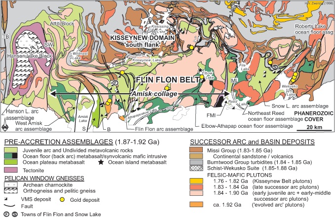
Figure 7.2: Map of the Flin Flon-Snow Lake Belt, illustrating the tectonicstratigraphic assemblages, the location of the various accretionary assemblages, and major mineral deposits. B: Birch Lake assemblage; FMI: Fourmile Island assemblage; ML: Morton Lake fault zone; S: Sandy Bay assemblage; TB: Tabernor Fault Zone; SW: Sturgeon-Weir fault zone. Modified from Zwanzig (1999) and Lucas et al. (1996).
7.2 GEOLOGICAL EVOLUTION AND COMPONENTS OF THE FLIN FLON-SNOW LAKE GREENSTONE BELT
The stratigraphy of the Flin Flon-Snow Lake Belt has been previously subdivided into two major groups, the Amisk Group metavolcanic rocks and Missi Group continental metasedimentary rocks (Bruce, 1918; Harrison, 1951). The Flin Flon Belt is now recognized as consisting of several 1.9 to 1.88 Ga terranes comprised of four main tectono-stratigraphic assemblages that represent both juvenile and continentally underlying oceanic segments of a Paleoproterozoic ocean basin that were accreted during formation of the Trans- Hudson orogen (Syme, 1990; Syme and Bailes, 1993; Stern et al., 1995a, b; Lucas et al., 1999; Figs. 1, 2). The orogen was formed by oblique collision between the Superior and Hearne Archean terranes, and the resulting collage is separated into a number of assemblages distinguished by unique tectono-stratigraphy, and dismembered by fault systems that were
20
originally thrust surfaces (Syme, 1995, Lucas et al., 1996). Each tectonostratigraphic assemblage is a distinct package of rocks in terms of its stratigraphy, geochemistry, isotopic signature, age, and inferred plate tectonic setting (see below; Syme and Bailes, 1993; Lucas et al., 1996; Corrigan et al., 2007).
The tectonostratigraphic assemblages were juxtaposed in an accretionary complex at ca. 1.88 to 1.87 Ga, probably as a result of arc-arc collision (D1; Lucas et al., 1996; Stern et al., 1999). Accretionary collage-bounding structures were largely obliterated by subsequent deformation and metamorphic events (D2-D5), but are inferred where juxtaposed terranes are "stitched" together by calc-alkaline plutons related to a 1.866 to 1.838 Ga successor arc formation (Whalen et al., 1999). Coeval subaerial volcanism is recorded in ca. 1.87 to 1.85 Ga calc-alkaline to shoshonitic volcaniclastic sequences (Syme, 1988; Bailes and Syme, 1989; Lucas et al., 1996; Stern et al., 1996). Unroofing of the accretionary collage, development of a paleosol, and deposition of alluvial-fluvial sedimentary rocks (Missi suite; Bailes and Syme, 1989; Holland et al., 1989) occurred ca. 1.85 to 1.84 Ga (Ansdell, 1993). These events were coeval with the waning stages of post-accretion arc magmatism (Stern and Lucas, 1994; Whalen and Hunt, 1994; Lucas et al., 1996). Development of the Kisseynew turbidite basin (now part of the Kisseynew Domain, Figures. 1 and 2) was synchronous with continental sedimentation in the Flin Flon Belt (Ansdell, 1993; David et al., 1993, 1996; Machado and Zwanzig, 1995; Connors, 1996; Connors et al., 1999).
The transition from Kisseynew basin extension to collisional collapse occurred rapidly at about 1.840 Ga, although sedimentation and magmatism continued through to ~1.830 Ga (Ansdell and Norman, 1995; Machado and Zwanzig, 1995; David et al., 1996; Connors et al., 1999). The Kisseynew Domain was thrust over the Amisk collage along the southern flank of the Kisseynew Domain (Harrison, 1951; Zwanzig, 1990; Lucas et al., 1994; Connors, 1996; Connors et al., 1999; Zwanzig, 1999). Following collisional thickening and peak metamorphism at 1.83 to 1.80 Ga, the Flin Flon Belt experienced protracted intracontinental deformation to ca. 1.69 Ga (Lucas et al., 1996; Stern et al., 1999).
The Flin Flon-Snow Lake Belt consists of two principal segments (Amisk collage and Snow Lake arc assemblage) that were juxtaposed during southwest-verging continent-continent collision between 1.84 and 1.82 Ga. To the west of the Amisk collage is a volcano-sedimentary domain of similar age (Hanson Lake arc assemblage; Figure 7.2). Although not traditionally designated as part of the Flin Flon Belt, the Hanson Lake arc assemblage will
21
be included here due to the presence of volcano-sedimentary rock units and several VMS occurrences and deposits of similar age (Maxeiner et al., 1993, 1999).
Although each of these three tectonic segments has a distinct character, their metallogenic tenor is a product of the same three tectonically controlled evolutionary stages of the region. The first is represented by syngenetic polymetallic base metal and precious metal deposits and occurrences that formed during a pre-accretionary stage within distinct oceanic, supra-subduction environments. The second consists of post-accretion intrusion-related mineralization associated with successor arc formation and extensional magmatism. The third is comprised of shear zone-related orogenic Au deposits that formed during periods of collision, oblique compression, and crustal thickening.
The Amisk collage is comprised of a series of fault-bounded tectonostratigraphic assemblages (Syme, 1995; Lucas et al., 1996; Figure). These are intruded by post-accretionary plutons and are overlain by fluvial-alluvial sedimentary rocks of the Missi Group. The collage is bounded to the west by the Sturgeon-Weir fault system, to the east by the Morton Lake fault zone, and to the north by the southern flank of the Kisseynew domain. It extends to the south below the Phanerozoic cover. The Amisk collage contains the West Amisk, Birch Lake, Flin Flon, and Fourmile Island oceanic arc assemblages, and the Sandy Bay and Elbow-Athapapuskow back-arc basin basalt assemblages (Stern et al., 1999; Syme et al., 1999; Figure 7.2).
The arc and ocean floor assemblages in the eastern part of the Flin Flon Belt are collectively sufficiently distinct from the Amisk collage arc assemblages to suggest that they represent remnants of unrelated arc terranes (Lucas et al., 1996; Syme et al., 1996). This eastern part of the belt is characterized by a number of allochthons in a thrust stack that is bordered to the west by the Morton Lake fault zone and to the east and north by the overthrust Kisseynew Domain (Bailes et al., 1994; Syme, 1995). These allochthons are comprised of the Snow Lake arc and the Northeast Reed and Roberts Lake ocean floor assemblages (Figure 7.2) that are separated by major bounding fault systems. The 1.89 Ga Snow Lake arc assemblage (David et al., 1996; Bailes and Galley, 1999) is the only one that contains significant VMS mineralization. It is exposed in a thrust stack that includes several structurally imbricated slivers of 1.84 to 1.83 Ga post-accretion sedimentary strata of the Burntwood suite (Stern et al., 1995a; Connors et al., 1999). The >6 km-thick dominantly juvenile oceanic to crustally contaminated arc succession of the Snow Lake arc assemblage
22
consists of three conformable volcanic successions that record the evolution from nascent or primitive arc through mature arc, to rifting and opening of a back-arc basin.
The Hanson Lake arc assemblage structurally overlies Archean crust and contains coeval volcanic and sedimentary assemblages that are found within the neighbouring Flin Flon Belt. It is also host to numerous VMS deposits and occurrences. The fault-bounded area containing the Hanson Lake arc assemblage and underlying Archean crust is known as the Hanson Lake Block (HLB) (Figures 7.1 and 7.2).
The HLB is composed of a highly deformed and metamorphosed assemblage of 1.91 to 1.85 Ga volcanic and sedimentary rock, and 1.86 to 1.81 Ga syntectonic intrusions and migmatitic gneisses that have been thrust over the ca. 2.5 Ga Neoarchean charnokitic and enderbitic intrusive rocks known as the Pelican Window (surface expression of the Sask Craton; Ashton et al., 1987; Maxeiner et al., 1993, 1999; Ashton and Lewry, 1994; Figure 7.2). The HLB is terminated to the west by the Tabernor fault zone and to the east by the Sturgeon-Weir fault zone, which separates the HLB from those assemblages traditionally included within the Flin Flon Belt, and extends southward below the Phanerozoic cover. The principal reason for the original exclusion of the arc assemblages of the HLB from those of the Flin Flon Belt was that they were originally believed to have formed upon Archean crust and were, therefore, not considered part of the Flin Flon oceanic supra-subduction suite.
Supracrustal rocks of the HLB are dominated by metavolcanic and metasedimentary rocks. Volcanism and sedimentation are coeval from 1910 to 1880 Ma, with sedimentation continuing to at least 1850 Ma. Volcanic strata are dominantly tholeiites and include pillowed basalt overlain by intermediate to felsic flows and volcaniclastic rocks. Also present is a large felsic hypabyssal intrusive/extrusive complex. The volcanic assemblage is in contact with calc-silicate-carbonate-rich strata, silicate-facies iron formation, and polymictic conglomerate, and overlain by psammitic greywacke and mafic wacke (Maxeiner et al., 1993, 1999).
The supracrustal assemblages of the HLB are intruded by numerous synvolcanic intrusions, ranging in composition from ultramafic through gabbro and quartz diorite to rhyolitic. Large antiformal domes of migmatitic gneiss are accompanied by lit-par-lit injection into the supracrustal formations. Metamorphic grade generally increases from south to north, from upper greenschist to upper amphibolite facies, with regional metamorphism peaking between 1810 and 1806 Ma. A major folding event took place between 1860 and 1850 Ma, and was followed by 1810 to 1800 Ma continental collision that caused the thrusting of this terrane over Archean basement (Ashton and Lewry, 1994). Deformation that accompanied crustal thickening and post-peak metamorphism continued until 1770 Ma.
23
7.3 GENERAL AND DETAILED GEOLOGY
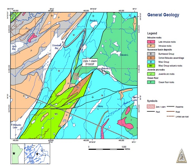
General and detailed geology for the Zoro 1 property is depicted in Figures 7.3 and 7.4. Mapping in the area of the property documents the Zoro 1 property is underlain by Ocean Floor volcanic rocks of the Roberts Lake allochthon and lesser amounts of Missi Group sedimentary rocks. The Ocean Floor rocks comprise mafic volcanic and related intrusions and the Missi Group consists of sandstone, siltstone, mudstone and quartzo-feldspathic gneiss and migmatite. These lithologies are flanked to the south by Missi Group calc alkaline and tholeiitic basalt and rhyolite to dacite ash flow tuff and flows and to the east and west more Missi Group sedimentary rocks. The Ocean Floor mafic volcanic rocks adjacent to the dykes consist of a fine- to medium-grained strongly foliated dark green lithology. These andesitic to basaltic lithologies are locally interbedded with volcaniclastic sedimentary rocks and all are intruded by a quartz-phyric granite intrusion. The flows are generally fine- to medium-grained, massive with a 50°-70° lineation and strikes of N10°-30°E and steep northwest dips. Localized quartz veins, quartz laminae and associated iron carbonate veinlets are also present in outcrop adjacent to lineaments interpreted to represent faults. Minor arsenopyrite was noted in the quartz veins and laminae. Minor arsenopyrite and pyrite were observed in the quartz veins and laminae. These rocks are locally rusty-weathered and crosscut by veinlets of iron carbonate and quartz. Minor arsenopyrite and pyrite was observed in the quartz veins and laminae.
The pegmatite dykes strike northwest to north-west with steep dips and crosscut the regional foliation at a low angle. The dykes tend to be concentric in internal structure and the grain size of the constituent minerals (potassium feldspar, quartz, spodumene and black tourmaline) coarsens towards the center of the dykes. This pattern may be locally interrupted by patches of saccharoidal albite, large muscovite aggregates and coarse albite stringers with garnet and beryl. Spodumene in concentrated in the cores of the dykes. Some of the dykes have been split into sub-parallel veins by post-emplacement tectonic activity.
The pegmatite dykes on the property are hosted in Ocean Floor mafic volcanic rocks transected by northwest-trending structures. The general area is also crosscut by a series of northeast and near-east-trending structures including the major Berry Creek fault that extends along Crowduck Bay.
24
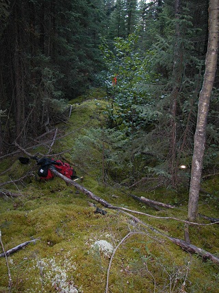
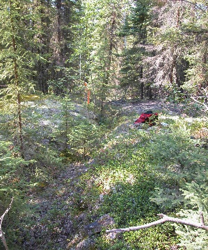
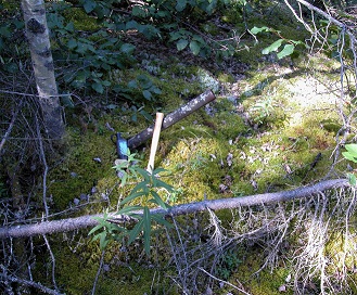
Detailed geologic observations were hampered by caved, filled and overgrown trenches (Figures 7.5 and 7.6).
Figure 7.3: General geology in vicinity of the Zoro 1 lithium pegmatite property.
25
Figure 7.4: Detailed geology at the Zoro 1 lithium pegmatite property.
Figure 7.5: Overgrown trench at the Zoro 1 lithium pegmatite property.
26
Figure 7.6: Overgrown and slumped trench at the Zoro 1 lithium pegmatite property.
7.4 METALLOGENY
The major mineralizing events recognized in the Flin Flon belt took place during the three main stages of crustal development: pre-accretion, post-accretion, and continent- continent collision. The pre-accretionary stage is represented by syngenetic base metal and Au deposits. The syn- to postaccretionary stage is characterized by several examples of intrusion-hosted base and precious metal deposits, and the continental collision stage by the development of orogenic Au deposits and REE-enriched pegmatites.
27
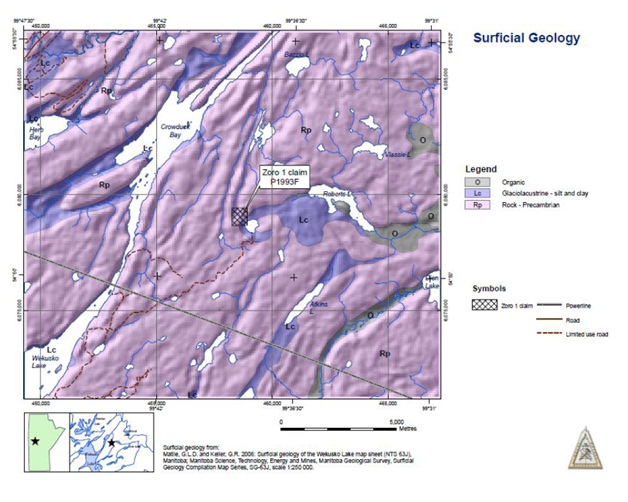
7.5 SURFICIAL GEOLOGY
Glacial sediments including till, glacio-lacustrine and glacio-fluvial deposits cover the project area (Figure 7.7). Most small streams flow primarily over organic deposits. Reworked glacial sediments form beaches on some lakes. Till and glacio-fluvial deposits associated with the Labrador and Keewatin sectors of the Laurentide Ice Sheet were developed approximately 115,000 years ago. During late Pleistocene, the ice sheet radiated southwest from Hudson Bay, and covered most of Manitoba. An extensive cover of carbonate-rich till derived from the James Bay and Hudson Bay Lowlands has been deposited over the area. As the ice sheet receded, glacial Lake Agassiz formed and resulted in the deposition of a veneer of glaciolacustrine silt and clay.
28
Figure 7.7: Surficial geology of the Zoro 1 property.
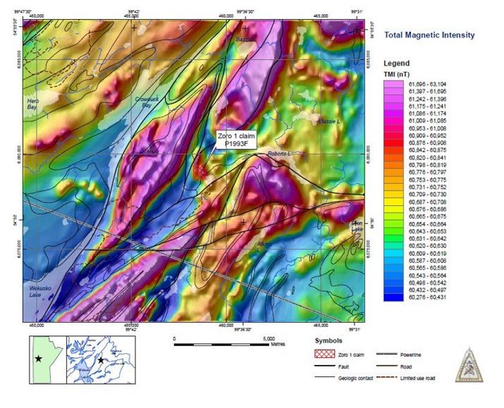
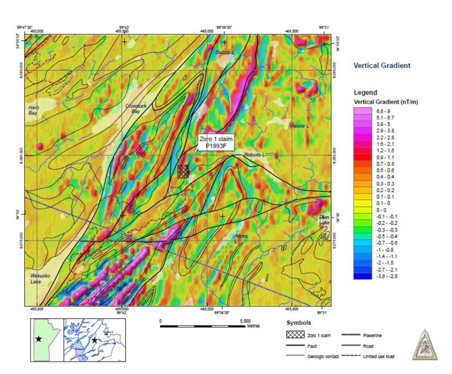
7.6 GEOPHYSICAL CHARACTERISTICS OF THE ZORO 1 PROPERTY
The Zoro 1 property occurs in a generally magnetically “active” zone in an area of low Total Magnetic Intensity. The low magnetic signature of the property area is flanked on all sides by large, very strong magnetic responses. The property encompasses two north-northeast-trending magnetic anomalies. These anomalies are visible in both the Total Magnetic Intensity and vertical Gradient maps presented in Figures 7.8 and 7.9, respectively. The more westerly of these anomalies extends the full length of the property and continues well past the northern property boundary. The eastern anomaly is confined within property boundaries but also extends the entire length of the property. Historic exploration has not fully explained these anomalies that are likely due, in part, to mineralized quartz-feldspar porphyry intrusions that occur within faults on the property and also to the pegmatite dykes that trend both north and northwest.
29
Figure 7.8: Regional airborne Total Magnetic Intensity survey results of the Zoro 1 property/Wekusko Lake area.
30
Figure 7.9: Regional airborne Vertical Gradient for the Zoro 1 property/Wekusko Lake area.
31
8.0 DEPOSIT TYPES
The Zoro 1 pegmatite dykes are classified as rare metal spodumene pegmatite. Using the pegmatite classification scheme of Rudenko et al. (1975), the Zoro 1 pegmatite dykes can be classified as rare metal spodumene pegmatite, though it may be marginal to the lepidolite sub-formation.
Table 8.1: Pegmatite classification abbreviated after Rudenko et al. (1975) showing the possible field of the Zoro 1 spodumene-lepidolite pegmatite (from Cerny, 1982).
|
Pegmatite Formation
|
Pegmatite Subformation
|
Pegmatite Type
|
Mineralization
|
Parent granites
|
Level of emplacement
|
Metamorphic grade of host
|
|||||||||||
|
Ceramic
|
Ceramic
|
Ceramic: U, REE
|
Normal biotite (?); leucocratic and alaskitic
|
Very deep
|
Granulite; sill. –alm. amphibolite
|
||||||||||||
|
Silica-bearing
|
Muscovite-bearing
|
Muscovite: U, REE, Be
|
Deep
|
Kyanite-alm. amphibolite
|
|||||||||||||
|
Rare-metal
|
Beryllium-bearing
|
Be, Ta, Nb (Sn)
|
Be (Ta, Nb)
|
Leucocratic, alaskitic
|
Intermediate (rarely shallow)
|
Staurolite-alm. Amphibolite, epidote-amphibolitic, greenschist
|
|||||||||||
|
Pollucite-bearing
|
Ta, Cs, Be, Li, Rb (Sn)
|
Be, Li, Cs, Ta, Rb
|
F, Li-bearing
|
||||||||||||||
|
Spodumene (Li)
|
Li, Be, Ta, Nb (Sn)
|
Li, Ta, Be (Nb)
|
|||||||||||||||
|
Lepidolite (F, Li)
|
Li, Ta, Be (Sn)
|
(Ta, Li, Cs, Be)
|
|||||||||||||||
|
Rare Earth-element-bearing
|
REE, U, Th, Nb
|
(REE, Nb)
|
Alkalic
|
||||||||||||||
|
Rock crystal-bearing
|
No cavities, quartz phyroblasts
|
Rock crystal
|
Leucocratic, alaskitic
|
(Intermediate) shallow
|
_
|
||||||||||||
|
Cavities – Murzinka-type
|
|||||||||||||||||
|
Cavities – Kazakhstan-type
|
|||||||||||||||||
Note: All subformations also have a ceramic pegmatite type, except the lepidolite F, Li subformation
32
9.0 MINERALIZATION
The Zoro 1 property comprises a minimum of seven zoned pegmatite dykes that intrude Proterozoic Amisk Group volcanic and volcaniclastic rocks in a 2 km zone trending approximately 55° northwest (Mulligan, 1965 in Cerny et al., 1981; Fedikow et. al., 1993). The dykes strike north to northwest and dip vertically. Several have been described as gently dipping bodies (Bannatyne, 1985). The main, most westerly dyke outcrops along the west side of a ridge, 4.5 to 6 m high, and intrudes siliceous metasedimentary rocks and amphibolite (Bannatyne, 1985). It is 27 m (90 ft.) wide and is exposed in 16 cross-trenches for a length of 183 m. Individual dykes have lengths of approximately 244 m.
The outer zones of the pegmatite dykes contain pink aplite and coarse feldspar, muscovite, tourmaline, and beryl. Spodumene, quartz, cleavelandite, and tourmaline form core zones with interstitial coarse feldspar. Spodumene is usually coarse-grained and is sometimes altered. It is most prevalent in the central 9 m (30 ft.) of the main dyke. In this dyke, spodumene crystals (up to 35 cm long) occur either in clusters, over widths of 6 m or more, or associated with coarse tourmaline and perthite megacrysts; some spodumene crystals show a preferred orientation of 45° to 55° (Bannatyne, 1985). One of two parallel dykes south of the main outcrop, is 5 m wide, and contains spodumene crystals in pods (up to 33 cm across). In other dykes, coarse grained spodumene is abundant in lenticular bands and fine-grained spodumene is distributed through aplitic patches (Bannatyne, 1985). Beryl occurs as white, anhedral to subhedral crystals less than 1 inch (2.5 cm) in diameter in three of the seven dykes. Typical mineralogy from specimens observed at the Zoro 1 pegmatite exposed in trenches are depicted in Figure 9.1. Chemical analyses for selected minerals from the Zoro 1 pegmatite dykes are presented in Table 9.1.
Columbite-tantalite and sparse minute grains of pyrite and chalcopyrite were found in thin sections (Green Bay Mining & Exploration Ltd., Corporation File). The physical characteristics of the lithium-bearing pegmatite dykes on the Zoro 1 property are presented in Table 9.2.
33
Figure 9.1: Coarse-grained bladed spodumene, muck sample, Zoro 1 property.
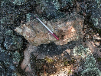
Table 9.1: The compositional characteristics of selected minerals from the Zoro 1 pegmatite (Cerny, 1981).
|
Rb
|
K/Rb
|
Cs
|
|||||||||||||||||
|
Blocky Potassium Feldspar
|
Arithmetic Mean (weight %)
|
0.392
|
33.7
|
0.0603
|
|||||||||||||||
|
(n=19 samples)
|
Standard Deviation
|
+/-0.144
|
+/-15.1
|
+/-0.0383
|
|||||||||||||||
|
Range
|
0.183-0.668
|
17.1-62.8
|
0.0158-0.1404
|
||||||||||||||||
|
Core Muscovite
|
Li
|
Rb
|
K/Rb
|
Cs
|
Be
|
||||||||||||||
|
(n=4)
|
0.171
|
0.792
|
12.5
|
0.0702
|
0.0021
|
||||||||||||||
|
+/-0.122
|
+/-0.432
|
+/-5.1
|
+/-0.0497
|
+/-0.0003
|
|||||||||||||||
|
0.025-0.460
|
0.473-1.42
|
5.9-17.7
|
0.025-0.123
|
0.0017-0.0023
|
|||||||||||||||
|
Late Beryl
|
Li
|
Na
|
Na/Li
|
Cs
|
|||||||||||||||
|
(n=9)
|
0.331
|
0.903
|
2.83
|
0.939
|
|||||||||||||||
|
+/-0.080
|
+/-0.101
|
+/-0.50
|
+/-0.452
|
||||||||||||||||
|
0.202-0.460
|
0.720-1.01
|
2.00-3.56
|
0.334-1.67
|
||||||||||||||||
|
Spodumene
|
Na2O
|
Fe as Fe2O3
|
|||||||||||||||||
|
(n=3)
|
0.230
|
0.943
|
|||||||||||||||||
|
+-0.104
|
+/-0.446
|
||||||||||||||||||
|
0.16-0.35
|
0.428-1.21
|
||||||||||||||||||
|
Garnet
|
FeO
|
MnO
|
MnOx100/MnO+FeO
|
CaO
|
MgO
|
||||||||||||||
|
(n=1)
|
24.80
|
17.10
|
40.81
|
0.46
|
0.49
|
||||||||||||||
34
Table 9.2: Summary of the pulp characteristics of the Lithium-bearing dykes on the Zoro 1 property.
|
Dyke No.
|
Length
(feet)
|
Width
(feet)
|
Orientation: Strike/Dip
|
Comment (C.A.F. 93562)
|
|||||||||||
|
1:
|
600
|
15-60
|
N30°W/75-80°E
|
medium-coarse-grained spodumene; crystals to 5” in length
|
|||||||||||
|
2:
|
|||||||||||||||
|
Northwest Dyke
|
150
|
2-7
|
N32°W/?
|
good grade in center of dyke
|
|||||||||||
|
Northeast Dyke
|
25
|
N25°W/?
|
good grade; 3" spodumene crystals
|
||||||||||||
|
South Dyke
|
250
|
6-10
|
N48°W/?
|
medium to high-grade; duplicate assays: Pulp A: 1.69% Li2O; Pulp B: 1.66% Li2O
|
|||||||||||
|
3:
|
|||||||||||||||
|
North Dyke
|
200
|
4-6
|
N40°W/?
|
medium-poor grade
|
|||||||||||
|
West Dyke
|
100
|
3-5
|
N55°W/?
|
good grade but spotty
|
|||||||||||
|
East Dyke
|
175
|
5-15
|
N40°W/?
|
high-grade but spotty
|
|||||||||||
|
4:
|
500
|
2-10
|
N35°-45°W/?
|
northwest and southeast portions of dyke have good grade but poor grade in central dyke. Bulk sample duplicate pulps; Pulp A: 1.12% Li2O; Pulp B: 1.16% Li2O
|
|||||||||||
|
5:
|
600
|
3-35
|
N60°W/?
|
medium to high-grade but spotty; bulk sample duplicate pulps; Pulp A: 2.26% Li2O; Pulp B: 2.22% Li2O
|
|||||||||||
|
6:
|
350
|
1-5
|
N25°W/?
|
poor to lean pegmatite
|
|||||||||||
|
7:
|
|||||||||||||||
|
East Dyke
|
250
|
3-10
|
N73°W/?
|
fair to good grade but spotty
|
|||||||||||
|
West Dyke
|
150N and 150W
|
15-40
|
high-grade spodumene; additional unexplored dykes (5-15’ wide) north of West Dyke.
|
||||||||||||
“?”: Dip not reported
35
9.1 OTHER MINERALIZATION
During diamond drill testing of the Zoro pegmatite disseminated pyrrhotite, chalcopyrite and arsenopyrite were observed in andesitic wallrocks adjacent to pegmatite. Assay results from the 1476’-1485’ segment of drill 22A produced a value of $5.95 gold at $35.00 equating to approximately 0.17 ounces per ton gold. Accordingly, similar mineralization observed in drill core was sampled and assayed for gold during the drill program. Assay results are summarized in Table 9.3 and indicate that uniformly low values were documented from similar mineralization. Assay sampling widths are noted to be highly variable.
Table 9.3: Summary of gold assay results from drill core at the Principal or westernmost dyke. Mineralization consisted of fine-grained, disseminated pyrrhotite, chalcopyrite and arsenopyrite.
|
DDH#
|
Sample Width
(feet)
|
Gold Assay
(opt or ounces per ton)
|
|
7
|
3
|
Trace
|
|
7
|
0.9
|
Trace
|
|
8
|
2.2
|
Trace
|
|
8A
|
1.5
|
0.01
|
|
16
|
5.5
|
0.01
|
|
16
|
2
|
0.02
|
|
16
|
3
|
0.02
|
|
16
|
4.2
|
0.02
|
|
16
|
2.6
|
0.01
|
|
24
|
9
|
0.03
|
|
24
|
3.9
|
0.01
|
36
10.0 EXPLORATION
No recent exploration programs have been conducted on the property since 1957.
37
11.0 DRILLING
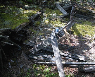
As of 1957 a total of 78 drill holes had been completed on the property by Green Bay Uranium Limited. Collar locations for this drilling are not available and only a single drill collar was located on the property by the author during a recent property visit. Table 11.1 contains a summary of drill information, including orientation, total depth, and pegmatite intersections from the available logs which are reported in cancelled assessment file 93562. Grid references to these holes are not presented; there is no surviving grid on the property from this diamond drill exploration program. Drill core racks from historic exploration on the property are depicted in Figure 11.1 and a drill stem from previous drilling in Figure 11.2.
38
Figure 11.1: Drill core from historic diamond drill programs, Zoro 1 property.
39
Figure 11.2: Drill stem from historic drill programs, Zoro 1 property.
40
Table 11.1: Summary of drill core (n=78) information from Zoro 1 pegmatite property.
|
DDH#
|
Bearing/Azimuth
|
Dip at Collar
|
Total Depth
(feet)
|
Pegmatite
Intersections (feet)
|
|
1
|
253°
|
45°
|
218
|
97-192
|
|
2
|
253°
|
45°
|
186.9
|
119-162
|
|
3
|
253°
|
45°
|
247
|
136-224
|
|
4
|
253°
|
45°
|
235.5
|
80-192
|
|
5
|
253°
|
45°
|
250
|
146-225
|
|
6
|
253°
|
45°
|
223
|
159-202
|
|
7
|
253°
|
45°
|
222
|
60-183
|
|
8
|
253°
|
45°
|
226
|
127-149
|
|
8A
|
253°
|
45°
|
193
|
111-140
|
| 9 | not drilled | |||
| 10 | not drilled | |||
|
11
|
253°
|
55°
|
567
|
375-481
|
|
12
|
253°
|
55°
|
538
|
242-508
|
|
13
|
253°
|
55°
|
469
|
22-440
|
|
14
|
253°
|
55°
|
477
|
120-436
|
|
15
|
253°
|
55°
|
449.3
|
365-430
|
|
16
|
253°
|
55°
|
402
|
312-382
|
|
17
|
253°
|
60°
|
1094
|
864-1068
|
|
18
|
73°
|
65°
|
950
|
621-862
|
|
19
|
73°
|
45°
|
334
|
184-302
|
|
20
|
73°
|
50°
|
695
|
410-483
|
|
21
|
73°
|
60°
|
781
|
544-734
|
|
22
|
73°
|
67°30'
|
1080
|
no pegmatite
|
|
22A
|
64°
|
62°
|
1511
|
no pegmatite
|
|
23
|
62°
|
60°
|
928
|
thin pegmatite intersections
|
|
24
|
62°
|
60°
|
1151.6
|
no pegmatite
|
|
25
|
100°
|
45°
|
368
|
no pegmatite
|
|
26
|
100°
|
45°
|
441
|
no pegmatite
|
|
27
|
62°
|
60°
|
1210
|
no pegmatite
|
| 28 | 134° | 60° | not drilled | |
|
29
|
240°
|
30°
|
242
|
83-213
|
|
30
|
205°
|
40°
|
277
|
181-192
|
|
31
|
255°
|
35°
|
210
|
158-161
|
|
32
|
240°
|
45°
|
251
|
88-223
|
|
33
|
358°
|
45°
|
116
|
25-43
|
41
|
34
|
50°
|
30°
|
275
|
98-99; 208-216
|
|
35
|
10°
|
30°
|
171
|
32-34
|
|
36
|
230°
|
45°
|
254
|
79-81
|
|
37
|
275°
|
45°
|
210
|
147-154
|
|
38
|
205°
|
45°
|
210
|
148-178
|
|
39
|
54°
|
40°
|
67
|
39-48
|
|
40
|
50°
|
55°
|
263
|
202-222
|
|
41
|
340°
|
30°
|
143
|
46-81
|
|
42
|
25°
|
30°
|
220
|
7-157: mixed with andesite
|
|
43
|
240°
|
45°
|
112
|
6-94: mixed with andesite
|
|
44
|
80°
|
40°
|
136
|
51-83: mixed with andesite
|
|
45
|
18°
|
30°
|
170
|
40-94: mixed with andesite
|
|
46
|
140°
|
45°
|
120
|
20-94: mixed with andesite
|
|
47
|
60°
|
45°
|
99
|
64-83
|
|
48
|
60°
|
45°
|
136
|
no pegmatite
|
|
49
|
60°
|
45°
|
156
|
no pegmatite
|
|
50
|
210°
|
45°
|
602
|
14-250: thin and mixed with andesite
|
|
51
|
30°
|
45°
|
412
|
112-311: mixed with andesite
|
|
52
|
30°
|
45°
|
446
|
76-339: mixed with andesite
|
|
53
|
30°
|
45°
|
385
|
113-341: mixed with andesite
|
|
54
|
30°
|
50°
|
389
|
36-299: mixed with andesite
|
|
55
|
30°
|
50°
|
396
|
50-318: mixed with andesite
|
|
56
|
30°
|
10°
|
227
|
68-85: mixed with andesite
|
|
57
|
64°
|
45°
|
251
|
22-183: mixed with andesite
|
|
58
|
240°
|
35°
|
326
|
191-193
|
|
59
|
35°
|
35°
|
320
|
78-202: mixed with andesite
|
|
60
|
50°
|
50°
|
246
|
194-210
|
|
61
|
50°
|
45°
|
290
|
188-195
|
|
62
|
50°
|
45°
|
229
|
116-118
|
|
63
|
60°
|
35°
|
67
|
31-48
|
|
64
|
60°
|
40°
|
42
|
14-42
|
|
65
|
60°
|
35°
|
252
|
113-213: mixed with andesite
|
42
|
66
|
80°
|
35°
|
244
|
86-211: mixed with andesite
|
|
67
|
60°
|
35°
|
175
|
56-74: mixed with andesite
|
|
68
|
60°
|
40°
|
88
|
65-74
|
|
69
|
240°
|
35°
|
200
|
61-169
|
|
70
|
50°
|
45°
|
225
|
13-17
|
|
71
|
240°
|
35°
|
171
|
65-139
|
|
72
|
49°
|
45°
|
151
|
88-119.2: mixed with andesite
|
|
73
|
240°
|
35°
|
158
|
60-127
|
|
74
|
240°
|
40°
|
189
|
67-164
|
|
75
|
60°
|
45°
|
240
|
222-223
|
|
76
|
49°
|
40°
|
205
|
154-178
|
|
77
|
229°
|
40°
|
256
|
117-117.6
|
|
78
|
60°
|
55°
|
850
|
557-807: mixed with andesite
|
43
12.0 SAMPLING METHOD AND APPROACH
The specifics of sample collection including sample lengths for historical drill holes from the Zoro 1 property are not reported in the Manitoba Government Assessment Files or other historic information sources. The assay sample intervals for gold are presented in Table 9.1.1 and indicate highly variable sample widths. It is not known what sampling methods were used. A description of the approach to outcrop and pit/trench sampling is available in Cancelled Assessment File 93562 and was produced by Dr. R. Banfield, consultant to Green Bay Mining and Exploration Ltd.
The Banfield report (cf. C.A.F. 95362) noted the following factors as critical in designing an appropriate sampling scheme for the Zoro 1 pegmatite:
1. The entire width of the pegmatite dyke required sampling.
2. The spodumene crystals varied between “a fraction of an inch to 18 inches long”.
3. The orientation of the spodumene crystals is mostly irregular but where there is orientation, the long axis of the crystals is parallel to the walls of the dyke.
Sample collection was aided by a gasoline powered portable crusher mounted on skids. Trenches approximately “2 feet wide” were blasted into the dyke and extended from wall to wall of the pegmatite at right angles to the strike of the dyke. The top one foot of rock was discarded to avoid the effects of weathering. The trench was then deepened for an additional two feet. Trenches were established every twenty-five feet. The sample that was collected for assay was two feet wide, two feet deep which at 12 cubic feet to the ton would represent a third of a ton per lineal foot of trench. It was recommended that the sample lengths be equal to five lineal feet of trench which would yield about one ton of sample.
Blasting mats were utilized to avoid scatter and loss of material and all fines were reserved and included with coarser fractions for assay. Rock fragments were crushed to maximum diameters of one inch. Subsequent to sizing the material is shovelled into a cone-shaped pile on a metal or wooden platform with subsequent material added to the top of the cone. The sample is then flattened to a thickness of 1 foot and spread out to form a ring with no material in the center of the ring. The central cone is then re-established by shovelling material back into the center of the ring. This procedure is repeated twice and then the cone is flattened to a thickness of one foot and divided into four quadrants. Two of the four quadrants are then “coned” again using the above procedure and a second set of quadrants produced. This procedure is repeated until a total of 40 pounds of sample remains. This sample is once again quartered, divided into two halves and twenty pounds bagged, labelled and sent to the analytical facility for assay. The remaining half is archived for future use.
44
13.0 SAMPLE PREPARATION, ANALYSES AND SECURITY
The sample preparation methods and quality control measures for diamond drill core, trench and muck samples have not been reported in the Manitoba Government Assessment Files or other historic sources of information. Brief comments are present in company reports in the Manitoba Government cancelled assessment files indicating that assays were based upon split core. No further information is available.
45
14.0 DATA VERIFICATION
Data verification for diamond drill core samples have not been reported in the Manitoba Government Assessment Files or other historic sources of information. A program of re-sampling drill core from DDH 5, 13, 17 and 21 was undertaken to assess previous assay databases (C.A.F. 93562). Samples were shipped to Ledoux and Company of New Jersey (U.S.A) but resulting assays are not reported.
46
15.0 ADJACENT PROPERTIES
This section is not relevant to this report.
47
16.0 MINERAL PROCESSING AND METALLURGICAL TESTING
This section is not relevant to this report.
48
17.0 MINERAL RESOURCE AND MINERAL RESERVE ESTIMATES
A reserve of “1,727,550 undiluted tons grading 0.945% Li2O based on a length of 444’ and a vertical extent of 800’” was calculated for the westernmost or “Principal Dyke” on the property. This figure was strongly influenced by “an average grade of 2.0% Li2O over a length of 600’ across an average width of 40 in surface exposure.”
The parameters of the calculations for the above stated tonnage and grade are presented here with the original units intact.
Table 17.1: Parameters for the calculation of grade and tonnage at the westernmost lithium-bearing pegmatite dyke, Zoro 1 property.
|
Horizon/Level
|
Length
(feet)
|
True Width
(feet)
|
Grade Li2O
|
|
Surface
|
600
|
40
|
2
|
|
100'
|
720
|
42.5
|
0.73
|
|
330'
|
165
|
74.8
|
0.752
|
|
550'
|
290
|
87.2
|
1.052
|
Table 17.2: Combined calculations used to derive grade and tonnage, Zoro 1 property.
| LengthxWidthxDepth=Factor | xGrade% | Grade Factor | |
|
Surface
|
600'x40'x50'=1,200,000
|
2.0
|
2,400,000
|
|
100'
|
720'x42.8'x140'=4,314,240
|
0.73
|
3,149,395
|
|
330'
|
165'x74.8x250'=3,085,500
|
0.752
|
2,314,125
|
|
550'
|
290'x87.2'x220'=5,563,360
|
1.052
|
5,841,528
|
|
Average
|
444'x52'x660'=14,163,100
|
0.967
|
13,705,048
|
49
Based on an 11 cubic foot per ton factor (in place): 14,163,100/11=1,287,550 tons to 660’.
Diamond drill hole 17 intersected a zone grading 0.882% over 204.4’ at 780 vertical feet below surface. This intersection is interpreted to be 0.882% across 110 feet true width and is assumed for the purposes of this calculation to extend 100’ laterally and 220’ vertically.
This gives:
200’ long x 110’ wide x 220’ depth/11 = 440,000 tons grading 0.882%.
The final historic resource estimate produced for the westernmost dyke was:
1,287,550 tons grading 0.967% Li2O to a depth of 660’ vertically below surface outcrop plus a possible 440,000 tons grading 0.882% to a depth of between 660’ and 880’ below outcrop.
The total undiluted tonnage was given as 1,727,550 at 0.945% Li2O. An appropriate dilution factor was given as 5%.
50
18.0 OTHER RELEVANT DATA AND INFORMATION
This section is not relevant to this report.
51
19.0 MARKETS
Lithium is the third element in the periodic table and is the lightest of all the metals, with an atomic weight of 6.94. It tends to be concentrated in residual magmas, hence its enrichment in silicic rocks and pegmatites. Lithium occurs in some 145 different minerals, but only spodumene, lepidolite, petalite, amblygonite and eucryptite have been exploited commercially (Kunasz, 1983). Lithium is also found in some saline brines in desert areas, a source of important production at present.
Lithium is the most commercially important of the rare alkali metals and finds application in a wide range of industrial processes. About 10% of lithium ores and concentrates are consumed directly in the glass, ceramic, and porcelain enamel industries. Lithium is useful in these applications because it creates favourable internal nucleation conditions and imparts high mechanical strength, thermal shock resistance, as well as good chemical resistance to the product (Kunasz, 1983; Ferrell, 1983).
Most lithium is used in the metallic form or as lithium-bearing compounds and chemicals. The most widely used compound is lithium carbonate (Li2CO3), which is added during aluminum smelting to reduce electricity consumption and fluorine emissions. Lithium carbonate is also used in the ceramics industry as a flux to lower firing temperatures and to reduce thermal expansion of enamel coatings. Lithium hydroxide (LiOH•H2O) has found an important application in lithium-based greases which maintain their viscosity over wide temperature ranges and remain stable in the presence of water. Other compounds such as lithium chloride, lithium fluoride, lithium bromide, and butyllithium have a variety of industrial uses.
The majority of lithium production is presently from pegmatitic minerals, mainly spodumene, though significant quantities of petalite, lepidolite, and amblygonite are shipped to Europe from several African countries. Spodumene has the highest theoretical lithium content of any mineral at nearly 8% Li2O, but most concentrates grade between 4 and 7.5% Li2O. Spodumene has high iron and low iron varieties, depending on the type of pegmatite from which it is derived. High iron spodumene (about 0.6 to 0.9% Fe2O3) is generally greenish in color and is crystallized in
52
unzoned pegmatites. Low iron spodumene (less than 0.05% Fe2O3) is white in colour and occurs in complex, zoned pegmatites. Low iron spodumene, such as that presently produced by the Tantalum Mining Corporation of Canada (TANCO) at Bernic Lake, Manitoba, is used in glass and ceramic manufacturing. High iron spodumene generally goes into lithium chemical production, but can be processed with high-intensity magnetic separation and chlorine leach to produce low iron, ceramic grade spodumene (Harben and Bates, 1984; Buckley, 1983; Kunasz, 1982).
Lithium still finds extensive use in the glass and ceramic industry, but the new growth area for lithium is the batteries industry. Lithium, the lightest and least-dense metal in existence, provides a number of advantages over nickel and alkaline batteries. It is used to produce batteries which now have a lifespan of 15 years that can serve as the energy source for digital cameras, cell phones, clocks, watches, and toys. Lithium batteries are far lighter than their alkaline counterparts yet can last up to eight times as long. They can also withstand very harsh conditions and temperatures that would cause alkaline batteries to malfunction. Currently, nickel batteries are more affordable than lithium, but as the supply of lithium rises the demand is also expected to rise with the result being a comparably priced better quality energy source. This has significant implications for the automobile industry and the production of lithium-powered vehicles.
The lithium market can be divided between lithium chemicals (sourced from brines or minerals), which account for some 80% of total consumption, and lithium minerals consumed directly. Reflecting growth in demand, world lithium production is estimated to have increased by some 4% per year between 2002 and 2005. The industry is characterised by a high degree of concentration of production, with two countries, Chile and Australia, together accounting for nearly two-thirds of world output and for most of the growth in production in the mid-2000s.
Sons of Gwalia in Australia produces some 60% of world output of lithium minerals (as spodumene) from the Greenbushes hard rock deposit, with output estimated at 120,000t (gross weight) in 2005. SQM of Chile, with shipments of 27,800t lithium carbonate in 2005, accounted for 36% of world production.
An interesting feature of world lithium production is the potential emergence of China as a leading supplier. The development of technology to extract lithium from high-magnesium brines has led to the start of lithium carbonate production from salt lakes in Qinghai and
53
43-101 Technical Report, Zoro 1 Property Mount Morgan Resources Ltd. Tibet provinces. In late 2005, CITIC Guorun began construction of a 35,000t per year lithium carbonate plant to exploit lithium reserves in Xitai Ginar salt lake in Qinghai province.
Portable electronic consumer products will remain the main area of growth for secondary batteries through 2010, with shipments to the Asian cellular phone market alone estimated to rise by 50% per year and growth rates in Russia and Poland reaching 70% per year. Longer-term growth will depend on the market penetration achieved by hybrid electric vehicles and on the commercialization of safe and cost-effective lithium batteries to power them.
Recently, lithium consultants TRU Group Inc announced that its updated lithium outlook concluded that the industry is not immune from the global recession and will be pushed into oversupply this year through 2013 (presentation at the Industrial Markets Lithium Supply & Markets Conference Santiago 2009). Global use of lithium will decline sharply by at least 6% in 2009 and demand is unlikely to bounce back any time soon as consumers put off buying laptops or cell phones containing lithium batteries. It is likely now that some expansions and new projects will be delayed or cancelled until market conditions improve.
The long range market picture however, remains bright because new and large uses for lithium, electric vehicle batteries and lithium alloys for aircraft, will impact demand within the five year horizon. TRU forecasts that demand will be strong and sustained in these two segments over the long term 2020.
54
20.0 INTERPRETATION AND CONCLUSIONS
The Zoro 1 rare metal spodumene pegmatite is a documented historic occurrence of lithium-bearing mineralization that has only been partially assessed by diamond drilling and trenching without a thorough assay program. The Principal or westernmost dyke has received the most exploration and assessment and any future work must be based on a total resource derived from a review of all lithium-bearing pegmatite dykes on the property. The additional dykes have received some drilling and surface outcrop sampling but detailed geological mapping for the purposes of geologic control and possible delineation of additional pegmatite has not been undertaken.
Although considerable historic drilling has been undertaken and used to derive a grade and tonnage these data has been acquired prior to the implementation of NI 43-101 and as such cannot be relied upon for reserve calculation. At best the reported grade and tonnage should be considered as a historic reserve estimate. The database resulting from assays was not accompanied by a quality assurance and quality control program and sampling and analytical specifics are also not reported. Accordingly, a Phase 1 program of mucking out trenches, channel sampling and sampling of available muck piles and diamond drilling will provide confirmation of the extent of the pegmatite at depth and along strike and provide the basis for information that will be used to expand diamond drilling and determine a modern day resource for the target.
The Zoro 1 property hosts a near-surface deposit of lithium-bearing pegmatite mineralization that extends over significant distances in one main dyke exposed by multiple trenches and in several localities elsewhere on the property. The deposit has been classified as a rare metal spodumene pegmatite and is “open” in the sense that it has not been adequately explored. In addition, potential exists for the presence of rare metals which have not been assessed by the historic assay program.
The deposit is considered to have significant merit but requires additional work.
55
21.0 RECOMMENDATIONS
21.1 EXPLORATION RECOMMENDATIONS
Initially, the Zoro 1 pegmatites should be the focus of the following exploration approaches. These are as follows:
1. Trench rehabilitation including overburden stripping and washing.
2. Geologic mapping of individual trenches at a scale of 1:20.
3. Detailed geological mapping at a scale appropriate to document relevant features on the property. This will include the seven pegmatite dykes described herein, trench locations, historic drill collars and geological attributes of the dykes. It is likely this mapping will be undertaken at a scale of 1:1000.
4. Trench and channel sampling should be undertaken to confirm historic assay results.
5. Re-log historic drill core as possible.
6. A grid should be re-established on the property and an attempt made to tie-in the collar locations of all previous drilling. This information would help to structure new diamond drill programs. Initially, an attempt should be made to re-construct the historic grid although it is unlikely this will be possible given the length of time that has elapsed since the grid was first cut.
7. The geochemistry of the spodumene with particular relevance to iron content should be evaluated. Albite-rich portions of the pegmatite should be assayed for tantalum, tin, and niobium values. Altered and mineralized wallrocks should be assayed for gold particularly where the mineral assemblage of pyrrhotite, chalcopyrite and arsenopyrite are observed. Any subsequent drill program should be accompanied by a multi-element geochemical approach to assaying core including assays for gold. This will be followed up with assays for specific metals that may be present in the pegmatite dykes. The new assay program should be accompanied by a quality assurance and quality control program.
8. Diamond drilling should initially target Dyke No. 1 with the aim of ascertaining the physical size and extent of this dyke. Additional drilling will be necessary in the vicinity of the six remaining known dykes as well as any additional lithium-bearing pegmatite uncovered during exploration on the remainder of the property.
Expenditures for this exploration are summarized in Table 21.1.
56
Table 21.1: Recommended exploration program for the Zoro 1 property.
|
Trench Rehabilitation, Geologic Mapping and Assays (Four Weeks)
|
|
|
1. Trench stripping, excavation and washing:
|
$15,000.00
|
|
2. Field technician: $250.00/day:
|
$7,000.00
|
|
3. General Laborers (n=2): $150.00/day:
|
$8,400.00
|
|
4. Geologist: $400.00/day:
|
$11,200.00
|
|
5. Assays (n=100 @ $50.00/sample):
|
$5,000.00
|
|
Drill Program
|
|
|
6. Mobilization/Demobilization of equipment and crews:
|
$10,000.00
|
|
7. Two Thousand metres of NQ coring:
|
$250,000.00
|
|
8. Moves between holes:
|
$25,000.00
|
|
9. Core trays and survey tool:
|
$8,000.00
|
|
10. Room and board @ $150.00/day for 60 days:
|
$18,000.00
|
|
11. Communications and freight:
|
$10,000.00
|
|
12. Helicopter:
|
$40,000.00
|
|
13. Helicopter fuel:
|
$7,500.00
|
|
14. Geologist @ $400.00/day for 60 days:
|
$24,000.00
|
|
15. Geologist Room and Board @ $150.00/day:
|
$9,000.00
|
|
16. Geologist Transportation/Mobilization/Demobilization/Site access:
|
$5,000.00
|
|
17. Assays @$50.00/sample for 300 samples:
|
$15,000.00
|
|
18. Report preparation:
|
$7,500.00
|
|
Sub-total:
|
$475,600.00
|
|
Contingency @ 10%:
|
$47,560
|
|
Total:
|
$523,160.00
|
57
22.0 REFERENCES
Alcock, F.J., 1920: The Reed-Wekusko map-area, northern Manitoba; Geological Survey of Canada, Memoir No. 119, 47 p.
Ansdell, K.M., 1993: U-Pb zircon constraints on the timing and provenance of fluvial sedimentary rocks in the Flin Flon and Athapapuskow basins, Flin Flon Domain, Trans-Hudson Orogen, Manitoba and Saskatchewan: Geological Survey of Canada, Paper 93-2, p. 49-57.
Ansdell, K.M., and Norman, A.R., 1995: U-Pb geochronology and tectonic development of the southern flank of the Kisseynew Domain, Trans Hudson Orogen, Canada: Precambrian Research, v. 72, p. 147-167.
Ashton, K.E., and Lewry, J.F. 1994: Vergence of the "Pelican Slide" and Sturgeon-weir Shear zone: LITHOPROBE, Report 38, p. 12-17.
Ashton, K.E., Wilcox, K.H., Wheatley, K.J., Paul, D., and de Tombe, J., 1987: The boundary zone between the Flin Flon Domain, Kisseynew gneisses, and Hanson Lake Block, northern Saskatchewan: Saskatchewan Geological Survey, Saskatchewan Energy and Mines, Miscellaneous Report 87-4, p. 131-134.
Bailes, A.H., 1971: Preliminary compilation of the geology of the Snow Lake - Flin Flon - Sherridon area; Manitoba Department of Mines and Natural Resources, Mines Branch, Geological Paper 1/71, 27 p.
Bailes, A.H., and Syme, E.C., 1989: Geology of the Flin Flon-White Lake area: Manitoba Energy and Mines, Geological Report GR87-1, 313 p.
Bailes, A.H., and Galley, A.G., 1999: Evolution of the Paleoproterozoic Snow Lake arc assemblage and geodynamic setting for associated volcanic- hosted massive sulphide deposits, Flin Flon Belt, Manitoba, Canada: Canadian Journal of Earth Science, v. 36, p. 1789-1805.
Bannatyne, B.B., 1973: Pegmatite project; in Summary of Geological Fieldwork 1973; Manitoba Department of Mines, Resources and Environmental Management, Mines Branch, Geological Paper 2/73, p. 29, 30, 33.
Bannatyne, B.B., 1985: Industrial minerals in rare-element pegmatites of Manitoba; Manitoba Energy and Mines, Geological Services, Economic Geology Report ER84-1, p. 4, 73-75, 79.
Bell, C.K., 1978: Geology, Wekusko Lake map area, Manitoba; Geological Survey of Canada, Memoir No. 384, p. 74-75.
58
43-101 Technical Report, Zoro 1 Property Mount Morgan Resources Ltd. Bruce, E.L., 1918: Amisk-Athapapuskow Lake district: Geological Survey of Canada, Memoir 105, 91 p.
Cerny, P., 1987: Petrogenesis of pegmatites in the Cat Lake - Winnipeg River and Wekusko Lake fields, Manitoba; in Centre for Precambrian Studies; University of Manitoba, Annual Report, 1987, p. 13.
Cerny, P., 1989: Contrasting geochemistry of two pegmatite fields in Manitoba: products of juvenile Aphebian crust and polycyclic Archean evolution; Precambrian Research, v. 45, November 1989, p. 215-234.
Cerny, P., Trueman, D.L., Ziehlke, D.V., Goad, B.E. and Paul, B.J., 1981: The Cat Lake - Winnipeg River and the Wekusko Lake pegmatite fields, Manitoba; Manitoba Department of Energy and Mines, Mineral Resources Division, Economic Geology Report ER80-1, p. 155, 172, 176, 185, 189-193, 202.
Connors, K.A., 1996: Unravelling the boundary between turbidites of the Kisseynew Domain and volcano-plutonic rocks of the Flin Flon domain in the eastern Trans-Hudson Orogen, Canada: Canadian Journal of Earth Sciences, v. 33, p. 811-829
Connors, K.A., Ansdell, K.M., and Lucas, S.B, 1999: Coeval sedimentation, magmatism, and fold-thrust development in the Trans-Hudson Orogen: Propagation of deformation into an active continental arc setting, Wekusko Lake area, Manitoba: Canadian Journal of Earth Sciences, v. 36, p. 275-291.
Corrigan, D., Galley, A., and Pehrsson, S., 2007: Tectonic evolution and metallogeny of the southwestern Trans-Hudson Orogen: Geological Association of Canada, Mineral Deposits Division, Special Publication 5, p. 881-902.
David, J., Machado, N., Bailes, A., and Syme, E., 1993: U-Pb geochronology of the Proterozoic Flin Flon-Snow Lake Belt: New results: LITHOPROBE, Report 34, p. 84-87.
David, J., Bailes, A.H., and Machado, N., 1996: Evolution of the Snow Lake portion of the Paleoproterozoic Flin Flon and Kisseynew belts, Trans-Hudson Orogen, Manitoba, Canada: Precambrian Research, v. 79, p. 107-124.
Energy, Mines and Resources Canada. 1987: Canadian mineral deposits not being mined in 1986; Mineral Bulletin MR 213, p. 211.
Fedikow, M.A.F., Roney, C.T., Schmidt, G.J. and Robbie, T.J., 1986: Mineral deposit studies in the Snow Lake area; in Manitoba Energy and Mines, Minerals Division, Report of Field Activities, 1986, p. 77, 80, 84.
Fedikow, M.A.F., Athayde, P. and Galley, A.G. 1993: Mineral deposits and occurrences in the Wekusko Lake area, 63J/13; Mineral Deposit Series Report No.14, Manitoba Energy and Mines, Geological Services Branch, 460p. includes M.D.S. Map No.14, 1:50 000.
59
Frarey, M.J., 1948: Crowduck Bay (Descriptive Notes); Geological Survey of Canada, Paper 48-22.
Frarey, M.J., 1950: Crowduck Bay (Descriptive Notes); Geological Survey of Canada, Map 987A.
Galley, A.G., Syme, E.C., and Bailes, A.H., 2007a, Metallogeny of the Paleoproterozoic Flin Flon Belt, Manitoba and Saskatchewan, in Goodfellow, W.D., ed., Mineral Deposits of Canada: A Synthesis of Major Deposit Types, District Metallogeny, the Evolution of Geological Provinces, and Exploration: Mineral Deposits, Special Publication No.5, p.509-531.
Harrison, J.M., 1951: Precambrian correlation and nomenclature, and problems of the Kisseynew gneisses in Manitoba: Geological Survey of Canada, Bulletin 20, 53 p.
Hoffman, P.F., 1989: Precambrian geology and tectonic history of North America, in A.W. Bailey, and Palmer, A.R., eds., The Geology of North America-An overview: Geological Society of America, Boulder, Co., p. 447-512.
Holland, H.D., Feakes, C.R., and Zbinden, E.A., 1989: The Flin Flon paleosol and the composition of the atmosphere 1.8 BYBP: American Journal of Science, v. 289, p. 362-389.
Lucas, S.B., White, D., Hajnal, Z., Lewry, J., Green, A., Clowes, R., Zwanzig, H., Ashton, K., Schledewitz, D., Stauffer, M., Norman, A., Williams, P.F., and Spence, G., 1994: Three-dimensional collisional structure of the Trans-Hudson orogen, Canada: Tectonophysics, v. 232, p. 161-178.
Lucas, S.B., Stern, R.A., Syme, E.C., Reilly, B.A., and Thomas, D.J., 1996: Intraoceanic tectonics and the development of continental crust; 1.92- 1.84 Ga evolution of the Flin Flon Belt, Canada: Bulletin of the Geological Association of America, v. 108, no. 5, p. 602-629.
Lucas, S.B., Syme, E.C., and Ashton, K.E., 1999: New perspectives on the Flin Flon Belt, Trans-Hudson Orogen, Manitoba and Saskatchewan: An introduction to the special issue on the NATMAP Shield Margin Project, Part 1: Canadian Journal of Earth Sciences, v. 36, p. 135-140.
Machado, N., and Zwanzig, H., 1995: U-Pb geochronology of the Kisseynew Domain in Manitoba: Provenance ages for the metasediments and timing of magmatism: LITHOPROBE, Report 38, p. 133-142.
Manitoba Mines Branch:
a. Corporation Files; Green Bay Mining & Exploration Ltd.; b. Non-confidential Assessment Files; File Nos. 91564, 91614, 91624, 91650, 93562, 73164 and 73601.
Matile, G.L.D. and Keller, G.H. 2006: Surficial Geology of the Wekusko Lake Map Sheet (63J), Manitoba; Manitoba Science, Technology, Energy and Mines, Manitoba Geological Survey, Surficial Geology Compilation Map Series, SG-63J, Scale 1:250 000.
60
Maxeiner, R.O., Sibbald, T.I.I., and Watters, B.R., 1993: Geology of the Hanson Lake area (part of NTS 63L/10): Saskatchewan Geological Survey, Saskatchewan Energy and Mines, Miscellaneous Report 93-4, p. 40-49.
Maxeiner, R.O, Sibbald, T.I, Slimmon, W.L., Heaman, L.M., and Watters, B.R., 1999: Lithogeochemistry of volcano-plutonic assemblages of the southern Hanson Lake Block and southeastern Glennie Domain, Trans- Hudson Orogen: Evidence for a single island arc complex: Canadian Journal of Earth Science, v. 36, p. 209-225.
Mulligan, R., 1957a: Lithium in Canada - recent developments and geological features; Canadian Mining Journal, v. 78, No. 4, p. 125.
Mulligan, R., 1957b: Lithium deposits of Manitoba, Ontario, and Quebec 1956; Geological Survey of Canada, Paper 57-3, p. 23-24.
Mulligan, R., 1960: Beryllium occurrences in Canada; Geological Survey of Canada, Paper 60-21, p. 18.
Mulligan, R., 1965: Geology of Canadian lithium deposits; Geological Survey of Canada, Economic Geology Report No. 21, p. 80-82.
Mulligan, R., 1968: Geology of Canadian beryllium deposits; Geological Survey of Canada, Economic Geology Report No. 23, p. 70-71.
Phillips, K.A., 1978, Minerals of Manitoba, Volume 1: Non-metallic and pegmatitic; Manitoba Department of Mines, Resources and Environmental Management, Mineral Resources Division, MRD Educational Series 78/1, p. 75.
Russell, G.A., 1957: Structural studies of the Snow Lake - Herb Lake area; Manitoba Mines Branch, Publication 55-3, p. 29.
Sabina, A.P., 1972: Rocks and minerals for the collector, La Ronge-Creighton, Saskatchewan; Flin Flon-Thompson, Manitoba; Geological Survey of Canada, Paper 71-27, p. 60-61.
Sabina, A.P., 1987: Rocks and minerals for the collector, La Ronge-Creighton, Saskatchewan; Flin Flon-Thompson, Manitoba; Geological Survey of Canada, Miscellaneous Report 42, p. 50.
Stern, R.A., and Lucas, S.B., 1994: U-Pb zircon constraints on the early tectonic history of the Flin Flon accretionary collage, Saskatchewan: Geological Survey of Canada, Current Research 1994-F, Report 8, p. 75-86.
Stern, R.A., Syme, E.C., Bailes, A.H., and Lucas, S.B., 1995a: Paleoproterozoic (1.86-1.90 Ga) arc volcanism in the Flin Flon Belt, Trans-Hudson Orogen, Canada: Contributions to Mineralogy and Petrology, v. 119, p. 117-141.
61
Stern, R.A., Syme, E.C., and Lucas, S.B., 1995b: Geochemistry of 1.9 Ga MORB- and OIB-like basalts from the Amisk collage, Flin Flon Belt, Canada: Evidence for an intra-oceanic origin: Geochimica et Cosmochimica Acta, v. 59, p. 3131-3154.
Stern R.A., David, J., Lucas, S.B., and Syme, E.C., 1996: Chronology of crustal growth: 1.9-1.8 Ga magmatism and accretion tectonics in the Flin Flon Belt, Trans-Hudson Orogen (Canada): Precambrian '95 International Conference on Tectonics and Metallogeny of Early/Mid Precambrian Orogenic Belts, August 28 to September 1, 1995, Montreal, Quebec, Special Issue, p. 21-27.
Stern, R.A., Machado, N., Syme, E.C., Lucas, S.B., and David, J., 1999: Chronology of crustal growth and recycling in the Paleoproterozoic Amisk collage (Flin Flon Belt), Trans-Hudson Orogen, Canada: Canadian Journal of Earth Science, p. 1807-1827.
Syme, E.C., 1988: Athapapuskow Lake Project: Manitoba Energy and Mines, Minerals Division, Report of Field Activities, 1988, p. 20-34.
Syme, E.C., 1995: 1.9 Ga arc and ocean floor assemblages and their bounding structures in the central Flin Flon Belt: LITHOPROBE, Report No. 48, p. 261-272.
Syme, E.C., and Bailes, A.H., 1993: Stratigraphic and tectonic setting of volcanogenic massive sulphide deposits, Flin Flon, Manitoba: Economic Geology, v. 88, p. 566-589.
Syme, E.C., Bailes, A.H., and Lucas, S.B., 1996: Tectonic assembly of the Paleoproterozoic Flin Flon Belt and setting of VMS deposits: Geological Association of Canada/Mineralogical Association of Canada Joint Annual Meeting, Winnipeg, Manitoba, May 27-29, 1996, Field Trip Guidebook B1, 131 p.
Syme, E.C., Lucas, S.B., Bailes, A.H., and Stern, R.A., 1999: Contrasting arc and MORB-like assemblages in the Paleoproterozoic Flin Flon Belt, Manitoba, and the role of intra-arc extension in localizing volcanic- hosted massive sulphide deposits: Canadian Journal of Earth Sciences, v. 36, p. 1767-1788.
Wanless, R.K., Stevens, R.D., Lachance, G.R. and Edmonds, C.M., 1967: Age determinations and geological studies, K-Ar isotopic ages, Report 7; Geological Survey of Canada, Paper 66-17, p. 78-79.
Whalen, J.B., Syme, E.C., and Stern, R.A., 1999: Geochemical and Nd isotopic evolution of Paleoproterozoic arc-type granitoid magmatism in the Flin Flon Belt, Trans-Hudson orogen, Canada: Canadian Journal of Earth Science, v. 36, p. 227-250.
Whalen, J.B., and Hunt, P.A., 1994: Geochronological study of granitoid rocks in the Elbow Lake map area, Manitoba: A portion of the Flin Flon Domain of the Trans-Hudson Orogen: Geological Survey of Canada, Current Research 1994-F, Report 8, p. 1-10.
Wright, J.F., 1934: The Pas sheet, Manitoba and Saskatchewan (Marginal Notes); Geological survey of Canada.
Ziehlke, D.V., 1977: Petrogenesis of pegmatites in the Herb Lake area; in Centre for Precambrian Studies; University of Manitoba, Annual Report, 1977, p. 25, 30-31.
62
Zwanzig, H.V., 1990: Kisseynew gneiss belt in Manitoba: stratigraphy, structure, and tectonic evolution: Geological Association of Canada, Special Paper 37, p. 95-120.
Zwanzig, H.V.1999: Structure and stratigraphy of the south flank of the Kisseynew Domain in the Trans-Hudson Orogen, Manitoba: Implications for 1.845-1.77 Ga collision tectonics: Canadian Journal of Earth Science, v. 36, p. 1859-1880.
MAP REFERENCES
#Map 63J/13, Herb Lake, (Topographic), Scale 1:50 000 - Mines and Technical Surveys, Canada.
Map 2566 G, Herb Lake, (Aeromagnetic), Scale 1:63 360 - Manitoba Mines Branch and Geological Survey of Canada.
Map 25019G (Airborne electromagnetic and AFMAG), Scale 1:50 000, Geological Survey of Canada (1970).
Map 36063G, Wekusko Lake, (Airborne gamma ray spectrometry), Scale 1:250 000, Province of Manitoba, Geological Survey of Canada (1979).
Maps, Snow Lake area, (Airborne geophysical surveys: airborne gamma ray spectrometry, VLF electromagnetic and Total Field magnetic), Scales 1:250 000, colour maps, 1:150 000, stacked profiles; GSC Open File 2300, Geological Survey of Canada (1990).
Maps C 21507G, C 41507G, Herb Lake, (Aeromagnetic Total Field and Vertical Gradient, colour compilation maps), Scale 1:50 000, Manitoba Energy and Mines and Geological Survey of Canada (1990).
Maps 63J/13 a, b; g, h, (Aeromagnetic Vertical Gradient/Total Field and VLF EM surveys), Scale 1:20 000; GSC Open File 2219, Geological Survey of Canada (1990).
Map 1801, Reed and Wekusko Lakes region, (Geology), Scale 1:126 720; accompanying Memoir by Alcock (1920), Geological survey of Canada.
Map 268A, The Pas sheet, Manitoba and Saskatchewan, (Geology), Scale 1:506 880; accompanying Marginal Notes by Wright (1934), Geological Survey of Canada.
Preliminary Map 48-22, Crowduck Bay, (Geology), Scale 1:31 680, by M.J. Frarey, 1946-1947; accompanying Descriptive Notes by Frarey (1948), Geological Survey of Canada.
Map 987A, Crowduck Bay, (Geology), Scale 1:63 360, by M.J. Frarey, 1946-1948; accompanying Descriptive Notes by Frarey (1950), Geological Survey of Canada.
Map 1423A, Wekusko Lake, (Geology), Scale 1:250 000, by J.E. Armstrong, 1939, M.J.
63
Frarey, 1946-1948, G.A. Russell, 1954-1955, C.K. Bell, 1962-1963, compiled by W.L. Davison; accompanying Memoir by Bell (1978), Geological Survey of Canada.
Map, Snow Lake - Flin Flon - Sherridon area, (Geological compilation), Scale 1:253 440, by A.H. Bailes, 1970; accompanying Paper by Bailes (1971), Manitoba Mines Branch.
Map ER80-1-4, Wekusko Lake pegmatite field, (Geology), Scale 1:100 000 - Accompanying Report by Cerny et al. (1981), Manitoba Energy and Mines.
Claim Map Series, 63J/13 SE, Scale 1:31 680, circa 1976, 1980, 1982, Mining Recording, Manitoba Mines Branch.
64
23.0 CERTIFICATE OF QUALIFIED PERSON
I, Mark Fedikow, of Winnipeg, Manitoba, do hereby certify that as the author of this technical report on the 4th of September 2009, I hereby make the following statements:
· I am an independent consulting geologist and geochemist representing Mount Morgan Resources Ltd. with a business address at 50 Dobals Road North, Lac du Bonnet, Manitoba, Canada R0E 1A0.
· I am a graduate of the University of Windsor having earned Honours B.Sc. (1975) and M.Sc. (1978) degrees. I am also a graduate of the School of Applied Geology, University of New South Wales (Sydney, Australia) where I obtained a Ph. D. In Exploration Geochemistry.
· I am a member in good standing of the Association of Professional Engineers and Geoscientists of Manitoba (Certificate 4658) and am registered as a Certified Professional Geologist (“C.P.G.”) by the American Institute of Professional Geologists (Westminster, Colorado; Member No. 11039).
· I have practiced my profession continuously since graduation as an employee of junior and major mining companies, as a geologist and geochemist with the Manitoba Geological Survey and as an independent consultant.
· I have read the definition of “qualified person” set out in National Instrument 43-101 (NI 43-101) and certify that, by reason of my education, affiliation with a professional association (as defined in NI 43-101) and past relevant work experience, I fulfill the requirements to be a “qualified person” for the purpose of NI 43-101.
· My relevant experience with respect to the Zoro 1 property and pegmatite exploration includes independent exploration geochemical and geological projects with the Manitoba Geological Survey.
· I am responsible for the preparation of all portions of this technical report titled “NI 43-101 Technical Report on the Zoro 1 property, Wekusko Lake Area, Manitoba (NTS 63J13)”, dated September 4th, 2009. In addition, I visited the property during the period August 26-30th, 2009.
· As of the date of this Certificate, to my knowledge, information and belief, this Technical Report contains all scientific and technical information that is required to be disclosed to make the technical report not misleading.
· I am independent of the Issuer as defined by Section 1.4 of the Instrument.
65
· I have read National Instrument 43-101 and the Technical Report has been prepared in compliance with National Instrument 43-101 and Form 43-101F1.
Signed and dated this 4th day of September, 2009 at Winnipeg, Manitoba
____________________
Siganture