Attached files
| file | filename |
|---|---|
| EX-32.1 - EXHIBIT 32.1 - CatchMark Timber Trust, Inc. | exhibit321section906cert_2.htm |
| EX-31.2 - EXHIBIT 31.2 - CatchMark Timber Trust, Inc. | exhibit312section302pfocer.htm |
| EX-31.1 - EXHIBIT 31.1 - CatchMark Timber Trust, Inc. | exhibit311section302certpe.htm |
| EX-10.7 - EXHIBIT 10.7 - CatchMark Timber Trust, Inc. | exhibit107creditagreementa.htm |
| EX-10.6 - EXHIBIT 10.6 - CatchMark Timber Trust, Inc. | exhibit106optionagreementb.htm |
| EX-10.5 - EXHIBIT 10.5 - CatchMark Timber Trust, Inc. | exhibit105optionagreementb.htm |
| EX-10.4 - EXHIBIT 10.4 - CatchMark Timber Trust, Inc. | exhibit104optionagreementb.htm |
| EX-10.2 - EXHIBIT 10.2 - CatchMark Timber Trust, Inc. | exhibit102psacttfiasouthwe.htm |
| 10-Q - 10-Q - CatchMark Timber Trust, Inc. | cttq3201810-q.htm |
FIRST AMENDMENT TO
PURCHASE AND SALE AGREEMENT
This First Amendment to Purchase and Sale Agreement (this “Amendment”) is entered into and effective as of October 4, 2018, by and among CATCHMARK HBU, LLC, a Delaware limited liability company (“HBU”), CATCHMARK SOUTHERN TIMBERLANDS II, L.P., a Delaware limited partnership (“Southern Timberlands”), CATCHMARK TRS HARVESTING OPERATIONS, LLC, a Delaware limited liability company (“TRS”), and CATCHMARK TEXAS TIMBERLANDS, L.P., a Texas limited partnership (“Texas Timberlands”, and collectively with HBU, TRS and Southern Timberlands, “Seller”), and FOREST INVESTMENT ASSOCIATES L.P., a Delaware limited partnership (hereinafter referred to as “Purchaser”).
W I T N E S S E T H:
WHEREAS, Seller and Purchaser entered into that certain Purchase and Sale Agreement dated effective August 20, 2018 (with all exhibits, addenda and amendments thereto, the “Contract”), covering certain real property located in Hardin, Jasper, Liberty, Newton, Orange, Polk and Tyler Counties, Texas, and Allen, Beauregard, Calcasieu, DeSoto, Natchitoches, Rapides, Sabine and Vernon Parishes, Louisiana containing approximately 55,702 acres, (the “Property”), as more particularly described in the Contract; and
WHEREAS, Seller and Purchaser have agreed to Cruise Specifications as set forth on Exhibit J attached hereto and hereby made a part hereof; and
WHEREAS, pursuant to Section 35(c) of the Contract, Seller has exercised its one (1) time right to elect to remove certain entire stands from the list of Reserved Harvest Stands, and Exhibit K-2 attached hereto and hereby made a part hereof reflects the so updated Reserved Clearcut Harvest Stands, and there was no change in the Reserved Thinning Harvest Stands resulting from such removal; and
WHEREAS, pursuant to the last paragraph of Section 35 of the Contract, as a result of the update of the list of Reserved Clearcut Harvest Stands, the Value Table has been updated to Exhibit F attached hereto and hereby made a part hereof and the Purchase Price has been updated to $80,401,422.88; and
WHEREAS, Seller and Purchaser have agreed to enter into this Amendment on the terms and conditions set forth herein.
NOW, THEREFORE, for good and valuable consideration, the receipt and sufficiency of which are hereby acknowledged, the undersigned parties hereby agree to amend the Contract as follows:
1.The phrase “SEVENTY EIGHT MILLION FIVE HUNDRED THOUSAND AND NO/100 DOLLARS ($78,500,000.00)” in Section 2 of the Contract is hereby deleted in its entirety and the following is inserted in lieu thereof:
“EIGHTY MILLION FOUR HUNDRED ONE THOUSAND FOUR HUNDRED TWENTY-TWO AND 88/100 DOLLARS ($80,401,422.88)”
2.Exhibit F of the Contract is hereby deleted in its entirety and Exhibit F attached hereto is inserted in lieu thereof.
3.Exhibit J of the Contract is hereby deleted in its entirety and Exhibit J attached hereto is inserted in lieu thereof.
4.Exhibit K-2 of the Contract is hereby deleted in its entirety and Exhibit K-2 attached hereto is inserted in lieu thereof.
5.The parties acknowledge and agree that Seller has used its one (1) time right to remove entire stands from the list of Reserved Harvest Stands and Section 35(c) and the last paragraph of Section 35 of the Contract are of no further force or effect. Exhibit L of the Contract is hereby deleted in its entirety.
6.In the event of any conflict between the terms of this Amendment and the terms of the Contract, the terms of this Amendment shall control.
7. Except as otherwise amended hereby, all of the other terms and provisions of the Contract are and shall remain in full force and effect and are hereby ratified by the parties hereto. All capitalized but undefined terms used in this Amendment shall have the meanings ascribed in the Contract.
8. This Amendment may be executed in any number of counterparts, each of which shall be an original and all of which together shall constitute but one and the same instrument. The delivery of counterpart signatures by facsimile transmission or e-mail of PDF format electronic copy shall have the same force and effect as the delivery of a signed hard copy.
[Signatures begin on following page]
WITNESS THE EXECUTION HEREOF as of the date first set forth above.
SELLER:
CATCHMARK HBU, LLC, a Delaware limited liability company
By: /s/ Don Warden
Name: Don Warden
Title: Vice President
Real Estate and Alternative Income
(SEAL)
CATCHMARK SOUTHERN TIMBERLANDS II, L.P., a Delaware limited partnership
By: /s/ Don Warden
Name: Don Warden
Title: Vice President
Real Estate and Alternative Income
(SEAL)
CATCHMARK TRS HARVESTING OPERATIONS, LLC, a Delaware limited liability company
By: /s/ Don Warden
Name: Don Warden
Title: Vice President
Real Estate and Alternative Income
(SEAL)
CATCHMARK TEXAS TIMBERLANDS, L.P., a Texas limited partnership
By: /s/ Don Warden
Name: Don Warden
Title: Vice President
Real Estate and Alternative Income
(SEAL)
PURCHASER:
FOREST INVESTMENT ASSOCIATES L.P.
By: Forest Investment Associates, LLC
Its General Partner
By: /s/ Charles L. VanOver (SEAL)
Name: Charles L. VanOver
Title: Vice President
Portions of the exhibit, indicated by the mark “[***],” were omitted and have been filed separately with the Securities and Exchange Commission pursuant to the Registrant’s application requesting confidential treatment pursuant to Rule 24b-2 of the Securities Exchange Act of 1934, as amended.
Exhibit F
Land | Acres | Per Acre Value | Total Value |
Total | [***] | $ [***] | $ [***] |
Merchantable Timber (Planted Stands) | |||
Product | Volume (tons) | Unit Value | Total Value |
Pine Pulpwood | [***] | $ [***] | $ [***] |
Pine Chip-n-saw | [***] | $ [***] | $ [***] |
Pine Sawtimber | [***] | $ [***] | $ [***] |
Hardwood Pulpwood | [***] | $ [***] | $ [***] |
Hardwood Sawtimber | [***] | $ [***] | $ [***] |
Total | [***] | $ [***] | |
Merchantable Timber (Natural Stands) | |||
Product | Volume (tons) | Unit Value | Total Value |
Pine Pulpwood | [***] | $ [***] | $ [***] |
Pine Chip-n-saw | [***] | $ [***] | $ [***] |
Pine Sawtimber | [***] | $ [***] | $ [***] |
Hardwood Pulpwood | [***] | $ [***] | $ [***] |
Hardwood Sawtimber | [***] | $ [***] | $ [***] |
Total | [***] | $ [***] | |
Premerchantable Timber (Age 0-14) | |||
Age | Acres | Per Acre Value | Total Value |
CC | [***] | $ [***] | $ [***] |
0 | [***] | $ [***] | $ [***] |
1 | [***] | $ [***] | $ [***] |
2 | [***] | $ [***] | $ [***] |
3 | [***] | $ [***] | $ [***] |
4 | [***] | $ [***] | $ [***] |
5 | [***] | $ [***] | $ [***] |
6 | [***] | $ [***] | $ [***] |
7 | [***] | $ [***] | $ [***] |
8 | [***] | $ [***] | $ [***] |
9 | [***] | $ [***] | $ [***] |
10 | [***] | $ [***] | $ [***] |
11 | [***] | $ [***] | $ [***] |
12 | [***] | $ [***] | $ [***] |
13 | [***] | $ [***] | $ [***] |
14 | [***] | $ [***] | $ [***] |
Total | [***] | $ [***] | |
Total Value | $ [***] | ||
Total Value Per Acre | $ [***] | ||
Exhibit J
(see attached)
INVENTORY VERIFICATION OF THE CTT SOUTHWEST PROPERTY
LOCATED IN LOUISIANA AND TEXAS
SEPTEMBER 6, 2018
PREPARED BY:
FORESTECH INTERNATIONAL, LLC
INTRODUCTION
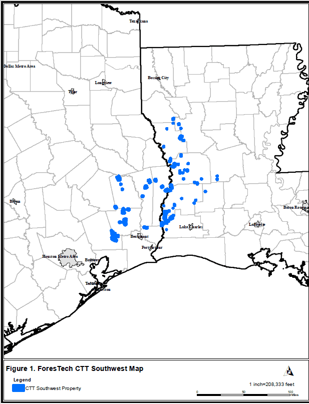
ForesTech International (FTI) was retained by Forest Investment Associates (FIA) to design and conduct a verification inventory on the CTT Southwest property located in Louisiana and Texas. The CTT Southwest property is located centrally between Beaumont, TX and Natchitoches, LA and consists of +/- 55,702 acres (Figure 1). FTI was tasked with designing an inventory to target the property total value within the allowable error (AE) target of 5%. The approach that FTI felt would achieve the desired statistics targets and time constraints motivated our decision to perform a two-stage list sample. A total of 8 strata were created to accurately quantify attributes such as origin, age class, thin classification, and species group. Overall, the inventory project will sample 242 stands (5,496 plots over 13,706 acres).
STRATIFIED TWO-STAGE LIST SAMPLING
Stratified two-stage list sampling is a cost and time efficient sampling scheme that has application for forest level inventories, particularly when time or budget constraints are important. Before discussing stratified two-stage sampling, we will first discuss conventional inventory and then how two-stage sampling differs from conventional inventory.
In a conventional stand inventory, sample plots are established, typically on a grid across the stand area, and tree attributes (i.e. dbh, species, tqi, stopper heights, total heights, etc.) are measured on the plots. The volume or other attributes needed for the trees measured at those plots are used to estimate the volume per acre represented at that location in the stand. The average of those volumes per acre at the sample plots represents the estimated volume per acre in the stand. The assumption, often not explicitly stated, is that the plots selected represent the average conditions found throughout the stand and therefore their average is an accurate estimate of the average volume per acre in the stand. For a conventional forest inventory, each stand receives an inventory from which an average volume per acre and total volume based on the measured plot values within the stand are calculated. To get an estimate of the forest total, the stand total volume estimates are simply added since every stand has an estimated total volume. It should be noted that there is no requirement that each stand be inventoried the same way.
Two-stage sampling involves selecting stands first (“primaries”) and then within the selected stands a conventional inventory is conducted by putting in a grid of sample plots and measuring tree attributes of interest on these plots. The plots are called “secondaries” in the sampling literature since they are only chosen and installed in the selected primaries. The estimated average volume/value per acre and total volume for the stand are obtained in exactly the same way as for conventional inventory. The only problem is that it is not possible to add all the stand estimates to obtain the forest level estimate because every stand does not have an estimate (not every stand had plot/points installed in it). The assumption being made is that the stands selected for the inventory as primaries represent the average condition of stands in the forest. Thinking back to conventional inventory, this is exactly the same intuitive logic used to estimate stand averages from plots. The assumption there is that the plots chosen within a stand represent the average condition of the stand. With two-stage sampling the assumption is that the stands chosen within the forest represent the average condition of the forest.
While all of this sounds logical in theory, how well has it worked in practice? It has actually worked very well. Borders et al. (2005) provided a framework and example from actual inventory comparing conventional and two-stage sampling. This Southern Journal of Applied Forestry article was peer reviewed and provided added detail to the textbook discussion on two-stage sampling in Shiver and Borders (1996). Their discussion was a refinement of two-stage sampling published by Cochran (1977) and DeVries (1986). The idea of inventorying in the manner being described here has been thoroughly reviewed in the forestry sampling literature and found to be sound.
The CTT Southwest property of roughly +/- 55,702 acres, is located in southern Louisiana and Texas with a geographic distribution across fifteen counties. In this case, an accurate forest level estimate is needed in a short time and it would be difficult to physically go to every stand and sample it within the desired time constraints. In regular two-stage sampling, primaries are selected at random. This means that large stands and small stands have the same chance of appearing in the sample. While it is possible to obtain a sample of stands that is representative of the forest using random sampling, it takes a larger sample of stands to ensure a representative sample. Borders et al. (2005) discuss the disadvantages of such a sampling scheme on the first page of their article. Fortunately most forest landowners keep an information database for their properties in which they have relatively recent acreage, stand type, product volume estimates, etc. This data, which exists for the CTT Southwest property, allows for an inventory design that takes advantage of this information.
A two-stage list sample is a specific application of two-stage sampling that replaces the random sampling with sampling in which the larger “size” stands have a greater probability of being included in the first stage (where primaries or stands are chosen) than smaller “size” stands. Size can refer to acres or if another stand characteristic that is correlated with size may be calculated, the probability may be in proportion to those values. In the case of the CTT Southwest property, the estimated total value of each stand was calculated by applying realistic stumpage rates (Table 1) to the product volumes per acre to get an estimated value per acre and then multiplying by the acres to obtain an estimate of total stand value. With list sampling, the stands are placed in a list and are selected from the list with probability proportional to their total value.
Table 1. FIA Market Inventory Product Specifications and Stumpage Prices
Planted Stands | |||||||
Product | Min DBH | Max DBH | Min. Length | Top Dob | Height Meas. | Topwood | Stumpage |
PTOP | - | - | - | 3.0 | Total | No | $ [***] |
PPWD | 3.6 | 21.6 | 21.0 | 3.0 | Total | No | $ [***] |
PCNS | 8.6 | 11.6 | 20.0 | 5.0 | Total | Yes | $ [***] |
PSAW | 12.6 | - | 17.0 | 8.0 | Total | Yes | $ [***] |
HTOP | - | - | - | Total | No | $ [***] | |
HPWD | 4.6 | 21.6 | 20.0 | 4.0 | Total | No | $ [***] |
HSAW | 12.6 | 17.0 | 9.0 | Total | No | $ [***] | |
Natural Stands | |||||||
Product | Min DBH | Max DBH | Min. Length | Top Dob | Height Meas. | Topwood | Stumpage |
PTOP | - | - | - | 3.0 | Total | No | $ [***] |
PPWD | 3.6 | 21.6 | 21.0 | 3.0 | Total | No | $ [***] |
PCNS | 8.6 | 11.6 | 20.0 | 5.0 | Total | Yes | $ [***] |
PSAW | 12.6 | - | 17.0 | 8.0 | Total | Yes | $ [***] |
HTOP | - | - | - | Total | No | $ [***] | |
HPWD | 4.6 | 21.6 | 20.0 | 4.0 | Total | No | $ [***] |
HSAW | 12.6 | 17.0 | 9.0 | Total | No | $ [***] | |
It should be noted that even though more valuable stands have a higher probability of selection to be inventoried, this does not imply that the estimate of total value will be biased upward. In fact, the estimator used in this sampling procedure produces unbiased estimates of value. De Vries (1986) and Cochran (1977) both show proof that the estimator is unbiased. This is similar to another estimator that foresters commonly use. Within a stand, foresters often use point sampling. Point sampling selects trees with probability proportional to their basal areas. Larger trees have a higher probability of selection than smaller trees. This allows foresters to focus their time on measuring mostly larger, more valuable trees. In stands with a wide diameter distribution this results in a more efficient inventory. The resulting point sampling estimators also produce unbiased estimates.
The ability of a two-stage sample to produce accurate estimates depends on choosing stands that represent the average condition of the forest. Partitioning the forest into more uniform strata to select stands that represent the average of the stratum should logically allow for more efficient sampling. Stratifying also allows for different sampling intensities within strata that can later be combined into an overall forest level estimate. Stratification with two-stage list sampling is discussed in Borders et al. (2005) and in Shiver and Borders (1996).
When conducting a two-stage stratified list sample, the first operation is to remove any stands that will not be part of the inventory. This may include pre-merchantable stands. For the CTT Southwest property, removal of stands that did not have significant merchantable volume was the first step. This resulted in 638 stands covering 26,519 acres. This defines the “forest” for this sampling design.
Page 8 of 8
The second step when conducting a two-stage stratified list sample is to define strata. While strata definitions are somewhat arbitrary, they should be chosen with an objective of forming more consistent sets of stands than what would be present in the forest as a whole. For the CTT Southwest property 8 strata were defined (Table 2).
Table 2. Strata Descriptions for inventory of CTT Southwest property
StrataOrder | Description |
1 | PPN_UT_15-19 consisted of all unthinned pine plantations age 15 to 19 |
2 | PPN_TH_15-19 consisted of all thinned pine plantations age 15 to 19 |
3 | PPN_UT_20-24 consisted of all unthinned pine plantations age 20 to 24 |
4 | PPN_TH_20-24 consisted of all thinned pine plantations age 20 to 24 |
5 | PPN_UT_25+ consisted of all unthinned pine plantations age 25+ |
6 | PPN_TH_25+ consisted of all thinned pine plantations age 25+ |
7 | NPN_20+ consisted of all natural pine stands age 20+ |
8 | NHD_20+ consisted of all natural hardwood stands age 20+ |
Table 3 shows the general characteristics of these eight strata. Table 4 shows the total value of stands in each stratum as estimated using the CTT Southwest product tons provided in each stand multiplied by the following product prices according to stand origin. Planted pine – pine pulpwood $9/ton, hardwood pulpwood $7.5/ton, pine chip-n-saw $15/ton, pine sawtimber $25/ton, and hardwood sawtimber $21/ton. Natural stands – pine pulpwood $6/ton, hardwood pulpwood $5/ton, pine chip-n-saw $10/ton, pine sawtimber $16.67/ton, and hardwood sawtimber $14/ton. The variance (S^2) for each stratum was estimated from the value per stratum data using equations (3) and (4) of the Borders et al. (2005).
Table 3. General characteristics of the 8 strata on the CTT Southwest property.
Strata | N_Stands | Avg_StandSize | Sum_NetAcres | Avg_ValuePerAcre | ||
PPN_UT_15-19 | 92 | 48 | 4,398 | $1,043 | ||
PPN_TH_15-19 | 47 | 51 | 2,408 | $690 | ||
PPN_UT_20-24 | 14 | 24 | 338 | $1,512 | ||
PPN_TH_20-24 | 31 | 47 | 1,447 | $1,087 | ||
PPN_UT_25+ | 14 | 21 | 288 | $1,704 | ||
PPN_TH_25+ | 88 | 41 | 3,569 | $1,396 | ||
NPN_20+ | 50 | 28 | 1,421 | $756 | ||
NHD_20+ | 302 | 42 | 12,649 | $688 | ||
638 | 26,519 | $1,109 | ||||
Page 9 of 9
Table 4. Estimated total values by stratum and overall and variances of value (S^2) by stratum.
Strata | N_Stands | Sum_TotalValue | S^2 WithinStrata | S^2 OfTotal | ||||||
PPN_UT_15-19 | 92 | $4,272,948 | $174,880 | $36,770,607,716 | ||||||
PPN_TH_15-19 | 47 | $1,554,735 | $65,965 | $8,141,137,114 | ||||||
PPN_UT_20-24 | 14 | $393,900 | $832,031 | $6,805,691,025 | ||||||
PPN_TH_20-24 | 31 | $1,541,574 | $88,087 | $5,947,790,363 | ||||||
PPN_UT_25+ | 14 | $510,491 | $654,467 | $3,881,474,995 | ||||||
PPN_TH_25+ | 88 | $4,874,546 | $316,989 | $45,881,290,043 | ||||||
NPN_20+ | 50 | $1,246,468 | $228,331 | $9,227,466,805 | ||||||
NHD_20+ | 302 | $8,193,714 | $183,442 | $97,178,934,867 | ||||||
638 | $22,588,376 | $213,834,392,928 | ||||||||
The third step in conducting a stratified two-stage list sample is to select primaries in each of the strata. A two-stage list sample was carried out for each of the eight strata. Simulated results were made using the values constructed from the product values assumed and the acreage and product tons in the CTT Southwest database (Table 5). For field inventory sampling efficiency, all stands that fell below the 15 acre minimum threshold were excluded from being selected but will be included in the overall strata totals. Sample sizes were changed as needed to obtain a stratum AE around 20%, if achievable. Some of the smaller sized strata naturally had higher variability within the strata and thus were harder to reduce the AE. For some of the less variable strata, the AE is considerably lower than 20%. It should be noted that the variances used in this inventory design depend entirely on the product values and acreages in the CTT Southwest database. Deviations from those stand product volumes or from the acreages by stand in the actual inventory once conducted will result in deviations from these projected AEs.
Table 5. Simulated results of a two-stage list sample assuming perfect reproduction of acres and product volumes in the CTT Southwest database.
Page 10 of 10
Strata | N_Stands | Sum_NetAcres | SE OfTotal | AE | Sample Value | |||
PPN_UT_15-19 | 54 | 2,907 | 227,549 | 11 | % | $4,245,155.64 | ||
PPN_TH_15-19 | 26 | 1,532 | 124,007 | 15 | % | $1,645,365.75 | ||
PPN_UT_20-24 | 4 | 247 | 220,206 | 82 | % | $535,948.54 | ||
PPN_TH_20-24 | 27 | 1,403 | 76,557 | 10 | % | $1,535,004.76 | ||
PPN_UT_25+ | 5 | 240 | 89,570 | 35 | % | $513,743.06 | ||
PPN_TH_25+ | 50 | 3,358 | 239,103 | 9 | % | $5,057,323.04 | ||
NPN_20+ | 18 | 986 | 104,718 | 18 | % | $1,195,646.57 | ||
NHD_20+ | 58 | 3,034 | 562,722 | 13 | % | $8,446,548.04 | ||
242 | 13,706 | $23,174,735 | ||||||
Note the advantages for obtaining an efficient estimate. Even though there are 638 stands in the forest, only 242 of them (about 38% of stands but 52% of the area in acres) will be inventoried. Though only one third of all stands will be inventoried, over half the acreage (13,706 out of 26,519) will be inventoried. The stands chosen for selection contain a total estimated value of $13,206,632 of the estimated $22,588,376 total in all stands. This emphasizes the efficiency of list sampling in placing plots in stands that are more important to obtaining a good estimate of the total value by sampling higher value stands with higher probability. These stratum totals are not of particular interest in and of themselves. They were rather arbitrarily chosen and the AE for the totals only serves as a barometer of how well the inventory within each stratum estimates the stratum total. The variance of the total for each stratum is added to obtain the variance of the forest total. The square root of this value is the standard error of the estimate of the forest total and is used in estimating the realized allowable error (RAE). For this simulation the RAE was about 6%. Again, it cannot be overemphasized that changes in product tons within the selected stands to be inventoried in the actual inventory versus the values in the database along with changes in acres can change the RAE in the actual inventory significantly. However, in the absence of other data from which to design the inventory, the data provided must be assumed to be reasonably accurate until proven otherwise.
The fourth step in conducting a stratified two-stage list sample is to assign plots (secondaries) in each of the chosen stands (primaries). The actual inventory intensity within each selected primary for the CTT Southwest project varies by stratum. All strata will be inventoried using a predetermined basal area factor to target a minimum 6 tree average per plot. Planted pine stands age 25 and greater (PN_TH_25+ and PPN_UT_25+) will have a cruise intensity of 1 plot per 2 acres with a minimum of 20 plots per stand and a maximum of 40 plots per stand. Planted pine stands 15 to 20 years of age (PPN_UT_15-19, PPN_TH_15-19, PPN_UT_20-24 and PPN_TH_20-24) will have a cruise intensity of 1 plot per 3 acres with a minimum of 20 plots per stand and a maximum of 40 plots per stand. Natural pine and hardwood stands will have a cruise intensity of 1 plot per 5 acres with a minimum of 15 plots per stand and a maximum of 40 plots per stand. The result is 5,496 points (Table 6). Points will be installed by FTI according to the
Page 11 of 11
inventory cruise specifications and instructions (FIA_CTT_Southwest_Inventory_Specifications_20180906.pdf).
A subsample of points will be audited by FTI personnel to ensure inventory foresters adhere to the cruise specifications and quality expectations. The audit parameters are also included in the inventory cruise specifications. Data will be compiled and estimates calculated by estimating product volumes through FTI’s SiMS system. It will be possible to evaluate pre-inventory database values versus inventory estimates for each of the 242 stands selected if that is desired.
Table 6. Inventory selected stands summary by Strata.
Strata | N_Stands | N_Plots | N_NetAcres |
PPN_UT_15-19 | 54 | 1,272 | 2,907 |
PPN_TH_15-19 | 26 | 607 | 1,532 |
PPN_UT_20-24 | 4 | 100 | 247 |
PPN_TH_20-24 | 27 | 616 | 1,403 |
PPN_UT_25+ | 5 | 124 | 240 |
PPN_TH_25+ | 50 | 1,480 | 3,358 |
NPN_20+ | 18 | 316 | 986 |
NHD_20+ | 58 | 981 | 3,034 |
242 | 5,496 | 13,706 | |
Two-stage stratified list sampling is an efficient inventory method when the objective is an estimate of forest level value. It does not provide an estimate of every stand, but in many acquisition situations the overall value is the value needed. This efficient sampling design should be more widely used in acquisition inventories.
INVENTORY VERIFICATION CRITERIA
The inventory verification results will be compiled as follows:
Step 1: Estimate the Stand Level Volume for the Cruised Stands:
The raw data from the field will be imported into FTI’s SiMS system for the cruise workup (Appendix 1. SiMS2012_SystemInfo_20180906.pdf). The inventory design product specifications for pine and hardwood will be utilized from earlier in document (Table 1). Tons by product will be estimated for each tree in the raw data and expanded to a per acre basis for each point. Estimated product tons per acre for each stand will be calculated using the standard methodology for point samples. The tons per acre will be multiplied by the acres to determine the total stand level volumes.
Step 2: Within Each Strata, Compare the Total Value of Cruised Stands to the Total Estimated Value of Cruised Stands based on Seller Data
For each stand the total volumes for the cruised stands will be multiplied by the unit values from the value table to determine the verification value of cruised stands. Within each strata, this value will be summed for all cruised stands and this value will be compared to the estimated value of cruised stands based on seller’s volume data to determine a percent difference for each strata. Baseline values were estimated from the seller provided volumes expanded by acres and stumpage prices for a property level value of $22,588,376 (Table 7).
Table 7. Property level summary values by products and values for the CTT Southwest Property.
Products | Tons | Value |
PTOP_T + PPWD_T | [***] | $ [***] |
PCNS_T | [***] | $ [***] |
PSAW_T | [***] | $ [***] |
ALL PINE | [***] | $ [***] |
HPWD_T | [***] | $ [***] |
HSAW_T | [***] | $ [***] |
ALL HARDWOOD | [***] | $ [***] |
ALL TONS | [***] | $ [***] |
Step 3: Expand the Value Comparison for the Cruised Stands within Each Strata to the Entire Strata:
For each strata, the Percent Difference for the cruised stands within the strata will be applied to all stands included within the strata. For example, if the verification value of cruised stands for the 50 stands cruised in the PPN_TH_25+ is found to be 108% of the
estimated value for the same 50 stands using seller data, then a 108% value adjustment will be applied to all of the 88 stands within this strata. (At the strata level, these adjustments will be applied without regards to the 3% threshold that will be used for the overall comparison).
Step 4: Sum the Strata Level Results to get the Timber Verification Inventory Value of the Property:
All eight strata will be compiled using the same methodology for adjustment. The sum of these adjusted values for the eight strata will be the Timber Verification Inventory Value. The Timber Verification Inventory Value for all stands will be compared to the Total Estimated Merchantable Timber Value from the value table to determine the purchase price adjustment, if required.
Borders, B. E., B. D. Shiver, and M. L. Clutter. 2005. Timber Inventory of Large Acreages
Using Stratified Two-Stage List Sampling. South. J. Appl. For. 29(3): 152-157.
Cochran, W. G. 1977. Sampling techniques, 3rd Edition. John Wiley & Sons, New York, 428 p.
DeVries, P. G. 1986. Sampling theory for forest inventory. Springer-Verlag, New York. 399 p.
Shiver, B. D. and B. E. Borders. 1996. Sampling techniques for forest inventory. John Wiley &
Sons, New York, 356 p.

FIA INVENTORY VERIFICATION
CRUISE INSTRUCTIONS
SEPTEMBER 6, 2018
PREPARED BY:
FORESTECH INTERNATIONAL
P.O. BOX 1819
WATKINSVILLE, GEORGIA 30677
Table of Contents
Cruise17
INVENTORY
Overall objectives are to provide stand level assessments and to collect accurate plot and tree level data. ForesTech (FTI) provides digital copies of location maps (e.g. overview map, tract maps, and stand maps) and shapefiles. Inventory foresters are expected to record plot and tree level data using TCruise software. FTI provides the TCruise templates (TCC files). Stand level assessments will be recorded using the provided Microsoft Excel template (FTI_Stand_Template.xlsx). Contractors must use a GPS device to navigate to pre-numbered plots using the coordinates provided by FTI.
The document defines cruise design, stand level data to summarize, plot attributes and tree measurements to capture at each sample point, and how to handle plot irregularities. Screenshots of the TCruise templates, limiting distance tables, tree measurement diagrams, and audit expectations are provided.
Cruise Design
• | Sampling Intensity - Excel document, StandLister.xlsx, provides detail for individual stands. |
• | Sampling Protocol |
a. | All stands within a strata must use the same prism throughout strata, no exceptions. |
Strata | StrataOrder | PlotType | PlotSize |
PPN_UT_15-19 | 1 | BAF | 20 |
PPN_TH_15-19 | 2 | BAF | 10 |
PPN_UT_20-24 | 3 | BAF | 20 |
PPN_TH_20-24 | 4 | BAF | 15 |
PPN_UT_25+ | 5 | BAF | 20 |
PPN_TH_25+ | 6 | BAF | 15 |
NPN_20+ | 7 | BAF | 15 |
NHD_20+ | 8 | BAF | 15 |
• | DBH |
a. | Tally ALL PINE 3.6” (4” class) and greater in 1” DBH classes |
b. | Tally ALL HARDWOOD 4.6” (5” class) and greater in 1” DBH classes |
• | Tree Quality Index (TQI) - TQI (1, 3, or 4) will be utilized to determine a stem’s future potential. |
• | Height Measurements |
a. | PINE - Total height to nearest foot. Minimum of 30 total heights (minimum of two per plot) per stand to be measured. This includes one site index tree per plot. |
b. | HARDWOOD - Heights measurements to 4” top to nearest foot. All hardwood stems tallied require a 4” top height. No hardwood site trees to be measured. |
• | Stopper Heights (sawtimber and pulpwood) - Each stem should be assessed for stoppers. Measure stoppers to nearest foot interval for all trees. |
a. | Minimum Lengths |
i. | Sawtimber potential stems |
1. | Pine - Each tallied tree should have a minimum of 16’ of clear log in the first 24’ and have sawtimber potential. |
2. | Hardwood - Each tallied tree should have a minimum of 16’ of clear log (above butt swell). |
ii. | Always pulpwood stems - No minimum length required. No sawtimber stopper allowed. |
DATA DELIVERY
Completed data to be uploaded daily. FTI will only accept completed stands. A “Dropbox” account will be available to upload completed data sets.
File naming: StandName_PlotType&PlotSize_CruiserInitials_PlotCount.tce
Example: BD7061-0338_BAF 15_RDC_48.tce
Example: BD7061-0338_BAF 15_RDC_48.tce
Data submissions to include:
• | TCD and/or TCE files |
• | Stand Template Excel spreadsheet (FTI_Stand_Template.xlsx) - Professional comments for each stand are required for payment. |
• | Completed stand maps (only ones with annotations). |
• | Waypoint file. |
From time to time cruisers are given options on sample sizes (e.g. BAF 10, 15 or 20) for different stand types; therefore, FTI has applied three (3) ways to assure that the correct sample size is being identified for processing.
1. | The cruiser selects the appropriate TCruise TCC file. The parameters are set to the BAF selection that the cruiser chooses. |
2. | The TCE file name includes the plot type and plot size in its title. |
3. | The Microsoft Excel Template is completed by the cruiser after the stand is inventoried and the cruiser fills in the plot type and plot size used. |
A work order will be provided that details zip folder names for uploaded files. If maps cannot be sent electronically, please mail them to:
ForesTech International
1800 Hog Mountain Road
Building 600, Suite 101
Watkinsville, GA 30677
1800 Hog Mountain Road
Building 600, Suite 101
Watkinsville, GA 30677
GENERAL INSTRUCTIONS
Navigation
Inventory foresters are required to use GPS navigation to locate sample plots. A 33 foot tolerance from desired plot location is allowed. For sample points outside tolerance, cruisers are required to record and provide new coordinates for purposes of relocation.
With different navigation software (SOLO Forest) and hardware available, FTI require inventory foresters to use available versions that log exact coordinates where the sample plot is taken.
Plot Monument
Orange or pink vinyl flagging (fluorescent) is requested to be used in this cruise. Identify the exact plot center with a ground flag by exposing bare soils and staking a flag in the ground leaving 12”-18” left visible (pin flags are the preferred marking method for centers but ground flags are acceptable if installed appropriately). Tie a vertical flag at eye-level or higher as close to plot center as possible. Write cruiser initials (3 letters) and point number on the vertical flag. (Ex: RDC 100) Failing to correctly monument point (i.e. missing or inadequate flagging) can result in deductions during an audit.
• | Plantations: |
a. | Double-band one dominant/co-dominant tree on the plot to represent a site index tree. Tree selected should be the dominant species in the stand and represent the stand age. Use this tree as the first tally tree. |
b. | Single-band additional pine trees to represent height trees. These trees should also be the dominant species and represent the stand age. |
• | Natural Stands: |
a. | Double-band one dominant/co-dominant pine tree on the plot to represent a site index tree. Tree selected should be the dominant pine species in the stand and representative of the stand age. If no pine is available then double-band a dominant/co-dominant crown class tree as close to plot center as possible. Use the double banded tree as the first tally tree on the plot. |
b. | Identify additional pine height trees in natural stands with a single band of flagging. No need to identify hardwood trees with flagging (unless tally begins with a hardwood tree). |
• | Clockwise Tally: |
a. | After recording the first measured tree (identified with double flagging), move in a clockwise manner around the plot recording tree data. |
b. | If a tree is tallied out of order, please note in the TNote box with “ooo” to signal that the tree was tallied out of order. |
Plot Type and Plot Size
Cruisers should load the appropriate TCC file for the intended plot type and size of the stand to be inventoried. Note, TCC parameters are reflected in their respective names (origin, plot type, plot size) and should be loaded for each stand individually (i.e. each stand should have its own TCC file loaded). Once a TCC file is loaded, cruisers should rename and save the file to reflect the stand that is being inventoried. Refer to page 2 of this document for file naming.
FTI stand maps provide history detail with the intended plot type and plot size; however, stand history may not be current. For example, an expected unthinned plantation has been recently thinned. Furthermore, the unexpected thinned plantation needs to be updated in the Excel template that accompanies the TCE file submitted.
Both fixed radius and prism plots are utilized.
Table 1. Sampling protocol for intended strata type.
Strata | StrataOrder | PlotType | PlotSize |
PPN_UT_15-19 | 1 | BAF | 20 |
PPN_TH_15-19 | 2 | BAF | 10 |
PPN_UT_20-24 | 3 | BAF | 20 |
PPN_TH_20-24 | 4 | BAF | 15 |
PPN_UT_25+ | 5 | BAF | 20 |
PPN_TH_25+ | 6 | BAF | 15 |
NPN_20+ | 7 | BAF | 15 |
NHD_20+ | 8 | BAF | 15 |
*No minimum tree requirement for BAF 10.
For a variable radius plot, the limiting distance is calculated using the tree’s DBH and a plot radius factor (PRF). This measured distance is compared to the calculated limiting distance (DBH*PRF) for that tree. If the measured distance is less than or equal to the limiting distance, then the tree is counted. Refer to Appendix for limiting distance tables. To determine if a candidate tree is in or out of a both plot types, the cruiser measures the horizontal distance from the plot center to the tree’s pith.
Table 2. Basal area factor and corresponding plot radius factor to determine limiting distance calculations.
Basal Area Factor | Plot Radius Factor |
10 | 2.750 |
15 | 2.245 |
20 | 1.944 |
Limiting distance (feet) = Diameter Breast Height (DBH inches) * PRF
If slope is encountered and influences plot sampling then refer to Table 3 for critical distance measurements.
Table 3. Slope Correction Table
% Slope | Correction Factor | % Slope | Correction Factor | % Slope | Correction Factor |
10 | 1.005 | 45 | 1.097 | 80 | 1.281 |
15 | 1.011 | 50 | 1.118 | 85 | 1.312 |
20 | 1.020 | 55 | 1.141 | 90 | 1.345 |
25 | 1.031 | 60 | 1.166 | 95 | 1.379 |
30 | 1.044 | 65 | 1.193 | 100 | 1.414 |
35 | 1.059 | 70 | 1.221 | ||
40 | 1.077 | 75 | 1.250 | ||
Example:
BAF = 10
DBH = 20.0
Slope = 20%
Slope Corrected Plot Radius Factor | = Slope Correction Factor * Plot Radius Factor = 1.020 * 2.750 = 2.805 |
Limited Distance | = Slope Corrected Plot Radius Factor * DBH = 2.805 * 20.0 = 56.1 feet |
Stand Level Data
Stand level data will be recorded in a separate Microsoft Excel template provided in the cruiser’s project folder. The template is to summarize the stand, post-cruise. Cruisers should verify a stand’s cover type, stand lines, non-productive areas, age, etc. Any discrepancies or issues should be notated on the stand maps as well as noted in the Stand Template ‘Comments’ field (FTI_Stand_Template.xlsx). Stand maps should be submitted if edits are necessary.
The Stand Template is a required submission and is needed for processing. DATA SUBMISSIONS ARE INCOMPLETE WITHOUT STAND TEMPLATE AND ARE REQUIRED FOR PAYMENT. Most cells can be filled using the drop down selections. FTI requires stand comments. The ‘Comments’ field is intended for cruisers to expand on what was seen in the field. Even if the stand is “normal”, commenting about a stand’s overall health and tree form within the stand is good information to pass along. Noting crown development, site conditions, access roads, insect damage, thinning potential, understory species, logging damage, site cleanup, SMZ’s, etc. are beneficial to forest management. Each column heading in the Stand Template is further explained below. (Figure 1)
Stand Level Attributes recorded in Microsoft Excel template
ID | StandID | CruiseDate | Cruiser | Stand Type | PlotType | PlotSize | N_Plots | Comments | GISEdits |
1 | T20120-0050 | 2/27/2017 | FTI-MAA | Natural - Unthinned | BAF | 15 | 25 | The stand was totally flooded. Coul | No |
2 | T20120-0973 | 2/27/2017 | FTI-MAA | Planted - Thinned | BAF | 10 | 11 | Trees look good, however, the stand | No |
3 | T20120-0969 | 2/27/2017 | FTI-MAA | Planted - Thinned | BAF | 20 | 12 | Trees look good, however, the stand | No |
4 | T11210-0402 | 3/1/2017 | FTI-MAA | Natural - Unthinned | BAF | 15 | 5 | Stand is very steep, hard to access, | No |
5 | T11210-0503 | 3/1/2017 | FTI-MAA | Natural - Unthinned | BAF | 15 | 5 | Beautiful stand, park like, very tall | No |
6 | T11456-0202 | 3/1/2017 | FTI-MAA | Planted - Thinned | BAF | 15 | 3 | Small stand, harvested really close | No |
Figure 1. Example stand data entry in Stand Template.
• | ID - Denotes entry number. |
• | Stand ID - StandName. |
• | CruiseDate (Cruise Date) - Enter the cruise date for the stand. If the stand is cruised over multiple days, use the last date cruiser visited the stand in the month/day/year format (Ex. 8/28/2018). |
• | Cruiser (Cruiser) - Enter the “contractor-cruiser” abbreviation for the plot. The format is 7 characters total in length. Three character abbreviation for the contractor name and the cruiser’s three initials. Separate contractor and cruiser with a hyphen (Ex: FTI-RDC). If multiple cruisers are within a single stand, enter each cruiser’s 7 character abbreviations separated with a comma (only one stand entry needed). |
• | Stand Type - Select from the drop down menu the stand type cruised: |
• | Planted - Thinned |
• | Planted - Unthinned |
• | Natural - Thinned |
• | Natural - Unthinned |
• | PlotType (Plot Type) - Enter the three letter abbreviation plot type selected for the inventory cruise. (BAF) |
• | PlotSize (Plot Size) -BAF used (10, 15 or 20). |
• | N Plots (Number of Plots) - Enter the total number of inventory plots collected during the cruise. If multiple cruisers are within a single stand, enter only one stand record in spreadsheet and provide the total plot count for the stand. |
• | Comments (Comments) - Enter comments for each stand to provide information for future management. Notes about beetles, access, stand boundaries, dropped plots, poor logging, etc. are all topics worthy of comment. One to two sentences. |
• | GIS Edits - Select ‘Yes’ or ‘No’ to indicate if edits to the shapefiles are needed due to stand delineation issues encountered. Completed stand map is required with data submission if edits are required. |
• |
DATA COLLECTION WITH TCRUISE
Plot Level Data
Cruisers will navigate to a predetermined plot location with a GPS device and locate the plot center. There are two levels of plot data collection in TCruise: plot identification (screen 1) and plot assessment attributes (screen 2).
Plot Identification collected with TCruise (Screen 1)
For inventory foresters using Real Time Inventory, the Plot Info fields will populate automatically once the plot is located within the tolerance desired. For cruisers navigating with alternative GPS hardware, they will need to fill the plot identification fields manually. Template examples of the plot identification are shown in Figure 2 below.
TCruise Plot Info Screen (Screen 1)

Figure 2. TCruise plot information screen (screen 1).
• | Stratum (StandName) - Input the stand number provided in the GIS database from the StandName field for the stand. The StandName is used to map the stand to the GIS database. |
• | Plot ID (Plot identification number) - Enter the appropriate plot identification provided by PCH personnel. The value is this field should only be an integer number, no text or characters are allowed. |
• | Cruiser (Cruiser) - Enter the “contractor-cruiser” abbreviation for the plot. The format is seven (7) characters total in length, including the dash. Three character abbreviation for the contractor name and the cruiser’s three initials. Separate contractor and cruiser with a hyphen (Ex: FTI-RDC). |
• | Custom Info (Plot Attributes) - Opens Screen 2 (Plot Attributes). |
• | OK - Opens Screen 3 (Tree Attributes). |
Plot Level Attributes collected with TCruise (Screen 2)
After the waypoint is logged and identification recorded, the cruiser will assess and select the attributes for each sample point. Refer to Figure 3 for example data entry required. Explanations for each attribute follow. These must be recorded for each sample point before logging tree data.
TCruise Plot Info Screen (Screen 2)

Figure 3. Custom plot info screen. (Screen 2)
• | Plot Status - Indicates plot status/location. Selections other than “Normal” may be necessary when the plot does not conform to normal stand conditions. Please provide a comment in PNote that may help explain a selection that deviates from the default setting “Normal”. |
a. | Normal - (Default) - No attributes in the list apply to the plot. Normal plot location identified and installed. |
b. | Offset - Selection made if the plot had to be moved. For example, a plot may need offsetting for safety reasons. If a plot is intentionally moved outside the 33 feet tolerance, then please provide the reason for the offset and the new location as it relates to the original plot coordinates in PNote. |
c. | Road - Selection for a plot that falls in an unmapped road. Describe road type (e.g. gravel, ATV, etc.) and enter width (in feet) (Ex: “ATV 10FT”) |
d. | Deck - Plot fell in an unmapped deck. Enter approximate rectangular dimensions (in feet). (Ex: “150X200”) |
e. | Cut - Plot fell in an unmapped cut area. Enter approximate rectangular dimensions (in feet). (Ex: “150X200”) |
f. | Beaver - Plot fell in an area affected by beaver activity. |
g. | Sensitive - Plot fell in an unmapped SMZ or plot fell in an area where grades are erodible. |
h. | EndSpecies (Endangered Species) - Plot either included or was in view of an endangered species (includes both flora and fauna). Please comment in PNote. |
i. | Dropped - Plot was not sampled. Notate in PNote and provide a comment in the Stands Excel Template. |
j. | Other - Category used if none of the above apply. Please use PNote to explain. |
• | NoTally - Answer the question, “Is this plot a ‘No Tally’?” (Yes or No) (Default ‘No’) |
• | Woody (Woody Competition) - In pine plantations, an evaluation of the woody competition growing on each plot will be assessed (Table 4). Include both pine and hardwood, below the minimum diameter thresholds, in the woody assessment. Note, all stems will be considered woody competition if they fall below the lower diameter threshold for the stand, but certain noncommercial species will always be considered woody competition regardless of diameter size (Appendix H). |
Table 4. Woody competition level assessment.
Comp Level | Measurement |
Low | 0-1 woody competitors per planted tallied stem |
Mod | 2-3 woody competitors per planted tallied stem |
High | 4 or more woody competitors per planted tallied stem |
• | PNote (Plot Note) - Plot comments. |
Tree Level Data
Using the TCruise template (TCC file) selected at the stand level, tree data will be captured. Several attributes will be recorded for each sample tree. Cruisers will identify tree species, measure DBH’s, grade a tree’s future potential using a tree quality index scale, and measure heights. Cruisers will verify and record age for site index trees. Remnant trees are categorized and tallied. Also, when applicable, the cruiser selects a defect from a dropdown menu. Figure 4 shows example tree entries in TCruise. Further discussion about each attribute follows the screenshot.
Tree Level Attributes collected with TCruise (Screen 3)

Figure 4. TCruise tree information screen (screen 3).
• | Spec (Species) - Record species for every tree tallied. Default code is LB (Loblolly Pine). There is no differentiation between Planted and Natural Pine. |
a. | Pine Plantations - Hardwood tally is not species specific, rather tally by group Hard Hardwood (HH) or Soft Hardwood (HS) (Appendix G). |
b. | Natural Stands - There are several natural species selections available in Table 4. However, if a particular hardwood species is not available in the table, please use a group code of Hard Hardwood (HH) or Soft Hardwood (HS) (Appendix G). |
Table 4. Species List.
Pine Species List | |
Code | Species |
LB | Loblolly Pine |
SL | Slash Pine |
LL | Longleaf Pine |
SP | Sand Pine |
VP | Virginia Pine |
SF | Shortleaf Pine |
OP | Other Pine |
Hardwood Species List | |||||||
Code | Species | Code | Species | Code | Species | ||
HH | Hard Hardwood | EL | Elm | SG | Sweetgum | ||
HS | Soft Hardwood | HB | Hackberry | SO | Shumard Oak | ||
AS | Ash | HK | Hickory | SY | Sycamore | ||
BE | Beech | NO | Nuttall Oak | WA | Water Oak | ||
BG | Blackgum | OO | Overcup Oak | WI | Willow Oak | ||
CD | E Red Cedar | OR | Other Red Oak | WL | Walnut | ||
CH | Black Cherry | OW | Other White Oak | WO | White Oak | ||
CO | Cherrybark Oak | PO | Post Oak | WT | Water Tupelo | ||
CY | Cypress | QM | Chestnut Oak | YP | Yellow Poplar | ||
EH | Hemlock | RO | Red Oak | ||||
• | DBH (Diameter Breast Height) - Enter DBH in 1” classes for each tree tallied. Measure and record all pine 3.6” and greater, (4” class). Measure and record all hardwood 4.6” and greater, (5” class). Encountering stem variability is not uncommon when measuring a tree’s DBH. A diagram is included for ways to measure DBH on trees with irregularities (Appendix D). |
• | TQI (Tree Quality Index) - Enter tree TQI (1, 3, or 4) on each tree tallied. (Default ‘1’). Tree Quality Index is assigned to all sample trees. There are three different values which are independent of time, size, or position in the canopy. The purpose of this designation is not only to assess current quality or form but to also consider the future for growing volume as well. Tree Quality refers to the form of the entire tree and is NOT to be confused with log quality. TQI is assigned to each tree based on its potential use now or in the future and is not based on its current size. This is very important to keep in mind as you are determining the appropriate TQI value for a given tree. For example, a very high quality tree that is currently a 6” DBH tree should be assigned TQI = 1 even though it does not currently qualify as sawtimber in the market place. The three different categories used are as follows: |
a. | Tree Quality 1: Sawtimber potential. Tree has good form and quality consistent with producing a sawlog now or within the rotation cycle of the stand. These trees need not be perfect and can contain some minor defects including sweep, crook, knots, etc. A pine stem should have the potential to produce at least one 16 foot log within the first 24 feet of the stem. A hardwood stem should have at minimum 16 feet of clear log above the butt swell. A sawtimber stopper height (SST) should be determined by the cruiser when the sawlog portion of the stem is ‘stopped’ by any single or combination of defects that preclude the stem from being used for sawn material above that point. |
b. | Tree Quality 3: Always pulpwood. These trees have poor quality and/or some type of defect that will limit them to always being a pulpwood product. Using this code will flag the tree as always pulpwood to be utilized for fiber volume only. TQI should not be confused with pulpwood stopper. A TQI 3 code quantifies the entire stem as pulpwood. A pulpwood stopper height (PST) should be determined by the cruiser when one or more defects will preclude the stem from being used for fiber above that defect (e.g. broken top). |
c. | Tree Quality 4: Cull, trees that are not capable of producing any product. These trees usually have extremely poor form or some type of major defect. Cull trees are not dead trees. Do NOT tally dead trees. |
• | HGT (Height) - Enter tree height to the nearest foot. The ‘HGT’ field in the TCruise template will be used to record the height of candidate trees. ‘HGT’ measurements vary based on species (pine or hardwood) (Table 5). The ‘HGT’ field in the TCruise templates will be utilized to accept both the total height measurements for pine and the 4” height measurements for hardwood trees. |
Table 5. Site Tree and Height Tree (HGT) measurements by species and DBH.
Species Group | DBH (in.) | Tree Classification | Num of Height Trees per Plot | |
Site Tree Measurement | Height Tree Measurement | |||
Pine | > 3.6 | Total | Total | See Stand Map |
Hardwood | > 4.6 | NA | 4” DOB* | ALL |
*Refer to Appendix F for 4” top diagram
Stand maps give reference to a number of ‘Height Trees’ to be measured. This number applies to only PINE and informs a cruiser of the number of sample pine heights to measure on each plot. For example, the map for a planted pine stand may state that two (2) ‘Height Trees’ should be collected on each plot. This means, that in addition to the ‘Site Tree’ height measurement, one more height will need to be collected on each plot for a total of two (2) height measurements for each plot. Cruisers should target trees that are relatively straight and free of major defect (i.e. forks and broken tops). Also, Pine ‘Height Trees’ should represent the varying diameter classes represented in the stand.
Note, ‘Height Trees’ does not apply to hardwood trees. All hardwood trees, whether they are in plantations or natural stands, require height measurements. The only time a hardwood tree would not have a height measurement is if it has a TQI value 4, cull.
If a pine tree other than the dominant species in the stand (both plantation and natural stands) is encountered in the plot then the first occurrence of this “Other” pine species requires a height measurement. For example, when cruising a planted loblolly stand a natural shortleaf pine is tallied then a height measurement is required (only the first occurrence).
Stopper Heights
Each sample tree should be assessed for stoppers (sawtimber and/or pulpwood). For example, a pine height tree may require only one height which will be a total height measurement, but a hardwood height tree may have a sawtimber stopper height, a pulpwood stopper height, and a 4” DOB height measured because of a forked bole and excessive branching in the crown (Appendix F).
• | SST (Sawtimber Stopper Height) - Enter height to nearest foot where sawtimber merchantability ends. The material above this point will not be used for solid wood material. The minimum length is 16 feet of usable sawtimber potential in the first 24 feet of the tree. TQI 1 trees may have an SST measurement; however, TQI 3 trees should not have an SST measurement because these trees will never have sawtimber potential. |
• | PST (Pulpwood Stopper Height) - Enter height to nearest foot where pulpwood merchantability ends. The pulpwood stopper height is the height to the nearest foot where material above this point cannot be used for pulpwood (e.g. broken top pines or decurrent branching in hardwood crowns (Appendix F)). TQI 1 trees and TQI 3 trees can both have a PST. |
Site Tree Designation
One PINE site index tree per plot is required in both pine plantations and natural stands. The site index tree chosen should be a dominant or co-dominant crown class sample and represent both the dominant pine species in the stand as well as represent the stand’s age (i.e. not a remnant tree). The tree selected should represent the “site” and preferably free of disease or any major defects (i.e. forks, broken tops, excessive branching, etc.). For all site index trees, record its AGE and its TOTAL HEIGHT in the TCruise template.
Note: The dominant pine species selected for the site tree should be used throughout the stand (i.e. do not mix species for site index trees).
• | Age - Enter age for ONLY the “Site Index Tree” in years. Stand age is represented from the site tree’s age. Planted pine ages will be on the respective stand map and site trees do not need to be cored unless the cruiser disagrees with the age printed. Verify stand age in natural stands as well. |
If the cruiser disagrees with the stand age then coring the site tree at breast height and recording the new age is needed. Please do not replace core in the bore hole, but rather tie the core to the site tree flagging on the trunk. Record site tree ages in the Age field of the TCruise template. A minimum of five (5) site trees will need to be cored for age. Notate in the TNote field of the TCruise template that the tree was cored. Site tree ages on other plots can be estimated.
Note: Recording an age is the only identifier for the Site Index Tree in the template. Please do not omit.
• | Remn - Remnant refers to a pine tree left from a previous harvest. This tree represents an older age class in a planted stand and needs identifying. If tallied, the cruiser classifies this stem in the ‘Remn’ field of the TCruise template with a “Yes” indicator. Indicator is applicable to only pine plantations. |
• | Defect - Select from the list the tree defect that represents the downgrade of the stem or influences a ‘HGT’ measurement (Table 6). Note, for any tree that is “jump/junk butted” record the measurement, in feet, in the TNote column. |
Table 6. Abbreviations for tree defects.
Code | Tree Note | Code | Tree Note |
CR | crook | BT | broken top |
SW | sweep | JB | jump butt |
RU | rust | WH | whorl |
FK | fork | OT | other |
• | TNote - Tree level comment. |
Plot Irregularities
Due to inconsistencies with shapefile stand line edits, cruisers may encounter plots that do not coincide with map layers. Plots may fall entirely out of stand boundaries, in unmapped SMZs, cut areas, etc. We have tried to be proactive and alleviate as much as possible before the inventory but undoubtedly situations will arise. The following examples will answer ways best to handle such encounters; however, if a cruiser gets to an area and cannot determine the best action on how to handle the plot, then please contact ForesTech personnel. With any of these situations, please use your stand maps to notate edits, record new GPS coordinates and use the “Offset” selection in the PlotStatus field of the TCruise template.
Different Forest Type
If sample plots fall in an unmapped area within the stand that is a different forest type than the main stand being cruised, then measure the plots. Use the PNote field to comment as well as make stand map edits. Use the same plot type/size as the main stand.
Unmapped SMZ
Collect the plot where it falls as it relates to an unmapped or mistyped SMZ. These riparian sample areas will be included as valid plots and should not be offset. Use the PNote field to comment as well as make stand map edits. Use the same plot type/size as the main stand.
Plot Falls outside Stand Boundary
If a plot falls clearly outside actual stand boundaries move the plot into the appropriate stand type. Use ‘Offset’ in the PlotStatus field of the TCruise template and record new coordinates if location exceeds the 33 feet tolerance. Move far enough in the stand to not take an edge plot.
Unmapped Utility Corridors / Roads
If a plot falls on the edge or entirely within unmapped transmission lines, ROWs, etc. that are encountered within a stand, then consider these areas as parts of the stand and take the sample plot. Please add a Plot Comment that the plot fell in a utility corridor, etc.
Non-Stocked Areas
If sample plots falls in an area that is non-stocked (including clearcuts), record the plots in the area as ‘No Tally’ plots. Measure all remaining forested plots in the stand. Use the No Tally indicator and the PNote field in the TCruise template to explain. Please monument plot center.
Edge Plots
If a plot falls at the edge of a stand boundary and prevents a plot from being sampled in its entirety, then move the plot to be able to capture a full sample. If the plot needs to be offset by more than the 33 feet allowable tolerance please capture the new GPS coordinates.
Dropped Plots
Drop plots only for safety concerns. Please note why the plot was dropped.
Mistyped Stands
If the entire stand is mistyped, then use the following protocol. Cruisers need to make stand map edits and contact ForesTech with questions if they are uncertain on how to proceed.
Do not cruise
1. | Clearcuts |
2. | If the stand was intended to be a planted stand and turns out to be a natural stand. |
Cruise
1. | If a pine plantation was noted as an unthinned (UT) stand and intended to be cruised but was discovered to be thinned (TH). Document in the Stand Template Excel document. |
2. | If the stand was expected to be a natural stand and turns out to be a planted stand - use cruise protocol for forest type. Consult with FTI for sampling intensity. |
3. | If the stand was a mistyped natural stand. Ex: stand was intended to be a mature Pine Hardwood stand and turns out be a mature Bottomland. |
TCruise Error Checks Setting
In order for TCruise to accept sawtimber stopper height measurements on smaller diameter stems, the error check setting for merchantable height - top should be unchecked. After loading the TCruise template at the stand level, select ‘Opts’ then ‘Error Checks’. Next, deselect ‘Merchantable height - top’ (Figure 5).
TCruise Error Check

Figure 5. TCruise Error Checks setting.
QUALITY CONTROL
Check cruising will follow the scoring system in Table 7. A cruiser’s understanding of the job control document will be scrutinized. Check cruising is to be used as a teaching tool to ensure that the cruise instructions and measurement standards are understood and the data collection is consistent from cruiser to cruiser.
Table 7. Check cruising tolerances for accepting/rejecting a cruiser’s work.
Stand Penalties | Penalty1 | Penalty2 | Tolerance | Measurement | Additional Penalty Comments |
Plot Type and Size Selection1 | 10 | - | - | N/A | None |
Stand Penalties | Penalty1 | Penalty2 | Tolerance | Measurement | Additional Penalty Comments |
Plot Type and Size Selection1 | 10 | - | - | N/A | None |
Plot Flagged Correctly | 5 | - | - | N/A | None |
Woody Comp | 2 | - | 1 | N/A | None |
Stand Penalties | Penalty1 | Penalty2 | Tolerance | Measurement | Additional Penalty Comments |
MissedAdded Tree | 8 | - | 0.3 | feet | None |
SpeciesPenalty | 3 | - | - | species | None |
DBH | 2 | - | 0.4 | inches | None |
TQIPenalty | 1 | - | - | N/A | None |
Missed/Add Saw Stop | 2 | - | 5 | feet | None |
Missed/Add Pulp Stop | 2 | - | 5 | feet | None |
Heights (Pine Site Trees) | 2 | 0.5 | 3 | feet | 0.5*ft outside tolerance |
Heights (All Pine) | 1 | 0.25 | 5 | feet | 0.25*ft outside tolerance |
Heights (Hardwoods) | 1 | 0.25 | 8 | feet | 0.25*ft outside tolerance |
SiteTreeAge | 1 | - | 2 | years | None |
Remn Penalty (Remnant) | 1 | - | - | Indicator variable | None |
1Plot Type and Size Selection - cruiser will be penalized if auditor disagrees with BAF selection. For example, cruiser selected a BAF20 in a thinned pine plantation and not able to average a minimum of 6 trees per plots. The check cruiser felt that a BAF10 should have been selected. Please use the comments in TCRUISE (PNote) to explain your decision process.
2Penalty 2 - this is an additional point penalty that applies if the recorded measurement is out of tolerance. For example, if the check cruise determines that a pine tree height is 10 feet off, the penalty would be 2.25 points. One point for being > 5 feet different plus 1.25 points (10’ - 5’ = 5’ x 0.25 points = 1.25 points).
Stands will be assessed based on a batch of three plots per stand. The total point deduction will be calculated on each plot. Then, the simple average of the point deduction is calculated across the three plot batch. This yields the average point deduction per plot. If there was a stand deduction, it is added to the average point deduction per plot. This yields the total point deduction for the stand. Using a scale of 100, if the total point value in the stand is > 80, the stand passes. Table 8 shows an example calculation. In the example, the average point deduction per plot = 17.2. There was no stand level penalty added, so the total point deduction for the stand = 17.2. The stand would pass since 100 - 17.2 = 82.8 which is > 80.
Table 8. Example Check Cruising Analysis
Stand | Plot | Plot and Tree Penalties |
1 | 1 | 19.3 |
1 | 2 | 24.3 |
1 | 3 | 8.0 |
Average Penalty | 17.2 | |
Stand Level Penalty | - | |
Total Penalty | 17.2 | |
Check cruising is part of a larger quality control effort, which also includes the following:
1. | Sufficient training of all cruisers at the start of a project to ensure that the cruise instructions, measurement standards, and other protocols are understood, and that work will be consistent from cruiser to cruiser. |
2. | Actions in the event of substandard work by any cruiser, including: |
a. | On-site training of cruisers and review of the instructions and protocols. |
b. | Return to cruised plots in the audited stand to redo some or all measurements. |
c. | Removal of a cruiser from the project. |
Work that is deemed as unacceptable will require the check-cruiser to decide how much of the cruiser’s work must be discarded and redone. To minimize the likelihood of rejecting a large amount of work, check cruising will be done frequently, and results will be shared with the cruiser in a timely manner.
In addition to the check cruising, we will also be reviewing the cruise data to determine the following:
1. | Total height measurement distribution across pine tree diameter classes. |
2. | Average number of trees per plot. This will be used to determine if too many or too few trees are being measured. |
3. | Plantation age is consistent with inventory data. |
Appendix A
BAF 10 Limiting Distance Table
Limiting Distance for Tree Inclusion w/ Point Cruising
(BAF 10 Prism in Feet -- Multiplier Value of 2.750)
(BAF 10 Prism in Feet -- Multiplier Value of 2.750)
DBH Tenths of an Inch
DBH | 0 | 0.1 | 0.2 | 0.3 | 0.4 | 0.5 | 0.6 | 0.7 | 0.8 | 0.9 |
0 | 0.0 | 0.3 | 0.6 | 0.8 | 1.1 | 1.4 | 1.7 | 1.9 | 2.2 | 2.5 |
1 | 2.8 | 3.0 | 3.3 | 3.6 | 3.9 | 4.1 | 4.4 | 4.7 | 5.0 | 5.2 |
2 | 5.5 | 5.8 | 6.1 | 6.3 | 6.6 | 6.9 | 7.2 | 7.4 | 7.7 | 8.0 |
3 | 8.3 | 8.5 | 8.8 | 9.1 | 9.4 | 9.6 | 9.9 | 10.2 | 10.5 | 10.7 |
4 | 11.0 | 11.3 | 11.6 | 11.8 | 12.1 | 12.4 | 12.7 | 12.9 | 13.2 | 13.5 |
5 | 13.8 | 14.0 | 14.3 | 14.6 | 14.9 | 15.1 | 15.4 | 15.7 | 16.0 | 16.2 |
6 | 16.5 | 16.8 | 17.1 | 17.3 | 17.6 | 17.9 | 18.2 | 18.4 | 18.7 | 19.0 |
7 | 19.3 | 19.5 | 19.8 | 20.1 | 20.4 | 20.6 | 20.9 | 21.2 | 21.5 | 21.7 |
8 | 22.0 | 22.3 | 22.6 | 22.8 | 23.1 | 23.4 | 23.7 | 23.9 | 24.2 | 24.5 |
9 | 24.8 | 25.0 | 25.3 | 25.6 | 25.9 | 26.1 | 26.4 | 26.7 | 27.0 | 27.2 |
10 | 27.5 | 27.8 | 28.1 | 28.3 | 28.6 | 28.9 | 29.2 | 29.4 | 29.7 | 30.0 |
11 | 30.3 | 30.5 | 30.8 | 31.1 | 31.4 | 31.6 | 31.9 | 32.2 | 32.5 | 32.7 |
12 | 33.0 | 33.3 | 33.6 | 33.8 | 34.1 | 34.4 | 34.7 | 34.9 | 35.2 | 35.5 |
13 | 35.8 | 36.0 | 36.3 | 36.6 | 36.9 | 37.1 | 37.4 | 37.7 | 38.0 | 38.2 |
14 | 38.5 | 38.8 | 39.1 | 39.3 | 39.6 | 39.9 | 40.2 | 40.4 | 40.7 | 41.0 |
15 | 41.3 | 41.5 | 41.8 | 42.1 | 42.4 | 42.6 | 42.9 | 43.2 | 43.5 | 43.7 |
16 | 44.0 | 44.3 | 44.6 | 44.8 | 45.1 | 45.4 | 45.7 | 45.9 | 46.2 | 46.5 |
17 | 46.8 | 47.0 | 47.3 | 47.6 | 47.9 | 48.1 | 48.4 | 48.7 | 49.0 | 49.2 |
18 | 49.5 | 49.8 | 50.1 | 50.3 | 50.6 | 50.9 | 51.2 | 51.4 | 51.7 | 52.0 |
19 | 52.3 | 52.5 | 52.8 | 53.1 | 53.4 | 53.6 | 53.9 | 54.2 | 54.5 | 54.7 |
20 | 55.0 | 55.3 | 55.6 | 55.8 | 56.1 | 56.4 | 56.7 | 56.9 | 57.2 | 57.5 |
21 | 57.8 | 58.0 | 58.3 | 58.6 | 58.9 | 59.1 | 59.4 | 59.7 | 60.0 | 60.2 |
22 | 60.5 | 60.8 | 61.1 | 61.3 | 61.6 | 61.9 | 62.2 | 62.4 | 62.7 | 63.0 |
23 | 63.3 | 63.5 | 63.8 | 64.1 | 64.4 | 64.6 | 64.9 | 65.2 | 65.5 | 65.7 |
24 | 66.0 | 66.3 | 66.6 | 66.8 | 67.1 | 67.4 | 67.7 | 67.9 | 68.2 | 68.5 |
25 | 68.8 | 69.0 | 69.3 | 69.6 | 69.9 | 70.1 | 70.4 | 70.7 | 71.0 | 71.2 |
26 | 71.5 | 71.8 | 72.1 | 72.3 | 72.6 | 72.9 | 73.2 | 73.4 | 73.7 | 74.0 |
27 | 74.3 | 74.5 | 74.8 | 75.1 | 75.4 | 75.6 | 75.9 | 76.2 | 76.5 | 76.7 |
28 | 77.0 | 77.3 | 77.6 | 77.8 | 78.1 | 78.4 | 78.7 | 78.9 | 79.2 | 79.5 |
29 | 79.8 | 80.0 | 80.3 | 80.6 | 80.9 | 81.1 | 81.4 | 81.7 | 82.0 | 82.2 |
30 | 82.5 | 82.8 | 83.1 | 83.3 | 83.6 | 83.9 | 84.2 | 84.4 | 84.7 | 85.0 |
31 | 85.3 | 85.5 | 85.8 | 86.1 | 86.4 | 86.6 | 86.9 | 87.2 | 87.5 | 87.7 |
32 | 88.0 | 88.3 | 88.6 | 88.8 | 89.1 | 89.4 | 89.7 | 89.9 | 90.2 | 90.5 |
33 | 90.8 | 91.0 | 91.3 | 91.6 | 91.9 | 92.1 | 92.4 | 92.7 | 93.0 | 93.2 |
34 | 93.5 | 93.8 | 94.1 | 94.3 | 94.6 | 94.9 | 95.2 | 95.4 | 95.7 | 96.0 |
35 | 96.3 | 96.5 | 96.8 | 97.1 | 97.4 | 97.6 | 97.9 | 98.2 | 98.5 | 98.7 |
36 | 99.0 | 99.3 | 99.6 | 99.8 | 100.1 | 100.4 | 100.7 | 100.9 | 101.2 | 101.5 |
37 | 101.8 | 102.0 | 102.3 | 102.6 | 102.9 | 103.1 | 103.4 | 103.7 | 104.0 | 104.2 |
38 | 104.5 | 104.8 | 105.1 | 105.3 | 105.6 | 105.9 | 106.2 | 106.4 | 106.7 | 107.0 |
39 | 107.3 | 107.5 | 107.8 | 108.1 | 108.4 | 108.6 | 108.9 | 109.2 | 109.5 | 109.7 |
40 | 110.0 | 110.3 | 110.6 | 110.8 | 111.1 | 111.4 | 111.7 | 111.9 | 112.2 | 112.5 |
Appendix B
BAF 15 Limiting Distance Table
Limiting Distance for Tree Inclusion w/ Point Cruising
(BAF 15 Prism in Feet -- Multiplier Value of 2.245)
(BAF 15 Prism in Feet -- Multiplier Value of 2.245)
DBH Tenths of an Inch
DBH | 0 | 0.1 | 0.2 | 0.3 | 0.4 | 0.5 | 0.6 | 0.7 | 0.8 | 0.9 |
0 | 0.0 | 0.2 | 0.4 | 0.7 | 0.9 | 1.1 | 1.3 | 1.6 | 1.8 | 2.0 |
1 | 2.2 | 2.5 | 2.7 | 2.9 | 3.1 | 3.4 | 3.6 | 3.8 | 4.0 | 4.3 |
2 | 4.5 | 4.7 | 4.9 | 5.2 | 5.4 | 5.6 | 5.8 | 6.1 | 6.3 | 6.5 |
3 | 6.7 | 7.0 | 7.2 | 7.4 | 7.6 | 7.9 | 8.1 | 8.3 | 8.5 | 8.8 |
4 | 9.0 | 9.2 | 9.4 | 9.7 | 9.9 | 10.1 | 10.3 | 10.6 | 10.8 | 11.0 |
5 | 11.2 | 11.4 | 11.7 | 11.9 | 12.1 | 12.3 | 12.6 | 12.8 | 13.0 | 13.2 |
6 | 13.5 | 13.7 | 13.9 | 14.1 | 14.4 | 14.6 | 14.8 | 15.0 | 15.3 | 15.5 |
7 | 15.7 | 15.9 | 16.2 | 16.4 | 16.6 | 16.8 | 17.1 | 17.3 | 17.5 | 17.7 |
8 | 18.0 | 18.2 | 18.4 | 18.6 | 18.9 | 19.1 | 19.3 | 19.5 | 19.8 | 20.0 |
9 | 20.2 | 20.4 | 20.7 | 20.9 | 21.1 | 21.3 | 21.6 | 21.8 | 22.0 | 22.2 |
10 | 22.5 | 22.7 | 22.9 | 23.1 | 23.3 | 23.6 | 23.8 | 24.0 | 24.2 | 24.5 |
11 | 24.7 | 24.9 | 25.1 | 25.4 | 25.6 | 25.8 | 26.0 | 26.3 | 26.5 | 26.7 |
12 | 26.9 | 27.2 | 27.4 | 27.6 | 27.8 | 28.1 | 28.3 | 28.5 | 28.7 | 29.0 |
13 | 29.2 | 29.4 | 29.6 | 29.9 | 30.1 | 30.3 | 30.5 | 30.8 | 31.0 | 31.2 |
14 | 31.4 | 31.7 | 31.9 | 32.1 | 32.3 | 32.6 | 32.8 | 33.0 | 33.2 | 33.5 |
15 | 33.7 | 33.9 | 34.1 | 34.3 | 34.6 | 34.8 | 35.0 | 35.2 | 35.5 | 35.7 |
16 | 35.9 | 36.1 | 36.4 | 36.6 | 36.8 | 37.0 | 37.3 | 37.5 | 37.7 | 37.9 |
17 | 38.2 | 38.4 | 38.6 | 38.8 | 39.1 | 39.3 | 39.5 | 39.7 | 40.0 | 40.2 |
18 | 40.4 | 40.6 | 40.9 | 41.1 | 41.3 | 41.5 | 41.8 | 42.0 | 42.2 | 42.4 |
19 | 42.7 | 42.9 | 43.1 | 43.3 | 43.6 | 43.8 | 44.0 | 44.2 | 44.5 | 44.7 |
20 | 44.9 | 45.1 | 45.3 | 45.6 | 45.8 | 46.0 | 46.2 | 46.5 | 46.7 | 46.9 |
21 | 47.1 | 47.4 | 47.6 | 47.8 | 48.0 | 48.3 | 48.5 | 48.7 | 48.9 | 49.2 |
22 | 49.4 | 49.6 | 49.8 | 50.1 | 50.3 | 50.5 | 50.7 | 51.0 | 51.2 | 51.4 |
23 | 51.6 | 51.9 | 52.1 | 52.3 | 52.5 | 52.8 | 53.0 | 53.2 | 53.4 | 53.7 |
24 | 53.9 | 54.1 | 54.3 | 54.6 | 54.8 | 55.0 | 55.2 | 55.5 | 55.7 | 55.9 |
25 | 56.1 | 56.3 | 56.6 | 56.8 | 57.0 | 57.2 | 57.5 | 57.7 | 57.9 | 58.1 |
26 | 58.4 | 58.6 | 58.8 | 59.0 | 59.3 | 59.5 | 59.7 | 59.9 | 60.2 | 60.4 |
27 | 60.6 | 60.8 | 61.1 | 61.3 | 61.5 | 61.7 | 62.0 | 62.2 | 62.4 | 62.6 |
28 | 62.9 | 63.1 | 63.3 | 63.5 | 63.8 | 64.0 | 64.2 | 64.4 | 64.7 | 64.9 |
29 | 65.1 | 65.3 | 65.6 | 65.8 | 66.0 | 66.2 | 66.5 | 66.7 | 66.9 | 67.1 |
30 | 67.4 | 67.6 | 67.8 | 68.0 | 68.2 | 68.5 | 68.7 | 68.9 | 69.1 | 69.4 |
31 | 69.6 | 69.8 | 70.0 | 70.3 | 70.5 | 70.7 | 70.9 | 71.2 | 71.4 | 71.6 |
32 | 71.8 | 72.1 | 72.3 | 72.5 | 72.7 | 73.0 | 73.2 | 73.4 | 73.6 | 73.9 |
33 | 74.1 | 74.3 | 74.5 | 74.8 | 75.0 | 75.2 | 75.4 | 75.7 | 75.9 | 76.1 |
34 | 76.3 | 76.6 | 76.8 | 77.0 | 77.2 | 77.5 | 77.7 | 77.9 | 78.1 | 78.4 |
35 | 78.6 | 78.8 | 79.0 | 79.2 | 79.5 | 79.7 | 79.9 | 80.1 | 80.4 | 80.6 |
36 | 80.8 | 81.0 | 81.3 | 81.5 | 81.7 | 81.9 | 82.2 | 82.4 | 82.6 | 82.8 |
37 | 83.1 | 83.3 | 83.5 | 83.7 | 84.0 | 84.2 | 84.4 | 84.6 | 84.9 | 85.1 |
38 | 85.3 | 85.5 | 85.8 | 86.0 | 86.2 | 86.4 | 86.7 | 86.9 | 87.1 | 87.3 |
39 | 87.6 | 87.8 | 88.0 | 88.2 | 88.5 | 88.7 | 88.9 | 89.1 | 89.4 | 89.6 |
40 | 89.8 | 90.0 | 90.2 | 90.5 | 90.7 | 90.9 | 91.1 | 91.4 | 91.6 | 91.8 |
Appendix C
BAF 20 Limiting Distance Table
Limiting Distance for Tree Inclusion w/ Point Cruising
(BAF 20 Prism in Feet -- Multiplier Value of 1.944)
(BAF 20 Prism in Feet -- Multiplier Value of 1.944)
DBH Tenths of an Inch
DBH | 0 | 0.1 | 0.2 | 0.3 | 0.4 | 0.5 | 0.6 | 0.7 | 0.8 | 0.9 |
0 | 0.0 | 0.2 | 0.4 | 0.6 | 0.8 | 1.0 | 1.2 | 1.4 | 1.6 | 1.7 |
1 | 1.9 | 2.1 | 2.3 | 2.5 | 2.7 | 2.9 | 3.1 | 3.3 | 3.5 | 3.7 |
2 | 3.9 | 4.1 | 4.3 | 4.5 | 4.7 | 4.9 | 5.1 | 5.2 | 5.4 | 5.6 |
3 | 5.8 | 6.0 | 6.2 | 6.4 | 6.6 | 6.8 | 7.0 | 7.2 | 7.4 | 7.6 |
4 | 7.8 | 8.0 | 8.2 | 8.4 | 8.6 | 8.7 | 8.9 | 9.1 | 9.3 | 9.5 |
5 | 9.7 | 9.9 | 10.1 | 10.3 | 10.5 | 10.7 | 10.9 | 11.1 | 11.3 | 11.5 |
6 | 11.7 | 11.9 | 12.1 | 12.2 | 12.4 | 12.6 | 12.8 | 13.0 | 13.2 | 13.4 |
7 | 13.6 | 13.8 | 14.0 | 14.2 | 14.4 | 14.6 | 14.8 | 15.0 | 15.2 | 15.4 |
8 | 15.6 | 15.7 | 15.9 | 16.1 | 16.3 | 16.5 | 16.7 | 16.9 | 17.1 | 17.3 |
9 | 17.5 | 17.7 | 17.9 | 18.1 | 18.3 | 18.5 | 18.7 | 18.9 | 19.1 | 19.2 |
10 | 19.4 | 19.6 | 19.8 | 20.0 | 20.2 | 20.4 | 20.6 | 20.8 | 21.0 | 21.2 |
11 | 21.4 | 21.6 | 21.8 | 22.0 | 22.2 | 22.4 | 22.6 | 22.7 | 22.9 | 23.1 |
12 | 23.3 | 23.5 | 23.7 | 23.9 | 24.1 | 24.3 | 24.5 | 24.7 | 24.9 | 25.1 |
13 | 25.3 | 25.5 | 25.7 | 25.9 | 26.0 | 26.2 | 26.4 | 26.6 | 26.8 | 27.0 |
14 | 27.2 | 27.4 | 27.6 | 27.8 | 28.0 | 28.2 | 28.4 | 28.6 | 28.8 | 29.0 |
15 | 29.2 | 29.4 | 29.5 | 29.7 | 29.9 | 30.1 | 30.3 | 30.5 | 30.7 | 30.9 |
16 | 31.1 | 31.3 | 31.5 | 31.7 | 31.9 | 32.1 | 32.3 | 32.5 | 32.7 | 32.9 |
17 | 33.0 | 33.2 | 33.4 | 33.6 | 33.8 | 34.0 | 34.2 | 34.4 | 34.6 | 34.8 |
18 | 35.0 | 35.2 | 35.4 | 35.6 | 35.8 | 36.0 | 36.2 | 36.4 | 36.5 | 36.7 |
19 | 36.9 | 37.1 | 37.3 | 37.5 | 37.7 | 37.9 | 38.1 | 38.3 | 38.5 | 38.7 |
20 | 38.9 | 39.1 | 39.3 | 39.5 | 39.7 | 39.9 | 40.0 | 40.2 | 40.4 | 40.6 |
21 | 40.8 | 41.0 | 41.2 | 41.4 | 41.6 | 41.8 | 42.0 | 42.2 | 42.4 | 42.6 |
22 | 42.8 | 43.0 | 43.2 | 43.4 | 43.5 | 43.7 | 43.9 | 44.1 | 44.3 | 44.5 |
23 | 44.7 | 44.9 | 45.1 | 45.3 | 45.5 | 45.7 | 45.9 | 46.1 | 46.3 | 46.5 |
24 | 46.7 | 46.9 | 47.0 | 47.2 | 47.4 | 47.6 | 47.8 | 48.0 | 48.2 | 48.4 |
25 | 48.6 | 48.8 | 49.0 | 49.2 | 49.4 | 49.6 | 49.8 | 50.0 | 50.2 | 50.3 |
26 | 50.5 | 50.7 | 50.9 | 51.1 | 51.3 | 51.5 | 51.7 | 51.9 | 52.1 | 52.3 |
27 | 52.5 | 52.7 | 52.9 | 53.1 | 53.3 | 53.5 | 53.7 | 53.8 | 54.0 | 54.2 |
28 | 54.4 | 54.6 | 54.8 | 55.0 | 55.2 | 55.4 | 55.6 | 55.8 | 56.0 | 56.2 |
29 | 56.4 | 56.6 | 56.8 | 57.0 | 57.2 | 57.3 | 57.5 | 57.7 | 57.9 | 58.1 |
30 | 58.3 | 58.5 | 58.7 | 58.9 | 59.1 | 59.3 | 59.5 | 59.7 | 59.9 | 60.1 |
31 | 60.3 | 60.5 | 60.7 | 60.8 | 61.0 | 61.2 | 61.4 | 61.6 | 61.8 | 62.0 |
32 | 62.2 | 62.4 | 62.6 | 62.8 | 63.0 | 63.2 | 63.4 | 63.6 | 63.8 | 64.0 |
33 | 64.2 | 64.3 | 64.5 | 64.7 | 64.9 | 65.1 | 65.3 | 65.5 | 65.7 | 65.9 |
34 | 66.1 | 66.3 | 66.5 | 66.7 | 66.9 | 67.1 | 67.3 | 67.5 | 67.7 | 67.8 |
35 | 68.0 | 68.2 | 68.4 | 68.6 | 68.8 | 69.0 | 69.2 | 69.4 | 69.6 | 69.8 |
36 | 70.0 | 70.2 | 70.4 | 70.6 | 70.8 | 71.0 | 71.2 | 71.3 | 71.5 | 71.7 |
37 | 71.9 | 72.1 | 72.3 | 72.5 | 72.7 | 72.9 | 73.1 | 73.3 | 73.5 | 73.7 |
38 | 73.9 | 74.1 | 74.3 | 74.5 | 74.6 | 74.8 | 75.0 | 75.2 | 75.4 | 75.6 |
39 | 75.8 | 76.0 | 76.2 | 76.4 | 76.6 | 76.8 | 77.0 | 77.2 | 77.4 | 77.6 |
40 | 77.8 | 78.0 | 78.1 | 78.3 | 78.5 | 78.7 | 78.9 | 79.1 | 79.3 | 79.5 |
Appendix D
DBH Measurements

Appendix E
Crown Classes

Appendix F
Estimating 4 Inch Top in Hardwood Trees with Decurrent Branching

Appendix G
Hardwood Groupings
Species | General Species | Type | Species | General Species | Type | |
American Holly | Hard Hardwoods, Other | Hard Hardwood | American Elm | Soft Hardwoods, Other | Soft Hardwood | |
Birch Sp. | Hard Hardwoods, Other | Hard Hardwood | Black Cherry | Soft Hardwoods, Other | Soft Hardwood | |
Black Locust | Hard Hardwoods, Other | Hard Hardwood | Black Willow | Soft Hardwoods, Other | Soft Hardwood | |
Black Oak | Red Oaks, Other | Hard Hardwood | Boxelder | Soft Hardwoods, Other | Soft Hardwood | |
Blackjack Oak | Red Oaks, Other | Hard Hardwood | Cypress | Soft Hardwoods, Other | Soft Hardwood | |
Cherrybark Oak | Red Oaks, Select | Hard Hardwood | Elm | Soft Hardwoods, Other | Soft Hardwood | |
Chestnut Oak | White Oaks, Other | Hard Hardwood | Gray Birch | Soft Hardwoods, Other | Soft Hardwood | |
Chinkapin Oak | White Oaks, Select | Hard Hardwood | Hackberry | Soft Hardwoods, Other | Soft Hardwood | |
Common Persimmon | Hard Hardwoods, Other | Hard Hardwood | Hackberry Sp. | Soft Hardwoods, Other | Soft Hardwood | |
Flowering Dogwood | Hard Hardwoods, Other | Hard Hardwood | Magnolia Sp. | Soft Hardwoods, Other | Soft Hardwood | |
Honeylocust | Hard Hardwoods, Other | Hard Hardwood | Paper Birch | Soft Hardwoods, Other | Soft Hardwood | |
Laurel Oak | Red Oaks, Other | Hard Hardwood | Redbay | Soft Hardwoods, Other | Soft Hardwood | |
Live Oak | White Oaks, Other | Hard Hardwood | River Birch | Soft Hardwoods, Other | Soft Hardwood | |
Northern Red Oak | Red Oaks, Select | Hard Hardwood | Sassafras | Soft Hardwoods, Other | Soft Hardwood | |
Nuttall Oak | Red Oaks, Other | Hard Hardwood | Slippery Elm | Soft Hardwoods, Other | Soft Hardwood | |
Overcup Oak | White Oaks, Other | Hard Hardwood | Southern Magnolia | Soft Hardwoods, Other | Soft Hardwood | |
Pin Oak | Red Oaks, Other | Hard Hardwood | Sugarberry | Soft Hardwoods, Other | Soft Hardwood | |
Post Oak | White Oaks, Other | Hard Hardwood | Sweetbay | Soft Hardwoods, Other | Soft Hardwood | |
Red Mulberry | Hard Hardwoods, Other | Hard Hardwood | Sycamore | Soft Hardwoods, Other | Soft Hardwood | |
Rock Elm | Hard Hardwoods, Other | Hard Hardwood | Willow | Soft Hardwoods, Other | Soft Hardwood | |
Scarlet Oak | Red Oaks, Other | Hard Hardwood | Winged Elm | Soft Hardwoods, Other | Soft Hardwood | |
Shumard Oak | Red Oaks, Select | Hard Hardwood | Yellow Buckeye | Soft Hardwoods, Other | Soft Hardwood | |
Southern Red Oak | Red Oaks, Other | Hard Hardwood | ||||
Swamp Chestnut Oak | White Oaks, Select | Hard Hardwood | ||||
Swamp White Oak | White Oaks, Select | Hard Hardwood | ||||
Sweet Birch | Hard Hardwoods, Other | Hard Hardwood | ||||
Water Oak | Red Oaks, Other | Hard Hardwood | ||||
White Mulberry | Hard Hardwoods, Other | Hard Hardwood | ||||
White Oak | White Oaks, Select | Hard Hardwood | ||||
Willow Oak | Red Oaks, Other | Hard Hardwood | ||||
Noncommercial species to be considered in woody competition assessment.
(Not to be tallied as Hardwood)
Species | General Species | Species | General Species | |
Bamboo | noncommercial | Sparkleberry | noncommercial | |
Gallberry | noncommercial | Tallow Tree | noncommercial | |
Palmetto spp. | noncommercial | Titi | noncommercial | |
Privet | noncommercial | Wax myrtle | noncommercial | |
Redbud | noncommercial | Yaupon | noncommercial | |
Sabal palm | noncommercial | |||
SiMS 2012 Suite of Software Products - Growth Model Documentation
Stand Type Growth Modules Currently Available Within SiMS_2012
Cutover Loblolly Pine (Pinus taeda L.) Plantations (Southeast)
Cutover Loblolly Pine (Pinus taeda L.) Plantations (West Gulf)
Oldfield Loblolly Pine (Pinus taeda L.) Plantations (CRP type stands)
Cutover Slash Pine (Pinus elliottii Engelm) Plantations (Southeast)
Cutover Slash Pine (Pinus elliottii Engelm) Plantations (West Gulf)
Oldfield Slash Pine (Pinus elliottii Engelm) Plantations (CRP type stands)
Longleaf Pine (Pinus palustris Mill.) Plantations
Natural Loblolly Pine (Pinus taeda L.) Stands
Natural Slash Pine (Pinus elliottii Engelm) Stands
Natural Longleaf Pine (Pinus palustris Mill.) Stands
Natural Mixed Pine-Hardwood Stands
Natural Mixed Hardwood Stands
Sand Pine (Pinus clausa) Plantations
Detailed discussion of model architecture along with references is given below for each of the growth modules.
Modeling Architecture
The underlying modeling architecture used in SiMS_2012 products is described as a hybrid modeling system that makes use of the best traits of both whole-stand and individual-tree models. Whole-stand models are used to predict and project estimates of surviving stems/acre, stand dominant height (ft) and stand basal area (ft2/acre). If the user does not have a current estimate of the associated stand table then a stand table is predicted using a Weibull (Bailey and Dell 1973) probability distribution function or percentile-based system developed for the stand type in question. See individual stand type model descriptions below for specific citations. If a stand table is available from a cruise then this stand table is input into the SiMS_2012 system and a projection is made from this beginning stand table using generalized stand table projection methodology of Pienaar and Harrison (1988). This procedure projects from the current stand table condition to the expected future stand table condition such that the projected stand table is compatible with the projected whole stand estimates of stems/acre and basal area/acre. Once a predicted and/or projected stand table is available, a height – diameter function is used to obtain heights for each diameter class. Diameter class volume and/or weight per acre is then obtained using individual tree volume and/or weight equations appropriate for the stand type.
Growth projections for thinned stands are accomplished using the concept of a competition index originally presented by O’Connor (1935) modified by Pienaar (1979) and discussed by Harrison and Borders (1996). This methodology makes use a an “unthinned counterpart” to project growth for thinned stands and assures that projections are logical and reasonable relative to expected development of unthinned stands (the case which is best understood).
Growth responses to cultural treatments such as chemical site preparation (based on expected residual hardwood levels), mechanical site preparation treatments that improve tillage (e.g. ripping, bedding, etc.), herbaceous weed control, woody understory release, level of genetic improvement in seedlings used for plantation establishment, and fertilization are obtained using the approach of Pienaar and Rheney (1995).
This approach makes use of an additive growth response term that is used with whole-stand models for dominant height and stand basal area. This approach is very flexible and, based on ForesTech’s proprietary modifications of Pienaar and Rheney’s (1995) published approach, can be used to model expected stand response for treatments that exhibit different long-term response patterns (e.g. 1: treatments that are expected to show increased growth relative to untreated conditions for some number of years after which the cumulated difference between treated and untreated stands is expected to dissipate, 2: treatments that are expected to show an increased growth rate relative to untreated conditions for some number of years and then maintain the cumulated difference through the rotation). Note that ForesTech personnel have been instrumental in the development of this modeling architecture (which is used in many proprietary models developed by individual forest products companies and organizations) and have modified the approach to be consistent with the best understanding available concerning expected responses to silvicultural treatments used singly and in various combinations. Proprietary modifications that adjust expected treatment responses relative to underlying site quality and expected understory competition levels are also built into the system. All silvicultural treatment adjustments are based on the latest information from studies across the southeastern U.S. (e.g. Martin et al. 1999, Amateis et al. 2000, NCSFNC 2000, Borders and Bailey 2001, Lauer and Zutter, 2001, Martin and Shiver 2002, Martin and Shiver 2002, NCSFNC 2002, Miller et al. 2003).
Individual Stand Type Models
When searching the scientific literature for growth and yield systems for various stand types that are managed in the southern U.S. it is rare to find complete systems that allow for the capability and flexibility to make projections under various types of management. Typically, pieces of complete growth and yield systems are developed and published separately by various individuals and organizations. Such individual growth and yield model components are often times not only published separately by different individuals and organizations but they are calibrated with different data. This “piece meal” model development and publication makes for many problems in implementation and logical growth and yield prediction and projection capability. For example, many models have been developed for dominant height development of loblolly pine plantations in the southern U.S. However, they all exhibit different characteristics and can lead to very different projections of dominant height development for the same stand. Furthermore, when growth projections of various species are made using models taken “as is” from the literature many illogical results can be obtained if one chooses to compare projections for the various stand types. For example, for a given set of stand conditions a model for a longleaf pine plantation may project a stand characteristic such as dominant height or basal area/acre that is totally illogical when compared to what actually happens on the ground in longleaf pine stands and/or when compared to what happens in a loblolly pine stand on a similar site with similar management. This is because both the model form and associated parameter estimates (and hence model behavior) are unique to the data used for model development and calibration. Since data available for model development and calibration are limited to the specific set of conditions represented by the data then many situations exist for which growth projections represent extrapolations of both the model form and the data used to calibrate the model.
Prior to the development of the SiMS_2012 system the problem of illogical projections of individual stands as well as illogical properties of how projections of one stand type relate to other stand types have been ignored. However, with the expertise of ForesTech personnel we have modified base model forms taken from the literature and built a modeling architecture that produces growth and yield projections of individual stands that are logical across a wide array of stand conditions and cultural treatments as well as among
stand types. These proprietary modifications and modeling approaches make the SiMS_2012 system the most powerful and realistic growth and yield simulator available for southern pine stand types.
Literature Cited
Amateis, R.L., J. Liu, M.J. Ducey, and H. Lee Allen. 2000. Modeling response to midrotation nitrogen and phosphorous fertilization in loblolly pine plantations. Southern Journal of Applied Forestry 24(4):207-212.
Bailey, R.L. and T.R. Dell. 1973. Quantifying diameter distributions with the Weibull function. Forest Science19:97-104.
Borders, B.E. and R.L. Bailey. 2001. Loblolly pine – pushing the limits of growth. Southern Journal of Applied Forestry 25(2): 69-74.
Harrison, W.M. and B.E. Borders. 1996. Yield prediction and growth projection for site-prepared loblolly pine plantations in the Carolinas, Georgia, Alabama, and Florida. PMRC Technical Report 1996-1. D.B. Warnell School of Forest Resources. The University of Georgia. Athens, GA. 59pp.
Lauer, D.K. and B.R. Zutter. 2001. Vegetation cover response and second-year loblolly and slash pine response following bedding and pre- and post-plant herbicide applications in Florida. Southern Journal of Applied Forestry 25(2):75-83.
O’Connor, A.J. 1935. Forest research with special reference to planting densities and thinning. Br. Emp. For. Conf. South Africa. 30pp.
Martin, S.W., R.L. Bailey, and E.J. Jokela. 1999. Growth and yield predictions for lower coastal plain slash pine plantations fertilized at mid-rotation. Southern Journal of Applied Forestry 23(1):39-45.
Martin, S.W. and B.D. Shiver. 2002. Impacts of vegetation control, genetic improvement and their interaction on loblolly pine growth in the southern United States – age 12 results. Southern Journal of Applied Forestry 26(1):37-42.
Martin, S.W. and B.D. Shiver, B.D. 2002. Twelve-year results of a loblolly site preparation study in the piedmont and upper coastal plain of South Carolina, Georgia, and Alabama. Southern Journal of Applied Forestry 26(1):32-36.
Miller, J.H., B.R. Zutter, S.M. Zedaker, M.B. Edwards, and R.A. Newbold. 2003. Growth and yield relative to competition for loblolly pine plantations to midrotation – a southeastern United States regional study. Southern Journal of Applied Forestry 27(4): 237-252.
NCSFNC. 2000. Eight-Year Responses of Young Loblolly Pine to Nitrogen, Phosphorus, and Potassium Fertilization. NCSFNC Report No. 45. Dept. of Forestry. North Carolina State Univ., Raleigh, NC.
NCSFNC. 2002 Responses to Nutrient Additions in Young Loblolly Pine Plantations: Regionwide 18 Third Report. NCSFNC Report No. 49. Dept. of Forestry. North Carolina State Univ., Raleigh, NC.
Pienaar, L.V. 1979. An approximation of basal area growth after thinning based on growth in unthinned plantations. Forest Science 25(2): 223-232.
Pienaar, L.V. and W.M. Harrison. 1988. A stand table projection approach to yield prediction in unthinned even-aged stands. Forest Science 34(3): 804-808.
Pienaar, L.V. and J.W. Rheney. 1995. Modeling stand level growth and yield response to silvicultural treatments. Forest Science 41(3):629-638.
Literature for Individual Stand Type Models
Pertinent literature for each stand type available in the SiMS_2012 system is cited below. A short description of the data used for model development is also given. As discussed in detail above, the publications cited below provided individual model components that were combined as necessary and adjusted to develop full growth and yield functionality for each stand type.
Cutover Loblolly Pine (Pinus taeda L.) Plantations (Southeast)
Harrison, W.M. and B.E. Borders. 1996. Yield prediction and growth projection for site-prepared loblolly pine plantations in the Carolinas, Georgia, Alabama and Florida. PMRC Technical Report 1996-1. D.B. Warnell School of Forest Resources. The University of Georgia. Athens, GA. 59pp.
Data are from a total of 805 temporary and permanent sample plots located throughout the lower coastal plain, upper coastal plain and piedmont of North Carolina, South Carolina, Georgia, Florida and Alabama.
Cutover Slash Pine (Pinus elliottii Engelm) Plantations (Southeast)
Pienaar, L.V., B.D. Shiver and J.W. Rheney. 1996. Yield prediction for mechanically site-prepared slash pine plantations in the Southeastern Coastal Plain. PMRC Technical Report 1996-3. D.B. Warnell School of Forest Resources. The University of Georgia. Athens, GA. 57pp.
Data are from a total of 691 temporary plots and 254 permanent plots located in the lower coastal plain of South Carolina, Georgia and north Florida. Additional data come from a regionwide (lower coastal plain) planting density study with 114 installations that has planting densities of 100 to 900 trees/acre that were measured up to 8 times at 3 year intervals beginning at age 5 years.
Old-Field Loblolly Pine (Pinus taeda L.) Plantations (CRP-type stands)
Lenhart, J.D. and J.L. Clutter. 1971. Cubic-foot yield tables for oldfield loblolly pine plantations in the Georgia piedmont. GA For. Res. Council Rep. No. 22. 12pp.
Data are from 226 sample plots distributed throughout the piedmont of Georgia.
Pienaar, L.V. and J.W. Rheney. 1998. An evaluation of the potential productivity of intensively managed pine plantations in Georgia. Final Report of a study funded by The Georgia Consortium for Technological Competitiveness in Pulp and Paper. 41pp.
Data obtained from 37 randomly chosen loblolly pine plantations throughout Georgia established under the Conservation Reserve Program as well as from designed studies associated with the Plantation Management Research Cooperative at the D.B. Warnell School of Forest Resources at the University of Georgia.
Old-Field Slash Pine (Pinus elliottii Engelm) Plantations (CRP-type stands)
Bennett, F.A. 1970. Yields and stand structure patterns for old-field plantations of slash pine. USDA For. Serv. Res. Paper SE-60. 81pp.
Clutter, J.L. and E.P. Jones. 1980. Prediction of growth after thinning in oldfield slash pine plantations. USDA For. Serv. Res. Paper SE-217. Southeast For. Exp. Stn. Asheville, NC. 14pp.
Data for the above two publications are from 212 permanent sample plots distributed through north Florida, south Georgia, southern Alabama and Mississippi.
Pienaar, L.V. and J.W. Rheney. 1998. An evaluation of the potential productivity of intensively managed pine plantations in Georgia. Final Report of a study funded by The Georgia Consortium for Technological Competitiveness in Pulp and Paper. 41pp.
Data from 23 oldfield slash pine plantations established under the Conservation Reserve Program as well as from designed studies associated with the Plantation Management Research Cooperative at the D.B. Warnell School of Forest Resources at the University of Georgia.
Cutover Loblolly Pine (Pinus taeda L.) Plantations (West Gulf)
Baldwin, V.C., Jr. and D.P. Feduccia. 1987. Loblolly pine growth and yield prediction for managed west gulf plantations. USDA For. Serv. Res. Paper SO-236. Southern For. Exp. Station. New Orleans, LA. 27pp.
Data are from 85 unthinned and 167 thinned permanent plots distributed through Louisiana, a single county in southwestern Mississippi and two counties in eastern Texas.
Cutover Slash Pine (Pinus elliottii Engelm) Plantations (West Gulf)
Zarnoch, S.J., D.P. Feduccia, V.C. Baldwin, Jr, and T.R. Dell. 1991. Growth and yield model predictions for thinned and unthinned slash pine plantations on cutover sites in the west gulf region. USDA For. Serv. Res. Paper SO-264. Southern For. Exp. Station. New Orleans, LA. 32 pp.
Data consist of 507 unthinned stand yield observations and 543 thinned stand growth period observations from permanent sample plots distributed in the West Gulf region as well as 530 residual stand observations of post-thinning conditions from permanent sample plots distributed in the West Gulf region.
Longleaf Pine (Pinus palustris Mill.) Plantations
In the SiMS_2012 system a single model is used for longleaf pine plantation growth and yield across the entire southern U.S. Models available in the published literature for planted longleaf pine stands are produce illogical and biologically unreasonable long-term growth projections outside of the limited range of data used to develop available models. Therefore, a study of how longleaf pine growth and yield relates to the growth and yield of slash pine plantations was carried out. Based on the results of this internal study ForesTech has developed a growth and yield system for longleaf pine plantations that are a variation of the slash pine plantation models discussed above. This model produces biologically reasonable growth and yield projections for this stand type. Estimates of per acre yield in terms of volume and/or weight is obtained using the individual tree volume and weight equations cited below.
Baldwin, V.C., Jr., and J.R. Saucier. 1983. Aboveground weight and volume of unthinned, planted longleaf pine on West Gulf Forest Sites. USDA For. Serv. Res. Paper SO-191. Southern For. Exp. Station. New Orleans, LA. 8pp.
Natural Loblolly Pine (Pinus taeda L.) Stands
In the SiMS_2012 system a single model is used for natural loblolly pine stands across the entire southern U.S. Several published and unpublished models were evaluated for extrapolative properties and biological reasonableness. The best model available was developed by Souter (1986) and is cited below.
Souter, Ray Albert. 1986. Dynamic Stand Structure in Thinned Stands of Naturally-Regenerated Loblolly Pine in the Georgia Piedmont. PhD Dissertation. School of Forest Resources, University of Georgia. Athens, GA.
Data come from 71 permanent sample plots located on the Hitchiti Experimental Forest in the Piedmont of Georgia (the Growing Space Study). These research plots were established in 1948 and remeasured six times through 1982. Even though the data used in the development of this model are limited geographically, the models behave very well and produce reasonable growth projections for naturally regenerated loblolly pine stands.
Natural Slash Pine (Pinus elliottii Engelm) Stands
In the SiMS_2012 system a single model is used for natural slash pine stands across the entire southern U.S. The models are based on the publications by Frank Bennett.
Bennett, Frank A. 1970. Variable-density yield tables for managed stands of natural slash pine. USDA For. Serv. Res. Note SE-141. Southeastern For. Exp. Station. Asheville, NC. 7pp.
Data are from 82 permanent sample plots that had initial measurement and one five year re-measurement. Plots were distributed throughout north Florida and southeastern Georgia.
Bennett, Frank A. 1981. Growth and yield in natural stands of slash pine and suggested management alternatives. USDA For. Serv. Res. Paper SE-211. Southeastern For. Exp. Station. Asheville, NC. 8pp.
Data are the same data as in the 1970 paper with additional sample plots for a total of 176 permanent sample plots distributed throughout north Florida and southeastern Georgia.
Natural Longleaf Pine (Pinus palustris Mill.) Stands
In the SiMS_2012 system a single model is used for natural longleaf pine stand growth and yield across the entire southern U.S. Models available in the published literature for natural longleaf pine stands are produce illogical and biologically unreasonable growth projections outside of the limited range of data used to develop available models. Therefore, a study of how natural longleaf pine growth and yield relates to the growth and yield of natural slash pine stands was carried out. Based on the results of this internal study ForesTech has developed a growth and yield system for natural longleaf pine plantations that are a variation of the natural slash pine models discussed above. This model produces biologically reasonable growth and yield projections for this stand type. Individual tree volume and weight equations are those used for planted longleaf stands (see citation for Longleaf Pine Plantations above).
Natural Mixed Pine-Hardwood Stands
There are very few models available for growth and yield of mixed pine-hardwood stands that provide estimates of how pine growth and yield changes relative to the amount of hardwood present in the stand.
The SiMS_2012 system uses models from a recent study in Georgia that provides such capability. All models were evaluated and adjusted as needed to obtain logical and biologically reasonable growth patterns.
Martin, S.W. and G.H. Brister. 1999. A growth and yield model incorporating hardwood competition for natural loblolly pine stands in the Georgia piedmont. Southern Journal of Applied Forestry 23(3):179-185.
Data are from 75 permanent sample plots located in the Piedmont of Georgia.
Natural Hardwood Stands
Very few models exist for growth and yield of natural hardwood stands. Most hardwood projections are made using a simplifying assumption such as hardwood yield is expected to grow at 2 to 3% per year. To obtain more flexibility and perhaps more realistic hardwood stand projections ForesTech has evaluated models from the scientific literature and put them together in a workable and complete growth and yield system.
Bowling, E.H., H.E. Burkhart, T.E. Burk and D.E. Beck. 1989. A stand level growth model for Appalachian hardwoods. Canadian Journal of Forest Research 19:405-412.
Graney, D.L. and P.A. Murphy. 1994. Growth and yield of thinned upland oak stands in the Boston Mountains of Arkansas. Southern Journal of Applied Forestry 18(1):10-14.
Zahner, R. and M.K. Myers. 1984. Productivity of young Piedmont oak stands of sprout origin. Southern Journal of Applied Forestry 8(2):102-108.
Olson, D. J., Jr. 1959. Site index curves for upland oak in the Southeast. USDA Forest Service Research Note SE-125. 2p.
Data are varied. Please see publications for data descriptions.
Sand Pine (Pinus clausa) Plantations
Brendemuehl, R. H. 1981. Options for Management of Sandhill Forest Land. Southern Journal Of Applied Forestry 5(4): 216-222.
Burns, Russell M., and R. H. Brendemuehl. 1969. Yield of a Choctawhatchee Sand Pine Plantation at Age 28. USDA Forest Service Research Note SE-103. 4pp.
Outcalt, Kenneth W. 1986. Stand Density Affects Growth of Choctawhatchee Sand Pine. Southern Journal of Applied Forestry 10(3): 128-131.
McNab, W.H., K.W. Outcalt, R.H. Brendemuehl. 1985. Weight and Volume of Plantation-Grown Choctawhatchee Sand Pine. USDA Forest Service Research Paper SE-252. 44pp.
Data are varied. Please see publications for data descriptions.
Individual-Tree Taper, Volume and Weight
Individual-tree stem profiles and cubic-foot volumes are estimated using a form class based, segmented taper equation described in Clark et.al, 1991. Coefficients are available for most commercial and non-commercial tree species encountered in the southeastern U.S. The coefficients were updated using FIA data in 2001 (Souter and Clark, 2001).
To calculate total-stem and merchantable green weights for individual trees, pound-per-cubic-foot conversion factors are calculated using associated weight and volume tables in Clark et al., 1986 and Clark et al., 1990.
Clark Alexander; Saucier, Joseph R.; McNab, W. Henry. 1986. Total-tree weight, stem weight, and volume tables for hardwood species in the southeast. Georgia Forest Research Paper GF-RP-60. Georgia Forestry Commission. 44 p.
Clark, Alexander; Saucier, Joseph R. 1990. Tables for estimating total-tree weights, stem weights, and volumes of planted and natural southern pine in the southeast. Georgia Forest Research Paper GF-RP-79. Georgia Forestry Commission. 23 p.
Clark, Alexander, III; Souter, Ray A.; Schlaegel, Bryce E. 1991. Stem Profile for Southern Equations for Southern Tree Species. Res. Pap. SE-282. Asheville, NC: U.S. Department of Agriculture, Forest Service, Southeastern Forest Experiment Station. 117 p.
Souter, R.A. and A. Clark III. 2001. Taper and volume prediction in southern tree species. USDA For. Serv. Southern Research Station. FIA Work Unit Administrative Report.
Portions of the exhibit, indicated by the mark “[***],” were omitted and have been filed separately with the Securities and Exchange Commission pursuant to the Registrant’s application requesting confidential treatment pursuant to Rule 24b-2 of the Securities Exchange Act of 1934, as amended.
Exhibit K-2
[***]