Attached files
| file | filename |
|---|---|
| EX-99.3 - PRESS RELEASE DATED JUNE 1, 2017 - Rise Gold Corp. | ex99_3.htm |
| EX-99.2 - COVER LETTER DATED JUNE 1, 2017 - Rise Gold Corp. | ex99_2.htm |
| 8-K - CURRENT REPORT DATED JUNE 5, 2017 - Rise Gold Corp. | form_8-k.htm |
Exhibit 99.1
 |
 |
| Technical Report On The Idaho-Maryland Project |
| Grass Valley California, USA |
Prepared for:
Rise Gold Corp
Prepared by:
Greg Kulla, PGeo., Amec Foster Wheeler Americas Limited
Effective Date: 1 June 2017
Project No.: 194594
IMPORTANT NOTICE
This report was prepared as a National Instrument 43-101 Technical Report for Rise Gold Corp by Amec Foster Wheeler Americas Limited (Amec Foster Wheeler). The quality of information, conclusions, and estimates contained herein is consistent with the level of effort involved in Amec Foster Wheeler’s services, based on: i) information available at the time of preparation, ii) data supplied by outside sources, and iii) the assumptions, conditions, and qualifications set forth in this report. This report is intended for use by Rise Gold Corp subject to the terms and conditions of the contract with Amec Foster Wheeler. Their contracts permit Rise Gold Corp to file this report as a Technical Report with Canadian Securities Regulatory Authorities pursuant to National Instrument 43-101, Standards of Disclosure for Mineral Projects. Except for the purposes legislated under Canadian provincial securities law, any other uses of this report by any third party is at that party’s sole risk.
 | Technical Report on the Idaho-Maryland Project Grass Valley California, USA |
| C o n t e n t s | ||||||
| 1.0 | SUMMARY | 1-1 | ||||
| 1.1 | Introduction | 1-1 | ||||
| 1.2 | Key Findings | 1-1 | ||||
| 1.3 | Property Description and Ownership | 1-3 | ||||
| 1.4 | History | 1-3 | ||||
| 1.5 | Geology and Mineralization | 1-4 | ||||
| 1.6 | Exploration | 1-5 | ||||
| 1.7 | Mineral Resource Estimate | 1-5 | ||||
| 1.8 | Other Relevant Data | 1-5 | ||||
| 1.9 | Interpretation and Conclusions | 1-6 | ||||
| 1.10 | Recommendations | 1-6 | ||||
| 2.0 | INTRODUCTION | 2-1 | ||||
| 2.1 | Terms of Reference | 2-1 | ||||
| 2.2 | Principal Sources of Information | 2-1 | ||||
| 2.3 | Site Visits | 2-2 | ||||
| 2.4 | Effective Date | 2-2 | ||||
| 2.5 | Units, Currencies, and Abbreviations | 2-2 | ||||
| 2.6 | Idaho-maryland Mine Property – Use of Terms | 2-3 | ||||
| 3.0 | RELIANCE ON OTHER EXPERTS | 3-1 | ||||
| 3.1 | Mineral Rights | 3-1 | ||||
| 3.2 | Surface Rights | 3-1 | ||||
| 3.3 | Royalties and Agreements | 3-1 | ||||
| 3.4 | Environmental, Permitting, and Liability Issues | 3-2 | ||||
| 3.5 | Mitchell Chadwick Expertise | 3-2 | ||||
| 4.0 | PROPERTY DESCRIPTION AND LOCATION | 4-1 | ||||
| 4.1 | Property Location | 4-1 | ||||
| 4.2 | Property Description | 4-4 | ||||
| 4.2.1 | Surface Rights | 4-4 | ||||
| 4.2.1.1 | Surface Land Obligations | 4-6 | ||||
| 4.2.1.2 | Land Designation | 4-7 | ||||
| 4.2.2 | Mineral Rights | 4-8 | ||||
| 4.3 | Agreements | 4-15 | ||||
| 4.3.1 | Idaho-Maryland Mine Property | 4-15 | ||||
| 4.3.2 | Mill Site Property | 4-15 | ||||
| 4.4 | Environmental liabilities | 4-18 | ||||
| 4.4.1 | Idaho Land | 4-18 | ||||
| 4.4.2 | Brunswick Land | 4-18 | ||||
| 4.4.3 | Mill Site Land | 4-19 | ||||
| 4.5 | Permits | 4-19 | ||||
| 4.5.1 | Permit Requirements for Surface Exploration Drilling | 4-19 | ||||
| 4.5.2 | Nevada County Noise Regulation | 4-20 | ||||
| Project No.: 194594 | Page i |  |
| | Technical Report on the Idaho-Maryland Project Grass Valley California, USA |
| 4.5.3 | Union Surface Exploration Drill Site | 4-21 | ||||
| 4.5.3.1 | Access and Drill Site | 4-21 | ||||
| 4.5.3.2 | Water Management | 4-22 | ||||
| 4.6 | Additional Details Regarding Permitting | 4-22 | ||||
| 4.6.1 | Nevada County Use Permit and CEQA | 4-23 | ||||
| 4.6.2 | Major Permits Required for an Underground Mine | 4-24 | ||||
| 4.6.3 | Nevada County – Recent Permit Examples | 4-25 | ||||
| 4.7 | Other Significant Risks | 4-26 | ||||
| 5.0 | ACCESSIBILITY, CLIMATE, LOCAL RESOURCES, INFRASTRUCTURE AND PHYSIOGRAPHY | 5-1 | ||||
| 5.1 | Accessibility | 5-1 | ||||
| 5.2 | Climate | 5-1 | ||||
| 5.3 | Physiography | 5-4 | ||||
| 5.4 | Local Resources and Infrastructure | 5-4 | ||||
| 5.4.1 | Surface Rights | 5-5 | ||||
| 5.4.2 | Electrical Power | 5-8 | ||||
| 5.4.3 | Water Supply | 5-8 | ||||
| 5.4.4 | Roads | 5-8 | ||||
| 5.5 | QP Comment | 5-9 | ||||
| 6.0 | HISTORY | 6-1 | ||||
| 6.1 | History of the Idaho-Maryland Mine Property | 6-1 | ||||
| 6.1.1 | Grass Valley – Nevada City Mining District | 6-1 | ||||
| 6.1.2 | Idaho-Maryland Mine Property | 6-2 | ||||
| 6.1.2.1 | Eureka Mine | 6-3 | ||||
| 6.1.2.2 | Idaho Mine | 6-3 | ||||
| 6.1.2.3 | Union Hill Mine | 6-4 | ||||
| 6.1.2.4 | Maryland Mine | 6-4 | ||||
| 6.1.2.5 | Brunswick Mine | 6-5 | ||||
| 6.1.2.6 | Idaho-Maryland Mine | 6-5 | ||||
| 6.1.2.7 | Errol MacBoyle’s Era | 6-6 | ||||
| 6.1.2.8 | Post-War Era | 6-8 | ||||
| 6.1.2.9 | Post-Production | 6-10 | ||||
| 6.2 | Historic Exploration & Mine Development | 6-12 | ||||
| 6.2.1 | Exploration & Mine Development 1851-1956 | 6-12 | ||||
| 6.2.1.1 | IMM DDH Database | 6-13 | ||||
| 6.2.2 | Exploration 2003-2004 | 6-13 | ||||
| 6.2.2.1 | Emgold DDH Database | 6-13 | ||||
| 6.3 | Historical Mineral Resource Estimates | 6-14 | ||||
| 6.4 | Production History | 6-17 | ||||
| 6.4.1 | Idaho Mine | 6-20 | ||||
| 6.4.2 | Brunswick Mine | 6-20 | ||||
| 6.4.3 | Mill Head Grade | 6-21 | ||||
| 6.4.4 | Data Verification | 6-21 | ||||
| 6.5 | Historic Metallurgical Data | 6-22 | ||||
| 6.5.1 | Process Plant | 6-23 | ||||
| 6.5.2 | Data Verification | 6-23 | ||||
| 6.6 | History of Environmental Studies and Social / Community Impacts | 6-24 | ||||
| 6.6.1 | Environmental Studies | 6-24 | ||||
| Project No.: 194594 | Page ii | |
| | Technical Report on the Idaho-Maryland Project Grass Valley California, USA |
| 6.6.2 | Social and Community Impacts | 6-25 | ||||
| 7.0 | GEOLOGICAL SETTING AND MINERALIZATION | 7-1 | ||||
| 7.1 | Regional Geology | 7-1 | ||||
| 7.2 | Local Geology | 7-3 | ||||
| 7.3 | Property Geology | 7-5 | ||||
| 7.3.1 | Idaho Fault Zone | 7-7 | ||||
| 7.3.2 | 6-3 Fault Zone | 7-7 | ||||
| 7.3.3 | The Morehouse Fault | 7-7 | ||||
| 7.4 | Mineralization | 7-10 | ||||
| 7.4.1 | Idaho Vein System | 7-10 | ||||
| 7.4.1.1 | Idaho #1 Vein | 7-10 | ||||
| 7.4.1.2 | Idaho #2 Vein | 7-15 | ||||
| 7.4.1.3 | 3 Vein System | 7-15 | ||||
| 7.4.2 | Brunswick Vein System | 7-18 | ||||
| 7.4.3 | Morehouse Vein System | 7-21 | ||||
| 7.4.3.1 | Morehouse Vein | 7-21 | ||||
| 7.4.3.2 | 52 Vein & 60 Winze | 7-21 | ||||
| 8.0 | DEPOSIT TYPES | 8-1 | ||||
| 9.0 | EXPLORATION | 9-1 | ||||
| 9.1 | Exploration Targets | 9-1 | ||||
| 9.1.1 | Idaho #1 Vein Exploration Target | 9-3 | ||||
| 9.1.2 | Crackle Zone Exploration Target | 9-13 | ||||
| 9.1.3 | Brunswick Exploration Targets | 9-23 | ||||
| 9.1.3.1 | Down-dip Extension of Brunswick Veins | 9-23 | ||||
| 9.1.3.2 | 6-3 Fault Footwall | 9-23 | ||||
| 9.1.4 | 3 Vein System Exploration Target | 9-24 | ||||
| 9.1.4.1 | 3 Vein - Rose Garden Target | 9-24 | ||||
| 10.0 | DRILLING | 10-1 | ||||
| 10.1 | Idaho-Maryland Mine Drilling | 10-1 | ||||
| 10.1.1 | Collar Locations | 10-2 | ||||
| 10.1.2 | Down Hole Surveys | 10-3 | ||||
| 10.1.3 | Lithology | 10-3 | ||||
| 10.1.4 | Assays | 10-4 | ||||
| 10.1.5 | Channel Sampling | 10-5 | ||||
| 10.2 | Emgold Drilling | 10-5 | ||||
| 11.0 | SAMPLE PREPARATION, ANALYSES AND SECURITY | 11-1 | ||||
| 12.0 | DATA VERIFICATION | 12-1 | ||||
| 12.1 | Historical Data Verification | 12-1 | ||||
| 12.2 | March 2017 Site Visit | 12-1 | ||||
| 13.0 | MINERAL PROCESSING AND METALLURGICAL TESTING | 13-1 | ||||
| 14.0 | MINERAL RESOURCE ESTIMATES | 14-1 | ||||
| 15.0 | MINERAL RESERVE ESTIMATES | 15-1 | ||||
| Project No.: 194594 | Page iii | |
| | Technical Report on the Idaho-Maryland Project Grass Valley California, USA |
| 16.0 | MINING METHODS | 16-1 | ||||
| 17.0 | RECOVERY METHODS | 17-1 | ||||
| 18.0 | PROJECT INFRASTRUCTURE | 18-1 | ||||
| 19.0 | MARKET STUDIES AND CONTRACTS | 19-1 | ||||
| 20.0 | ENVIRONMENTAL STUDIES, PERMITTING, AND SOCIAL OR COMMUNITY IMPACT | 20-1 | ||||
| 21.0 | CAPITAL AND OPERATING COSTS | 21-1 | ||||
| 22.0 | ECONOMIC ANALYSIS | 22-1 | ||||
| 23.0 | ADJACENT PROPERTIES | 23-1 | ||||
| 24.0 | OTHER RELEVANT DATA AND INFORMATION | 24-1 | ||||
| 24.1 | Underground Mine Access | 24-1 | ||||
| 24.2 | Development Rock | 24-1 | ||||
| 24.3 | Underground Void Space | 24-2 | ||||
| 24.4 | Mill Tailings | 24-3 | ||||
| 24.5 | Water Discharge | 24-4 | ||||
| 24.6 | Reagents | 24-6 | ||||
| 25.0 | INTERPRETATION AND CONCLUSIONS | 25-1 | ||||
| 25.1 | Geology and Exploration Targets | 25-1 | ||||
| 25.2 | Agreements, Mineral Tenure, Surface Rights, Royalties, Permitting And Liabilities | 25-2 | ||||
| 26.0 | RECOMMENDATIONS | 26-1 | ||||
| 27.0 | REFERENCES | 27-1 | ||||
| 28.0 | QUALIFIED PERSON CERTIFICATE | 28-1 | ||||
| Project No.: 194594 | Page iv | |
| | Technical Report on the Idaho-Maryland Project Grass Valley California, USA |
| T a b l e s | ||
| Table 2-1: | List of Abbreviations | 2-3 |
| Table 2-2: | Idaho-Maryland Mine Property - Use of Terms | 2-4 |
| Table 4-1: | Idaho-Maryland Mine Property – Surface Land Legal Description | 4-4 |
| Table 4-2: | Property Tax, for Fiscal Year July 1, 2016 to June 30, 2017 | 4-6 |
| Table 4-3: | Quitclaim Deed Summary (Document #: 20170001985) | 4-11 |
| Table 4-4: | Mill Site Property – Surface Land Legal Description | 4-16 |
| Table 5-1: | Grass Valley Temperature and Precipitation Climate Normals for Period 1981 to 2010 (NOAA, 2017) | 5-2 |
| Table 6-1: | Historical Mineral Resource (Pease, 2009) | 6-15 |
| Table 6-2: | Key Parameters and Assumptions (from Pease, 2009) | 6-16 |
| Table 6-3: | Total Idaho-Maryland Mine Production from 1866-1955* | 6-17 |
| Table 6-4: | Gold Recovery Summary from 1936-1941* | 6-22 |
| Table 9-1: | #1 Vein Target – I2400 West Channel Sample Results | 9-5 |
| Table 9-2: | #1 Vein Target Area Drill Hole Intercepts | 9-8 |
| Table 9-3: | Crackle Zone Target – 60 Winze Channel Sample Results; Results of Significantly Higher Grade Intervals Highlighted in Blue | 9-17 |
| Table 9-4: | Crackle Zone Target 52 Vein/60 Winze Area Drill Hole Intercepts | 9-20 |
| Table 9-5: | 3 Vein System – Rose Garden 23 Winze Channel Sample Results; Results of Significantly Higher Grade Intervals Highlighted in Blue | 9-28 |
| Table 9-6: | 3 Vein System – Rose Garden #1 Raise Channel Sample Results; Results of Significantly Higher Grade Intervals Highlighted in Blue | 9-29 |
| Table 9-7: | Rose Garden Area Drill Hole Intercepts | 9-30 |
| Table 10-1: | Drill Collar Statistical Data Summary of the Drill Hole Database | 10-3 |
| Table 10-2: | Drill Hole Database Lithology Summary | 10-4 |
| Table 24-1: | Regional Aggregate Demand (CGS-DOC, 2012) | 24-2 |
| Table 24-2: | Water Accounting Planning Cycle, Budget Summary, ac-ft (Brown & Caldwell, 2015) | 24-5 |
| Table 24-3: | Summary of Water Use, ac-ft (Brown & Caldwell, 2015) | 24-6 |
| Table 26-1: | Estimated Cost of Recommended Work Program | 26-2 |
| Project No.: 194594 | Page v | |
| | Technical Report on the Idaho-Maryland Project Grass Valley California, USA |
| F i g u r e s | ||
| Figure 4-1: | Idaho-Maryland Mine Property Location Overview | 4-2 |
| Figure 4-2: | Idaho-Maryland Mine Property, Regional Map | 4-3 |
| Figure 4-3: | Idaho-Maryland Mine Property, Surface and Mineral Land Holdings | 4-5 |
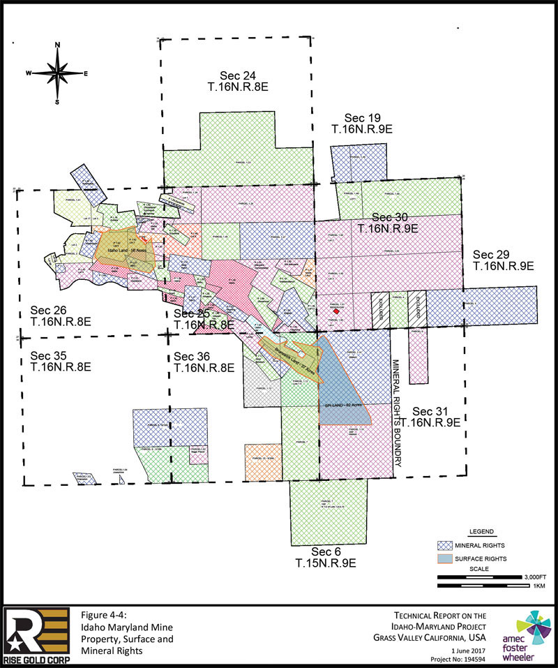
| Figure 4-4: | Idaho-Maryland Mine Property, Surface and Mineral Rights | 4-10 |
| Figure 4-5: | Mill Site Property, Adjacent the Brunswick Shaft | 4-17 |
| Figure 5-1: | Grass Valley Precipitation Data for Period 1981 to 2010 (NOAA, 2017) | 5-3 |
| Figure 5-2: | Grass Valley Temperature Data for Period 1981 to 2010 (NOAA, 2017) | 5-3 |
| Figure 5-3: | Brunswick Vertical Shaft, Cross-Section (Idaho Maryland Mines Corp) | 5-7 |
| Figure 5-4: | Main Access Roads showing Average Daily Trips to Brunswick Site (DOT, 2015) | 5-9 |
| Figure 6-1: | Gold Production (to nearest 1,000oz) of 25 Principal Gold-Mining Districts of the United States – through 1959 (Koschmann & Bergendahl, 1968) | 6-2 |
| Figure 6-2: | I-M Mine Gold Production from 1926-1955* | 6-18 |
| Figure 6-3: | Idaho-Maryland Mine Workings, Plan View | 6-19 |
| Figure 7-1: | Geologic Map of Northern California (from Taylor et al., 2015) | 7-2 |
| Figure 7-2: | General Geologic Map of the Grass Valley Gold District (from Taylor et al., 2015) | 7-4 |
| Figure 7-3: | Geology of the Idaho-Maryland Area | 7-6 |
| Figure 7-4: | General Faults and Veins of the Idaho-Maryland Area | 7-9 |
| Figure 7-5: | Idaho-Maryland Mine Long Section | 7-12 |
| Figure 7-6: | #1 Vein Cross Section, Section looking East (Lindgren, 1896) | 7-13 |
| Figure 7-7: | #1 Vein Cross Section, Section A | 7-14 |
| Figure 7-8: | #2 And #3 Veins Plan View | 7-16 |
| Figure 7-9: | 3 Vein System Cross Section, Section B | 7-17 |
| Figure 7-10: | Brunswick Vein System Cross Section, Section C | 7-19 |
| Figure 7-11: | Brunswick Vein System Plan View, 1600 Level | 7-20 |
| Figure 7-12: | Morehouse 52 Vein and 60 Winze Plan View | 7-22 |
| Figure 7-13: | Morehouse Geological Cross Section, Section D | 7-23 |
| Figure 8-1: | Schematic Representation of Crustal Environments of Hydrothermal Gold Deposits (modified from Groves et al., 1998) | 8-1 |
| Figure 8-2: | Relationship between Epithermal Veins, Gold-rich Porphyry, Skarn, and Orogenic Gold Deposits (Groves et al., 1998) | 8-5 |
| Figure 9-1: | Exploration Target Zones – Historic Drill Holes & Channel Sample Locations, Reference Figure | 9-2 |
| Figure 9-2: | #1 Vein Target I2400 Level West Channel Sample Locations | 9-4 |
| Figure 9-3: | #1 Vein Target I2400 Level Drilling | 9-9 |
| Figure 9-4: | Idaho #1 Vein Exploration Target Long Section | 9-10 |
| Figure 9-5: | #1 Vein Exploration Target Plan View | 9-11 |
| Figure 9-6: | #1 Vein Target Isometric View | 9-12 |
| Figure 9-7: | Crackle Zone Target 52 Vein/60 Winze Workings | 9-14 |
| Figure 9-8: | Crackle Zone Target 60 Winze Channel Sample Locations | 9-16 |
| Figure 9-9: | Crackle Zone Target Isometric View | 9-21 |
| Figure 9-10: | Crackle Zone Target Isometric View and 60 Winze Drilling | 9-22 |
| Figure 9-11: | Rose Garden Target Plan View | 9-26 |
| Figure 9-12: | Rose Garden 23 Winze & #1 Raise Channel Sample Locations | 9-27 |
| Project No.: 194594 | Page vi | |
| | Technical Report on the Idaho-Maryland Project Grass Valley California, USA |
| Figure 10-1: | Idaho-Maryland Project Drill Plan View | 10-6 |
| Figure 12-1: | Concrete Rock Silo Adjacent the Brunswick Shaft; View Looking West | 12-2 |
| Figure 12-2: | Mill Site Property, View Looking Southeast | 12-3 |
| Figure 12-3: | Mill Site Property, View Looking Northeast | 12-3 |
| Figure 24-1: | Diffracted Laser Point on Quartz Rock | 24-3 |
| Figure 24-2: | Laser Point on Non-quartz Rock | 24-4 |
| Figure 26-1: | Plan View of Proposed Drill Hole and Generalized Geology at I2700 Level | 26-3 |
| Figure 26-2: | Section View of Proposed Drill hole and Generalized Geology | 26-4 |
| Project No.: 194594 | Page vii | |
| | Technical Report on the Idaho-Maryland Project Grass Valley California, USA |
| 1.0 | SUMMARY |
| 1.1 | Introduction |
At the request of Rise Gold Corp (“Rise” or the “Company”), Amec Foster Wheeler (“Amec”) was retained to prepare an independent Technical Report (the “Report”) on the Idaho-Maryland Mine (I-M Mine) Property near Grass Valley, California (USA). This Report has been prepared in accordance with Canadian Securities Administrator’s National Instrument 43-101 Standards of Disclosure for Mineral Projects (“NI 43-101”) and its related Form 43-101F1. The effective date of this Report is 1 June, 2017.
Mr. Greg Kulla, P.Geo, of Amec Foster Wheeler served as the Independent Qualified Person responsible for preparation of the Report. Mr. Kulla visited the Idaho-Maryland Mine Property on the 29th of March 2017 and met with Rise’s attorney, Mr. Braiden Chadwick, in Roseville, California to discuss mineral tenure, surface rights, and permitting with respect to the I-M Mine Property.
| 1.2 | Key Findings |
The Idaho-Maryland Mine was a prolific gold producer in the Grass Valley – Nevada City District in Nevada County of California. It is an orogenic gold deposit, a deposit type known to have consistent high gold grades in quartz veins over significant vertical extents. The neighboring Empire Mine, operated by Newmont until 1957, was mined to a vertical depth of approximately 3,500ft (~1 km). Veins in the Mother Lode have been followed to a vertical depth of 5,700ft (~1.7 km). Mining of the gold-rich Idaho #1 Vein and 3 Vein System terminated at a vertical depth of approximate 2,000ft (~0.6 km). Exploration drifting on the I2400 Level has demonstrated the mineralized system of the Idaho #1 Vein continues with depth. Exploration drifts and subsequent mining in local areas demonstrate gold mineralization is still present at the I2700 Level in other areas of the mine.
Rise has carefully compiled a significant archive of historical level plans and other documents, prepared a 3D model of key geologic attributes, underground workings, and drill hole traces. Rise used this model and the archived reports to identify several significant unexplored exploration targets below the current workings within the Idaho-Maryland Mine Property which include:
| Project No.: 194594 | Page 1-1 | |
| | Technical Report on the Idaho-Maryland Project Grass Valley California, USA |
#1 Vein Target
| ● | This is a possible down-plunge extension of the prolific Eureka-Idaho stope. The #1 Vein target covers an area 2,150ft (655m) between the I2400 Level west and east drifts and 500ft to 1,000ft (152m to 305m) down-dip from the I2400 level. Within this area gold mineralization may occur within a quartz vein adjacent to the diabase dike similar to that encountered in the prolific Eureka-Idaho stope above or may be hosted within the adjacent diabase dike. The projected down-dip extension of the #1 Vein target is defined in relation to the deepest mineralization encountered at the nearby Empire Mine. This does not preclude deeper mineralization. |
Crackle Zone Target
| ● | This is a wedge-shaped area 2,000ft (610m) wide and 500ft to 1,00 0ft (152m to 305m) thick at the I2700 Level, plunging as much as 5,000ft (1,524m) to the south east where it pinches out against the intersection of the Idaho, Morehouse, and 6-3 Faults. Within this zone gold mineralization may occur in shallow dipping quartz veins and irregular quartz stockworks in metavolcanic rocks that may be highly fractured due to the interaction of the Idaho, Morehouse, and 6-3 Faults. |
Brunswick Target
| ● | The Brunswick area offers many areas with potential for discovery of mineralization, particularly the area below the existing stoping and in the untested area in the immediate footwall of the 6-3 Fault south east of the Brunswick shaft. In Brunswick Mine, the richest mineralization was typically found near the 6-3 Fault. Below 1600 Level, development in the southern region of the Brunswick Mine deviated to the west, away from the 6-3 Fault leaving a region of unexplored ground in the footwall adjacent to the fault approximately 500ft to 1,000ft (152m to 305m) thick, 1,000ft to 2,000ft (305m to 610m) wide, and 1,00 0ft to 3,000 ft (305m to 914m) deep. |
3 Vein – Rose Garden Target
| ● | Rose Garden-style mineralization is hosted solely in serpentinite with no apparent association with the brittle rocks common in all other mine and target areas of the Idaho-Maryland project. Serpentinite within the Idaho fault zone, east towards the 6-3 Fault and west of the 3 Vein area may host mineralization similar to the Rose Garden. |
All exploration targets are below current extents of drilling and development and warrant exploration through drilling. Through its life, the Idaho Maryland Mine faced several shut downs related to fires and war measures that resulted in loss of access to some promising areas due
| Project No.: 194594 | Page 1-2 | |
| | Technical Report on the Idaho-Maryland Project Grass Valley California, USA |
to collapsed workings or early termination of planned developments. Exploration potential may remain in the some of these areas.
| 1.3 | Property Description and Ownership |
The Idaho-Maryland Mine Property located in Nevada County near Grass Valley, California (USA) comprises approximately 93 acres surface land and approximately 2,800 acres mineral rights. The fee simple land package is separated into two parts, (1) Idaho land representing 56 acres and (2) Brunswick land representing 37 acres. In addition, Rise has an option to purchase an additional 82 acres of surface land, termed the Mill Site Property, directly adjacent to the Brunswick land.
The recorded owner of the surface land and mineral rights associated with the Property is Rise Grass Valley Inc., a Nevada Corporation and subsidiary of Rise Gold Corp, as documented by a Quitclaim Deed recorded by the County Recorder in Nevada County on 26th of January 2017.
The Company owns a 100% interest in the Idaho-Maryland Mine Property and there are no royalties on future gold production. There are no other agreements or encumbrances to which the Property is subject.
Rise is planning a preliminary exploration diamond drilling program from surface with planned drill collars located on its Brunswick land, positioned within Nevada County’s “M1” Light Industrial Zone. Exploration diamond drilling on M1 – Industrial Land is an allowed use and does not require a discretionary permit provided that no water is discharged offsite and disturbance per site is less than 1 acre and 1,000yd3 material.
The Company plans to use multiple forms of sound barriers to reduce noise levels associated with diamond drilling below Nevada County standards. In addition, a closed-circuit water system consisting of a mobile Solids Removal Unit will be utilized.
| 1.4 | History |
The Idaho-Maryland Mine, located in the Grass Valley – Nevada City mining district of northern California was one of the most productive and best known gold mines in the United States. The Idaho-Maryland Mine has a rich history of gold production and mining work completed between 1863 and 1956 by various operators.
| Project No.: 194594 | Page 1-3 | |
| | Technical Report on the Idaho-Maryland Project Grass Valley California, USA |
The Idaho-Maryland Mine represents a consolidation of several important early day producing mines including Eureka, Idaho, Maryland, Brunswick, and Union Hill Mines. Based on historic production records, these mines produced a total of 2.4M oz gold at an average mill head grade of approximately 0.5oz/ton (17.1 grams per metric tonne (“gpt”)).
The I-M Mine was reportedly the second largest gold mine in the United States in 1941, producing up to 129,000 oz gold per year before being forced to shut down by the US government in 1942 due to World War II. Significant production after the war-time shutdown never occurred.
The Property was rediscovered in 1990 and efforts were made to reopen the historic mine; however, the operator was unsuccessful due to inability to raise necessary funding in unfavourable market conditions.
| 1.5 | Geology and Mineralization |
The Idaho-Maryland Project is located in the Grass Valley area of the Western Sierra Nevada Foothills of Northern California. This belt of rocks consists of late Paleozoic marine sedimentary and ophiolitic rocks, and early and late Mesozoic submarine volcanic-arc and basinal terranes.
The Jura-Triassic arc belt has yielded the majority of gold production in the Western Sierra Nevada Foothills. Gold deposits in Jura-Triassic arc belt are associated with second, third, and fourth–order faults related to the regionally significant Wolf Creek/Bear Mountain and Melones faults.
The Grass Valley area is dominated by blocks of variably metamorphosed volcanic, mafic plutonic, and minor sedimentary rocks hosted in a serpentinite matrix. The whole package of rocks exhibits a region foliation and is interpreted as a serpentinite-matrix tectonic mélange. These rocks were variably metamorphosed from lower greenschist to amphibolite facies during and after accretion to the continental margin. Two distinct gold vein groups exist within the Grass Valley district: steeply dipping E-W-trending veins in the northern and generally N-S trending veins with gentler dips averaging 35° in the southern part of the district. The most important E-W veins are associated with the Idaho-Maryland project. Both vein sets have extraordinary vertical and lateral persistence; individual veins extend for kilometers.
All of the significant gold production from the Idaho-Maryland Mine was localized within and around the Brunswick Block, which consists of variably metamorphosed volcanic and intrusive, and minor sedimentary rocks. The Brunswick Block is surrounded to the west, north, and east by gabbro and serpentinite rocks. Overlying Tertiary volcanic rocks mask rock units along the
| Project No.: 194594 | Page 1-4 | |
| | Technical Report on the Idaho-Maryland Project Grass Valley California, USA |
southern boundary of the Brunswick Block. The contacts between the Brunswick Block and surrounding gabbro and serpentinite are dominated by the 6-3, the Idaho, and the Morehouse fault domains. Mineralization is closely associated with these significant second or third order structures close to the contact between the Brunswick block and serpentinite contact. Gold in the quartz veins occurs as native gold, ranging from very fine grains to large nuggets within the quartz. Sulfide minerals, primarily pyrite with lesser galena, chalcopyrite, from 1% to 4% are commonly associated with gold mineralization. Scheelite is common in the Union Hill area near the Brunswick mine. Gangue minerals include quartz, carbonate, sericite, chlorite, mariposite, and albite. Ankerite is a common alteration mineral and may occur in the mafic and ultra-mafic rocks and the meta-volcanic rocks. The mineralized wallrock is strongly carbonate altered.
Gold mineralization at the Idaho-Maryland deposit can be divided into three significant vein systems; the Idaho, the Brunswick, and the Morehouse systems.
| 1.6 | Exploration |
Rise has not completed any exploration survey or sampling programs on the Property of the I-M Mine but has completed a substantial desktop exploration study through compiling the extensive collection of historical data that has been preserved since the I-M Mine shut-down in 1956. The comprehensive data compilation work allowed Rise to develop an accurate digital diamond drill hole database, 3D mine model, and 3D geological model and to summarize production records.
Rise identified four unexplored exploration targets which are discussed in Section 9 of this Report.
| 1.7 | Mineral Resource Estimate |
The present Report does not include a mineral resource estimate. Rise is not treating the historical mineral resource estimate as a current mineral resource estimate.
| 1.8 | Other Relevant Data |
Rise is focused on mineral exploration at the Idaho-Maryland Mine and is not contemplating the permitting or re-opening of the I-M Mine at this time.
| Project No.: 194594 | Page 1-5 | |
| | Technical Report on the Idaho-Maryland Project Grass Valley California, USA |
The Project area is covered by private land and no permits or consultations with the US Bureau of Land Management (BLM) or the US Forest Service (USFS) would be required.
| 1.9 | Interpretation and Conclusions |
The Idaho-Maryland project has several good exploration targets. Each of these targets is substantial in size and warrant exploration drilling. Diamond drilling from surface is recommended as the mine is currently flooded. Acquiring a permit to dewater the mine is possible but the time required to apply and grant the permit and the time to dewater and repair workings would be considerable.
| 1.10 | Recommendations |
The I-M Project hosts numerous exploration targets that warrant drilling. While a significant drill program is required to test these targets, Rise requested Amec Foster Wheeler prepare a recommended drill program not to exceed $600k.
An exploration program consisting of a single 6,000ft (1,830m) diamond drill hole to test the concept of two of the exploration targets is proposed. The cost of this drill program is expected to be $595,000. The exploration recommendations are detailed in Section 26 of this Report.
| Project No.: 194594 | Page 1-6 | |
| | Technical Report on the Idaho-Maryland Project Grass Valley California, USA |
| 2.0 | INTRODUCTION |
| 2.1 | Terms of Reference |
Amec Foster Wheeler was retained by Rise Gold Corp (“Rise” or the “Company”) to prepare a Technical Report (the “Report”). This Report has been prepared in accordance with Canadian Securities Administrator’s National Instrument 43-101 Standards of Disclosure for Mineral Projects (“NI 43-101”) and its related Form 43-101F1.
Rise Gold Corp is an exploration stage mining company trading publicly on the Canadian Securities Exchange (CSE: RISE) and on the US OTC Markets (OTC: RYES). Rise was incorporated in Nevada, USA in 2007 and maintains its head office in Vancouver, British Columbia, Canada. On April 7th, 2017, the Company changed its name from Rise Resources Inc. to Rise Gold Corp.
The Company’s principal asset is the historic past-producing Idaho-Maryland Gold Mine located in California, USA. Rise is 100% owner of the Idaho-Maryland Mine Property through its subsidiary Rise Grass Valley, Inc.
The purpose of this Report is to present the history, consolidate all historical documents and information, present the geology and geological model, discuss exploration targets, and to provide recommendations for exploration of the Idaho-Maryland Mine Property.
Rise Gold Corp has a significant interest in the qualifying property, the Idaho-Maryland Mine Property.
| 2.2 | Principal Sources of Information |
The acquisition of the Idaho-Maryland Mine Property included a significant collection of historic records of the Idaho-Maryland Mine such as reports, production records and data, financial statements, development reports, survey data, exploration drill results, maps showing mine workings, geological information, and assay results. The historic records have been compiled by Rise Gold Corp, reviewed by Amec Foster Wheeler, and are used to support this Report.
Section 27 provides references used to support this Report.
| Project No.: 194594 | Page 2-1 | |
| | Technical Report on the Idaho-Maryland Project Grass Valley California, USA |
| 2.3 | Site Visits |
Mr. Greg Kulla visited the Idaho-Maryland Mine Property near Grass Valley, California on the 29th of March 2017. During the site visit Mr. Kulla inspected Rise’s surface land holdings and the Mill Site Property, to which Rise holds an option to purchase. Mr. Kulla inspected potential dill sites for the drill program proposed herein and observed the decommissioned and locked New Brunswick Mine shaft and the Union Hill Mine shaft on the Brunswick lands. In addition, Mr. Kulla visited the historical “Round Hole Shaft”, a ventilation shaft to support the Idaho-Maryland Mine. The Round Hole Shaft is not within Rise’s current land holdings.
On the 30th of March 2017, Mr. Kulla met with Mr. Braiden Chadwick at Mitchell Chadwick’s office in Roseville California to discuss mineral tenure, surface rights, and permitting with respect to the Idaho-Maryland Mine Property.
| 2.4 | Effective Date |
The effective date of this Report is 1 June, 2017.
| 2.5 | Units, Currencies, and Abbreviations |
All units in this Report are based on the U.S. Customary System (USCS), or more commonly referred to as imperial units. For reference purposes, metric units of the International System of Units (SI units) will also be provided. All currency amounts are stated in Canadian Dollars ($, CA$, CAD) or US dollars (US$, USD).
This Report uses many abbreviations and acronyms common in the mining industry, most of which are defined in the body of the text. A list of abbreviations that may appear in this Report is provided in Table 2-1.
| Project No.: 194594 | Page 2-2 | |
| | Technical Report on the Idaho-Maryland Project Grass Valley California, USA |
| Table 2-1: List of Abbreviations | ||||||
| above mean sea level | AMSL | maximum intermittent noise | Lmax | |||
| acre-feet | ac-ft | miles | mi | |||
| acres | ac | million | M | |||
| Assessor’s parcel number | APN | million years | Ma | |||
| average daily trips | ADT | Mount Diablo Base and Meridian | MDM | |||
| average-hourly noise | Leq | ounce (Troy ounce) | oz | |||
| A-weighted decibel | dBA | ounce per ton | oz/ton | |||
| Bouma, Erickson, & Toms | BET | Portion | Ptn | |||
| Canadian | CDN | pounds | lbs | |||
| Canadian Dollar | $ | qualified person | QP | |||
| cubic feet per minute | cfm | Quitclaim | QC | |||
| decibel | dB | Range | Rng | |||
| degrees Fahrenheit | °F | Rise Gold Corp | Rise | |||
| dollar per ton | $/ton | Section | Sec | |||
| feet | ft | thousand | k | |||
| gallons per minute | GPM | ton (2000 lbs) | t / ton | |||
| gold | Au | ton per day | tpd | |||
| tonne (2204.6lbs or 1000kg) | T | |||||
| grams | g | Township | Twn | |||
| grams per tonne | gpt | Trace | Tr | |||
| hectares | ha | United States | US | |||
| inches | in | Universal Transverse Mercator | UTM | |||
| kilometres | km | US National Grid | USNG | |||
| kilovolt | kV | yard | yd | |||
| Level | L | |||||
| 2.6 | Idaho-Maryland Mine Property – Use of Terms |
This Technical Report requires familiarity of the naming used for the Property. Table 2-2 summarizes the use of terms specific to the Idaho-Maryland Mine Property.
| Project No.: 194594 | Page 2-3 | |
| | Technical Report on the Idaho-Maryland Project Grass Valley California, USA |
Table 2-2: Idaho-Maryland Mine Property - Use of Terms
Idaho-Maryland Mine Property
|
Alternatively, “Idaho-Maryland Mine”, “I-M Mine”, “Idaho-Maryland”, “Idaho-Maryland Mine Project”, “Property” or “Project”.
Refers to all that encompasses the Idaho-Maryland Mine Property, including Idaho Mine, Brunswick Mine, and the land associated with the Mines.
Note: Historically, until approximately 1926, Idaho-Maryland Mine referred to the consolidation of “Idaho Mine” and “Maryland Mine”. After approximately 1925, Idaho-Maryland Mine referred to the entire consolidation of mines, inclusive of Brunswick Mine. |
| Brunswick Mine | Includes the original “Old Brunswick Mine”, “New Brunswick Mine”, “Union Hill Mine” and the associated veins. |
| Old Brunswick | Original development of “Brunswick Mine”, accessed by an inclined shaft “Old Brunswick Shaft”.
Old Brunswick area developed to 1200-foot Level (1200L). |
| New Brunswick | Forms the larger part of “Brunswick Mine”, accessed by a vertical shaft “New Brunswick Shaft”. New Brunswick area developed to 3280L.
Note: A connection with “Idaho Mine” is established on 1300L, 2300L, and 3280L. |
| Union Hill | Includes areas such as “Union Hill”, “Gold Point”, “Lucky”, “Cambridge”, “Greek Tungsten”, and “Georgia” and the associated veins.
Forms part of the “Brunswick Mine”. “Union Hill Mine” area is developed to 1200L.
Note: All mining at the “Union Hill Mine” was completed prior to 1919. |
| Idaho Mine | Includes the original “Idaho Mine”, “Eureka Mine”, “Maryland Mine” and the associated veins.
Note: A connection with “Brunswick Mine” is established on Idaho 1000L (Brunswick 1300L), Idaho 2000L (Brunswick 2300L) and Idaho 3000L (Brunswick 3280L). |
| #1 Vein | Originally named “Eureka Vein”, subsequently “Eureka-Idaho-Maryland Vein”.
#1 Vein outcrop is the original gold discovery of what is later developed into the Idaho-Maryland Mine Property.
#1 Vein is part of the larger “Idaho Mine”. |
| #2 Vein | Alternatively, “Dorsey Vein”.
#2 Vein is part of the larger “Idaho Mine”. |
| 3 Vein System | Consists of “#3 Vein” and its splays. Many veins make up the 3 Vein System, with the largest being the #3 Vein.
3 Vein System is part of the larger “Idaho Mine”. |
| Round Hole Shaft | Alternatively, “No. 2 Shaft”.
5ft (1.5m) diameter round bore hole was advanced to 1200L and used for access and ventilation. Located in “Idaho Mine”. |
| Project No.: 194594 | Page 2-4 | |
| | Technical Report on the Idaho-Maryland Project Grass Valley California, USA |
| 3.0 | RELIANCE ON OTHER EXPERTS |
The author of this Report has relied upon and disclaims responsibility for information provided by Rise Gold Corp’s legal experts pertaining to mineral rights, surface rights, royalties and agreements, environment, and permitting related to the Idaho-Maryland Mine Property.
| 3.1 | Mineral Rights |
Amec Foster Wheeler has fully relied upon and disclaims responsibility for information regarding mineral rights provided by experts through the following document:
| ● | Letter from Mitchell Chadwick dated 31 May 2017 regarding the status of mineral tenure. |
Amec Foster Wheeler has not reviewed the mineral rights ownership nor independently verified the legal status of the mineral rights of the I-M Mine Property.
Information from this letter has been used in Section 4 of this Report.
| 3.2 | Surface Rights |
Amec Foster Wheeler has fully relied upon and disclaims responsibility for information regarding surface rights provided by experts through the following document:
| ● | Letter from Mitchell Chadwick dated 31 May 2017 regarding the status of surface rights. |
Amec Foster Wheeler has not reviewed the surface rights ownership nor independently verified the legal status of surface rights of the I-M Mine Property.
Information from this letter has been used in Section 4 of this Report.
| 3.3 | Royalties and Agreements |
Amec Foster Wheeler has fully relied upon and disclaims responsibility for information regarding royalties and agreements provided by experts through the following document:
| Project No.: 194594 | Page 3-1 | |
| | Technical Report on the Idaho-Maryland Project Grass Valley California, USA |
| ● | Letter from Mitchell Chadwick dated 31 May 2017 regarding the status of royalties and agreements. |
Amec Foster Wheeler has not reviewed the royalties and agreements for the Property nor independently verified the legal status of any royalties and agreements related to the I-M Mine Property.
Information from this letter has been used in Section 4 of this Report.
| 3.4 | Environmental, Permitting, and Liability Issues |
Amec Foster Wheeler has fully relied upon and disclaims responsibility for information regarding environment, permitting, and liability issues provided by experts through the following document:
| ● | Letter from Mitchel and Chadwick dated 31 May 2017 regarding the status of environmental, permitting, and liability Issues. |
Information from this letter has been used in Section 4 of this Report.
| 3.5 | Mitchell Chadwick Expertise |
Mitchell Chadwick attorneys have permitted more than 200 mines in California. They have experience permitting on private land, California State Lands Commission land, and federal lands including Bureau of Land Management, Forest Service, Bureau of Indian Affairs and National Park Service lands.
The attorneys at Mitchell Chadwick represent regional, national and multinational mining companies regarding all phases of mining operations, including due diligence and acquisition of mining sites/mineral rights, permitting and environmental review, litigation, permit compliance issues, and final reclamation.
Mitchell Chadwick attorneys have extensive experience obtaining all local, state, and federal mining entitlements, including conditional use permits, reclamation plans under the Surface Mining and Reclamation Act (SMARA), and Bureau of Land Management and Forest Service plans of operation and rights-of-way. Landowners and mining companies seek the expertise of
| Project No.: 194594 | Page 3-2 | |
| | Technical Report on the Idaho-Maryland Project Grass Valley California, USA |
Mitchell Chadwick in obtaining state and federal endangered species act permits (Section 7, 10a and 2081), wetlands/stream alteration permits under the federal Clean Water Act and Cal. Fish & Game Code (Sections 404 and 1603), water quality permits (waste discharge, NPDES, and 401 certifications), and air quality permits.
Mitchell Chadwick attorneys are state-recognized experts in public lands law and assist the mining industry involving title to unpatented and patented mining claims, including preparation of title opinions, right-of-way and wilderness area access, BLM and Forest service contest actions, annual BLM rental fee filings, state lands, Indian lands, and appeals to the Interior Board of Land Appeals (IBLA).
Additionally, the Mitchell Chadwick firm represents mining companies in connection with the negotiation and drafting of purchase and sale agreements, mining leases, contracts, and joint venture agreements, royalty agreements, easements, the acquisition of mineral rights and mining claims, and the negotiation and due diligence for project acquisitions for sellers, buyers, and lenders. Mitchell Chadwick assists mining clients with the acquisition, perfection, and transfer of water rights, and in water quality proceedings, including permitting, compliance, and litigation.
G. Braiden Chadwick is a Partner of Mitchell Chadwick LLP. His representation regularly includes appearances before local, regional, state and federal administrative agencies in connection with use permits and other entitlements. He handles all aspects of environmental compliance under the California Environmental Quality Act (CEQA) and the National Environmental Policy Act (NEPA), land-use permitting and any resulting litigation. His permitting work extends from California’s largest ski resorts, to residential developers, oil gas and energy companies, wineries, agricultural entities, landfills, mitigation/conservation banks, and mining companies.
| Project No.: 194594 | Page 3-3 | |
| | Technical Report on the Idaho-Maryland Project Grass Valley California, USA |
| 4.0 | PROPERTY DESCRIPTION AND LOCATION |
| 4.1 | Property Location |
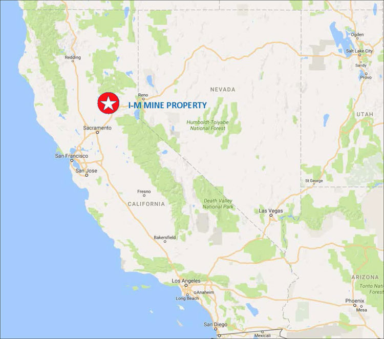
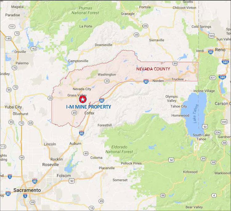
The Idaho-Maryland Mine Property (the Property) comprises approximately 93 acres (38 hectares) surface land and approximately 2,800 acres (1,133 hectares) mineral rights located near Grass Valley of Nevada County in northern California, USA. Rise has an option to purchase an additional 82 acres of surface land in the Project area. The Property is situated in the Grass Valley-Nevada City District along the western slope of the Sierra Nevada, as shown on the overview map and regional map in Figure 4-1 and Figure 4-2, respectively. The Property is located approximately 60 miles northeast of Sacramento, CA and 90 miles west of Reno, NV. The Property, on US National Grid Zone 10S, Square FJ is centred on 39°12’40“N, 121°1’5“W. Additionally, the UTM coordinates are 671,114E, 4,342,078N of NAD83 (Zone 10S).
| Project No.: 194594 | Page 4-1 | |
| | Technical Report on the Idaho-Maryland Project Grass Valley California, USA |
Figure 4-1: Idaho-Maryland Mine Property Location Overview
| Project No.: 194594 | Page 4-2 | |
| | Technical Report on the Idaho-Maryland Project Grass Valley California, USA |
Figure 4-2: Idaho-Maryland Mine Property, Regional Map
| Project No.: 194594 | Page 4-3 | |
| | Technical Report on the Idaho-Maryland Project Grass Valley California, USA |
| 4.2 | Property Description |
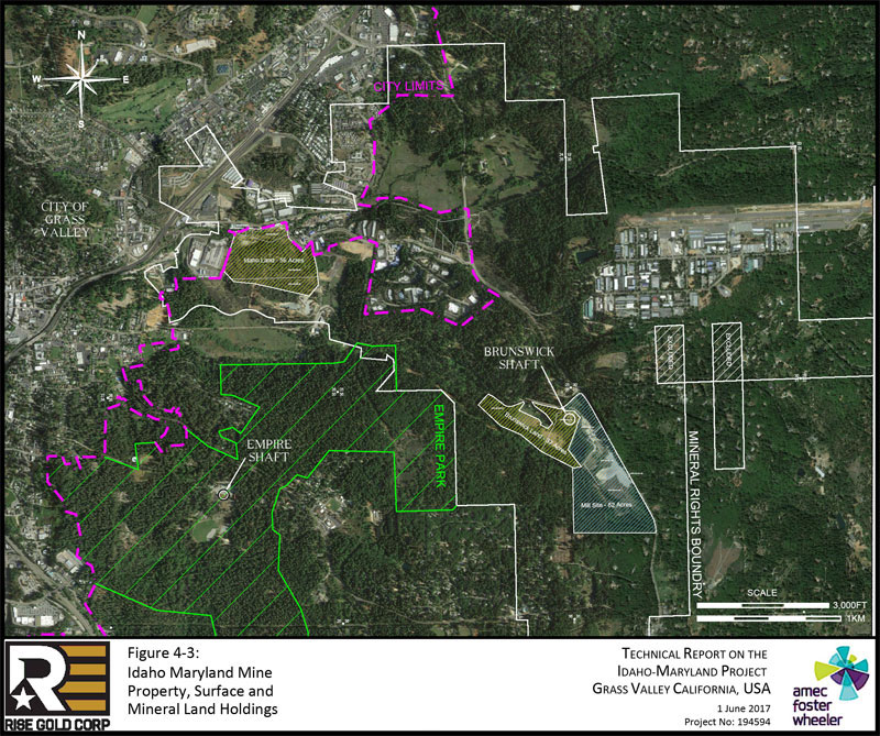
The recorded owner of the surface land and mineral rights associated with the Property, as documented by a Quitclaim Deed recorded by the Nevada County Recorder on the 26th of January 2017 (Document #: 20170001985), is Rise Grass Valley Inc., a Nevada Corporation and subsidiary of Rise Gold Corp. Rise Grass Valley Inc. purchased the Property, inclusive of its mineral rights from the Grantors of the BET Group Estate, as described in the Quitclaim Deed (Document #: 20170001985), on the 25th of January 2017. The original BET Group is comprised of three parties (1) Mary Bouma, (2) Erika Erickson, and (3) William Toms, each representing an undivided 1/3 interest.
| 4.2.1 | Surface Rights |
The Property surface rights include two parts of fee simple land, (1) Idaho land representing 56 acres (23 hectares) and (2) Brunswick land representing 37 acres (15 hectares) as displayed in Figure 4-3.
The Property consists of parcels of surface land located in portions of Section 26 and 36, Township 16 North – Range 8 East Mount Diablo Base and Meridian (MDM) and Section 31, Township 16 North – Range 9 East MDM as detailed in Table 4-1 and displayed in Figure 4-3.
Table 4-1: Idaho-Maryland Mine Property – Surface Land Legal Description
| Parcel Number |
Description | Lot Size |
| 09-550-32 | SEC 26, TWN 16N, RNG 8E, MDM, PTN N 1/2 26-16-8 | 20,908
SF (0.48 AC) |
| 09-550-37 | SEC 26, TWN 16N, RNG 8E, MDM, PTN NE 1/4 26-16-8 | 4.47 AC |
| 09-550-38 | SEC 26, TWN 16N, RNG 8E, MDM, PTN NE 1/4 26-16-8 | 40.1 AC |
| 09-550-39 | SEC
26, TWN 16N, RNG 8E, MDM, PTN NE 1/4 26-16-8 344 CENTENNIAL DRIVE GRASS VALLEY, CA 95945 |
42,668
SF (0.98 AC) |
| 09-550-40 | SEC 26, TWN 16N, RNG 8E, MDM, PTN NE 1/4 26-16-8 | 5,662
SF (0.13 AC) |
| 09-560-36 | SEC 26, TWN 16N, RNG 8E, MDM, PTN N 1/2 SE 1/4 26-16-8 | 10.25 AC |
| 09-630-37 | SEC 36, TWN 16N, RNG 8E, MDM, LOT 6 BET ACRES | 21.8 AC |
| 09-630-39 | SEC
36, TWN 16N, RNG 8E, MDM & SEC 31, TWN 16N, RNG 9E, MDM, LOT 7 BET ACRES |
15.07 AC |
| Project No.: 194594 | Page 4-4 | |
| | |
| Page 4-5 |
| | Technical Report on the Idaho-Maryland Project Grass Valley California, USA |
| 4.2.1.1 | Surface Land Obligations |
Fee simple ownership in California is the strongest and most complete form of ownership as no other parties have any ability to limit the rights of the owner. Fee simple ownership entitles the owner to all rights of the property, which are only restricted by law or private restrictions, such as zone ordinances or covenants. Fee simple owners retain possession of their property permanently, assuming all obligations to the land are met.
The surface land is subject to a tax lien imposed by and payable to Nevada County. Property tax is paid on a biannual basis, the first installment due November 1st and the second installment due February 1st of each fiscal year. Taxes unpaid by the end of the fiscal year (June 30th) are required to pay delinquent penalties. Properties delinquent for the first year shall be declared defaulted for non-payment of taxes. After five years, the Tax Collector has the power to sell tax-defaulted property, which has not been redeemed.
The parcels comprising the Idaho land and Brunswick land have a combined annual property tax of $16,126.78 for the fiscal year ending June 30th, 2017, as detailed in Table 4-2. The total amount includes County taxes and Agency taxes. The Property remains in good standing with property taxes paid in full through June 30th, 2017.
Table 4-2: Property Tax, for Fiscal Year July 1, 2016 to June 30, 2017
| Parcel No. | Installment 1 (USD) | Installment 2 (USD) | ||
| 09-550-32-000 | $72.66 | $72.66 | ||
| 09-550-37-000 | $407.38 | $407.38 | ||
| 09-550-38-000 | $3,441.03 | $3,441.03 | ||
| 09-550-39-000 | $97.91 | $97.91 | ||
| 09-550-40-000 | NO TAXES | NO TAXES | ||
| 09-560-36-000 | $847.04 | $847.04 | ||
| 09-630-37-000 | $1,897.36 | $1,897.36 | ||
| 09-630-39-000 | $1,300.01 | $1,300.01 | ||
| Total Property Tax | $8,063.39 | $8,063.39 | ||
The Nevada Irrigation District supplies treated water to the Property. Water to the Brunswick land is delivered from the Loma Rica System, while water to the Idaho land is delivered from the E. George System. A nominal service fee is charged.
| Project No.: 194594 | Page 4-6 | |
| | Technical Report on the Idaho-Maryland Project Grass Valley California, USA |
There are no further interests registered against the title of the surface rights.
Details of previous environmental studies on the Property are discussed in Section 24 of this Report.
| 4.2.1.2 | Land Designation |
The Brunswick land is located approximately 1 to 2 miles southeast of the city limits of the City of Grass Valley in Nevada County. The Idaho land is located on Idaho-Maryland Rd adjacent to the city limits of the City of Grass Valley in Nevada County. The Property in relation to city limits is shown on Figure 4-3. Due to its proximity, the Property is located within the City of Grass Valley’s planning area boundary, with Brunswick land located in the “Long-term Annexation” and Idaho land located in the “Near-term Annexation” Sphere of Influence.
All California cities have a sphere of influence, typically encompassing an area broader than the city limits. Sphere of Influence is the planned area for the probable physical boundaries and service area of a local government agency, as determined by the Local Agency Formation Commission (LAFCo). The City of Grass Valley Sphere of Influence Plan defines the planning horizons as near-term (five years) and long-term (twenty years) (Kleinschmidt, 2011). Based on the City of Grass Valley 2020 General Plan, the planned land use designation for the Brunswick land remains “M-1” Manufacturing/Industrial, while the planned land use designation for the Idaho land is “BP” Business Park (CoGV-CDD, 2009). The impact of potential annexation is described in Section 4.7.2.1 of this Report.
Each of the parcels of Brunswick land and Idaho land are currently positioned within the County’s “M1” Light Industrial Zone. Within the “M1” District, surface access to subsurface mining (e.g., vent and escape shafts) is allowed with a Use Permit (Nevada County Code § L-II 3.21.). Mineral exploration, however, is distinct from the definitions of “subsurface mining” and “surface mining.” Exploration involves the search for economic minerals through the use of geological surveys, geophysical or geochemical prospecting, bore holes and trial pits, and surface or underground headings, drifts, or tunnels (NCC § L-II 3.22(B)(5).). Permit requirements for mineral exploration are described in Section 4.5 of this report.
The Project area is private land and no permits or consultations with the US Bureau of Land Management (BLM) or the US Forest Service (USFS) are required.
| Project No.: 194594 | Page 4-7 | |
| | Technical Report on the Idaho-Maryland Project Grass Valley California, USA |
| 4.2.2 | Mineral Rights |
The Property consists of mineral rights on 10 parcels, including 55 subparcels, totaling 2,800 acres (1,133 hectares), of full or partial interest, as detailed in Table 4-3 and displayed in Figure 4-4. The mineral rights encompass the past producing Idaho-Maryland Mine which includes the Idaho and Brunswick underground gold mines.
The original mineral rights were granted at various times since 1851. Through various patents and agreements since the original grants, there has been a succession of ownership of the mineral rights.
The Quitclaim Deed describes the mineral rights as follows:
The Property consists of all rights to minerals within, on, and under the land shown upon the Subdivision Map of BET ACRES, No. 85-7, filed in the Office of the County Records, Nevada County, California, on February 24, 1987, in Book 7 of Subdivisions, at Page 75 et seq.
The Property consists of all rights to minerals within, on, and under the land located in portions of Sections 23, 24, 25, 26, 35, and 36 in Township 16 North – Range 8 East MDM, Sections 19, 29, 30, and 31 in Township 16 North – Range 9 East MDM, and Section 6 in Township 15 North – Range 9 East MDM and all other mineral rights associated with the Idaho-Maryland Mine.
The mineral rights are defined as parcels and subparcels in a Quitclaim Deed (Document #: 20170001985). All property is described in that Quitclaim Deed by Idaho Maryland Industries Inc. in favor of William Ghidotti and Marian Ghidotti, his wife as tenants in common, dated June 10, 1963. The Quitclaim deed is located at vol. 337, pp. 175-196 in the official records of Nevada County, as recorded on June 12, 1963.
The parcels (and subparcels) are listed and described in Table 4-3.
Mineral rights pertain to all minerals, gas, oil and mineral deposits of every kind and nature beneath the surface of all such real property, together with all necessary and convenient rights to explore for, develop, produce, extract and take the same, subject to the express limitation that the fore-going exception and reservation shall not include any right of entry upon the surface of said land without the consent of the owner of such surface of said land, as excepted in the Quitclaim Deed recorded the 26th of January 2017 (Document #: 20170001985). Mineral rights are severed from surface rights at a depth of 200ft (61m) below surface, with all mineral rights being contiguous below 200ft (61m) of surface.
| Project No.: 194594 | Page 4-8 | |
| | Technical Report on the Idaho-Maryland Project Grass Valley California, USA |
There are no interests registered against or obligations required of the mineral rights of the Property.
| Project No.: 194594 | Page 4-9 | |
| | |
| Page 4-10 |
| | Technical Report on the Idaho-Maryland Project Grass Valley California, USA |
Table 4-3: Quitclaim Deed Summary (Document #: 20170001985)
Parcel No. 1: Pertains to all minerals, gas, oil and mineral deposits of every kind and nature below a depth of 200ft (61m) from surface except where noted.
| Name | Location | Reference No. (QC = Quitclaim) | Interest | |||
| J.M. English Quartz Mine | Lot No. 54, SE1/4 Sec. 25, T 16 N, R 8 E, MDM | QC 1.1 (Parcel 1, subparcel 1) | 100% interest | |||
| Lucky or Agnes Quartz Mine | Lot No. 129, Sec. 25 & 36, T 16 N, R 8 E, MDM | QC 1.2 (Parcel 1, subparcel 2) | 100% interest | |||
| Union Hill Quartz Mine | Lot No. 59, Sec. 25 & 36, T 16 N, R 8 E, MDM | QC 1.3 (Parcel 1, subparcel 3) | 100% interest | |||
| Centennial Quartz Lode Mining Claim | Lot No. 106, Sec. 25, T 16 N, R 8 E, MDM | QC 1.4 (Parcel 1, subparcel 4) | 100% interest | |||
| Halphene Quartz Lode Mining Claim | Lot No. 202, Sec. 25, T 16 N, R 8 E, MDM | QC 1.5 (Parcel 1, subparcel 5) | 100% interest | |||
| “Dorothy D” Lode Mining Claim | Survey No. 5628, Sec. 25, T 16 N, R 8 E, MDM | QC 1.6 (Parcel 1, subparcel 6) | 100% interest | |||
| Morning Dew Quartz Lode Mining Claim | Lot No. 130, Sec. 25, T 16 N, R 8 E, MDM | QC 1.7 (Parcel 1, subparcel 7) | 100% interest | |||
| Howard Hill Lode Mining Claim | Survey No. 4613, Sec. 25, T 16 N, R 8 E, MDM | QC 1.8 (Parcel 1, subparcel 8) | 100% interest | |||
| (portion of) Hoxie Placer Mining Claim | Lot No. 6, Sec. 25, T 16 N, R 8 E, MDM | QC 1.9 (Parcel 1, subparcel 9) | 100% interest | |||
| Cambridge Quartz Mine | Lot No. 128, Sec. 36, T 16 N, R 8 E, MDM | QC 1.10 (Parcel 1, subparcel 10) | 100% interest | |||
| Gold Blossom Quartz Mine | Lot No. 3697, Sec. 36, T 16 N, R 8 E, MDM | QC 1.11 (Parcel 1, subparcel 11) | 100% interest | |||
| (name not listed) | Lots No. 1, 2, 3, 4 and 5. NE1/4 of Sec. 36, T 16 N, R 8 E, MDM | QC 1.12 (Parcel 1, subparcel 12) | 100% interest | |||
| (name not listed) | Fractional west half of NE1/4 of Sec. 36, T 16 N, R 8 E, MDM | QC 1.13 (Parcel 1, subparcel 13) | 100% interest | |||
| (name not listed) | NW1/4 of Sec. 31, T 16 N, R 9 E, MDM | QC 1.14 (Parcel 1, subparcel 14) | 100% interest | |||
| (name not listed) | SW1/4 of Sec. 31, T 16 N, R 9 E, MDM | QC 1.15 (Parcel 1, subparcel 15) | 100% interest | |||
| Eureka Gold Mining Co.’s Claim | Lot No. 41, Sec. 26, T 16 N, R 8 E, MDM | QC 1.16 (Parcel 1, subparcel 16) | 100% interest | |||
| Tracy Quartz Lode Mining Claim | Lot No. 193, Sec. 25, T 16 N, R 8 E, MDM | QC 1.17 (Parcel 1, subparcel 17) | 100% interest | |||
| Independence Quartz Lode Mining Claim | Lot No. 120, Sec. 25, T 16 N, R 8 E, MDM | QC 1.18 (Parcel 1, subparcel 18) | 100% interest | |||
| Alpha Quartz Lode Mining Claim | Lot No. 66, Sec. 25 & 26, T 16 N, R 8 E, MDM | QC 1.19 (Parcel 1, subparcel 19) | 100% interest | |||
| Black Hawk Extension Lode Mining Claim | Lot No. 4218 Sec. 25 & 26, T 16 N, R 8 E, MDM | QC 1.20 (Parcel 1, subparcel 20) | 100% interest | |||
| A.B.C. Mine and OK Mine | Lot No. 167 and Lot No. 168, Sec. 25 & 26, T 16 N, R 8 E, MDM | QC 1.21 (Parcel 1, subparcel 21) | 100% interest | |||
| Gamblers Gold and Silver Lode Mine | Survey No. 4217, Sec. 26, T 16 N, R 8 E, MDM | QC 1.22 (Parcel 1, subparcel 22) | 100% interest |
| Project No.: 194594 | Page 4-11 | |
| | Technical Report on the Idaho-Maryland Project Grass Valley California, USA |
| Name | Location | Reference No. (QC = Quitclaim) | Interest | |||
| (name not listed) | (a) S1/2 of SE1/4; (b) NW1/4 of SE1/4; (c) S1/2 of SW1/4 and (d) NW1/4 of SW1/4 All in Sec. 24, T 16 N, R 8 E, MDM | QC 1.23 (Parcel 1, subparcel 23) | 100% interest | |||
| (name not listed) | (a) N1/2 of NE1/4; (b) NE1/4 of NW1/4; (c) Lot 1 of NW1/4 of NW1/4 Sec. 25, T 16 N, R 8 E, MDM | QC 1.24 (Parcel 1, subparcel 24) | 100% interest | |||
| Kentucky Quartz Mine | Lot No. 133, Sec. 25 & 26, T 16 N, R 8 E, MDM | QC 1.25 (Parcel 1, subparcel 25) | 100% interest | |||
| Idaho No. 1, Idaho No. 2, Idaho No. 3, Idaho No. 5, Idaho No. 6, Idaho No. 7, Idaho No. 11, Idaho No. 12, Maryland No. 22, Maryland No. 23, Maryland No. 24, Maryland Fraction, Maryland Extension Fraction, Gold Point Fraction and Gold Point Extension Lode Mining Claims | Survey No. 5514, Sec. 25 & 26, T 16 N, R 8 E, MDM | QC 1.26 (Parcel 1, subparcel 26) | 100% interest | |||
| (name not listed) | (a) SW1/4 of NE1/4, (b) SE1/4 of NE1/4, Sec. 25, T 16 N, R 8 E, MDM | QC 1.27 (Parcel 1, subparcel 27) | 100% interest | |||
| Baby Lode Claim and Pinafore Lode Claim | Survey No. 4216, Sec. 25, T 16 N, R 8 E, MDM | QC 1.28 (Parcel 1, subparcel 28) | 100% interest | |||
| Maryland Consolidated Quartz Mining Claim comprising Maryland Lode, Maryland Extension Location Lode, and Maryland Extension Mill Site Claim | Lot No. 144, Lot No. 145 and, Lot No. 146, Survey No. 2535, Sec. 25, T 16 N, R 8 E, MDM | QC 1.29 (Parcel 1, subparcel 29) | 100% interest | |||
| Maryland Extension Quartz Mine Lode | Survey 3679, NE1/4 of SE1/4 of Sec. 25, T 16 N, R 8 E, MDM | QC 1.30 (Parcel 1, subparcel 30) | 100% interest | |||
| Gold Point Consolidated Gold and Silver Mining Company’s Lode Mining Claim | Lot No. 107, survey No. 1892, Sec. 25, T 16 N, R 8 E, MDM | QC 1.31 (Parcel 1, subparcel 31) | 100% interest | |||
| Idaho Mill Site Claim | Lot No. 138, Sec. 26, T 16 N, R 8 E, MDM | QC 1.32 (Parcel 1, subparcel 32) | 100% interest | |||
| East Eureka Lode Mining Claim | survey No. 5515, Sec. 25 & 26, T 16 N, R 8 E, MDM | QC 1.33 (Parcel 1, subparcel 33) | 100% interest | |||
| Idaho Mining Company’s Claim | Lot No. 38, Survey No. 24, Sec. 26, T 16 N, R 8 E, MDM | QC 1.34 (Parcel 1, subparcel 34) | 100% interest | |||
| (name not listed) | Lot No. 13, Sec. 25, T 16 N, R 8 E, MDM | QC 1.35 (Parcel 1, subparcel 35) | 100% interest | |||
| Grant Quartz Mine Claim | Lot No. 62, Survey No. 634, Sec. 25 & 26, T 16 N, R 8 E, MDM | QC 1.36 (Parcel 1, subparcel 36) | 100% interest | |||
| (portion of) Hoxie Placer Mining Claim | Lot No. 5, SE1/4 of Sec. 25, T 16 N, R 8 E, MDM | QC 1.37 (Parcel 1, subparcel 37) | 100% interest | |||
| Roannaise Lode | Lot No. 116, Sec. 23 & 26, T 16 N, R 8 E, MDM | QC 1.38 (Parcel 1, subparcel 38) | 100% interest | |||
| Schofield Lode | Lot No. 37, Sec. 25 & 26, T 16 N, R 8 E, MDM | QC 1.39 (Parcel 1, subparcel 39) | 100% interest | |||
| Morehouse Quartz Mine | Lot No. 53, Sec. 26, T 16 N, R 8 E, MDM | QC 1.40 (Parcel 1, subparcel 40) | 100% interest |
| Project No.: 194594 | Page 4-12 | |
| | Technical Report on the Idaho-Maryland Project Grass Valley California, USA |
| Name | Location | Reference No. (QC = Quitclaim) | Interest | |||
| (name not listed) | “Lot Numbered Three” in NE1/4 and “Lot Numbered Seventeen” in NW1/4 of Sec. 26, T 16 N, R 8 E, MDM | QC 1.41 (Parcel 1, subparcel 41) | 100% interest | |||
| (name not listed) | Lots Numbered 5 & 7 in NE1/4 of Sec. 26, T 16 N, R 8 E, MDM | QC 1.42 (Parcel 1, subparcel 42) | 100% interest | |||
| (name not listed) | Lot No. 9 of NE1/4 of SW1/4 and portion of NW1/4 of SE1/4 of Sec. 26, T 16 N, R 8 E, MDM | QC 1.43 (Parcel 1, subparcel 43) | 100% interest | |||
| Strip of land 40ft on either side of centerline of Nevada County Narrow Gauge Railway | NE1/4 of SW1/4 of Sec. 26, T 16 N, R 8 E, MDM | QC 1.44 (Parcel 1, subparcel 44) | 100% interest | |||
| (name not listed) | Area is in NW1/4 of Sec. 25, T 16 N, R 8 E, MDM | QC 1.45 (Parcel 1, subparcel 45) | 100% interest | |||
| (name not listed) | Lot 3, NW1/4 of Sec. 25, T 16 N, R 8 E, MDM | QC 1.46 (Parcel 1, subparcel 46) | 100% interest | |||
| (name not listed) | SE1/4 of SE1/4 of NE1/4 of Sec. 26, T 16 N, R 8 E, MDM | QC 1.47 (Parcel 1, subparcel 47) | 100% interest | |||
| (name not listed) | Lot 1, portions of NE1/4 of NE1/4 and N1/2 of NE1/4 of Sec. 30, T 16 N, R 9 E, MDM | QC 1.48 (Parcel 1, subparcel 48) | 100% interest | |||
| (name not listed) | Lot 4 in SW1/4 and SE1/4 of SW1/4 of Sec. 19, T 16 N, R 9 E, MDM | QC 1.49 (Parcel 1, subparcel 49) | 100% interest | |||
| (name not listed) | Lot 2 of NW1/4 and SE1/4 of NW1/4; Lots 3 & 4 in SW1/4, NE1/4 of SW1/4 and W1/2 of SE1/4 of SW1/4, N1/2 of SE1/4 and S1/2 of NE1/4, all in Sec. 30, T 16 N, R 9 E, MDM | QC 1.50 (Parcel 1, subparcel 50) | 100% interest | |||
| Reservoir Site | Area of SW corner of Sec. 30, T 16 N, R 9 E, MDM | QC 1.51 (Parcel 1, subparcel 51) | 100% interest | |||
| portion of Biggs Placer | Lot No. 46, Survey No. 283, Sec. 36, T 16 N, R 8 E, MDM | QC 1.52 (Parcel 1, subparcel 52) | 100% interest | |||
| Champion Lode Mining Claim | Survey No. 4826, in Sec. 1, T 15 N, R 8 E, and Sec. 35, T 16 N, R 8 E, MDM | QC 1.53 (Parcel 1, subparcel 53) | 100% interest | |||
| Josephine Lode Mining Claim | Survey No. 4638, in Sec. 1, T 15 N, R 8 E, and Sec. 35, T 16 N, R 8 E, MDM | QC 1.54 (Parcel 1, subparcel 54) | 100% interest | |||
| Christopher Columbus Consolidated Quartz Mining Claim | Lots 224 & 225, Survey No. 3399, Sec. 25 & 26, T 16 N, R 8 E, MDM | QC 1.55 (Parcel 1, subparcel 55) | Undivided 3/10th interest | |||
| Parcel No. 2 | Lots 2, 4A and 4B, Block 9, Townsite of East Grass Valley | 100% interest in mineral rights below 100ft except Lot 4B, Block 9 which has mineral rights below 35ft from surface | ||||
| Parcel No. 3 | Portion of NE1/4 of SW1/4 of Sec. 26, T 16 N, R 8 E, MDM | 100% interest in mineral rights below 100ft from surface | ||||
| Parcel No. 4 | W1/2 of SW1/4 of SE1/4 of Sec. 30, T 16 N, R 9 E, MDM | 100% mineral rights below 75ft from surface |
| Project No.: 194594 | Page 4-13 | |
| | Technical Report on the Idaho-Maryland Project Grass Valley California, USA |
| Name | Location | Reference No. (QC = Quitclaim) | Interest | |||
| Parcel No. 5 | S1/2 of SW1/4 of Sec. 29, and SE1/4 of SE1/4 of Sec. 30, T 16 N, R 9 E, MDM | 100% interest in mineral rights below 75ft from surface | ||||
| Parcel No. 6 | E1/2 of NW1/4 of NE1/4 and E1/2 of N1/2 of SW1/4 of NE1/4 of Sec. 31, T 16 N, R 9 E, MDM | 100% interest in mineral rights below 75ft from surface | ||||
| Parcel No. 7 | N1/2 of Lots 7 & 8 and Lots 9 & 10 in Sec. 6, T 15 N, R 9 E, and E1/2 of SE1/4 of Sec. 36, T 16 N, R 8 E, MDM | 100% interest in mineral, gas and oil rights below 100ft from surface | ||||
| Parcel No. 8 | Portion of Lot 46 on Survey 283 (Biggs Placer Mining Claim) on portions of Sec. 35 & 36, T 16 N, R 8 E, and on Sec. 1, T 15 N, R 8 E, MDM | Undivided 3/5th interest in mineral rights below 100ft from surface | ||||
| Parcel No. 9 | NW1/4 of SW1/4 of Sec. 36, and NE1/4 of SE1/4 of Sec. 35, T 16 N, R 8 E, MDM | Undivided 3/10th interest in all gold and precious metal rights below 100ft from surface | ||||
| Parcel No. 10 | SE1/4 of SE1/4 and SW1/4 of SE1/4 of Sec. 36, T 16 N, R 8 E, MDM | Undivided 9/35th interest in all gold and precious metal rights below 100ft from surface |
| Note 1: | For parcels and subparcels where no name is listed, these are generally patented lands other than mining claims, and no mining claim name has been given to them. |
| Note 2: | All partial interest parcels or subparcels are on the perimeter of the mineral rights boundary and none of them are included within the historic mine area or exploration targets proposed in the Report. |
| Project No.: 194594 | Page 4-14 | |
| | Technical Report on the Idaho-Maryland Project Grass Valley California, USA |
| 4.3 | Agreements |
| 4.3.1 | Idaho-Maryland Mine Property |
The Company owns a 100% interest in the Idaho-Maryland Mine Property and there are no known royalties on future gold production. There are no other known agreements or encumbrances to which the Property is subject.
| 4.3.2 | Mill Site Property |
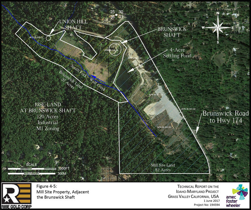
The Company has entered an Option Agreement with Sierra Pacific Industries, Inc. (SPI) for the option to purchase the Mill Site Property (“Mill Site”) directly adjacent the Brunswick land. The site was previously used for a commercial saw mill until 1991. All buildings and machinery have subsequently been removed. The Company has paid a total deposit of USD$300,000 to SPI in exchange for the rights to purchase the Mill Site for an additional USD$1,600,000 on or before June 30th, 2017 to acquire an undivided 100% interest in and to the Mill Site Property. The Company intends to purchase the Mill Site Property as the additional surface land will be complementary to the exploration and future development of the Idaho-Maryland Gold Project. The Mill Site has a leveled area of approximately 40 acres and a ~4-acre settling pond. The settling pond is located adjacent to the Brunswick Mine shaft.
The Mill Site Property surface rights include approximately 82 acres (33 hectares) of fee simple land located in portions of Section 31, Township 16 North – Range 9 East MDM and Section 36, Township 16 North – Range 8 East MDM as detailed in Table 4-4 and displayed in Figure 4-5. Parcels 06-441-03 and 06-441-34 are located within the City of Grass Valley’s planning area boundary, within the “Long-term” Sphere of Influence. Parcels 06-441-04 and 06-441-05 are located outside the City of Grass Valley’s Sphere of Influence. The City of Grass Valley Sphere of Influence was previously described in Section 4.2.1.2 of this Report.
| Project No.: 194594 | Page 4-15 | |
| | Technical Report on the Idaho-Maryland Project Grass Valley California, USA |
Table 4-4: Mill Site Property – Surface Land Legal Description
| Parcel Number | Description | Lot Size | ||
| 06-441-03 | SEC 31, TWN 16N, RNG 9E, MDM, PTN NW 1/4 of 31-16-9 | 15.19 AC | ||
| 06-441-04 | SEC 31, TWN 16N, RNG 9E, MDM, PTN 31-16-9 | 0.85 AC | ||
| 06-441-05 | SEC 31, TWN 16N, RNG 9E, MDM, PTN W 1/2 of 31-16-9 | 50.01 AC | ||
| 06-441-34 | SEC 31, TWN 16N, RNG 9E, MDM & SEC 36, TWN 16N, RNG 8E, MDM, PTN LOT 8 BET ACRES | 16.01 AC |
The parcels comprising the Mill Site Property have a combined annual property tax of $3,069.00 for the fiscal year ending June 30th, 2017. The total amount includes County taxes and Agency taxes.
Each of the parcels of the Mill Site land are positioned within Nevada County’s “M1” Light Industrial Zone. Light Industrial Zoning type is detailed previously in Section 4.2.1.2 of this Report.
Details of previous environmental studies on the Property are discussed in Section 24 of this Report.
| Project No.: 194594 | Page 4-16 | |
| | |
| Page 4-17 |
| | Technical Report on the Idaho-Maryland Project Grass Valley California, USA |
| 4.4 | Environmental Liabilities |
Environmental studies have been completed on all the surface holding owned or under option by Rise. The environmental studies were completed prior to the Company purchasing the Idaho land and Brunswick land and prior to the Company securing an option to purchase the Mill Site land.
| 4.4.1 | Idaho Land |
In 2016 a Draft Preliminary Endangerment Report on the Idaho Land was prepared for the City of Grass Valley by Geocon Consultants Inc. This report provided conclusions and recommendations to support redevelopment of this site for commercial and industrial use. Geocon noted the metal of greatest concern with respect to potential health risks for future site occupants is arsenic which is present is mine tailings and waste berms located on the site. Geocon noted that the presence of arsenic in mine waste on the site does not currently appear to pose a significant risk to public health or the environment in its current state and that an expedited response action does not appear warranted at this time (Geocon, 2016).
| 4.4.2 | Brunswick Land |
In 2007 a Phase I Environmental Site Assessment for the Round-Hole and New Brunswick Mine Sites was prepared by Engineering/Remediation Resources Group, Inc. (ERRG) for Idaho-Maryland Mining Corporation. The report concluded that there were no current recognized environmental conditions1 (RECs) on the Property at the time, although there are suspect environmental concerns regarding spills of hydrocarbons from vandalism at the New Brunswick Shaft, roofing asphalt on the property, debris from illegal dumping on the property boundaries, and the potential for naturally occurring asbestos in serpentinite rocks on the property. ERRG did not complete an analysis to determine if contamination from historic mining and mineral processing was present, although ERRG has recommended further sampling and studies to determine this (ERRG, 2007).
| 1 | ASTM defines the recognized environmental condition (REC) in the E1527-13 standard as “the presence or likely presence of any hazardous substance or petroleum product in, on, or at a property: (1) due to release to the environment; (2) under conditions indicative of a release to the environment; or (3) under conditions that poses a threat of a future release to the environment” (ASTM, 2017). |
| Project No.: 194594 | Page 4-18 | |
| | Technical Report on the Idaho-Maryland Project Grass Valley California, USA |
| 4.4.3 | Mill Site Land |
In 2006 a Phase II Environmental Site Assessment (ESA) for the Mill Site was completed by Geomatrix Consultants Inc. for Sierra Pacific Industries, Inc. Extensive reclamation and environmental work had previously taken place on the Mill Site. There is mine waste rock on the property which has elevated arsenic levels however Geomatrix concluded that this rock is not discharging elevated metals into the local watershed. Ground water samples taken on the site as part of the ESA had residual Volatile Organic Compounds (VOC). The evaluation concluded that the residual VOC contamination presents no threat to human health from vapor migration to indoor air. The property has a deed restriction which restricts the use of groundwater for any domestic purpose and the construction of wells for the purpose of extracting water unless expressly permitted by the Regional Water Board (Geomatrix, 2006).
| 4.5 | Permits |
The following section details permit requirements, to the extent known, for surface exploration drilling. Rise is planning a preliminary exploration diamond drilling program from surface with planned drill collars located on its Brunswick land near the Union Hill and Brunswick shafts.
Exploration diamond drilling on M1-Industrial Land is an allowed use and does not require a discretionary permit provided that no water is discharged offsite and disturbance per site is less than 1 acre and 1,000 yd3 material (NCC, 2017).
| 4.5.1 | Permit Requirements for Surface Exploration Drilling |
All parcels included in the Idaho-Maryland Mine Property and Mill Site Property are within the “M1” Light Industrial Zoning District of Nevada County. Mineral exploration is allowed in M1 Districts subject to zoning compliance and building permit issuance, if required. A Use Permit is only required for mineral exploration if one of the following conditions are triggered, as per NCC § L-II 3.22(D)(2):
| (a) | Overburden or mineral deposits in excess of 1,000 cubic yards are disturbed, or |
| (b) | The operation in any one location exceeds one acre in size, or |
| (c) | Dewatering will occur or water will be discharged from the site as a result of the operation. |
| Project No.: 194594 | Page 4-19 | |
| | Technical Report on the Idaho-Maryland Project Grass Valley California, USA |
Additionally, all exploratory operations shall require a reclamation plan and secure adequate financial assurances to ensure site reclamation unless:
| (a) | Less than 1,000 cubic yards of overburden are disturbed, and |
| (b) | The size of the operation in any one location is one acre or less. |
In those instances, where a reclamation plan is not required, an erosion control plan as per NCC § L-V 13.14., approved by the Nevada County Planning Department, and a grading permit shall be required for those operations in which 50 cubic yards or more of overburden are disturbed as per NCC § L-II 3.22(D)(2) (NCC, 2017).
A building permit, issued by the County, may be required for construction of drilling facilities. A building permit is a ministerial approval. Ministerial approval is a non-discretionary approval such that the County issues the permit when the requirements are met.
| 4.5.2 | Nevada County Noise Regulation |
The Noise Element of the Nevada County General Plan (2014) establishes maximum allowable exterior noise levels for various land use categories in terms of the average-hourly noise (Leq) and maximum intermittent noise (Lmax). Maximum allowable noise standards are identified for daytime (7:00 AM to 7:00 PM), evening (7:00 PM to 10:00 PM), and nighttime (10:00 PM to 7:00 AM) periods (NC-BOS, 2014).
For M1-Industrial Land, the noise standard is less than Leq = 80dBA and Lmax = 90dBA during all hours of the day. Where Rise’s M1 zoned land abuts residential zoned lots, the noise standard at this boundary would be as per the zoning of the adjacent lot. At the planned Union Drill site the adjacent lot is zoned RA. The noise standards for RA zoning are as follows (NC-BOS, 2014):
7am-7pm – Leq=55dBA, Lmax=75dBA
7pm-10pm – Leq=50dBA, Lmax=65dBA
10pm-7am – Leq=45dBA, Lmax=60dBA
Rise plans to have a robust noise monitoring plan and procedures to ensure that exploration operations are fully compliant with Nevada County noise standards.
| Project No.: 194594 | Page 4-20 | |
| | Technical Report on the Idaho-Maryland Project Grass Valley California, USA |
| 4.5.3 | Union Surface Exploration Drill Site |
Rise plans on conducting exploration diamond drilling from its I-M Mine Property on the Brunswick land, APN 09-630-37, located on East Bennett Road, Grass Valley, California.
Parcel APN 09-630-37 is in Nevada County and has an M1-Industrial Zoning. The proposed surface exploration drill site has been named the Union Drill Site.
Overburden disturbance required to support Rise’s proposed drill site is expected to be less than the 1,000 yd3 threshold and total area of each site is expected to be less than one acre. All water will be recycled on site. No Permits or reclamation securities are expected to be required for this exploration work program.
| 4.5.3.1 | Access and Drill Site |
Access to the proposed Union drill site will be from the existing driveway off East Bennett Road. This driveway will require some minor leveling and some rock or gravel surfacing.
The drill site is in a pre-existing leveled clearing with dimensions of approximately 100ft x 100ft (0.25 acres). Only minor brushing will be required to reopen the clearing and access the driveway.
Rise will use a skid mounted exploration diamond drill to conduct exploration drilling of the Idaho-Maryland gold deposit.
The diamond drill rig is contained in a pre-manufactured steel “drill shack” which is insulated for sound absorption and has a sliding door.
Noise levels of the diamond drill are estimated to be approximately 90dB. East Bennett Road is approximately 100ft (30m) from the drill site and the nearest residence is approximately 300ft (91m) from the drill site.
Based on the inverse square law for sound with no noise barrier, noise levels from surface drilling are expected to be approximately 66dB at E. Bennett Road and 57dB at the nearest residence (NC-BOS, 2014). Rise plans to use multiple forms of sound barriers, such as an enclosed drill shack and sound control panels, to reduce noise levels below Nevada County standards. Noise monitoring will be conducted by the Company to ensure that the exploration drilling complies with regulations of Nevada County.
| Project No.: 194594 | Page 4-21 | |
| | Technical Report on the Idaho-Maryland Project Grass Valley California, USA |
Commonly, diesel powered engines are utilized for diamond drilling. As an alternative, the Company will investigate electric powered drills to decrease noise levels created by diamond drilling and the associated power requirements for the exploration program.
| 4.5.3.2 | Water Management |
Rise will utilize a closed-circuit water system consisting of a mobile Solids Removal Unit (“SRU”). This unit will be used to remove drill cuttings from the drill water and recirculate water back to the drills. No discharge of water from exploration drilling will be required as all water is in a closed circuit with the drill and SRU.
Drill cuttings will be transported and disposed offsite. Drill cuttings will primarily be composed of ground andesite rock.
The drill will recirculate approximately 12 gallons per minute (GPM) of flow. The drill is expected to require approximately 2 GPM of make-up water to account for fluid lost to evaporation and moisture content of dried drill cuttings. Make-up water will be sourced from either the Nevada Irrigation District or from the Union Hill shaft which is nearby the drill site. Water requirements for make-up water are very small and no dewatering of the Union Hill Mine Shaft will take place or is contemplated.
| 4.6 | Additional Details Regarding Permitting |
Rise is focused on mineral exploration at the Idaho-Maryland Mine and is not contemplating the permitting or re-opening of the I-M Mine at this time. Permit requirements, for the planned exploration program proposed in Section 26.0 of this Report, are discussed in Section 4.5 of this Report.
A preliminary review of the regulatory framework for permitting an underground mine in Nevada County, California was completed by Rise and is discussed in the following Section.
The Project area is all on private land and no permits or consultations with the US Bureau of Land Management (BLM) or the US Forest Service (USFS) would be required.
| Project No.: 194594 | Page 4-22 | |
| | Technical Report on the Idaho-Maryland Project Grass Valley California, USA |
| 4.6.1 | Nevada County Use Permit and CEQA |
All of the Rise surface holdings are located on private land zoned M1 Industrial Land in Nevada County and are outside of the city limits of Grass Valley.
Nevada County would likely be the lead agency for permitting of an underground mine. However, both parcels fall within the City of Grass Valley’s Sphere of Influence. As such, the County may consult with the City before authorizing uses within the Sphere of Influence. During the previous Emgold permitting applications, which were focussed on the Idaho land adjacent to the City of Grass Valley, the City of Grass Valley became the lead agency and proposed to annex the project into the City.
Subsurface mining is allowed in the Nevada County M1 Zoning District with approval of a Use Permit as per NCC § L-II 3.21. (NCC, 2017). Approval of a Use Permit for mining operations requires a noticed public hearing before the County Planning Commission, which the decision may be appealed to the County Board of Supervisors as per NCC § L-II 5.6. (NCC, 2017). Use Permit approvals include conditions of approval, which are designed to minimize the impact of conditional uses on neighboring properties.
In 1975, the California Legislature enacted the Surface Mining and Reclamation Act (“SMARA”), which required that all surface mining operations in California have approved reclamation plans and financial assurances. SMARA was adopted to ensure that land used for mining operations in California would be reclaimed to a useable condition as per PRC § 2711. (CPRC, 1975). Pursuant to SMARA, Rise would be required to obtain approval of a Reclamation Plan and financial assurances from the County for any surface component of the underground mining operation before mining operations could commence as per PRC § 2770. (CPRC, 1975). Approval of a Reclamation Plan will require a public hearing before the County Planning Commission.
To approve a Reclamation Plan and Use Permit, the County would need to satisfy the requirements of California Environmental Quality Act (CEQA). CEQA requires that public agency decision makers study the environmental impacts of any discretionary action, disclose the impacts to the public, and minimize unavoidable impacts to the extent feasible. CEQA is triggered whenever a California governmental agency is asked to approve a “discretionary project” as per PRC §21080(a). (CPRC, 1979). The approval of a Reclamation Plan is a discretionary project under CEQA. Other necessary ancillary permits like the California Department of Fish and Wildlife (CDFW) Streambed Alteration Agreement (if applicable) also triggers CEQA compliance.
| Project No.: 194594 | Page 4-23 | |
| | Technical Report on the Idaho-Maryland Project Grass Valley California, USA |
In this situation, the lead agency for the purposes of CEQA would be the County. Other public agencies will also need to approve aspects of the Project, such as CDFW (California Endangered Species Act compliance), APCD (Authority to Construct and Permit to Operate), and RWQCB (NPDES and Report of Waste Discharge). However, CEQA’s Guidelines provide that if more than one agency must act on a project, the agency that acts first is generally considered the lead agency under CEQA (CEQA, 1992). All other agencies are considered “responsible agencies.” Responsible agencies do need to consider the environmental document approved by the lead agency, but will usually accept the lead agency’s document and use it as the basis for issuing their own permits.
| 4.6.2 | Major Permits Required for an Underground Mine |
Subsurface mining, including ancillary surface uses, may require the following County permits and approvals.
County Approvals
| (a) | Use Permit for surface and subsurface mining activities. |
| (b) | Reclamation Plan for surface disturbance. |
| (c) | Mitigated Negative Declaration or Environmental Impact Report in compliance with the California Environmental Quality Act (“CEQA”) to analyze and mitigate environmental impacts. |
| (d) | Water Well Permit by the County for the drilling of any well. |
| (e) | Building Permits for construction of any structures. |
| (f) | Spill Prevention Control and Countermeasures Plan for underground storage of more than 42,000 gallons of petroleum or above ground storage of more than 10,000 gallons of petroleum. |
In addition, the following Agency permits and approvals may also be required depending on the configuration of the Project and the characteristics of the natural resources found in the Project vicinity.
California Department of Fish and Wildlife (“CDFW”) Approvals
| (a) | Streambed Alteration Agreement. |
| Project No.: 194594 | Page 4-24 | |
| | Technical Report on the Idaho-Maryland Project Grass Valley California, USA |
| (b) | Incidental Take Permit for take of any species listed under the California Endangered Species Act (“CESA”). |
State Water Resources Control Board (“SWRCB”) and/or Central Valley Regional Water Quality Control Board (“RWQCB”) Approvals
| (a) | National Pollution Discharge Elimination System (“NPDES”) permit for discharges of storm water. |
| (b) | Report of Waste Discharge for any discharges of water from mining processes. |
| (c) | Clean Water Act Section 401 Water Quality Certification from the RWQCB (only if a CWA Section 404 permit is required from the U.S. Army Corps of Engineers). |
U.S. Army Corps of Engineers (“Corps”)
| (a) | Clean Water Act Section 404 permit for any discharge of dredge or fill material into the waters of the United States. |
| (b) | Environmental Assessment compliant with the National Environmental Policy Act by either the Corps or the USFWS. |
United States Fish and Wildlife Service (“USFWS”)
| (a) | Issuance of a Biological Opinion and Incidental Take Statement for take of any species listed under the Endangered Species Act. |
Northern Sierra Air Quality Management District (“AQMD”)
| (a) | Authority to Construct and Permit to Operate for any regulated air pollutant emitting sources such as diesel generators. |
| 4.6.3 | Nevada County – Recent Permit Examples |
Nevada County has an extensive history of gold mining. Prospecting began during the California Gold Rush in the 1840’s and continues to this day. Historic mining districts, including Grass Valley-Nevada City, You Bet, Red Dog, and French Corral Districts, are located throughout the County and provide visual evidence of the County’s extensive mining history.
| Project No.: 194594 | Page 4-25 | |
| | Technical Report on the Idaho-Maryland Project Grass Valley California, USA |
According to the CDC Division of Mining Reclamation Assembly Bill (AB) 3098 List, there are currently six mines (aggregate mines) in Nevada County regulated under SMARA (CDC, 2017), pursuant to Public Resources Code Section 2717(b). The AB 3098 List published in April 2017 lists 841 mines in California State; mines listed include all types of mines that have at least some surface component (CDC, 2017). In addition, Nevada County adopted a MND and approved the Blue Lead Gold Mine in 2015.
Blue Lead Gold Mine
The Nevada County Board of Supervisors approved the Blue Lead Gold Mine (“Blue Lead”) at a public hearing in April 2015. The Board of Supervisors approved the Blue Lead project through a unanimous vote (4-0, one absence). The Conditional Use Permit (CUP) adopted by the County for the project provides for surface extraction of placer gold deposits and subsequent reclamation on an ~74 acre site, located seven (7) miles east of Nevada City.
Permitting for Blue Lead Project included a reclamation plan, pursuant to California’s Surface Mining and Reclamation Act of 1975. The County complied with the California Environmental Quality Act (CEQA) by preparing a Mitigated Negative Declaration (MND) to study the potential environmental impacts of the Project. The County did not require the Project applicants to prepare a more expensive Environmental Impacts Report (EIR) for the Project which demonstrates the County’s willingness to consider and support applications for mining projects. The Blue Lead Gold Mine has all County Permits necessary to commence mining operations.
| 4.7 | Other significant risks |
No significant factors or risks are known to exist other than those discussed in this report, which would affect access, title, or the right or ability to perform exploration work on the Property.
| Project No.: 194594 | Page 4-26 | |
| | Technical Report on the Idaho-Maryland Project Grass Valley California, USA |
| 5.0 | ACCESSIBILITY, CLIMATE, LOCAL RESOURCES, INFRASTRUCTURE AND PHYSIOGRAPHY |
| 5.1 | Accessibility |
The Idaho-Maryland Mine Property is situated east of the City of Grass Valley and south of Nevada City, in western Nevada County. State Route 49, State Route 20, and State Route 174 (state highways) connect the Grass Valley area regionally. The location of the Property is displayed previously in Figure 4-2.
The Brunswick land, and adjacent Mill Site, are situated on the southwest quadrant of the intersection of East Bennett Rd, a two-lane artery, and Brunswick Rd, a major two-lane artery connecting Grass Valley with State Highway 174. Access to the Brunswick land is on Millsite Rd via the East Bennett Rd, approximately 2.8 miles east of Grass Valley center. South Fork Wolf Creek (“SF Wolf Creek”) flows northwest through the Brunswick land.
The Idaho land is situated along Idaho Maryland Rd, to the south, centred between Railroad Ave. and Brunswick Rd. Idaho land can be accessed by Idaho Maryland Road or Centennial Drive and multiple trails are present across the property. Wolf Creek flows west through the north side of the Idaho land.
| 5.2 | Climate |
The Mediterranean – Subtropical Dry Summer climate of Grass Valley is typical of northern California, characterized by sharply defined seasons. The area experiences high temperatures, constant sunshine, and dry air in the summer and cold piercing north winds, possibility of snow, and thick fog in the winter. Grass Valley is located in Climate Zone 11 as defined by the California Energy Commission which encompasses northern California, south of the mountainous Shasta Region, east of the Coastal Range, and west of the Sierra Cascades (CEC, 1995).
The average temperatures range from 43°F in January to 72°F in July. Grass Valley has an average annual precipitation of 54 inches, which is mainly rainfall. The weather statistics are representative of the past 30 years (1981-2010) from the Grass Valley Number 2, CA US GHCND:USC00043573 weather station located at 39°12’14.76“N, 121°4’4.8“W (NOAA, 2017). The 1981-2010 Climate Normals are NOAA’s latest three-decade averages of climatological variables, including temperature and precipitation which are presented in Table 5-1 and shown in Figure 5-1 and Figure 5-2.
| Project No.: 194594 | Page 5-1 | |
| | Technical Report on the Idaho-Maryland Project Grass Valley California, USA |
Grass Valley, California has had an average annual snowfall of 8.0 in over the last 30 years (1981-2010). Historically, Grass Valley receives the most snow in February, at 2.7in (NOAA, 2017).
Based on the mild climate, operations of any type could occur year-round at the Idaho-Maryland Mine Property.
| Table 5-1: | Grass Valley Temperature and Precipitation Climate Normals for Period 1981 to 2010 (NOAA, 2017) |
| Temperature | Precipitation | |||
| Month | Mean (°F) | Min (°F) | Max (°F) | Average (In) |
| January | 42.9 | 32.7 | 53.1 | 8.88 |
| February | 44.4 | 34.3 | 54.6 | 9.02 |
| March | 47.5 | 37.1 | 57.9 | 8.06 |
| April | 51.4 | 40.1 | 62.7 | 4.02 |
| May | 58.6 | 46.2 | 70.9 | 2.38 |
| June | 65.8 | 52.1 | 79.5 | 0.62 |
| July | 72.1 | 56.9 | 87.2 | 0.01 |
| August | 71.1 | 55.5 | 86.7 | 0.16 |
| September | 66.1 | 50.9 | 81.2 | 0.86 |
| October | 57.4 | 43.6 | 71.3 | 2.84 |
| November | 47.8 | 36.8 | 58.9 | 6.57 |
| December | 42.4 | 32.6 | 52.3 | 10.32 |
| Average | 55.6 | 43.2 | 68.0 | 4.5 |
| Total Precipitation (In) | 53.74 | |||
| Project No.: 194594 | Page 5-2 | |
| | Technical Report on the Idaho-Maryland Project Grass Valley California, USA |
Figure 5-1: Grass Valley Precipitation Data for Period 1981 to 2010 (NOAA, 2017)
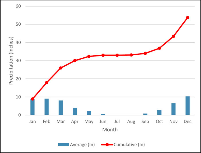
Figure 5-2: Grass Valley Temperature Data for Period 1981 to 2010 (NOAA, 2017)
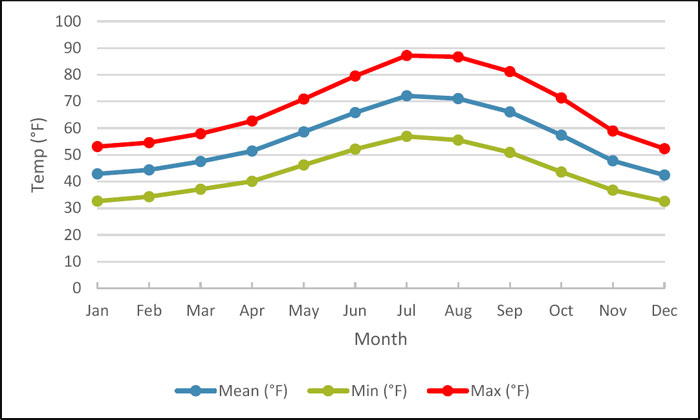
| Project No.: 194594 | Page 5-3 | |
| | Technical Report on the Idaho-Maryland Project Grass Valley California, USA |
| 5.3 | Physiography |
The I-M Mine Property, including the Mill Site land, is characterized by low rolling hills with elevations between approximately 2,490ft and 2,923ft (759m and 891m) above mean sea level (AMSL). Collar elevation of the New Brunswick Shaft is 2752.3ft (838.9m) AMSL.
The Property is located in the Sierra Nevada physiographic province of California. The Sierra Nevada separates the Great Central Valley from the Basin & Range. The Sierra is a tilted fault block nearly 400 miles long and between 40 to 80 miles wide. Its east face is a high, rugged multiple scarp, contrasting with the gentle western slope that disappears under sediments of the Great Valley (CGS, 2002).
The Property is situated in the North Sierran Ecological Province (CALVEG Zone 3). The ecology surrounding Grass Valley is diverse and complex as it is located in a transition zone between the lower foothill elevations and the higher Sierra Nevada mountains. The Grass Valley area is vegetated with grasslands of mostly non-native grasses, mixed grasslands and woodlands savanna, a foothill woodland community of blue oak and gray pine, and chaparral. Additionally, the Property is located within the Wolf Creek drainage basin (USDA, 2017).
The Brunswick land is partially wooded with open grassy areas while the Idaho land is mostly wooded with some grassy areas.
| 5.4 | Local Resources and Infrastructure |
The I-M Project is located within several miles of the City of Grass Valley. Grass Valley is a city of approximately 12,000 people with many skilled workers and numerous services available. Grass Valley no longer has a large pool of resident underground mining specialists but there is a large workforce of mining specialists in Reno and Nevada State, which is relatively close by.
Additional details pertaining to underground mine access, development rock, underground void space, mill tailings, and water discharge are further described in Section 24 of this Report.
| Project No.: 194594 | Page 5-4 | |
| | Technical Report on the Idaho-Maryland Project Grass Valley California, USA |
| 5.4.1 | Surface Rights |
There are two main areas of surface holdings for the project, a 119 acre site on the south-east of the mine at the Brunswick shaft (Brunswick land and Mill Site land) and a 52 acre site northwest of the mine near the Idaho #1 Vein.
The Idaho land is adjacent to the City of Grass Valley and beyond the western boundary of the exploration targets at the I-M Mine. It is anticipated that this land will be less useful than the Brunswick land for exploration or development of the I-M Project. The Idaho land does, however, provide access to the main Wolf Creek which is larger and has significantly more flow than SF Wolf Creek on the Brunswick Land.
In the Brunswick area, Rise owns 37 acres of land and has the option to purchase an adjacent 82 acres, the Mill Site, for a total of 119 acres. The Mill Site includes a levelled and previous disturbed zone adjacent to the Brunswick shaft, with a surface area of approximately 40 acres, provides adequate surface rights for exploration and future building sites. Regions outside this 40-acre zone are likely not suitable as building sites and provide a buffer zone to adjoining properties. These buffer areas include: a riparian area within 100ft (30m) of SF Wolf Creek, wetlands adjacent to SF Wolf Creek, 4 acre recycle pond, and forested hillside on the south end of the Property.
The following features are important to note regarding the Brunswick Site;
| 1) | New Brunswick vertical shaft. A three-compartment rectangular shaft with 4ftx4ft compartments. The ultimate shaft depth is 3,470ft (1,058m) and has many connections to the Brunswick Mine levels, loading pockets, and sumps as displayed in Figure 5-3. The shaft had a hoisting capacity of over 1,000 tons per day with a single skip and cage configuration. The shaft rails were constructed of flawless Port Orford cedar and were reported to be in good condition below the water line by Emgold during an underwater filming in 1991. The shaft previously had a 135ft (41m) high headframe which hoisted at speeds of 1250ft/min. A concrete rock silo remains adjacent to the shaft and the shaft is covered by a secure and locked steel plate. All other structures have been removed. The land that would be required to re-erect a shaft headframe remains as part of the surface land holdings. |
| 2) | The Mill Site land previously hosted a major commercial lumber mill until 1991. All buildings have subsequently been removed. The mill site previously hosted 55,000ft2 of industrial buildings (Willdan Associates/PMC, 1995). |
| 3) | The adjacent Mill Site has a recycle pond which was constructed in 1988 and used to collect spray runoff from the lumber mill. The pond has a surface area of approximately 3.7 acres and a design capacity of approximately 40 acre-feet. The pond is believed to be lined with a |
| Project No.: 194594 | Page 5-5 | |
| | Technical Report on the Idaho-Maryland Project Grass Valley California, USA |
| single 2ft layer of clay and designed by a registered civil engineer (Willdan Associates/PMC, 1995). |
| Project No.: 194594 | Page 5-6 | |
| | Technical Report on the Idaho-Maryland Project Grass Valley California, USA |
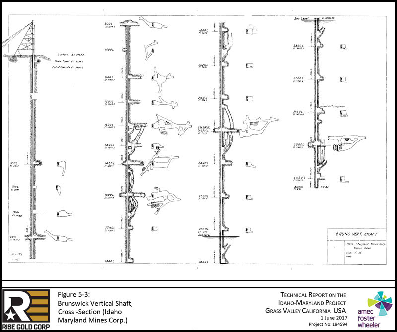
| Project No.: 194594 | Page 5-7 | |
| | Technical Report on the Idaho-Maryland Project Grass Valley California, USA |
| 5.4.2 | Electrical Power |
The electrical grid system in the Project area is well developed and likely adequate to support the I-M Project throughout its development. The commercial sawmill on the Mill Site was previously serviced by a dedicated 12kV power line and a high voltage power line also runs through the Property west of the Brunswick shaft. Re-electrification of the site will require planning and consultation with the power provider, PG&E, and the installation of onsite transformers.
| 5.4.3 | Water Supply |
Any future mining operation would have an abundance of water from the underground workings as natural groundwater inflows into the mine have been estimated at approximately 750 GPM (Willdan Associates/PMC, 1995). Water service from the Nevada Irrigation District is also available at the Property.
| 5.4.4 | Roads |
The Brunswick Site can be accessed from E. Bennett Road or Brunswick Road. The Mill Site previously accommodated heavy traffic from logging trucks but has not been in operation for over 25 years. Brunswick Road is a two to three lane road and one of the most heavily travelled Nevada County maintained roadways with approximately 15,300 average daily trips (ADT) (NCTC, 2015).
State Route 49 can be reached driving north along Brunswick Road towards Grass Valley and State Route 174 can be reached driving south along Brunswick Road. State Route 174 leads to Colfax and State Highway 80.
A figure showing the main road access with average daily trips to the Brunswick Site is shown in Figure 5-4.
| Project No.: 194594 | Page 5-8 | |
| | Technical Report on the Idaho-Maryland Project Grass Valley California, USA |
| 5.5 | QP Comment |
There are sufficient surface rights, available power, water, processing plant, and personnel to support the drill program proposed herein and for the future development of a mine. There is limited surface rights for storage of tailings and waste. Future mine planning will need to consider underground storage or trucking of tails and waste to another location.
Figure 5-4: Main Access Roads showing Average Daily Trips to Brunswick Site (DOT, 2015)
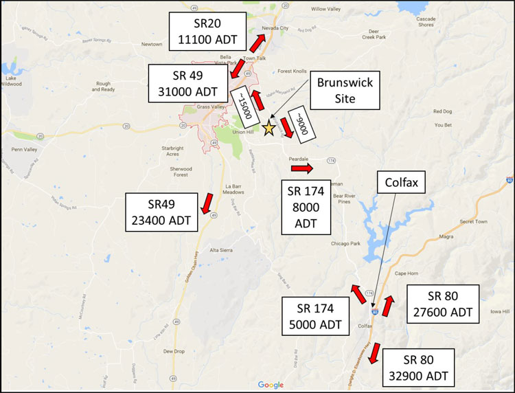
| Project No.: 194594 | Page 5-9 | |
| | Technical Report on the Idaho-Maryland Project Grass Valley California, USA |
| 6.0 | HISTORY |
| 6.1 | History of the Idaho-Maryland Mine Property |
| 6.1.1 | Grass Valley – Nevada City Mining District |
The gold-quartz mines of the Grass Valley – Nevada City District in Nevada County have been the most productive in the State of California. The mines in this district were known in California as the “Northern Mines”. Placer deposits in the Grass Valley – Nevada City District were first discovered during the gold rush of 1849 and subsequently gold was discovered in the quartz veins of Gold Hill in 1850.
The total gold production of Nevada County from 1849 through 1959 is estimated at 12.6M oz with 10.4M oz of lode gold and 2.2M oz of placer gold. (Koschmann & Bergendahl, 1968). The Grass Valley – Nevada City District was the third largest gold camp in the United States through to 1959, as shown in Figure 6-1 (Koschmann & Bergendahl, 1968).
The Empire, North Star, and Idaho-Maryland Mines have accounted for more than two-thirds of the Grass Valley production and had considerable influence on the economic life of the community. An estimated 5.8M oz gold was produced from the Empire-Star Mine and 2.4M oz gold from the Idaho-Maryland Mines. The two highly productive mines are only separated by approximately 2 miles. Empire Mine was in continuous operation from 1850 to 1956 except for the forced shutdown during WWII.
| Project No.: 194594 | Page 6-1 | |
| | Technical Report on the Idaho-Maryland Project Grass Valley California, USA |
| Figure 6-1: | Gold Production (to nearest 1,000oz) of 25 Principal Gold-Mining Districts of the United States – through 1959 (Koschmann & Bergendahl, 1968) |
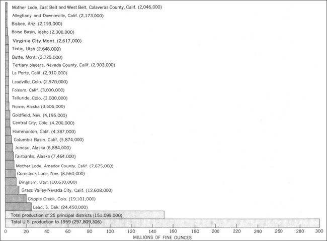
| 6.1.2 | Idaho-Maryland Mine Property |
The Idaho-Maryland Mine, located in the Grass Valley mining district of northern California was one of the most productive and best known gold mines in the Unites States, with gold production from the property dating back to 1863.
The Idaho-Maryland Mine, as it now exists, represents a consolidation of a number of important early day producing mines including Eureka, Idaho, Maryland, Brunswick, and Union Hill Mines. Based on historic production records, the I-M Mine produced a total of 2.4M oz gold at an average mill head grade of approximately 0.5oz/ton (17.1gpt). The I-M Mine was reportedly the second largest gold mine in the United States in 1941 (Clark, 2005), producing up to 129,000 oz gold per year before being forced to shut down by the US government in 1942 (Shore, 1943). Due to lack of development, a decline in gold production was experienced and recovery from war-time shutdown never occurred.
| Project No.: 194594 | Page 6-2 | |
| | Technical Report on the Idaho-Maryland Project Grass Valley California, USA |
The Idaho-Maryland Mine has a rich history of mining work completed between 1863 and 1956 by various operators. The Property and its comprehensive collection of original documents was rediscovered in 1990 and efforts were made to reopen the historic mine; however, the operator was unsuccessful due to inability to raise necessary funding in unfavourable market conditions. The information presented here within has drawn from the history previously described in multiple reports of the Property and Jack Clark’s book Gold in Quartz. Gold discovery, mining activity, and significant events, in addition to ownership of the property and ownership changes, are described chronologically for the important gold veins that constitute the Idaho-Maryland Mine Property.
| 6.1.2.1 | Eureka Mine |
| 1851 | Eureka outcrop, marked by conspicuous white quartz, was discovered on the Eureka mining claim. The outcrop of low-grade gold quartz was working at intervals until 1857. |
| 1857 | The mine is purchased by Fricot and others, and is worked at a loss until 1863. |
| 1863 | Vertical shaft was sunk to a depth of 100ft (30m) at the Eureka Mine where a rich ore shoot was discovered, averaging $28/ton. (1.35oz/ton, 45gpt) |
| 1865 | Eureka Gold Mining Company purchased the Eureka Mine. Eureka Mine became leading gold-producer in the United States; maintained lead position until 1871. |
| 1867 | Between the 100-foot and 200-foot levels the ore averaged $37/ton (1.79oz/ton, 61gpt) and from 200-foot level down to 600-foot level the ore increased in value to $50/ton (2.41oz/ton, 83gpt)) over an average width of 3ft (1m). |
| 1877 | Eureka Gold Mining Co. failed to find additional resources; company forced to shutdown mine. |
| 6.1.2.2 | Idaho Mine |
| 1863 | Idaho claim recorded. Original discovery of Idaho Vein, the eastern extension of the Eureka Vein, believed to have been discovered in 1850s in the bed of Wolf Creek. |
| Project No.: 194594 | Page 6-3 | |
| | Technical Report on the Idaho-Maryland Project Grass Valley California, USA |
| 1865 | Shaft sinking operation commenced to intersect vein at 150ft (46m) below surface. Due to lack of capital, all work ceased in 1866. |
| 1867 | Idaho Quartz Mining Company, organized by the Coleman brothers, bought the Idaho Mine. Ore shoot struck at 300ft (91m) below surface. Subsequently a stamp mill was erected. By 1870, the Idaho shaft extended more than 600ft (183m) below surface. |
| 1870 | The Idaho shaft had been development more than 600ft (183m) below surface with levels developed at 100-foot intervals. |
| 1872 | Idaho Mine surpasses the Eureka Mine as the leading gold-producer in California. Held position until 1892. From 1868 to 1892, Idaho Quartz Mining Co. milled a total of 567,029 tons resulting in 574,434 oz of gold. |
| 1893 | Operations ceased as the mine reached their claim boundary to the east. Maryland Mine located in the adjacent claim. |
| 6.1.2.3 | Union Hill Mine |
| 1854 | Union Hill is discovered. |
| 1866 | James K. Byre’s claim for Union Hill Gold Quartz Mine was recorded. The mine worked profitably until 1870. |
| 1900 | Union Hill Mine reopened and operated until 1911. |
| 1914 | Mine was reopened again by Gold Point Consolidated Mines, Inc. and was operated until 1919. |
| 1918 | Union Hill Mine was purchased by Idaho-Maryland Mines Company. |
| 6.1.2.4 | Maryland Mine |
| 1865 | Maryland Mine claims were staked. |
| 1880 | Maryland Gold Quartz Mining Company was formed and commenced work on the Maryland Mine. |
| Project No.: 194594 | Page 6-4 | |
| | Technical Report on the Idaho-Maryland Project Grass Valley California, USA |
| 6.1.2.5 | Brunswick Mine |
Brunswick Mine was located in the mid 1800’s, although the exact date is unknown.
| 1888 | Brunswick Mine had only been worked to a depth of 300ft (91m) by an inclined shaft, Old Brunswick Shaft. |
| 1896 | The three-compartment inclined shaft had reached a depth of 700ft (213m) and later it continued to the 1250-foot level where extensive lateral development work was undertaken resulting in good ore discoveries. |
| 1915 | The Brunswick owners, Brunswick Consolidated Gold Mining Company constructed a new four compartment vertical shaft, the New Brunswick Shaft. Simultaneously, a steel head-frame and a complete 20-stamp mill and cyanide plant were installed. The method of handling and treating the ore was greatly improved and the operating costs materially reduced. |
| 6.1.2.6 | Idaho-Maryland Mine |
| 1894 | Maryland Gold Quartz Mining Co. purchases the Idaho Quartz Mining Co. and its Idaho Mine. The name is changed to Idaho-Maryland Mine. Subsequently, Dorsey (#2) Vein is discovered. |
| 1901 | Idaho-Maryland Mine closes due to insufficient capital. Total production of 60,282oz gold from 1894 to 1901. |
| 1902 | The Idaho Maryland Mine was bonded to Idaho Maryland Development Company. The Company sought out gold production from the upper levels of the mine as they completed surface repairs, mine dewatering, and shaft retimbering. |
| 1914 | Idaho Maryland Development Co. ceased operations at the beginning of WWI. Total gold production from 1904 to 1914 was 15,076 oz. |
| 1914 | Idaho-Maryland Mine interests the mining engineer Errol MacBoyle. Backed by various investors with controlling interest, MacBoyle acquires adjacent mining claims. |
| 1919 | The final property, the Idaho-Maryland Mine including Union Hill Mine, is acquired from the Dorsey family for $187,693. The Metals Exploration Company has controlling |
| Project No.: 194594 | Page 6-5 | |
| | Technical Report on the Idaho-Maryland Project Grass Valley California, USA |
interest in the consolidated group of mines. The Idaho-Maryland Mines Company is formed to operate the Idaho-Maryland Mine, while the Metals Exploration Co. continues to finance the operation. At the time, Union Hill Mine was the only mine in operation. Errol MacBoyle continues as consulting engineer for the operation.
| 1920 | Construction of the Idaho surface plant is completed; while underground operations focused on exploration of the Eureka-Idaho-Maryland (#1 Vein) below 1000L. |
| 1923 | A prospect drill is purchased and put into immediate use. |
| 1924 | The Idaho shaft sinking operation is completed to 2000L. Due to the large amount of underground development and significantly less gold production, the Company suffered a net loss. |
| 1925 | The Idaho-Maryland Mine is shut down. Subsequently, Errol MacBoyle set out to raise money to keep the pumps running and prevent the underground workings from being flooded. Total gold production from 1919 to 1925 was 9,676 oz. |
| 6.1.2.7 | Errol MacBoyle’s Era |
| 1925 | Errol MacBoyle and associates form holding company, Idaho Maryland Consolidated Mines, Inc., and make deal with Metals Exploration Co. to acquire the Idaho-Maryland Mine. Idaho Maryland Consolidated Mines, Inc. is holding company of Idaho-Maryland Mines Company. |
| 1926 | Under management of Errol MacBoyle, mine operations recommence under a tribute (lease) system. Gold production from the tribute miners kept the mill continuously running. |
| 1926 | MacBoyle (through Idaho Maryland Consolidated Mines, Inc.) acquired the adjacent property, the Brunswick Mine by secretly buying a majority of the shares. Brunswick operators, Brunswick Consolidated Gold Mining Company, capitulated allowing MacBoyle to take over. |
| 1927 | An old crosscut was extended which relocated the faulted No. 1900 Vein (#3 Vein). MacBoyle’s discovery of the strong vein finally brought success to Idaho-Maryland Mine after enduring financial hardship since re-opening the mine. |
| Project No.: 194594 | Page 6-6 | |
| | Technical Report on the Idaho-Maryland Project Grass Valley California, USA |
| 1930 | Discovery of #4 Vein which split off from the 1900 Vein (#3 Vein). By December 1931, the Company had paid off all its debts. Insufficient milling capacity (20 stamp mill) created restraints on underground production; Company begins modifying Brunswick mill to double gold production. |
| 1933 | Idaho Maryland Mines Co. leased the Brunswick Mine from Idaho Maryland Consolidated Mines Inc. Work commences to reopen Brunswick Mine. |
| 1934 | Price of gold increased from $20.37/oz to $35/oz. Enabled mining of “marginal” veins at a profit. Modernization of the Idaho-Maryland surface plant is completed, including addition of a new mill and cyanide plant. The new Idaho-Maryland mill is a huge success; plan to rebuild New Brunswick mill as an exact duplicate. |
| 1935 | Idaho Maryland Consolidated Mines Inc. merged with its opening company, Idaho Maryland Mines Co. to simplify the corporate organization. |
| 1936 | “Round Hole” shaft in Idaho Mine is completed to 1000L. The new 350 ton/day leaching plant was completed enabling production in the New Brunswick mill to increase to 500 tons/day. |
| 1937 | Old Brunswick Mine shut down for economic reasons; although, development work in Idaho and New Brunswick remained prosperous. Combined production averaged approximately 1000 tons/day – 300 tons from Idaho-Maryland mill and 700 tons from New Brunswick mill. |
| 1938 | Gold production greater than any other year in mine history. Idaho Maryland Mines Corporation (IMMC) achieved largest gold production in California with 117,000 oz gold produced. |
| 1940 | A connection was established between Idaho-Maryland Mine and New Brunswick Mine on 2300L (Brunswick). Development to deepen the New Brunswick shaft continued along with New Brunswick surface plant modernization work. Total gold production for 1940 was 129,000 oz. |
| 1940 | Details of I-M Mine are kept secret; Errol MacBoyle does not allow USGS into the mine. “The only mine of major importance to which access was not given is the Idaho-Maryland…”, “It is to be hoped that the geologic staff of the company will be permitted to publish the results of their studies pursued actively since 1931, for the Idaho-Maryland mine holds the key to the complex geology of the serpentine belt” (Johnston, 1940). |
| Project No.: 194594 | Page 6-7 | |
| | Technical Report on the Idaho-Maryland Project Grass Valley California, USA |
| 1942 | Modernized mill at New Brunswick placed back into production. Completion of New Brunswick headframe, crusher plant, hoists, and new compressors gave the corporation one of the finest and most efficient plants in the Country, “this equipment was designed to handle 2,000 tons a day from depths of 5,000 feet” (Pehrson & Needham, 1943). New Brunswick shaft sinking completed to 3,470ft (1,058m). Simultaneously, three new ore bodies are discovered. |
| 1942 | Manpower lost to the war effort which caused decreased production. As a result of WWII, US government issued Limitation Order L-208 requiring all gold mines to shut down. |
| 1943 | IMMC maintains minimal employees on payroll to keep underground pumps operating. Underground inspection of Idaho Mine 8 months after closure showed major damage; timbers had been weakened by decay and swelling of serpentine ground. Brunswick Mine remained in relatively good condition. |
| 1943 | In October, Errol MacBoyle suffered a stroke, paralyzing the right side of his body. |
| 1944 | IMMC was granted permission to produce a maximum of 7,800 tons of mineralized material per month. Mining was exclusively in the Brunswick Mine, while recapture and timber repair was completed in Idaho Mine. |
| 6.1.2.8 | Post-War Era |
| 1945 | Limitation Order L-208 was lifted by the US government. The Company re-established its workforce, although much smaller than pre-shutdown numbers and worked mainly in Brunswick Mine. |
| 1946 | Due to the loss of higher-value reserves in the Idaho Mine, it became necessary to increase development operations to find new veins and increase tonnage of the lower-grade Brunswick veins. To reduce operating costs, mining was completed through a tribute (lease) system. |
| 1948 | Costs to recapture caved raises and drifts became too expensive. All company work focused on development of a new vein, 52 Vein, on Idaho 2700L and #4 Vein in Brunswick. |
| Project No.: 194594 | Page 6-8 | |
| | Technical Report on the Idaho-Maryland Project Grass Valley California, USA |
| 1949 | New vein was discovered on Idaho 2400L by diamond drilling. Although, the vein was not developed because the company had insufficient development funds and there was no available underground space to dispose of waste rock. |
| 1949 | On November 4th Errol MacBoyle passed away in his sleep. |
| 1950 | A steel headframe was built to replace the old headframe at the Old Brunswick shaft. A connection between Idaho and Brunswick was established on 3280L (Brunswick). |
| 1952 | Development and exploration progressed in the hopes of discovering new ore close to existing workings while IMMC continued to operate at a loss. All leases in the mine were discontinued by September. |
| 1953 | Diamond drilling was continued in search of new veins and development work continued with limited funds. In November, employee reduction of surface and underground crews brought down the workforce to 90 people. Several parcels of unessential land were sold. |
| 1954 | A priority was given to explore the Idaho levels on 60 Winze, although there was no underground space to stockpile waste so the waste rock was moved as ore, causing dilution. |
| 1954 | Exploration for scheelite in 19 and 45 Veins was found to be sufficient to justify the installation of a mill. The Idaho mill was modified to extract tungsten. |
| 1955 | By May, all development work, except work involving tungsten exploration, was stopped. Mining was restricted to only stoping higher-grade quartz. By December, all mining and milling of gold was discontinued; operations focused only on production of tungsten. Tungsten exploration was subsidized by the US government. |
| 1956 | Company allowed mine to flood to 1450L and minimal tungsten production occurred near Union Hill Mine. In December, the California Division of Industrial Safety ordered Idaho Maryland Mining Co. to cease mining near the flooded Union Hill mine forcing the mine to shut down. |
| 1957 | Two-day auction held to liquidate mine equipment and structures. Auction sales enabled payment of all outstanding debts. |
| Project No.: 194594 | Page 6-9 | |
| | Technical Report on the Idaho-Maryland Project Grass Valley California, USA |
| 6.1.2.9 | Post-Production |
| 1963 | William and Marian Ghidotti purchase the Idaho-Maryland Mine property, including subsurface mineral rights, from Idaho-Maryland Industries Inc. (successor of Idaho Maryland Mining Co.) at an auction for the price of $52,500. |
| 1983 | The BET Group acquires the Idaho-Maryland Mine property, along with all mineral rights that Marian Ghidotti owned in connection with the Idaho-Maryland and Brunswick Mine Properties, through the “Ghidotti Estate Order”. The BET Group is comprised of three parties (1) Mary Bouma, (2) Erika Erickson, and (3) William Toms, each representing an undivided 1/3 interest. |
| 1990 | Consolidated Del Norte Ventures Inc. learns of the Idaho-Maryland Mine and historical collection of maps and documents secured by the BET Group. Company retains James Askew Associates, Inc. (JAA, Inc.) to complete a preliminary investigation of the mine records. Investigation concluded that sufficient geological evidence of the presence of gold-quartz-mineralization to warrant further investigation. |
| 1991 | Idaho-Maryland Mining Corporation (formerly Consolidated Del Norte Ventures Inc.) commissions JAA, Inc. to complete technical report on the property. |
| 1993 | Emperor Gold Corp. (through its subsidiary Idaho-Maryland Mining Corporation) secures a mining lease and option to purchase 100% interest in the Idaho-Maryland Property from the BET Group. The consideration for the 7 year lease is a minimum royalty of US$100,000 per year subject to consumer price index adjustment and a net smelter royalty (ranging from 4% to 8%) in any calendar month. The option agreement is to purchase the mine for US$8,000,000 net of option payments, along with minimum royalty and production payments. |
| 1994 | Emperor Gold Corp. signs an option to purchase for $2,000,000 USD with Sierra Pacific Industries for 82acre land at Brunswick Rd and East Bennett Rd (Mill Site Property). |
| 1995 | An Environmental Impact Report (EIR) was completed to dewater and explore the mine. Nevada County accepts application and grants permits. However, in the late 1990’s the permits to dewater the mine were cancelled or expired. |
| 2002 | Emgold Mining Corporation (formerly Emperor Gold Corp.) renegotiated the terms and conditions of a lease option to purchase agreement (BET Agreement). |
| Project No.: 194594 | Page 6-10 | |
| | Technical Report on the Idaho-Maryland Project Grass Valley California, USA |
| 2003 | Emgold acquires licensing rights to “Ceramext”, a ceramics technology process. Emgold plans to utilize technology by making ceramic tiles from mine tailings and waste rock. |
| 2004 | Emgold completed a surface exploration program on the Idaho-Maryland Mine property. Included 21,335ft (6,502m) of diamond drilling from twenty-six (26) drill holes and approximately 3,537ft (1,078m) of geotechnical drilling. Subsequently, an NI 43-101 Preliminary Assessment Technical Report was prepared by AMEC on the I-M Project describing the staged development of the project to reopen the mine and construction of a commercial ceramics production facility. |
| 2005 | Emgold commenced permitting of the I-M Project to construct a commercial ceramics production facility and reopen the mine on the Idaho land. Necessary documentation is prepared for submission of the Project Application to the City of Grass Valley for the required Conditional Use Permit is prepared. |
| 2007 | Emgold completes Revised Project Application for the I-M Project which was accepted by the City in May 2007. |
| 2008 | A Draft Environmental Impact Report (EIR) was completed on the Idaho-Maryland Mine Project by ESA. The public hearings for the Draft EIR were completed in January 2009. Emgold elected to make several improvements to the I-M Project based on its review and analysis of public comment. |
| 2011 | The BET Agreement is extended until 2013. Emgold completed a Revised Project Application which was accepted by the City of Grass Valley in May 2011. Preparation of the EIR by the City for permitting of the I-M Project was placed on hold while Emgold waited for improved equity market conditions to raise the necessary funds for the application process. |
| 2012 | The City of Grass Valley gives deadline of September 2012 to secure funds for Project Application. Due to worsened market conditions, Emgold is forced to allow the application to be withdrawn. |
| 2013 | Bet Agreement expires on February 1st 2013. Emgold cannot negotiate an extension of the Lease and Option to Purchase Agreement with the BET Trust forcing the Company to terminate the Idaho-Maryland Project. |
| Project No.: 194594 | Page 6-11 | |
| | Technical Report on the Idaho-Maryland Project Grass Valley California, USA |
| 6.2 | Historic Exploration & Mine Development |
The Idaho-Maryland Mine has a rich history of mining work completed between 1863 and 1956 by various operators. Extensive exploration and underground mine development was completed on the Property. In addition, an exploration program was completed by Emgold in 2004. Mine development, including exploration, by historic operators has been outlined in chronological order in Section 6.1 of this Report.
| 6.2.1 | Exploration & Mine Development 1851-1956 |
Exploration by historic operators from 1851 through to 1956 was mainly completed by lateral exploration (drift development) and raise or winze development. Levels were driven along the strike of the veins to determine their extent. Raises were developed upwards following the dip of the vein and winzes were sunk down along the dip of the vein. Chip samples were assayed for mineralization of the quartz vein. In 1923, the first prospect drill was purchased. Following that, exploration holes were completed ahead of mine development to confirm vein locations and to locate vein extensions.
The Idaho-Maryland Mine encompasses a system of underground tunnels, many raises, numerous winzes, four inclined shafts, and two vertical shafts. An estimated equivalent of 72.8 miles (117km) of underground tunnel occur at the I-M Mine, assuming typical drift dimensions of 7.5ft x 8.5ft (W x H).
Based on available historic records, 883 exploratory holes totalling approximately 234,100ft (71,354m) were diamond drilled at a diameter of 7/8” (EX-size).
Historic drill hole locations and orientations are documented in a historic “Drillhole Locations” binder, while lithology and assay data are presented on hole traces on four types of historic level plans:
| 1. | Mine Level Plan – Most comprehensive of the level plans. Includes detailed geological mapping of rock types, veins, geologic structures, vein orientations, survey data, as well as other data. |
| 2. | Stope Level Plan – Details stope locations. |
| 3. | Assay Level Plan – Details assay results of chip samples and diamond drill holes. |
| 4. | Geologic Level Plan – Details some geologic information. |
| Project No.: 194594 | Page 6-12 | |
| | Technical Report on the Idaho-Maryland Project Grass Valley California, USA |
Historic drill logs were not available for review. No historic drill core was preserved from past mining operations at the Idaho-Maryland Mine.
| 6.2.1.1 | IMM DDH Database |
The Idaho-Maryland Mine diamond drill hole database (“IMM DDH Database”) includes 783 drill holes (of the 883 drill holes recorded) totalling approximately 228,000ft (69,480m) of diamond drilling. There are 50 historic drill holes that lack in data required for database entry (ie. elevation / northing / easting data). The IMM DDH database contains the following records:
| ● | 458 drill holes contain assay data; 2286 assay records included. |
| ● | 586 drill holes contain lithology data; 4553 lithology records included. |
| ● | 4 drill holes contain downhole survey data; 32 survey records included. |
| 6.2.2 | Exploration 2003-2004 |
Emgold completed an exploration program on the Idaho-Maryland Mine Property in 2003 and 2004. Gold exploration consisted of 31 diamond drill holes totalling 21,335ft (6,502m) and 7 drill holes totalling 3,537ft (1,078m) were completed for geotechnical and ceramics feedstock work.
The surface exploration drill program focused on the westernmost portion of what Emgold termed the Idaho Deformation Corridor, along the Idaho Fault Zone. Exploration drilling was mainly conducted from two sites; 1) west of the Eureka shaft and 2) west of the Idaho shaft, both targeting near surface mineralization around historic workings.
| 6.2.2.1 | Emgold DDH Database |
The Emgold diamond drill hole database (“Emgold DDDH Database”) includes 38 drill holes totalling 24,872ft (7,580m) of diamond drilling. The Emgold DDH database contains the following records:
| ● | 36 drill holes contain assay data; 1890 assay records included. |
| ● | 37 drill holes contain lithology data; 2063 lithology records included. |
| Project No.: 194594 | Page 6-13 | |
| | Technical Report on the Idaho-Maryland Project Grass Valley California, USA |
| ● | No downhole survey data was included as errors were observed. |
The Emgold DDH Database was acquired by Rise in the purchase of the Idaho-Maryland Mine Property. As per the purchase agreement with the BET Group, ownership transfer of the I-M Mine Property included all historical documents to which the BET Group held rights, inclusive of Emgold data.
| 6.3 | Historical Mineral Resource Estimates |
Mineral Resource estimates were completed in 2002 (AMEC, 2002), 2004 (AMEC, 2004) and 2007 (Pease, 2009). The most recent estimate, from 2007, is discussed below.
The historical Mineral Resource estimate from Pease (2009) is provided as Table 6-1. Key factors and parameters reported for that estimate are provided in Table 6-2. Mineral Resources estimated in 2004 were restated from the 2002 estimate with no changes in tonnes or grade; these estimates included the Eureka, Idaho, Dorsey, Brunswick and Waterman vein systems. In 2007, Pease incorporated additional inferred resources to the Eureka, Idaho and Dorsey vein systems (Pease, 2009).
A Qualified Person has not done sufficient work to classify the historical mineral resource estimate as a current mineral resource, and Rise is not treating the historical mineral resource estimate as a current mineral resource. Verification of the historical estimate to upgrade the estimate as a current estimate would require a detailed review of the historical resource estimate in conjunction with the available historical records (production and geological), examination of an appropriate mining method, evaluation of an appropriate cut-off grade and mining thickness for the selected mining method, comparison of the basis for confidence categories assigned to that required under the most recently published CIM Definition Standards, and consideration of reasonable prospects of eventual economic extraction, including technical and economic considerations such as environmental, governmental and social factors. Rise is not pursuing validation of the historic estimate at this time.
| Project No.: 194594 | Page 6-14 | |
| | Technical Report on the Idaho-Maryland Project Grass Valley California, USA |
Table 6-1: Historical Mineral Resource (Pease, 2009)
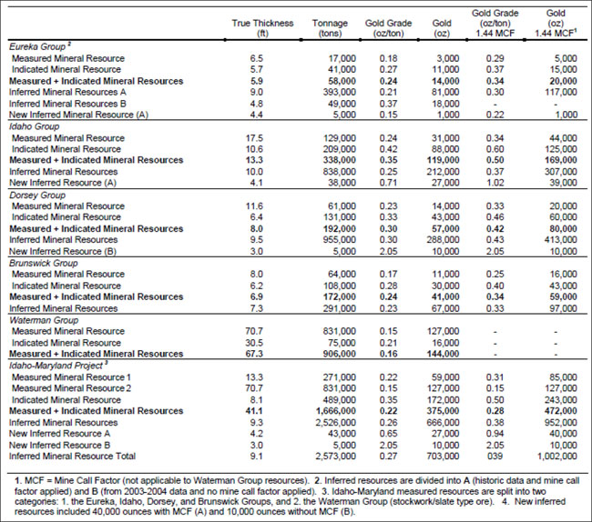
| Project No.: 194594 | Page 6-15 | |
| | Technical Report on the Idaho-Maryland Project Grass Valley California, USA |
Table 6-2: Key Parameters and Assumptions (from Pease, 2009)
| Item | Parameter/Assumption |
| Reporting Guidelines | Restated 2004 Estimate: Based on definitions outlined in the August 20, 2000 CIM Definition Standards, and 2001 version of NI 43-101. |
| 2007 Additional Estimate: Based on definitions outlined in the December 11, 2005 CIM Definition Standards, and 2005 version of NI 43-101. | |
| Data | Underground development channel samples, core drill intercepts. |
| Geological interpretation | Horizontal vein continuity range: 150–1,690ft (45.7–515m), averaging 885ft (269.7m). Vertical vein continuity range: 100–2,700ft (30.5–823m), averaging 615ft (187.4m). |
| Minimum thickness | 3ft (0.9m) true thickness for all resource blocks |
| Cutoff grade | 0.1 troy oz Au/ton (approximately 3 g/t Au) |
| Density | Tonnage factor: 12 |
| Mine Call Factor | Two factors calculated: a “model” (underground sampling) to “mine” (muck car sampling) factor, equal to 1.21, and a “mine” to “mill” factor, calculated to be 1.19. The total Mine Call Factor was equal to 1.44. |
| Estimation Methodology | Veins modelled using longitudinal sections; 2004 3-D geologic models interpolated using MineSight; 2007 3-D geologic models interpolated using Vulcan. |
| Confidence Classifications | Measured: supported only in areas exposed by underground development and estimated from detailed underground sampling. Typically projected to a maximum of 50ft (15m) along the plunge or rake direction of the mineralized zone. |
| Indicated: Material surrounding Measured Mineral Resources around underground openings and drill intercepts within resource blocks that contain multiple drill holes and evidence of the hosting vein or structure in a nearby underground working within 200ft (61m); however, the geological projection was only to 100ft (30m). Includes mineralization that would otherwise be classified as Measured but due to grade uncertainty because of numerous discontinuous pods of >1 oz/ton Au samples that had been previously capped at that value and where the true assay value was unknown, was downgraded. | |
| Inferred: Mineralization around drill intercepts projected for 100ft (30m) along strike or a maximum of 200ft (61m) up or down the plunge or rake. Where mineralization was around underground working, the projection was restricted to a maximum of 200ft (61m) from the working. |
| Project No.: 194594 | Page 6-16 | |
| | Technical Report on the Idaho-Maryland Project Grass Valley California, USA |
| 6.4 | Production History |
Rise has completed a compilation of the mine production data of the Idaho-Maryland Mine during historic operation from 1866 through 1955, the final year of production from the mine. The Company estimates that the I-M Mine produced a total of 2,414,000 oz of gold from 5,298,000 tons of mill feed and that the life of mine average mill head-grade averaged approximately 0.50oz/ton (17.1gpt). Total production for the Idaho-Maryland Mine is detailed in Table 6-3.
Table 6-3: Total Idaho-Maryland Mine Production from 1866-1955*
| Mined & Milled | Mill Head Grade | Metallurgical Recovery | Yield | Gold Produced | ||||||||||||||||
| tons | tonnes | oz/ton | gpt | % | oz/ton | oz | ||||||||||||||
| Idaho Mine | ||||||||||||||||||||
| #1 Vein | 978,000 | 887,000 | 1.12 | 38.6 | 85% | 0.96 | 935,000 | |||||||||||||
| 3 Vein system | 1,215,000 | 1,102,000 | 0.60 | 20.4 | 95% | 0.56 | 686,000 | |||||||||||||
| Total | 2,193,000 | 1,989,000 | 0.83 | 28.4 | 89% | 0.74 | 1,621,000 | |||||||||||||
| Brunswick Mine | ||||||||||||||||||||
| Old Brunswick | 41,000 | 37,000 | 0.56 | 19.3 | 85% | 0.49 | 20,000 | |||||||||||||
| Union Hill | 35,000 | 32,000 | 1.21 | 41.5 | 85% | 1.03 | 36,000 | |||||||||||||
| New Brunswick | 3,029,000 | 2,748,000 | 0.26 | 8.8 | 95% | 0.24 | 737,000 | |||||||||||||
| Total | 3,105,000 | 2,817,000 | 0.27 | 9.3 | 94% | 0.26 | 793,000 | |||||||||||||
| Total I-M Mine | 5,298,000 | 4,806,000 | 0.50 | 17.1 | 91% | 0.46 | 2,414,000 | |||||||||||||
| * | Details regarding data verification are presented in Section 6.4.4. |
In 1926, Errol MacBoyle took over management of the I-M Mine and, as President and General Manager, led the mine into its most successful period of production. A graph of production from the Idaho and Brunswick Mines from 1926 to 1955 is displayed in Figure 6-2. The historic mine workings of the Idaho-Maryland Mine are displayed in Figure 6-3.
| Project No.: 194594 | Page 6-17 | |
| | Technical Report on the Idaho-Maryland Project Grass Valley California, USA |
Figure 6-2: I-M Mine Gold Production from 1926-1955*
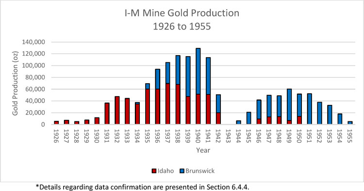
| Project No.: 194594 | Page 6-18 | |
| | |
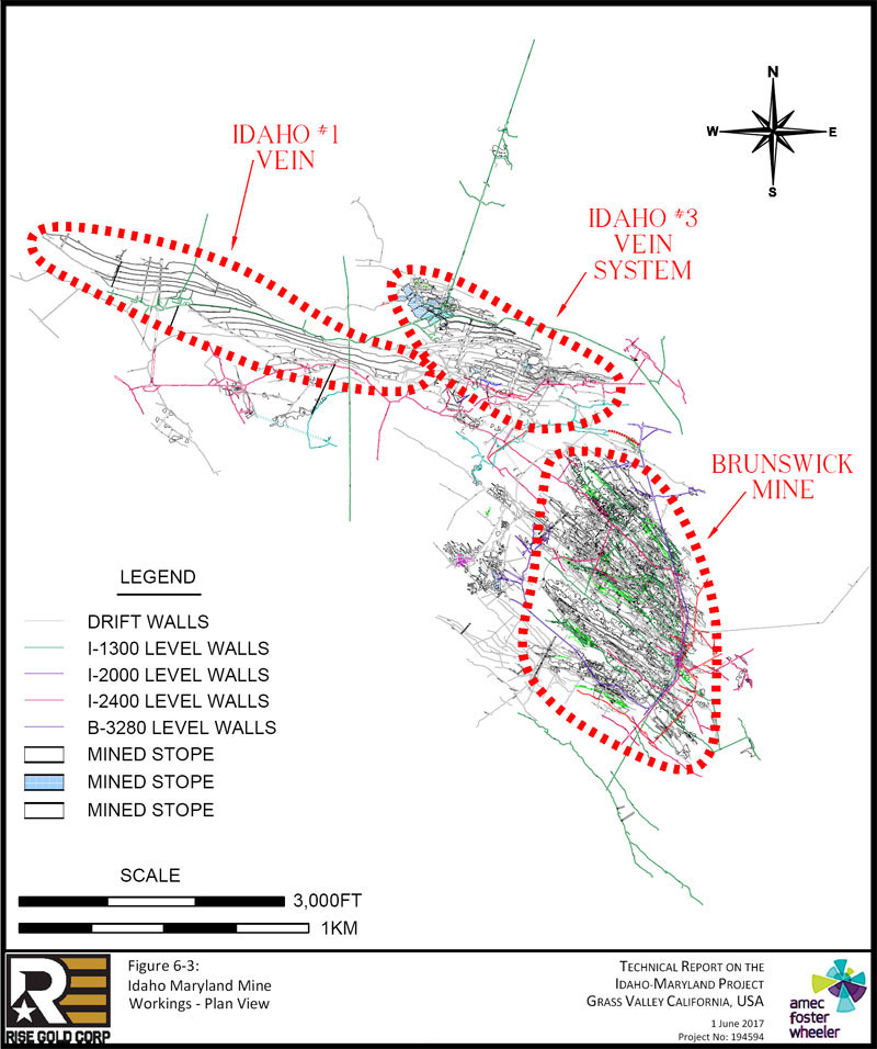
| Page 6-19 |
| | Technical Report on the Idaho-Maryland Project Grass Valley California, USA |
| 6.4.1 | Idaho Mine |
The Company estimates that the Idaho Mine produced 1,621,000oz of gold from 2,193,000 tons with an estimated average head grade of 0.83oz/ton (28.4gpt), as detailed in Table 6-3. A single continuous vein, termed the #1 Vein, was mined from 1866-1901. The #1 Vein is estimated to have produced 935,000oz of gold from 978,000 tons with an estimated average head grade of 1.12oz/ton (38.6gpt).
In 1929, Errol MacBoyle discovered the 3 Vein system which was the catalyst for a dramatic surge in production from 6,000oz gold per year in 1926 to 129,000oz per year by 1940. The 3 Vein system is similar in nature to the #1 Vein but is offset from the #1 Vein.
The #3 Vein and its splays were mined from 1929-1942. Limited mining was completed on the #3 Vein from 1946-1955 due to the loss of access to this area after the war time shutdown. The 3 Vein system is estimated to have produced 686,000oz of gold from 1,215,000 tons with an average head grade of 0.60oz/ton (20.4gpt).
Metallurgical recovery from the 3 Vein System was higher than that of the #1 Vein due to the more sophisticated machinery and processing methods used in the era in which it was mined and processed.
| 6.4.2 | Brunswick Mine |
The Company estimates that the Brunswick Mine produced 793,000oz of gold from 3,105,000 tons at an estimated average head grade of 0.27oz/ton (9.3gpt), as detailed in Table 6-3.
Errol MacBoyle acquired the Brunswick Mine in 1933 and very quickly made many new discoveries in the mine. By 1940, production from thirteen major veins at Brunswick exceeded that of the Idaho Mine with production of 78,000oz of gold per year at an estimated mill head grade of 0.28oz/ton (9.6gpt).
Brunswick Mine production includes minor production from the Old Brunswick Mine and the adjacent Union Hill Mine, both of which operated before 1918.
| Project No.: 194594 | Page 6-20 | |
| | Technical Report on the Idaho-Maryland Project Grass Valley California, USA |
| 6.4.3 | Mill Head Grade |
The mill head grade is the grade of the mineralized material which is fed into the processing plant to be concentrated into gold bullion. The mill head grade includes mining dilution from un-mineralized rock adjacent to the veins. The mill head grade does not account for metallurgical recovery of gold during the processing of the mineralized material.
| 6.4.4 | Data Verification |
Detailed production information from the internal records of the Idaho-Maryland Mine are available for the period from 1926 through 1955. Whenever possible, mill reports were reconciled against financial statements and submissions by the Company to the US Bureau of Mines. Where reconciliation between documents was possible, only minor variations in production reporting were noted. In general, the Idaho Maryland Mines Co. appears to have been a well-run company with excellent record keeping. The entire library of documents is no longer fully complete but there is sufficient material to make an accurate estimate of historic production during this period. The following materials were used to prepare an estimate during the period from 1926-1955:
| ● | Idaho Maryland Mines Co. Financial Statements (1926-1932,1934-1942). |
| ● | Idaho Maryland Mines Co. Mill Reports (1933-1942, 1946-1950). |
| ● | Idaho Maryland Mines Co. Final Distributions Sheets (1944,1945). |
| ● | Idaho Maryland Mines Co. Breakdown of Income and Expenses (1946-1949). |
| ● | Idaho Maryland Mines Co. Cost Data & Cost Sheets from (1946-1949). |
| ● | Idaho Maryland Mines Corp. Lode Mine Production Report to US Bureau of Mines (1944-1945,1947-1948,1950,1952,1953,1955). |
For the period prior to 1926 there were no internal corporate records regarding historic production. The qualified person believes this information is reliable but the source documents used by the authors of these documents are not available for reconciliation. The following documents were used to prepare an estimate during the period from 1866-1925:
| ● | Lindgren, Waldemar. The Gold Quartz Veins of Nevada City and Grass Valley Districts, California (1896). |
| ● | Hamilton, Fletcher. Mines and Mineral Resources of Nevada County (1918). |
| ● | Clark, Jack. Gold in Quartz: The Legendary Idaho Maryland Mine (2005). |
| Project No.: 194594 | Page 6-21 | |
| | Technical Report on the Idaho-Maryland Project Grass Valley California, USA |
Detailed records of metallurgical recoveries from the I-M Mine prior to 1924 are not available. From 1924-1930 gold recoveries ranged from 72% to 89% using a similar process to that used in the years prior to 1924. Lindgren (1896) estimated that gold mills in the Grass Valley mines averaged 75% metallurgical gold recovery but noted that the I-M Mine was unique in that it treated the tailings from its concentrates by secondary processes. The Company has assumed a metallurgical recovery of 85% for the pre-1924 processing at the I-M Mine which it believes is the best estimate possible given the information available.
| 6.5 | Historic Metallurgical Data |
In the period from 1936 to 1941, the I-M Mine was in full production and processed through two identical process plants located at the two mining operations within the I-M Mine Property, the Brunswick Mine and the Idaho Mine. Gold recovery from the I-M Mine is reported in detail from the processing of large amounts of mineralized material.
The Idaho mineralization had higher gravity gold recovery of 76% versus Brunswick at 64%. The average flotation concentrate grade for Idaho Mine and Brunswick Mine was 3.6 oz/ton (123gpt) and 4.2oz/ton (144gpt), respectively. Nearly all gold at the I-M Mine is free milling, as demonstrated by the leaching of flotation concentrates and tailings by the Mine during past production.
Total gold recovery from the processing of 2,011,000 tons of mineralized material from 1936 to 1941 is estimated at 96.3%, of which 67.5% is estimated to have been recovered by gravity methods. Gold recovery details for the I-M Mine is summarized in Table 6-4.
Table 6-4: Gold Recovery Summary from 1936-1941*
| Mined & Milled | Gold Produced | Mill Head Grade** | Gold Recovery | |||||||||||||||||||
| Tails | ||||||||||||||||||||||
| tons | tonnes | oz | oz/ton | gpt | Gravity | Flotation | Leach | Total | ||||||||||||||
| Idaho | 632,000 | 573,000 | 348,000 | 0.57 | 19.4 | 74.0% | 21.2% | 2.2% | 97.4% | |||||||||||||
| Brunswick | 1,379,000 | 1,251,000 | 327,000 | 0.25 | 8.5 | 60.8% | 34.3% | 0.1% | 95.2% | |||||||||||||
| Total | 2,011,000 | 1,824,000 | 675,000 | 0.35 | 11.9 | 67.5% | 27.6% | 1.2% | 96.3% | |||||||||||||
| * | Details regarding data verification are presented in Section 6.5. 2 of this Report. ** Mill Head Grade is discussed in Section 6.4.3 of this Report. |
| Project No.: 194594 | Page 6-22 | |
| | Technical Report on the Idaho-Maryland Project Grass Valley California, USA |
| 6.5.1 | Process Plant |
The process plant at the I-M Mine used the following generalized flowsheet during the period 1936 to 1941:
| 1. | Ore crushed to -5/8”. |
| 2. | Grinding using ball mills. |
| 3. | Grinding circuit classification with Dorr Classifiers. |
| 4. | Undersize from classifier sent to flotation. |
| 5. | Oversize from classify to Deister Tables. |
| 6. | Deister Tables to separate gravity gold. |
| 7. | Table concentrates sent to amalgamation or cyanide plant. |
| 8. | Flotation of classifier undersize. |
| 9. | Flotation concentrate to cyanide plant. |
| 10. | Leaching of sand fraction of tails in Idaho plant only. |
| 6.5.2 | Data Verification |
Detailed production, processing, and metallurgical data is available from the internal records of the Idaho Maryland Mine are available for the period from 1936-1941. Internal mill reports were completed by the operator on daily, monthly and yearly reports. Metallurgical data was reconciled by the operator to bullion sales. The metallurgical data from the internal documents was transcribed from the monthly reports and reconciled to the annual reports. In general, the Idaho Maryland Mines Co. appears to have been a well-run company with excellent record keeping. It is believed the entire record of mill reports is contained in the library of documents. The I-M Mine’s historical financial statements, which recorded the results from bullion sales, appear to reconcile with the historical production and the reported metallurgical recovery rates included in the historical data that the Company has reviewed. The following was used to prepare an estimate during the period from 1936-1941:
| ● | Idaho Maryland Mines Co. Mill Reports (1936-1941) |
Detailed records of metallurgical recoveries from the I-M Mine prior to 1924 are not available. From 1924-1930 gold recoveries ranged from 72% to 89% using a similar process to that used in the years prior to 1924. Lindgren (1896) estimated that gold mills in the Grass Valley mines averaged 75% metallurgical gold recovery but noted that the I-M Mine was unique in that it treated the tailings from its concentrates by secondary processes. The Company has assumed
| Project No.: 194594 | Page 6-23 | |
| | Technical Report on the Idaho-Maryland Project Grass Valley California, USA |
a metallurgical recovery of 85% for the pre-1924 processing at the I-M Mine which it believes is the best estimate possible given the information available.
| 6.6 | History of Environmental Studies and Social / Community Impacts |
A renewed interest in the idle Idaho-Maryland Mine Project was sparked by Emgold in 1990. Over the period from 1991 through 2013, Emgold completed numerous environmental studies and engaged in public consultation during the Environmental Impact Review (EIR) process for the I-M Project. A preliminary review of the environmental studies and social and community impacts by the previous operator is presented in the following section. Mine development, including exploration, by historic operators has been outlined in chronological order in Section 6.1 of this Report.
Rise is focused on mineral exploration at the Idaho-Maryland Mine and is not contemplating the permitting or re-opening of the I-M Mine at this time.
| 6.6.1 | Environmental Studies |
Numerous environmental studies have been completed on the Idaho-Maryland Mine Project by the previous operator, Emgold, from the period 1991 to 2011.
In 1996 Emgold acquired a Use Permit (Conditional Use Permit No. UP94-17) from Nevada County to dewater the I-M Mine and re-access the mine workings for the purpose of underground exploration. A National Pollutant Discharge Elimination System (NPDES) discharge permit from the California Regional Water Control Board (NPDES Permit No. 96-098) was also granted which allowed discharge of mine water into South Fork (SF) Wolf Creek. Emgold never utilized these permits and allowed them to expire without commencing any work in dewatering the mine (AMEC, 2004).
In 2003 Emgold initiated a permitting process with the City of Grass Valley for the construction and operation of a significant ceramic tile manufacturing factory, a 2400 ton per day underground room and pillar mining meta-andesite rock (Porphyrite), and the exploration and mining of gold mineralization at the I-M Mine (Pease, 2009). Emgold prepared numerous technical and environmental studies and submitted a Project Application for the I-M Project to the City of Grass Valley in 2005 with a subsequent Revised Project Application submitted in 2007. Following acceptance of the 2007 Revised Project Application, a Draft Environmental
| Project No.: 194594 | Page 6-24 | |
| | Technical Report on the Idaho-Maryland Project Grass Valley California, USA |
Impact Report (EIR) was prepared by the City of Grass Valley in 2008. Emgold made several improvements to the I-M Project based on the 2008 EIR and public comments and submitted a Revised Project Application in 2011. The 2011 Revised Project Application was not processed by the City of Grass Valley as Emgold did not have sufficient funds to pay for the review of the document and subsequent EIR. The City of Grass Valley cancelled the permit application on September 2012 after the deadline for Emgold to submit the required funds for review expired.
| 6.6.2 | Social and Community Impacts |
The 2008 Draft EIR noted the following overarching themes in written and oral comments from the public which would be important to consider in any future designs to re-access the I-M Mine (ESA, 2008).
| 1) | Air Quality – NOx gases |
| 2) | Potential impact to health and air quality from construction and operations. |
| 3) | Potential impacts related to transport, use, and disposal of hazardous materials |
| 4) | Potential impacts to water quality and ground water supply in the project area. |
| 5) | Potential impacts to biological resources including wetlands, Wolf Creek, and South Fork Wolf Creek as associated habitat and species. |
| 6) | Potential impacts caused by noise and vibration to nearby residences and business. |
| 7) | Potential impacts to traffic by increased population and operations. |
Based on a review of the 2008 Draft EIR and 2011 Revised Project Application the following issues are highlighted:
| 1) | Air Quality – NOx gases |
The Emgold project included a significant ceramic tile manufacturing factory which used a large amount of natural gas to convert the mined rock into tiles. The large use of natural gas for energy resulted in air quality concerns, primarily due to the release of NOx gases from the combustion of natural gas. The environmental effect to air quality was found to be significant and unavoidable (ESA, 2008).
Rise does not believe that the construction of a tile manufacturing plant would be proposed in the future. Impacts to air quality from the underground mining and other aspects of the proposed projects were regarded as not significant or mitigated in the technical documentation from 2008 (AMEC, 2008).
| Project No.: 194594 | Page 6-25 | |
| | Technical Report on the Idaho-Maryland Project Grass Valley California, USA |
| 2) | Mine Dewatering |
There were concerns from property owners located in the project area that the dewatering of the mine would result in the loss or degradation of their water supply from their wells. The 2008 Draft EIR considered 18 out of 78 domestic water wells in the project area to be highly exposed to potential dewatering effects due to their proximity to the mine workings. The remaining 60 wells are more distant, over 710ft (216m) away, and were considered not to be directly exposed and therefore of a lessor risk category. Emgold proposed in the 2008 EIR that it would finance and arrange for water delivery to residents in the high-risk category (18 wells) from the Nevada Irrigation District (ESA, 2008). In the subsequent 2011 Revised Application, Emgold revised its plans for Nevada Irrigation District water service from an “as needed” basis to the installation of potable water trunk and feeder line to extend the Nevada Irrigation District service to all residences that could potentially be impacted by mine dewatering and did not have an existing water service (IMMC, 2011).
| 3) | Mine Water Discharge |
In the 2008 Draft EIR, Emgold proposed to use the SF Wolf Creek as the discharge point for the treated ground water pumped from the underground mine. There were significant concerns about the discharge of water into SF Wolf Creek due to erosion, sediment re-suspension, and flooding (ESA, 2008). In the 2011 Revised Application, Emgold proposed to install a pipeline under E. Bennett Road to transfer water to the Idaho Property to discharge treated ground water from the mine into main Wolf Creek. The main Wolf Creek is significantly larger than the SF Wolf Creek (IMMC, 2011).
| 4) | Traffic |
In the 2011 Revised Application subsequent to the EIR, Emgold proposed numerous changes to its traffic routes and schedules to address concerns about traffic. These changes included the avoidance of E. Bennett Road and an elementary school on E. Bennett Road. Emgold also proposed a revised traffic management plan in order to reduce employee and visitor related trips to the mine. These changes included employee vans and incentives for employees to car pool and use bus, bikes, or pedestrian transportation to the work site. Emgold also proposed changing its workforce schedule from 8 hour shifts to 12 hour shifts to further reduce traffic trips (IMMC, 2011).
| Project No.: 194594 | Page 6-26 | |
| | Technical Report on the Idaho-Maryland Project Grass Valley California, USA |
| 7.0 | GEOLOGICAL SETTING AND MINERALIZATION |
The following discussion is summarized and in some cases taken directly from the work of several authors including Lindgren (1894), Tolman (1936), Sohlberg (1936), Johnston (1940), Bateman(1948), Hulin (1951), Berger (1968), Koschmann (1968), Ash (1996), Groves (1998), Ash (2001), Wilkerson and David Lawler (2008), Sillitoe (2008), Taylor (2015).
| 7.1 | Regional Geology |
The Idaho-Maryland project is located in the Grass Valley area of the Western Sierra Nevada Foothills of Northern California. This belt of rocks consists of late Paleozoic marine sedimentary and ophiolitic rocks, and early and late Mesozoic submarine volcanic-arc and basinal terranes.
During the middle Paleozoic Antler orogeny Neoproterozoic to middle Paleozoic deep-water passive margin sedimentary rocks were thrust onto the North American craton. Island-arc terranes were accreted to the craton margin during the Permian-Triassic Sonoma orogeny. Oblique convergence during the Late Jurassic through Early Cretaceous along the continental margin led to widespread folding, thrusting, and sinistral slip.
Plutonism within the Sierra Nevada is concentrated mainly between 170 to 140 Ma and 120 to 80 Ma. The older episode formed a semicontinuous volcanic-plutonic arc that spanned the formerly contiguous Sierra Nevada and Klamath Mountains. The younger episode, with peak magmatic activity between 100 and 85 Ma, was a major contributor to formation of the Sierra Nevada batholith.
The Western Sierra Nevada Foothills can be grouped in five major geologic terranes and complexes:
| ● | Northern Sierra terrane - the Shoo Fly Complex and an overlying Paleozoic succession of arc volcanics. |
| ● | Feather River terrane - predominantly serpentinized ultramafics containing tectonic blocks of amphibolite, plagiogranite, and mafic schists. |
| ● | Calaveras Complex – Permian-Triassic mélange comprising psuedostratigraphic sequences of both chert and argillite with incorporated blocks of limestone, amphibolite, greenschist, phyllite, and basalt. |
| Project No.: 194594 | Page 7-1 | |
| | Technical Report on the Idaho-Maryland Project Grass Valley California, USA |
| ● | Jura-Triassic arc belt - Paleozoic basement of disrupted ophiolite, serpentinite mélange, and ultramafic rocks overlain by uppermost Triassic–Early Jurassic arc volcanic and coeval 200 Ma intrusive rocks. |
| ● | Middle–Late Jurassic arc sequence - volcanic arc rocks, greenstones, and metasedimentary rocks of the Mariposa Formation, and rocks of the Smartville Complex. Coeval intrusive rocks are included within this sequence because they are probably comagmatic with the arc volcanic rocks. |
The Jura-Triassic arc belt has yielded the majority of gold production in the Western Sierra Nevada Foothills. In the Grass Valley district the Jura-Triassic arc belt is bounded along its western margin by the Wolf Creek and Bear Mountain faults and on its eastern margin by the Melones fault. Gold deposits in Jura-Triassic arc belt are associated with second, third, and fourth–order faults related to these structures. Figure 7-1 is a geologic map of northern California.
Figure 7-1: Geologic Map of Northern California (from Taylor et al., 2015)
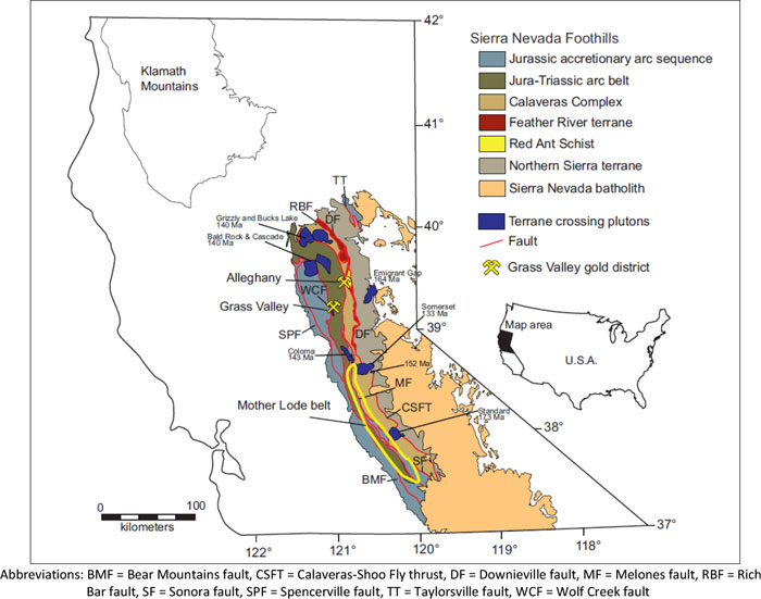
| Project No.: 194594 | Page 7-2 | |
| | Technical Report on the Idaho-Maryland Project Grass Valley California, USA |
| 7.2 | Local Geology |
The Grass Valley area is dominated by blocks of variably metamorphosed volcanic, mafic plutonic, and minor sedimentary rocks that range from 0.1 m to nearly 2.5 × 1 km in size hosted in a serpentinite matrix. The whole package of rocks exhibits a region foliation and is interpreted as a serpentinite-matrix tectonic mélange formed during subduction and accretion of the Jura-Triassic Lake Combie complex island arc rocks. These rocks were variably metamorphosed from lower greenschist to amphibolite facies during and after their accretion to the continental margin. The Late Jurassic Grass Valley granodiorite (also known as La Barr Meadows pluton) intrudes the Lake Combie complex. The pluton is elongate in the N-S direction and has an irregular shape, is approximately 8 to 9 km long and ranges from less than 1 km to more than 3 km wide. The granodiorite is a medium-grained, leucocratic intrusion. The entire pluton was variably altered by post crystallization hydrothermal activity but has not been affected by metamorphism. The Grass Valley granodiorite was emplaced within approximately 3 km of the surface. Structural characteristics of the gold-bearing quartz veins reflect ductile to brittle deformation including fragments of granodiorite indicates the pluton was solidified prior to vein formation. This suggest vein formation also in the 3km depth range.
Two distinct gold vein groups exist within the Grass Valley district: steeply dipping E-W-trending veins in the northern and generally N-S trending veins with gentler dips averaging 35° in the southern part of the district. The most important E-W veins are associated with the Idaho-Maryland project. Significant veins of the N-S vein group include those of the Empire, North Star, and W.Y.O.D. deposits.
A few kilometers to the east of the Wolf Creek fault zone, the second-order Grass Valley and Weimar faults bound serpentinite and metavolcanic rocks that hosts the E-W trending Idaho-Maryland deposit.
The N-S veins are hosted in both the arc belt meta-volcanic rocks and in the Grass Valley granodiorite intrusion. The majority of the N-S veins dip toward the intrusion and pass from the metamorphic country rocks into the granodiorite with little to no disturbance to the vein shape, trend, or dip.
Both vein sets have extraordinary vertical and lateral persistence; individual veins extend for kilometers. The generalized geology of the Grass Valley gold district is shown in Figure 7-2.
| Project No.: 194594 | Page 7-3 | |
| | Technical Report on the Idaho-Maryland Project Grass Valley California, USA |
Figure 7-2: General Geologic Map of the Grass Valley Gold District (from Taylor et al., 2015)
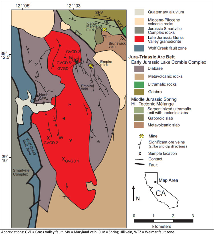
| Project No.: 194594 | Page 7-4 | |
| | Technical Report on the Idaho-Maryland Project Grass Valley California, USA |
| 7.3 | Property Geology |
The Idaho-Maryland area was described in Emgold Technical Reports in context of several tectonic blocks or slabs such as the Brunswick, Maryland, Fulton, Sealy, Alpha, Beechel, Greenhorn slabs. These slabs are considered tectonic blocks of the Combie complex and are representative of the tectonic melange characteristic of Jura-Triassic arc belt in this region. All of the significant gold production from the Idaho-Maryland Mine was localized within and around the Brunswick Block.
The Brunswick Block consists of variably metamorphosed volcanic and intrusive, and minor sedimentary rocks volcanic rocks. Lindgren originally mapped the block as an amphibolite schist in the eastern portions and “porphyrite” in the west. The term “porphyrite” was used at the time of the initial discovery of gold in the region and appears to have been applied to pre-Tertiary andesitic pyroclastics, agglomerates, and breccias, as well as meta-andesite. Lindgren interpreted the amphibolite schist as a metamorphosed equivalent of the “porphyrite”. Historic mine records appear to consider the entire package of schistose and non-schistose volcanic rocks as a Brunswick “porphyrite” block.
The Brunswick Block is surrounded to the west, north, and east by gabbro and sepentinite rocks. Tertiary volcanic rocks overlying the Combi complex mask rock units along the southern boundary of the Brunswick Block.
The contacts between the Brunswick Block and surrounding gabbro and serpentinite are dominated by the 6-3, the Idaho, and the Morehouse fault domains. Mineralization is closely associated with these significant structures.
The geology of the Idaho-Maryland mine area is shown in Figure 7-3.
| Project No.: 194594 | Page 7-5 | |
| | |
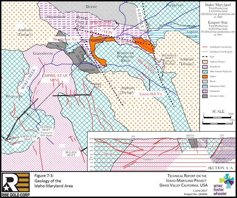
| Page 7-6 |
| | Technical Report on the Idaho-Maryland Project Grass Valley California, USA |
| 7.3.1 | Idaho Fault Zone |
The Idaho Fault Zone lies along the northern boundary of the Brunswick Block as a continuous fault system and is a major control of the Idaho-Maryland gold mineralization. The fault zone is poorly exposed on surface but is intersected in much of the underground workings. The zone strikes 275° to 290° and dips 60° to 70° south, possibly shallowing with depth, and is interpreted to have reverse movement. The Idaho fault zone is traceable underground for 3 km along strike and is shown on mine level plans down to I2700 level, a vertical depth of 3,000ft (914m) . At the western end it is a single fault on the footwall of a diabase dike separating the Brunswick Block from gabbro and sepentinite to the north. In the eastern area of the mine the Fault splits into several main, and minor branches. The fault in the eastern area is also associated with a diabase dike on the outside margin of the Brunswick Block and is comprised of both linear and nonlinear fault members. The non-linear faults are sigmoidal link faults that trend north-easterly, dipping 20° to 40° SE.
The Idaho fault zone is generally associated with the diabase dikes within the sepentinite but fault splays are known to intersect the Brunswick Block. Post-mineral reactivation of the faults reportedly show 15 m of normal displacement in some cases.
| 7.3.2 | 6-3 Fault Zone |
The 6-3 Fault forms the eastern termination of the Brunswick Block and is a major control on the gold mineralization hosted within the Brunswick Block. The 6-3 Fault is poorly exposed on surface but is intersected in many underground workings and drill holes. The fault strikes 330° to 350°, dipping 70° NE and is interpreted as a reverse fault. No significant gold mineralization is noted within or east of the 6-3 Fault.
| 7.3.3 | The Morehouse Fault |
The Morehouse Fault lies on the southwestern margin of the Brunswick Block and is a control on mineralization. It has been intersected in underground workings and drilling but is not well exposed on surface. Underground it is represented by several fault intersections and veins, such as the Morehouse, 16, and 52 Veins, that suggest it strikes northwesterly and dips around 40 degrees NE. Slickensides and mullions suggest reverse movement. The relationship between the Morehouse and Idaho fault systems is unclear. The Morehouse fault may splay into to the Idaho Fault in a northwesterly direction or may follow the westerly nose of the Brunswick Block in an arc to merge into the E-W trending Idaho fault. The easterly trend and orientation of the
| Project No.: 194594 | Page 7-7 | |
| | Technical Report on the Idaho-Maryland Project Grass Valley California, USA |
Morehouse fault is not well known due to limited drilling and underground development on the southern side of the Brunswick Block, and due to the poor surface expression of these faults. Bateman has suggested the Morehouse structure may continue easterly to the 6-3 Fault and to depth until it intersects the Idaho fault.
Figure 7-4 shows the generalized faults and veins of the Idaho-Maryland area.
| Project No.: 194594 | Page 7-8 | |
| | |
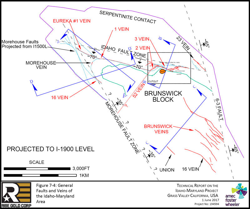
| Page 7-9 |
| | Technical Report on the Idaho-Maryland Project Grass Valley California, USA |
| 7.4 | Mineralization |
The gold-bearing quartz veins strike in all directions, and range from horizontal to vertical. Gold is hosted in discrete veins and in stockworks consisting primarily of massive to banded, sheared, and brecciated milky white quartz ± carbonate. Gold occurs as native gold, ranging from very fine grains to large nuggets within the quartz. Sulfide minerals from 1% to 4% are commonly associated with gold mineralization. Sulphides are primarily pyrite with lesser galena, chalcopyrite. Pyrite is the dominant accessory mineral and constitutes up to 2% of the vein mineralization. Sphalerite and arsenopyrite are rarely observed. Scheelite is common in the Union Hill area of the Brunswick veins. Gangue minerals include quartz, carbonate (ankerite, calcite, dolomite, and ferrodolomite), sericite, chlorite, mariposite, and albite. Ankerite is a common alteration mineral and may occur in the mafic and ultra-mafic rocks and the meta-volcanic rocks. The mineralized wallrock is strongly carbonate altered.
The meta-volcanic and meta-sedimentary rocks of the Brunswick Block are brittle rocks that fracture readily; the footwall serpentine does not readily sustain fractures.
Mineralized diabase dikes and slabs have produced a minor part of the gold mined from the Idaho-Maryland deposit. Although this style of mineralization appears to be quite prevalent throughout the mine it has a significantly lower average gold content in comparison to the gold quartz veins. This style of mineralization has potential to become more economically important in the current era due to the lower cut-off grades in relation to those employed during the time period of which the I-M was in production.
Gold mineralization at the Idaho-Maryland deposit can be divided into three significant vein systems; the Idaho-Maryland, the Brunswick, and the Morehouse.
| 7.4.1 | Idaho Vein System |
The #1 Vein, #2 Vein, and 3 Vein System comprise the Idaho Vein System.
| 7.4.1.1 | Idaho #1 Vein |
The Eureka discovery showing outcropped at the western end of the #1 Vein system but had only minor gold concentration and could not be trace on surface east or west. High grade mineralization plunging to the south east was intersected starting at approximately 100 ft (30 m) below surface at this showing. Follow-up exploration and mining led to the development of the prolific Eureka-Idaho ore shoot which plunges at approximately 30° to the south east and
| Project No.: 194594 | Page 7-10 | |
| | Technical Report on the Idaho-Maryland Project Grass Valley California, USA |
has a pitch length of almost 1 mile (1.6km) and a breadth of 500ft to 1,000ft (152m to 305m). The width of the vein within the ore shoot averaged approximately 3ft (~1m) and in places ranged up to 8ft (~2.4m). The average insitu grade of the #1 Vein would likely been slightly higher than the estimated mill head grade of 1.12oz/ton (39gpt). The extents of the Eureka-Idaho ore shoot are shown in Figure 7-5. The trend of the shoot is approximately parallel to an expect trend of the intersection of the Idaho and Morehouse faults suggesting the interaction of the Idaho and Morehouse faults may have played a role on the formation of the rich mineralization encountered in the Eureka-Idaho stope. Alternatively, the shape of the Brunswick Block may have influenced this trend.
| Project No.: 194594 | Page 7-11 | |
| | |
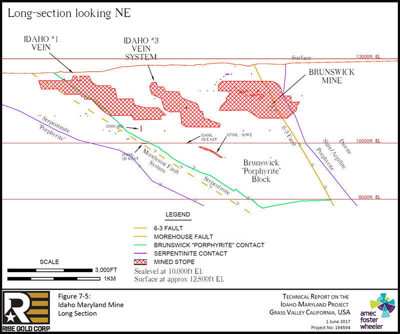
| Page 7-12 |
| | Technical Report on the Idaho-Maryland Project Grass Valley California, USA |
The Idaho #1 Vein occurs coincident with a diabase dike hosted in sepentinite in close proximity to the sepentinite-Brunswick Block contact. Just west of the Idaho shaft at the western end of the Idaho #1 Vein the diabase dike bends in an arc to the south mimicking a fold around the nose of the Brunswick Block. The Eureka-Idaho ore shoot pinches out at the I1500 Level but significant gold grades coincident with a diabase dike hosted in sepentinite in closed proximity to the Serpentinite-Brunswick contact were exposed in workings on the I2400 Level suggesting the vein may open up again or a second vein is present. To the east, the Eureka-Idaho ore shoot pinches out near the #2 Vein. All rocks are highly altered and contain much ankerite. The cross section in Figure 7-6 shows the general form and relationship of the #1 Vein with the sepentinite and diabase dike. The cross section in Figure 7-7 shows the extent of stoping and the relation of the vein to the serpentinite and Brunswick Block contact.
Figure 7-6: #1 Vein Cross Section, Section looking East (Lindgren, 1896)
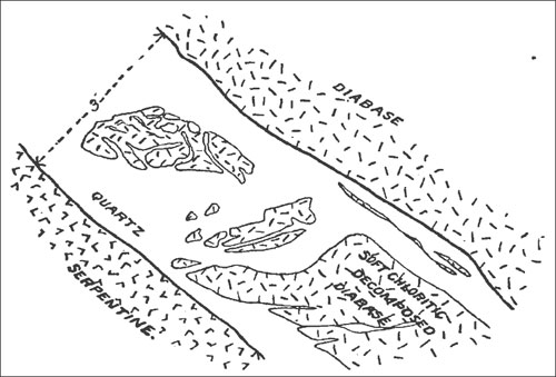
| Project No.: 194594 | Page 7-13 | |
| | |
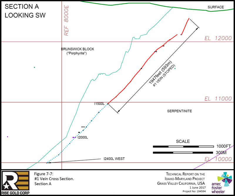
| Page 7-14 |
| | Technical Report on the Idaho-Maryland Project Grass Valley California, USA |
| 7.4.1.2 | Idaho #2 Vein |
The #2 Vein is a disrupted zone of quartz veins trending northeast and dipping steeply to the south east. This vein system is hosted in the sepentinite approximately coincident with where the serpentinite-Brunswick Block contact bends abruptly to the north before turning east again. #2 Vein trends northeast into the 3 Vein System. The #2 Vein is shown in plan view in Figure 7-8.
| 7.4.1.3 | 3 Vein System |
The 3 Vein System like the #1 Vein system hosts a prolific ore shoot. The 3 Vein System comprises an Idaho fault split into four main branches. Connecting diagonal structures between the four fault branches were also mineralized. As with the #1 Vein, gold mineralization is associated with a diabase dike sub parallel to the serpentine-Brunswick Block contact. The main 3 Vein was mined continuously over a vertical distance of approximately 1,500ft (457m) and an average horizontal strike length of approximately 700ft (213m). There were several important veins which splayed from the main 3 Vein, forming the larger 3 Vein System. The most important of which were named the 5 Vein, 13 Vein, and 22 Vein. Minor splays from the main 3 Vein included 19 Vein, 4 Vein, and 6 Vein. The 3 Vein ranged in dip from 45° to 70°, with an average dip of approximately 55°. An average vein width of approximately 5ft (1.5m) was typical but in places reached widths of over 20ft (6m).
In the 3 Vein System, the best mineralization was typically found in quartz veins where the Idaho structures intersected areas where diabase dikes or Brunswick Block rocks are in contact with the serpentinite unit. Veins hosted solely in serpentinite were rarely of economic importance due to the yielding nature of the serpentinite which typically does not allow wide or continuous open structures to form from faulting. The 23 Vein is an exception. Also known as the Rose Garden, it was intersected by exploration drifting 2,000ft (610m) east of the main 3 Vein System on I2000 Level. The mine operator was following the Idaho #5 Vein towards the 6-3 Fault and located the 23 Vein by diamond drilling. 23 Vein dips to the northwest as opposed to the southwest and is hosted entirely in serpentinite. It is quite narrow but was noted to contain abundant visible gold. The 23 Vein was followed along strike to the south east directly to its intersection with the 6-3 Fault.
The 3 Vein System is shown in plan and section view in Figure 7-8 and Figure 7-9 and the 23 Vein is shown in Figure 9-11.
| Project No.: 194594 | Page 7-15 | |
| | |

| Page 7-16 |
| | |
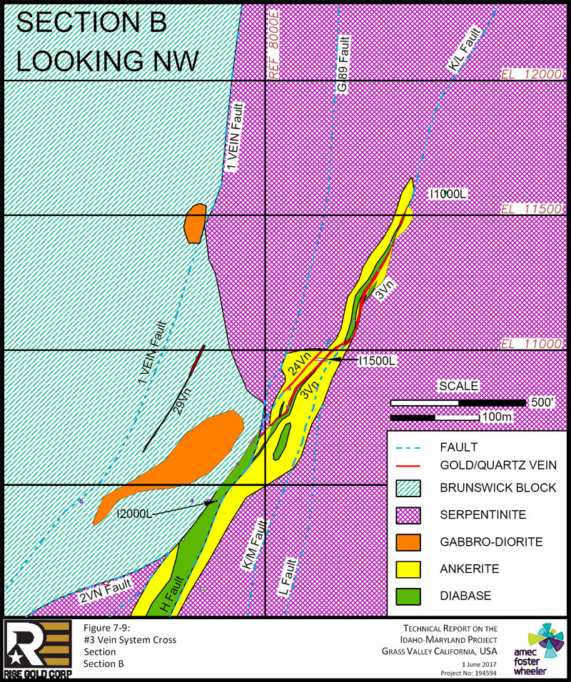
| Page 7-17 |
| | Technical Report on the Idaho-Maryland Project Grass Valley California, USA |
| 7.4.2 | Brunswick Vein System |
The Brunswick vein system constitutes a distinct vein system within meta-volcanic rocks of the Brunswick Block. The veins strike northwesterly and have a southwesterly dip. These parallel, vertically dipping mineralized veins were mined above 1600L along continuous strike lengths ranging from 430ft (131m) to 1,000ft (305m) with continuous vertical heights reaching up to 1,000ft (305m). These veins generally range from several inches up to 8ft (2.4m) in width. A few veins with opposite strike and dip occur. The veins are most numerous and have the highest grades near the 6-3 Fault. The veins nearest to the fault turn to the north on the footwall side, suggesting a northward component of movement of the hanging wall. A quartz-carbonate stockwork develops near the fault. The quartz stringers dip from the veins toward the fault and many have connecting diagonals extending from an upper to a lower stringer toward the fault. The Brunswick veins generally pinch out before rarely coming in contact with the fault footwall. No significant mineralization is present in the fault. Only a few unimportant veins are known beyond its hangingwall.
In the area of the Brunswick veins are layers of meta-sedimentary rocks within the meta-volcanic rocks that exhibit the regional N-W schistosity dipping very steeply to the north. Where the Brunswick veins cross these meta-sedimentary rocks vein splitting and en-echelon crossings occur forming what is known in the historical records as “Zebra Rock.” The “Zebra Rock” produced “fair” to “good” grades of large tonnage and the presence of free gold was reported. In the 2009 Emgold Technical Report, parts of the “Zebra Rock” were referred to as the “Waterman Zone”.
A large “Zebra Rock” zone was intersected and mined along the western extents of 16 Vein from levels 1300L to 1000L. Mining in this zone occurred over strike lengths from 360ft to 525ft (110m to 160m) and reached widths of up to 110ft (34m) on 1100 level.
| Project No.: 194594 | Page 7-18 | |
| | |
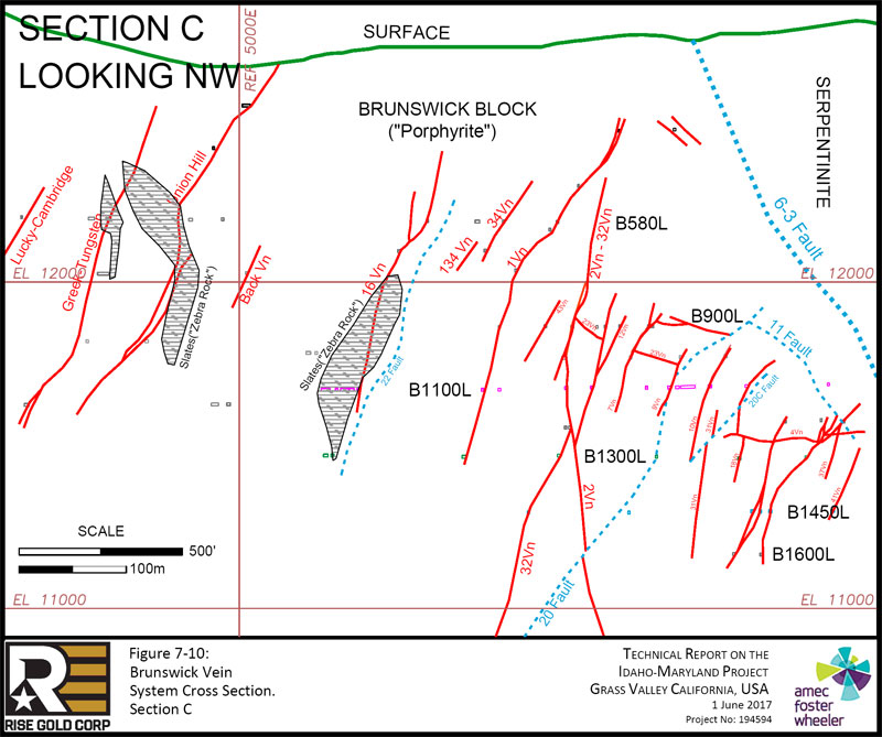
| Page 7-19 |
| | |
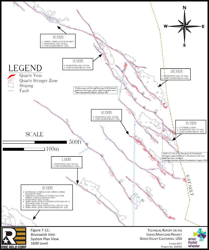
| Page 7-20 |
| | Technical Report on the Idaho-Maryland Project Grass Valley California, USA |
| 7.4.3 | Morehouse Vein System |
The Morehouse vein system is not as well understood as the Idaho #1, #2, 3 Vein System, and Brunswick vein systems. It is defined by fault and quartz-vein and quartz stockwork intersections in workings and drill holes in only a few areas such as the Morehouse, 16, and 52 Veins and 60 Winze. There is little production from this vein system.
| 7.4.3.1 | Morehouse Vein |
The Morehouse vein is associated with the serpentinite-hosted diabase dike wrapping around the western end of the Brunswick Block. Underground working show the Morehouse connects directly to the Idaho #1 Vein. The extension of the Idaho shaft in 1923 to I1500 Level intersected the Morehouse splay and the shaft station on I1500 Level is right on top of the vein.
| 7.4.3.2 | 52 Vein & 60 Winze |
The best Morehouse mineralization intersected to date and the only significant production occurs within the Brunswick Block at the 52 Vein and 60 Winze area. There is very little other exploration of this vein in the Brunswick Block. The 52 Vein and 60 Winze are shown in plan view in Figure 7-12 and in section view in Figure 7-13.
| Project No.: 194594 | Page 7-21 | |
| | |
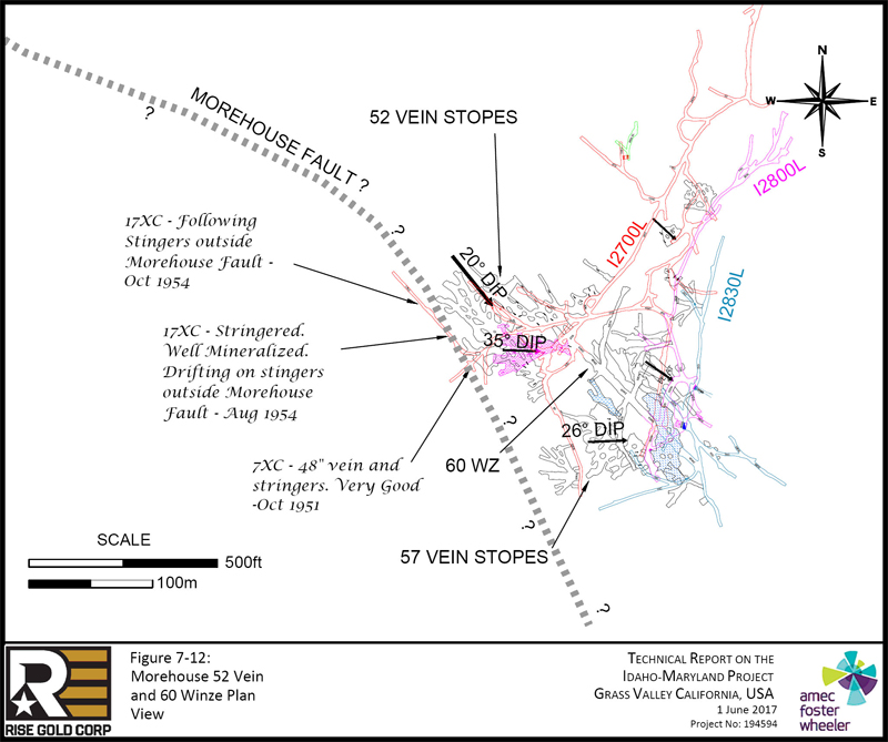
| Page 7-22 |
| | |
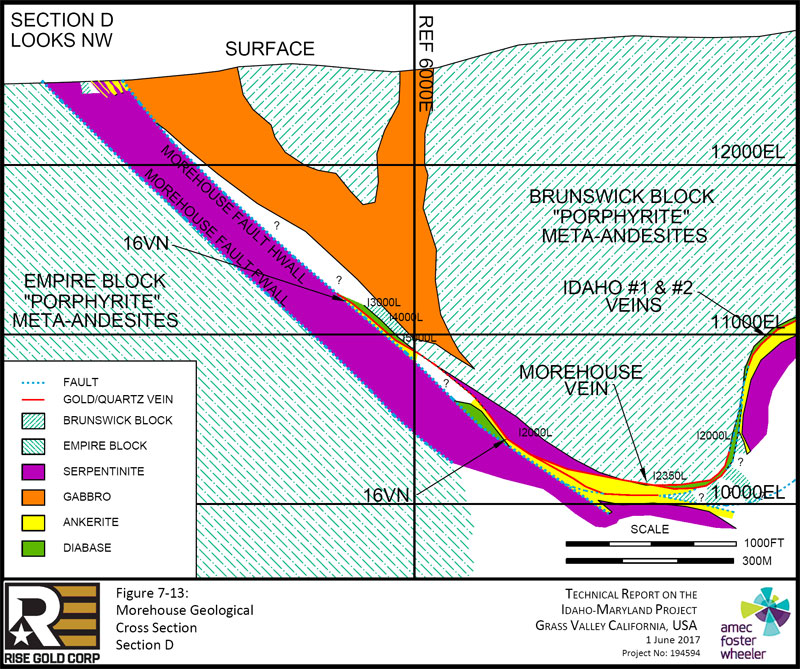
| Page 7-23 |
| | Technical Report on the Idaho-Maryland Project Grass Valley California, USA |
| 8.0 | DEPOSIT TYPES |
The Idaho-Maryland Deposit is an orogenic gold deposit. The following description of orogenic gold deposits is summarized from Groves et al. (1998). Orogenic gold deposits encompass a broad range of depth of formation and different host lithologies; however, common to orogenic gold deposits is a spatial association with compressional to transpressional deformation processes at convergent plate margins in accretionary and collisional orogens. Most ores are post-orogenic with respect to tectonism of their immediate host rocks but are simultaneously syn-orogenic with respect to ongoing deep-crustal, subduction-related thermal gradient. Depth of formation of orogenic deposits are best subdivided into epizonal (<6 km / <3.7mi), mesozonal (6–12 km / 3.7-7.5mi), and hypozonal (>12 km / >7.5mi). Figure 8-1 is a schematic representation of crustal environments of hydrothermal gold deposits in terms of depth of formation and structural setting within a convergent plate margin.
| Figure 8-1: | Schematic Representation of Crustal Environments of Hydrothermal Gold Deposits (modified from Groves et al., 1998) |
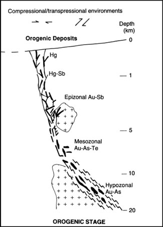
| Project No.: 194594 | Page 8-1 | |
| | Technical Report on the Idaho-Maryland Project Grass Valley California, USA |
The Grass Valley gold deposits, including the Idaho-Maryland deposit, are classified as Mesothermal Quartz Veins (Lindgren, 1894), are also known as and are type-examples of low-sulfide Au-quartz vein deposits (Berger, 1986), and gold quartz vein deposits (Ash, 2001). These classifications are sub-groups of orogenic gold deposit type.
The following description of general orogenic gold deposit characteristics is summarized from Berger (1986), Ash (1996), Groves (1998), and Ash (2001).
Geological Environment
| ● | Tectonic Setting: |
| o | Formed during deformational processes at convergent plate margins. |
| o | The majority of deposits are sited in ductile to brittle structures, and were deposited at 300 ± 50°C and 1–3 kbar. |
| o | The evidence for formation of these gold deposits over pressure-temperature (P–T) ranges of about 180–700°C and -1–5 kbar implies vertically extensive hydrothermal systems. |
| ● | Age of Mineralization: |
| o | Precambrian to Tertiary. |
| o | Mineralization is post-peak metamorphism (i.e. late syncollisional) with gold-quartz veins particularly abundant in the Late Archean and Mesozoic. North America Cordilleran gold veins are post-Middle Jurassic and appear to form immediately after accretion of oceanic terranes to the continental margin. |
| ● | Host/Associated Rock Type: |
| o | Oceanic metasediments: regionally metamorphosed volcanic rocks, graywacke, chert, shale, and quartzite. Alpine gabbro and serpentine. Late granitic batholiths. |
| o | Greenschist to amphibolite-facies rocks. |
| ● | Deposit Form: |
| o | Tabular fissure veins in more competent host lithologies, veinlets, and stringers forming stockworks in less competent lithologies. Typically occur as a system of en echelon veins on all scales. Lower grade bulk-tonnage styles of mineralization may develop in areas marginal to veins with gold associated with disseminated sulphides. May also be related to broad areas of fracturing with gold and sulphides associated with quartz veinlet networks. |
| Project No.: 194594 | Page 8-2 | |
| | Technical Report on the Idaho-Maryland Project Grass Valley California, USA |
| o | Vein systems may be continuous along a vertical extent of 1-2 km with minor change in mineralogy or gold grade; mineral zoning does occur, however, in some deposits. |
| ● | Texture/Structure: |
| o | There is strong structural control of mineralization at a variety of scales. Normally sited in second or third order structures, most commonly near large-scale, often transcrustal compressional structures. |
| o | Simple to complex networks of Au-bearing, laminated quartz-carbonate fault-fill veins localized in moderately/steeply dipping, compressional brittle-ductile shear zones and faults. |
| o | Mineralized structures have small syn- and post-mineralization displacements, but the gold deposits commonly have extensive down-plunge continuity of hundreds of metres to kilometres. Extreme pressure fluctuations leading to cyclic fault-valve behavior result in flat-lying extensional veins and mutually cross-cutting steep fault veins that characterize many deposits. |
| ● | Ore Mineralogy: |
| o | Quartz-dominant vein systems with <3–5% sulfide minerals, mainly Fe-sulfides and <5–15% carbonate minerals. |
| o | Native gold + pyrite + galena + sphalerite + chalcopyrite + arsenopyrite ± pyrhotite. Locally tellurides ± scheelite ± bismuth ± tetrahedrite ± stibnite ± molybdenite ± fluorite. Carbonates of Ca, Mg, and Fe abundant. |
| o | Gold grades are relatively high, historically having been in the 0.2-1oz/ton (5–30 g/t) range; modern-day bulk mining methods has led to exploration of lower grade targets. |
| o | Gold-bearing veins exhibit variable enrichments in As, B, Bi, Hg, Sb, Te and W; Cu, Pb and Zn concentrations are generally only slightly elevated above regional backgrounds. |
| o | Mineralization occurs in the veins and in sulfidized wallrocks. |
| ● | Gauge Mineralogy: |
| o | Quartz, carbonates (ferroan-dolomite, ankerite ferroan-magnesite, calcite, siderite), albite, mariposite (fuchsite), sericite, muscovite, chlorite, tourmaline, graphite. |
| ● | Alteration Mineralogy: |
| o | Alkali metasomatism involves sericitization or, less commonly, formation of fuchsite, biotite or K-feldspar and albitization and mafic minerals are highly chloritized. |
| o | Silicification, pyritization and potassium metasomatism generally occur adjacent to veins (usually within a metre) within broader zones of carbonate alteration, with or |
| Project No.: 194594 | Page 8-3 | |
| | Technical Report on the Idaho-Maryland Project Grass Valley California, USA |
without ferroan dolomite veinlets, extending up to tens of metres from the veins. Type of carbonate alteration reflects the ferromagnesian content of the primary host lithology; ultramafics rocks - talc, Fe-magnesite; mafic volcanic rocks - ankerite, chlorite; sediments - graphite and pyrite; felsic to intermediate intrusions - sericite, albite, calcite, siderite, pyrite. Quartz-carbonate altered rock (listwanite) and pyrite are often the most prominent alteration minerals in the wallrock. Fuchsite, sericite, tourmaline and scheelite are common where veins are associated with felsic to intermediate intrusions.
| ● | Ore Controls: |
| o | Veins are persistent along regional high-angle faults, joint sets. High-grade ore shoots locally at metasediment-serpentine contacts. Disseminated ore bodies where veins cut granitic rocks. |
| o | Gold bearing veins are more commonly economic where hosted by relatively large, competent units, such as intrusions or blocks of obducted oceanic crust. |
Associated Deposits
The relationship between epithermal veins, gold-rich porphyry, skarn, and orogenic gold deposits is shown in Figure 8-2. The epithermal veins, porphyries and skarns, as well as the sedimentary rock-hosted type Carlin ores, are emplaced in shallow regions in extensional environments. In contrast, orogenic gold deposits are emplaced during compressional to transpressional regimes and throughout much of the upper crust, in deformed accretionary belts adjacent to continental magmatic arcs.
| Project No.: 194594 | Page 8-4 | |
| | Technical Report on the Idaho-Maryland Project Grass Valley California, USA |
| Figure 8-2: | Relationship between Epithermal Veins, Gold-rich Porphyry, Skarn, and Orogenic Gold Deposits (Groves et al., 1998) |
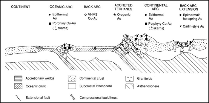
Exploration Guides
| ● | Geochemical Signature: |
| o | Arsenic best pathfinder in general; Ag, Pb, Zn, Cu. |
| o | Elevated values of Au, Ag, As, Sb, K, Li, Bi, W, Te and B ± (Cd, Cu, Pb, Zn and Hg) in rock and soil, Au in stream sediments. |
| ● | Geophysical Signature: |
| o | Faults indicated by linear magnetic anomalies. Areas of alteration indicated by negative magnetic anomalies due to destruction of magnetite as a result of carbonate alteration. |
Economic Factors
| ● | Orogenic gold deposits are locally high grade and may yield large quantities of gold. While the vein systems or structures can be relatively easy to trace, ore shoots are less predictable. Closely spaced drilling, or alternatively underground exploration, is typically required to demonstrate the existence of resources with economic potential. |
| ● | Orogenic gold deposits may be difficult to evaluate due to “nugget effect”, hence the adage, “Drill for structure, drift for grade”. |
| Project No.: 194594 | Page 8-5 | |
| | Technical Report on the Idaho-Maryland Project Grass Valley California, USA |
| ● | Veins are commonly less than 2m wide and therefore, only amenable to underground mining. |
Past production at the Idaho-Maryland Mine has demonstrated significant vertical and horizontal continuity of the veins. The great vertical extents of veins of similar gold deposits, such as the adjacent Empire Mine, suggests extensions of the #1 Vein, 3 Vein system, and the Brunswick Veins to depth and there exists potential for significant stockwork-style mineralization within the Brunswick Block.
| Project No.: 194594 | Page 8-6 | |
| | Technical Report on the Idaho-Maryland Project Grass Valley California, USA |
| 9.0 | EXPLORATION |
As of the writing of this Report, Rise has not completed an exploration work program on the Property of the Idaho-Maryland Mine. Rise compiled the extensive historical dataset into digital format and used this data to identify several promising exploration targets. Data compilation and processing completed by Rise is summarized as follows:
| ● | Scanned historical documents into a digital library. |
| ● | Reviewed available historical exploration and development data of the I-M Mine. |
| ● | Reviewed reports on the Idaho-Maryland Deposit and local geology, written by geologists and engineers employed at the Mine, hired as Consultants, or external professionals. |
| ● | Prepared a detailed 3D mine model of the mine workings (drifts, raises, and winzes) and stopes. |
| ● | Prepared a 3D geological model of vein locations, faults, rock types, and contact locations. |
| ● | Developed a historical diamond drill hole database. |
| ● | Tabulated historical production at the I-M Mine. |
Compilation of the historic data led to the identification of several exploration targets.
| 9.1 | Exploration Targets |
There are numerous exploration targets in and around the historic mine workings which will require further evaluation to determine their importance. The most significant exploration targets identified at the Idaho-Maryland Gold Project are in untested ground below the historic mine workings. These targets are the Idaho #1 Vein, Crackle Zone, Brunswick, and 3 Vein System. The general locations of the exploration target areas are shown in Figure 9-1.
| Project No.: 194594 | Page 9-1 | |
| | |
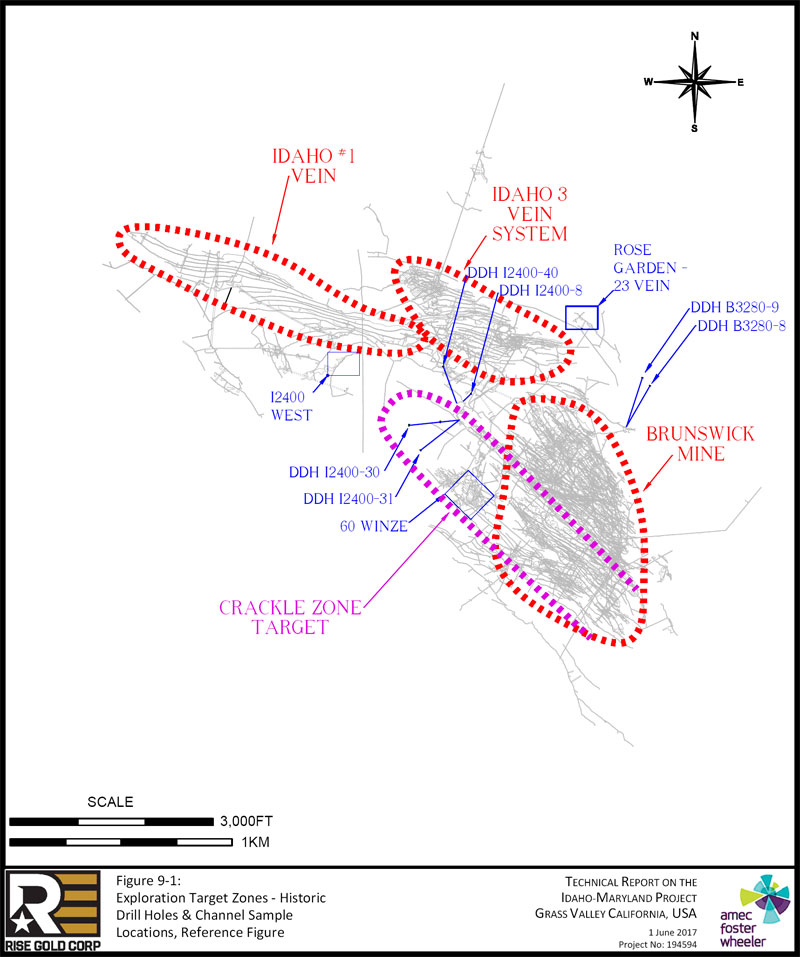
| Page 9-2 |
| | Technical Report on the Idaho-Maryland Project Grass Valley California, USA |
| 9.1.1 | Idaho #1 Vein Exploration Target |
The #1 Vein exploration target is an area below the current workings of the Idaho #1 Vein. Stoping in the prolific #1 Vein does not continue below the I1500 Level and from limited historical mapping from this area it appears that the mineralization pinched out below the I1500 Level. Very little exploration and development took place on the #1 Vein after the mine closed in 1901. In 1922, the 87 Winze was driven to the I2350 Level. Drift development on I2350 Level intersected typical diabase dike hanging wall and serpentinite footwall rock but mineralization was reported to be very narrow. The area was not further explored until 1942 when the major capital project, including sinking the new 45 Winze within the serpentinite wrapping around the nose of the Brunswick Block, was completed to the I2400 Level.
In 1942, I-M Mine completed 540ft (165m) of development in well mineralized quartz along I2400 Level West. Numerous channel samples were taken over the 540ft (165m) length. A total of 89 channel samples, taken in the quartz vein at a spacing of approximately 6ft (1.8m) show a weighted average grade of 1.58oz/ton gold (54gpt) over an average width of 1.79ft (0.5m). A total of 68 channel samples from the vein wall show a weighted average grade of 0.19oz/ton (7gpt) over an average width of 4.57ft (1.4m). The channel sample results, by historic operators, along I2400 West are tabulated in Table 9-1.
The I2400 West channel sample locations are shown in Figure 9-2. Sample lengths in the figure are in inches. Au grades are in oz/ton. Mk refers to a Muck Sample. Au written in red refers to visible gold. Sampling is assumed to be quartz vein and vein wall. Channel sample lengths are assumed to represent true width of the quartz vein but information regarding channel sampling methods used to confirm this is not available. Rise assigned a sample number starting at the southwest (lower left in Figure 9-2). Development of the I2400 West heading was halted in August 1942 due to the war time shutdown. Access to the area was lost after the war and no development recommenced in this area.
I-M Mine completed 250ft (76m) length of drifting on I2400 Level East. Development was halted in 1939 due to inability to locate the vein. Development on the east side remained idle until October 1953 when the vein was located by diamond drilling. Development of the on I2400 East Level continued until March 1954 just before the mine was closed permanently. At the time of shutdown, reports indicate that the vein and the adjacent diabase dike were “well mineralized” over a width of approximately 30ft (9m).
| Project No.: 194594 | Page 9-3 | |
| | Technical Report on the Idaho-Maryland Project Grass Valley California, USA |
| Figure 9-2: | #1 Vein Target I2400 Level West Channel Sample Locations |
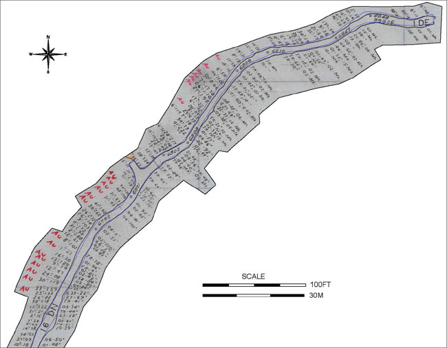
Sample lengths are in inches, Au grades are in oz/ton. Mk refers to a Muck Sample. Au written in red refers to visible gold. Sampling is assumed to be vein and vein wall.
| Project No.: 194594 | Page 9-4 | |
| | Technical Report on the Idaho-Maryland Project Grass Valley California, USA |
Table 9-1: #1 Vein Target – I2400 West Channel Sample Results
| I2400 WEST - CHANNEL SAMPLES, QUARTZ VEIN | I2400 WEST - CHANNEL SAMPLES, VEIN WALL | |||||||||||||||||
| Sample Assay | Sample Assay | Sample Assay | Sample Assay | |||||||||||||||
| Channel | (Imperial) | (Metric) | Channel | (Imperial) | (Metric) | |||||||||||||
| Sample | Assay | Width | Assay | Width | Sample | Assay | Width | Assay | Width | |||||||||
| # | (oz/ton) | (ft) | (gpt) | (m) | # | (oz/ton) | (ft) | (gpt) | (m) | |||||||||
| 1 | 0.18 | 0.83 | 6 | 0.3 | 1 | 0.01 | 4.00 | 0 | 1.2 | |||||||||
| 2 | 0.09 | 2.25 | 3 | 0.7 | 2 | 0.06 | 4.17 | 2 | 1.3 | |||||||||
| 3 | 0.05 | 2.83 | 2 | 0.9 | 3 | 0.19 | 3.25 | 7 | 1.0 | |||||||||
| 4 | 0.08 | 1.17 | 3 | 0.4 | 4 | 0.01 | 4.25 | 0 | 1.3 | |||||||||
| 5 | 0.26 | 0.75 | 9 | 0.2 | 5 | 0.03 | 5.08 | 1 | 1.5 | |||||||||
| 6 | 0.28 | 0.58 | 10 | 0.2 | 6 | 0.03 | 4.33 | 1 | 1.3 | |||||||||
| 7 | 0.15 | 0.17 | 5 | 0.1 | 7 | 0.01 | 3.67 | 0 | 1.1 | |||||||||
| 8 | 0.21 | 2.58 | 7 | 0.8 | 8 | 0.05 | 6.17 | 2 | 1.9 | |||||||||
| 9 | 3.22 | 1.42 | 110 | 0.4 | 9 | 0.01 | 3.42 | 0 | 1.0 | |||||||||
| 10 | 5.18 | 3.17 | 178 | 1.0 | 10 | 0.27 | 5.75 | 9 | 1.8 | |||||||||
| 11 | 0.82 | 2.17 | 28 | 0.7 | 11 | 6.33 | 1.83 | 217 | 0.6 | |||||||||
| 12 | 1.32 | 2.08 | 45 | 0.6 | 12 | 0.11 | 2.08 | 4 | 0.6 | |||||||||
| 13 | 3.59 | 2.75 | 123 | 0.8 | 13 | 0.04 | 7.00 | 1 | 2.1 | |||||||||
| 14 | 1.19 | 2.50 | 41 | 0.8 | 14 | 0.02 | 3.50 | 1 | 1.1 | |||||||||
| 15 | 0.08 | 2.00 | 3 | 0.6 | 15 | 1.54 | 7.00 | 53 | 2.1 | |||||||||
| 16 | 0.47 | 1.00 | 16 | 0.3 | 16 | 0.02 | 3.50 | 1 | 1.1 | |||||||||
| 17 | 0.34 | 0.75 | 12 | 0.2 | 17 | 0.01 | 7.25 | 0 | 2.2 | |||||||||
| 18 | 1.29 | 1.08 | 44 | 0.3 | 18 | 0.01 | 0.33 | 0 | 0.1 | |||||||||
| 19 | 0.30 | 1.33 | 10 | 0.4 | 19 | 0.01 | 8.00 | 0 | 2.4 | |||||||||
| 20 | 0.23 | 0.58 | 8 | 0.2 | 20 | 0.01 | 6.50 | 0 | 2.0 | |||||||||
| 21 | 1.01 | 0.67 | 35 | 0.2 | 21 | 0.02 | 6.75 | 1 | 2.1 | |||||||||
| 22 | 0.21 | 1.00 | 7 | 0.3 | 22 | 0.01 | 3.83 | 0 | 1.2 | |||||||||
| 23 | 2.88 | 0.17 | 99 | 0.1 | 23 | 0.66 | 0.42 | 23 | 0.1 | |||||||||
| 24 | 0.90 | 2.58 | 31 | 0.8 | 24 | 0.03 | 9.17 | 1 | 2.8 | |||||||||
| 25 | 1.72 | 0.92 | 59 | 0.3 | 25 | 0.02 | 4.25 | 1 | 1.3 | |||||||||
| 26 | 1.03 | 0.75 | 35 | 0.2 | 26 | 0.04 | 0.92 | 1 | 0.3 | |||||||||
| 27 | 1.74 | 1.33 | 60 | 0.4 | 27 | 0.06 | 8.42 | 2 | 2.6 | |||||||||
| 28 | 2.32 | 2.17 | 80 | 0.7 | 28 | 0.04 | 6.75 | 1 | 2.1 | |||||||||
| 29 | 1.62 | 4.83 | 56 | 1.5 | 29 | 0.02 | 5.42 | 1 | 1.7 | |||||||||
| 30 | 1.92 | 3.42 | 66 | 1.0 | 30 | 0.07 | 7.92 | 2 | 2.4 | |||||||||
| 31 | 0.93 | 2.58 | 32 | 0.8 | 31 | 1.23 | 2.50 | 42 | 0.8 | |||||||||
| 32 | 0.27 | 2.58 | 9 | 0.8 | 32 | 2.14 | 2.50 | 73 | 0.8 | |||||||||
| 33 | 1.36 | 3.67 | 47 | 1.1 | 33 | 0.22 | 2.50 | 8 | 0.8 | |||||||||
| 34 | 1.33 | 5.83 | 46 | 1.8 | 34 | 0.03 | 5.17 | 1 | 1.6 | |||||||||
| 35 | 0.19 | 2.67 | 7 | 0.8 | 35 | 0.01 | 5.50 | 0 | 1.7 | |||||||||
| Project No.: 194594 | Page 9-5 | |
| | Technical Report on the Idaho-Maryland Project Grass Valley California, USA |
| I2400 WEST - CHANNEL SAMPLES, QUARTZ VEIN | I2400 WEST - CHANNEL SAMPLES, VEIN WALL | |||||||||||||||||
| Sample Assay | Sample Assay | Sample Assay | Sample Assay | |||||||||||||||
| Channel | (Imperial) | (Metric) | Channel | (Imperial) | (Metric) | |||||||||||||
| Sample | Assay | Width | Assay | Width | Sample | Assay | Width | Assay | Width | |||||||||
| # | (oz/ton) | (ft) | (gpt) | (m) | # | (oz/ton) | (ft) | (gpt) | (m) | |||||||||
| 36 | 2.49 | 3.00 | 85 | 0.9 | 36 | 0.01 | 5.00 | 0 | 1.5 | |||||||||
| 37 | 0.48 | 3.25 | 16 | 1.0 | 37 | 0.01 | 4.42 | 0 | 1.3 | |||||||||
| 38 | 0.11 | 0.42 | 4 | 0.1 | 38 | 0.02 | 7.00 | 1 | 2.1 | |||||||||
| 39 | 0.23 | 1.17 | 8 | 0.4 | 39 | 0.01 | 4.00 | 0 | 1.2 | |||||||||
| 40 | 3.24 | 2.33 | 111 | 0.7 | 40 | 0.04 | 3.33 | 1 | 1.0 | |||||||||
| 41 | 1.04 | 4.33 | 36 | 1.3 | 41 | 0.04 | 3.50 | 2 | 1.1 | |||||||||
| 42 | 0.07 | 1.08 | 2 | 0.3 | 42 | 0.21 | 4.00 | 7 | 1.2 | |||||||||
| 43 | 0.16 | 2.33 | 5 | 0.7 | 43 | 0.01 | 3.83 | 0 | 1.2 | |||||||||
| 44 | 0.32 | 2.04 | 11 | 0.6 | 44 | 0.02 | 3.58 | 1 | 1.1 | |||||||||
| 45 | 0.04 | 0.33 | 1 | 0.1 | 45 | 0.02 | 7.67 | 1 | 2.3 | |||||||||
| 46 | 1.08 | 2.17 | 37 | 0.7 | 46 | 0.06 | 7.17 | 2 | 2.2 | |||||||||
| 47 | 1.84 | 1.42 | 63 | 0.4 | 47 | 0.01 | 4.75 | 0 | 1.4 | |||||||||
| 48 | 0.66 | 0.25 | 23 | 0.1 | 48 | 0.01 | 5.83 | 0 | 1.8 | |||||||||
| 49 | 2.22 | 3.42 | 76 | 1.0 | 49 | 0.02 | 3.25 | 1 | 1.0 | |||||||||
| 50 | 0.73 | 2.83 | 25 | 0.9 | 50 | 0.01 | 1.75 | 0 | 0.5 | |||||||||
| 51 | 0.95 | 0.54 | 32 | 0.2 | 51 | 0.03 | 3.17 | 1 | 1.0 | |||||||||
| 52 | 4.33 | 1.92 | 148 | 0.6 | 52 | 0.25 | 3.08 | 9 | 0.9 | |||||||||
| 53 | 1.17 | 0.75 | 40 | 0.2 | 53 | 4.27 | 4.00 | 146 | 1.2 | |||||||||
| 54 | 0.05 | 2.33 | 2 | 0.7 | 54 | 0.08 | 4.00 | 3 | 1.2 | |||||||||
| 55 | 0.42 | 0.50 | 14 | 0.2 | 55 | 0.01 | 3.33 | 0 | 1.0 | |||||||||
| 56 | 0.72 | 0.08 | 25 | 0.0 | 56 | 0.13 | 5.75 | 4 | 1.8 | |||||||||
| 57 | 1.95 | 2.25 | 67 | 0.7 | 57 | 0.01 | 3.42 | 0 | 1.0 | |||||||||
| 58 | 1.10 | 2.17 | 38 | 0.7 | 58 | 0.03 | 3.50 | 1 | 1.1 | |||||||||
| 59 | 17.70 | 0.58 | 607 | 0.2 | 59 | 0.02 | 5.00 | 1 | 1.5 | |||||||||
| 60 | 8.06 | 4.17 | 276 | 1.3 | 60 | 0.01 | 4.00 | 0 | 1.2 | |||||||||
| 61 | 14.02 | 3.83 | 481 | 1.2 | 61 | 0.01 | 5.17 | 0 | 1.6 | |||||||||
| 62 | 0.50 | 0.50 | 17 | 0.2 | 62 | 0.01 | 1.50 | 0 | 0.5 | |||||||||
| 63 | 0.16 | 1.50 | 5 | 0.5 | 63 | 0.03 | 6.67 | 1 | 2.0 | |||||||||
| 64 | 0.39 | 1.42 | 13 | 0.4 | 64 | 0.01 | 4.50 | 0 | 1.4 | |||||||||
| 65 | 0.19 | 0.67 | 7 | 0.2 | 65 | 0.01 | 5.58 | 0 | 1.7 | |||||||||
| 66 | 0.21 | 1.58 | 7 | 0.5 | 66 | 0.01 | 4.33 | 0 | 1.3 | |||||||||
| 67 | 0.17 | 1.00 | 6 | 0.3 | 67 | 0.09 | 5.17 | 3 | 1.6 | |||||||||
| 68 | 0.22 | 0.83 | 8 | 0.3 | 68 | 0.02 | 6.67 | 1 | 2.0 | |||||||||
| 69 | 1.00 | 0.25 | 34 | 0.1 | AVG | 0.19 | 4.57 | 7 | 1.4 | |||||||||
| 70 | 0.47 | 0.33 | 16 | 0.1 | ||||||||||||||
| 71 | 0.18 | 0.50 | 6 | 0.2 | ||||||||||||||
| 72 | 0.04 | 1.17 | 1 | 0.4 | ||||||||||||||
| Project No.: 194594 | Page 9-6 | |
| | Technical Report on the Idaho-Maryland Project Grass Valley California, USA |
| I2400 WEST - CHANNEL SAMPLES, QUARTZ VEIN | I2400 WEST - CHANNEL SAMPLES, VEIN WALL | |||||||||||||||||
| Sample Assay | Sample Assay | Sample Assay | Sample Assay | |||||||||||||||
| Channel | (Imperial) | (Metric) | Channel | (Imperial) | (Metric) | |||||||||||||
| Sample | Assay | Width | Assay | Width | Sample | Assay | Width | Assay | Width | |||||||||
| # | (oz/ton) | (ft) | (gpt) | (m) | # | (oz/ton) | (ft) | (gpt) | (m) | |||||||||
| 73 | 0.20 | 1.00 | 7 | 0.3 | ||||||||||||||
| 74 | 0.04 | 2.08 | 1 | 0.6 | ||||||||||||||
| 75 | 0.19 | 2.83 | 7 | 0.9 | ||||||||||||||
| 76 | 0.17 | 2.92 | 6 | 0.9 | ||||||||||||||
| 77 | 0.34 | 1.75 | 12 | 0.5 | ||||||||||||||
| 78 | 0.38 | 0.75 | 13 | 0.2 | ||||||||||||||
| 79 | 0.54 | 1.58 | 19 | 0.5 | ||||||||||||||
| 80 | 0.35 | 3.50 | 12 | 1.1 | ||||||||||||||
| 81 | 0.29 | 2.25 | 10 | 0.7 | ||||||||||||||
| 82 | 0.93 | 0.83 | 32 | 0.3 | ||||||||||||||
| 83 | 0.24 | 1.08 | 8 | 0.3 | ||||||||||||||
| 84 | 0.55 | 0.17 | 19 | 0.1 | ||||||||||||||
| 85 | 0.15 | 4.00 | 5 | 1.2 | ||||||||||||||
| 86 | 0.16 | 5.00 | 5 | 1.5 | ||||||||||||||
| 87 | 0.17 | 0.67 | 6 | 0.2 | ||||||||||||||
| 88 | 0.48 | 0.50 | 16 | 0.2 | ||||||||||||||
| AVG | 1.58 | 1.79 | 54 | 0.5 | ||||||||||||||
Note: Sample lengths are sum of stringer, FW, HW, and Vein. Sample grades are sample length weighted; Average grade is sample length weighted. Rise assigned a sample number starting at the southwest (lower left of Figure 9-2).
There are indications the diabase dike associated with the #1 Vein between the I2000 and I2400 Levels is mineralized. Two diamond drill holes tested the diabase dike on the I2400 Level East. Drill hole I2400-8 intersected 0.08oz/ton over 19.2ft (2.7gpt/5.9m) and drill hole I2400-40 intersected 0.11oz/ton over 39.2ft (3.7gpt/11.9m). Level plan annotations indicate this mineralization is hosted within quartz veins within the diabase dike. The locations of these drill holes are shown in Figure 9-1 and Figure 9-3. The drill intercepts are detailed in Table 9-2. The true width of mineralization cannot be calculated as there is not enough information to determine the orientation of the mineralization with certainty. In addition, mine records indicate 4 Raise on I2000L was developed for 200ft (61m) in mineralized diabase with “good” to “fair” mineralization. The location of 4 Raise is shown in Figure 7-5, Figure 9-4, and Figure 9-6. There is no drilling or exploration recorded below the I2400 Leve in the #1 Vein target area.
| Project No.: 194594 | Page 9-7 | |
| | Technical Report on the Idaho-Maryland Project Grass Valley California, USA |
Table 9-2: #1 Vein Target Area Drill Hole Intercepts
| Hole ID | Level | From (ft) | To (ft) | Interval (ft) | Au (oz/ton) | Interval (m) | Au (gpt) | |||||||
| I2400-8 | I2400L East | 0.00 | 6.33 | 6.33 | 0.03 | 1.93 | 1.03 | |||||||
| I2400-8 | I2400L East | 6.33 | 12.14 | 5.81 | 0.13 | 1.77 | 4.46 | |||||||
| I2400-8 | I2400L East | 12.14 | 19.20 | 7.06 | 0.08 | 2.15 | 2.74 | |||||||
| Composite of Intercept | 19.2 ft @ | 0.08 oz/ton | 5.9 m @ | 2.7 gpt | ||||||||||
| Hole ID | Level | From (ft) | To (ft) | Interval (ft) | Au (oz/ton) | Interval (m) | Au (gpt) | |||||||
| I2400-40 | I2400L East | 191.11 | 195.71 | 4.60 | 0.06 | 1.40 | 2.06 | |||||||
| I2400-40 | I2400L East | 195.71 | 198.41 | 2.70 | 0.70 | 0.82 | 24.00 | |||||||
| I2400-40 | I2400L East | 198.41 | 204.51 | 6.10 | 0.06 | 1.86 | 2.06 | |||||||
| I2400-40 | I2400L East | 204.51 | 209.11 | 4.60 | 0.03 | 1.40 | 1.03 | |||||||
| I2400-40 | I2400L East | 214.09 | 217.09 | 3.00 | 0.05 | 0.91 | 1.71 | |||||||
| I2400-40 | I2400L East | 217.09 | 222.09 | 5.00 | 0.04 | 1.52 | 1.37 | |||||||
| I2400-40 | I2400L East | 222.09 | 225.09 | 3.00 | 0.03 | 0.91 | 1.03 | |||||||
| I2400-40 | I2400L East | 225.09 | 228.59 | 3.50 | 0.16 | 1.07 | 5.49 | |||||||
| I2400-40 | I2400L East | 228.59 | 233.09 | 4.50 | 0.11 | 1.37 | 3.77 | |||||||
| I2400-40 | I2400L East | 233.09 | 235.29 | 2.20 | 0.02 | 0.67 | 0.69 | |||||||
| Composite of Intercept | 39.2 ft @ | 0.11 oz/ton | 11.9 m @ | 3.7 gpt | ||||||||||
The #1 Vein target covers an area 2,150ft (655m) between the I2400 Level west and east drifts and 500ft to 1,000ft (152 m to 305m) down-dip from the I2400 level. Within this area gold mineralization may occur within a quartz vein adjacent to the diabase dike similar to that encountered in the Eureka-Idaho stope or may be hosted within the adjacent diabase dike. Historical drilling intersected gold grades in the diabase dike that at the time would not have been considered economic but under current conditions could become economic. The projected down-dip extension of the #1 Vein target is defined in relation to the deepest mineralization encountered at the nearby Empire Mine. This does not preclude deeper mineralization.
Figure 9-3 shows a plan view of the I2400Level East including several drill intercepts of mineralized diabase and notes from the monthly development reports. Figure 9-4 shows a long section of the #1 Vein target. Figure 9-5 shows an overview of the #1 Vein target and the I2400 West and East mine workings and general geology. Figure 9-6 shows Isometric views of the #1 Vein target.
| Project No.: 194594 | Page 9-8 | |
| | |
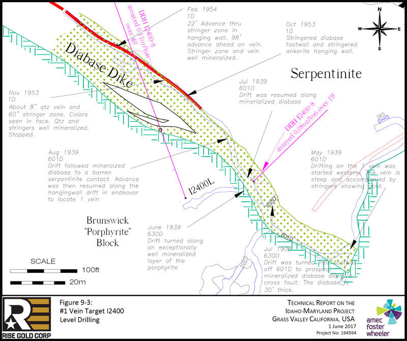
| Page 9-9 |
| | |
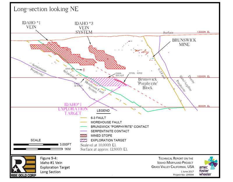
| Page 9-10 |
| | |
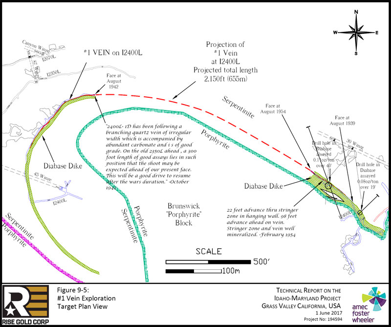
| Page 9-11 |
| | |
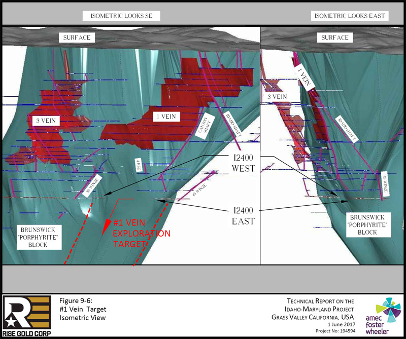
| Page 9-12 |
| | Technical Report on the Idaho-Maryland Project Grass Valley California, USA |
| 9.1.2 | Crackle Zone Exploration Target |
The Crackle Zone exploration target is a conceptual target based on an idea proposed by Bateman that mineralizing fluids responsible for the gold mineralization encountered at the Idaho-Maryland Mine may have formed a zone of intense quartz veins and stockwork within the Brunswick Block in response to the interaction of the Idaho, 6-3, and Morehouse faults. The Crackle Zone target generally lies beneath all current development and drilling but quartz vein and stockwork hosted gold mineralization identified by drilling, development, and mining of the 52 Vein and 60 Winze area may represent part of this target.
The 52 Vein was discovered during exploration development across the Brunswick Block from the Idaho #2 Vein to the Morehouse fault. Extensive stoping of the 52 Vein occurred over an area of approximately 850ft (259m) dip-length and 400ft (122m) strike-length. A change in stope direction near the inferred Morehouse fault observed on level plans may indicate the 52 Vein is influenced by the Morehouse fault. The 60 Winze explored the 52 Vein over a down-dip length of approximately 460ft (140m) until the vein pinched into fault gouge at the I2830L (Figure 9-7).
| Project No.: 194594 | Page 9-13 | |
| | |
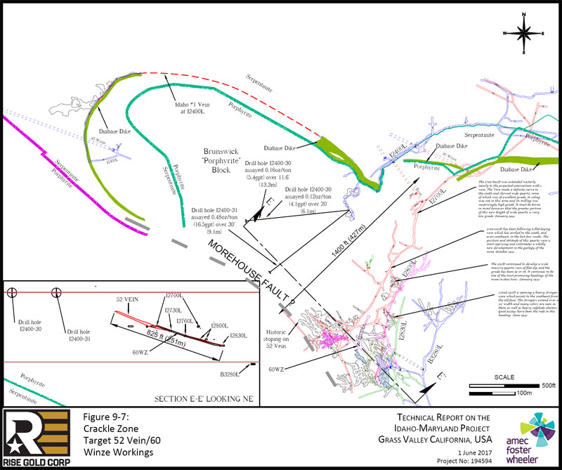
| Page 9-14 |
| | Technical Report on the Idaho-Maryland Project Grass Valley California, USA |
Historic operators collected 77 channel samples, taken on both walls of the 60 Winze at an average spacing of approximately 6ft (1.8m). The weighted average of all channel samples was 0.45oz/ton (15.5gpt) over 5.0ft (1.5m) and ranged as high as 2.28oz/ton (78gpt) over 5.8ft (1.8m). Channel sample results along the entire length of the 60 Winze are shown in Figure 9-8 and are tabulated in Table 9-3. Sample lengths in the figure are in inches. Au grades are in oz/ton. Au written in red refers to visible gold. Sampling is assumed to be left and right wall. Channel samples are assumed to represent true width of the quartz vein but information regarding channel sampling methods used to confirm this is not available. Rise assigned sample number starting at the south (bottom of Figure 9-8. Sample grades in the table are sample length-weighted.
Numerous historic diamond drill holes and historic records suggest that an extensive amount of stockwork mineralization is present in the walls of the 52 Vein. The historic diamond drilling was completed at poor angles to the mineralization, typically down dip and along strike. Drill hole I2400-31 intersected 0.48oz/ton (16.5gpt) over 30ft (9.1m). This intercept is located approximately 410ft (125m) up-dip from the top of the stoping of 52 Vein on I2700 level and may represent an up-dip extension of 52 Vein. Drill hole I2400-30 intersected an interval of 0.12oz/ton (4.1gpt) over 19.9ft (6.1m) and an interval of 0.16oz/ton (5.4gpt) over 43.7ft (13.3m). These mineralized intercepts may represent veins in the footwall of 52 Vein. The location of these drill holes is shown in Figure 9-1 and the results are summarized in Table 9-4. The true width of these intercepts cannot be calculated as there is insufficient data to confirm the orientation of the mineralization.
| Project No.: 194594 | Page 9-15 | |
| | |
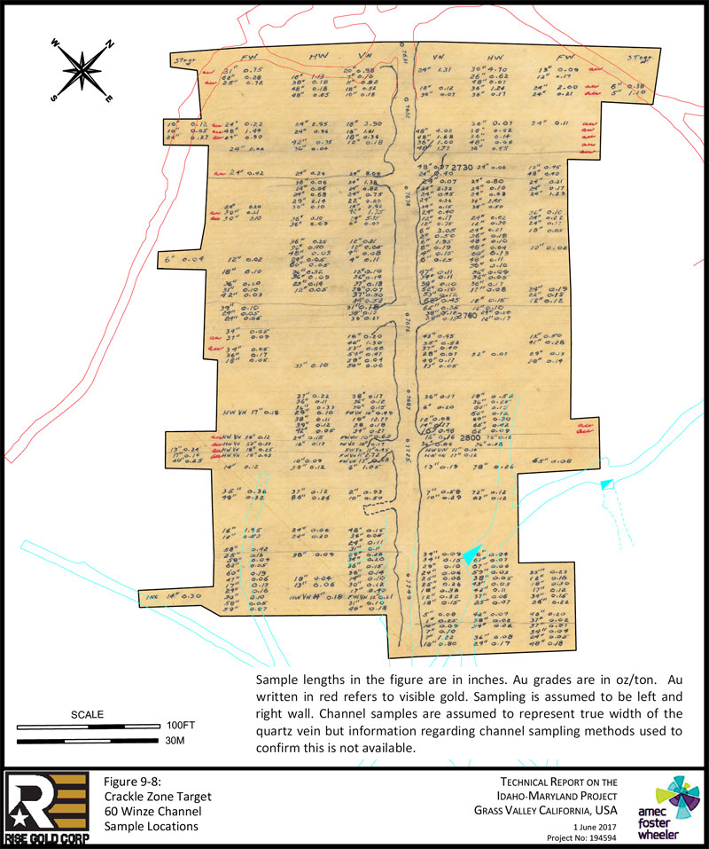
| Page 9-16 |
| | Technical Report on the Idaho-Maryland Project Grass Valley California, USA |
| Table 9-3: | Crackle Zone Target – 60 Winze Channel Sample Results; Results of Significantly Higher Grade Intervals Highlighted in Blue |
| 60 Winze - SW Wall | 60 Winze - NE Wall | 60 Winze - Average | 60 Winze - Average | |||||||||||||
| Channel | (Imperial) | (Imperial) | (Imperial) | (Metric) | ||||||||||||
| Sample | Au | Width | Au | Width | Au | Width | Au | Width | ||||||||
| # | (oz/ton) | (ft) | (oz/ton) | (ft) | (oz/ton) | (ft) | (gpt) | (m) | ||||||||
| 1 | 0.84 | 4.3 | 2.39 | 6.1 | 1.75 | 5.2 | 60.0 | 1.6 | ||||||||
| 2 | 0.42 | 7.4 | 0.48 | 3.2 | 0.44 | 5.3 | 15.1 | 1.6 | ||||||||
| 3 | 0.46 | 6.2 | 0.07 | 4.0 | 0.31 | 5.1 | 10.5 | 1.5 | ||||||||
| 4 | 0.27 | 5.5 | 1.16 | 7.0 | 0.77 | 6.3 | 26.3 | 1.9 | ||||||||
| 5 | 0.57 | 4.8 | 0.20 | 7.9 | 0.34 | 6.4 | 11.6 | 1.9 | ||||||||
| 6 | 1.94 | 6.3 | 0.09 | 5.0 | 1.12 | 5.7 | 38.5 | 1.7 | ||||||||
| 7 | 1.35 | 7.5 | 4.02 | 4.0 | 2.28 | 5.8 | 78.0 | 1.8 | ||||||||
| 8 | 0.52 | 5.5 | 1.02 | 7.0 | 0.80 | 6.3 | 27.5 | 1.9 | ||||||||
| 9 | 0.31 | 4.5 | 0.46 | 7.0 | 0.40 | 5.8 | 13.8 | 1.8 | ||||||||
| 10 | NO SAMPLE | 1.25 | 7.0 | 1.25 | 7.0 | 42.8 | 2.1 | |||||||||
| 11 | NO SAMPLE | 0.24 | 7.0 | 0.24 | 7.0 | 8.1 | 2.1 | |||||||||
| 12 | 2.92 | 6.0 | 1.07 | 6.0 | 1.99 | 6.0 | 68.3 | 1.8 | ||||||||
| 13 | 0.59 | 5.0 | 0.36 | 6.0 | 0.46 | 5.5 | 15.9 | 1.7 | ||||||||
| 14 | 0.44 | 4.0 | 0.86 | 6.0 | 0.69 | 5.0 | 23.8 | 1.5 | ||||||||
| 15 | 0.72 | 4.0 | 0.59 | 6.0 | 0.64 | 5.0 | 21.9 | 1.5 | ||||||||
| 16 | 1.32 | 4.3 | 2.21 | 5.0 | 1.80 | 4.6 | 61.8 | 1.4 | ||||||||
| 17 | 0.72 | 5.7 | 0.36 | 5.0 | 0.55 | 5.3 | 18.8 | 1.6 | ||||||||
| 18 | 1.11 | 6.0 | 0.22 | 5.0 | 0.70 | 5.5 | 24.2 | 1.7 | ||||||||
| 19 | 2.27 | 7.5 | 0.20 | 3.0 | 1.68 | 5.3 | 57.7 | 1.6 | ||||||||
| 20 | 0.09 | 3.5 | 0.35 | 4.0 | 0.23 | 3.8 | 7.7 | 1.1 | ||||||||
| 21 | NO SAMPLE | 0.78 | 2.5 | 0.78 | 2.5 | 26.7 | 0.8 | |||||||||
| 22 | NO SAMPLE | 0.20 | 3.2 | 0.20 | 3.2 | 6.7 | 1.0 | |||||||||
| 23 | 0.24 | 4.0 | 0.31 | 4.5 | 0.27 | 4.3 | 9.4 | 1.3 | ||||||||
| 24 | 0.40 | 3.0 | 0.19 | 0.5 | 0.37 | 1.8 | 12.7 | 0.5 | ||||||||
| 25 | 0.08 | 0.3 | 0.13 | 5.3 | 0.13 | 2.8 | 4.4 | 0.9 | ||||||||
| 26 | 0.11 | 0.3 | 0.13 | 4.5 | 0.12 | 2.4 | 4.3 | 0.7 | ||||||||
| 27 | NO SAMPLE | 0.10 | 3.0 | 0.10 | 3.0 | 3.4 | 0.9 | |||||||||
| 28 | 0.22 | 5.5 | 0.10 | 6.9 | 0.15 | 6.2 | 5.3 | 1.9 | ||||||||
| 29 | 0.12 | 6.0 | 0.11 | 2.8 | 0.11 | 4.4 | 3.9 | 1.3 | ||||||||
| Project No.: 194594 | Page 9-17 | |
| | Technical Report on the Idaho-Maryland Project Grass Valley California, USA |
| 60 Winze - SW Wall | 60 Winze - NE Wall | 60 Winze - Average | 60 Winze - Average | |||||||||||||
| Channel | (Imperial) | (Imperial) | (Imperial) | (Metric) | ||||||||||||
| Sample | Au | Width | Au | Width | Au | Width | Au | Width | ||||||||
| # | (oz/ton) | (ft) | (oz/ton) | (ft) | (oz/ton) | (ft) | (gpt) | (m) | ||||||||
| 30 | 0.18 | 8.0 | 0.13 | 6.2 | 0.16 | 7.1 | 5.4 | 2.2 | ||||||||
| 31 | 0.07 | 3.2 | 0.12 | 7.8 | 0.11 | 5.5 | 3.6 | 1.7 | ||||||||
| 32 | 0.50 | 3.1 | 0.12 | 6.3 | 0.25 | 4.7 | 8.5 | 1.4 | ||||||||
| 33 | 0.52 | 2.8 | 0.36 | 7.2 | 0.41 | 5.0 | 13.9 | 1.5 | ||||||||
| 34 | 0.14 | 5.8 | 0.31 | 6.4 | 0.23 | 6.1 | 7.8 | 1.9 | ||||||||
| 35 | 0.13 | 3.2 | 0.19 | 5.2 | 0.17 | 4.2 | 5.7 | 1.3 | ||||||||
| 36 | 0.19 | 5.3 | 0.16 | 3.8 | 0.18 | 4.5 | 6.0 | 1.4 | ||||||||
| 37 | 0.13 | 4.6 | 0.46 | 4.6 | 0.29 | 4.6 | 10.1 | 1.4 | ||||||||
| 38 | 1.30 | 3.8 | 0.39 | 6.3 | 0.73 | 5.1 | 25.1 | 1.5 | ||||||||
| 39 | 0.50 | 4.4 | 0.40 | 3.1 | 0.46 | 3.8 | 15.7 | 1.1 | ||||||||
| 40 | 0.35 | 7.5 | 0.09 | 7.4 | 0.22 | 7.5 | 7.6 | 2.3 | ||||||||
| 41 | NO SAMPLE | 0.16 | 6.4 | 0.16 | 6.4 | 5.5 | 2.0 | |||||||||
| 42 | 0.08 | 7.3 | NO SAMPLE | 0.08 | 7.3 | 2.6 | 2.2 | |||||||||
| 43 | 0.19 | 6.3 | 0.29 | 4.5 | 0.23 | 5.4 | 8.0 | 1.6 | ||||||||
| 44 | 0.12 | 6.0 | 0.25 | 3.0 | 0.16 | 4.5 | 5.5 | 1.4 | ||||||||
| 45 | 0.25 | 5.5 | 0.15 | 5.5 | 0.20 | 5.5 | 6.9 | 1.7 | ||||||||
| 46 | 0.19 | 4.7 | 0.12 | 5.0 | 0.16 | 4.8 | 5.3 | 1.5 | ||||||||
| 47 | 4.18 | 4.7 | 0.26 | 6.0 | 1.98 | 5.3 | 67.8 | 1.6 | ||||||||
| 48 | 0.15 | 5.6 | 0.38 | 6.6 | 0.27 | 6.1 | 9.3 | 1.9 | ||||||||
| 49 | 0.27 | 2.8 | 0.17 | 6.5 | 0.20 | 4.7 | 6.9 | 1.4 | ||||||||
| 50 | 0.20 | 6.1 | 0.13 | 7.2 | 0.16 | 6.6 | 5.5 | 2.0 | ||||||||
| 51 | 0.28 | 6.2 | 0.22 | 6.0 | 0.25 | 6.1 | 8.5 | 1.9 | ||||||||
| 52 | 0.30 | 3.5 | 0.14 | 0.9 | 0.27 | 2.2 | 9.1 | 0.7 | ||||||||
| 53 | 1.15 | 2.3 | 0.12 | 1.4 | 0.76 | 1.9 | 26.2 | 0.6 | ||||||||
| 54 | 0.23 | 5.3 | 0.08 | 5.4 | 0.15 | 5.3 | 5.3 | 1.6 | ||||||||
| 55 | 0.22 | 4.8 | 0.24 | 7.6 | 0.23 | 6.2 | 7.9 | 1.9 | ||||||||
| 56 | 0.26 | 6.2 | 0.16 | 6.6 | 0.21 | 6.4 | 7.1 | 1.9 | ||||||||
| 57 | 0.30 | 12.1 | 0.14 | 6.0 | 0.25 | 9.0 | 8.4 | 2.8 | ||||||||
| 58 | 0.45 | 7.3 | NO SAMPLE | 0.45 | 7.3 | 15.5 | 2.2 | |||||||||
| 59 | 0.31 | 3.0 | NO SAMPLE | 0.31 | 3.0 | 10.6 | 0.9 | |||||||||
| 60 | 0.11 | 2.0 | NO SAMPLE | 0.11 | 2.0 | 3.8 | 0.6 | |||||||||
| Project No.: 194594 | Page 9-18 | |
| | Technical Report on the Idaho-Maryland Project Grass Valley California, USA |
| 60 Winze - SW Wall | 60 Winze - NE Wall | 60 Winze - Average | 60 Winze - Average | |||||||||||||
| Channel | (Imperial) | (Imperial) | (Imperial) | (Metric) | ||||||||||||
| Sample | Au | Width | Au | Width | Au | Width | Au | Width | ||||||||
| # | (oz/ton) | (ft) | (oz/ton) | (ft) | (oz/ton) | (ft) | (gpt) | (m) | ||||||||
| 61 | 0.31 | 7.4 | NO SAMPLE | 0.31 | 7.4 | 10.7 | 2.3 | |||||||||
| 62 | 0.17 | 7.7 | 0.09 | 2.8 | 0.15 | 5.3 | 5.1 | 1.6 | ||||||||
| 63 | 0.20 | 2.8 | 0.10 | 8.4 | 0.12 | 5.6 | 4.2 | 1.7 | ||||||||
| 64 | 0.15 | 3.0 | 0.07 | 8.0 | 0.09 | 5.5 | 3.2 | 1.7 | ||||||||
| 65 | 0.17 | 8.0 | 0.16 | 4.9 | 0.17 | 6.5 | 5.7 | 2.0 | ||||||||
| 66 | 0.07 | 5.1 | 0.09 | 3.1 | 0.08 | 4.1 | 2.7 | 1.2 | ||||||||
| 67 | 0.11 | 5.0 | 0.28 | 3.6 | 0.18 | 4.3 | 6.2 | 1.3 | ||||||||
| 68 | 0.26 | 3.4 | 0.16 | 6.4 | 0.20 | 4.9 | 6.7 | 1.5 | ||||||||
| 69 | 0.14 | 4.7 | 0.13 | 6.9 | 0.14 | 5.8 | 4.7 | 1.8 | ||||||||
| 70 | 0.10 | 2.6 | 0.15 | 5.8 | 0.13 | 4.2 | 4.5 | 1.3 | ||||||||
| 71 | 0.12 | 8.8 | NO SAMPLE | 0.12 | 8.8 | 4.1 | 2.7 | |||||||||
| 72 | NO SAMPLE | 0.19 | 4.3 | 0.19 | 4.3 | 6.5 | 1.3 | |||||||||
| 73 | NO SAMPLE | 0.25 | 0.1 | 0.25 | 0.1 | 8.6 | 0.0 | |||||||||
| 74 | NO SAMPLE | 0.09 | 0.8 | 0.09 | 0.8 | 3.1 | 0.3 | |||||||||
| 75 | NO SAMPLE | 0.10 | 0.6 | 0.10 | 0.6 | 3.4 | 0.2 | |||||||||
| 76 | NO SAMPLE | 0.32 | 2.8 | 0.32 | 2.8 | 11.0 | 0.8 | |||||||||
| 77 | NO SAMPLE | 0.30 | 7.5 | 0.30 | 7.5 | 10.3 | 2.3 | |||||||||
| AVG | 0.53 | 5.1 | 0.40 | 5.1 | 0.45 | 5.0 | 15.5 | 1.5 | ||||||||
Note: Sample lengths are sum of stringer, FW, HW, and Vein. Sample grades are sample length weighted; Average grade is sample length weighted. Rise assigned sample number starting at the bottom of Figure 9-8.
| Project No.: 194594 | Page 9-19 | |
| | Technical Report on the Idaho-Maryland Project Grass Valley California, USA |
Table 9-4: Crackle Zone Target 52 Vein/60 Winze Area Drill Hole Intercepts
| Hole ID | Level | From (ft) | To (ft) | Interval (ft) | Au (oz/ton) | Interval (m) | Au (gpt) | |||||||
| I2400-31 | I2400 | 634.28 | 664.28 | 30.00 | 0.48 | 9.1 | 16.5 | |||||||
| Hole ID | Level | From (ft) | To (ft) | Interval (ft) | Au (oz/ton) | Interval (m) | Au (gpt) | |||||||
| I2400-30 | I2400 | 575.99 | 577.59 | 1.60 | 0.11 | 0.49 | 3.77 | |||||||
| I2400-30 | I2400 | 577.59 | 578.06 | 0.47 | 0.00 | 0.14 | 0.00 | |||||||
| I2400-30 | I2400 | 578.06 | 581.16 | 3.10 | 0.29 | 0.94 | 9.94 | |||||||
| I2400-30 | I2400 | 581.16 | 582.83 | 1.67 | 0.00 | 0.51 | 0.00 | |||||||
| I2400-30 | I2400 | 582.83 | 589.83 | 7.00 | 0.14 | 2.13 | 4.80 | |||||||
| I2400-30 | I2400 | 589.83 | 592.43 | 2.60 | 0.00 | 0.79 | 0.00 | |||||||
| I2400-30 | I2400 | 592.43 | 595.93 | 3.50 | 0.09 | 1.07 | 3.09 | |||||||
| Composite of Intercept | 19.9 ft @ | 0.12 oz/ton | 6.1 m@ | 4.1 gpt | ||||||||||
| Hole ID | Level | From (ft) | To (ft) | Interval (ft) | Au (oz/ton) | Interval (m) | Au (gpt) | |||||||
| I2400-30 | I2400 | 622.12 | 624.32 | 2.20 | 0.13 | 0.67 | 4.46 | |||||||
| I2400-30 | I2400 | 624.32 | 627.92 | 3.60 | 0.38 | 1.10 | 13.03 | |||||||
| I2400-30 | I2400 | 627.92 | 629.40 | 1.48 | 0.00 | 0.45 | 0.00 | |||||||
| I2400-30 | I2400 | 629.40 | 631.50 | 2.10 | 0.10 | 0.64 | 3.43 | |||||||
| I2400-30 | I2400 | 631.50 | 633.81 | 2.31 | 0.00 | 0.70 | 0.00 | |||||||
| I2400-30 | I2400 | 633.81 | 638.51 | 4.70 | 0.53 | 1.43 | 18.17 | |||||||
| I2400-30 | I2400 | 638.51 | 644.21 | 5.70 | 0.07 | 1.74 | 2.40 | |||||||
| I2400-30 | I2400 | 644.21 | 651.44 | 7.23 | 0.00 | 2.20 | 0.00 | |||||||
| I2400-30 | I2400 | 651.44 | 665.84 | 14.40 | 0.15 | 4.39 | 5.14 | |||||||
| Composite of Intercept | 43.7 ft @ | 0.16 oz/ton | 13.3 m@ | 5.4 gpt | ||||||||||
The Crackle Zone target forms a wedge-shaped area 2,000ft (610m) wide and 500ft to 1,00 0ft (152m to 305m) thick at the I2700 Level and plunging as much as 5,000ft (1,524m) to the south east where it pinches out against the intersection of the Idaho, Morehouse, and 6-3 Faults. Within this zone, gold mineralization may occur in shallow dipping quartz veins and irregular quartz stockworks in metavolcanic rocks that may be highly fractured due to the interaction of the Idaho, Morehouse, and 6-3 Faults as proposed by Bateman.
Figure 9-9 shows isometric view of the Crackle Zone target beneath the 52 Vein/60 Winze area. Figure 9-10 shows the numerous historic drill intercepts in the 60 Winze area and an estimated projection of the 3 major faults converging at depth. The Brunswick Block is shown to a depth of 5,000ft (1,524m) vertical.
| Project No.: 194594 | Page 9-20 | |
| | |
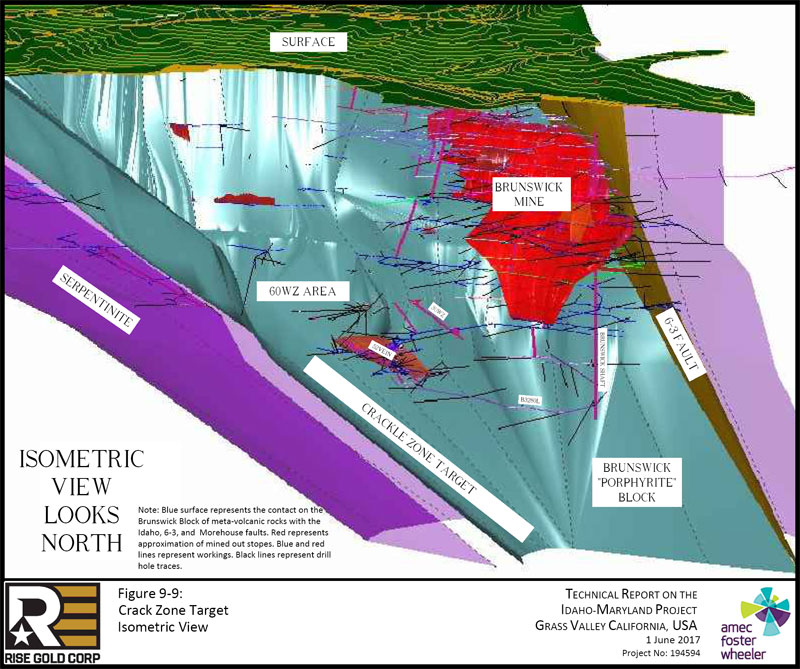
| Page 9-21 |
| | |
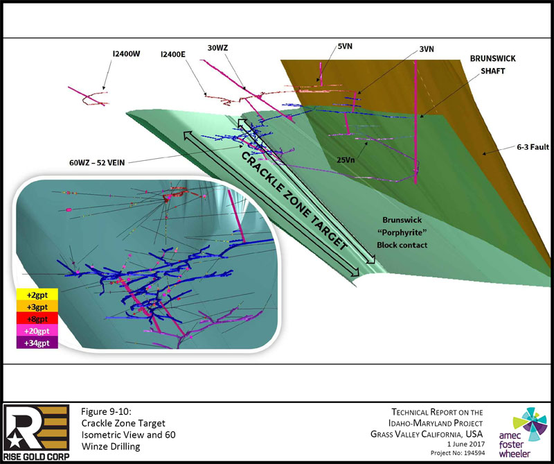
| Page 9-22 |
| | Technical Report on the Idaho-Maryland Project Grass Valley California, USA |
| 9.1.3 | Brunswick Exploration Targets |
The Brunswick area offers many areas with potential for discovery of mineralization, particularly the extension of Brunswick veins below the existing stoping and in the untested area in the immediate footwall of the 6-3 Fault.
| 9.1.3.1 | Down-dip Extension of Brunswick Veins |
At least seven major Brunswick veins are essentially unexplored below the 1600 Level. These parallel, vertically dipping mineralized veins were extensively mined above 1600L along continuous strike lengths ranging from 430ft (131m) to 1,000ft (305m) with continuous vertical heights reaching up to 1,000ft (305m). The Brunswick veins generally range from several inches up to 8ft (2.4m) in width. Below 1600 Level, development is limited to 1880L, 2300L, and 3280L; 3280L is the deepest level in Brunswick Mine. Two of the major veins (10 Vein and 16 Vein) have been partially explored and partially mined below 1600L, while five of the seven major veins (30 Vein, 18 Vein, 128 Vein, 31 Vein, and 1 Vein) have received minimal or no exploration below 1600L.
| 9.1.3.2 | 6-3 Fault Footwall |
In Brunswick Mine, the richest mineralization was typically found near the 6-3 Fault. Below 1600 Level, development in the southern region of the Brunswick Mine deviated to the west, away from the 6-3 Fault leaving a region of unexplored ground in the footwall adjacent to the fault approximately 500ft to 1,00 0ft (152m to 305m) thick, 1,000ft to 2,000ft (305m to 610m) wide, and 1,000ft to 3,000ft (305m to 914m) down-dip.
| Project No.: 194594 | Page 9-23 | |
| | Technical Report on the Idaho-Maryland Project Grass Valley California, USA |
| 9.1.4 | 3 Vein System Exploration Target |
The Idaho #3 Vein was mined continuously over a vertical distance of approximately 1500ft (460m) and an average horizontal strike length of approximately 700ft (210m). There were several important veins which splayed from the main #3 Vein, forming the larger 3 Vein system. The most important of which were named the 5 Vein, 13 Vein, and 22 Vein. The 3 Vein ranged in dip from 45° to 70°, with an average dip of approximately 55°. An average vein width of approximately 5ft (1.5m) was typical but in places reached widths of over 20ft (6m).
Similar to the Idaho #1 Vein, the diabase dikes adjacent to the quartz veins were found to be mineralized in many areas. There were some areas in the 3 Vein system where highly mineralized diabase was mined in important volumes. For example, the occurrence of mineralized diabase adjacent to the quartz vein in 13 Vein on Idaho 1250 Level allowed mining widths of up to 36ft (11m).
In addition to down dip potential of the 3 Vein system there is potential for discovery of mineralization within the serpentinite unit.
| 9.1.4.1 | 3 Vein - Rose Garden Target |
In 1940, mineralization was intersected by exploration drifting 2,000ft (610m) east of the #3 Vein on I2000 Level. The mine operator was following the Idaho #5 Vein towards the 6-3 Fault and located the 23 Vein by diamond drilling. This area, known as the 23 Vein or Rose Garden, dips to the northwest as opposed to the southwest and is hosted entirely in serpentinite. The 23 Vein was followed along strike to the southwest and was found to intersected the 6-3 Fault.
The Rose Garden is hosted entirely in serpentinite and is quite narrow but was noted to contain abundant visible gold. Historic operators called this zone the “Rose Garden” due to the poor ventilation in the dead-end heading resulting from the long distance from the main level access. In February 1941, development of an exploration raise (#1 Raise) commenced on 2000L; #1 Raise was developed 90ft (27m) along the dip of 23 Vein. In June 1942, downward development of a winze (23 Winze) commenced in the same location. 23 Winze was halted in October 1942 due to the war time closure after reaching a vertical depth of 85ft (26m) below Idaho 2000L. Mine geologists reported that the quartz at the bottom of 23 Winze was of “good assay value” and recommended that development of the winze and sub-drifting from the winze be recommenced after the wars duration. During the war, the access tunnels to this area became
| Project No.: 194594 | Page 9-24 | |
| | Technical Report on the Idaho-Maryland Project Grass Valley California, USA |
inaccessible and no work was ever recommenced in the Rose Garden. An effort to re-access the area in 1951 was commenced but was subsequently abandoned due to lack of resources.
A Plan View of the Rose Garden area is shown in Figure 9-11.
Historic mine operators collected 40 channel samples in the 23 Winze which averaged 0.42oz/ton (14.3gpt) over 3.5ft (1.1m), with values up to 0.80oz/ton (27gpt) over 7.8ft (2.4m) and 5.36oz/ton (184gpt) over 1.1ft (0.3m). Channel sample results along 23 Winze are tabulated in Table 9-5.
In the #1 Raise, historic mine operators collected 31 channel samples. Samples in the #1 Raise averaged 0.96oz/ton (33.1gpt) over 1.9ft (0.6m) with values up to 1.74oz/ton (60gpt) over 4.5ft (1.4m) and 14.10oz (483gpt) per ton over 0.5ft (0.2m). Channel sample results, by historic operators, along #1 Raise are tabulated in Table 9-6.
Channel sample locations are shown in Figure 9-12. Channel sample lengths are assumed to represent true width of the quartz vein but information regarding channel sampling methods used to confirm this is not available.
| Project No.: 194594 | Page 9-25 | |
| | |
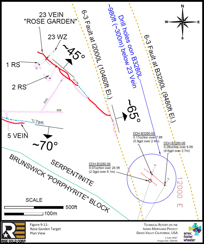
| Page 9-26 |
| | Technical Report on the Idaho-Maryland Project Grass Valley California, USA |
| Figure 9-12: | Rose Garden 23 Winze & #1 Raise Channel Sample Locations |
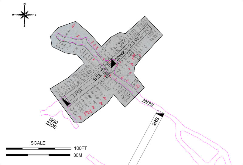
Sample lengths in the figure are in inches. Au grades are in oz/ton. Au written in red refers to visible gold. Sampling is assumed to be left and right wall. Channel samples are assumed to represent true width of the quartz vein but information regarding channel sampling methods used to confirm this is not available.
| Project No.: 194594 | Page 9-27 | |
| | Technical Report on the Idaho-Maryland Project Grass Valley California, USA |
| Table 9-5: | 3 Vein System – Rose Garden 23 Winze Channel Sample Results; Results of Significantly Higher Grade Intervals Highlighted in Blue |
| Channel | Winze North Wall | Winze South Wall | Winze - Average | Winze - Average | ||||||||||||
| Sample | Assay | Width | Assay | Width | Assay | Width | Assay | Width | ||||||||
| # | (oz/ton) | (ft) | (oz/ton) | (ft) | (oz/ton) | (ft) | (gpt) | (m) | ||||||||
| 1 | 0.38 | 0.83 | 0.05 | 9.25 | 0.08 | 5.0 | 2.6 | 1.5 | ||||||||
| 2 | 0.55 | 9.33 | 0.06 | 5.67 | 0.36 | 7.5 | 12.5 | 2.3 | ||||||||
| 3 | 0.38 | 6.00 | 0.06 | 0.50 | 0.36 | 3.3 | 12.2 | 1.0 | ||||||||
| 4 | 0.43 | 4.83 | 0.23 | 5.00 | 0.33 | 4.9 | 11.3 | 1.5 | ||||||||
| 5 | 0.22 | 4.17 | 0.08 | 5.00 | 0.14 | 4.6 | 4.9 | 1.4 | ||||||||
| 6 | 0.10 | 2.50 | 0.37 | 2.50 | 0.24 | 2.5 | 8.1 | 0.8 | ||||||||
| 7 | 0.19 | 3.00 | NO SAMPLE | 0.19 | 3.0 | 6.5 | 0.9 | |||||||||
| 8 | 0.07 | 1.67 | NO SAMPLE | 0.07 | 1.7 | 2.4 | 0.5 | |||||||||
| 9 | 0.66 | 1.83 | 0.07 | 4.00 | 0.26 | 2.9 | 8.8 | 0.9 | ||||||||
| 10 | 0.77 | 1.33 | 0.25 | 1.00 | 0.55 | 1.2 | 18.8 | 0.4 | ||||||||
| 11 | 0.80 | 7.83 | 0.85 | 5.25 | 0.82 | 6.5 | 28.1 | 2.0 | ||||||||
| 12 | 0.18 | 2.42 | 0.06 | 7.33 | 0.09 | 4.9 | 3.1 | 1.5 | ||||||||
| 13 | 0.92 | 2.50 | 0.16 | 10.00 | 0.31 | 6.3 | 10.7 | 1.9 | ||||||||
| 14 | 1.79 | 1.75 | 0.12 | 7.00 | 0.45 | 4.4 | 15.6 | 1.3 | ||||||||
| 15 | 2.19 | 1.33 | 0.05 | 5.67 | 0.46 | 3.5 | 15.7 | 1.1 | ||||||||
| 16 | 5.36 | 1.08 | 0.10 | 5.50 | 0.97 | 3.3 | 33.1 | 1.0 | ||||||||
| 17 | 2.28 | 0.33 | 5.15 | 0.33 | 3.72 | 0.3 | 127.4 | 0.1 | ||||||||
| 18 | 0.86 | 1.50 | 0.07 | 6.25 | 0.22 | 3.9 | 7.6 | 1.2 | ||||||||
| 19 | 1.70 | 1.50 | 0.01 | 4.00 | 0.47 | 2.8 | 16.1 | 0.8 | ||||||||
| 20 | 2.56 | 0.25 | 5.77 | 0.25 | 4.17 | 0.3 | 142.8 | 0.1 | ||||||||
| 21 | 4.75 | 1.08 | 0.22 | 2.83 | 1.47 | 2.0 | 50.5 | 0.6 | ||||||||
| AVG | 0.42 | 3.5 | 14.3 | 1.1 | ||||||||||||
Note: Average grade is sample length weighted. Rise Assigned sample number starting at the top right of Figure 9-12.
| Project No.: 194594 | Page 9-28 | |
| | Technical Report on the Idaho-Maryland Project Grass Valley California, USA |
| Table 9-6: | 3 Vein System – Rose Garden #1 Raise Channel Sample Results; Results of Significantly Higher Grade Intervals Highlighted in Blue |
| Channel | Raise North Wall | Raise South Wall | Raise - Average | Raise - Average | ||||||||||||
| Sample | Assay | Width | Assay | Width | Assay | Width | Assay | Width | ||||||||
| # | (oz/ton) | (ft) | (oz/ton) | (ft) | (oz/ton) | (ft) | (gpt) | (m) | ||||||||
| 1 | 1.34 | 0.50 | 1.34 | 0.5 | 45.9 | 0.2 | ||||||||||
| 2 | 4.25 | 0.50 | 2.64 | 1.67 | 3.01 | 1.1 | 103.3 | 0.3 | ||||||||
| 3 | 0.23 | 1.67 | 0.42 | 2.50 | 0.34 | 2.1 | 11.8 | 0.6 | ||||||||
| 4 | 0.08 | 1.33 | 0.08 | 1.3 | 2.7 | 0.4 | ||||||||||
| 5 | 1.74 | 4.50 | 0.09 | 2.50 | 1.15 | 3.5 | 39.5 | 1.1 | ||||||||
| 6 | 0.87 | 1.00 | 0.27 | 0.92 | 0.58 | 1.0 | 20.0 | 0.3 | ||||||||
| 7 | 1.68 | 1.08 | 0.06 | 5.67 | 0.32 | 3.4 | 11.0 | 1.0 | ||||||||
| 8 | 1.11 | 1.17 | 1.11 | 1.2 | 38.1 | 0.4 | ||||||||||
| 9 | 2.68 | 2.08 | 1.88 | 3.50 | 2.18 | 2.8 | 74.7 | 0.9 | ||||||||
| 10 | 1.92 | 2.58 | 0.23 | 2.83 | 1.04 | 2.7 | 35.5 | 0.8 | ||||||||
| 11 | 1.72 | 0.50 | 1.72 | 0.5 | 59.0 | 0.2 | ||||||||||
| 12 | 14.10 | 0.50 | 0.88 | 3.00 | 2.77 | 1.8 | 94.9 | 0.5 | ||||||||
| 13 | 2.41 | 1.17 | 0.30 | 1.75 | 1.14 | 1.5 | 39.2 | 0.4 | ||||||||
| 14 | 1.75 | 0.92 | 0.15 | 5.67 | 0.37 | 3.3 | 12.8 | 1.0 | ||||||||
| 15 | 2.36 | 0.58 | 0.27 | 2.00 | 0.74 | 1.3 | 25.4 | 0.4 | ||||||||
| 16 | 1.27 | 1.17 | 0.08 | 4.25 | 0.34 | 2.7 | 11.5 | 0.8 | ||||||||
| 17 | 0.98 | 1.25 | 0.05 | 3.67 | 0.29 | 2.5 | 9.8 | 0.7 | ||||||||
| AVG | 0.96 | 1.9 | 33.1 | 0.6 | ||||||||||||
Note: Average grade is sample length weighted. Rise assigned sample number starting at the top right of Figure 9-12.
There are no historic exploration drill holes or mine workings which explore the area below 23 Vein. However, on 3280L there are several promising historic mineralized drill intercepts in the general area below the Rose Garden which may be related and present exploration targets. In 1951, drill hole B3280-08 intersected 0.28oz/ton (9.6gpt) over 9.0ft (2.7m) in mineralized diabase and drill hole B3280-09 intersected 0.07oz/ton (2.5gpt) over 26.5ft (8.1m) and 0.17oz/ton (5.8gpt) over 7.8ft (2.4m), both of which were in serpentinite. These drill holes are located approximately 1,350ft (410m) horizontally to the southeast and 1,650ft (500m) vertically downward from the 23 Vein winze as shown in Figure 9-11. The location of these drill holes is shown in Figure 9-1 and the results are summarized in Table 9-7. The true width of mineralization cannot be calculated as there is not enough information to determine the orientation of the mineralization with certainty.
| Project No.: 194594 | Page 9-29 | |
| | Technical Report on the Idaho-Maryland Project Grass Valley California, USA |
Table 9-7: Rose Garden Area Drill Hole Intercepts
| Diabase | ||||||||||||||
| Hole ID | Level | From (ft) | To (ft) | Interval (ft) | Au (oz/ton) | Interval (m) | Au (gpt) | |||||||
| B3280-8 | B3280 | 626.12 | 629.62 | 3.50 | 0.14 | 1.07 | 4.80 | |||||||
| B3280-8 | B3280 | 629.62 | 632.22 | 2.60 | 0.06 | 0.79 | 2.06 | |||||||
| B3280-8 | B3280 | 632.22 | 635.12 | 2.90 | 0.65 | 0.88 | 22.29 | |||||||
| Composite of Intercept | 9.0 ft @ | 0.28 oz/ton | 2.7 m @ | 9.6 gpt | ||||||||||
| Serpentinite | ||||||||||||||
| Hole ID | Level | From (ft) | To (ft) | Interval (ft) | Au (oz/ton) | Interval (m) | Au (gpt) | |||||||
| B3280-9 | B3280 | 603.60 | 606.80 | 3.20 | 0.04 | 0.98 | 1.37 | |||||||
| B3280-9 | B3280 | 606.80 | 610.00 | 3.20 | 0.10 | 0.98 | 3.43 | |||||||
| B3280-9 | B3280 | 610.00 | 614.93 | 4.93 | 0.00 | 1.50 | 0.00 | |||||||
| B3280-9 | B3280 | 614.93 | 617.03 | 2.10 | 0.10 | 0.64 | 3.43 | |||||||
| B3280-9 | B3280 | 617.03 | 618.43 | 1.40 | 0.08 | 0.43 | 2.74 | |||||||
| B3280-9 | B3280 | 618.43 | 621.62 | 3.19 | 0.00 | 0.97 | 0.00 | |||||||
| B3280-9 | B3280 | 621.62 | 625.12 | 3.50 | 0.25 | 1.07 | 8.57 | |||||||
| B3280-9 | B3280 | 625.12 | 626.62 | 1.50 | 0.02 | 0.46 | 0.69 | |||||||
| B3280-9 | B3280 | 626.62 | 630.12 | 3.50 | 0.07 | 1.07 | 2.40 | |||||||
| Composite of Intercept | 26.5 ft @ | 0.07 oz/ton | 8.1 m @ | 2.5 gpt | ||||||||||
| Serpentinite | ||||||||||||||
| Hole ID | Level | From (ft) | To (ft) | Interval (ft) | Au (oz/ton) | Interval (m) | Au (gpt) | |||||||
| B3280-9 | B3280 | 668.15 | 673.65 | 5.50 | 0.18 | 1.68 | 6.17 | |||||||
| B3280-9 | B3280 | 673.76 | 676.06 | 2.30 | 0.14 | 0.70 | 4.80 | |||||||
| Composite of Intercept | 7.8 ft @ | 0.17 oz/ton | 2.4 m @ | 5.8 gpt | ||||||||||
The 23 Vein at the Rose Garden appears to be unusually strong for a vein hosted completely in serpentinite. There may be a relationship between the 23 Vein and the 6-3 Fault and this area is virtually unexplored both to depth and upwards towards surface. Drill holes below the 23 Vein on B3280 level are not likely the same mineralized structure but may be a parallel or related structure to the 23 Vein as they are in a similar relative position to the 6-3 Fault. This area presents an new exploration target within the sepentinite surrounding the Brunswick Block especially in areas where the fault or other related structures may intersect brittle rocks such as diabase dikes.
| Project No.: 194594 | Page 9-30 | |
| | Technical Report on the Idaho-Maryland Project Grass Valley California, USA |
| 10.0 | DRILLING |
Rise Gold Corp has not drilled the property. Rise prepared a drill hole database derived from information contained in the collection of historic documents and records acquired through the purchase of the Idaho-Maryland Mine Property. The drill hole database is divided into Idaho-Maryland Mine drilling completed before the mine shut down in 1956 (Idaho-Maryland Drilling) and Emgold drilling completed in 2004 (Emgold Drilling).
| 10.1 | Idaho-Maryland Mine Drilling |
Diamond drill logs for the historical drilling at I-M Mine are not available. Diamond drill hole collar data was derived from a “Drillhole Locations” historical binder. Drill hole lithology and assay data was derived from scaled and positioned level plans. There are four main types of level plans:
| 1. | Mine Level Plan – these include detailed geological mapping of rock types, veins, geologic structures, vein orientations, survey data, as well as other data. |
| 2. | Stope Level Plan – these include detailed stope locations. |
| 3. | Assay Level Plan – these include assay results of chip samples and diamond drill holes. |
| 4. | Geologic Level Plan – these include geologic information. |
Rise scanned all level plans using a large-format scanner and saved to an electronic file database. Subsequently, all level plans were inserted as raster images into AutoCAD where they were scaled and positioned. The raster images were corrected using the north-south 200ft (61m) level plan grid to correct distortions in distance and shape. Finally, all scaled and positioned raster images were saved to a Promine database.
Drill hole lithology and assay data are typically detailed on the main Mine Level Plans, and are commonly shown on the other plans. Rise scanned and transcribed drill hole lithology and assay data from all level plans.
Lithology and assay data intervals were measured from the drill hole collar along the drill hole trace. Rise assumed that inclined or declined holes are projected to plan view on the level plans. The unit and assay intervals were trigonometrically defined using the drill hole dip assuming that the dip of the drill hole collar remains constant for the length of each drill hole. Drill holes with no lithologic or assay data were left blank and “no data” is noted as a comment in the DDH database.
| Project No.: 194594 | Page 10-1 | |
| | Technical Report on the Idaho-Maryland Project Grass Valley California, USA |
Information on surveying, logging and sampling methods by previous operators is limited. Sampling of drill holes appears to have been completed along intercepts of most quartz veins. Core recovery information of drill holes is recorded when there is significant “core loss”.
Diamond drill holes reportedly have a diameter of 7/8” (EX-size). No core exists to confirm this.
| 10.1.1 | Collar Locations |
The following drill hole collar and orientation data has been gathered from the “Drillhole Locations” binder:
| ● | Mine (Idaho/Brunswick) |
| ● | Level |
| ● | Drill hole number |
| ● | Strike (converted from quadrant to azimuth) |
| ● | Dip (+/- degrees) |
| ● | Northing (ft) |
| ● | Easting (ft) |
| ● | Drill hole Length (ft) |
Rise named the drill holes according to mine, level, and drill hole number. For example, the first hole drilled in Brunswick Mine on the 2000 level was named B2000-1.
Elevation data for surface drill holes were taken from the topography at the identified drill hole collar location. Elevation data for Idaho and Brunswick underground diamond drill holes are assumed to be 3ft / 1m (estimated height of the diamond drill pivot point) above the drift floor elevation determined from mine survey data. Survey stations are recorded on the Mine Level Plans and detailed historic survey records are documented by mine level in multiple historic binders. In addition, elevations of the survey station are typically written on the Mine Level Plans.
Collar locations are reported at elevations above sea level. The common practice at the Idaho-Maryland Mine was to report sea level at 10,000ft so drill hole elevations are reported as elevation +10,000ft.
| Project No.: 194594 | Page 10-2 | |
| | Technical Report on the Idaho-Maryland Project Grass Valley California, USA |
Drill hole lengths range from 5ft to 962ft (1.5m to 293.2m) and average 281ft (85.8m). Drill collar statistical data is summarized in Table 10-1. The holes were drilled at various azimuths, with a tendency to a northeast or southwest direction.
Rise compared digital drill holes with scanned level plans to confirm the database drill hole collar, orientation, lithology and assay data.
Drill hole locations for Idaho-Maryland Mine historic drilling are shown in Figure 10-1.
Table 10-1: Drill Collar Statistical Data Summary of the Drill Hole Database
| Easting (ft) | Northing (ft) | Elevation (ft) | Azimuth | Dip | DDH Length (ft) | |||||||
| Mean | 11,227 | 156 | 8 | 281 | ||||||||
| Median | 11,460 | 177 | - | 253 | ||||||||
| Mode | 10,455 | - | - | 185 | ||||||||
| Minimum | 2,566 | 2,055 | 9,472 | 0 | - 90 | 5 | ||||||
| Maximum | 13,590 | 13,004 | 12,905 | 360 | 90 | 962 | ||||||
| Count | 803 | 803 | 783 | 815 | 819 | 832 |
| 10.1.2 | Down Hole Surveys |
No down hole survey data exists for the historical drill holes. Collar azimuths and dips are assumed for the entire length of the drill hole.
| 10.1.3 | Lithology |
Rise transcribed lithology from the level plans into the database. Lithology codes reported in the Rise database are summarized in Table 10-2.
| Project No.: 194594 | Page 10-3 | |
| | Technical Report on the Idaho-Maryland Project Grass Valley California, USA |
Table 10-2: Drill Hole Database Lithology Summary
| Lith Code | Description | Count of Intersections | Sum of Length of Intersections (ft) | |||
| ak | Ankerite | 749 | 16,728 | |||
| anh | Anhydrite/Gypsum | 2 | 8 | |||
| cb | Carbonate | 16 | 9 | |||
| ch | Chert | 21 | 212 | |||
| db | Diabase | 482 | 7,905 | |||
| di | Diorite | 128 | 2,239 | |||
| fa | Fault or Gouge | 288 | 459 | |||
| fs | Feldspar | 1 | 3 | |||
| gb | Gabbro | 179 | 2,828 | |||
| nc | no core | 64 | 338 | |||
| pr | Peridotite | 12 | 223 | |||
| pt | Porphyrite | 1,231 | 70,058 | |||
| qz | Quartz | 600 | 1,019 | |||
| sp | Serpentinite | 613 | 34,641 | |||
| sst | Sandstone | 6 | 48 | |||
| st | Slate | 163 | 5,088 |
| 10.1.4 | Assays |
Assay certificates are not available for the historic drill holes. Gold assay data was collected by Rise from the Assay Level Plans.
Assay data assumptions include the following:
| ● | Au assay data is either displayed in oz/ton or in $/ton on the Assay Level Plans. Dollar per ton values have been converted to oz/ton, assuming a fixed value of $35USD/oz of gold. |
| ● | Au intervals denoted with trace (Tr) oz/ton gold are reported as 0.01 oz/ton and assay intervals reported as “nil” are reported as 0.00 oz/ton. |
Sample lengths in the database range from 0.2ft to 465ft (0.1m to 142m). The nominal sample length is 1ft (0.3m). Records indicate that typically trace amounts of gold were observed for sample lengths greater than 20ft (6.1m).
| Project No.: 194594 | Page 10-4 | |
| | Technical Report on the Idaho-Maryland Project Grass Valley California, USA |
| 10.1.5 | Channel Sampling |
In most cases, channel samples taken along lateral/vertical development appear to have been selected along the widths of the quartz vein at approximately 6ft (1.8m) intervals, although interval length may vary. Level plans commonly show channel sample results recorded on both sides of a working indicating the vein was sampled on both sides. There is no detailed information on channel sampling procedures. A 1.75 mine call factor discussed in reports suggests channel sampling may have significantly underestimated the grades. Rise has tabled select channel sample results but has not yet digitized the location for presentation in the 3D model.
| 10.2 | Emgold Drilling |
Rise received the Emgold drill hole database from the BET Group in electronic format and imported to a Minesight Torque database. During the import process drill hole length inconsistencies, and interval gaps and overlaps were corrected. There were some errors observed in the Emgold data which were not resolved. The database included collar, lithology and assay information. Downhole survey data was not received. Rise also received drill logs in PDF format for 5 of the 38 holes and multiple binders of sample descriptions for the samples sent for assay. No assay certificates or the survey sheets were received.
The Emgold database consists of 31 surface exploration diamond drill holes totalling 21,335ft (6,503m) and 7 surface geotechnical holes totalling 3,537ft (1078m) completed in 2003 and 2004. Hole lengths ranged from 139ft to 1,706ft (42m to 520m). Dips ranged from -26° to -79°. The majority of holes were drilled in north facing fans. Sample lengths range from 0.3ft to 12ft (0.1m to 3.7m). The nominal sample length is 3ft (1m).
The Emgold exploration drilling focused on the westernmost near surface portion of Idaho #1 Vein. Drill holes intersected serpentinite and some vein material reinforced that mineralization is coarse in nature and confined to vein quartz and vein shears. The Emgold geotechnical drilling focused on a central area of the Brunswick Block in the area proposed room and pillar mine to support a proposed ceramic tile plant.
Historic drill hole locations for Idaho-Maryland Mine and Emgold drilling are shown in Figure 10-1.
| Project No.: 194594 | Page 10-5 | |
| | |
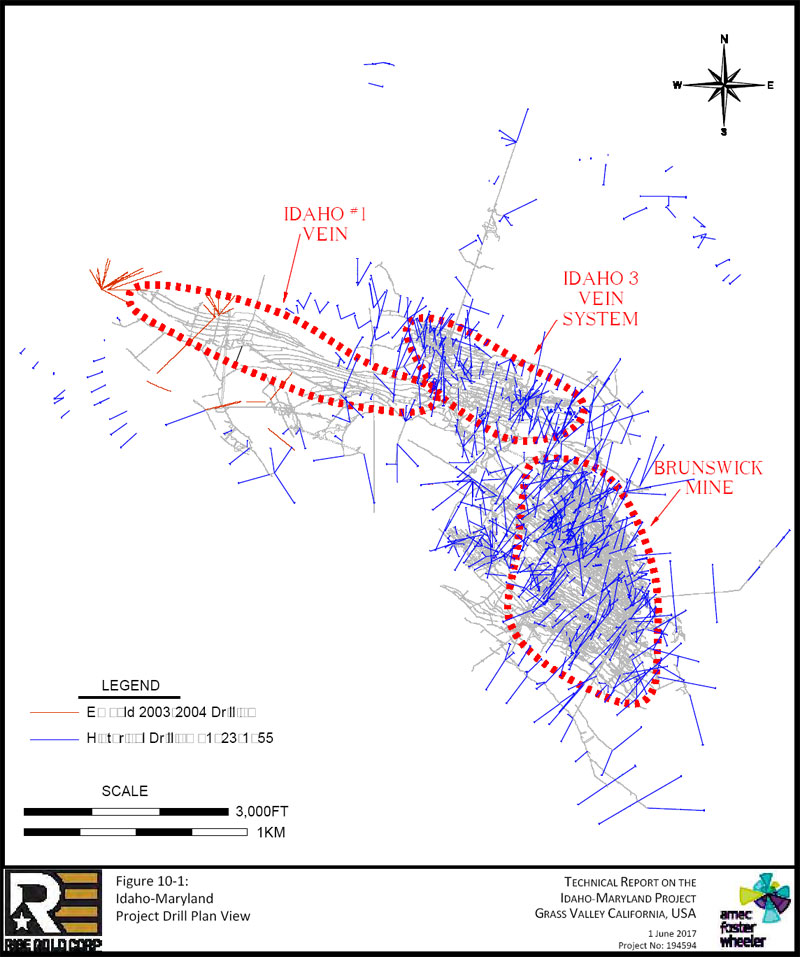
| Page 10-6 |
| | Technical Report on the Idaho-Maryland Project Grass Valley California, USA |
| 11.0 | SAMPLE PREPARATION, ANALYSES AND SECURITY |
There is no detailed information describing sample preparation, analysis and security procedures applied by mine operators before 2002. The historical samples are reportedly fire-assayed at former mine site laboratories. No records exist of any QA/QC program.
Emgold sample preparation, analysis and security procedures for core collected by Emgold are described in a 2009 Technical Report prepared by Robert Pease, P.G., for Emgold titled “Idaho-Maryland Mine Project, Grass Valley CA”. Three-foot core samples were cut in half by a wet saw. The half core samples were put in a sample bag, tagged, and shipped to a laboratory. All samples were crushed to 80% passing -10 mesh, rotary split to a 500g subsample which was pulverized to 95% passing -150 mesh. All samples were analyzed using screened metallics fire assay methods. The QAQC program used Standard Reference Materials, blank samples, coarse reject and pulp duplicate samples, and third party laboratory check assays. Insertion rate of SRMs and duplicates was approximately 1 in 20 samples. Blanks were only inserted immediately following mineralized intervals. The control samples were reportedly used to successfully control the assay quality process.
| Project No.: 194594 | Page 11-1 | |
| | Technical Report on the Idaho-Maryland Project Grass Valley California, USA |
| 12.0 | DATA VERIFICATION |
Data verification by Amec Foster Wheeler for the Idaho-Maryland Mine Property included a site visit, review of the historical documents, study of geological reports, and review of the transcription and modelling conducted by Rise.
| 12.1 | Historical Data Verification |
Mr. Kulla inspected Rise’s 3D model on screen, reviewed several historical reports, and reviewed many historical documents including cross sections and level plans used to prepare the model. Tables reported herein were spot checked against originals. The drill hole database was not verified; however, drilling is not used extensively to support the reported exploration targets.
Mr. Kulla did not assess previous Idaho-Maryland Mine operators or Emgold drilling sampling and assay quality. The Emgold drilling focused on shallow mineralization not considered part of the exploration targets described in this Report.
Although Rise has carefully digitized and checked the locations and values of drill hole results from level plans and other documents, the absence of drill hole related documentation such as drill logs, drill hole deviation, core recovery and density measurements, assay certificates, and possible channel sample grade biases could materially impact the accuracy and reliability of the reported results. The Rise database is suitable for exploration targeting.
| 12.2 | March 2017 Site Visit |
Mr. Greg Kulla conducted a site visit to the Idaho-Maryland Mine Property near Grass Valley, California on the 29th of March 2017. During the site visit Mr. Kulla inspected Rise’s surface land holdings, including the Brunswick land and the Idaho land, and the Mill Site Property, to which Rise holds an option to purchase. Mr. Kulla conducted a reconnaissance across the Brunswick and Mill Site land and inspected potential dill sites for the surface diamond drill exploration program proposed herein. During the reconnaissance, Mr. Kulla observed the decommissioned and locked New Brunswick Mine shaft, displayed in Figure 12-1, and the Union Hill Mine shaft on the Brunswick lands. The Mill Site Property, adjacent the Brunswick land, is displayed in Figure 12-2 and Figure 12-3.
| Project No.: 194594 | Page 12-1 | |
| | Technical Report on the Idaho-Maryland Project Grass Valley California, USA |
Additionally, Mr. Kulla visited the historical “Round Hole Shaft”, a ventilation shaft used during historic operation of the Idaho-Maryland Mine. The Round Hole Shaft is not within Rise’s current land holdings.
On the 30th of March 2017, Mr. Kulla met with Rise’s attorney, Mr. Braiden Chadwick, at Mitchell Chadwick’s office in Roseville, California to discuss mineral rights, surface rights, and permitting with respect to the Idaho-Maryland Mine Property.
Figure 12-1: Concrete Rock Silo Adjacent the Brunswick Shaft; View Looking West
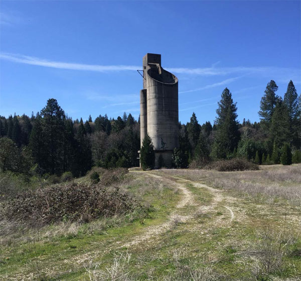
| Project No.: 194594 | Page 12-2 | |
| | Technical Report on the Idaho-Maryland Project Grass Valley California, USA |
Figure 12-2: Mill Site Property, View Looking Southeast
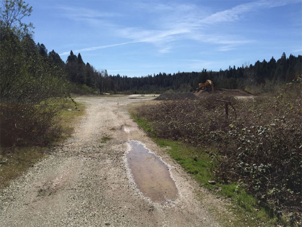
Figure 12-3: Mill Site Property, View Looking Northeast
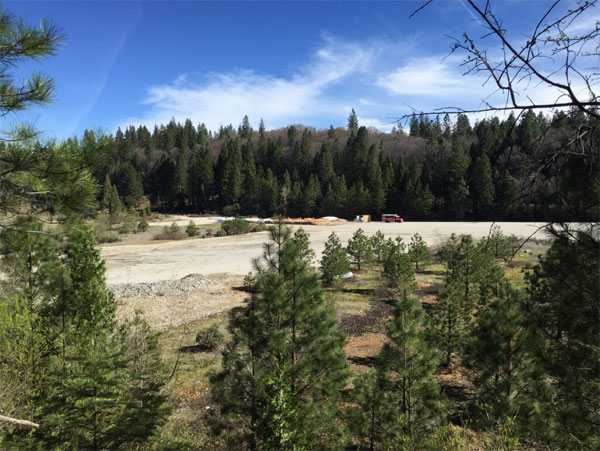
| Project No.: 194594 | Page 12-3 | |
| | Technical Report on the Idaho-Maryland Project Grass Valley California, USA |
| 13.0 | MINERAL PROCESSING AND METALLURGICAL TESTING |
The Company has conducted no mineral processing or metallurgical testing analyses on the Idaho-Maryland Mine Property. A significant amount of production has occurred on the property which confirms that gold can be recovered, mainly by gravity and flotation methods. Nearly all gold at the I-M Mine is free milling, as demonstrated by cyanide leaching of concentrates and tailings by the Mine during past production.
Historical metallurgy is discussed in Section 6.5 of this Report.
| Project No.: 194594 | Page 13-1 | |
| | Technical Report on the Idaho-Maryland Project Grass Valley California, USA |
| 14.0 | MINERAL RESOURCE ESTIMATES |
The present Report does not include an estimate of mineral resources for the Idaho-Maryland Mine Property. Rise is not treating the historical mineral resource estimate as a current mineral resource estimate.
| Project No.: 194594 | Page 14-1 | |
| | Technical Report on the Idaho-Maryland Project Grass Valley California, USA |
| 15.0 | MINERAL RESERVE ESTIMATES |
There are no mineral reserves estimates for the I-M Mine Project.
| Project No.: 194594 | Page 15-1 | |
| | Technical Report on the Idaho-Maryland Project Grass Valley California, USA |
| 16.0 | MINING METHODS |
Mining methods are not applicable to the current status of the I-M Mine Project.
| Project No.: 194594 | Page 16-1 | |
| | Technical Report on the Idaho-Maryland Project Grass Valley California, USA |
| 17.0 | RECOVERY METHODS |
Recovery methods are not applicable to the current status of the I-M Mine Project.
| Project No.: 194594 | Page 17-1 | |
| | Technical Report on the Idaho-Maryland Project Grass Valley California, USA |
| 18.0 | PROJECT INFRASTRUCTURE |
Project infrastructure is not applicable to the current status of the I-M Mine Project.
| Project No.: 194594 | Page 18-1 | |
| | Technical Report on the Idaho-Maryland Project Grass Valley California, USA |
| 19.0 | MARKET STUDIES AND CONTRACTS |
Market studies and contracts are not applicable to the current status of the I-M Mine Project.
| Project No.: 194594 | Page 19-1 | |
| | Technical Report on the Idaho-Maryland Project Grass Valley California, USA |
| 20.0 | ENVIRONMENTAL STUDIES, PERMITTING, AND SOCIAL OR COMMUNITY IMPACT |
Environmental studies, permitting and social or community impacts are not applicable to the current status of the I-M Mine Project.
| Project No.: 194594 | Page 20-1 | |
| | Technical Report on the Idaho-Maryland Project Grass Valley California, USA |
| 21.0 | CAPITAL AND OPERATING COSTS |
Capital and operating costs are not applicable to the current status of the I-M Mine Project.
| Project No.: 194594 | Page 21-1 | |
| | Technical Report on the Idaho-Maryland Project Grass Valley California, USA |
| 22.0 | ECONOMIC ANALYSIS |
Economic analysis is not applicable to the current status of the I-M Mine Project.
| Project No.: 194594 | Page 22-1 | |
| | Technical Report on the Idaho-Maryland Project Grass Valley California, USA |
| 23.0 | ADJACENT PROPERTIES |
Aspects of the Empire Mine, located approximately 2 miles from the I-M Mine, have been discussed in the present Report. An estimated 5.8M oz gold was produced from the Empire Mine (also referred to as Empire-Star Mine) during its operation from 1850 to 1956.
Numerous other historic gold-quartz mines are located in the Grass Valley – Nevada City Mining District, although the Empire, North Star, and Idaho-Maryland Mines have accounted for more than two-thirds of the district’s production.
The qualified person is unable to verify the information pertaining to the Empire Mine and surrounding mines and the discussed information is not necessarily indicative of the mineralization on the Idaho-Maryland Mine Property.
| Project No.: 194594 | Page 23-1 | |
| | Technical Report on the Idaho-Maryland Project Grass Valley California, USA |
| 24.0 | OTHER RELEVANT DATA AND INFORMATION |
Details pertaining to local resources and infrastructure of the Idaho-Maryland Mine Property, including surface rights, electrical power, water supply and roads, were described previously in Section 5.4 of this Report. The information presented in the following section expands on infrastructure specific to an underground mining operation at the I-M Mine including underground mine access, mining by-product material, and discharge.
Rise is focused on mineral exploration at the I-M Mine and is not contemplating the permitting or re-opening of the I-M Mine at this time.
| 24.1 | Underground Mine Access |
If in the future, Rise decides to reactivate the underground mine, at least two entries into the mine will be necessary to provide ventilation and a secondary escape way. The existing Brunswick vertical shaft can likely be reactivated and used as a mine access, ventilation airway, and escape way. Given the small compartment openings it does not provide a good point of access for modern mechanized equipment. The shaft would have to be widened to allow modern mechanized equipment to be dismantled and lowered into the mine workings. A mechanized service ramp driven at a grade of -15% will require approximately 1,500ft (460m) of surface rights in order to reach a depth of 200ft, where the mineral rights belong to Rise outside of Rise’s land holdings. There are likely sufficient surface rights in the Brunswick land to accommodate such a design. Alternatively or additionally, a secondary mine shaft could be sunk on the Brunswick land as part of the underground infrastructure of the mine.
| 24.2 | Development Rock |
The majority of mine development would likely be in the Brunswick Block. This volcanic meta-andesitic rock would possibly be suitable for many construction uses. Based on estimates prepared by the California Geological Survey, there is approximately 28,000,000 tons of aggregate demand within an economic trucking range, as detailed in Table 24-1 (CGS-DOC, 2012). It would be logical to sell the rock derived from mine tunnelling as a useful construction aggregate rather than incurring the substantial cost of procuring land for the specific purpose of storing excess rock permanently and designing and permitting such a facility. If the cost of transportation can be covered by the sale price for the aggregate this would most likely be the
| Project No.: 194594 | Page 24-1 | |
| | Technical Report on the Idaho-Maryland Project Grass Valley California, USA |
most environmentally and economically attractive option. It is possible that a business arrangement could be made with an established aggregate provider to facilitate the removal and distribution of the rock from mine development. There would be a portion of rock which is unusable for construction and contingencies would have to be considered to place such material in underground voids.
The movement of this rock from site will require traffic studies and consideration to different routes and impacts to the surrounding community. From a preliminary point of view, it would seem likely that any traffic impacts could be mitigated. For example, a production of 1,000,000 tons of aggregate per year (2740 tons per day) would require approximately 275 trips per day. This is a modest increase to the current traffic on Brunswick Road, which ranges from 9,000 to 15,000 trips per day currently (DOT, 2015).
Table 24-1: Regional Aggregate Demand (CGS-DOC, 2012)
| Region | Demand | tons/year | distance (miles) | |||||||
| Nevada County | Low | 2,000,000 | 10 | |||||||
| Yuba City/Marysville | Low | 8,060,000 | 35 | |||||||
| Placer County | Low | 3,020,000 | 31 | |||||||
| El Dorado County | Medium | 1,520,000 | 54 | |||||||
| Sacramento County | High | 13,400,000 | 57 | |||||||
| Total | 28,000,000 | |||||||||
| 24.3 | Underground Void Space |
Based on historic development reports, it is concluded that most of the underground mine stopes were backfilled with coarse waste rock as part of the mining process by the historic operators. Stope voids are potentially valuable for the planning of a future underground mining operation at the I-M Mine. Waste rock located in stopes from historic backfill operations at the I-M Mine could be removed and sold as aggregate; subsequent available voids could be used for storage of unsalable development rock material or mill tailings.
| Project No.: 194594 | Page 24-2 | |
| | Technical Report on the Idaho-Maryland Project Grass Valley California, USA |
| 24.4 | Mill Tailings |
Given the high value of land and concerns from the public, it is unlikely that a surface tailings storage facility would be proposed on or near the Project site. Ideally all mill tailings generated from processing onsite would be placed in underground voids. If this is not feasible an offsite location would need to be procured.
Due to the expansion in volume from in-situ rock to fine milled tailings only ~60% of the mined mass can be placed back into mined areas. In order to place all tailings underground it would be necessary to reduce the mass of the mill feed by 40% before it is ground in the mill. Several techniques to achieve 100% placement of mill tailings underground should be investigated during the exploration phase of the Project.
Laser based quartz sorting has recently been advanced to commercial levels. Based on historic records, the gold at I-M Mine is strongly associated with quartz. A laser based sorter can reject non-quartz material at a coarse size, typically between ½” and 3” sizes. It is possible that a large portion of the mill feed could be rejected by a laser based sorter as a form of pre-concentration. The rejected portion of the mass could potentially be sold offsite as aggregate and the quartz fraction milled to remove the gold and sulphide minerals. The use of pre-concentration also has productivity advantages by allowing the maximum mining recovery of the mineralized material and allowing a fully mechanized mining method. An example of laser diffraction on quartz material from I-M Mine is shown on Figure 24-, compared to a laser point on non-quartz material shown on Figure 24-.
Figure 24-1: Diffracted Laser Point on Quartz Rock
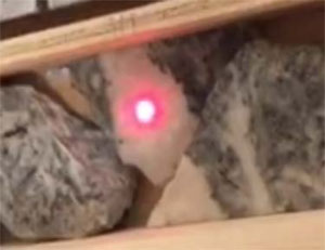
| Project No.: 194594 | Page 24-3 | |
| | Technical Report on the Idaho-Maryland Project Grass Valley California, USA |
Figure 24-2: Laser Point on Non-quartz Rock
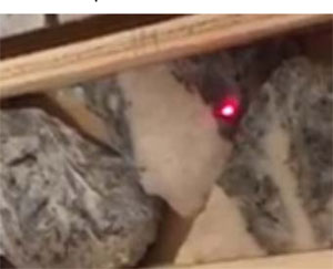
Based on historic records, the required grind size to liberate gold and sulphides appears to be relatively coarse. Historic operators classified their tailings for the Idaho Mine into sand and slime fractions through the use of a cyclone and reported approximately 40% of the tailings as “sand” size. A portion of this sand fraction could potentially be sold offsite for construction which would reduce the mass of tailings to be placed underground.
Available void space would be necessary at any given time during production. The reclaiming of old mining voids, as described earlier in this section, could provide areas of void for new mill tailings to be placed.
| 24.5 | Water Discharge |
Water resources in Nevada County are heavily used and managed by the Nevada Irrigation District (NID). In 2014, the NID estimated that 149,000 acre-ft out of 257,000 ac-ft of total water supply in the County was used as detailed in Table 24-2 and Table 24-3. The NID maintains an extensive network of reservoirs, canals, and pipelines to distribute water to its customers. NID also uses Wolf Creek as a waterway to transfer water between its canals and water distribution system (Brown & Caldwell, 2015).
Evaluation of water discharge locations will be an important aspect of the Project. Groundwater inflow into the mine workings has been estimated at approximately 750GPM or 1,375 ac-ft per year. If the mine is to be dewatered, a higher dewatering rate would be required initially to
| Project No.: 194594 | Page 24-4 | |
| | Technical Report on the Idaho-Maryland Project Grass Valley California, USA |
pump approximately 2,500 ac-ft of water which currently fills the old mine workings (Willdan Associates/PMC, 1995).
Although the water in the mine is quite clean, a robust and effective water treatment plant will very likely be required given the location and intensive use of water resources in the area.
Assuming that water will be treated to achieve any required water quality standards, the most important consideration for discharge of water will be the volume of discharge relative to the location. The South Fork Wolf Creek is most conveniently located next to the Brunswick Shaft and was previously permitted as a discharge point by Emgold in 1995 (Willdan Associates/PMC, 1995). South Fork Wolf Creek however is quite small with low flows and discharge into this creek became a significant concern in the 2008 Emgold EIR study due to the possibility of erosion, suspension of existing solids in the creek bed, and flooding of properties downstream. Some small quantity of water may be required to be discharged into South Fork Wolf Creek as this was proposed as a mitigating factor in the event that dewatering of the mine affected stream flows in SF Wolf Creek (ESA, 2008).
In response to concerns in the 2008 EIR, Emgold determined in their Revised Application to move the discharge point to the main Wolf Creek on the Idaho Land which is a much larger creek and more suitable for the volumes of water contemplated to be dewatered from the mine. They conceptually proposed to run a pipe under E. Bennett Road from the Brunswick Site (ESA, 2008).
Table 24-2: Water Accounting Planning Cycle, Budget Summary, ac-ft (Brown & Caldwell, 2015)
| Planning cycle | ||||||||||||||
| Water Accounting | 1st Year (2011) | 2nd Year (2012) | 3rd Year (2013) | 4th Year (2014) | 5th Year (2015) |
|||||||||
| 1 | Subtotal of Water Supplies | 510,920 | 372,433 | 237,334 | 257.019 | — b | ||||||||
| 2 | Subtotal of Water Uses | 165,281 | 155,671 | 163,214 | 148,975 | — b | ||||||||
| 3 | Drain Water Leaving Service Area | 4,424 | 3,208 | 2,589 | 4,700 | — b | ||||||||
| Water remaining in streams? (non-diverted surface water runoff)* | 341,515 | 213,554 | 71,531 | 103,344 | — b | |||||||||
| a Calculated by subtracting the sum of lines 2 and 3 from line 1. | ||||||||||||||
| b Data not available. | ||||||||||||||
| Project No.: 194594 | Page 24-5 | |
| | Technical Report on the Idaho-Maryland Project Grass Valley California, USA |
Table 24-3: Summary of Water Use, ac-ft (Brown & Caldwell, 2015)
| Planning cycle | ||||||||||||
| Water use | 1st
Year (2011) | 2nd
Year (2012) | 3rd
Year (2013) | 4th
Year (2014) | 5th
Year (2015) |
|||||||
| Agricultural | 111,907 | 108,679 | 113,428 | 109.414 | — a | |||||||
| Environmental | 8,935 | 8,935 | 8,935 | 8,935 | — a | |||||||
| Recreational | 5,433 | 5,433 | 5,433 | 5,297 | — a | |||||||
| Municipal/industrial | 12,225 | 13,227 | 14,224 | 12,129 | — a | |||||||
| Groundwater recharge | 0 | 0 | 0 | 0 | 0 | |||||||
| Transfer and exchange | 12,581 | 6,297 | 7,594 | 0 | 0 | |||||||
| Other | 14,000 | 13,100 | 13,600 | 13,200 | — a | |||||||
| Total | 165,081 | 155,671 | 163,214 | 148,975 | — a | |||||||
| a Data not available. | ||||||||||||
| 24.6 | Reagents |
The mineralization at the I-M mine is amenable to gravity and flotation concentration based on historic reports. The concentrates produced from gravity and flotation circuits will likely be of high value and allow the economic shipment of these products for long distances. It is expected that the use of cyanide onsite would raise significant concerns from citizens in the local area. The shipment of concentrates offsite for further processing would eliminate any need for the use of Cyanide onsite and the only reagents used onsite would be simple and benign flotation regents. Nevada State is in close range of the I-M Mine and has a long history of cyanide use and many established processing facilities. Concentrates could be processed in an owner operated facility or in a third-party facility. The sulphides in the flotation concentrates might also be of use to the autoclave gold processing facilities in Nevada State as they potentially can be useful as fuel for the process used in these operations. If an arrangement could be made for one of these operations to buy the sulphides after the gold has been removed this would be an ideal method to dispose of this material. Alternatively, flotation concentrates could be sold on the international concentrate market which would eliminate any concern in regard to sulphide minerals.
| Project No.: 194594 | Page 24-6 | |
| | Technical Report on the Idaho-Maryland Project Grass Valley California, USA |
| 25.0 | INTERPRETATION AND CONCLUSIONS |
| 25.1 | Geology and Exploration Targets |
Rise compiled a comprehensive archive of historical mine documents including level plans, cross sections, production records, and project reports into a 3D model and used this information to identify several unexplored exploration targets below the current extents of drilling and underground workings. During the targeting process Rise took into consideration known and assumed geological controls on mineralization to delineate zones with potential to host large tonnages of high grade mineralization.
The Idaho Maryland mine is a well-known, prolific high-grade past producing orogenic gold deposit in the Sierra Nevada Foothills of California. Orogenic gold deposits worldwide are associated with regional structural zones and are known to host consistent gold mineralization in quartz-carbonate veins over thousands of feet. In California, the Grass Valley and Mother Lode area deposits host high grade gold in quartz-carbonate veins to vertical depths exceeding 5,000ft (1,524m) . Workings at the Empire Mine in Grass Valley extend to a vertical depth of 3,500ft (1,067m). Significant production at the Idaho-Maryland Mine, adjacent the Empire Mine, extended to a depth of 2,000ft (610m). Minor production has occurred at 2,700ft (823m) and exploration drifts and access tunnels have been developed to 3,280ft (1,000m).
Exploration drifting in the 1950s on the 2400 level identified the down-dip continuation of the major Eureka- Idaho #1 Vein. Past production from the #1 Vein totaled 935,000oz of gold. No exploration drilling or development below the 2400 has occurred on this structure. This area forms the Idaho #1 Vein exploration target.
The concept of a zone gold-rich quartz veins and quartz stockwork hosted in a zone of intense fracturing of metavolcanics related to the interaction of three significant structures below the extent of current exploration was proposed by Bateman in 1948. Development at the 52Vein/60 Winze area at the 2700 level may represent a shallow portion of this target. This concept has been revived as the Crackle zone exploration target.
An large untested zone of meta-volcanic rocks in the immediate footwall of the 6-3 Fault forms the Brunswick exploration target.
The Idaho #1 Vein target may be a down-dip extension of the high-grade Eureka-Idaho zone above. This target has potential to host gold mineralization in a narrow quartz vein similar to that mined at above. The Crackle Zone has potential to host gold mineralization is a broad possibly shallow-dipping zone that may be amenable to bulk-tonnage underground mining
| Project No.: 194594 | Page 25-1 | |
| | Technical Report on the Idaho-Maryland Project Grass Valley California, USA |
methods. The Brunswick target has potential to host narrow sub vertical veins and intersecting flat lying veins that may also be amenable to bulk mining methods.
Each of these targets is substantial in size and warrant exploration drilling. Diamond drilling from surface is recommended as the mine is currently flooded. Acquiring permits to dewater the mine is possible but the time required to apply and grant the permit and the time to dewater and repair workings would be considerable.
| 25.2 | Agreements, Mineral Tenure, Surface Rights, Royalties, Permitting and Liabilities |
Rise Gold Corp holds a 100% interest of surface and mineral rights, with no known encumbrances, of the Idaho-Maryland Mine Property. Rise holds an option to purchase an addition package of surface rights, the Mill Site Property. The existing surface rights are sufficient to allow exploration by drilling from surface.
The Brunswick land package, held as fee simple land, is currently classed “M1” Light Industrial Zone. Exploration diamond drilling on M1 – Industrial Land is an allowed use and does not require a discretionary permit provided that no water is discharged offsite and disturbance per site is less than 1 acre and 1,000yd3 material.
Rise is not aware of any significant liabilities on the Idaho-Maryland Mine Property. A Draft Preliminary Endangerment Report was completed on the Idaho land. The presence of slightly elevated levels of Arsenic on the Idaho land, as a result of historic mine tailings and waste berms, does not currently pose a significant risk to public health or the environment in its current state (Geocon, 2016). A Phase I Environmental Site Assessment was completed on the Brunswick land. The report concluded that there were no current recognized environmental conditions (RECs) on the Brunswick land (ERRG, 2007). A Phase II Environmental Site Assessment was completed on the Mill Site land. As a result of historic operations, elevated arsenic levels are present in the mine waste rock on the property and residual VOC contamination is present in ground water samples from the site. The evaluation concluded that there is no threat to human health from vapor (Geomatrix, 2006). The Mill Site land has a deed restriction which restricts the use of groundwater and construction of wells for extracting water.
| Project No.: 194594 | Page 25-2 | |
| | Technical Report on the Idaho-Maryland Project Grass Valley California, USA |
| 26.0 | RECOMMENDATIONS |
The I-M Project hosts numerous exploration targets that warrant drilling. While a significant drill program is required to test these targets, Rise requested Amec Foster Wheeler prepare a recommended drill program not to exceed $600k.
A single 6,000ft (1,830m) surface diamond drill hole is recommended to provide geological samples from most of the major lithological units on the I-M mine geology. The single hole has been designed to pierce the #1 Vein projection approximately 400ft (122m) below the elevation of the I2400 Level and then carry on through the potential western extensions of the Idaho 3 Vein System. The objectives of this drill hole are as follows:
| 1) | Provide a long drill intercept of the Brunswick Block from surface to the Serpentinite contact. |
| 2) | Test the up-dip area and below the 52 Vein (60 Winze) mineralized area in the Brunswick Block. |
| 3) | Test the #1 Vein below the I2400 Level. |
| 4) | Test the serpentinite footwall for potential 3 Vein/Rose Garden analogies. |
| 5) | Test and obtain samples of ankerite alteration in the serpentinite unit. |
| 6) | Test for the location of the major Idaho faults. |
| 7) | Drill through the serpentinite unit to provide further insight on the thickness and geometry of this unit at depth. |
| 8) | Determine drill hole deviation, drilling productivity, and drilling costs to allow refinement of the design of a major drill program at the I-M Project. |
In addition, Amec Foster Wheeler recommends that the digital geological model be expanded to include model channel samples, the lithological contacts and structures such as the diabase dikes, ankerite alteration envelopes, minor quartz veins, and all faults mapped by the historic mine operators. This work may provide additional insight into the mineralization controls at the I-M Mine.
The cost of the work program is estimated at a cost of $595,000 as show in Table 26-1. The planned drill hole is displayed in Figure 26-1 (plan view) and Figure 26-2 (section view).
| Project No.: 194594 | Page 26-1 | |
| | Technical Report on the Idaho-Maryland Project Grass Valley California, USA |
Table 26-1: Estimated Cost of Recommended Work Program
| Hole Length (m) | 1829 | m | |||
| Duration | 38 | days | |||
| Drilling Cost | $390,000 | ||||
| Mobilization | $7,000 | ||||
| Standby charges | $40,000 | ||||
| Centrifuge System | $36,000 | ||||
| Living Allowance | $29,000 | ||||
| Geology & Assaying | $38,000 | ||||
| Supplies | $15,000 | ||||
| Total Drilling Cost | $555,000 | =$303/m | |||
| Geological Modelling | $40,000 | ||||
| Total Work Program | $595,000 | CAD |
| Project No.: 194594 | Page 26-2 | |
| | |
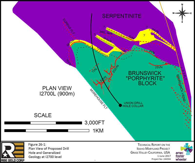
| Page 26-3 |
| | |
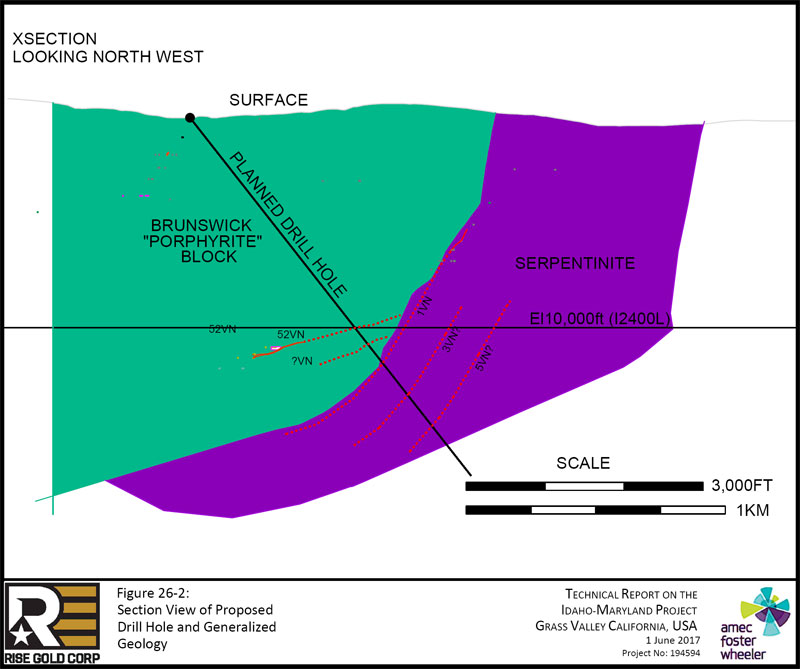
| Page 26-4 |
| | Technical Report on the Idaho-Maryland Project Grass Valley California, USA |
| 27.0 | REFERENCES |
AMEC Americas Limited (AMEC). Preliminary Assessment Technical Report – Idaho-Maryland Mine Grass Valley, California. November 2004.
AMEC E&C Services Limited (AMEC). Idaho-Maryland Mine Technical Report. November 2002.
AMEC Earth & Environmental, Inc. (AMEC). Air Quality Existing and Projected Air Emissions from the Proposed Action Draft EIR. March 2008.
American Society for Testing Materials (ASTM). (2013). ASTM E1527-13, Standard Practice for Environmental Site Assessments: Phase 1 Environmental Site Assessment Process. ASTM International, West Conshohocken, PA. Retrieved at http://www.astm.org/cgi-bin/resolver.cgi?E1527-13
Ash, Chris and Alldrick, Dani. Au-quartz Veins, in Selected British Columbia Mineral Deposit Profiles, Volume 2 - Metallic Deposits, Lefebure, D.V. and Hõy, T., Editors, British Columbia Ministry of Employment and Investment, Open File 1996-13, pages 53-56. 1996.
Ash, Chris. (June 2001). Bulletin 108: Relationship Between Ophiolites and Gold-Quartz Veins in the North American Cordillera. Chapter 8. Geological Survey Branch. Victoria, BC. Retrieved at http://www.empr.gov.bc.ca/Mining/Geoscience/PublicationsCatalogue/BulletinInformation/Bulle tinsAfter1940/Pages/Bulletin108.aspx
Bateman, A.M. Report on Geology and Structure of Idaho-Maryland Mine Grass Valley, California. 1948.
Berger, B.R. Descriptive Model of Low-sulphide Au-Quartz Veins; in Mineral Deposit Models, Cox, D.P. and Singer, D.A., Editors, U.S. Geological Survey, Bulletin 1693, pages 239-243. 1986.
Brown & Caldwell. 2015 Agricultural Water Management Plan, Prepared for Nevada Irrigation District. Rancho Cordova, CA. January 2016.
California Department of Conservation (CDC). (April 2017). SMARA Mines – AB 3098 List, Listing as of April 7, 2017). Retrieved at http://www.conservation.ca.gov/dmr/SMARA%20Mines/ab_3098_list/Pages/Index.aspx
California Energy Commission (CEC). California Climate Zone Descriptions for New Buildings. Sacramento, CA. July 1995.
California Geological Survey (CGS). California Geomorphic Provinces – Note 36. December 2002.
California Geological Survey, Department of Conservation (CGS-DOC). Aggregate Sustainability in California. Sacramento, CA. 2012.
Cal. Pub. Res. Code (CPRC). California Public Resources Code. Chapter 9 – Surface Mining and Reclamation Act of 1975. 1975.
Cal. Pub. Res. Code (CPRC). California Public Resources Code. Division 13 – Environmental Quality. 1979.
| Project No.: 194594 | Page 27-1 | |
| | Technical Report on the Idaho-Maryland Project Grass Valley California, USA |
California Environmental Quality Act (CEQA). (February 1992). City of Sacramento v. State Water Resources Control Board. Retrieved at http://resources.ca.gov/ceqa/cases/1992/sac_swrcb.html
City of Grass Valley Community Development Dept. (CoGV-CDD). City of Grass Valley 2020 General Plan Map. Grass Valley, CA. November 2009.
Clark, Jack. Gold In Quartz – The Legendary Idaho Maryland Mine. Grass Valley, CA. 2005.
Engineering/Remediation Resources Group, Inc. (ERRG). Phase 1 Environmental Site Assessment Round-Hole and New Brunswick Mine Sites. Concord, CA. March 2007.
ESA. Draft Idaho-Maryland Mine Project – Environmental Impact Report. San Francisco, CA. October 2008.
Geocon Consultants, Inc. (Geocon). Draft Preliminary Endangerment Assessment Report. Rancho Cordova, CA. August 2016.
Geomatrix Consultants Inc. (Geomatrix). Summary – Phase II Investigation: Data Collection and Analysis, Brunswick Lumber Mill Site Nevada County, CA. September 2006.
Groves, D.I., Goldfarb, R.J., Gebre-Mariam, M., Hagemann, S.G., Robert, F. Orogenic gold deposits: A proposed classification in the context of their crustal distribution and relationship to other gold deposit types. Ore Geol. Rev. Special Issue, 13, 7-27. 1998.
Hulin, C. Geology and Ore Occurrence of the Idaho Maryland Mine Nevada County, California. 1951.
Idaho-Maryland Mining Corporation (IMMC). Idaho-Maryland Mine Project Grass Valley, California – Section 1.0 2011 Revised Project Description. May 2011.
Johnston, W.D. The Gold Quartz Veins of Grass Valley, California. United States Geological Survey – Professional Paper 194. Washington, D.C. 1940.
Kleinschmidt. City of Grass Valley Sphere of Influence Plan. Prepared for Nevada Local Agency Formation Commission (LAFCo). April 2011.
Koschmann, A. H. and Bergendahl, M. H. Principal Gold Producing Districts of the United States. Geological Survey Professional Paper 610. Washington, D.C. 1968.
Lindgren, W. US Geological Survey Grass Valley Special Map. 1894.
National Oceanic and Atmospheric Administration (NOAA). (April 2017). 1981-2010 Climate Normals – Grass Valley Number 2, CA US. Retrieved from https://www.ncdc.noaa.gov/cdo-web/datatools/normals
Nevada County Board of Supervisors (NC-BOS). Nevada County General Plan – Chapter 9: Noise Element. Nevada County. 2014.
Nevada County Code (NCC). (March 2017). Article 3 Specific Land Uses. Retrieved from http://qcode.us/codes/nevadacounty/?view=desktop&topic=3-ii-2-l__2
| Project No.: 194594 | Page 27-2 | |
| | Technical Report on the Idaho-Maryland Project Grass Valley California, USA |
Nevada County Transportation Commission (NCTC). (May 2015). Brunswick Road / Loma Rica Drive Intesection Improvement Project. Retrieved at http://www.nctc.ca.gov/documents/Projects/Brunswick-Loma%20Rica%20Drive%20Improvement%20Project%20Report%20May%202015.pdf
Pease, Robert C. Idaho-Maryland Mine Project, Grass Valley CA Technical Report. December 2009.
Pehraon, E.W. & Needham for United States Bureau of Mines. Minerals Yearbook 1942. Pg. 288. Washington, D.C. 1943. Retrieved at http://digital.library.wisc.edu/1711.dl/EcoNatRes.MinYB1942
Sohlberg, R.G. Microscopic Study and Determination of Rock Specimens from the Idaho Maryland_Brunswick and Neighboring Mines. 1936.
Shore, F.M for United States Bureau of Mines. Mineral Yearbook 1941. Pg. 252. Washington, D.C. 1943. Retrieved at http://digital.library.wisc.edu/1711.dl/EcoNatRes.MinYB1941
Sillitoe, R.H. Major gold deposits and belts in the North and South American Cordillera: Distribution, tectonomagmatic settings, and metallogenic considerations: Economic Geology, v. 103, p. 663–687. 2008.
Snow, C.A. and Scherr H. Terranes of the Western Sierra Nevada Foothills Metamorphic Belt, California: A Critical Review in International Geology Review, Vol. 48, 2006, p. 46–62. 2006.
State of California – Department of Transportation (DOT). 2015 Traffic Volumes on the California State Highway System. Sacramento, CA. 2015.
Taylor R.D., Goldfarb R.J. Monecke, T., Fletcher, I.R., Cosca, M.A., and Kelly, N.M. Application of U-Th-Pb Phosphate Geochronology to Young Orogenic Gold Deposits: New Age Constraints on the Formation of the Grass Valley Gold District, Sierra Nevada Foothills Province, California In Economic Geology, v. 110, pp. 1313–1337. 2015.
Tolman, G.F. Incomplete Copy Idaho Maryland-Brunswick Development Report 1936-1937. 1937.
United States Department of Agriculture (USDA). (April 2017). CALVEG Mapping Zones. Retrieved at https://www.fs.usda.gov/detail/r5/landmanagement/resourcemanagement/?cid=stelprdb534719 2
Willdan Associates/PMC. Draft Environmental Impact Report for the Idaho-Maryland Gold Mine Dewatering and Exploration Project. Sacramento, CA. May 1995.
Wilkerson G, Lawler D. Roadside Geology and Mining History of the Mother Lode 2008 Part 3: Grass valley to Walker Basin Plumas Copper Belt. 2008.
| Project No.: 194594 | Page 27-3 | |
| | Technical Report on the Idaho-Maryland Project Grass Valley California, USA |
| 28.0 | QUALIFED PERSON CERTIFICATE |
This is to certify that I, Gregory Kenneth Kulla, P.Geo., am employed as a Principal Geologist with Amec Foster Wheeler Americas Limited located at 111 Dunsmuir St., Vancouver, BC, V6B 5W3 Canada.
This certificate applies to the technical report titled “TECHNICAL REPORT ON THE IDAHO-MARYLAND PROJECT GRASS VALLEY CALIFORNIA, USA” that has an effective date of 1 June, 2017 (the “Technical Report”).
| ● | I am a member of the Association of Professional Engineers and Geoscientists of British Columbia. I graduated from the University of British Columbia with a Bachelor of Science in Geology degree in 1988. |
| ● | I have practiced my profession continuously since 1988 and have been involved in exploration, interpretation, geological modelling, and deposit evaluation of precious and base metal deposit assessments in Canada, United States, Australia, Mexico, Chile, Peru, and India, these include orogenic gold deposits. |
| ● | As a result of my experience and qualifications, I am a “qualified person” for purposes of National Instrument 43–101 Standards of Disclosure for Mineral Projects (NI 43–101). |
| ● | I visited the Idaho-Maryland Mine Property on the 29th of March 2017. |
| ● | I am responsible for preparation of all sections of the Technical Report. |
| ● | I am independent of Rise Gold Corp as Independence is described in Section 1.5 of NI 43–101. |
| ● | I have read NI 43–101 and the Technical Report has been prepared in compliance with that Instrument. |
| ● | At the effective date of the Technical Report, to the best of my knowledge, information and belief, the parts of the Technical Report that I am responsible for contain all scientific and technical information that is required to be disclosed to make the Technical Report not misleading. |
Signed and dated this 1 June, 2017.
“signed and sealed”
Gregory Kenneth Kulla, P.Geo.
| Project No.: 194594 | Page 28-1 | |