Attached files
| file | filename |
|---|---|
| 8-K - DUTCH GOLD RESOURCES 8-K 1-29-2010 - Dutch Gold Resources Inc | form8k.htm |
Exhibit
99.1
National
Instrument 43-101
Basin
Gulch Gold Property
Independent
Third-Party Evaluation
Granite
County, Montana
JANUARY
15, 2010
Prepared
For:
|
Dutch
Gold Resources, Inc.
3500
Lenox Road
Atlanta,
Georgia 30326
|
Prepared
by:
OFFICE 360-823-0916 FAX 360-823-0918
EMAIL
dbrown@dbrown-assoc.com
PO Box
87938 Vancouver, WA 98687
| /s/ David E. Brown, RG | |
|
David
E. Brown, RG
|
|
|
Principal
|
|
|
 |
TABLE
OF CONTENTS
| Section |
Page
|
|||
|
EXECUTIVE
SUMMARY
|
iii
|
|||
|
1.0
|
INTRODUCTION
AND TERMS OF REFERENCE
|
1
|
||
|
1.1
|
Introduction
|
1
|
||
|
1.2
|
Terms
of Reference
|
3
|
||
|
1.3
|
Sources
of Information
|
3
|
||
|
1.4
|
Units
and Currency
|
5
|
||
|
1.5
|
Disclaimer
|
5
|
||
|
2.0
|
SITE
DESCRIPTION
|
7
|
||
|
2.1
|
Description
|
7
|
||
|
2.2
|
Accessibility
|
9
|
||
|
2.3
|
Land
Use
|
10
|
||
|
2.4
|
Permitting
Status
|
12
|
||
|
3.0
|
MINE
HISTORY
|
13
|
||
|
3.1
|
Pre-1980s
|
13
|
||
|
3.2
|
1987-1993
|
13
|
||
|
3.3
|
1993
to 1997
|
17
|
||
|
3.4
|
1997
to Present
|
21
|
||
|
4.0
|
GEOLOGY
AND MINERALOGY
|
23
|
||
|
4.1
|
Regional
Geologic Setting
|
23
|
||
|
4.2
|
Basin
Gulch Geologic Setting
|
24
|
||
|
4.2.1
|
General
|
24
|
||
|
4.2.2
|
Structural
Geology
|
32
|
||
|
4.3
|
Mineral
Deposits
|
33
|
||
|
4.3.1
|
General
|
33
|
||
|
4.3.2
|
Ore
Mineralogy
|
36
|
||
|
5.0
|
ORE
ANALYSIS AND VOLUME ESTIMATES
|
38
|
||
|
5.1
|
Sampling
Method and Approach
|
38
|
||
|
5.2
|
Data
Validation and Sample Security
|
39
|
||
|
5.3
|
Metallurgical
Testing and Mineral Processing
|
40
|
||
|
5.3.1
|
Metallurgical
Testing
|
40
|
||
|
5.3.2
|
Mineral
Processing
|
45
|
||
|
5.4
|
2006
Mineral Reserve Estimates Blocks A and B
|
46
|
||
|
5.4.1
|
General
|
46
|
||
|
5.4.2
|
Methodology
and Results
|
46
|
||
|
5.5
|
1996
GEMCOM Mineral Reserve Estimates
|
48
|
||
|
5.5.1
|
General
|
48
|
||
|
5.5.2
|
Methodology
and Results
|
48
|
||
Dutch
Gold Resources, Inc.
Basin
Gulch Gold Prospect
Independent
Third Party Evaluation
i
|
|
|
|
6.0
|
INTERPRETATIONS
AND RECOMMENDATIONS
|
52
|
||
|
6.1
|
Interpretations
|
52
|
||
|
6.2
|
Further
Work
|
53
|
||
|
6.2.1
|
Exploration
|
53
|
||
|
6.2.2
|
Test
Mining
|
54
|
||
|
7.0
|
REFERENCES
|
55
|
||
|
Certificate
of Qualifications
|
58
|
|||
|
Consent
Form
|
59
|
|||
______________________________________________________
FIGURES
|
TITLE
|
PAGE
|
|
|
Figure
1:
|
Project
Location
|
1
|
|
Figure
2:
|
Claims
Location Map
|
9
|
|
Figure
3:
|
Aerial
Photograph (Date Unknown)
|
11
|
|
Figure
4:
|
Drill
Hole Locations
|
14
|
|
Figure
5:
|
Soil
Geochemistry
|
16
|
|
Figure
6:
|
Block
A and Block B
|
18
|
|
Figure
7:
|
Representative
CSAMT Section Through the BG Diatreme
|
19
|
|
Figure
8:
|
Diatreme
Cross-Section
|
27
|
|
Figure
9:
|
Geologic
Map
|
30
|
|
Figure
10:
|
Summary
of Au Recovery Vs Time for Column Leach Test
|
44
|
|
Figure
11:
|
Plot
of Time Vs Au Recovery 70- to 75-foot Interval of Drill Hole
94-70rc
|
45
|
|
Figure
12:
|
GEMCOM
and DBA Polygon Locations
|
49
|
TABLES
|
Table
1:
|
KCA
Head Assay Results
|
41
|
|
Table
2:
|
KCA
Summary of Cyanide Bottle Roll Test
|
42
|
|
Table
3:
|
KCA
Metal Recoveries
|
43
|
|
Table
4:
|
Ore
Volumes From Drilling Results, Block A
|
47
|
|
Table
5:
|
Ore
Volumes From Drilling Results, Block B
|
48
|
|
Table
6:
|
GEMCOM
Computer Modeling Results
|
50
|
Dutch
Gold Resources, Inc.
Basin
Gulch Gold Prospect
Independent
Third Party Evaluation
ii
|
|
|
EXECUTIVE
SUMMARY
This NI
43-101, Independent Third-Party Evaluation, commissioned by Dutch Gold
Resources, Inc., is for the Basin Gulch project, which is an advanced
exploration and test mining gold porphyry project in Montana. The
project consists of eleven patented mining claims, totaling about 217.9 acres;
and an additional 50 unpatented mining claims totaling approximately 1,000
acres, all surrounded by the Deer Lodge National Forest. The claims
are located at the head of Basin Gulch, Quartz Gulch, and Cornish Gulch on the
northern slopes of the West Fork Buttes, within the Sapphire Range of the
Western Montana Rocky Mountains. The property is about 19 road miles
west of the town of Philipsburg, Montana, within the Rock Creek Mining District
of Granite County. The patented property is owned by the Metesh
Family of Phillipsburg, and is under lease agreements to Dutch Gold Resources,
Inc. The unpatented claims have been staked by, and are under control
of, Dutch Gold Resources, Inc. The Basin Gulch area is historically a
placer mining area lacking an historical association with an operating lode
mine. The local placers have been operated since before the turn of
the 20th
century, and continue today.
The lode
mineralization at the head of Basin Gulch is associated with a series of gaseous
Eocene silicic intrusives that invaded between the plates of two Precambrian
thrust sheets of the Belt Super Group. The intrusives formed a major
diatreme complex that is centered on the gold and silver
mineralization. The intrusive event also formed a number of smaller,
parasitic diatremes scattered throughout the property and off the property for
several miles in all directions. The gold mineralization is found
throughout the site near the surface, and at depths in excess of 1,000 feet at
levels averaging between 0.012 and 0.026 ounces per ton, with the high grade
zones associated with the edges of the various diatremes and post- and
pre-diatreme faulting that cut the diatremes. The high grade zones
appear associated with voids formed within the diatreme when juvenile and
surrounding bedrock material fell back into the diatreme throat during periods
of quiescence, and within voids in the surrounding shattered
bedrock. This association with voids and faulting has been recognized
at other gold sites and is well described in the literature. The
results of a CSAMT study indicate the mineralized diatreme complex extends to
below the geophysical study datum of 1,500 feet. However, the site
has only been drilled to a depth of just over 1,000 feet, well above the boiling
point level in the diatreme.
Dutch
Gold Resources, Inc.
Basin
Gulch Gold Prospect
Independent
Third Party Evaluation
iii
|
|
|
The ore
itself is fairly simple and not associated with significant sulfide
mineralization. The gold encountered so far in the drill holes is
free in nature, being fine to very coarse, and easily extracted using
cyanidation. Test beneficiation work done for Cable Mountain Mine
indicates a recovery rate of perhaps over 95% with a simple cross-current
cyanidation mill. Other potentially acceptable recovery methods are
also being considered.
Cable Mountain Mine Inc., who
discovered the Basin Gulch deposit in 1987, explored the lode source of the
placer gold from the late 1980s until 1997. To date, 323 reverse
circulation and core holes have been drilled on the property for a total of
89,800 feet, with holes ranging from 80 feet to 1,045 feet in
depth. In addition, 40 test trenches with a total length of 17,000
feet have been excavated and sampled. Cable Mountain Mine, Inc.,
Chevron Resources, and Cyprus Exploration have performed the work at various
stages in the project. All of this work was supervised or reviewed by
Dutch Gold Resources President, Rauno Perttu, which provides a continuity of the
work performed. In addition to the drilling, there have been two
geophysical surveys, a soil geochemistry survey, topographic surveys, geologic
mapping, and pre-development biological, cultural and hydrological studies
completed on the property.
Two high
grade targets, termed Ore Block A and Ore Block B, were blocked out in a 2006 NI
43-101 prepared by David Brown & Associates, based on a portion of the
property with a high density of drilling. They are both located on
the edges of the major diatreme complex at the head of Basin
Gulch. David Brown & Associates, using a very simple averaging
technique based on the numerous drill hole assays, yielded a total of 341,000
ounces of gold for combined Probable and Proven gold for the Ore Reserves in
Blocks A and B only. This
study did not include gold-equivalent silver, which occurs at an approximate
ratio of about 20 ounces of silver for every ounce of gold.
A
previous study, commissioned in 1996 by Cable Mountain Mine performed by GEMCOM
of Reno, Nevada yielded a combined volume of Proven and Probable gold and
gold-equivalent silver ranging from 2,803,970 ounces Au with an average grade of
0.026 ounces per ton to 7,600,000 ounces Au with an average grade of 0.012
ounces per ton Au. Cutoff grade in all cases was 0.005 ounces per ton
Au. The work by GEMCOM was preliminary in nature, was never
formalized beyond the draft stage, only included about one third of all the
drill holes on the site, and did not make a distinction between the two grades
of resource. The drill holes that were not included in the GEMCOM
study were all of the holes drilled by Cable Mountain in late 1996 and all of
1997. Because all of the drill holes and drill hole assays were not
used for these calculations, and both estimates are open in all directions,
these volume estimates should be viewed as an approximate low end of the total
gold present on the site.
Dutch
Gold Resources, Inc.
Basin
Gulch Gold Prospect
Independent
Third Party Evaluation
iv
|
|
|
Based on
the results of this third-party evaluation, several recommendation are made to
complete field evaluation of this advanced exploration project. The
following are those basic elements.
|
|
q
|
Complete
a detailed 3D CSAMT study that incorporates the results of the earlier
work, which was very effective in identifying the mineralized
diatremes. Extend this study to a depth of at least several
thousand feet and a mile or more in all directions. Use the
results of this study for efficient location of the proposed drill
holes.
|
|
|
q
|
Complete
drilling and sampling of the two high grade zones with diamond core
drilling to give an adequate evaluation of potential ore
volumes.
|
|
|
q
|
Complete
several core holes in the areas of one and two-point anomalies that were
encountered during the previous exploration
efforts.
|
|
|
q
|
Perform
an updated probabilistic model of the gold volume on the site to help
assess new drill targets and high grade
zones.
|
|
|
q
|
Perform
test underground mining in the two high grade targets after completion of
the drilling recommended above.
|
Dutch
Gold Resources, Inc.
Basin
Gulch Gold Prospect
Independent
Third Party Evaluation
v
|
|
|
|
|
q
|
Evaluate
the open pit potential of the property utilizing non-cyanide recovery
techniques.
|
|
|
q
|
Re-start
definition of biological and hydrological baselines that was begun in the
1990s, leading to production permitting. This should occur at
the same time as the exploration is being
done.
|
Dutch
Gold Resources, Inc.
Basin
Gulch Gold Prospect
Independent
Third Party Evaluation
vi
|
|
|
1.0
INTRODUCTION
AND
TERMS
OF REFERENCE
|
1.1
|
INTRODUCTION
|
Dutch
Gold Resources, Inc. (Dutch) of Atlanta, Georgia has acquired Aultra Gold, Inc
(Aultra) of Jacksonville, Oregon, through a Stock Transfer
Agreement. Aultra will now function as a wholly-owned subsidiary of
Dutch. Aultra previously had obtained the mining rights to the Basin
Gulch patented mining property (Figure 1 and Figure 2) through a Royalty
Agreement with the Metesh family of Philipsburg, Montana. The
Agreement calls for a $50,000 minimum annual royalty payment to the Metesh
Family, who also retains surface rights to the property and a capped 2% Net
Smelter Royalty.

Figure
1: Project Location
Dutch
Gold Resources, Inc.
Basin
Gulch Gold Prospect
Independent
Third Party Evaluation
1
|
|
|
Dutch now
controls the entire Basin Gulch property from Eureka Gulch, south to the head of
Basin Gulch, including several high-grade gold targets, which were the subject
of a two previous NI 43-101 evaluations1,2. In
addition, in late 2009, Aultra re-staked an additional 50 unpatented claims (Figure 2), surrounding
the Metesh group of claims.
A
National Instrument 43-101 prepared in 2006 by David Brown & Associates
focused on two high grade targets at the head of Basin Gulch. The
second National Instrument 43-101 prepared in 2009 by David Brown &
Associates focused on the high grade targets plus it incorporated
the work performed by GEMCOM in 1996. This latest 2010 NI 43-101
document updates ownership, claims position and exploration strategy for the
entire Basin Gulch property.
The Basin
Gulch area has historically been mined by traditional placer methods, including
hydraulic mining since the early part of the last century. The
remains of this mining activity still exist on the site3 in the form of
collapsed short portals, excavations, tailings piles, mine ponds, remains of log
cabins and out buildings, log and dirt dams, and hydraulic diversion
structures. Information reviewed for this report, such as a yearly
report from 19154,
and historic descriptions by the State of Montana5, indicates, while
placer mining was active in the gulch, only modest production was
realized. The work does, however, include hints of lode
mineralization in the Basin Gulch area that was never exploited to any
extent. During the DBA 2009 site visit, an active small placer
operation at the head of Basin Gulch was observed. During the 1990s a
large, active placer operation was also worked on adjacent Quartz Gulch6 (Figure
1).
Cable
Mountain Mine Inc. (CMM), who discovered the Basin Gulch deposit, explored the
lode source of the placer gold from the late 1980s until 1997. To
date, 323 reverse circulation and core holes have been drilled on the property
for a total of 89,800 feet, with the holes ranging from 80 feet to 1,050 feet in
depth. In addition, 40 test trenches with a total length of 17,000
feet have been excavated and sampled7. Cable
Mountain Mine, Inc., Chevron Resources, and Cyprus Exploration have performed
the work. In addition to the drilling, there have been two
geophysical surveys, soil geochemistry surveys, topographic surveys, geologic
mapping, and pre-development biological, cultural and hydrological studies
carried out on the property. A probabilistic GEMCOM computer model of
the mineralization aimed at open-pit development was generated in
1996. These studies, in whole, or in part, were reviewed in
preparation of this report.
|
1
|
David Brown
& Associates, 2006, Preliminary Draft Report
National Instrument 43-101F Basin Gulch Gold Property Independent
Third-Party Evaluation Granite County, Montana: Third-party
evaluation prepared for Dutch Mining, Ltd,
46p.
|
|
2
|
David Brown & Associates,
2009, National Instrument 43-101 Basin Gulch Gold Property
Independent Third-Party Evaluation Granite County,
Montana: Third-party evaluation prepared for Aultra Gold, Inc.,
53p.
|
|
3
|
GCM Services, Inc.,
1996, Cultural Resources Inventory and Evaluation: 1,080
Acres on Cornish and Basin Gulches Granite County,
Montana: Consulting Report to Cable Mountain Mine, Inc,
68p.
|
|
4
|
Berry, F.J., 1915,
Letter report to the Basin Mining Company of St. Louis, Missouri on Yearly
Exploration and Development Activities: 4
p.
|
|
5
|
www.DEQ.mt.gov/AbandonedMines.
|
|
6
|
Perttu, Rauno, 2006,
Personal Communication and Photo
Archives.
|
|
7
|
Perttu, Rauno,
1996,
Ibid.
|
Dutch
Gold Resources, Inc.
Basin
Gulch Gold Prospect
Independent
Third Party Evaluation
2
|
|
|
The Basin
Gulch Project is an advanced stage exploration project with a substantial
investment already made in previous exploration work on the
property. However, no mining has yet taken place on the site, beyond
the placer and very limited lode operations, for which no detailed records
exist.
Dutch has
proposed as a next step to undertake an extensive drilling and sampling program
that will coincide with focused underground test development and production
programs. The drilling will be aimed at deeper zones within the
diatreme complex and open-pit development and the underground work will be aimed
primarily at test mining the high-grade gold zones identified in the 2006 and
2009 NI 43-1018
studies.
|
1.2
|
TERMS
OF REFERENCE
|
David Brown & Associates
(DBA) was retained by Dutch to perform an independent third-party
compilation and review of all available data, both public and proprietary, and
to prepare this summary of the geology and mineral potential and a description
of the proposed advanced exploration and test mining program at the Basin Gulch
property in Granite County, Montana. A number of consultants,
exploration companies, and Federal and State of Montana Agencies, other than
DBA, prepared the geological and mineralogical models of Basin Gulch presented
herein. This document follows the guidelines set out under National
Instrument 43-101 following form 43-101F1. This report is to be used
by Dutch as an independent third-party evaluation to support future financing
for the exploration and development program.
|
1.3
|
SOURCES
OF INFORMATION
|
Geotechnical
studies have been carried out on the Basin Gulch Mine property over the last 20
years or so by a number of private and public investigators. A number
of publicly-available reports have been produced by the Montana Bureau of Mines
and Geology (MBMG) and the US Geological Survey (USGS) on the general geology of
the area. A complete list of resources reviewed and data used are
included in Section 7.0 References of this report. Most of those data
were available for inspection at Dutch offices in Jacksonville, Oregon by DBA in
preparation of this NI 43-101. They include:
|
|
q
|
Several
yearly progress reports to Cable Mountain Mine, Inc. on exploration
activities at Basin Gulch from the 1990s, authored by Rauno
Perttu;
|
|
|
q
|
Two
geophysical reports on the property; including a Controlled Source
Audiomagnetotelluric (CSAMT) survey and a Very Low Frequency (VLF)
survey.
|
|
8
|
David Brown & Associates,
2006, Ibid.
|
Dutch
Gold Resources, Inc.
Basin
Gulch Gold Prospect
Independent
Third Party Evaluation
3
|
|
|
|
|
q
|
Draft
contour maps from a soil geochemistry survey for gold, silver, antimony,
and arsenic performed by Cyprus Mines. The methodologies,
laboratory results, and written report were not available for
review;
|
|
|
q
|
Detailed
geologic mapping by Cyprus Mines and by Rauno Perttu of Cable Mountain
Mine;
|
|
|
q
|
Regional
Geologic mapping by the USGS and the
MBMG;
|
|
|
q
|
Drilling
results from the numerous test holes drilled on the project site,
including a large number of silver and gold assays and geologic
logs;
|
|
|
q
|
A
consultant’s report prepared on the Air Quality of the site in
anticipation of mining in the
mid-1990s.
|
|
|
q
|
A
consultant’s report prepared on the Surface and Groundwater Quality of the
site in anticipation of mining in the
mid-1990s.
|
|
|
q
|
A
consultant’s report prepared on the Cultural Resources of the site in
anticipation of mining in the
mid-1990s.
|
|
|
q
|
A
consultant’s report prepared on the Biological and Wildlife Resources of
the site in anticipation of mining in the
mid-1990s;
|
|
|
q
|
A
consultant’s report prepared on the Aquatic Biological Baseline of the
site in anticipation of mining in the
mid-1990s;
|
|
|
q
|
A
consultant’s report prepared on the Wetlands Resources of the site in
anticipation of mining in the
mid-1990s;
|
|
|
q
|
A
consultant’s report prepared on Soil Heavy Metal Attenuation of the site
in anticipation of mining in the
mid-1990s
|
|
|
q
|
A
consultant’s report prepared on a Metallurgical Test Program for the site
ore in anticipation of mining in the
mid-1990s;
|
|
|
q
|
Aerial
photography, topographic mapping, and claims location maps prepared by a
consulting engineer from Dillon,
Montana;
|
|
|
q
|
A
drill hole and gold assay data base used for generating a GEMCOM computer
model of the Basin Gulch site.
|
|
|
q
|
The
results of a 1997 preliminary probabilistic computer-based model of the
gold volume for an open-pit operation by GEMCOM. The model was
of a portion of the site above the 5,000-foot elevation at the head of
Basin Gulch.
|
Dutch
Gold Resources, Inc.
Basin
Gulch Gold Prospect
Independent
Third Party Evaluation
4
|
|
|
|
|
q
|
Gold
and silver assay laboratory reports from the multiple laboratories used by
Cable Mountain for the Basin Gulch
project.
|
|
|
q
|
Numerous
correspondences, reports, maps, and other documents found in the Basin
Gulch files in the Dutch offices in Jacksonville,
Oregon.
|
|
1.4
|
UNITS
AND CURRENCY
|
Unless
otherwise noted, all units used in this report are as follows.
|
|
Length:
|
English
Units (inch, foot, yard, and mile)
|
|
|
Volume:
|
English
Units (cubic yard = 27 cubic feet)
|
|
|
Weight:
|
English
Units (troy ounce, pound, ton). Tons are in short tons (2,000
pounds)
|
|
|
Ore
Grade:
|
Troy
ounces per short ton (opt) (1 troy ounce = 31.1
grams)
|
|
|
Currency:
|
US
Dollars ($). All values are given in dollars for the year
reported and are not corrected to 2010
dollars.
|
Rock
Density
Density
testing on the Basin Gulch Mine diatreme rock indicates a yield of approximately
3.7 short tons (7,400 pounds) per cubic yard. This can also be
expressed as 12 cubic feet per ton of Bank
Ore9.
Truck Ore
is generally about 1.25 times the size of Bank Ore due to expansion of rock
after excavation. Volumes expressed in this report are all in Bank
Ore.
|
1.5
|
DISCLAIMER
|
David E.
Brown, RG visited the site, for purposes of this independent literature and data
review, on April 27th and
28th,
2006 and then again on May 26th and
27th,
2009. The visits consisted of an inspection of the property on foot,
and by 4-wheel drive vehicle. The surrounding area of Rock Creek,
Stony Gulch, Cornish Gulch, and Quartz Gulch were also inspected, as well as
possible, taking into consideration the limited access created by ownership
interests and road conditions. Lode mining was not actively taking
place in Basin Gulch, but inspection of the area of interest indicted some
fairly recent surface disturbance associated with small-scale placer
operations. Documents were reviewed prior to the 2006 and 2009 visits
in the Aultra offices in Jacksonville, Oregon.
David
Brown & Associates, neither as a company, nor as individuals, has any
monetary interest in the Basin Gulch Mine Project or in Dutch Gold or Aultra
Gold. David Brown & Associates is being paid for this work by
Dutch Gold Resources, Inc.
|
9
|
Bank
Ore is defined as ore in-situ, as found in
the outcrop, before
excavation.
|
Dutch
Gold Resources, Inc.
Basin
Gulch Gold Prospect
Independent
Third Party Evaluation
5
|
|
|
This
report has been prepared by David Brown & Associates using public and
private documents given to the author for this purpose. While
reasonable care has been taken in preparing this report, David Brown &
Associates cannot guarantee the accuracy or completeness of all supporting
documentation. In particular, David Brown & Associates did not
attempt to determine the veracity of geochemical, geophysical, or geological
data reported by third parties, or to conduct duplicate sampling for comparison
with the geochemical results provided by other parties. Only two,
two-day field reconnaissance visits were conducted, and a gross geometric
modeling was made for volumetric ore grade determinations, as presented in the
2006 43-101 report. In addition, a preliminary draft volumetric ore
grade determination was made by a third party in 1996 and presented in the 2009
43-101 report. Consequently, the use of this report shall be at the
user’s sole risk and David Brown & Associates hereby disclaims any and all
liabilities arising out of the use or distribution of this report or reliance by
any party on the data herein. The author’s interpretive views
expressed herein may or may not reflect the views of Dutch or other
investigators.
Dutch
Gold Resources, Inc.
Basin
Gulch Gold Prospect
Independent
Third Party Evaluation
6
|
|
|
2.0
SITE
DESCRIPTION
|
2.1
|
DESCRIPTION
|
The Basin
Gulch prospect area consists of 11 patented mining claims, and 45 non-patented
mining claims, surrounded by Deer Lodge National Forest land and a few patented
mining claims, totaling about 1,200 acres of controlled ground (Figure
2). The prospect claims are all located at the head of Basin Gulch,
Cornish Gulch, and Quartz Gulch, on the northern slopes of the West Fork Buttes,
within the Sapphire Range of Southwestern Montana. A land title
search was not part of this report, nor was a claims validation study
made. However, a study was made by Anderson Engineering of Dillon,
Montana in the mid-1990s of the patented claims. A review of Bureau
of land Management (BLM) records of the unpatented claims was made online by DBA
staff to confirm the location and status of the unpatented claims.
The
property deeds can be viewed at the Granite County Courthouse in Philipsburg,
Montana. The owner of record for the patented claims is:
Ms.
Margery Metesh
P.O. Box
427
Philipsburg,
Montana 59858
The
claims are all located in south-central Granite County, in portions of Section
34, Township 7 North, Range 16 West, and Sections 3, 4, and 9, Township 6 North,
Range 16 West (Figure 2).
The
patented mining claims making up the Basin Gulch Group include the
following:
|
q
|
Landes
|
(Mineral
Survey 5565)
|
|
q
|
Shylock
|
(Mineral
Survey 6354)
|
|
q
|
Shively
|
(Mineral
Survey 5755)
|
|
q
|
Quartz
Hill
|
(Mineral
Survey 5564)
|
|
q
|
Spencerian
|
(Mineral
Survey 8140)
|
|
q
|
Gold
Hill 5
|
(Mineral
Survey 5755)
|
|
q
|
Basin
|
(Mineral
Survey 9026)
|
|
q
|
Blue
Bell Lode
|
(Mineral
Survey 9530)
|
|
q
|
White
Pine
|
(Mineral
Survey 8137)
|
|
q
|
Yellow
Pine
|
(Mineral
Survey 8139)
|
|
q
|
Jack
White
|
(Mineral
Survey 8138)
|
The
unpatented Mining Claims making up the Basin Gulch Group are as
follows.
Dutch
Gold Resources, Inc.
Basin
Gulch Gold Prospect
Independent
Third Party Evaluation
7
|
|
|

Dutch
Gold Resources, Inc.
Basin
Gulch Gold Prospect
Independent
Third Party Evaluation
8
|
|
|
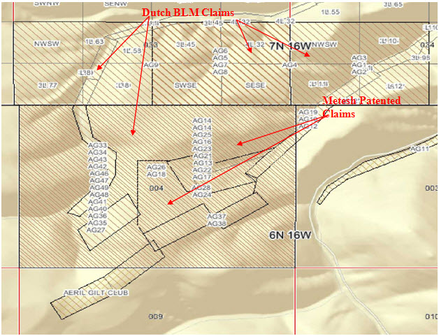
Figure
2: Claims Location Map
|
2.2
|
ACCESSIBILITY
|
The
proposed mine site is located on the upper slopes of the Basin Gulch, Cornish
Gulch and Quartz Gulch drainages. Each drainage supports an
individual creek which flow north into Eureka Gulch and then into Rock Creek
(Figure 1). Access from Philipsburg is west on Rock Creek Road
(Montana State Highway 438) for 15 miles, and then 2.1 miles west on Lower Rock
Creek Road to an unimproved mine access road heading up Basin Gulch toward the
south. The proposed mine site is located an additional two miles up
the mine road from Lower Rock Creek Road.
Rock
Creek Road is a two-lane; asphalt paved State Highway that is open year
round. Lower Rock Creek Road is a graveled road also open year round
to serve the local ranches and homes. The mine access road is an
unimproved track that cannot always be passed during the snowy winter months in
its present condition without plowing.
Dutch
Gold Resources, Inc.
Basin
Gulch Gold Prospect
Independent
Third Party Evaluation
9
|
|
|
Philipsburg
is a mining and tourist town with a population of about 1,000, located at an
elevation of about 5280 feet in the Flint Creek Valley of Western Montana Rocky
Mountains. The County Seat of Granite County, Philipsburg, lies about
26 miles south of Interstate-90, and about 54 road miles northwest of Butte,
Montana, the nearest major city. The closest full service community
is Anaconda, Montana, located 31 miles south of Philipsburg on State Highway
1. The nearest major airport to the project is located in Butte,
Montana, 54 miles southeast on Highway 1. A weather alternative
airport is located 75 road miles away in Missoula, Montana, and a non-commercial
airfield is located just south of Philipsburg on Airport
Road. Highway truck transport services are available in
Philipsburg. There is no longer rail service to
Philipsburg.
The
terrain at the mine site is rugged and steep. According to the
Cornish Gulch USGS Quadrangle map for the Basin Gulch Mine site, elevations
range from between about 4,875 feet MSL at the mouth of Eureka Gulch, on Rock
Creek, up to about 6,400 feet MSL at the proposed mine site (Figure
1). The mountainsides are rocky and mostly talus covered, with slopes
ranging from 35 to 60 percent, along with flatter areas. Lodgepole
Pine and Douglas Fir forests cover the slopes, with a fairly clear understory
and low ground cover.
Although
elevations are moderate, the study area is a north slope location, which means
the climate can be characterized by short, cool summers and long, cold
winters. Average monthly temperatures at the Philipsburg Ranger
Station, with a similar elevation (about 5,270 feet) as Basin Gulch, range
from about 22oF to
23oF in
January to about 61oF to
62oF in
July10. Daily
extremes can be expected to be much more dramatic, ranging from a low of
-36oF in
winter, up to +100oF in
summertime.
Precipitation
in the study area can be expected to vary considerably, depending on
elevation. Upper elevations receive considerably more precipitation,
particularly snowfall during winter, than lower elevations. According
to the USFS, lower elevations receive 13 to 15 inches of precipitation annually,
while upper elevations can receive 50 inches or more. At the time of
the April, 2006 field inspection, there were still un-passable snow banks in the
access road above an elevation of about 6,000 feet in late April. The
site was dry and free of snow during the late May, 2009 field
inspection.
There is
no public power or phone service at the mine site. Radio and cell
phone communications and a diesel generator have been used during exploration
operations.
|
2.3
|
LAND
USE
|
Land
ownership within the project area is in two categories. The center of
the prospect is fee-simple ground owned by the Metesh Family. That
land is surrounded by un-patented mining claims on BLM land, which are all
controlled by Dutch. The surrounding land is primarily US Forest
Service administered public land.
|
10
|
Western Technology and
Engineering, 1996, Basin Gulch Project Wildlife Baseline
Study: Consulting Report Prepared for Cable Mountain Mine,
Inc., 84p.
|
Dutch
Gold Resources, Inc.
Basin
Gulch Gold Prospect
Independent
Third Party Evaluation
10
|
|
|
The lower
elevations near Rock Creek are overwhelmingly private land, and there are a
number of additional privately held patented placer mining claims lying in
Cornish Gulch to the east and in Quartz Gulch to the west (Figure
2).
The lower
elevation land is primarily used for agriculture, with hay farming and livestock
grazing predominating. The public lands are used for livestock
grazing, recreation, timber harvesting, and historic mining. There
has been very little timber harvest recently in the proposed mining area, but
there has been considerable timber harvesting to the east11.

Figure
3: Aerial Photo (date unknown)
|
11
|
Western Technology and
Engineering, 1996, Ibid.
|
Dutch
Gold Resources, Inc.
Basin
Gulch Gold Prospect
Independent
Third Party Evaluation
11
|
|
|
|
2.4
|
PERMITTING
STATUS
|
The
previous exploration permits for the property have lapsed. New
exploration drilling permits are being applied for by Dutch, and the previous
permitting process in the 1990s is expected to streamline the new
permitting.
In
Montana, Federal (BLM) and private lands are handled similarly in the permitting
process. Dutch must apply for either a blanket exploration permit for
Montana, or a specific permit for the Basin Gulch project. In either
case, proposed drill sites and trenches must be located on a map, with a
detailed description of how the preparation and reclamation of each site will be
completed. The regulators will then have the choice of sending out an
inspector to review the proposed plan. The State and perhaps the BLM
will subsequently calculate a reclamation bond amount for the work proposed,
based on existing State standards. Upon Dutch posting the bond, Dutch
may then proceed with the exploration work.
During
work in the 1990s, none of the proposed exploration follow-up sites had any
deleterious aspects that needed mitigating, so no new significant obstacles to
exploration are anticipated.
Regarding
anticipated test mining (Section 6.22 of this Instrument), this work will be
conducted under Small Miner’s Exclusion (SME) provisions of the Montana
permitting process. The SME process is much faster and simpler than
the permitting process for larger mines in Montana, and can be completed within
months of filing of an application.
In 1998,
Citizens Initiative Cl-137 was passed in Montana stating the
following:
“...82-4-390. Cyanide heap and vat
leach open-pit gold and silver mining prohibited. (1) Open-pit mining for
gold or silver using heap leaching or vat leaching with cyanide ore-processing
reagents is prohibited except as described in subsection (2).
(2)
A mine described in this section operating on November 3, 1998, may continue
operating under its existing operating permit or any amended permit that is
necessary for the continued operation of the mine…”
In
essence, using cyanide in either a heap leach or closed circuit/cross current
mill associated with an open-cast mine in Montana is strictly
prohibited. DBA understands that Dutch recognizes this law and will
develop this mine in a way so as to not create a conflict.
Dutch
Gold Resources, Inc.
Basin
Gulch Gold Prospect
Independent
Third Party Evaluation
12
|
|
|
3.0
MINE
HISTORY
|
3.1
|
PRE-1980s
|
Gold
placer mining focused on the upper Rock Creek area from the late 1800s up to the
present. The Basin Creek and Quartz Creek placers are within the Rock
Creek Mining District, as defined by the Abandoned Mine Reclamation Bureau of
the Montana Department of State Lands. Although the Rock Creek
District has seen some gold placers, primarily in Basin and Quartz Creeks, the
upper Rock Creek area is best known for sapphire operations located south of the
divide separating Basin Gulch and Quartz Gulch (which both flow north into Rock
Creek) from Sapphire, Anaconda and Coal Gulches (which flow south into the West
Fork of Rock Creek).
The
sapphire gravels on Sapphire, Anaconda and Coal gulches were first discovered
around 1892 by gold placer miners who worked the area extensively during 1899
and 1900 recovering some 400,000 carats of rough sapphires12.
Basin and
Quartz Creeks have both been intermittently placer mined for gold since
190413. Earlier
efforts may have been more profitable than officially reported, since production
justified putting 14 men to work on the placers in 1903. The placers
had recorded production in 1911, 1914 to 1928, 1934 and
1940. Hydraulic placer operations on Basin Creek in 1922 yielded the
largest annual production valued at $7,000. The source of the gold in
Basin and Quartz creek gravels had not yet been determined, but it was suggested
in 1948 that it probably originated from the intrusive volcanic rocks exposed
near the headwaters of the creek14. The
placer operations in Basin Gulch also reportedly produced significant numbers of
“large” sapphires, as
reported to Dutch by the Metesh family, whose grandfather was a placer operator
who reportedly produced three small kegs of sapphires in addition to
gold.
|
3.2
|
1987
TO 1993
|
In 1987,
Cable Mountain Mine, Inc (CMM) personnel visited the Basin Gulch property, which
was, as described above, an old placer property on the edges of a historic
mining district, but without any associated known lode
mineralization. During the field visits, Rauno Perttu, RG, CMM’s
geologist recognized the lode potential and acquired the property on a simple
lease/option-to-purchase agreement with no retained royalty, staked a large
block of surrounding BLM unpatented claims, and drilled the first two shallow
holes. The first hole, BG-1, was drilled within a suspected
diatreme15 complex
in the upper Basin Gulch drainage which had been placer mined
extensively. The diatreme complex had not yet been completely mapped,
and the 190-foot hole was too shallow where it was located to encounter the main
diatreme complex. The second hole, BG-2, was drilled to a depth of
202 feet on the southwest margin of the diatreme complex, and intersected
significant shallow ore-grade gold and silver mineralization. Because
CMM was active elsewhere, and recognized that Basin Gulch was potentially a very
large project, a business decision was made, and the project was farmed out to
Chevron Resources.
|
12
|
Zeihen, L., 1986,
Sapphire Deposits of Montana: Directory of Montana
Mining Enterprises for 1986, Montana Bureau of Mines and Geology Bulletin
126.
|
|
13
|
Lyden, C.J., 1948, The
Gold Placers of Montana: Montana Bureau of Mines and Geology
Memoir 26, Montana School of Mines,
Butte.
|
|
14
|
Lyden, C.J., 1948, Ibid.
|
Dutch
Gold Resources, Inc.
Basin
Gulch Gold Prospect
Independent
Third Party Evaluation
13
|
|
|

Dutch
Gold Resources, Inc.
Basin
Gulch Gold Prospect
Independent
Third Party Evaluation
14
|
|
|
In early
1992, Chevron Resources subsequently completed a soil geochemical survey over
and locally beyond the placer mined area (Figure 5). The geochemical
survey found several strong soil anomalies, which continued across and beyond
the survey area. Even though data results indicated some of the other
soils anomalies were stronger than the one near the BG-2 discovery area, Chevron
drilled 11 shallow angle reverse-circulation holes in the spring of 1992 within
a small area centered on BG-2, assuming the mineralization was along a
high-grade, high-angle structure or fault zone (Figure 4). Six of the
drill holes encountered shallow ore-grade mineralization. The other
five were completed too shallow and did not intersect ore-grade
mineralization.
Chevron
also completed 13 shallow exploration trenches, several of which intersected
broad zones of gold and silver mineralization. Chevron’s work was
clustered around the CMM discovery hole BG-2 and downhill, on the surface of the
large diatreme complex.
Chevron
Resources work ceased in the summer of 1992 when Chevron’s parent company
dissolved Chevron Minerals Company and terminated their involvement in the
mining industry. Although CMM tried to regain control of the
property, Chevron included the property in a sale package of properties to
Cyprus Exploration.
In late
1992, Cyprus completed 6 additional trenches and 5 additional drill
holes. The longest trench, and all 5 of the drill holes were
completed in a small area in Cornish Gulch, about 4,500 feet to the northeast of
Chevron’s work, in the middle and lower hillside of a ridge on the west side of
Cornish Gulch, which contained ore-grade outcrops within altered shallow igneous
rocks. This area of mineralization appeared to dip gently into the
hillside, and did not extend to the bottom of the hillside. Because
of the steep hillside, and because Cyprus believed the mineralization to be
controlled by a high-angle structure, the Cyprus drill holes were sited on the
lower flank of the hill, below the hillside mineralization. Three of
the drill holes intersected potentially ore-grade mineralization, with the
second, 92BG-C2, a 350-foot vertical hole, bottomed in 85 feet of continuous
gold mineralization.
|
15
|
A Diatreme
is defined as a gas volcano or breccia
pipe.
|
Dutch
Gold Resources, Inc.
Basin
Gulch Gold Prospect
Independent
Third Party Evaluation
15
|
|
|

Figure
5: Soil Geochemistry
Dutch
Gold Resources, Inc.
Basin
Gulch Gold Prospect
Independent
Third Party Evaluation
16
|
|
|
The
longest of the Cyprus trenches along the road below the hillside was dug in
colluvium, and intersected intervals of ore-grade gold mineralization up to 160
feet long. The other Cyprus trenches, which were located in Basin
Gulch, also encountered broad zones of mineralization.
Cyprus
project management expressed a desire to continue the
project. However, new senior management changed the company’s focus
to base metals and, in 1993, CMM regained control of the project.
Neither
Chevron nor Cyprus shared their data with CMM. Therefore, with the
exception of limited Cyprus drilling results, some cursory geologic mapping, and
a soil chemistry survey, no work from this period of exploration was available
for examination during the preparation of this NI 43-101 or the previous
documents prepared in 2009 and 2006.
|
3.3
|
1993
TO 1997
|
CMM
Drilling
From June
of 1993 through the end of 1997, CMM completed an additional 205 drill holes and
40 trenches, mostly south of the main BG diatreme complex. Most of
these drill holes and trenches intersected ore-grade gold and silver
mineralization. This work outlined what is termed the Block A reserve
(Figure 6), which is open in several directions, and verified the existence of
ore-grade mineralization on the hilltop to the south, and in the adjacent major
diatreme complex to the north. Ore grade float and outcrops were also
found in other localities on the property. This work also encountered
the high-grade gold zone along the southeastern edge of the diatreme, which was
the focus of the 2006 43-101.
Although
CMM completed a large amount of work, and significant gold and silver resources
and reserves were established, exploration of the property is still very
incomplete. This is because of the very large size of the mineralized
area discovered, and the inferred depth to which the mineralization
extends. The recognized area of surface mineralization extends across
an area at least 14,000 feet by 8,000 feet, encompassing approximately 2,600
acres. Beyond this 2,600-acre area, geochemical anomalies associated
with favorably altered, shattered quartzites and igneous rocks suggest that the
mineralization extends even farther, to include an area of perhaps 4,500 acres
or more. On an even larger scale, CMM discovered that ore-grade
mineralization occurs along structural zones projecting perhaps several miles
outward from the Basin Gulch mineralized area. Drill holes over 500
to 1,000 feet showed gold mineralization to their total depth, thus inferring
the depth of gold mineralization to be in excess of 1,000 feet or
more.
Dutch
Gold Resources, Inc.
Basin
Gulch Gold Prospect
Independent
Third Party Evaluation
17
|
|
|

Figure
6: Block A and Block B
Dutch
Gold Resources, Inc.
Basin
Gulch Gold Prospect
Independent
Third Party Evaluation
18
|
|
|
CMM
Geophysics
VLF-R
In 1993,
CMM contracted with W. I. Van der Poel of Missoula, Montana to conduct a Very
Low Frequency (VLF) survey16 and subsequent
interpretation of the site. The results of this work were reviewed
for this and the previous two NI 43-101, and were found to be somewhat
confusing. The interpretation of the geology does not appear to be in
any detail or understandable. However, the general geologic
interpretation offered by the geophysicist seems somewhat consistent with the
local geologic mapping. A review of the work for this report showed
that the VLF lines were not even recorded on a map, which makes any
interpretation or correlation with the geology impossible.
Thus,
this report was deemed to be of no use in preparation of this NI
43-101.
CSAMT
In 1994,
CMM contracted with Zonge Engineering and Research of Tucson, Arizona to
complete a series of CSAMT geophysical survey lines across the top of the
mineralized zone. These lines clearly delineate the location of the
highly conductive diatreme as shown in a portion of line BL-4 below (Figure
7).
The CSAMT
lines also show that the highly conductive and altered portions of the diatreme
extend to the depth of the data, some 1,500 feet below surface
level. This indicates the brecciated diatreme structure extends to
well past 1,500 in depth with a consistent electrical signature.

Figure
7: Representative CSAMT Section Through the BG Diatreme
|
16
|
W.I. Van der Poel, Geologist,
C.P.G., 1993, VLF-R reconnaissance, Basin Gulch Project,
Montana: Consulting report to Cable Mountain Mine, Inc.,
20p.
|
Dutch
Gold Resources, Inc.
Basin
Gulch Gold Prospect
Independent
Third Party Evaluation
19
|
|
|
The CSAMT
geophysical survey may have traced the location of the main
cross-fault. The geophysics shows a paired high-conductivity zone,
which crosses the diatreme surface expression from northeast to
southwest. The high-conductivity zone may be offset by a younger,
northwest-trending right-lateral, strike-slip fault, which appears to have
post-diatreme movement. This younger fault, which appears to be the
previously mapped fault, follows the Basin Gulch drainage, and is suggested by a
possible offset of the two parallel high-conductivity zones in the geophysical
data, by possible similar-sense surface offsets of the diatreme, and by
post-diatreme faulting seen in core hole BG94-37C, at the projection of the
proposed fault. Morphologic and lithologic changes across the
projection of the proposed fault are consistent with this
interpretation.
In
addition, examination of the various CSAMT cross-sections indicates small
parasitic diatremes emanating from the main eruptive center and connected at
depth. These small diatremes are consistent with small features
mapped at the surface.
The
Executive Summary of the Zonge work17 is as
follows:
“…On
July 17, 1994, Zonge Engineering and Research Organization mobilized a
four-person crew to Anaconda, Montana to perform a Controlled Source
Audio-frequency Magnetotelluric (CSAMT) survey on the Basin Gulch Prospect in
Granite County, Montana for Cable Mountain Mine, Inc. (CMMI). After
scouting and permitting, the transmitter dipole was installed and data
acquisition began on July 19, 1994. The project was completed on July
26, after only minor delays due to thunderstorms, and no delays from equipment
problems. A total of 214 stations on seven lines were read at
frequencies from 8192 Hz to 2 Hz. Seven lines were located on or in
the vicinity of the Basin Gulch diatreme. The locations of the survey
lines and transmitter dipole are shown on Plates la and lb.
This
report summarizes the results of the CSAMT survey, along with correlation to a
general geology map provided by Rauno Perttu of CMMI. The subsurface
resistivity data should be examined further with respect to more detailed
geology and drilling results.
Lines
BL-1, BL-2, BL-2E, BL-2W, BL-3, BL-4, and BL-5 crossed the Basin Gulch
diatreme. Line-to-line correlation is good, despite the relatively
large lateral variation in resistivities seen along the CSAMT
lines. On all lines, the area outlined as the diatreme on the surface
geology map is seen to be conductive on the northern two-thirds of the diatreme,
and more resistive on the southern portion. This contact between
conductive and resistive regions within the mapped diatreme occurs at station 14
on BL-1, station 17 on BL-2, station 17 on BL-3, station 17 on BL-4, and station
17 on BL-5 (see Figure 1). The conductive zone is bounded by a strong
narrow resistor on Lines BL-1, BL-4, and BL-5 (see Plate 8, for
example).
|
17
|
Zonge Engineering &
Research Organization, Inc., 1994, Final Report CSAMT Surveys Basin
Gulch Prospect Granite County, Montana: Consulting Report to
Cable Mountain Mine, Inc.,
17p.
|
Dutch
Gold Resources, Inc.
Basin
Gulch Gold Prospect
Independent
Third Party Evaluation
20
|
|
|
The
mapped southern boundary of the diatreme on lines BL-1, BL-2, and BL-4 is
associated with a weak, locally resistive zone in the CSAMT
data. Lines BL-3 and BL-5 do not cross the southern boundary of the
diatreme. The northern boundary of the diatreme is less well-defined
in the CSAMT data; the change in resistivity to the north is more gradual, and
is associated primarily with deep changes in resistivity. These
deeper changes, best seen on Plate 8, form a “bench” near the northern limit of
the diatreme.
On
the lines that crossed it, the contact between the Tertiary intrusive (on the
north) and the Missoula Group (on the south) is associated with a locally
resistive zone. This contact does not show as much resistivity
contrast as the contact described above within the diatreme.
In
general, Line BL-4 (Plate 7) shows the best overall picture of the subsurface
electrical resistivity structure at this site; a large low resistivity zone,
extending from station 0 to station 1700, bounded sharply on the south and more
gradually on the north. A large resistive zone extends from station
1700 to the south, and a very steep dip to the north is indicated.
Near
the southern end of Line BL-4, a strong low resistivity zone is seen from
approximately station 4000 to 4600. This conductive anomaly is
bounded on the south by a narrow resistive feature, similar to the
resistive-conductive contact within the diatreme itself. This
conductive zone apparently does not extend far enough west to be detected on
Line BL-2.
It
is very important to note that static effects (from very near-surface features)
and high contact resistance definitely influenced the data on this
project. These effects also provide information, however, and the
interpretation has been made on the basis of both raw Cagniard resistivity and
static-corrected resistivity. The raw data provide surface and very
near-surface information, while the static-corrected data de-emphasize shallow
features in order to delineate deeper resistivity structures…”
|
3.4
|
1996
TO PRESENT
|
GEMCOM
Modeling
In July
of 1996, CMM contracted with GEMCOM (USA), Inc., of Reno, Nevada to take all of
the drill hole data generated at that time, and the assay results, and prepare a
preliminary summary of the volume of gold resource within a designated portion
of the Basin Gulch project18. The
project area was broken up into a number of subareas based on drill hole density
and a probabilistic computer model made of each subarea. The results,
as presented in Section 5.5 of this document demonstrate the prospect contains
significant amounts of gold and gold-equivalent silver within a limited area of
the prospect. It also demonstrates the encountered mineralized zone
is open in all five directions. This work also did not include about
two-thirds of the drill holes on the site, including the nearly thirty
additional drill holes CMM completed in the 1997 season.
|
18
|
GEMCOM, 1996,
Preliminary ore volume and grade estimations, Basin Gulch,
Montana: Draft consulting report to Cable Mountain Mine, no
text, preliminary work only.
|
Dutch
Gold Resources, Inc.
Basin
Gulch Gold Prospect
Independent
Third Party Evaluation
21
|
|
|
Cable
Mountain Activities
In 1996,
CMM began negotiations to sell the Basin Gulch property to a larger mining
company, because CMM did not have the resources to advance the project
further. In 1998, Montana citizens passed a law that effectively
banned cyanide leach processing from open pit gold operations (see Section 2.4
of this document for details). This move was effectively seen by most
mining companies as a moratorium on large-scale open-pit gold mining in the
State. The companies with which CMM was negotiating immediately
stopped all activities in Montana. Coincident with this event, gold
prices dropped to less than $300 per ounce, with poor projections for the
long-term gold price. Shortly thereafter, in 1997, CMM ceased its
activities and terminated its lease on the Metesh property. Between
1997, and the current activities by Dutch, preceded by Aultra Gold and Dutch
Mining, LLC, the Metesh property remained dormant.
2006
David Brown & Associates NI 43-101
In 2006,
David Brown & Associates (DBA) was commissioned to prepare an NI 43-101 for
a portion of the Basin Gulch project area19. The areas
focused on were two high-grade ore blocks located within the large diatreme
complex, termed Ore Block A and Block B (Figure 5). The results of
this work demonstrated that a simple volumetric averaging model of the two
blocks yielded at least 341,000 ounces of Proven and Probable Ore Reserves of
gold alone. Gold-equivalent silver was not included in the DBA
evaluation. This model was for the block of bedrock drilled and was
not extended to depth. Thus, the volumes calculated were open below
about 1,000 feet. In addition, because the targets were based on
drilling density, and not a physical or geologic boundary, both targets were
also open in all four horizontal directions.
2009
David Brown & Associates NI 43-101
In 2009,
DBA was again commissioned to prepare an updated NI 43-101. The
updating was required due to the passage of time since the 2006 report, and the
addition of the results from a 1996 GEMCOM ore volume and grade study being
found during a search of project records at Aultra’s Jacksonville, Oregon
offices. The results of this work yield a combined volume of Proven
and Probable gold and gold-equivalent silver ranging from 2,803,970 ounces Au
with an average grade of 0.026 opt to 7,600,000 ounces Au with an average grade
of 0.012 opt Au. Cutoff grade in all cases was 0.005 opt
Au. As with the 2005 document, the ore body is open in all five
directions, including downward.
|
19
|
David Brown & Associates,
2006, Ibid.
|
Dutch
Gold Resources, Inc.
Basin
Gulch Gold Prospect
Independent
Third Party Evaluation
22
|
|
|
4.0
GEOLOGY
AND MINERALOGY
|
4.1
|
REGIONAL
GEOLOGIC SETTING
|
Basin
Gulch is located within the Northern Rocky Mountain physiographic province,
which is characterized by north-northwest trending mountain
ranges. Basin Gulch is located on the northeast slopes of the West
Fork Buttes, within the Sapphire Mountain Range. Virtually all of the
area is underlain by a series of metamorphosed Precambrian marine sedimentary
rocks known as the Belt Supergroup, intruded by Laramide-age silicic
volcanics. Deposition of the Belt rocks took place from about 1.5
billion to 800 million years before present, with as much as 40,000 feet of
sediment being laid down20. The
lithologies of the Belt Supergroup include argillite, quartzite, siliceous
limestone, and argillaceous shales with typically a very fine-grained
texture. Deposition of sediments continued intermittently throughout
the Paleozoic and Mesozoic Eras (600 to 65 million years
ago). However, subsequent uplift, faulting, and erosion have removed
almost all trace of these younger sedimentary rocks.
During
Cretaceous to Paleocene time (150 to 60 million years ago) a major period of
mountain building took place throughout the Western United
States. This period can be generally broken into two
phases. The first is referred to as the Sevier Orogeny, which, across
North America and in the Basin Gulch region, resulted in thin-skinned thrust
faulting that locally sliced, shortened and stacked the Belt Supergroup and
Paleozoic rocks. The second phase, or Laramide Orogeny, uplifted and
block-faulted both the overlying sedimentary rocks and the underlying basement
rocks and emplaced large masses of silicic crystalline rocks throughout the
West. These orogenies resulted from rapid underthrusting of crustal
plates in the Pacific Ocean of the Pacific Plate beneath the North American
Plate, and continued compression between these plates. These plate
interactions caused uplift and compression, which resulted in large-scale
folding, faulting, and regional monocline development. Because the
Belt rocks are composed of hard, brittle beds, faulting and regional monocline
development, rather than folding was more prevalent, especially in Western
Montana. Some old Precambrian fault zones were also reactivated
during the Laramide. Thrust faults and normal faults in the area
often had several miles of displacement, with some faults in Western Montana
being displaced for several tens of miles21.
Igneous
activity, which was significant in the Early to Middle Tertiary period (20 to 60
million years ago) in other parts of the Rocky Mountains, was rather minor in
both magnitude and extent in Western Montana. However, the Idaho
Batholith, a large composite body of granitic rock was emplaced along a
north-south trend beginning in central Idaho and continuing north to the crest
of the Bitterroot Mountains southwest of Missoula, Montana.
|
20
|
Smyers, N.B., 1998,
Minerals and Geology Missoula Ranger District, Lolo National Forest Rock
Creek Drainage.
|
|
21
|
Lonn, J.D., et al,
2003,
Preliminary Geologic Map of the Philipsburg 30’X 60’ Quadrangle,
Western Montana: Montana Bureau of Mines and Geology Open File
report MBMG 483.
|
Dutch
Gold Resources, Inc.
Basin
Gulch Gold Prospect
Independent
Third Party Evaluation
23
|
|
|
Rock
Creek flows north along the eastern margin of the West Fork Buttes of the
Sapphire Mountain Range, and then west through the northern quadrant of the
Sapphires. This mountain block was created by tectonic activity
during the late Cretaceous to early Tertiary times. This activity
consisted of an early phase of high-angle faulting that was followed, about 80
to 60 million years ago, by thrust faulting from the west. After
thrust faulting, small granitic to gabbroic bodies intruded the rocks of the
Belt Super Group along these fault zones. As a result, the Sapphires
are possibly a separate tectonic block composed primarily of rocks from the
Precambrian Belt Super Group intruded by Cretaceous to Tertiary volcanic
rocks. In the area of Basin Gulch, the Tertiary intrusive rocks are
predominantly biotite-rich rhyolites and trachytes, ash flow tuffs, and
associated granites of Eocene age (about 50 million years old)22. These
silicic lavas are found in the Basin Gulch area in faulted, intrusive, and
unconformable relationship with the Precambrian sediments. At the
head of Basin Gulch a number of diatreme complexes that were gaseous eruptive
centers for the lavas have been identified (Figure 8). These
diatremes and their related structures form the main gold target in the area
(Figure 9). This area of intense silicic volcanism, approximately 15
miles by 15 miles, has been included in an area termed by some workers as the
Rock Creek Volcanic Field. The Basin Gulch prospect is located n the
center of this volcanic field.
|
4.2
|
BASIN
GULCH GEOLOGIC SETTING
|
|
4.2.1
|
GENERAL
|
The
following geologic description of the prospect is adapted from CMM’s
interpretation from their surface geologic mapping, geophysics, and drill hole
geology23 and
review and adaptation of the work by the USGS and the
MBMG. Ground-truthing by DBA personnel was limited to two days in the
field in 2006 and then two more days in 2009.
Precambrian
Sedimentary Rocks
The
Precambrian sedimentary strata of the area are composed of two sedimentary
packages, each of which comprises a juxtaposed thrust plate.
The first
of these packages is the Middle Belt Super Group Wallace and Helena
Formations. One of the thrust sheets is comprised of dark gray
dolomitic siltstone and silty limestone beds of the lower Wallace Formation
and/or Helena Formation. These units form massive outcrops of
alternating dark and light carbonaceous and silicic beds. The beds
are fine-grained and wavy, with current marks and algal mat structures
common. These strata are gently dipping, relatively coherent, and
less altered than the other geological units. This unit is found
throughout the north end of the property.
|
22
|
Lonn, J.D., et al,
2003, Ibid.
|
|
23
|
Perttu, Rauno, 1996,
Ibid.
|
Dutch
Gold Resources, Inc.
Basin
Gulch Gold Prospect
Independent
Third Party Evaluation
24
|
|
|
The
second package is the Upper Belt Super Group Missoula Group. This
thrust sheet is comprised of purple and green quartzites of the Mount Shields
Formation and the green and purple siltstones of the Snowslip
Formation. The overlying, medium to coarse quartzites become finer in
texture progressively downward into mostly green shales. In the Basin
Gulch area, these strata have been pervasively altered and shattered by faulting
and the local volcanic activity. This unit is found throughout the
southern portion of the project site in normal fault contact with the
Wallace/Helena Formation.
The
Missoula units at Basin Gulch contain void spaces, random brecciation, pervasive
fracturing and veining. The fractures in these rocks contain euhedral
quartz crystals, sulfides (below the zone of oxidation), argillization,
bleaching, carbonates, manganese and sericite. The seemingly isolated
voids, which are very common in these rocks, were most likely created by
phreatic shattering when superheated fluids from the intruding diatreme had
penetrated the rocks and flashed to steam. The rocks, which contain
these voids, were observed to contain scattered small diatreme pebble dikes and
breccias. Hydrothermal and fumarolic leaching have bleached these
rocks and stripped virtually all of the mafic minerals. In places,
the alteration is so strong that it is difficult to identify the original
rock.
Tertiary Shallow Intrusive and
Extrusive Volcanic Rocks
The
Precambrian strata at Basin Gulch have been intruded and overlain by a complex
series of silicic igneous rocks (Figure 9). These igneous units are
probably Laramide in age, and may be younger than the Mesozoic thrust faulting
which extensively displaced and shattered the Precambrian
units. Mapping by the Montana Bureau of Mines and Geology (MBMG)
dates them as being Eocene in age (50 million years old)24.
These
units have generally intruded the Precambrian strata along pre-existing fault
structures. The eruptive center identified in the head of Basin Gulch
appears to have intruded along the contact between the Wallace/Helena units and
the Missoula units of the Belt Supergroup. The igneous rocks are
mostly extremely altered shallow granitic porphyries, silicic flows and domes,
and welded ash flow tuffs, which form shallow intrusive and extrusive bodies on
and near the property. Most of the silicics show flow banding and
degassing bubble trains. The rock type ranges from rhyolitic to
trachytic. In the intrusive phase, the rocks are more granitic in
nature and display large phenocrysts of euhedral biotite and
sanidine. The key intrusive complex associated with the gold and
silver mineralization is a large, complex silicic mass, which extends from west
of Quartz Gulch, eastward across the hill between Quartz Gulch and Basin Gulch,
to the mineralized area in Cornish Gulch. This igneous center appears
to be made up of multiple nested, magmatic pulses, endogenous domes, base-surge
deposits, and associated flows.
The rocks
within this igneous mass all display volcanic characteristics. The
silicic rocks and surrounding intruded rocks also contain rounded pebble breccia
zones similar to the pebble dikes seen and described in the Tintic Mining
District of Utah25, which are believed
to be formed in de-gassing volcanic vents, or diatremes.
|
24
|
Lonn, J.D., et al,
2003, Ibid.
|
Dutch
Gold Resources, Inc.
Basin
Gulch Gold Prospect
Independent
Third Party Evaluation
25
|
|
|
Silicic
igneous dikes, ranging from thin and incoherent to massive and coherent, occur
across the property. There appear to be dikes of probably three or
more ages, with the dikes apparently following pre-existing fault and fracture
zones. Many of the dikes have intruded highly altered igneous and
Precambrian rocks, where it appears that some of the alteration and associated
mineralization occurred before dike intrusion. Most of the drill
holes on the property, even those distant from igneous units on the surface,
intersected highly altered dikes, often more than one dike per drill
hole. Many of the dikes appear to have worked upward in large-scale
stockwork fashion, with meandering orientations. Often, the dikes
appear to have mixed with the shattered Missoula Group rocks as a local igneous
matrix. Some of the highly altered dikes in and near Block A are
associated with the margin of the BG diatreme complex (discussed below) and dip
toward the diatreme. Numerous other highly altered dikes occur south
of the diatreme boundary, and occur up to and beyond the southern limit of the
property. Many of the bigger dikes appear to strike approximately
N4OoW. But,
some of the dikes, including dikes associated with strong mineralization, strike
N2OoE to
N6OoE. Many
of the dikes were observed to meander randomly in the shattered
environment. The dikes vary from steeply dipping to almost
flat-lying. All of the young, less altered, post-mineralization dikes
found to date and the major dikes are northwest trending.
Many of
the drill holes, especially on the eastern slope of Quartz Gulch, and on the
south side of the hilltop area, bottomed in highly altered shallow intrusive
bodies. The occurrence pattern of the numerous dikes and intrusive
bodies suggests that igneous masses may underlie much, if not all of the
Precambrian rocks in the Basin Gulch area. It appears probable that the igneous
bodies may have intruded along the stacked thrust sheet fault zones, which
underlie the area.
The
geometry of the rock units, when combined with other features, such as the
numerous pebble dikes within the adjacent Missoula group sedimentary units,
suggests that the majority of the igneous rocks are of very shallow intrusive
origin. The intrusive rocks were very gassy, with extensive leaching
alteration, brecciation and apparent phreatic steam
fracturing. Examination of the alteration seems to indicate that most
of it appears to have occurred above the boiling zone, as vapor alteration
rather than hot water alteration. This infers that the boiling zone
was at some depth below the site. Leaching of the mafic minerals, and
remobilization of the silica from the Precambrian and igneous units is
pervasive.
The
bedrock and derived placer materials are void of magnetite. The
hematite and limonite are derived from oxidation of pyrite films and crystals,
and were observed to form up to 5% of the un-oxidized rock. Also
observed were the occasional rare quartz-pyrite veins. These field
observations indicate the ore system was a low sulfur
system. Although the Precambrian quartzites have been re-cemented,
silica flooding is not common, leaving much of the Basin Gulch bedrock soft,
with fine unhealed fractures and crackle structures. The fractures
and vugs are locally coated with, but unfilled by, euhedral quartz crystals
growing from the rock faces. The gases and superheated steam
associated with the intrusive rocks also formed the geological feature discussed
next.
|
25
|
Farmin, Rollin, 1934,
“Pebble dikes” and associates mineralization at Tintic,
Utah: Economic Geology, v.29, p.
356-370.
|
Dutch
Gold Resources, Inc.
Basin
Gulch Gold Prospect
Independent
Third Party Evaluation
26
|
|
|
Diatremes
The
property contains diatremes, or de-gassing volcanic vents, including the very
large BG diatreme complex, which is composed of several nested diatreme
vents. Other breccia pipes in the project area include a probable
diatreme on the western side of Quartz Gulch, the smaller probable CG diatreme
adjacent to the Cornish Gulch mineralization, and several smaller but
potentially important diatremes. These additional diatremes are
likely parasitic associates of the main eruptive center in the head of Basin
Gulch.
Below is
a representative geologic cross-section of an auriferous diatreme from Papua,
New Guinea26
(Figure 8). This section shows the relationship between the eruptive
vent, the association with local structural weaknesses, and the presence of
country rock that had been intruded and then fell back into the vent during the
quiescent periods between eruptive pulses. All these features are
seen in the BG diatreme in Basin Gulch.

Figure
8: Diatreme Cross-Section
|
26
|
Sillitoe, R.H., and others,
1984, Gold Deposits and Hydrothermal Eruption Breccias Associated
with a Maar Volcano at Wau, Papua, New Guinea: Economic
Geology, Vol. 79, pp
638-655.
|
Dutch
Gold Resources, Inc.
Basin
Gulch Gold Prospect
Independent
Third Party Evaluation
27
|
|
|
Diatremes
or breccia pipes have become recognized targets for base metal and precious
metal exploration for a number of years. Their relationships between
the surface geology, subsurface geology and associated mineral deposits have
been recognized and documented27. They have
been associated with some very rich mineral deposits. The issue,
however, is recognizing them as gas volcanoes and not mistaking them as
sedimentary features through erroneous surface geological
techniques.
A sample
of the rock from the BG diatreme was given to a consulting petrographer28 to examine and
evaluate. He stated:
“…The
rock is a polymictic breccia with a variety of clasts. The most
common are fine grained hornblende-biotite trachyte. Biotite in these
is partially altered to sericite. Some of the tiny feldspars in the
clast matrix appear to be argillically altered. The Precambrian
clasts are fine grained micaceous sandstone or quartzite. They are
fine growths of quartz and K-spar with sericite and contain much limonite spots
and stains, probably from oxidation of pyrite. We noted the
occurrence of lots of pyrite in unoxidized breccias from several
cores. In the quartzite clasts there is a preferred orientation of
micas which is probably an effect of bedding and foliation. The
feldspar content is on the order of about one-quarter in the quartzite
clasts.
The
trachyte clasts, which go down to sand sized fragments are strongly K-spar
stained which suggests that they are K-feldspar altered or are primary, and
represent an initial K rich composition in the protolith. The matrix
between clasts is a mass of mosaic, interlocking quartz crystals with an
occasional intergrown muscovite grain. Some small clasts appear to be
fragments of trachyte that are altered to clay minerals, but some also have
inclusions of muscovite. The matrix does not look igneous, but like
crushed rock fragments with a silica infilling. This silica matrix
still has porosity, so the silicification is not complete…”
Indications
are that the igneous rocks at Basin Gulch were initially very
gas-rich. The extremely altered intrusive rocks in and near the BG
diatreme contain gas bubble voids and quartz eyes which appear to be gas bubbles
filled with secondary quartz. These gas bubbles show flow lamination
near the intrusive-Precambrian contacts. The margins of the
intrusive, even away from the Basin Gulch and Cornish Gulch diatremes, contain
breccia zones, which have diatreme characteristics.
The Basin
Gulch diatremes are characterized by brecciation and intense alteration of both
the volcanic and Precambrian wall rocks. These breccias were intruded
by fine-grained dikes, which were extremely altered by associated thermal
activity. Some of the dikes, such as a dike seen at the BG-2C drill
site, show de-gassing bubbles which are stretched near the dike
contacts. Several breccia zones show extreme mechanical rounding and
leaching. Portions of the BG diatreme complex contain highly altered
ash and tuff fragments, encapsulated in slightly younger tuffs. Some
of the tuffs may be the remnants of tuff cones and base surge deposits, or
maars, which form where a diatreme reaches the surface. Trenches
94-27 and 28 cut across the remnants of a tuff cone, suggesting that the BG
diatreme complex is not deeply eroded.
|
27
|
Perry, V.D., 1961, The
Significance of Mineralized Breccia Pipes: 1961 Jackling
Lecture, Society of Mining Engineers of AIME, Preprint No. 61I78,
35p.
|
|
28
|
Silberman, M.L., 1997,
Letter Report on Petrology of Rock Samples: Letter
report to Magma Gold, Inc.,
3p.
|
Dutch
Gold Resources, Inc.
Basin
Gulch Gold Prospect
Independent
Third Party Evaluation
28
|
|
|
Basin
Gulch Diatreme Complex
The Basin
Gulch (BG) diatreme complex formed to the northeast of, and partially
overlapping, the identified main area of shallow Basin Gulch gold and silver
mineralization. This complex is approximately 3,000 feet across
within the intrusive mass, but extends irregularly beyond the intrusive into the
Missoula Group Precambrian rocks along the southern margin of the
diatreme. The diatreme is very intensely altered and shows strong
mixing and mechanical rounding of clasts and silica flooding deeper in the
complex, and in the more intense eruptive centers which are contained within the
diatreme complex. Elsewhere, the complex has less
brecciation. The variation in the intensity of brecciation and
alteration suggests that gas venting within the complex localized within
preferred pathways, which may have been isolated, leaving other parts of the
complex less impacted. Additionally, large blocks of the bedrock,
along the diatreme margins, collapsed into the diatreme complex and sometimes
remained relatively coherent, with the strong vent zones wrapping around them
(Figure 8).
The
clasts in the diatreme include tuff fragments, quartz vein material, pyrite
fragments, intrusive material and xenoliths from both Precambrian thrust
plates. Helena pebbles occur in the main diatreme complex and in
other diatremes on the property. These Helena pebbles are generally
strongly mechanically rounded, and often subjected to chloritic
alteration.
Many of
the diatreme clasts are composed of welded and cemented chunks of slightly older
diatreme breccias. Some of the breccia is clast-supported, with
unfilled voids still visible. Where igneous material (welded ash flow
tuff) has not filled the voids between clasts, the matrix material is secondary
silica (euhedral quartz crystals growing from the walls of the
voids). The matrix contains hematite films and blebs, derived from
the oxidation of pyrite. From all indications, the current level of
exposure of the diatreme complex is close to its original surface, at least on
the southern margin. This is very promising for its future gold
potential. Because evaluation of other mineralized diatreme systems,
analogous to Basin Gulch, indicate the strongest gold reserves tend to be deeper
within the diatreme close to the boiling zone.
BG
Diatreme Geometry
As is
typical of diatremes, the BG diatreme complex appears to be funnel-shaped
(Figure 8). Complicating the picture is the possibility that
individual venting centers may be tilted in different directions. The
diatreme may have formed in a stress-shadow, where northeast-and
northwest-trending high-angle faults intersected the fault zone between the
Precambrian thrust sheets.
Dutch
Gold Resources, Inc.
Basin
Gulch Gold Prospect
Independent
Third Party Evaluation
29
|
|
|

Figure
9: Geologic Map
Dutch
Gold Resources, Inc.
Basin
Gulch Gold Prospect
Independent
Third Party Evaluation
30
|
|
|
The
northeastern wall of the BG diatreme is projected to dip at between 70 and 75
degrees into the complex, based on two widely spaced drill hole intersections of
the diatreme boundary, and by the dip of the contact in core hole BG94-43RC,
which is a downward extension of hole BG94-7RC (recorded in the drill data as
BG94-7; 325 feet to 835 feet). Alternatively, the northeastern
diatreme wall can be projected as step-faulted in the same sense, based on a
prominent resistivity bench between the diatreme northeastern surface boundary
and the edge of the highly conductivity root zone. The southern
margin of the diatreme appears to dip somewhat variably toward the root zone,
from 30 degrees to almost vertical, based on drill holes in the
area.
Other
Diatremes
Several
other diatremes have been tentatively identified. This is typical of
a silicic volcanic center, where an eruption center consists of a number of
pulses and nested volcanic centers. Parasitic and small offshoot gas
vents and eruptions are also very common. This is clearly seen in the
CSAMT cross-sections. The CG diatreme (Figure 9) is less clearly
established, because of lack of exposure and drilling. This diatreme
is immediately southwest of the gold mineralization in Cornish
Gulch. The locality has brecciated diatreme-like characteristics
across an area roughly 500 feet across. This breccia pipe may be
associated with the strong gold and arsenic anomaly found in the soils of the
area.
The
curved, circular area of intrusive, with very poor exposures, on the western
margin of Quartz Gulch, west of the BG diatreme, may contain another diatreme
center. The feature is associated with local mineralization and
strong geochemical anomalies on its southeastern boundary, and with very strong
alteration and local brecciation of the very limited rock exposures within
it. Its northwestern boundary is completely covered, but morphology
suggests the continuing circularity of the northwestern margin, to complete the
circle. If the ring-structure is associated with a diatreme, it could
be another large vent, about 1,500 feet across.
The large
area of highly altered, leached breccia along the drainage immediately south of
the hilltop area, in the southern part of the property, may be a breccia
pipe. It occurs near the contact of the Missoula Group quartzites
with another highly altered igneous body to the south. The brecciated
area, which contains both sedimentary and igneous clasts, is south of the soil
chemistry grid, and is on projection of a gold and arsenic geochemical high
(Figure 5). Other brecciated areas were encountered south of the
Dutch land position. However, no trenching or drilling has been done
in this area; hence, little is known about these eruptive centers.
Breccia
pipes occur on the northern and northeastern margins of the Quartz Gulch
intrusive, north of Quartz Gulch. Float and limited outcrops of
apparent diatreme breccias occur locally in several other places. Smaller vent
breccias, or small diatremes, were also intersected by some of the trenches, and
most notably by drill holes in the BG94-5RC and BG95-8RC areas (Figure
6).
Dutch
Gold Resources, Inc.
Basin
Gulch Gold Prospect
Independent
Third Party Evaluation
31
|
|
|
|
4.2.2
|
STRUCTURAL
GEOLOGY
|
Thrust
Relationship
The US
Geological Survey has mapped the contact of the two stratigraphic packages as a
younger-over-older thrust fault29. Younger-over-older
thrust faults such as this are rare, and involve complex structural
development. Later mapping by the MBMG does not show this thrust
relationship30.
Based on
drilling into the main diatreme complex, the thrust relationship between the
Helena-Wallace thrust plate and the Missoula Group plate appears to be a much
more common older (Helena-Wallace) over younger (Missoula Group)
thrust. This is the opposite of the USGS mapping, but the Precambrian
units are all generally gently dipping toward the northwest, and straight
projection places the Helena-Wallace rocks over the Snowslip Formation (Missoula
Group) rocks. However, this projection may result from complications
of later high-angle faulting. Assuming that the thrust relationship
is normal older-over younger, the fact that the BG diatreme complex and other
diatreme zones structurally below the defined rim of the BG diatreme contain
Helena pebbles suggests possible complications. The occurrence of the
xenolithic pebbles in the diatremes can be explained in several alternative
ways.
|
|
q
|
The
literature states that diatremes, after episodes of gas venting, have
repeated periods of collapse, when overlying rocks and wall rocks fall
back into the open vent. These collapse episodes allow rocks
from overlying formations to work their way deep into
diatremes. Based on the area geological history, at the time of
venting, the Helena/Wallace thrust plate still overlays the diatreme vents
and would have contributed to the vent materials. The
Helena/Wallace rocks have locally been eroded away in more recent
time.
|
|
|
q
|
The
thrusting may be imbricate or stacked. The small diatremes
could then be carrying the Helena pebbles from a lower thrust slice of
Helena Formation.
|
|
|
q
|
The
USGS interpretation of younger over older thrusting may be correct
regionally, and the BG diatreme may be centered on a local secondary ramp
structure, which would have locally pushed the Helena/Wallace plate over
the Missoula plate. This interpretation is compatible with the
continued occurrences of dikes and intrusive masses well to the south and
east of the local thrust contact. If a large intrusive mass
continues to follow the main thrust plate boundary, these igneous bodies
would be intruding overlying structures and producing diatremes where gas
build-ups occur.
|
|
|
q
|
Additionally,
the BG diatreme, and the thrust fault where it is likely rooted, both
appear to be dipping steeply (possibly sub-parallel), and may stay in
close proximity to considerable depths. If the thrust boundary and
diatreme remain in close proximity, Helena pebbles may have been carried
short distances into the diatreme along connecting fractures deeper in the
diatreme, or could have recycled from the thrust sheet rubble
zone.
|
_________________________
|
29
|
Wallace, C.A., 1986, Generalized Geologic Map of the Butte 1o
X 2o
Quadrangle, Montana: US Geological Survey Miscellaneous Field
Studies Map MF-1924, scale
1:250,000
|
|
30
|
Lonn, J.D., et al,
2003, Ibid.
|
Dutch
Gold Resources, Inc.
Basin
Gulch Gold Prospect
Independent
Third Party Evaluation
32
|
|
|
The
Precambrian units are not only in thrust contact with each other, but they also
contain local internal high-angle faults and reverse faults. To date,
the Missoula Group rocks have been found to be extensively mineralized and
brecciated, while the less broken Wallace and Helena Formations have generally
been poorly mineralized, except along the margin of the BG diatreme, and on the
ridge north of Quartz Gulch, about two miles to the north.
Normal
and Reverse Faulting
In
addition to the preferred northwest grain of the major dikes on the property,
several of the contacts between the igneous rocks and the Precambrian
sedimentary rocks, are straight, parallel, and northwest trending (Figure
9). The lithologic boundaries and the dikes appear to be following a
series of northwest-trending faults. These trends follow the
structural grain of the entire Sapphire Range, and the Northern Rocky Mountain
Range as a whole.
The
northeast-sloping hillside which contains Block A (Figure 6) has an abrupt
northwest-trending break in slope near the lower boundary of Block
A. The break generally follows the contact of the intrusive rocks
downhill and the Precambrian rocks uphill, but has Precambrian rocks on both
sides of the break in slope. This break also appears to be a
northwest-trending fault. This fault may continue downhill to become
the mineralized contact in Quartz Gulch, between the intrusive rocks to the
northeast and the Precambrian rocks to the southwest.
These
northwest-trending faults are clearly very important local geological
controls. At least some of these faults existed before the ore
mineralization, and apparently helped to control it. Several of these
faults, such as the faults that form the northwest-trending linear boundaries of
the intrusive complex, clearly had post-intrusive, post-diatreme and
post-mineralization movement. They appear to have had more recent
movement than the northeast-trending structures, although it is possible that
the northwest- and northeast-trending faults were originally formed as a
conjugate set.
|
4.3
|
MINERAL
DEPOSITS
|
|
4.3.1
|
GENERAL
|
The
results of the drilling, geophysics, and detailed outcrop mapping indicate the
following key sequential geological developments at Basin Gulch.
|
|
q
|
Thrust
fault-controlled juxtaposition of the Wallace/Helena and Missoula Group
Precambrian sedimentary sequences. The thrust fault is one of a
series of regional thrust sheets in a Mesozoic thrust belt, which has been
traced from Mexico through Alaska. Within the Belt Super Group
rocks, the thrusts generally follow the bedding planes of the easily
mobilized siltstone and shale sections within these rocks. The
faults ramp steeply through the harder sandstone sections to the next
shale section, and again follow the shale beds for long
distances.
|
Dutch
Gold Resources, Inc.
Basin
Gulch Gold Prospect
Independent
Third Party Evaluation
33
|
|
|
|
|
q
|
Formation
of northwest- and northeast-trending high-angle faults, which may be
post-thrust faulting, or could be the conjugate tear-fault sets associated
with the thrust faulting.
|
|
|
q
|
Intrusion
and local extrusion of silicic igneous rocks, probably controlled by the
easily intruded thrust fault zones and the northwest and
northeast-trending high-angle
faults.
|
|
|
q
|
Invasion
of the thrust fault zones by hot gases and fluids associated with
de-gassing of the intrusive rocks and super-heating of
groundwater. Dike swarms were emplaced at this and later
times.
|
|
|
q
|
Periodic
diatreme venting of the accumulated gases and super-heated groundwater
upward through weakness zones provided by joints, contacts and
faults. The emplacement of dike swarms and venting were
accompanied by strong geothermal activity and gold and silver
mineralization. The BG diatreme and the other diatremes in the
area formed at this time. These diatremes continued to be
active after considerable cooling of the near-surface
rocks. This long-term, episodic event deposited gold and
silver, and then remobilized the mineral deposits. The main
focus of gold mineralization may be deeper in the diatremes, below any
drilling to date.
|
|
|
q
|
Emplacement
of dikes into previously mineralized structures. These dike
rocks, which are usually more favorable host rocks for ore mineralization,
intrude more strongly mineralized Precambrian rocks, suggesting that the
Precambrian rocks were mineralized prior to dike
emplacement.
|
|
|
q
|
Post-mineralization
dikes of relatively fresh quartz
porphyry.
|
|
|
q
|
Continued
minor faulting, primarily along a northwest
trend.
|
Gold
Mineralization
Several
factors make the Basin Gulch property a very strong gold and silver
system.
|
|
q
|
The
Basin Gulch intrusive and sedimentary host rocks are anomalous in gold
over large areas. Widely scattered areas of the intrusive
contain base levels of gold at an average of about 0.01 opt
gold. With this much gold in the system, it does not require
significant major secondary concentration of the gold to create high-grade
ore bodies.
|
Dutch
Gold Resources, Inc.
Basin
Gulch Gold Prospect
Independent
Third Party Evaluation
34
|
|
|
|
|
q
|
Basin
Gulch appears to have undergone more than one period of
mineralization. The different temperatures and available
plumbing systems associated with individual ore-deposition events suggest
that multiple high-grade ore localities will be
found.
|
|
|
q
|
The
fault- and diatreme-created structural plumbing system, coupled with
well-developed sedimentary bedding planes in the Precambrian rocks, and
with joints in the intrusive, provided excellent channels for gold-bearing
fluids at Basin Gulch.
|
|
|
q
|
The
chemically favorable intrusive rocks, the diatremes and related breccia
zones, and the structurally well-prepared Precambrian quartzites all offer
good host environments for ore
deposition.
|
|
|
q
|
The
large areas of known gold mineralization, combined with the pervasive
potentially economic mineralization, even in the Precambrian quartzites,
indicate that the gold system is unusually large and
strong.
|
|
|
q
|
Geology
and geochemistry suggest that erosion of the system is not deep, and the
current surface level is high in the
system.
|
The
fieldwork in the 1990s indicated extensive disseminated ore-grade mineralization
in the quartzites, which are generally poor host rocks for disseminated
mineralization. As a consequence, ore bodies in these quartzites
found elsewhere in the region tend to be structurally limited and
high-grade. This indicates that local high-grade ore zones should
still be the preferred ore type in the Basin Gulch Precambrian
rocks. Structurally controlled high-grade ore zones within the
numerous faults and fractures in the Basin Gulch quartzites may consequently be
relatively common on the property. The common, scattered high-grade
zones encountered in the drilling and trenching were observed to be related to
faults and fractures. Where these zones intersect other conduits or
porous zones, such as breccia lenses, they can form significant high-grade ore
zones. Therefore, systematic exploration of these zones should be
undertaken in the future. These high-grade zones have the potential
to be stand-alone ore bodies, or to significantly improve the economics of the
surrounding bulk tonnage ore bodies.
It is
just such a high-grade zone on the southeast corner of the BG diatreme that
Dutch proposes to develop and step out as described later in this
report.
Silver
Mineralization
Silver
values are moderately strong in the mineralized Basin Gulch
property. In many areas, the silver is directly associated with the
gold mineralization, but locally, the gold and silver values may be
independent. A strong area of silver mineralization is in the
northwestern part of the Block A reserve. Within this area, the
silver values exceed the gold values. The few drill holes to date on
the margins of the diatreme center show strong silver values. The
vent zones and other high-grade zones are often characterized by strong silver
enrichment. Float from a poorly exposed and unexplored zone which
crosses Quartz Gulch just south of the boundary between Townships 6 and 7
assayed 0.086 opt gold, but also contained 21 opt silver, so additional areas of
high silver occur and are not always easily predictable. The data
suggest that the silver mineralization is less disseminated than the gold
mineralization. Consequently, increased silver values suggest closer
proximity to the main plumbing sources for the gold
mineralization. This association could be useful in finding new
localities of strong gold mineralization.
Dutch
Gold Resources, Inc.
Basin
Gulch Gold Prospect
Independent
Third Party Evaluation
35
|
|
|
|
4.3.2
|
ORE
MINERALOGY
|
The
mineralization in Basin Gulch can be best termed as a volcanic-hosted gold and
silver porphyry deposit, but one constrained by the structures surrounding and
associated with the emplacement of the local diatremes as described
previously. Inspection of the drilling and assay records from the
work done by CMM indicates there is a very high background gold and silver level
throughout the Tertiary lavas, and in the Precambrian rocks that have been
brecciated, altered and in-filled by the effects of the
diatremes. This elevated background of gold and silver mineralization
is then punctuated by areas of high-grade mineralization, associated with the
edges of the diatremes, and areas where the boundaries of the diatremes have
been penetrated by local faulting.
The ore
mineralogy at Basin Gulch is fairly simple. The gold has not found
yet been found in veins per
se on the site. The ore-bearing zones are instead breccias
associated with fracture zones bounding the diatremes found on the site,
fracture and slump features formed within the diatremes or during post-magmatic
pulses, and fault zones either created during the emplacement of the diatremes,
or re-mobilized by the diatremes emplacement. Fundamentally, any
structure that provided a fluid and/or vapor pathway appears to have been
inundated with gold-bearing fluids and vapors.
The
diatreme ore-bearing rock itself is a polymictic breccia31 of juvenile silicic
clasts, xenoliths of surrounding Precambrian country rock, and silica and ash
flow that flooded the open spaces during fluid emplacement. The gold
and silver are seen primarily as free metal, with possibly some Ruby Silver
(Pyrargerite or Proustite) observed. The gold is very fine to very
coarse, and can actually be seen in rock cores and some outcropping breccia
samples with the unaided eye. Analytical data from selected drill
holes seems to indicate the gold is associated with very strong Arsenic
anomalies and somewhat weaker Antimony anomalies. However, no Realgar
or Orpiment (sulfides of Arsenic) was seen in the ore samples.
Drilling
data reviewed for this report indicate there is very little sulfide ore down to
a depth of about 250 feet. Any sulfides near the surface have been
oxidized to hematite and limonite. It is unclear if this oxidation is
due to natural differential weathering caused by the porous nature of the
breccias, or due to alteration during the closing gaseous phases of the final
magmatic pulse.
_________________________
31
Silberman, M.L., 1997,
Letter Report on Petrology of Rock Samples: Letter report to
Magma Gold, Inc., 3p.
Dutch
Gold Resources, Inc.
Basin
Gulch Gold Prospect
Independent
Third Party Evaluation
36
|
|
|
Summary
In
summary, the overall precious metal pattern suggests that intense, widely
distributed gas venting and superheating of groundwater occurred across the
mineralized area, and probably beyond the currently identified
area. This gas venting was associated with the emplacement of
numerous volatile-rich silicic dikes and igneous bodies into a stack of
thrust-faulted sedimentary rocks. As fits the regional structure,
many of the igneous bodies appear to have been injected along the thrust
sheets. This created an ideal environment for the formation of
diatremes of varied scales, and for the formation of ore bodies. This
infers that there are numerous and varied mineral targets in the Basin Gulch
area.
Dutch
Gold Resources, Inc.
Basin
Gulch Gold Prospect
Independent
Third Party Evaluation
37
|
|
|
5.0
ORE
ANALYSIS AND
VOLUME
ESTIMATES
|
5.1
|
SAMPLING
METHOD AND APPROACH
|
During
the work performed by CMM and the other exploration companies, samples were
taken from outcrops, float rock, test trenches and from drill
holes. The actual samples and most of the assay results, taken by
Kennecott, Cyprus and Chevron during their work in Basin Gulch were not
available for inspection. In addition, the samples taken from outcrop
and in test trenches by all parties were not available for evaluation in this NI
43-101. Consequently, the only data available for evaluation were the
results of the numerous reverse circulation and diamond core drill holes
constructed by CMM from before 1993 until 1997.
However,
during the late stages of preparation of the 2009 NI 43-101, DBA was contacted
by a third party that has been in negotiations to purchase the old Cable
Mountain Mine and surrounding properties. They informed DBA that most
of the core and drill cuttings from the exploration at Basin Gulch were found in
storage at the Cable Mountain facility near Georgetown Lake,
Montana. When the third-party obtains control of the property, they
stated that they will allow Dutch to retake control of the core and
cuttings. However, because they will not control the samples for at
least several months, DBA could not inspect and re-assay the samples for
validation of the exploration results to include in this 43-101. It
is not clear if the re-discovered collection of samples includes core and
cuttings from drill holes done by Cyprus and/or Chevron. Kennecott
did not drill during their tenure controlling the property. During
preparation of this 2010 update we contacted the third party and found that
Dutch still cannot take control of the cuttings and cores. However,
later in 2010 they will be recovered.
Review of
field methodology by CMM indicates the following.
|
|
q
|
Samples
from reverse circulation drill holes were taken using a ¼ splitter
supplied by the drill contractor. The coarse nature of the free
gold can lead to problems associated with assaying reverse circulation
drill holes. The coarse gold tends to drop to the bottom of the
holes, while the rock cuttings and rock flour are lifted by compressed
air, to be collected through the sampling line. Thus, the
assays of the samples obtained from reverse circulation holes in this
geologic environment can represent a very conservative picture of the
actual gold values.
|
|
|
q
|
Samples
taken from the few core holes that were twinned off of the reverse
circulation holes were obtained by diamond-sawing each interval into ¼
sections. One sample was submitted for analysis, one sample
retained for future analysis, and ½ of each core archived for future
reference. Unfortunately, the diamond core samples were not
available for inspection during preparation of this NI 43-101 (see
previous paragraph for updated details). The few diamond core
holes consistently showed much higher gold content than the reverse
circulation holes.
|
Dutch
Gold Resources, Inc.
Basin
Gulch Gold Prospect
Independent
Third Party Evaluation
38
|
|
|
|
5.2
|
DATA
VALIDATION AND SAMPLE SECURITY
|
David
Brown & Associates personnel cross-checked selected laboratory results with
the GEMCOM data base, which was used to calculate gold volumes by both GEMCOM in
their 1997 evaluation and in the DBA 2006 evaluation for Blocks A and
B. In all instances examined, the results taken from the laboratory
sheets matched the entries into the GEMCOM data base. However, the
entire data base was not reviewed, and a statistical analysis of assay results
was not performed to identify any statistically aberrant results. For
the purposes of this report, the results of the analytical results were accepted
as offered by Dutch.
During
the drilling, trenching and outcrop sampling exploration work done by CMM, split
samples were taken and submitted to multiple analytical laboratories for gold
and silver assays, and for side-by-side duplicate
comparison. Examples of laboratory reports from the various
laboratories are included as Appendix VI of the 2006 NI 43-10132.
The
majority of the drill holes were assayed on five-foot intervals by fire assay as
described previously in Section 5.1 of this document. Most of these
samples were fire assayed by Mount Powell Laboratories. The manager
of Mount Powell Laboratories teaches assaying techniques and chemistry at the
School of Mines at Montana Tech in Butte, Montana. Many comparison
check assays were completed by Assay Lab, Inc; ALS-Chemex; Bondar Clegg; and
other laboratories with overall compatible results. Two additional
splits of any high-grade assays were automatically run, to confirm the initial
results. The initial drilling assay samples were prepared by Dawson
Metallurgical Laboratory in Salt Lake City and fire assayed by Assay Lab, Inc.,
also of Salt Lake City.
Dawson
also ran bottle roll cyanide leach tests and bulk sample tests involving gravity
recovery, followed by fire assays of the heads and tails, with total gold
recovery tests of the concentrates on numerous samples. In addition,
Kappes, Cassiday & Associates and CMM (in house) conducted several column
leach tests. The results of the extraction testing are presented in
Section 5.3 of this report.
Both
Assay Lab, Inc., and Mount Powell Laboratory supervisors were interviewed by DBA
during the preparation of the 2006 NI 43-101. Wayne Olmstead of Mount
Powell Laboratories stated that his laboratory physically picked up the drill
hole cutting samples at the project site, and were responsible for the
chain-of-custody to their laboratory in Deer Lodge Montana, some 80 road miles
east of Basin Gulch. Mr. Olmstead said that the policy of their
laboratory was to run check samples with every run of fire assays, which are
about one blank, one standard, and two duplicates for every 200
samples. In addition, Cable Mountain submitted blinds and doubles to
check results5. Cable
Mountain also submitted duplicate samples to other laboratories to cross-check
results. Mount Powell also runs master standard samples obtained from
the MBMG on a regular basis.
_________________________
|
32
|
David Brown & Associates,
2006, Ibid.
|
Dutch
Gold Resources, Inc.
Basin
Gulch Gold Prospect
Independent
Third Party Evaluation
39
|
|
|
When
interviewed by DBA personnel in 2006, Ron Bianchi, the supervisor for Assay
Labs, Inc. stated their laboratory received the sample directly under a
chain-of-custody from Dawson Metallurgical. Mr. Bianchi stated their
QA/QC procedures were very similar to Mount Powell, with a duplicate being run
from about every 30 to 40 fire assays. Standards were run at a rate
of about one for every 200 fire assays.
The
procedures performed by CMM and by the two major laboratories are consistent
with standard procedures at fire assay laboratories, with the number of
duplicates, doubles, and blinds assuring the presented analytical
results.
|
5.3
|
METALLURGICAL
TESTING AND MINERAL PROCESSING
|
|
5.3.1
|
METALLURGICAL
TESTING
|
1996
In 1996,
CMM delivered to Kappes Cassiday & Associates (KCA) of Reno, Nevada five
different samples of ore material from the Cable Mountain Mine
Project. The samples were from the Basin Gulch project, and delivered
for metallurgical and resource recovery testing by KCA. The five
samples were tested individually, and were identified as KCA Samples No. 23239,
23240, 23241, 23242 and 23243. The Cable Mountain ore samples were
prepared and utilized for a series of column tests to determine gold and silver
recovery. The following tests were performed:
|
|
q
|
Gold
and silver assays on head splits from each of the five different type of
ore samples.
|
|
|
q
|
Five
separate head screen analyses on the samples for the column leach tests
(as-received crushed size).
|
|
|
q
|
Cyanide
bottle roll leach tests.
|
|
|
q
|
Five
separate cyanide column leach tests on the as-received samples (four
columns at 21 day leach tests and one column at 35 day leach
tests).
|
|
|
q
|
Fresh
water wash tests.
|
|
|
q
|
Tail
screen analyses of the cyanide column
tailings.
|
_________________________
|
33
|
Perttu, Rauno, 2006,
Personal
Communication.
|
Dutch
Gold Resources, Inc.
Basin
Gulch Gold Prospect
Independent
Third Party Evaluation
40
|
|
|
Head
analyses were completed in duplicate on the five as-received samples (Table
1). Head screen analyses were performed on each as-received sample
size utilized for the column leach tests (Table 2).
One
cyanide bottle roll leach test was conducted on a pulverized (minus #100-mesh)
portion of the CMM Siliceous sample. Gold recovery for the cyanide
bottle roll leach test was 80.6% after 48 hours of leaching, based upon a
calculated head grade of 0.036 ounces per ton (opt) Au. Silver
recovery was 60.5% based upon a calculated head grade of 0.81 opt
Ag. Sodium cyanide consumption was 0.10 pounds of NaCN per ton of
material leached. Hydrated lime consumption was 6.40 pounds of
Ca(OH)2
per ton of material leached.
|
Cable
Mountain
Description
|
KCA
Sample
No.
|
Crushed
Size
|
Head
Assay
|
Wt.
Average
Screen
Assay
|
||
|
opt
Au
|
opt
Ag
|
opt
Au
|
opt
Ag
|
|||
|
Siliceous
|
23239
|
As-Received
|
0.033
|
0.78
|
0.035
|
0.79
|
|
Igneous
|
23240
|
As-Received
|
0.012
|
0.25
|
0.011
|
0.21
|
|
Pile
# 1
|
23241
|
As-Received
|
0.152
|
1.19
|
0.141
|
1.08
|
|
Pile
# 2
|
23242
|
As-Received
|
0.007
|
0.17
|
0.006
|
1.10
|
|
Pile
# 3
|
23243
|
As-Received
|
0.014
|
0.88
|
0.012
|
0.92
|
Table
1: KCA Head Assay Results
One
cyanide bottle roll test was conducted on a pulverized (minus #100-mesh) portion
of the CMM Igneous sample. Gold recovery for the cyanide bottle leach
test was 85.7% after 48 hours of leaching, based upon a calculated head grade of
0.014 opt Au. Silver recovery was 51.9% based upon a calculated head
grade of 0.27 opt Ag. Sodium cyanide consumption was 0.30 pounds of
NaCN per ton of material leached. Hydrated lime consumption was 8.03
pounds of Ca(OH)2 per ton of
material leached.
One
cyanide bottle roll test was conducted on a pulverized (minus #100-mesh) portion
of the Pile #1 sample. Gold recovery for the cyanide bottle leach
test was 89.5% after 48 hours of leaching based upon a calculated head grade of
0.153 opt Au. Silver recovery was 61.2% based upon a calculated head
grade of 1.16 opt Ag. Sodium cyanide consumption was 0.10 pounds of
NaCN per ton of material leached. Hydrated lime consumption was 8.00
pounds of Ca(OH)2 per ton of
material leached.
One
cyanide bottle roll test was conducted on a pulverized (minus #100-mesh) portion
of the Pile #2 sample. Gold recovery for the cyanide bottle leach
test was 75.0% after 48 hours of leaching based upon a calculated head grade of
0.008 opt Au. Silver recovery was 57.3% based upon a calculated head
grade of 1.24 opt Ag. Sodium cyanide consumption was 0.30 pounds of
NaCN per ton of material leached. Hydrated lime consumption was 6.41
pounds of Ca(OH)2 per ton of
material leached.
Dutch
Gold Resources, Inc.
Basin
Gulch Gold Prospect
Independent
Third Party Evaluation
41
|
|
|
One
cyanide bottle roll test was conducted on a pulverized (minus #100-mesh) portion
of the Pile #3 sample. Gold recovery for the cyanide bottle leach
test was 73.3% after 48 hours of leaching based upon a calculated head grade of
0.015 opt Au. Silver recovery was 39.4% based upon a calculated head
grade of 0.99 opt Ag. Sodium cyanide consumption was 0.10 pounds of
NaCN per ton of material leached. Hydrated lime consumption was 8.01
pounds of Ca(OH)2 per ton of
material leached.
|
KCA
Sample
No.
|
KCA
Test
No.
|
CMM
Sample
ID
|
Calculated
Head
opt
Au
|
Average
Tail
opt
Au
|
Percent
Recovery
Au
|
|
23239
|
23281
A
|
Siliceous
|
0.033
|
0.007
|
80.6
|
|
23240
|
23281
B
|
Igneous
|
0.014
|
0.002
|
85.7
|
|
23241
|
23281
C
|
Pile
#1
|
0.153
|
0.016
|
89.5
|
|
23241
|
23281
D
|
Pile
#2
|
0.008
|
0.002
|
75.0
|
|
23243
|
23281
E
|
Pile
#3
|
0.015
|
0.004
|
73.3
|
Table
2: KCA Summary of Cyanide Bottle Roll Test
A total
of five separate column leach tests were performed on the as-received Cable
Mountain samples. Metal recoveries for each of the five individual
cyanide column leach tests were as follows (Table 3):
|
|
q
|
Gold
recovery for the Siliceous ore sample was 55.6% after 21 days of
leaching based upon a calculated head grade of 0.036 opt Au (Figure
10). Sodium cyanide consumption was 0.30 pounds of NaCN per ton
of material leached. Hydrated lime consumption was 2.15 pounds
of Ca(OH)2 per
ton of material leached. The column charge was agglomerated
with 5 pounds of cement per ton of ore
leached.
|
|
|
q
|
Gold
recovery for the Igneous ore sample was 92.3% after 21 days of leaching
based upon a calculated head grade of 0.013 opt Au. Sodium
cyanide consumption was 0.56 pounds of NaCN per ton of material leached.
Hydrated lime consumption was 0.15 pounds of Ca(OH)2 per
ton of material leached. The column charge was agglomerated
with 5 pounds of cement per ton of ore
leached.
|
|
|
q
|
Gold
recovery for the Pile#1 ore sample was 85.6% after 35 days of leaching
based upon a calculated head grade of 0.139 opt Au. Sodium
cyanide consumption was 0.43 pounds of NaCN per ton of material
leached. Hydrated lime consumption was 0.15 pounds of
Ca(OH)2
per ton of material leached. The column charge was
agglomerated with 15 pounds of cement per ton of ore
leached.
|
|
|
q
|
Gold
recovery for the Pile#2 ore sample was 75.0% after 21 days of leaching
based upon a calculated head grade of 0.006 opt Au. Sodium
cyanide consumption was 0.32 pounds of NaCN per ton of material leached.
Hydrated lime was not added to this test. The column charge was
agglomerated with 15 pounds of cement per ton of ore
leached.
|
Dutch
Gold Resources, Inc.
Basin
Gulch Gold Prospect
Independent
Third Party Evaluation
42
|
|
|
|
|
q
|
Gold
recovery for the Pile H#3 ore sample was 69.2% after 21 days of leaching
based upon a calculated head grade of 0.009 opt Au. Sodium
cyanide consumption was 0.42 pounds of NaCN per ton of material
leached. Hydrated lime was not added to this
test. The column charge was agglomerated with 15 pounds of
cement per ton of ore leached.
|
|
KCA
Column
Test
No.
|
Cable
Mt.
Description
|
%
Gold
Recovery
|
|
23401
|
Siliceous
|
55.6
|
|
23458
|
Igneous
|
92.3
|
|
23404
|
Pile
#1
|
85.6
|
|
23461
|
Pile
#2
|
75.0
|
|
23464
|
Pile
#3
|
69.2
|
Table
3: KCA Metal Recoveries
The
column leach tests sodium cyanide consumption averaged 0.41 pounds NaCN per ton
of material leached and ranged from 0.30 to 0.56 pounds per
ton. Hydrated lime consumption averaged 0.49 pounds of Ca(OH)2 per ton of
material leached and ranged from 0.00 to 2.15 pounds per ton.
Each of
the five column leach tests was then washed with fresh tap water. The
fresh water rinse test was conducted by applying fresh water to the column at a
rate of 0.005 gallons per minute per square foot of column surface
area. Every twenty-four hour period the column effluent was measured,
assayed for cyanide and then discarded. The test was continued until
the effluent solutions dropped below 0.2 mg/L WAD cyanide for three consecutive
days.
The
Siliceous column test material required 1.35 tons of fresh tap water per ton of
material washed to reach an effluent of <0.2 mg/L WAD cyanide. The
Igneous column test material required 0.81 tons of fresh tap water per ton of
material washed to reach an effluent of <20.2 mg/L WAD
cyanide. The Pile #1 column test material required 1.32 tons of fresh
tap water per ton of material washed to reach an effluent of<0.2 mg/L WAD
cyanide. The Pile #2 column test material required 3.30 tons of fresh
tap water per ton of material washed to reach an effluent of <0.2 mg/L WAD
cyanide. The Pile #3 column test material required 3.25 tons of fresh
tap water per ton of material washed to reach an effluent of <0.2 mg/L WAD
cyanide.
Dutch
Gold Resources, Inc.
Basin
Gulch Gold Prospect
Independent
Third Party Evaluation
43
|
|
|

Figure
10:
Summary
of Au Recovery Vs Time for the Column Leach Tests
1997
In 1997
CMM submitted Basin Gulch samples to American Assay Laboratories, Inc (AAL) of
Sparks, Nevada to perform Agitated Cyanidation Testing (Figure 11).
During
this testing, the samples were analyzed using the standard bottle roll
cyanidation test to determine gold recovery, recovery rate and reagent
consumption. However, the samples were assayed after 2, 6, 24, 48,
72, 96, 120, 144, 168, and 192 hours to establish gold extraction
rates. A 20ml sample of pregnant solution was extracted at each time
interval for analysis using standard Atomic Absorption
methodology. After 196 hours, the solids were then filtered off and
the leached tails assayed for gold using the fire assay method.
The
results of this work indicate initial fairly rapid initial recovery of the
finely disseminated gold found in the samples in the first 24
hours. As the leaching continued, recovery rates decreased and then
began to increase again, usually at about 96 to 120 hours from test
beginning. According to AAL, This “double solubility curve” is
in all likelihood due to pitting of the free gold particles by the cyanide
solution (Figure 11). The second increase in recovery rate is then
due to dissolution of the gold particles.
Dutch
Gold Resources, Inc.
Basin
Gulch Gold Prospect
Independent
Third Party Evaluation
44
|
|
|

Figure
11:
Plot
of Time Vs Au Recovery for the 70-to 75-foot Interval
Of
Drill Hole 94-70rc
|
5.3.2
|
MINERAL
PROCESSING
|
The
results of this testing indicate the following
|
|
q
|
Extraction
rates of up to 95% can be reasonably expected from the gold ore from the
Basin Gulch property in a properly designed treatment
mill.
|
|
|
q
|
A
counter-current cyanidation process appears to be the basic mill of
choice. This needs to be confirmed and designed by a qualified
Metallurgical Engineer.
|
|
|
q
|
Retardation
chemicals are available to prevent the double solubility curve seen in the
results of the AAL work.
|
Dutch
Gold Resources, Inc.
Basin
Gulch Gold Prospect
Independent
Third Party Evaluation
45
|
|
|
|
5.4
|
2006
MINERAL RESERVE ESTIMATE FOR BLOCKS A AND
B
|
|
5.4.1
|
GENERAL
|
The
portion of the prospect, located at the head of Basin Gulch and labeled as Block
A and Block B, received significant drilling, mapping, sampling, assaying and
evaluation, and can clearly be included as a Mineral Reserve as defined in the
guidance documents for NI-43-101. These two blocks have been explored
with 82 drill holes and some 25,546 feet of drilling. In addition,
assay samples of every 5-foot interval were taken, for a total of just over
4,700 samples analyzed (Figure 6).
Those two
ore blocks were the target of the 2006 report and the resulting proposed
exploration program. In the DBA 2006 evaluation, those targeted
high-grade ore blocks of the Reserve were not cut off as to the concentration of
gold at any set ounce per ton level, because the Basin Gulch mineral deposit has
a common and widely-occurring nugget effect, where very high grade, multi-ounce
per ton gold mineralization is found in discontinuous high grade zones, adjacent
to areas of down to less than 0.01 opt gold. Visual examination of
the 4,700 assays from the 82 drill holes analyzed, for the two ore blocks
evaluated for this report, showed that there were less than 20 samples where the
gold content was nil.
|
5.4.2
|
METHODOLOGY
AND RESULTS
|
Methodology
The
methodology used in 2006 by DBA to determine the volume and grade of ore in the
high-grade Blocks A and B of the Basin Gulch prospect is described
below. Because of the significant amount of drilling done on this
site, and the porphyritic nature of the gold mineralization, this methodology
was considered to be logical, reproducible, data-driven, and reasonable in its
approach.
|
|
q
|
Concentrations
of gold only were inspected for each of the drill holes drilled in the
area of interest. CMM had assays run on samples from each
5-foot interval in all drill holes. Thus, a 300-foot drill
hole, for example, had 60 fire assays, with one done for each 5-foot
interval. This gives a total for the 82 drill holes and just
over 4,700 gold assays analyzed.
|
|
|
q
|
No
gold-equivalent silver was used in the evaluation, to add a significant
conservative factor to the calculations, although silver values are strong
throughout the area, and occasionally represent the major economic
value. Silver constitutes a significant resource in Basin Gulch
with an observed consistent ratio of approximately 20 ounces of silver for
every single ounce of gold. At today’s prices (January, 2010)
including gold-equivalent silver could raise the gold grade and volume by
just over one quarter.
|
Dutch
Gold Resources, Inc.
Basin
Gulch Gold Prospect
Independent
Third Party Evaluation
46
|
|
|
|
|
q
|
A
simple average of the gold concentration for each drill hole was extracted
using the assay results from each sample interval. Because each
sample interval was consistent in each hole, this method was
mathematically consistent and each sample could be given equal weight with
an Assurety Level of 1.0. With the porphyritic nature of the
gold mineralization throughout the diatreme complexes on the site, plus
the occasional high-grade levels encountered, this methodology gives a
true mathematical representation of the ore encountered in the drill holes
on the site.
|
|
|
q
|
The
volume of rock in a cylinder with a radius of 20 feet was calculated
around the drill hole. This volume was then reduced to tons
using a conversion factor of 12 cubic feet per ton. This
yielded a tonnage of rock within the 20-foot cylinder. The
tonnage calculated by this method was then multiplied by the average
concentration of gold in ounces per ton, which yielded the number of
ounces that could reasonably be expected within 20 feet of the drill
hole. This number was labeled as Proven
Ore as defined in the NI-43-101 guidance
documents.
|
|
|
q
|
A
second cylinder extending out from the 20-foot cylinder to a radius of 60
feet was defined. This incremental volume was then calculated
and reduced to a gold volume using the above-described technique that was
defined as a reasonable number for Probable
Ore.
|
|
|
q
|
The
volume of gold inside the defined ore block, but between the drill holes,
which was beyond 60 feet, was not estimated as to ore volume or grade and
was ignored. This adds an additional level of conservatism to
the estimate.
|
The
results of these simple, but representative calculations for each drill hole
within the Block A high-grade zone are presented below in Table
4. The individual assay reports are presented in the CD attached to
the 2006 43-101 report as Appendix III.
|
Drilling
Year
|
Holes
Drilled
In
Block
A
|
Total Footage
|
Ounces
Au Proven
|
Ounces
Au Probable
|
|
Pre-1993,1993
|
17
|
4,616
|
9,218
|
73,747
|
|
1994
|
30
|
6,990
|
19,669
|
157,351
|
|
1995
|
21
|
7,300
|
10,276
|
82,206
|
|
1996
|
No
Holes Drilled in Block A
|
|||
|
1997
|
No
Holes Drilled in Block A
|
|||
|
Totals
|
68
|
18,906
|
39,163
|
313,304
|
|
Total
Proven and Probable
|
352,467
|
|||
Table
4: Ore Volumes From Drilling Results, Block A
Dutch
Gold Resources, Inc.
Basin
Gulch Gold Prospect
Independent
Third Party Evaluation
47
|
|
|
The
results of these calculations for each drill hole within the Block B high-grade
zone area presented below in Table 5. The individual assay reports
are presented in the CD attached to the 2006 43-101 report as Appendix
III.
|
Drilling
Year
|
Holes
Drilled
In
Block
B
|
Total Footage
|
Ounces
Au Proven
|
Ounces
Au Probable
|
|
Pre-1993,
1993
|
0
|
No
Holes Drilled
|
||
|
1994
|
5
|
1,370
|
1,349
|
10,789
|
|
1995
|
2
|
600
|
1,675
|
13,397
|
|
1996
|
3
|
875
|
1,056
|
8,446
|
|
1997
|
5
|
1,900
|
4,106
|
32,850
|
|
Totals
|
14
|
4,745
|
8,186
|
65,482
|
|
Total
Proven and Probable
|
73,668
|
|||
Table
5: Ore Volumes From Drilling Results, Block B
This
calculations yield approximately 426,135 ounces of combined Probable and Proven
gold for the Ore Reserves in Blocks A and B only, with the
resource open in all directions, including downward. If 20% is
removed to represent uncertainty, this number is approximately 341,000 ounces of
gold. Also adding to this conservative approach is that the silver
content was not converted to gold equivalency and added to the gold calculated
above. As stated previously, the estimated average ratio of silver to
gold was about 20 ounces of silver to every single ounce of gold.
|
5.5
|
1996
GEMCOM MINERAL RESERVE ESTIMATE
|
|
5.5.1
|
GENERAL
|
In 1996
CMM retained GEMCOM (USA) Inc of Reno, Nevada to prepare an initial estimate of
the gold and gold-equivalent silver in a limited portion of the Basin Gulch
property. This evaluation was preliminary in nature, only included
the drilling results from less than one third of all the holes drilled on the
site, and was never included in a formal report by GEMCOM. The
portion evaluated is located at the head of Basin Gulch and includes Blocks A
and B (Figure 12).
|
5.5.2
|
METHODOLOGY
AND RESULTS
|
Under the
direction of CMM, GEMCOM split the head of Basin Gulch into six
polygons. These polygons were defined based on the density of drill
holes in each area. Figure 12 shows the location of the polygons and
the location of the drill holes.
Dutch
Gold Resources, Inc.
Basin
Gulch Gold Prospect
Independent
Third Party Evaluation
48
|
|
|

Figure
12: GEMCOM and DBA Polygon Locations
Dutch
Gold Resources, Inc.
Basin
Gulch Gold Prospect
Independent
Third Party Evaluation
49
|
|
|
The assay
results from the drill holes were placed into spreadsheets in the GEMCOM program
and run using several variables. Runs were made using a diameter
around each hole of 100 feet, 200 feet, 300 feet, 600 feet and 800 feet to the
polygon boundaries, which were modeled as a hard vertical
boundary. The volume of gold in the spaces between the cylinders
created around each drill hole was estimated using a proprietary algorithm that
assigned gold and silver content averages taken from the drill hole sample assay
data. Overlaps were likewise accounted for. In all cases,
a depth of 100 feet was used below the bottom of the drill hole as a vertical
cutoff. Several computer runs were made for each subarea using the PC
Mine Version 3.0 computer program. These volume estimates included
less than one third of all the drill holes on the site.
Only a
limited number of GEMCOM runs were available for inspection for preparation for
the 2009 NI 43-101. These are presented below in Table
6. The computer run results inspected for preparation of the 2009 NI
43-101 did not differentiate between Proven and Probable ore
grade. However, there are notations from GEMCOM that the numbers
represent a summation of the two.
Subareas
The first
subarea analyzed was Area A, which is shown on Figure 12. This
analysis also included trenching results at the surface.
The
second subarea analyzed is called the Hilltop subarea, which is shown on Figure
12. This includes the entire hillside above the 6,040-foot elevation,
but does not include the Trail subarea.
The third
subarea analyzed is called the Trail subarea, which is shown on Figure
12. This was an area that was stepped out to the south, on the south
slopes of Hilltop subarea.
|
Average
Grade
opt
Au +
Au
Equivalent
Ag
|
Cutoff
Grade
opt
Au +
Au
Equivalent
Ag
|
Subarea
|
Ounces
Au
Proven
and
Probable
|
|
0.010
|
0.005
|
Hilltop
Minus Trail
|
2,018,352
|
|
0.015
|
0.005
|
Hilltop
Minus Trail
|
1,012,651
|
|
0.060
|
0.005
|
Hilltop
Minus Trail
|
264,431
|
|
0.015
|
0.005
|
Trail
|
80,117
|
|
0.060
|
0.005
|
Trail
|
33,400
|
|
0.013
|
0.005
|
A
Block
|
5,502,298
|
|
0.024
|
0.005
|
A
Block
|
2,509,139
|
|
TOTALS ALL SUBAREAS
|
|||
|
0.012
|
0.005
|
All
|
7,600,000
|
|
0.026
|
0.005
|
All
|
2,803,970
|
Table
6: GEMCOM Computer Modeling Results
Dutch
Gold Resources, Inc.
Basin
Gulch Gold Prospect
Independent
Third Party Evaluation
50
|
|
|
The
results of the GEMCOM work yielded a combined volume of Proven and Probable gold
and gold-equivalent silver ranging from 2,803,970 ounces Au with an average
grade of 0.026 opt to 7,600,000 ounces Au with an average grade of 0.012 opt
Au. Cutoff grade in all cases was 0.005 opt Au. Because
these numbers were not reported formally and are adapted from preliminary raw
data sheets only, they should be recognized as such. In addition,
these volumes are for a portion of the entire project only, including the
results from less than one third of the drill holes on the project site, and the
gold mineralized area has not been defined either in all four horizontal
directions, or in depth.
Dutch
Gold Resources, Inc.
Basin
Gulch Gold Prospect
Independent
Third Party Evaluation
51
|
|
|
6.0
INTERPRETATIONS
AND
RECOMMENDATIONS
|
6.1
|
INTERPRETATIONS
|
Based
upon the historical geological and sampling information on the Basin Gulch Mine
described previously in this report the following interpretations are
made,
|
|
q
|
Geologic
conditions exist that have proven very favorable for development of a
persistent gold porphyry deposit on the Basin Gulch Mine
property. Within the large porphyry deposit there are easily
identified high-grade zones created by geological conditions that can be
exploited by small-scale high-grade mining techniques. Two such
areas have been recognized and have received significant
drilling. They are called Ore Block A and Ore Block B and were
analyzed previously in a 43-101 prepared in
2006.
|
|
|
q
|
Two
volumetric calculations have been made; one for Blocks A and B by DBA in
2006 and one for the Hilltop Block, Trail Block and A Block by GEMCOM in
1997.
|
|
|
o
|
The
2006 DBA results yield approximately 341,000 ounces of gold only for
Blocks A and B without addition of gold-equivalent
silver. These blocks were defined by drilling density; thus,
they are open in all four horizontal directions and
vertically.
|
|
|
o
|
The
1997 GEMCOM results, based on less than one-third of the drill holes,
yielded a combined volume of Proven and Probable gold and gold-equivalent
silver ranging from 2,803,970 ounces Au with an average grade of 0.026 opt
to 7,600,000 ounces Au with an average grade of 0.012 opt
Au. Cutoff grade in all cases was 0.005 opt Au. The
area analyzed also included the 2006 DBA Blocks A and B. These
blocks were based on drilling density, thus the volumetric estimates are
open in all four horizontal directions and
vertically.
|
|
|
o
|
Because
all the drill holes and all the assays were not used for these
calculations, and both estimates are open in all directions, these volume
estimates should be viewed as the low end of the total gold present on the
site.
|
|
|
q
|
Beneficiation
studies indicate up to about 95% or more of the gold can be easily
extracted from the ore using cyanide. However, using cyanide in
conjunction with an open pit mine is presently prohibited in
Montana. Thus, an alternative mining method or beneficiation
method will have to be developed.
|
Dutch
Gold Resources, Inc.
Basin
Gulch Gold Prospect
Independent
Third Party Evaluation
52
|
|
|
|
|
q
|
The
mining property is located in an area that can be easily hydraulically
isolated from nearby Rock Creek. Biological studies have shown
the area to be free of Endangered or Threatened
Species.
|
|
|
q
|
A
significant amount of environmental studies have been made on the
site. Thus the time to permit the exploration and test mining
activities proposed by Dutch should be
minimized.
|
|
|
q
|
There
appears to be a high probability that more high-grade zones exist on the
property. They can be identified by a focused exploration
program of mapping, drilling, trenching, sampling, and
assaying.
|
|
6.2
|
FURTHER
WORK
|
|
6.2.1
|
EXPLORATION
|
Based on
the data review as presented in this report, and the above Interpretations, the
following exploration plans have been made by Dutch.
|
|
q
|
Dutch
plans to contract for a 3-D CSAMT study of the entire lease block and
surrounding areas. The work done by Zonge in the 1990s clearly
defined the location of the target diatremes. This study will
focus on locating more diatremes and potential drilling
targets.
|
|
|
q
|
Dutch
will then follow up this geophysical program with a reconnaissance surface
mapping and sampling program that could lead to further claim staking to
encompass all potential mineralized eruptive
centers.
|
|
|
q
|
Dutch
plans to complete additional larger diameter (HQ-size) diamond core holes
in the BG94-42 locality to further define the previously discovered
high-grade ore block in this area. Actual assays in this area
were up to 71 opt gold over 5 feet in an encountered volcanic
breccia.
|
|
|
q
|
Dutch
plans to complete additional holes to perhaps two thousand feet in depth,
in the BG95-152 area in an attempt to encounter the boiling zone within
the diatreme complex.
|
|
|
q
|
Dutch
will complete two to three additional core holes in the BG94-5 locality to
further define the high grade zone in the altered diatreme zone that was
also exposed in a trench across the drill hole
area.
|
|
|
q
|
Dutch
will conduct limited surface geochemical sampling across several areas in
which previous past drilling encountered high-grade
intercepts. Dutch will then drill several holes in an effort to
expand these high-grade vein intercepts, to establish if the intercepts
represent potentially mineable high-grade ore shoots. The
currently known intercepts appear to define the locations of at least four
potential ore veins.
|
Dutch
Gold Resources, Inc.
Basin
Gulch Gold Prospect
Independent
Third Party Evaluation
53
|
|
|
|
|
q
|
Dutch
plans to drill the diatreme complex in at least one other area, beyond the
BG95-152 area. Dutch personnel believe that the nested diatreme
complex has a very real potential to host high grade mineralization in an
underlying boiling zone. The deepest hole to date, at 1,045
feet, did not encounter the boiling zone which, has been shown in
diatremes to often contain the highest ore values. This target
will be initially tested by three to five drill holes, which could be as
deep as plus-2,000 feet. Dutch believes that the potential for
a large a high-grade deposit is
realistic.
|
|
|
q
|
When
this exploration phase is complete, Dutch will commission another
probabilistic model of the gold volume on the site to be
made. This estimation and volume distribution map will aid in
further pre-development exploration and
testing.
|
|
|
q
|
Dutch
will begin re-starting definition of biological and hydrological baselines
that was begun in the 1990s. This will occur at the same time
as the exploration is being done.
|
|
6.2.2
|
TEST
MINING
|
The
following is the currently recommended test mining plan.
|
|
q
|
Upon
completion of the follow-up evaluation in the BG94-42 area, Dutch plans to
drive an intercept tunnel, starting approximately 100 feet downhill in
elevation below the drill collar, to evaluate the high-grade zone by bulk
sampling. This portal will be located to allow extension of the
drift to also bulk sample the high-grade diatreme zone encountered in hole
BG94-5. The gold in the BG94-42 area was found to be free gold
and should be recoverable by simple gravity methods using the existing
gravity mill in Philipsburg, Montana. The tunnel will be
completed to a standard that will allow it to be used as a production
facility under and State of Montana Small Miner’s Exclusion operating
permit.
|
|
|
q
|
While
the work in the first area is progressing, follow-up exploration of the
other identified areas of high-grade mineralization will continue, as will
step-out exploration for new potential ore shoots. With success
in these new areas, Dutch anticipates that the initial Small Miner’s
Exclusion operation can be systematically expanded into a larger mining
operation.
|
Dutch
Gold Resources, Inc.
Basin
Gulch Gold Prospect
Independent
Third Party Evaluation
54
|
|
|
7.0
REFERENCES
|
|
Alt, D.D., and Hyndman, D.W.,
1979, Roadside Geology of the Northern Rockies: Mountain
Press Publishing, Missoula, Montana,
280p.
|
|
|
American Assay Laboratories,
Inc., 1997, Report on Agitated Cyanidation Testing of Cable
Mountain Mine Samples: Consulting Report to Cable Mountain
Mine, Inc, 20p.
|
|
|
Anderson Engineering, Inc.,
1994, Topographic, Property Boundary, Drill Hole Locations, and
Mining Claim Locations Maps: Prepared for Cable Mountain Mine,
Inc., various scales.
|
|
|
Anonymous, 1997,
Synopsis of Data Cable/Basin Gulch: Cable Mountain Mine, Inc.,
internal report, 4p.
|
|
|
Berry, F.J., 1915,
Letter report to the Basin Mining Company of St. Louis, Missouri on Yearly
Exploration and Development Activities: Consulting Letter
Report to Basin Mining Company, 4p.
|
|
|
David Brown & Associates,
2006, Preliminary Draft Report National Instrument 43-101F Basin
Gulch Gold Property Independent Third-Party Evaluation Granite County,
Montana: Third-party evaluation prepared for Dutch Mining, Ltd,
46p.
|
|
|
David Brown & Associates,
2009, National Instrument 43-101 Basin Gulch Gold Property
Independent Third-Party Evaluation Granite County, Montana: Third-party
evaluation prepared for Aultra Gold, Inc., 53p.
|
|
|
Farmin, Rollin, 1934,
“Pebble dikes” and associates mineralization at Tintic,
Utah: Economic Geology, v.29, p.
356-370.
|
|
|
GCM Services, Inc.,
1996, Cultural Resources Inventory and Evaluation: 1,080
Acres on Cornish and Basin Gulches Granite County,
Montana: Consulting Report to Cable Mountain Mine, Inc,
68p.
|
|
|
GEMCOM, 1996,
Preliminary ore volume and grade estimations, Basin Gulch,
Montana: Draft consulting report to Cable Mountain Mine, no
text, preliminary work only.
|
|
|
James W. Gelhaus, Consulting
Meteorologist, 1996, Quarterly Air Quality Data Summary of the
Basin Gulch Project: Consulting Report to Cable Mountain Mine,
Inc., 11p.
|
|
|
Kappes, Cassiday &
Associates, Inc., 1996, Cable Mountain Mine Project Metallurgical
Test Program: Consulting Report to Cable Mountain Mine, Inc.,
57p.
|
Dutch
Gold Resources, Inc.
Basin
Gulch Gold Prospect
Independent
Third Party Evaluation
55
|
|
|
|
|
Lonn, J.D., et al,
2003,
Preliminary Geologic Map of the Philipsburg 30’X 60’ Quadrangle,
Western Montana: Montana Bureau of Mines and Geology Open File
report MBMG 483.
|
|
|
Lyden, C.J., 1948, The
Gold Placers of Montana: Montana Bureau of Mines and Geology
Memoir 26, Montana School of Mines,
Butte.
|
|
|
Maxim Technology, 1995,
Soil Heavy Metal Attenuation & Infiltration Study Cable Mountain Mine
Inc. Basin Gulch Project: Consulting Report to Cable Mountain
Mine, Inc., 14p.
|
|
|
Maxim Technology, 1995,
Soil Baseline Study Basin Gulch, Montana: Consulting
report to Cable Mountain Mine, Inc.,
11p.
|
|
|
Maxim Technology, 1996,
1995 Water Resources Monitoring Report Basin Gulch Mine Project
Granite County, Montana: Consulting Report to Cable Mountain
Mine, Inc., 25p.
|
|
|
Perry, V.D., 1961, The
Significance of Mineralized Breccia Pipes: 1961 Jackling
Lecture, Society of Mining Engineers of AIME, Preprint No. 61I78,
35p.
|
|
|
Perttu, Rauno, 1996,
Summary of Continuing Exploration at Basin Gulch, Granite County,
Montana: Internal Exploration Report to Cable Mountain Mine,
Inc., 29p.
|
|
|
Perttu, Rauno, 1994,
Summary of January 1994 Exploration at Basin Gulch, Granite County,
Montana: Internal Exploration Report to Cable Mountain Mine,
Inc., 17p.
|
|
|
Perttu, Rauno, 2006,
Personal Communication and Photo
Archives.
|
|
|
Silberman, M.L., 1997,
Letter Report on Petrology of Rock Samples: Letter
report to Magma Gold, Inc., 3p.
|
|
|
Sillitoe, R.H., et
al, 1984,
Gold Deposits and Hydrothermal Eruption Breccias Associated with a Maar
Volcano at Wau, Papua, New Guinea: Economic Geology, Vol. 79,
pp 638-655.
|
|
|
Smyers, N.B., 1998,
Minerals and Geology Missoula Ranger District, Lolo National Forest Rock
Creek Drainage: US Forest Service
Report.
|
|
|
Wallace, C.A., 1986,
Generalized Geologic Map of the Butte 1o
X 2o
Quadrangle, Montana: US Geological Survey Miscellaneous Field
Studies Map MF-1924, scale
1:250,000
|
|
|
Wenrich, K.J., and Sutphi,
H.B., 1988, Recognition of Breccia Pipes in Northern
Arizona: [in] Fieldnotes, Vol. 18, no.1, Arizona Bureau of
Geology and Mineral Technology,
11p.
|
Dutch
Gold Resources, Inc.
Basin
Gulch Gold Prospect
Independent
Third Party Evaluation
56
|
|
|
|
|
Western Technology and
Engineering, 1995, Waters of the U.S. Baseline Inventory and
Delineation Basin Gulch Project Granite County,
Montana: Consulting Report to Cable Mountain Mine, Inc.,
22p.
|
|
|
Western Technology and
Engineering, 1996, Basin Gulch Project Wildlife Baseline
Study: Consulting Report Prepared for Cable Mountain Mine,
Inc., 84p.
|
|
|
Western Technology and
Engineering, 1996, Cable Mountain Mine, Inc. Basin Gulch Project
Aquatic Biological Baseline Monitoring 1994-1995: Consulting
Report Prepared for Cable Mountain Mine, Inc.,
150p.
|
|
|
W.I. Van der Poel, Geologist,
C.P.G., 1993, VLF-R reconnaissance, Basin Gulch Project,
Montana: Consulting report to Cable Mountain Mine, Inc.,
20p.
|
|
|
|
|
Zeihen, L., 1986,
Sapphire Deposits of Montana: Directory of Montana
Mining Enterprises for 1986, Montana Bureau of Mines and Geology Bulletin
126.
|
|
|
Zonge Engineering &
Research Organization, Inc., 1994, Final Report CSAMT Surveys Basin
Gulch Prospect Granite County, Montana: Consulting Report to
Cable Mountain Mine, Inc., 17p.
|
Dutch
Gold Resources, Inc.
Basin
Gulch Gold Prospect
Independent
Third Party Evaluation
57
|
|
|
Certificate
of Qualifications
In
relation to the geological report entitled National
Instrument (NI 43-101) Basin Gulch Gold Property, Granite County, Montana,
dated January 15, 2010, as amended (collectively, the “Report”), prepared
for Dutch Gold Resources, Inc. (the “Company”), I, David E. Brown, RG/CEG, of
Washougal, Washington, U.S.A. 98671 hereby certify as follows:
|
1.
|
I
am a consulting geologist and Principal of David Brown &
Associates.
|
|
2.
|
I
am a geology graduate of Portland State University in 1975, am a
Registered Professional Geologist in the states of Oregon, Washington,
Idaho and California, U.S.A. and am a “qualified person” within the
meaning of National Instrument 43-101 (the
“Instrument”).
|
|
3.
|
I
made four visits to the Basin Gulch Property, Granite County, Montana,
U.S.A. on the following dates:
|
April
27, 2006
April
28, 2006
May
26th,
2009
May
27th,
2009
|
4.
|
I
was responsible for the preparation of all sections of the
Report.
|
|
5.
|
I
am not aware of any material fact or material change with respect to the
subject matter of the Report, which is not reflected in the technical
report, the omission to disclose which makes the Report
misleading.
|
|
6.
|
I
am independent of the Company applying the tests set out in section 1.5 of
the Instrument.
|
|
7.
|
I
have read the Instrument and Form 43-101F1, and the Report has been
prepared in compliance with the Instrument and Form
43-101F
|
January
15, 2010
|
/s/ David E. Brown
|
David E.
Brown, RG/CEG – Principal
DAVID
BROWN & ASSOCIATES
Dutch
Gold Resources, Inc.
Basin
Gulch Gold Prospect
Independent
Third Party Evaluation
58
|
|
|
Consent
TO:
British
Columbia Securities Commission
Alberta
Securities Commission
TSX
Venture Exchange
AND
TO:
Dutch
Gold Resources, Inc.
In
relation to the geological report entitled National
Instrument (NI 43-101) Basin Gulch Gold Mine Property, Granite County, Montana,
dated January 15, 2010, as amended (collectively, the “Report”), prepared
for Dutch Gold Resources, Inc. (the “Company”), I, David E. Brown, RG, of
Washougal, Washington, U.S.A. 98671 hereby certify as follows:
|
8.
|
I
am a Principal of David Brown & Associates, Inc., am a registered
Professional Geologist, registered in the States of Washington, Oregon,
Idaho, and California, U.S.A. and am a “qualified person” within the
meaning of National Instrument 43-101 (the
“Instrument”).
|
|
9.
|
I
was responsible for the preparation of the
Report.
|
|
10.
|
I
have read the Report and the written disclosure based upon the Report and
do not have any reason to believe that there are any misrepresentations in
the information derived from the Report or that the written disclosure
contains any mis-representation of the information contained in the
Report.
|
|
11.
|
I
hereby consent to the filing of the Report and to the written disclosure
of the Report and of extracts from or a summary of the Report in the
written disclosure being filed.
|
January
15, 2010
|
/s/ David E. Brown
|
|
|
David
E. Brown, RG/CEG – Principal
|
PROFESSIONAL
SEAL
|
DAVID
BROWN & ASSOCIATES
Dutch Gold Resources, Inc.
Basin Gulch Gold Prospect
Independent Third Party Evaluation
59