Attached files
| file | filename |
|---|---|
| 10-K - FORM 10-K - DIAMOND HOLDINGS, INC. | venturevanadium_10k.htm |
| EX-32.1 - CERTIFICATION - DIAMOND HOLDINGS, INC. | exhibit32.htm |
| EX-31.1 - CERTIFICATION - DIAMOND HOLDINGS, INC. | exhibit31.htm |

|
|
|
| DATE AND SIGNATURE | ii |
| TABLE OF CONTENTS | iv |
| ITEM 1 SUMMARY | 1 |
| ITEM 2 INTRODUCTION AND TERMS OF REFERENCE | 3 |
| ITEM 3 RELIANCE ON OTHER EXPERTS | 4 |
| ITEM 4 PROPERTY DESCRIPTION AND LOCATION | 4 |
| ITEM 5 ACCESSIBILITY, CLIMATE, LOCAL RESOURCES, |
|
| INFRASTRUCTURE AND PHYSIOGRAPHY | 7 |
| ITEM 6 HISTORY | 9 |
| 6.1- Introduction | 9 |
| 6.2- The Desgrosbois Deposit | 9 |
| 6.3-The Ivry Deposit | 13 |
| ITEM 7 GEOLOGICAL SETTING | 25 |
| 7.1-The Grenville Province | 25 |
| 7.2-The Morin Complex | 25 |
| 7.3- Geological Setting | 28 |
| 7.4- Structure | 31 |
| 7.5-Property Geological and Structural Setting | 31 |
| 7.5.1- The Desgrosbois Deposit | 31 |
| 7.5.2- The Ivry Deposit | 33 |
| 7.5.3- West of the Ivry Pit Area | 38 |
| 7.6- Mineralization | 38 |
| ITEM 8 DEPOSIT TYPE | 39 |
| ITEM 9 EXPLORATION | 40 |
| ITEM 10 DRILLING | 40 |
| ITEM 11 SAMPLE PREPARATION, ANALYSIS AND SECURITY | 40 |
| ITEM 12 DATA VERIFICATION | 40 |
| ITEM 13 MINERAL PROCESSING AND METALLURGICAL TESTING | 40 |
| ITEM 14 MINERAL RESOURCE AND MINERAL RESERVE ESTIMATE | 40 |
| ITEM 23 ADJACENT PROPERTIES | 41 |
| ITEM 24 OTHER RELEVANT DATA AND INFORMATION | 41 |
| ITEM 25 INTERPRETATIONS AND CONCLUSIONS | 41 |
| ITEM 26 RECOMMENDATIONS | 43 |
| 26.1-Budget Breakdown | 45 |
| ITEM 27 REFERENCES | 46 |
iv
|
|
|
| LIST OF FIGURES |
|
|
| |
|
| |
| Figure 1 Localization of the Desgrosbois property designated claims, Sainte-Agathe- |
|
| des-Monts area, Province of Québec. | 5 |
| Figure 2. DDH log. Example from a section across the terrane immediately south of |
|
| the Desgrosbois mine | 11 |
| Figure 3. Histograms of a) Fe (wt. %) and b), TiO2 (wt. %) assays extracted from |
|
| the DDH logs of the Desgrosbois campaign conducted during 1958. | 12 |
| Figure 4. Log of holes 11 and 12 drilled by Titanium Development Corporation, just |
|
| 200 m SE of the Ivry Mine in lot 37, Range V, Beresford Township. Data from Hough |
|
| (1952). | 15 |
| Figure 5. Histogram of the TiO2 concentrations extracted from the DDH log from the |
|
| Ivry campaign conducted by the Titanium Development Corporation just 200 SE of the |
|
| Ivry pit. From Hough (1952). | 16 |
| Figure 6. Crude zonality expressed by the Total Magnetic Intensity (TMI) data map |
|
| obtained from the 2007 aeromagnetic survey. | 18 |
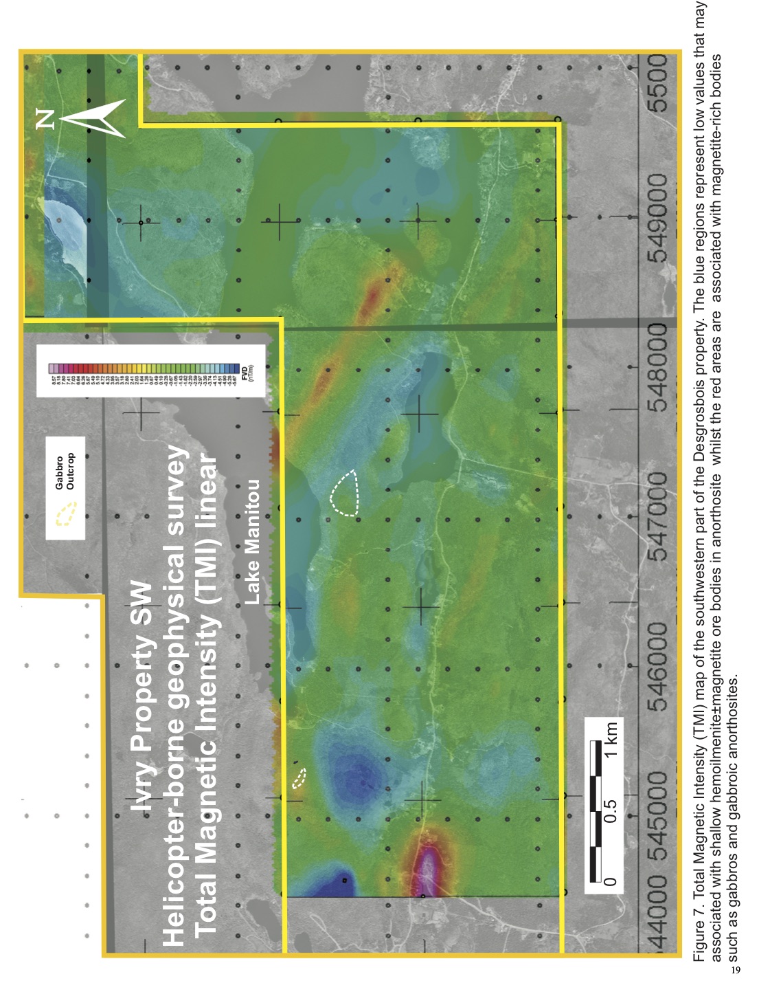
| Figure 7. Total Magnetic Intensity (TMI) map of the southwestern part of the |
|
Desgrosbois property. The blue regions represent low values that may be associated with
| shallow hemoilmenite±magnetite ore bodies in anorthosite whilst the red areas are |
|
| associated with magnetite-rich bodies such as gabbros and gabbroic anorthosites. | 19 |
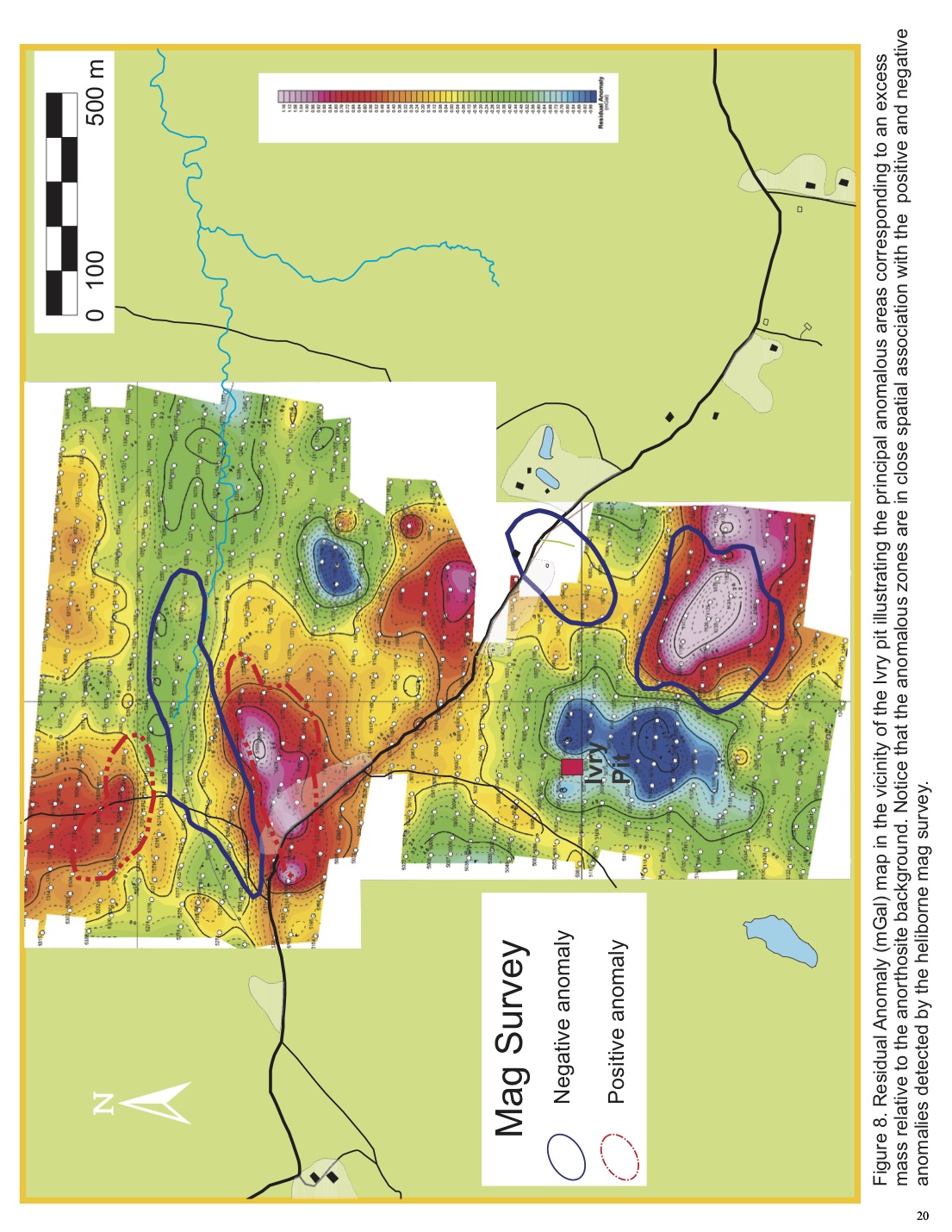
| Figure 8. Residual Anomaly (mGal) map in the vicinity of the Ivry pit illustrating the |
|
| principal anomalous areas corresponding to an excess mass relative to the anorthosite |
|
| background. Notice that the anomalous zones are in close spatial association with the |
|
| positive and negative anomalies detected by the heliborne mag survey. | 20 |
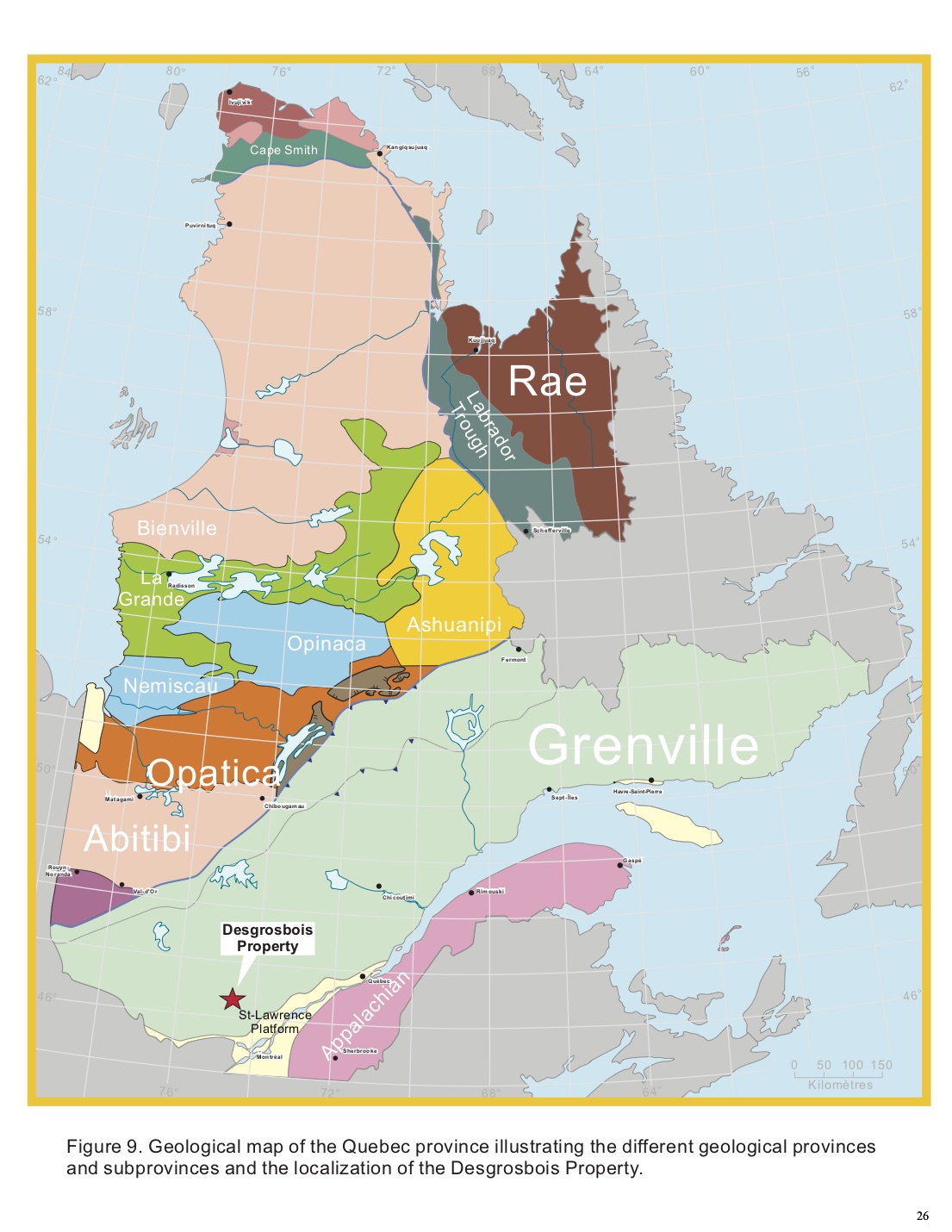
| Figure 9. Geological map of the Quebec province illustrating the different geological |
|
| provinces and subprovinces and the localization of the Desgrosbois Property. | 26 |
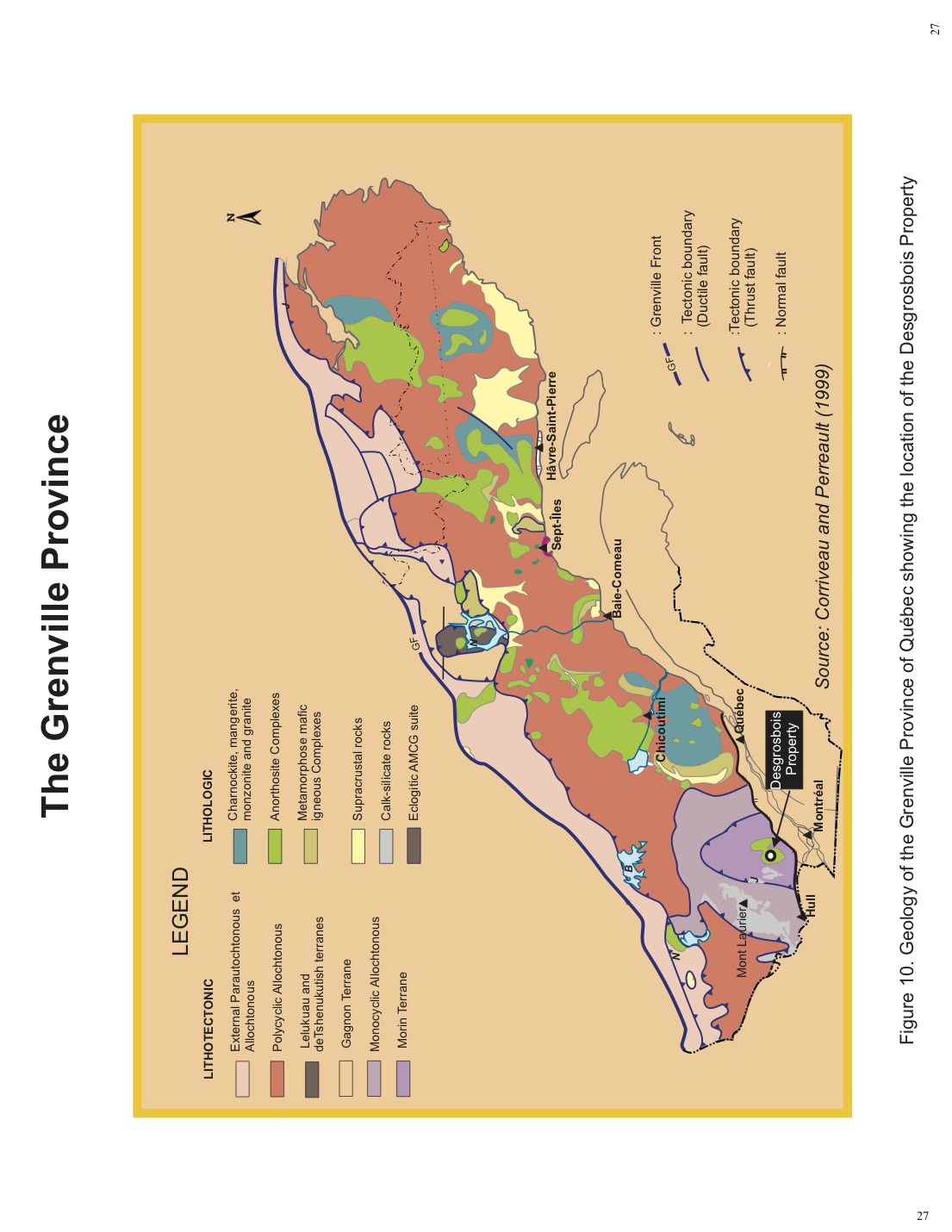
| Figure 10. Geology of the Grenville Province of Québec showing the location of the |
|
| Desgrosbois Property. | 27 |
| Figure 11. Geologic map of the Morin Anorthosite Complex (MAC). | 29 |
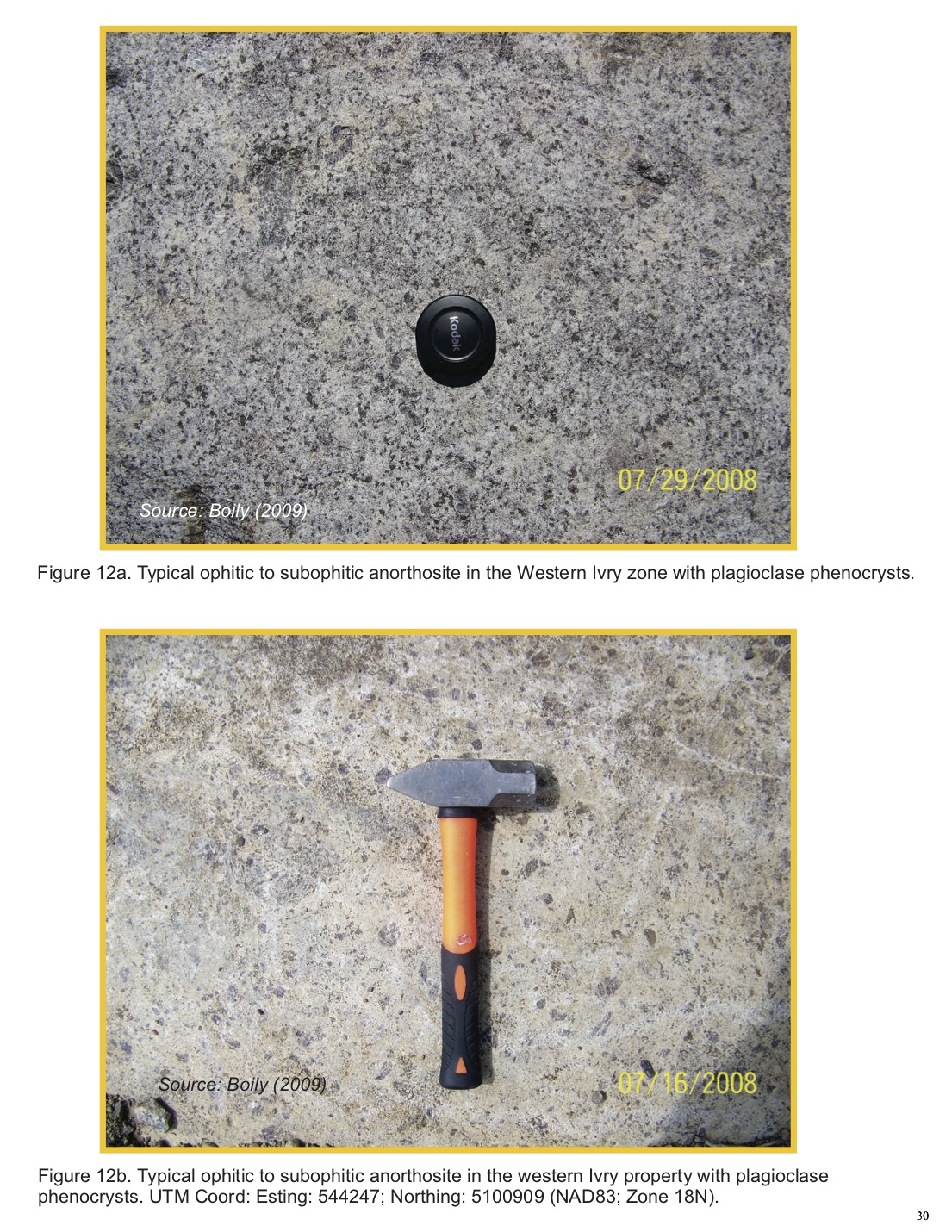
| Figure 12. a and b) Typical ophitic to subophitic anorthosite in the Western Ivry zone |
|
| with plagioclase phenocrysts. | 30 |
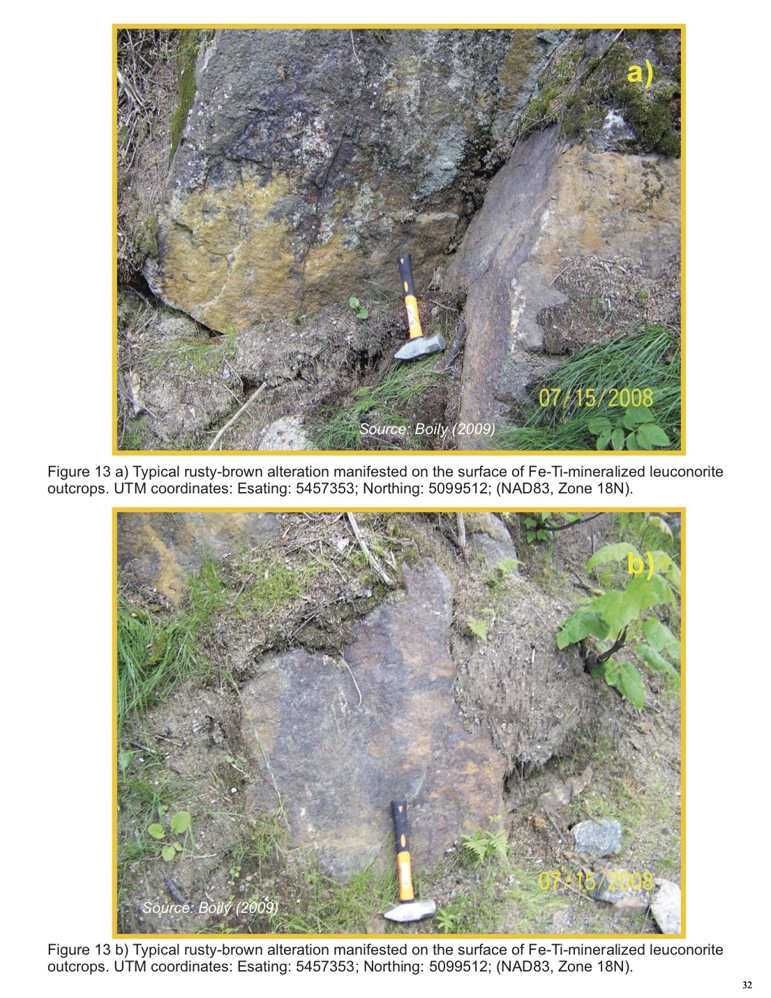
| Figure 13. a and b) Typical rusty-brown alteration manifested on the surface of Fe-Ti- |
|
| mineralized leuconorite outcrops. | 32 |
| Figure 14. a) Rusty-coloured magnetite±ilmenite patches and veins intruding a |
|
| tectonically layered anorthosite/leuconorite; b) Contact between a magnetite±imenite- |
|
| mineralized crushed leuconorite and an anorthosite crisscrossed by veins and patches |
|
| of magnetite±ilmenite. | 34 |
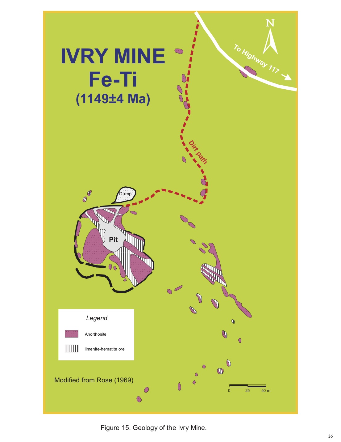
| Figure 15. Geology of the Ivry Mine. | 36 |
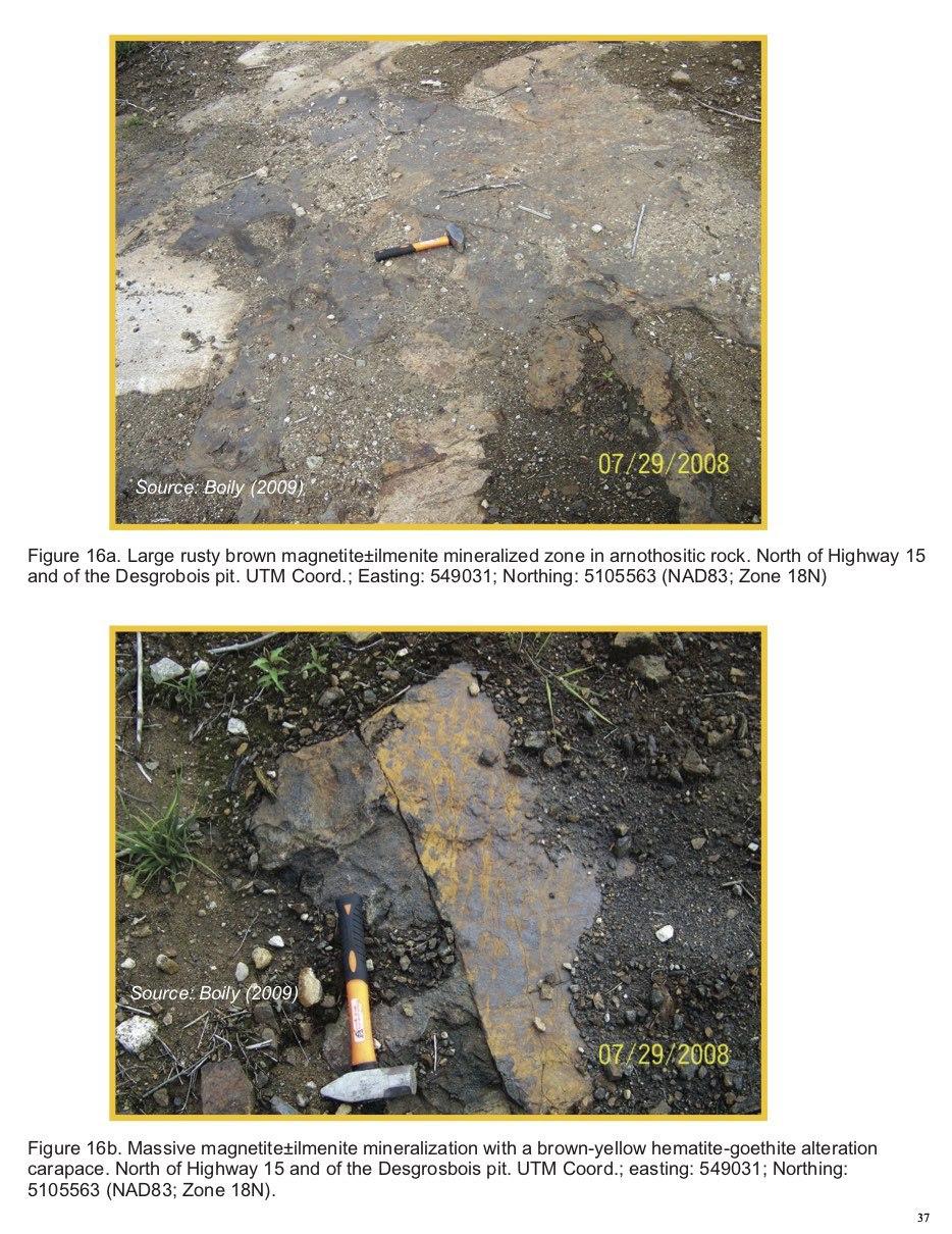
| Figure 16. a) Large rusty brown magnetite±ilmenite mineralized zone in anorthositic |
|
| rock; b) Massive magnetite±ilmenite mineralization with a brown-yellow |
|
| hematite alteration carapace. | 37 |
v
|
|
|
| LIST OF TABLES | |
|
| |
| Table 1. Net Tonnage Estimations for Zones A, B and C calculated by the 3D Gravity |
|
| Inversion Modelling Method. From Boily (2009). | 22 |
| Table 2. Geochemical composition of the massive mineralization at the Desgrosbois and |
|
| Ivry mines. From Boily (2009) | 23 |
| Table 3. Fe-Ti mineralized rocks collected from the West Ivry and North Desgrosbois |
|
| zones during the 2008 summer field campaign. From Boily (2009). | 24 |
|
| |
| APPENDICES | |
|
| |
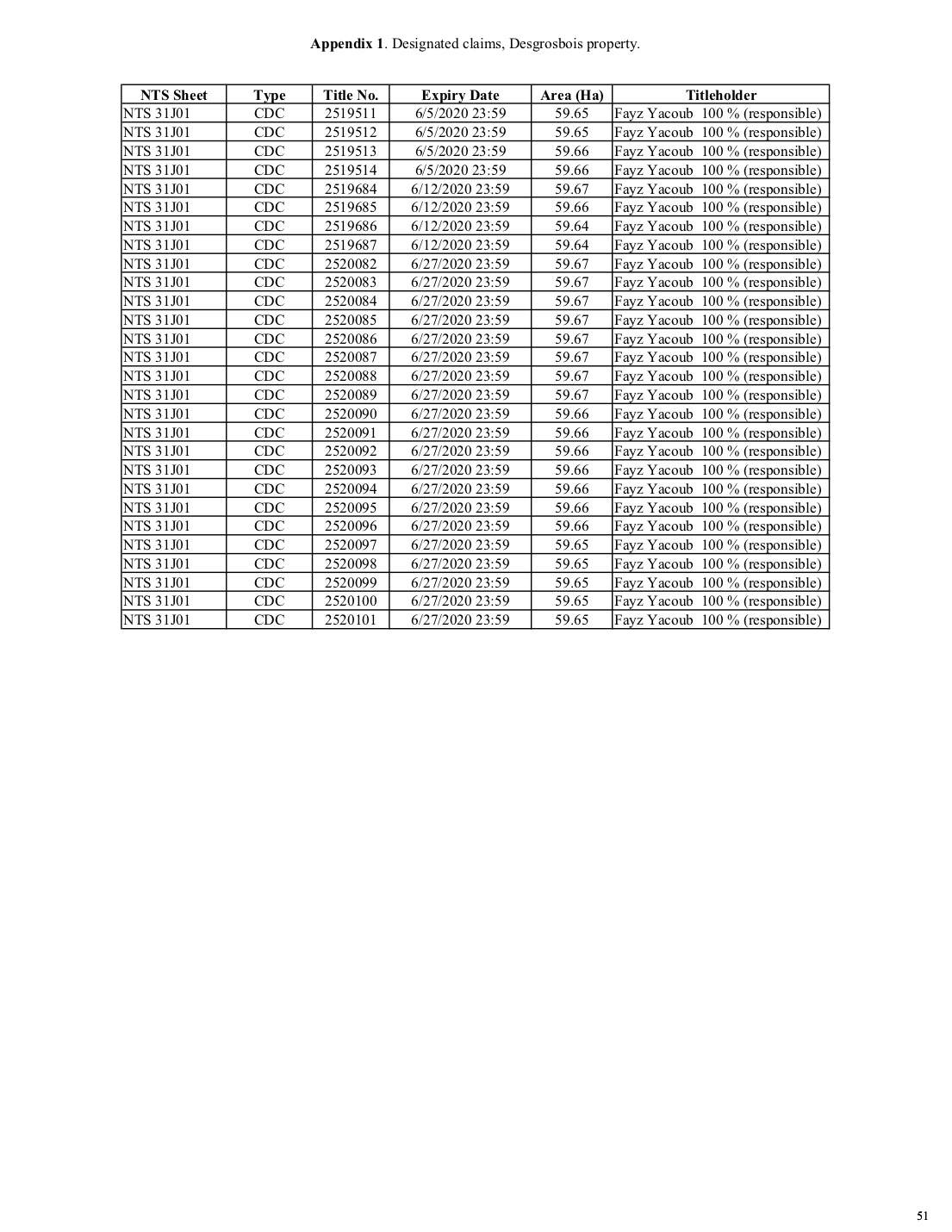
| Appendix 1. Designated claims, Desgrosbois property. | 51 |
vi
ITEM 1 SUMMARY
Aeromagnetic and ground-based gravimetric surveys conducted on the Ivry-Desgrosbois Fe-Ti-V Property in 2007-2008 indicated a substantial potential for undiscovered mineralization in the vicinity of the old Ivry and Desgrosbois past producing open pit mines. The results obtained from both surveys indicate positive or negative magnetic anomalies associated with existing bodies containing massive or disseminated Fe-Ti mineralization (ilmenite and magnetite-rich). This potential was hinted earlier by two limited drilling campaigns ran in the 1950’s that established historical, pre NI-43-101 historical mineral resources of 2.96 Mt of ore averaging 38.5 wt.% Fe and 30.84 wt. % TiO2 (Ivry; Hough, 1952) and 5.53 Mt grading 40.82 wt. % Fe and 10.99 wt. % TiO2 (Desgrosbois; Hendricks,1954). Geochemistry of mineral samples collected by the author from the Ivry pit confirms the high Fe2O3T and TiO2 concentrations obtained by several investigators over the last 80 years. The Fe2O3T and TiO2 concentrations are constrained between 55.91-57.90 wt.% and 31.9-34.0 wt.% respectively, with significant V2O5 values e.g. 0.482-0.513 wt. %. The North Desgrosbois zone massive ore samples carry relatively high V2O5 concentrations (0.28-0.35 wt. %) These results also confirm the unexplored potential of the Desgrosbois property for economic vanadium mineralization.
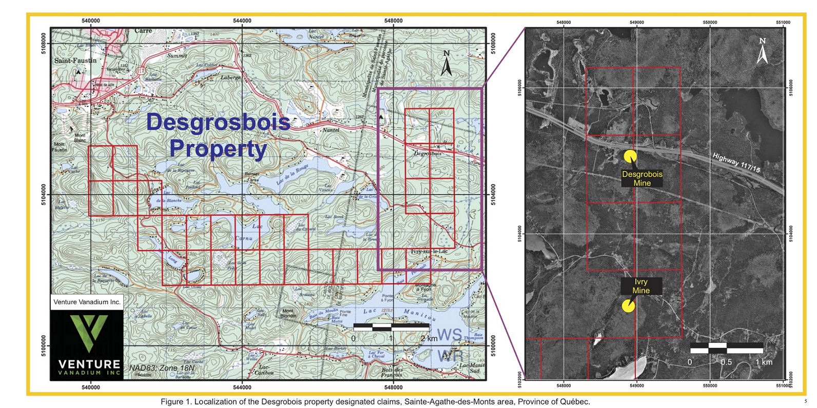
The Desgrosbois property is located in southern Quebec in the regional municipality of Sainte-Agathe-des-Monts and Saint Faustin, Beresford Township, NTS map sheet 31J01. The Property consists of 30 mineral claims (polygons) owned in their entirety by for a total area of 1970 hectares. Mr. Fayz Yacoub.owns 100% of the claims. The Precambrian rocks underlying the Ivry Property are part of the Canadian Grenville Province and are included in the Morin Complex (MC).
The MC is an 1155±3 Ma post-Elzevirian orogenic plutonic suite consisting of anorthosite, jotunite and mangerite. The Ivry-Desgrosbois property is composed of 98% true anorthosite with very subordinate amount of anorthositic gabbro (leucogabbro) and gabbro.
There are two past producing Fe-Ti mines within the confines of the property. Both deposits belong to the magmatic disseminated Fe-Ti oxides (Ti-magnetite and ilmenite) type hosted in anorthosite or mafic intrusions. The old Desgrosbois deposit forms an irregular titaniferous magnetite mass within a dark, rusty weathered medium-grained gabbroic anorthosite and a
1
coarse-grained grey anorthosite. The titaniferous magnetite mineralization occurs in a breccia zone in and near the contact of gabbroic anorthosite and anorthosite. The gabbroic anorthosite is crushed and brecciated together with the anorthosite. Titanomagnetite±ilmenite-magnetite replaces the crushed groundmass. The old Ivry mine is a horse shoe-shaped pit revealing a body of massive hemoilmenite (ilmenitite) that cuts with sharp contact through dark anorthosite and contains large inclusions or horses of the anorthosite. The past helicopter-borne magnetic survey revealed strong magnetic highs concentrated in the northeastern corner of the Property around the old Desgrobois-Ivry deposits and to the southwestern extremities. We interpret the magnetic highs as corresponding to Fe-Ti-V magnetite-bearing bodies of gabbro and/or gabbroic anorthosite. Strong magnetic lows appear in the vicinity of the old Ivry and Desgrosbois pits in the northeastern portion of the Property. These regions constitute targets for future exploration and are interpreted as an indication of Fe-Ti-V oxide bodies at depth principally composed of hemoilmenite or ilmenite possibly enriched in vanadium
A gravimetric study, performed in the vicinity of the old Ivry pit in 2008, produced at least three anomalous areas in the Bouguer and Residual Gravity maps that correspond to excess mass at shallow depth relative to the anorthosite background. The airborne magnetic survey has revealed some interesting anomalies in the western and northern sections of the Desgrosbois property that were further explored in the field by Boily (2009). The region north of the Desgrosbois mine also reveals several exposures of massive veins and irregular bodies of magnetite±ilmenite presenting a brownish-reddish crust. This mode of mineralization is similar to that observed at the Desgrosbois pit.
Analytical results for leucogabbroic mineralized samples collected from anomalous areas in the West Ivry zone show Fe2O3T concentrations varying from 14.94 to 33.31 wt.% with an average of 19.77±5.76, whilst TiO2 ranges from 2.74 to 6.12 wt. %, averaging 4.15±1.02 wt.%. The most interesting assay values are provided by two samples collected from outcrops located west of Lake Brazeau with Fe2O3T concentrations of 24.16 to 33.13 wt. % and 5.17 to 6.12 wt. % TiO2. The best samples of massive ore collected from the North Desgrosbois contain 65.77 and 67.91 wt. % Fe2O3T with 14.45 and 11.20 wt. % TiO2 respectively.
Recommendations are for the company to spend $118,818. On exploration and grab sampling of mineralized specimen to be analyzed for vanadium, SEM analyses, bulk sampling for magnetic separation and metallurgical testing.
2
ITEM 2 INTRODUCTION AND TERMS OF REFERENCE
On December 1st, 2018, Venture Vanadium Inc. mandated Michel Boily (PhD, geo,) to write a 43-101F1 Technical Report on the Desgrosbois Fe-Ti±V property located in the
Beresford Township, in southwestern Quebec, Canada. The Desgrobois property constitutes a property of merit for Venture Vanadium. The purpose of this report is to describe the geological, structural and metallogical characteristics of the property and summarize the exploration work
carried out since the 1950’s. The study is based on in-house reports and documents obtained from Fayz Yacoub, and other public documents (assessment reports and geological reports) and maps acquired from the Ministère de l’Énergie et des Ressources Naturelles du Québec SIGEOM website. Although many authors of such reports appear to be qualified and the information was prepared to standards acceptable to the exploration community at the time, the majority were prepared before the implementation of NI 43-101 norms and the data does not fully meet the present requirements. The author however believes the information provided is verifiable in the field, and portrayed a reasonable representation of the mineralization.
The author has relied upon a limited amount of correspondence, pertinent maps and agreements information that described the MOI into Venture Vanadium entered into the Desgrosbois project. The author has also reviewed the claim titles forming the Desgrosbois property owned by Fayz Yacouband found that they were in good standing. The author does not accept any responsibility for errorspertaining to this information.
Units presented in this report use the metric system. Precious metal concentrations are given in grams of metal per metric ton (g/t) or in parts per million metal (ppm). Tonnage figures are in dry metric tons unless otherwise stated. Currency units used are the Canadian Dollar ($CAD). The weight and the measurement which are used in the course of this study are in conformity with the nomenclature of the international system (IS).
Due to the weather conditions prevailing at the Desgrosbois site during the 2018-2019 wintermonths, the author was unable to perform a site visit (43-101 CP Part 6.2.2 b). The author will
3
travel to the property during when the weather conditions will permit complete access to the property.
ITEM 3 RELIANCE ON OTHER EXPERTS
There is no reliance on other experts.
ITEM 4 PROPERTY DESCRIPTION AND LOCATION
The Desgrosbois property is located in southern Quebec in the regional municipality of Sainte-Agathe des-Monts, Terrebonne and Argenteuil townships, NTS map sheet 31J01. The Property extents north-south between Highway 117 and the southeastern shore of Lake Manitou. From there, it continues along an east-west direction overlying in part lakes Cornu, Long and de La Blanche (Figure 1). The Ivry Property consists of 30 contiguous mineral claims (polygons) for a total area of 1790 hectares or 17.90 km2 (Figure 1). The claim block is centered at coordinates 74.430º W Long. And 46.080° N. Lat. or UTM coordinates 544091m E and 5103135m N (NAD83;Zone 18N), with the details of the titles given in Appendix 1. The Ivry Property was
staked by Mr. Fayz Yacoub through the GESTIM website run by the Ministère de l’Énergie et des Ressources Naturelles du Québec. Mr. Yacoub owns 100% of the claims. The UTM coordinates and grid contours on the geological maps are extracted from the information given on the GESTIM
website.
Pursuant to an Agreement dated November 6, 2018 between Mr. Ian Ilsley of Venture Vanadium Inc. (the “Optionee”) and Mr. Fayz Yacoub (the “Optionor”); the legal and beneficial
owner of an undivided one hundred per cent (100%) interest in and to 30 mineral claims (The Desgrosbois Vanadium-titanium Property) representing 1,789.80 hectares (4,422.69 acres) situated in Quebec within NTS map sheets 31J/01 (the “Property”) situated in the Sainte-Agathe-des-Monts area, the Optionor has agreed to grant an exclusive option to the Optionee entitling the Optionee to acquire an undivided one hundred per cent (100%) interest in and to the Property on the terms and conditions hereinafter set forth;
4
a) The Optionee making the following cash payments to the Optionor: 1) $25,000 within 5 business days of the Effective Date; 2) $25,000 to be paid on or before the 20th of April 2019; 3) An additional $35,000 on or before the first anniversary of the Effective Date; 4) An additional $35,000 on or before the 20th of April 2020; 5) An additional $35,000 on or before the second anniversary of the Effective Date;
b) The Optionee allowing and issuing the following common shares in the capital stock of the Public Company on a recognized North American Exchange into which the Property is vended into (hereinafter the “Public Company”) to the Optionor : a) 500,000 shares deliverable 'within 10 business days of the Property being vended into the Public Company; b) An additional 500,000 shares on or before the 20th of April 2019; c) An additional 500,000 shares on or before the first anniversary of the Effective Date; d) An additional 500.000 shares on or before the 20th of April. 2020; e) An additional 500,000 shares on or before the second anniversary of the Effective Date,
c) The Optionee incurring the following expenditures totaling $400,000 over 2 years on the Property as follows: a) $40,000 on or before October 31st, 2019; b) $80,000 on or before the first anniversary of the Effective Date; c) An additional $280,000 on or before the second anniversary of the Effective Date; d) A two per cent (2.0%) Net Smelter Returns on all metals (hereinafter called the "Royalty”).
According to Quebec government records, no part of the land covered by the property is a park or mineral reserve. The property is devoid of royalties, back in rights, payments or other encumbrances. The Issuer does not hold the claim titles of the Desgrosbois property. The Desgrosbois property is not subject to environmental liabilities except for those specified in the “Loi sur les Mines” (L.R.Q. chapter M-13.1). Mining exploration is currently permitted on the entire surface. There are no other significant factors and risks that may affect access, title, or the right or ability to perform work on the property. The author is unaware of any environmental liabilities, public hazards or any other liabilities associated with the property.
6
The new mining act of Québec requires a claim holder to notify the local municipality, the landowner, the State lessee and the holder of an exclusive lease to mine surface mineral substances of the claim obtained, within 60 days after registering the claim in the register of real and immovable mining rights, and in the manner determined by regulation. A claim holder also needs to notify the local municipality and the owner of the land on which the claim is situated of the work that will be carried out, at least 30 days before the work begins.
The new mining act of Quebec allows a company or an individual to hold a claim up to a period of two years before renewal. When a claim is located below 52° lat., its renewal fee is set at $32.77 when presenting an area <25 ha. Claims having an area ranging between 25 and 100 ha cost $64.09 upon renewal. The owner or optionor also must spend a minimum of $780 on each claim on exploration work (i.e. geological mapping, geophysical survey, drilling…) for the claim to remain in good standing. The renewal must be forwarded to the Quebec government, at a cost, 60 days before the claim expiration date. The renewal is obtained only if the exploration expenses satisfy all the requirements demanded by the Ministère de l’Énergie et des Ressources du Québec.
Part of property claims are located on Crown Land, and the Issuer is allowed legal access to all parts of the land staked and acquired surface rights to conduct exploration work year round. Other claims are situated on private land, and the Issuer must come to a written agreement with the owner of the land before starting any exploration work. The claims owned by the Optionee are currently valid and in good standing. All claims expire in June 2020.
ITEM 5 ACCESSIBILITY, CLIMATE, LOCAL RESOURCES INFRASTRUCTUREAND PHYSIOGRAPHY
Access to the Desgrosbois Property is via Highway # 15 going north from Montreal for roughly 80 km until the Highway 15 changes into Highway 117. From there, there are numerous paved and gravel roads that crisscross the property site. To reach the old Ivry mine, we must travel 800 meters on Highway 117 from the intersection with Highway 15, and then turn left to engage the
7
Chemin Renaud. 3.6 km later, we attain a small bridge crossing over Lake Manitou, near the Ivry Townhall, where we take the Chemin de la Grise road for 1.74 km. The ancient dirt path going to the old Ivry Mine can be seen on the south side of the road. The mine is located 380 m to the south. The Desgrosbois showing/pit is easily attainable via Highway 117. Travelling 8.0 km NNW from the Highway 117/15 intersection, we turn back at a crossing to re-engage Highway 117 in a SSW direction for 310 meters. The Desgrosbois showing and pit is situated just 40 to 50 m south of the roadside.
The Desgrosbois Property is underlain by massive Precambrian granitoids and gneisses. A wide range of physiographic features characterize this ecoregion, most of which are the result of glaciation. The topography is typical of the Canadian Shield, i.e. rolling or undulating and glacial drift-covered hills reaching between 60 to 500 m in height with an abrupt network of rivers and numerous lakes of irregular shapes. The vegetation, adapted to the harsh climate and altitude, typifies the mixt boreal forest. Deciduous trees such as the white birch and poplar are interspersed with conifers dominated by black and white spruce, gray pine and aspen. The entire ecoregion provides prime habitat for many species, including moose, black bear, lynx, and red fox. Beaver, porcupine, raccoon and rabbit are common. The Sainte-Agathe-des-Monts area is characterized by a continental climate. Summers (mid-May to mid-September) are short but temperate with average maxima and minima of 23.7°C and 11.9°C (July) and a moderate amount of rain (41.1 cm). Winter is harsh and starts in November and lasts until April, with an extensive snow cover (373 cm) from November to April. Average temperatures reach –18.7°C (min) and –7.8°C (max) in January.
Water for drilling can be obtained from the numerous streams and lakes throughout the property including from Le Cornu and De la Blanche lakes. A Hydro-Quebec 720 kv power line run EW across the northeastern segment of the property near Highway 117.
The nearest major town from the property is Sainte-Agathe-des-Monts (pop. 10,223), which is situated only 5 km SE of the main Ivry showing. It harbors a hospital, commerce and restaurants. This region of the Canadian Shield, the Lower Laurentians, is a well-known summer and winter resort area. They are numerous summer houses and camping grounds dispersed around the many lakes and rivers surrounded by rolling hills. During winter, cross-country and alpine skiing are the main economic activities of the region as well as snowmobile rides. Montreal (pop. 1,705,000) located just 80 km south of Sainte-Agathe-des-Monts will provide all the technical expertise, manpower and resources necessary for the development of a mining property.
8
There are no mineral resources or mineral reserves on the Desgrosbois property according to the 2005 CIM Definition Standards. There are however two existing mine workings/open pits associated with the Desgrosbois and Ivry deposits from which ilmenite ore was extracted during the early 1900's. Some small waste material is present at the Ivry open pit. No tailing ponds, and important natural features and improvements relative to the outside property boundaries can be seen. There is sufficient unused land within the Ivry claim blocks for waste and tailing disposal and the construction of a mine and milling installations. However, most of the land is privately owned and the Company will have to spend considerable efforts to obtain the permission of the municipal and provincial authorities as well and land owners to be able to conduct any mining operations.
The optimum length of the operating season in the St-Agathe area ranges from Early May to Late November when mining companies usually conduct their field work such as geological mapping, drilling, overburden stripping, trenching, soil survey and sampling. However, airborne and ground-based geophysical surveys and drilling can be carried out yearlong, except for radiometric surveys.
ITEM 6 HISTORY
6.1- Introduction
The first serious geological and metallogenic investigation of the Ste-Agathe-des-Monts and St-Jovite regions is that of Osborne (1936) who described and mapped the geology of the Morin Complex in particular and proceeded to establish an inventory of the mineralized zones of the area. McGerrigle (1961, 1962) systematically mapped a region corresponding to part of the NTS sheet 31J01 in the Beresford Township. The area includes the old Ivry and Desgrosbois mines and covers exclusively the anorthosites of the Morin Complex. Rose (1969) provides a geological summary of the Fe-Ti deposits occurring within the Morin Complex anorthosites. A wealth of petrological, geological and structural studies concern directly the Morin Complex (see Martignole and Shriver, 1970; Emslie, 1975 and Doïg, 1991). In particular Emslie’s report gives a detailed description of the prevalent rock types of the Morin Complex.
6.2- The Desgrosbois Deposit
1913- The Desgrosbois deposit was discovered in 1913 by Dulieux (1913) who collected samples from lot 39 and
40 (Range VI, Argenteuil Township) and later submitted them to chemical assaying and beneficiation.
1949- The Property was acquired by Pershing Amalgamated Mines Ltd. which carried out a systematic dip needle survey. The company opened a small pit on the northern flank of a small hill in lot 39, 80 m from Road 117. The pit is 55 m long and 40 m wide.
1950- R. Leblanc reported historical resources of 30,000 tons per vertical feet on lots 40 and 41
and 16,000 tons per vertical feet on lot 39 (Bourret, 1958).
9
1952- A detailed magnetometer survey was conducted over lots 38 to 41. Two strong magnetic anomalies were detected. A circular anomaly with a diameter of approximately 225 m, situated in lot 39 and in the west part of lot 38, extended south and east of the open cut. The other anomaly was located on a rise on the west
side of a swamp opposite to the open pit. The anomaly is roughly 200 m long with a general EW- strike and the width varies between 15 and 50 m (Hagan, 1952; GM 02057). The first anomaly was drilled by Pershing Amalgamated for a total of 22 holes and 1192 meters, whilst the second was subjected to one DDH (Hendricks, 1954; GM 02729).
1953-1958- Laboratory test and beneficiation of the ore were conducted. A 1955 report produced by N. Soludocha evaluated the commercial utilization of titaniferous magnetite detailing the production costs and the design of the projected plant and equipment. In 1956 grinding tests were performed by Aerofall Mills Co. (Ensio, 1956; GM 05103C). The Mines and Technical Survey branch in Ottawa also did some research at a pilot plant in 1957 (Bourret, 1958).
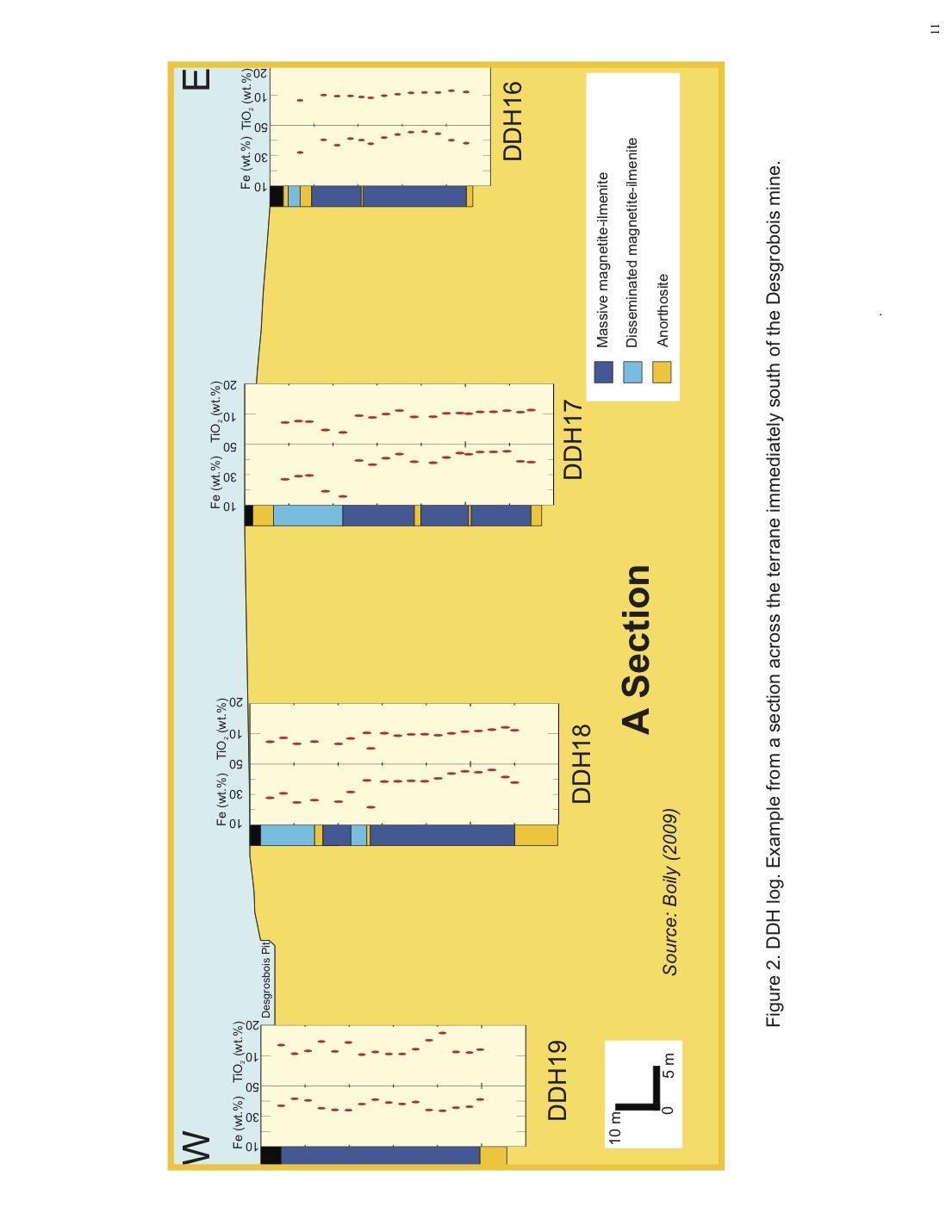
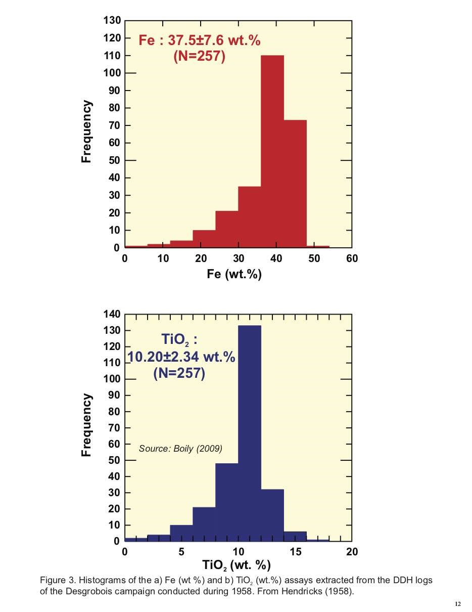
We have accurate information relative to the localization of the core holes drilled during the 1958 campaign at the old Desgrosbois mine. All DDH are vertical and reach thicknesses ranging from 40 to 80 m (Figure 2). The core sections illustrate massive magnetite-ilmenite zones reaching 50 m in thickness with subordinate sections of disseminated mineralization commonly occurring within the first 30 m of core. The overall impression of the mineralization is of a sub-horizontal mass comprised in a 220 x 110 m area with a thick N and NW section near the old Desgrosbois pit tapering gradually toward the southeast. A subhorizontal section of disseminated magnetite-ilmenite mineralization is present in the first 30 m. The histograms of the Fe (wt. %) and TiO2 (wt. %) assays extracted from the core logs of Hendricks (1958; GM 11645), indicate similar skewed shapes reflecting the dominance of massive titanomagnetite sections. Average concentrations of the Desgrosbois mineralization are: 37.5±7.6 wt. % Fe and 10.20±2.34 wt. % TiO2 (Figure 3).
Hendricks (1954) established a calculation that indicated historical resources of 5.523 Mt of ore grading 40.82 wt. % Fe and 10.99 wt. % TiO2 with an average thickness of 30 m. The ore zone lies in an elliptical shaped area with long and short dimension of 300 and 200 m respectively.
10
1959-1960- Lumau Mining Corp. acquired the mining rights on the property and adjacent claims on which a ground-based magnetometer survey was conducted (Hendricks, 1960; GM 11645). Brossard (1960; GM 10250) collected 20 samples around the Desgrosbois pit in the southern part of lot 39, range V. The assay results produced an average of 31.96 wt. % Fe and 8.47 wt. % TiO2 while the massive material went as high as 45.5 wt. % Fe and 11.2 wt. % TiO2.
1968-1970- Nine DDH were drilled at the periphery or in the center of the Desgrosbois pit, while three other holes were placed on the northern side of Highway 117 in lot 38, range VI on what was called the Yates-Hanckock property (Anonymous, 1968; GM 23497 and Anonymous, 1971; GM 26675).
6.3-The Ivry Deposit
1910-1918- The Ivry ilmenite deposit was opened in 1910. From 1912 to 1918, when production terminated, a total of about 16,000 tons of ilmenite ore was shipped to the Titanium Alloy Company of Niagara Falls, New York for use in the manufacture of ferrotitanium, a deoxidizer of steel (Rose, 1969).
1951-1952- The results of a magnetic survey performed by R.J.M. Baxter, which suggested that the Ivry deposit extends to the east by outlining a magnetic zone 2790 m2 in extent, has been described by Leblanc (1951; GM 01119). The latter also refers to a magnetic separation test and assays for Ti and Fe performed by the American Smelting Company. In 1952, Hagan (1952; GM02057) put forward a detailed plan for open pit development of the old Ivry mine. A geophysical survey of the Ivry site was conducted by Geo-Technical Development Co. along NS traverse lines for a total of 8.34 km (Hough, 1952; GM 01726).
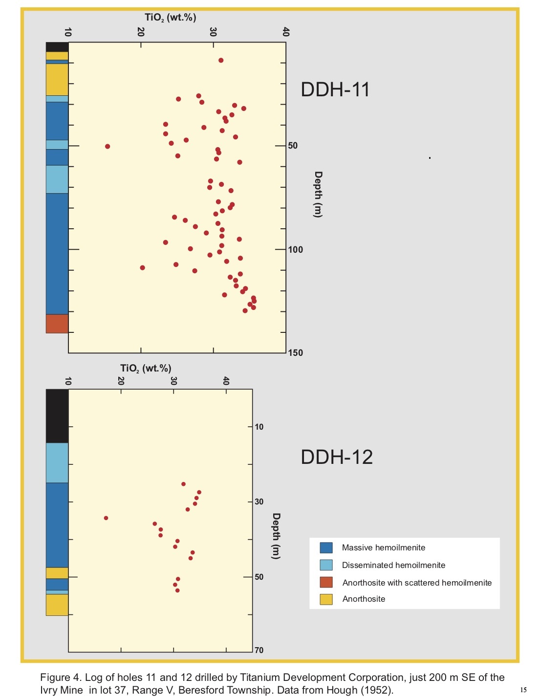
Titanium Development Corporation conducted a drilling program southeast of the deposit in the eastern half of lot 36 and in lot 37. The location of the drill holes fall within a well-defined negative magnetic anomaly detected from a heliborne geophysical survey. The drilling program consisted of 16 holes totaling of 1228 m of core. The azimuth and plunge (45º) of each DDH is known from the report of Hough (1952), however the exact location of each hole is unknown so
13
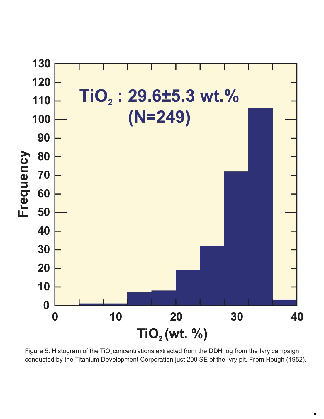
we can only interpret the drill log in a general way without spatial constraints (Figure 4). In general, the core stratigraphy reveals zones of massive hemoilmenite (ilmenitite) layers reaching in some cases 20 to 30 m in apparent thickness alternating with zones of disseminated ilmenite injections. There are numerous barren anorthosite zones of moderate apparent thickness (e.g. 10 cm to 5 m) appearing throughout the mineralized column. The apparent depth reached by the 16 holes varies from 40 to 175 m which corresponds with a plunge of 45º to real thicknesses of 28 to 124 m. A histogram of the TiO2 (wt. %) assays extracted from Hough (1952) is provided in Figure 5. The compilation relates only to massive and disseminated ore. The skewed shape of the histogram reflects the variation from disseminated to massive ore. However, the average TiO2 concentration is high: 29.6±5.3 wt. %.
Hough (1952) established an evaluation for the Titanium Development Corporation that produced historical resources of 2.95 Mt averaging 30.84 wt. % TiO2 and 38.5 wt. % Fe. This figure represents material grading in excess of 30 wt. % TiO2 taken to a depth of 100 m below the surface.
1958-1959- McGerrigle (1962) mentioned that in 1958, 58 DDH totalizing 1103 m were drilled in the eastern part of lot 38. The report does not state the name of the company for which the core drilling was done but we may speculate that it was for Heavy Rock Mines Limited. In 1958-1959, the aforementioned company reopened the deposit and was said to have shipped about 36,000 tons of ilmenite ore to Montreal for use as heavy aggregate (see Rose, 1969).
An estimated historical resources of 160,780 tons of ore based on the results of the drilling campaign undertaken for Heavy Rock Mines Ltd. (?) south of the Ivry pit, is quoted in McGerrigle (1961). The calculation assumed that the ore zone extended 20 meters in depth and was limited on the surface by the southeastern edge of the pit and the boundary between lots 38 and 39 (Range VI).
1975- An extensive study concerning the development of the bulk leach system for the recovery of low-residual titanium dioxide from titaniferous ores was carried out for the Ministère des Richesses naturelles du Quebec in 1975 by International Titanium Development (Stethem, 1975;
14
GM 31119). The report also delved on the beneficiation of ore by magnetic separation, gravity separation, flotation of sulfides from the ore, electrostatic separation, ore leaching and hydrolysis of TiO2.
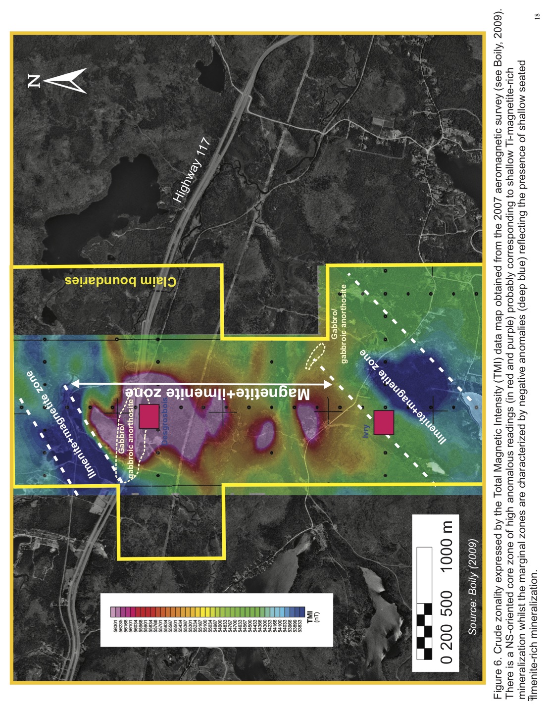
2007- A helicopter-borne magnetic geophysical survey of 400 line-km was flown over the Ivry Property by GPR Géophysique Inc. on behalf of Trijet Mining Corp. Results from the helicopter-borne magnetic survey conducted over the Ivry Property are illustrated by the Total Magnetic Intentsity (TMI) maps (Figures 6, 7) (Boily, 2009). The TMI displays apparently a complex pattern of magnetic highs and lows, the former concentrated in the northern area of the old Ivry-Desgrosbois property. The strong magnetic highs are found in the northeastern corner of the property around the Desgrosbois deposit and to the southwestern extremities. Gabbroic bodies correspond to strong magnetic highs on the maps. Oriented linear or curved features underlined by moderate magnetic highs could corresponds to bands or layers of fine- grained mafic or gabbroic anorthosite or gabbroic lenses that may constitute more than 10% of the rock exposures in certain domains of the Morin Complex (see McGerrigle, 1962). The magnetic lows, are shown in blue, and mainly occur in the vicinity of the Ivry and Desgrosbois pits. The regions revealing strong magnetic lows (TMI) or important negative FVD values were interpreted as an indication of Fe-Ti oxide mineralization at depth principally composed of hemoilmenite or ilmenite (Boily, 2009).
2008- A ground based gravimetric survey was completed along a grid established in the vicinity of the old Ivry mine. It was completed by Abitibi Geophysics Inc. (Boulanger and Cifuentes, 2008). The results of the ground-based gravity survey conducted in the area surrounding the old Ivry pit are presented in the form of Bouguer Anomaly map (Figure 8). The map reveals anomalous areas corresponding to rock bodies with higher densities than the surrounding anorthositic background (2.74 g/cm3). The results of the gravity survey is best explained assuming that the excess mass correspond to densities of 4.1 g/cm3 a composite of ilmenite and magnetite ore. The anomalous regions are underlined by the red and orange signatures. They are in close spatial association with positive and negative anomalous zones detected by the airborne mag survey.
17
|
|
|
|
|
|
A three-dimensional geophysical inversion model was completed to estimate a net tonnage of the ilmenite-magnetite-rich bodies by choosing a density contrast threshold of 0.3 g/cm3 (mixed rock of anorthosite and ilmenite±magnetite mineralization) and of 0.5 g/cm3, (corresponding to a density interval of 3.24 to 4.09 g/cm3, showing the more dense rock). Results of height, depth, and tonnage of the three targets zones are presented in Table 1. In the first hypothesis, a net tonnage of 16.8, 8.5 and 6 Mt was found for three target zones. The second estimation which is likely more realistic, assess the net tonnage to 4.6, 0.9 and 1.1 Mt. Therefore, it was estimated zones A, B and C there could carry a tonnage of 12.4, 7.6 and 4.9 Mt that is bracketed by a density of 3.05 to 3.24 g/cm3.
Boily (2009) devoted six days on the western end of the property exploring and collecting samples of Fe-Ti mineralized rocks as well as sampling the principal host lithologies. A prospector was hired for three days to roam and to collect samples from two principal “hot zones” that were most susceptible to contain Fe-Ti mineralization. These areas were outlined by the location of the airborne magnetic anomalies outlined by Abitibi Geophysics and the recognition of Fe-Ti mineralization by the author and as well as by McGerrigle (1962).
Samples from the old Ivry pit, four of these samples represent the hemoilmenite mineralization (ilmenitite) and two of the anorthosite gangue were collected by Boily (2009) and the chemical analyses were compared to that of published assays from the Ivry ore sampled since the early 1900’s (Tables 2 and 3). Note the V contents are slightly higher than those reported by Rockow (1975) (2700-2870 ppm or 0.482-0.513 V2O5 (wt. %)). Two anorthosite specimen, one containing disseminated hemoilmenite (MBIV07-08), were also analyzed. The samples from the Desgrosbois mine come from the pit walls and are typical of the gabbroic anorthosite (leuconorite) of the Morin Complex. The west Ivry sampled area was within boundaries delineated to the north by a NE-SW oriented line following lakes Brazeau, Nelly and Caché and to the south by the Chemin des Lacs road. The Fe2O3T concentrations vary from 14.94 to 33.31 wt. % with an average of 19.77±5.76 whilst TiO2 ranges from 2.74 to 6.12 wt. %, averaging 4.15±1.02 wt. %. The most interesting assay values are provided by two samples collected from outcrops located west of Lake Brazeau with Fe2O3T concentrations of 24.16 to 33.13 wt. % and 5.17 to 6.12 wt. % TiO2. From the North Desgrosbois zone, the best samples representing the
21
Table 1. Net Tonnage Estimations for Zones A, B and C calculated by the 3D Gravity Inversion Modelling Method. From Boily (2009)
|
|
|
|
|
|
| Zone | Top (m) | Bottom (m) Height (m) Tonnage (tonne) | ||
|
| ||||
|
|
| Threshold: 0.3 g/cm3 (3.04 to 4.09 g/cm3 ) | ||
|
| ||||
| A | 508 | 408 | 100 | 16,880,471 |
| B | 508 | 433 | 75 | 8,584,375 |
| C | 508 | 445.5 | 62.5 | 6,158,007 |
|
| ||||
|
|
| Threshold: 0.5 g/cm3 (3.24 to 4.09 g/cm3 ) | ||
|
| ||||
| A | 508 | 458 | 50 | 4,660,548 |
| B | 508 | 483 | 25 | 944,922 |
| C | 508 | 470.5 | 37.5 | 1,089,062 |
| Cell volume: 12.5 m3 |
|
|
| |
Density for Net Tonnage Estimation: ilmenite±magnetite ore 4.1 g/cm3; anorthosite: 2.74 g/cm3
22
|
|
|
|
|
|
|
|
|
|
|
|
|
|
|
|
|
|
|
|
|
|
|
|
| Table 2. Geochemical composition of the massive mineralization at the Desgrobois and Ivry mines. From Boily (2009) |
|
| ||||||||||||
|
| ||||||||||||||||||
|
| ||||||||||||||||||
| SAMPLE | SiO2 (wt.%) | Al2 | O3 | Fe2 | O3T | K2 | O | MgO | MnO | Na2 | O | TiO2 | V2 | O5 | Cr | P2 | O5 | S |
|
| ||||||||||||||||||
|
|
|
|
|
|
|
|
| Desgrobois |
|
|
|
|
|
|
|
|
|
|
|
| ||||||||||||||||||
| D G0804 | 6,83 | 3,98 |
| 65,77 |
| 0,06 |
| 1,64 | 0,22 | 0,25 |
| 14,45 | 0,31 |
|
|
|
|
|
| D G0805 | 0,81 | 2,68 |
| 67,91 |
| 0,01 |
| 0,60 | 0,25 | -0,01 |
| 11,20 | 0,28 |
|
|
|
|
|
| D G0831 | 6,48 | 2,89 |
| 53,04 |
| 0,09 |
| 2,24 | 0,17 | 0,37 |
| >20 | 0,35 |
|
|
|
|
|
|
| ||||||||||||||||||
|
|
|
|
|
|
|
|
| Ivry |
|
|
|
|
|
|
|
|
|
|
|
| ||||||||||||||||||
| Rockow1 | 3,41 | 1,76 |
| 57,67 |
| 0,08 |
| 2,39 | 0,15 | 0,28 |
| 34,70 | 0,29 |
| 499 | 0,00 |
| 0,00 |
| MBIV07-06 | 2,30 | 1,46 |
| 55,91 |
| 0,04 |
| 1,70 | 0,20 | 0,14 |
| 34,00 | 0,51 |
| 180 | 0,02 |
| 0,45 |
| MBIV07-07 | 4,97 | 2,67 |
| 55,33 |
| 0,08 |
| 1,83 | 0,16 | 0,34 |
| 31,90 | 0,48 |
| 10 | 0,02 |
| 1,09 |
| IVMB07-01 | 6,17 | 2,66 |
| 53,19 |
| 0,09 |
| 2,66 | 0,18 | 0,37 |
| 31,90 | 0,49 |
| 10 | 0,07 |
| 1,07 |
| IVMB07-03 | 2,86 | 1,56 |
| 57,90 |
| 0,06 |
| 2,13 | 0,17 | 0,14 |
| >20 | 0,51 |
| 10 | 0,05 |
| 0,57 |
23
Table 3. Fe-Ti-mineralized rocks collected from the West Ivry and North Desgrobois zones during the 2008 summer field campaign. From Boily (2009).
|
|
|
|
|
|
|
|
|
|
|
|
| SAMPLE # SiO2 (wt.%) | Al2 O3 | Fe | Fe2 O3 | K2 O | MgO | Mn | Na2 O | TiO2 | V V2 O5 | Rock Type |
|
|
|
|
|
|
|
|
|
|
|
|
|
|
|
|
|
|
|
| Ivry West |
|
|
|
|
|
|
|
|
| ||||||||||||
| C 310701 | 33,40 | 6,37 | 23,30 | 33,31 | 0,36 | 5,90 | 0,33 | 1,28 | 6,12 | 0,04 | 0,07 | Fe-Ti mineralized leuconorite |
| C 300702 | 39,00 | 11,25 | 16,90 | 24,16 | 0,51 | 4,35 | 0,20 | 2,21 | 5,17 | 0,04 | 0,07 | Fe-Ti mineralized leuconorite |
| C 310703 | 44,80 | 13,80 | 12,65 | 18,09 | 0,86 | 3,82 | 0,17 | 2,74 | 3,83 | 0,03 | 0,05 | Fe-Ti mineralized leuconorite |
| C 310708 | 47,00 | 13,10 | 12,45 | 17,80 | 0,97 | 3,25 | 0,18 | 2,73 | 4,41 | 0,03 | 0,05 | Fe-Ti mineralized leuconorite |
| IVW 0808 | 46,30 | 12,70 | 12,70 | 18,16 | 1,29 | 3,12 | 0,16 | 2,64 | 4,38 | 0,03 | 0,05 | Fe-Ti mineralized leuconorite |
| IVW 0813 | 47,80 | 15,10 | 10,90 | 15,58 | 1,09 | 3,40 | 0,17 | 3,38 | 3,28 | 0,02 | 0,04 | Fe-Ti mineralized leuconorite |
| IVW 0814 | 50,60 | 15,30 | 10,45 | 14,94 | 1,63 | 2,33 | 0,16 | 3,11 | 2,74 | 0,02 | 0,04 | Fe-Ti mineralized leuconorite |
| IVW 0815 | 47,50 | 14,20 | 11,35 | 16,23 | 1,17 | 3,89 | 0,19 | 3,21 | 3,66 | 0,03 | 0,05 | Fe-Ti mineralized leuconorite |
| IVW 0825 | 42,80 | 13,60 | 13,75 | 19,66 | 0,72 | 4,19 | 0,19 | 2,67 | 3,81 | 0,02 | 0,04 | Fe-Ti mineralized leuconorite |
|
| ||||||||||||
|
|
|
|
| Desgrobois North |
|
|
|
|
|
|
| |
|
| ||||||||||||
| D G0803 | 54,50 | 24,20 | 2,27 | 3,25 | 0,93 | 1,06 | 0,03 | 4,83 | 0,61 | 0,00 | 0,01 | Anorthosite |
| D G0804 | 6,83 | 3,98 | 46,00 | 65,77 | 0,06 | 1,64 | 0,17 | 0,25 | 14,45 | 0,17 | 0,31 | Massive Ti-magnetite±ilmenite |
| D G0805 | 0,81 | 2,68 | 47,50 | 67,91 | 0,01 | 0,60 | 0,19 | -0,01 | 11,20 | 0,16 | 0,28 | Massive Ti-magnetite±ilmenite |
| D G0806 | 38,90 | 18,30 | 15,15 | 21,66 | 0,64 | 0,87 | 0,06 | 3,27 | 4,10 | 0,05 | 0,09 | Fe-Ti mineralized anorthosite |
|
|
|
|
|
|
|
|
|
|
|
|
| Anorthosite with disseminated |
| D G0807 | 50,40 | 22,30 | 6,38 | 9,12 | 0,80 | 1,56 | 0,05 | 4,08 | 1,28 | 0,02 | 0,03 |
|
|
|
|
|
|
|
|
|
|
|
|
|
| Fe-Ti mineralization |
| D G0831 | 6,48 | 2,89 | 37,10 | 53,04 | 0,09 | 2,24 | 0,13 | 0,37 | >20.0 | 0,19 | 0,35 | Massive ilmenite |
24
massive ore, DG0804 and DG0805, contain 65.77 and 67.91 wt. % Fe2O3T with 14.45 and 11.20 wt. % TiO2 respectively. The high concentrations of Fe2O3T in the massive ore can be correlated with those obtained for the 1958 drill core south of the Desgrosbois pit. The North Desgrosbois zone massive ore samples carry relatively high V2O5 concentrations (0.28-0.35 wt. %) which are slightly lower than those quoted by Boily (2009) for the Ivry massive ilmenite ore (V2O5=0.48-0.51 wt. %). These results also confirm the unexplored potential of the Desgrosbois property for economic vanadium mineralization.
ITEM 7 GEOLOGICAL SETTING
7.1-The Grenville Province
The Precambrian rocks underlying the Ivry Property are part of the Canadian Grenville Province (Figures 9 and 10). The main crustal build-up of the Grenville Province occurred through prolonged, 1.8 to 1.24 Ga, Andean-type continental arc and intracontinental back-arc magmatism with some lateral accretion of magmatic arcs (Rivers, 1997; Hanmer et al., 2000 and Gower and Krogh, 2002). The Grenville Province is subdivided into two main semi-continuous parallel stacked belts known as the parautochthonous belt and the structurally overlying allochthonous polycyclic belt, as well as into a series of supracrustal-dominated belts termed as the allochthonous monocyclic belt. The allochtonous polycyclic belt includes Paleo- and Mesoproterozoic rocks that have been thrusted on the paraautochton along the allochton boundary thrust and subjected to more than one orogeny. The Allochthonous Monocyclic Belt comprises the Wakeham terrane, the Frontenac-Adirondack-Morin Belt and the Composite Arc Belt (Tollo et al. 2004). The main magmatic arc events currently documented are associated with the late Paleoproterozoic Labradorian (1.71-1.60 Ga) and the Mesoproterozoic Pinwarian (1.52-1.46 Ga) and Elzevirian (1350-1185 Ma) orogenies (McLelland et al., 1996). Emplacement of large anorthosite massifs and coeval batholiths of mangerite-charnockite-granite (AMCG suites) marks periods of post-orogenic activities or reactivation following the Labradorian, Pinwarian, and Grenvillian orogenies (McLelland et al., 1996 and Gower and Krogh, 2003).
7.2-The Morin Complex
25
The Morin Complex (MC) occurs within the Allochtonous Monocyclic Belt of the Grenville Structural Province. The MC is an 1155±3 Ma (Doïg, 1991) post-Elzevirian orogenic plutonic suite consisting of anorthosite, jotunite and mangerite map units (Corriveau and Van Breeman, 2000 and Hamilton et al., 2004) (Figure 11). The Morin Complex intrudes Mid-Proterozoic metasedimentary and metaigneous rocks (Martignole, 1992). Previous investigators have divided the MC into a subcircular western domain ("dome") and an elongated, kidney-shaped eastern domain ("diapir/nappe"). Anorthosite and leuconorite of the western domain are mainly coarse-grained, dark-maroon anorthosites which are surrounded on the west side by jotunite, mangerite and monzonite (Martignole and Schriver, 1970; Emslie, 1975 and Martignole, 1996). These rocks are known as the Mauve Facies. In the eastern domain both anorthosite and country rock are deformed by the Morin Anorthosite Shear Zone. They are mylonitic and mainly fine-grained pale-green rocks known as the Chertsey Facies. The emplacement of the 1.17 to 1.13 Ga AMCG (Anorthosite-Mangerite-Charnockite-Granite) suites, including the Morin Complex, led to significant crustal build-up in the Central Grenville Province (Martignole et al., 2000, Wodicka et al., 2003 and Hamilton et al., 2004. Fe-Ti-rich oxides layers intrude anorthosite of the Morin Complex and are thought to represent late-stage anorthosite differentiates (Rose, 1969).
7.3- Geological Setting
The Desgrosbois property is composed of 98% true anorthosite that belongs to the Mauve Facies of the western domain. The anorthosite contains < 10 % of mafic minerals, the gabbroic anorthosite 10 to 22.5 %, the anorthositic gabbro 22.5 to 35% and the gabbro > 35% (McGerrigle, 1962). The true anorthosite is commonly purplish in color, with frequent grayish varieties (Figure 12). It is generally massive although we observe gneissic structures in certain outcrops. The anorthosite is a coarse-grained rock which is crosscut by thin dykes of a fined-grained variety. Vitreous plagioclase and pyroxene phenocrysts reaching 15 and 25 cm respectively give a porphyritic texture to the rock.
The anorthosite is composed in majority of plagioclase feldspar (andesine to labradorite). Thepyroxenes hyperstene and augite are the principal ferromagnesian minerals accompanied by
28

smaller contents of biotite and hornblende. These mafic minerals may locally form segregations reaching 2 m in thickness. Quartz composes less than 3 % of the rock and is probably secondary (McGerrigle, 1962). The principal accessory and alteration minerals are apatite, chlorite, calcite, sericite and pyrite with occasional scapolite, schorlite and spinel. Hemoilmenite is always disseminated but generally constitutes less than 2% of the rock. However, hemoilmenite may be abundant in the irregular bands and finer-grained mafic anorthosites, reaching more than 10% of the rock. These bands are mostly observed to the west and northwest of Lake Manitou.
As the proportion of ferromagnesian minerals increases, the anorthosite changes into a gabbroic anorthosite, anorthositic gabbro (leucogabbro) and gabbro (Figure 13). The gabbroic rocks are generally more fined-grained than the anorthosite and we can observe a crude to well-developed gneissic structure. These gabbroic rocks vary from purplish to pale grey in color and contain hemoilmenite, quartz and apatite with occasional garnet.
7.4- Structure
In certain areas, the anorthosite reveals a primary foliation defined by alternate layers of different granulometry or by irregular bands of mafic minerals and large plagioclase phenocrysts. This foliation is generally EW-oriented, except along the western limit of the ancient property where it strikes NW-SE. The dips are generally steep, although they may become shallow-dipping (<30º) or remain almost subhorizontal. A secondary steeply-dipping, EW secondary foliation is underlined by the mylonitization of the anorthosite. In certain areas, it crosscuts the primary structures while in others it is parallel to it. The anorthosites are characterized by a well-developed diaclase system. Some diaclases are oriented EW and subvertical while others are steeply dipping and show orientations varying from NS to NNW.
7.5-Property Geological and Structural Setting
7.5.1- The Desgrosbois Deposit
31
The old Desgrosbois deposit forms an irregular titaniferous magnetite mass within a dark, rusty weathered medium-grained gabbroic anorthosite and a coarse-grained grey anorthosite (Rose, 1969). The titaniferous magnetite mineralization occurs in a breccia zone in and near the contact of gabbroic anorthosite and anorthosite (Figure 14). The gabbroic anorthosite is partly foliated and is crushed and brecciated together with the anorthosite, but in places it cuts and reticulates through coarse-grained anorthosite. Titanomagnetite and ilmenite-magnetite replace the crushed groundmass anorthosite and include non-replaced remnants of anorthosite, crystals and crystal fragments of plagioclase, pyroxene, apatite and spinel (McGerrigle, 1961). Fine-grained pyrrhotite is disseminated through much of the titaniferous magnetite and corona zones of altered material occur about many of the feldspar grains in the titaniferous magnetite. Here and there, titanomagnetite appears to invade and cement ilmenite-hematite grains. A magnetic concentrate made by Rose (1969) showed a content of 62.9 % Fe, 4.2 % Ti, 0.07 % P2O5 and 1.73% S.
The rocks exposed in the vicinity of the Desgrosbois pit are principally composed of foliated anorthosite, followed by leucogabbro/gabbro and jotunite. Immediately north of Highway 117, the anorthosite shows a distinct layering of leuco- and melanocratic minerals that becomes more pronounced as we approach south of the highway. Near the contact with a crushed mass of gabbro/leucogabbro, we observed stretched rusty fragments of mineralized rocks largely composed of magnetite±ilmenite, with elongated pods of mafic minerals (hyperstene, augite±oxydes) and anorthosite fragments. The contact between the mineralized and crushed gabbro/gabbroic anorthosite is exposed north of Highway 117, 130 m north of the Desgrosbois pit.
The region north of the Desgrosbois mine reveals several exposures of massive to semi-massive veins and irregular bodies of magnetite±ilmenite presenting a brownish-reddish crust. Other significant outcrops in the area are formed by an intrusive/dyke of medium-grained, grey, magnetic jotunite invading the sterile anorthosite.
7.5.2- The Ivry Deposit
33
The Ivry deposit is located on the crest of a high hill of anorthosite that extends northeasterly from the NE tip of Lake Manitou. It is at least 300 m long and 40 m wide in places. The main pit is on lot 38, but the deposit extends in a northwesterly direction into lot 39 and in a southeasterly direction through lots 36 and 37, all in Range V, Beresford, Terrebonne County (Rose, 1969). In the main pit, a body of massive ilmenite about 20 m-wide cuts with sharp contact through dark anorthosite and contains large inclusions of the anorthosite (McGerrigle, 1962 and Rose, 1969). The main load strikes northwesterly, dips steeply toward the southwest, but tapers towards the northwest and splits at the southeast end of the pit into two or more bands that may be traced intermittently along strike into lots 36 and 37 (Figure 15). Osborne (1936) described the deposit as dyke-like injections of high titanium magma into the anorthosite, and Keys (1936) concluded that it consisted of a patchwork of ore pods because of the erratic nature of his magnetometer readings.
The ilmenite at the old Ivry deposit is characteristically coarse-grained and has a well-developed exsolution texture of aligned hematite blades and lenses. The hemoilmenite grains form an interlock mosaic in which crystals of dark green spinel, dark plagioclase feldspar, pyroxene, amphibole, mica, apatite, magnetite and sulfides (mainly pyrite) are incorporated. A carbonate mineral, possibly siderite, is finely dispersed through some of the feldspar grains. In places, irregular veinlets of pyrite carrying some pyrrhotite and a little chalcopyrite intersect the mineralization.
The anorthosite around the deposit varies in color from dark grey to chocolate brown and brownish red, and in texture from coarse-grained to very coarse-grained. It is generally fresh and composed entirely of plagioclase of labradorite composition, but also carries limited amounts of hyperstene, augite, magnetite and ilmenite-magnetite. On the hanging wall side of the deposit, the anorthosite is slightly altered and has weathered to a light pink color on the surface exposed from under the protective covering of the glacial till. Both rocks and mineralization are jointed, but joints are particularly well developed in the mineralization in the main pit where one set of joints strikes northwesterly parallel to the deposit and dips 72º to the east, and another set strikes easterly at right angle to the strike of the mineralization and dips vertically. Foliation and
35
banding in interbanded mineralization and rocks on lots 38 and 37 strike northwesterly and dip from 30º to 60º southwesterly.
7.5.3- West of the Ivry Pit Area
Three main rock types encountered during west of the Ivry pit area are: anorthosite s.s., leuconorite (the anorthositic gabbro of McGerrigle, 1961) and porphyritic jotunite (hyperstene diorite). The most interesting rock type is the leuconorite since it often contains 5- 30% disseminated titanomagnetite±ilmenite mineralization. The Fe-Ti-bearing oxides are interstitial to the plagioclase and pyroxene but sometimes constitute schlieren-type aggregates. Most exposures of anorthosite-leuconorite in the West Ivry zone retain clearly recognizable igneous textures (ophitic, subophitic, poïkillitic) although they may have been modified to varying degrees by deformation, recrystallization of plagioclase (Emslie. 1975). The Fe-Ti mineralization occurs in leuconorite and is easily identified in the field by the brownish-rusty stains manifested on the rock surfaces. The mineralization is present in irregular disseminations or as veinlets of magnetite often accompanied by ilmenite conferring a strongly magnetic character to the altered rock.
7.6- Mineralization
The Desgrosbois Fe-Ti mineralization consists of titanomagnetite and ilmenite-magnetite replacing the crushed groundmass anorthosite, accompanied by crystal fragments of plagioclase, pyroxene and apatite and spinel (McGerrigle, 1961) (Figures 14, 16). The titaniferous magnetite mineralization occurs in a breccia zone in and near the contact of gabbroic anorthosite and anorthosite and was exploited in a 25 x 50 m open pit. Hendricks (1954) established a calculation that indicated historical resources of 5.523 Mt of ore grading 40.82 wt. % Fe and 10.99 wt. % TiO2 with an average thickness of 30 meters. The ore zone lies in an elliptical shaped area with long and short dimension of 300 and 200 meters respectively.
At the old Ivry pit, the Fe-Ti mineralization comprises hemoilmenite grains forming an interlocked mosaic with crystals of spinel, plagioclase, pyroxene, amphibole, mica, apatite,
38
magnetite and sulfides (Rose, 1969). The mineralization extends at least 300 m long and 40 m wide in places. The main pit is on lot 38, but the deposit extends in a northwesterly direction into lot 39 and in a southeasterly direction through lots 36 and 37, all in Range V, Beresford Township (Rose, 1969). In the main pit, a body of massive ilmenite (ilmenitite) about 20 meters wide cuts with sharp contact through dark anorthosite and contains large inclusions of the anorthosite (McGerrigle, 1962 and Rose, 1969).
Hough (1952) produced historical resources of 2.95 Mt averaging 30.84 wt. % TiO2 and 38.5 wt. % Fe for the Titanium Development Corporation. An estimated historical resources of 160,780 tons of ore, based on the results of the drilling campaign undertaken for Heavy Rock Mines Ltd. (?) south of the Ivry pit, is quoted in McGerrigle (1961).
ITEM 8 DEPOSIT TYPES
The numerous deposits of V-rich titaniferous magnetite, magnetite-ilmenite-apatite and massive ferroan ilmenite in the Grenville Province of Quebec are known since the 1850’s. In general the deposits occur as tabular intrusions, stocks, sills or dykes in anorthosite massifs. Locally, they consist of stratiform mineralization in layered segment of anorthosite massifs or in layered mafic intrusions (Corriveau and Perreault, 1999).
The old Ivry and Desgrosbois deposits belong to the magmatic disseminated Fe-Ti oxides (Ti-magnetite and ilmenite) type hosted in anorthosite or mafic intrusions. The Fe-Ti mineralization is either distributed as disseminated grains or concentrated in layers in the host anorthosite and associated rocks (e.g. leuconorite, gabbro, and norite). The mineralization is composed of Ti-poor magnetite or titaniferous magnetite, with ilmenite, subordinate amounts of Fe-rich spinel (hercynite) and ferromagnesian silicates and plagioclase.
The emplacement of these massive Fe-Ti-rich rocks is attributed to an oxide-rich liquid derived from a parental oxide-rich norite, ferrodiorite or jotunite magma emplaced either as a crystal mush or in solid state during the crystallization and cooling of anorthosite massifs (Force, 1991; Duchesne, et al., 1999 and Lindsley, 2003). Oxide ores, whether titanomagnetite or
39
hemoilmenite, can form by gravitational accumulation from a ferrogabbro parent magma, and by extension, from ferrodiorite. It is proposed that extensive oxide orebodies are consistent with settling and sorting of dense Fe-Ti oxide crystals in a magma chamber (Pang et al., 2008).
ITEM 9 EXPLORATION
No exploration work was conducted during the course of this study.
ITEM 10 DRILLING
No drilling was conducted on the Desgrosbois property during the course of this study.
ITEM 11 SAMPLE PREPARATION, ANALYSES AND SECURITY
Not applicable
ITEM 12 DATA VERIFICATION
Being the author of Trijet Mining’s 43-101 Technical Report written in 2009, I had access to all the geochemical databases related to the ground exploration campaign, including the ALS Chemex Certificates of Analyses. Thus, the author has verified the complete data produced at the time, including the certificates. However, all chemical data published prior to 2009 cannot be checked by the author owing to the absence of analytical certificates.
ITEM 13 MINERAL PROCESSING AND METALLURGICAL TESTING
No mineral processing and metallurgical testing was conducted during the course of this study.
ITEM 14 MINERAL RESOURCES AND MINERAL RESERVE ESTIMATE
There are no mineral resource and mineral estimate produced during the course of this study.
40
ITEM 23 ADJACENT PROPERTIES
There are no significant adjacent properties.
ITEM 24 OTHER RELEVANT DATA AND INFORMATION
There is no relevant data and information
ITEM 25 CONCLUSIONS
Previous heliborne mag and ground-based gravimetric surveys conducted over the Ivry-Desgrosbois Property in 2008-2009 unearthed new targets open for exploration while substantiating the important potential for Fe-Ti±V mineralization. The results obtained from both surveys suggested positive or negative magnetic anomalies were associated with rock bodies containing massive or disseminated Fe-Ti±V mineralization (ilmenite, magnetite and titanomagnetite). This was confirmed by a subsequent gravimetric survey completed in the vicinity of the old Ivry pit in 2009.
Geochemistry of ore samples collected in 2008 from the old Ivry pit confirms the high Fe2O3T and TiO2 concentrations obtained by several investigators over the last 80 years. Fe2O3T and TiO2 concentrations are constrained between 55.91-57.90 wt. % and 31.9-34.0 wt. % respectively with substantial V2O5 values; e.g. 0.482-0.513 wt. % (Boily, 2009). Furthermore, the North Desgrosbois zone massive ore samples carry relatively high V2O5 concentrations (0.28-0.35 wt. %) which are slightly lower than those quoted by for the Ivry massive ilmenite ore. These results indicate ilmenite may also carry vanadium since the Ivry ore is almost pure ilmenite (ilmenitite) whereas, the Desgrosbois mineralization is formed by a mixture of titanomagnetite and ilmenite.
There are four principal types of worldwide vanadium mineral deposits: a) vanadiferous titanomagnetite (VTM) deposits, b) sandstone-hosted vanadium (SSV) deposits, c) shale-hosted deposits, and d), vanadate deposits. Magnetite (Fe3O4) and ilmenite (FeTiO3) are the principal
41
vanadium-bearing ore minerals in VTM deposits. The latter are found throughout the world and are the principal source of vanadium (Kelly et al., 2017). Examples include the Bushveld Complex in South Africa the Panzhihua layered intrusion in Sichuan Province, China, the Kachkanar massif in the Ural Mountains in Russia, the Windimurra Complex in Western Australia, the Bell River Complex (Matagami deposit) and the Lac Doré Complex in Quebec, Canada. The VTM deposits consist of magmatic accumulations of magnetite and ilmenite. They commonly contain 0.2 to 1 percent V2O5. VTM deposits are hosted mainly within mafic and ultramafic igneous rocks, most commonly anorthosite and gabbro. The ore typically form discrete layers that are concordant with the igneous layering, which varies between 0.1 and 10 m in thickness,
The closest analog of the VTM deposits would be found in the Desgrosbois mine and its vicinity which contains a mixture of titanomagnetite and ilmenite. It remains to be determined whether the Desgrosbois titanomagnetite which constitutes a preferred host for vanadium is significantly enriched in vanadium. A magnetic concentrate made by Rose (1969) showed a content of 62.9 % Fe, 4.2 % Ti, with no reference however to the vanadium content. Ilmenite such as present within the Ivry deposit forms rather homogeneous, largely irregular, monomineralic bodies called ilmenitite. The Ivry ilmenitite does however contains significant amounts of vanadium.
The Ivry-Desgrosbois Property is located 80 km NW from Montreal, Canada in the NTS map 31J01 and is underlain by the Morin Complex (MC), notably by anorthosite with very subordinate amount of anorthositic gabbro (leucogabbro) and gabbro of Grenvillian age. Two past producing Fe-Ti mines are present on the Property. The Desgrosbois deposit forms an irregular titaniferous magnetite±ilmenite mass within a dark, rusty weathered medium-grained gabbroic anorthosite and a coarse grained grey anorthosite. Previous drilling around the main pit indicated historical reserves of 5.53 Mt grading 40.82 wt. % Fe and 10.99 wt. % TiO2. The old Ivry mine is a horse-shoe shaped pit revealing a body of massive hemoilmenite (ilmenitite) that cuts with sharp contact through dark anorthosite. A drilling campaign performed in the 1950’s, 200 m SE of the main pit established a historical resources of 2.96 Mt of ore averaging 30.84 wt. %TiO2 and 38.5 wt. % Fe.
42
Past helicopter-borne magnetic surveys revealed strong magnetic highs corresponding to Fe-Ti magnetite-bearing bodies of gabbro and/or gabbroic anorthosites. Strong magnetic lows appear in the vicinity of the old Ivry and Desgrosbois pits and are interpreted as indicators of mineralization of Fe-Ti oxide orebodies at depth principally composed of hemoilmenite or ilmenite. A gravimetric study, performed in the vicinity of the Ivry pit, produced at least three anomalous areas in the Bouguer and Residual Gravity maps that correspond to excess mass at shallow depth relative to the anorthosite background.
Field work in the West Ivry zone conducted by Boily (2009) allow the identification of at least two zones of interest for which there are strong probabilities to discover new Fe-Ti±V mineralization at shallow depth. In particular, a 500 x 500 m area located immediately east of Lake Nelly exposes a train a mineralized boulders with a few mineralized anorthosite outcrops that warrant further exploration. The North Desgrosbois zone also revealed several exposures of massive veins and irregular bodies of V-bearing (?) magnetite±ilmenite.
There are certain risks and uncertainties that could be expected to affect the reliability or confidence in the project's potential economic viability. Trying to convince the municipal and provincial authorities as well as the private landowners of the pertinence of the mining project will be a major hurdle. Considerable tact and sensibility will need to be applied to initially carry out mining exploration in the region due principally to environmental concerns. The volatility of the vanadium and titanium markets also needs to be appreciated. These factors will have a major incidence on deciding whether or not to raise capital to further develop the property. Another risk factor is the ability of the company to successfully apply its expertise and knowledge in defining a viable vanadium/titanium deposit, mainly through successive drilling campaigns. There is no guarantee of the successful outcome of these future endeavours .
ITEM 26 RECOMMENDATIONS
The bulk of the exploration work and expenditures should be devoted to a four kilometer NS-oriented corridor, one kilometer large, comprising the old Ivry and Desgrosbois pits. There are several targets surrounding the region where the ancient Desgrosbois pit is exposed (Figure 1). Most of the Fe-Ti mineralization found within the MC anorthosites is disseminated or occurs as a succession of dykes and pods (ex: the Wexford Township, St-Hippolyte deposit; and St-Faustin showing (Rose, 1969; Salamis, 1982)).
43
There is a dire need to obtain several grab samples from the property targets for the purpose of analyzing their vanadium content along with Ti and Fe. Vanadium was seldom analyzed in historical samples collected in the area. A small scale geological and structural mapping of the prospective targets should accompany the sampling campaign.
Selected mineralized samples should be submitted to SEM analysis first for semi-quantitative analyses to determine the nature of the Fe-Ti-V bearing minerals and then carry on quantitative analyses to ascertain the content of V within magnetite, titanomagnetite and ilmenite.
Bulk samples (100-200 kg) from mineralized outcrops should be submitted to magnetic separation to ascertain the feasibility of separating the Fe-Ti-V minerals from the silicate and other oxide minerals gangue.
Finally, if the vanadium concentrations are warranted sufficient to proceed further, metallurgical testing of a V-rich concentrate should be conducted (ex: pyrometallurgy, hydrometallurgy flotation of sulfides from the ore, electrostatic separation, ore leaching and hydrolysis) to establish the optimal method of beneficiation.
Drilling is not contemplated before the assessment of the vanadium content is sufficiently advanced to pursue further the exploration.
The exploration campaign is expected to cost $118,818.
44
|
|
|
|
| 26.1- Budget Breakdown |
|
|
|
|
|
|
| DESGROSBOIS PROPERTY EXPLORATION |
|
|
|
| ||
| GEOLOGICAL MAPPING AND EXPLORATION |
|
|
| 1 geologist :$600/day X 30 days | $ | 18,000 |
| 1 assistant geologist: $250/day X 30 days | $ | 7,500 |
| ROCK SAMPLING |
|
|
| 200 samples X $45/samples (trace elements including precious and base metals) | $ | 9,000 |
| Sample bags | $ | 500 |
| Shipping | $ | 2,000 |
| SEM MINERAL ANALYSES | $ | 5,000 |
| METALLURGICAL TESTING | $ | 20,000 |
| FOOD AND LODGING |
|
|
| Food (3 X $350/sem X 8 sem) | $ | 8,400 |
| Lodging ( 3 X $100/day X 60 days) | $ | 18,000 |
| EQUIPMENT |
|
|
| Truck location+gas | $ | 6,000 |
| ATV (1*$500/wk. X 4 wks.) | $ | 2,000 |
| Maps, stationary, etc | $ | 2,000 |
| Subtotal | $ | 98,400 |
| Contingency (15%) | $ | 14,760 |
| TPS (5%) | $ | 5,658 |
|
|
|
|
| Grand Total | $ | 118,818 |
45
ITEM 27 REFERENCES
Anonymous (1968). Journal de sondages au diamant, terrain Yanicek-Yates, canton Beresford, lot 38, rang VI. GM 23497; 7 pp.
Anonymous (1971). Forage, Mine Ivry, Concession #518, Canton Beresford, Rang 5, lot 38 est. GM 26675; 2 pp.
Boily, M. 2009. Technical Report and Recommendations. The Ivry Fe-Ti Property, Morin Anorthosite Complex, Terrebonne and Argenteuil Townships, Quebec, Canada, Trijet Mining Corporation; 139 pp.
Boulanger, O., Cifuentes, C. 2008. Trijet Mining Corp, Ste-Agathe project ground gravity survey, Beresford Township, Quebec, Canada, 08N046, May 2008. Abitibi Geophysics Inc.
Corriveau, L., van Breemen, O. 2000. Docking of the Central Metasedimentary Belt to Laurentia in geon 12: evidence from the 1.17-1.16 Ga Chevreuil intrusive suite and host gneisses, Québec. Canadian Journal of Earth Sciences, volume 37; p. 253-269.
Corriveau, L., Morin, D. 2000. Modelling 3D architecture of western Grenville from xenoliths, styles of magma emplacement and Lithoprobe reflectors. Canadian Journal of Earth Sciences, volume 37; p. 235-251.
Corriveau, L., Perreault, S. 1999. Prospectivity of the Grenville Province: A perspective. Geological Survey of Canada (GSC) and the Mineral Deposits Division (MDD) of the Geological Association of Canada, 38 pp.
Duchesne, J.C., Liégeois, J.P., Vander Auwera, J., and Longhi, J. 1999. The crustal tongue melting model and the origin of massive anorthosites. Terra Nova, volume 11; p. 100-105.
Dulieux, E., 1913. Preliminary report on some iron deposits in the Province of Quebec; Quebec
46
Mine Branch Department, Department of Colonization, Mines and Fisheries, Repertory of Mining Operations; p. 65-130.
Emslie, R.F. 1975. Major Rock Units of the Morin Complex, southwestern Quebec. Geological Survey of Canada, Paper 74-48; 44 pp.
Ensio, P.J. 1956. Economic evaluation of the magnetite on the Desgrosbois property of Pershing Amalgamated Mines, lots 38 and 39, Range VI, Beresford Township, Quebec. Quebec Department of Mines, Mineral Deposit Branch, GM 05103C; 40 pp.
Force, E. 1991. Geology of titanium-mineral deposits: Geological Society of America, Special Paper 259; 122 p.
Gower, C.F., Krogh, T.E. 2003. A U-Pb geochronological review of the Pre-Labradorian and Labradorian geological history of the eastern Grenville Province. In Brisebois, D., Clark, T., eds. Géologie et resources minérales de la partie est de la Province de Grenville. Ministère des Ressources naturelles de la Faune et des Parcs, Québec, DV 2002-03; p.147-172.
Hagan, J.D. 1952. Titanium Development Corporation. Proposed development of Ivry ore bodies. GM 02057; 20 pp.
Hamilton, M.A., McLelland, J., Selleck, B. 2004. SHRIMP U-Pb zircon geochronology of the anorthosite-mangerite-charnockite-granite suite, Adirondack Mountains, New York: Ages of emplacement and metamorphism, in Tollo, R., Corriveau, L., McLelland, J., and Bartholomew, M., eds. Proterozoic tectonic evolution of the Grenville orogen in eastern North America: Boulder, Colorado. Geological Society of America, Memoir 197; p. 337-355.
Hanmer, S., Corrigan, D., Pehrsson, S. Nadeau, L. 2000. SW Grenville Province Canada: The case against post 1.4 Ga accretionary tectonics. Tectonophysics, vol. 319; pp. 33-51. Hendricks, J.L. 1954. GM 02729; 24 pp.
47
Hendricks, J.L. 1956. Summary Report on Properties of Titanium Development Corporation. GM 3609-A; 6 pp.
Hendricks, J.L. 1958. Summary Report on the Beresford Township Property of Titanium Development Corporation. GM 07912, 5 pp
Hendricks, J.L. 1960. Preliminary Report on Magnetometer Survey of Lots 35 to 41, Range VI, Beresford Township, Quebec, GM 11645; 2 pp.
Hough, J.A. 1952, GM 01726, 17 pp.
Keays, D.A. 1936. A magnetic survey of the Ivry ilmenite deposit; American Institute of Mining Engineers, Contribution no. 102, New York.
Kelley, K.D., Scott, C.T., Polyak, D.E., Kimball, B.E., 2017. Vanadium, chap. U of Schulz, K.J., DeYoung, J.H., Jr., Seal, R.R., II, Bradley, D.C., eds. Critical mineral resources of the United States—Economic and environmental geology and prospects for future supply, U.S. Geological Survey Professional Paper; 1802, pp. U1– U36
Krause, H., Gierth, E., Schott, W. 1985. Fe-Ti deposits in the South/Rogaland igneous complex, especially in the anorthosite-massif of A Ê S. Norges Geol Unders, v. 402; p. 25-37.
Leblanc, R. 1951. Preliminary report on Certain groups of Mining Claims situated in the Beresford Township, Terrebonne County, and in Dasserat Township, Témiscamingue County,
| P. Q., | both groups being the property of Joannès Goldfields Limited, Montréal, P.Q. GM 01119; 6 pp.
|
Lindsley, D. 2003. Do Fe-Ti oxide magmas exists? Geology: Yes; Experiments: No! In Duchesne, J.-C., and Korneliussen, A., eds., Ilmenite deposits and their geological environment. Norges geologiske undersokelse, Special Publication 9; p. 34-35.
48
Martignole, J., Calvert, A.J., Friedman, R., Reynolds, P. 2000. Crustal evolution along a seismic section across the Grenville Province (western Québec). Canadian Journal of Earth Sciences, volume 37; p. 291-306.
Martignole, J. 1996. Tectonic setting of anorthosite complex of the Grenville Province, Canada. In: Demaiffe D. (ed.). Petrology and geochemistry of magmatic suites of rocks in the continental and oceanic crust. University of Brussel and Royal Museum of Central Africa.
Martignole, J. 1992. The Morin Terrane revised. In: Lithoprobe Abitibi-Grenville Transect Workshop IV (Montreal, Canada); p. 15.
Martignole, J., Schrijver, K. 1970. Tectonic setting and evolution of the Morin anorthosite,Grenville Province, Quebec. Geological Society of Finland Bulletin, volume 42; p. 165-209.
McGerrigle, J.I., 1962. Rapport préliminaire sur la région du lac Manitou, comtés de Terrebonneet d’Argenteuil. Ministère des richesses Naturelles et de la Faune, RP 495; 11 pp.
McGerrigle, J.I., 1961. Rapport préliminaire sur la région de Desgrosbois, comtés de Terrebonne. Ministère des richesses Naturelles et de la Faune, RP 455; 13 pp.
McLelland, J., Daly, S., McLelland J.M. 1996. The Grenville Orogenic Cycle (ca 1350-1000 Ma): an Adirondack perspective. Tectonophysics, volume 265; p. 1-28.
Osborne, F.F., 1936. Sainte-Agathe-Saint-Jovite map area; Quebec Bureau of Mines Annual Report, part C; p. 53-88.
Pang, K.N., Zhou, M.F., Lindsley, D., Zhao, D., Malpas, J. 2008. Origin of Fe-Ti Oxide Ores in Mafic Intrusions; Evidence from the Panzhihua Intrusion, SW China. Journal of Petrology, v. 49, p.
Peck, W.H., Valley, 2000. Large crustal input to high O anorthosite massif of the southern Grenville Province: new evidence from the Morin Complex, Quebec. Contributions to
49
Mineralogy and Petrology, volume 139; p. 402-417.
Rivers, T., 1997. Lithotectonic elements of the Grenville Province in western Labrador –anatomy of an ancient orogenic front. Precambrian Research, vol. 86; p. 117-154.
Rockow, M.W. 1995. Petrogenesis of the Jotunite Unit at the Morin Complex, Grenville Province, Quebec: a field, mineralogical and chemical study. PhD Thesis, Washington Univ, St Louis.
Rose. E.R. 1969. Geology of titanium and titaniferous deposits of Canada. Geological Survey of Canada, Economic Geology Report no. 25; 177 pp.
Salamis, C. 1982. Laurentian titanium Mines, Iron-Titanium Property, Wexford Township, Quebec. GM 38131; 39 pp.
Stethem, A.J.R. 1975. GM 31119; 151 pp.
Tollo, R.P., Corriveau, L., McLelland, J., Bartholomew, M.J. 2004. Proterozoic tectonic evolution of the Grenville orogen in North America: An introduction. In Tollo, R.P., Corriveau, L., McLelland, J., Bartholomew, M.J. eds. Proterozoic tectonic evolution of the Grenville orogen in North America. Geological Society of America Memoir 197; p. 1-18.
Wodicka, N., David, J., Parent, M., Gobeil, A., Verpaelst, P. 2003. Géochronologie U-Pb et Pb-Pb de la région de Sept-Îles - Natashquan, Province de Grenville, Moyenne-Côte-Nord. In Brisebois, D., Clark, T., eds. Géologie et ressources minérales de la partie est de la Province de Grenville. Ministère des Ressources naturelles de la Faune et des Parcs, Québec, DV 200203; p. 59-118.
50
|
|
|
|
|
|
|
|
| |||||
|
| |||||
|
|
|
|
|
|
|
|
|
|
|
|
|
|