Attached files
| file | filename |
|---|---|
| 8-K - FORM 8-K - ENERGY FUELS INC | form8k.htm |
NI 43-101 Technical Review and Evaluation
of the
Exploration Potential of the Roca
Honda Project, New Mexico, USA
| Report Date: | March 4, 2016 |
| Effective Date: | February 15, 2016 |
Report Prepared for: ENERGY FUELS INC
AND ITS SUBSIDUARIY
ENERGY FUELS RESOURCES (USA)
INC.
Energy Fuels Resources (USA) Inc.
225, Union Blvd.
Lakewood, Colorado,
U.S.A. 80228
Report Prepared by:
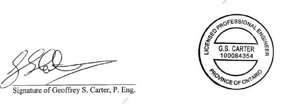
Geoffrey S. Carter, P. Eng.
Broad Oak
Associates
106,
Ribblesdale Drive
Whitby, Ontario
Canada L1N 7C2
| Energy Fuels Resources (USA) Inc. | |
| NI 43-101 Technical Review and Evaluation of the Exploration Potential of the Roca Honda Project | Page i |
Date and Signature Page
CERTIFICATE of AUTHOR
I, Geoffrey S. Carter P. Eng., do hereby certify that:
| 1 |
I am a Principal of: |
| 2. |
I graduated with an Honours Bachelor of Science (1968) degree in Mining Engineering from University of Wales, University College Cardiff, South Wales, UK in 1968 |
| 3. |
I am a retired member of the Professional Engineering Association of Manitoba, (5341) and I am a Professional Engineer in Ontario, (100084354). I am also a member of the Canadian Institute of Mining and Metallurgy. |
| 4. |
I have practiced my profession in excess of forty years. |
| 5. |
I have read the definition of “qualified person” set out in National Instrument 43-101 (“NI 43- 101”) and certify that by reason of my education and past relevant work experience, I fulfill the requirements to be a “qualified person” for the purposes of NI 43-101. This report is based on my personal review of information provided by the Issuer and on discussions with the Issuer’s representatives. My relevant experience for the purpose of this report is: |
| • |
Anglo American Corporation 1968-1983, Mine Engineer, General Mine Foreman, Hudson Bay Mining and Smelting Limited, Vice President Operations Inspiration Coal. | |
| • |
Senior Mining Engineer - Project Technical Evaluation Hudson Bay Mining and Smelting Co. Limited 1980-1981, Narrow Vein Resource Estimation, and Feasibility Studies | |
| • |
Mining Analyst, Midland Doherty, 1983-1986 | |
| • |
Author of several Technical Reports, 2002-2015 several including Resource Estimation, and Preliminary Economic Assessments |
| 6. |
I am responsible for the preparation of all sections of the technical report titled NI 43-101 Technical Report and Evaluation of the Exploration Potential of the Roca Honda Project, New Mexico, USA, dated March 4, 2016 (the Technical Report). I last visited the property on May 7, 2014. |
| 7. |
I have had prior involvement with the properties that are the subject of the Technical Report. I authored four previous technical reports which covered a portion of the properties that is the subject of this report. These reports were dated July 12, 2007, September 18, 2008, September 1, 2009, and October 29, 2014. |
| 8. |
As of the date of this certificate, to the best of my knowledge, information and belief, the technical report contains all scientific and technical information that is required to be disclosed to make the technical report not misleading. |
| Energy Fuels Resources (USA) Inc. | |
| NI 43-101 Technical Review and Evaluation of the Exploration Potential of the Roca Honda Project | Page ii |
| 9. |
I am independent of the issuer applying all of the tests in section 1.5 of National Instrument 43-101. |
| 10. |
I have read National Instrument 43-101 and Form 43-101F1, and the Technical Report has been prepared in compliance with that instrument and form. |
| 11. |
I consent to the filing of the Technical Report with any stock exchange and other regulatory authority and any publication by them for regulatory purposes, including electronic publication in the public company files on their websites accessible by the public, of the Technical Report. |
Dated March 4, 2016.
 | ||
| Seal or Stamp | ||
 | ||
Geoffrey S. Carter
Broad Oak Associates
106, Ribblesdale
Drive
Whitby, Ontario
Canada, L1N 7C2
Cell Tel. 416-452-3444
Tel: 416-594-6672
Email: BOA@Broadoak.ca
| Energy Fuels Resources (USA) Inc. | |
| NI 43-101 Technical Review and Evaluation of the Exploration Potential of the Roca Honda Project | Page iii |
| Date and Signature Page | i | |||
| Table of Contents | iii | |||
| Disclaimer | vii | |||
| 1 | Summary | 1 | ||
| Property Description | 1 | |||
| Ownership | 1 | |||
| History | 2 | |||
| Geology and Mineralization | 3 | |||
| Exploration Status | 3 | |||
| Mineral Resource Estimate | 4 | |||
| Environmental Liabilities | 4 | |||
| Permitting | 4 | |||
| Conclusions and Recommendations | 4 | |||
| 2 | Introduction | 7 | ||
| 2.1 | Terms of Reference and Purpose of the Report | 7 | ||
| 2.2 | Qualifications of Consultant (Broad Oak Associates) | 7 | ||
| 2.2.1 | Details of Inspection | 8 | ||
| 2.3 | Sources of Information and Data | 8 | ||
| 3 | Reliance on Other Experts (Item 3) | 9 | ||
| 3.1 | Effective Date | 9 | ||
| 3.2 | Units of Measure | 9 | ||
| 4 | Property Description and Location | 10 | ||
| 4.1 | Property Description and Location | 10 | ||
| 4.2 | Mineral Titles | 10 | ||
| 4.2.1 | Nature and Extent of Issuer’s Interest | 13 | ||
| 4.3 | Royalties, Agreements and Encumbrances | 14 | ||
| 4.4 | Environmental Liabilities and Permitting | 14 | ||
| 4.4.1 | Environmental Liabilities | 14 | ||
| 4.4.2 | Required Permits and Status | 14 | ||
| 4.5 | Other Significant Factors and Risks | 16 | ||
| 5 | Accessibility, Climate, Local Resources, Infrastructure and Physiography | 17 | ||
| 5.1 | Physiography | 17 | ||
| 5.2 | Climate and Vegetation | 17 | ||
| 5.3 | Accessibility | 17 | ||
| 5.4 | Local Resources | 17 | ||
| Energy Fuels Resources (USA) Inc. | |
| NI 43-101 Technical Review and Evaluation of the Exploration Potential of the Roca Honda Project | Page iv |
| 5.5 | Infrastructure Availability and Sources | 18 | ||
| 6 | History | 19 | ||
| 6.1 | Prior Ownership and Ownership Changes | 19 | ||
| 6.2 | Previous Exploration and Development Results | 19 | ||
| 6.2.1 | Kerr-McGee | 19 | ||
| 6.2.2 | Keradamex / Gulf Minerals | 20 | ||
| 6.2.3 | Conoco | 20 | ||
| 6.2.4 | Historical Exploration Data | 20 | ||
| 6.3 | Historic Mineral Resource and Reserve Estimates | 21 | ||
| 6.3.1 | Dames and Moore, 1979 | 22 | ||
| 6.3.2 | Douglas International, Inc., 1996 | 24 | ||
| 6.3.3 | Uranium Resources, Inc., 1996 | 25 | ||
| 6.3.4 | Uranium Resources, Inc., 2007-2008 | 25 | ||
| 6.4 | Historic Production | 28 | ||
| 7 | Geological Setting and Mineralization | 29 | ||
| 7.1 | Geology and Stratigraphy | 29 | ||
| 7.1.1 | Regional Geology | 29 | ||
| 7.1.2 | Local and Property Geology | 31 | ||
| 7.2 | Structure | 36 | ||
| 7.2.1 | Regional Structure | 36 | ||
| 7.2.2 | Project Area Structure | 36 | ||
| 7.3 | Mineralization | 38 | ||
| 7.3.1 | Roca Honda Project Mineralization | 38 | ||
| 7.3.2 | Controls on Mineralization | 40 | ||
| 7.3.3 | Mineralogy | 41 | ||
| 8 | Deposit Type | 42 | ||
| 9 | Exploration | 43 | ||
| 9.1 | Relevant Exploration Work | 43 | ||
| 9.2 | Exploration Potential | 43 | ||
| 9.2.1 | Southwest Section 11 | 45 | ||
| 9.2.2 | South Section 3 | 46 | ||
| 10 | Drilling | 48 | ||
| 10.1 | Type and Extent | 48 | ||
| 10.2 | Procedures | 48 | ||
| 11 | Sample Preparation, Analysis and Security | 50 | ||
| 11.1 | Historical Sampling Methods | 50 | ||
| 11.1.1 | Gamma Logging | 50 | ||
| Energy Fuels Resources (USA) Inc. | |
| NI 43-101 Technical Review and Evaluation of the Exploration Potential of the Roca Honda Project | Page v |
| 11.2 | QA/QC Procedures | 51 | ||
| 11.3 | Disequilibrium | 51 | ||
| 11.4 | Opinion on Adequacy | 52 | ||
| 12 | Data Verification | 53 | ||
| 13 | Mineral Process and Metallurgical Testing | 54 | ||
| 14 | Mineral Resource Estimate | 55 | ||
| 15 | Mineral Reserve Estimate | 56 | ||
| 16 | Mining Methods | 57 | ||
| 17 | Recovery Methods | 58 | ||
| 18 | Project Infrastructure | 59 | ||
| 19 | Market Studies | 60 | ||
| 20 | Environmental Studies, Permitting and Social or Community Impact | 61 | ||
| 21 | Capital and Operating Costs (Item 21) | 62 | ||
| 22 | Economic Analysis (Item 22) | 63 | ||
| 22.1 | Royalties | 63 | ||
| 23 | Adjacent Properties (Item 23) | 64 | ||
| 24 | Other Relevant Data and Information (Item 24) | 66 | ||
| 25 | Interpretation and Conclusions (Item 25) | 67 | ||
| 25.1 | Significant Risks and Uncertainties | 67 | ||
| 25.1.1 Exploration | 67 | |||
| 25.1.2 | Mineral Resource Estimate | 67 | ||
| 25.1.3 | Foreseeable Impacts of Risk | 68 | ||
| 26 | Recommendations | 69 | ||
| 27 | References | 71 | ||
| 28 | Glossary | 74 | ||
| 28.1 | Mineral Resources | 74 | ||
| 28.2 | Abbreviations | 74 | ||
| Energy Fuels Resources (USA) Inc. | |
| NI 43-101 Technical Review and Evaluation of the Exploration Potential of the Roca Honda Project | Page vi |
List of Tables
| Table 4-1. | Roca Honda Project Mineral Ownership | 10 |
| Table 4-2. | Summary of Major Permits for Future Mining | 15 |
| Table 6-1. | Historical Drilling Operations and Drill Data Owned by URI | 21 |
| Table 6-2. | Reserve Estimate, Dames and Moore, 1979, Section 17, T13N R8W | 22 |
| Table 6-3. | Mineable Ore Reserve, Dames and Moore, 1979, Section 17, T13N R8W | 22 |
| Table 6-4. | Reserve Estimate, Douglas International, Inc., 1996, Section 17, T13N R8W | 25 |
| Table 6-5. | Reserve Estimate, Uranium Resources, Inc., 1996, Section 17, T13N R8W | 25 |
| Table 6-6. | Resource Estimate, Uranium Resources, Inc. 2007, Section 17, T13N R8W | 26 |
| Table 9-1. | Notable mineralization intercepts drilled by Conoco in Section 11, T13N R8W. | 45 |
| Table 10-1. | Historical Drilling Operations and Drill Data Owned by URI | 48 |
| Table 26-1. | Estimated cost for Three Phase Work Program for Roca Honda Project. | 70 |
List of Figures
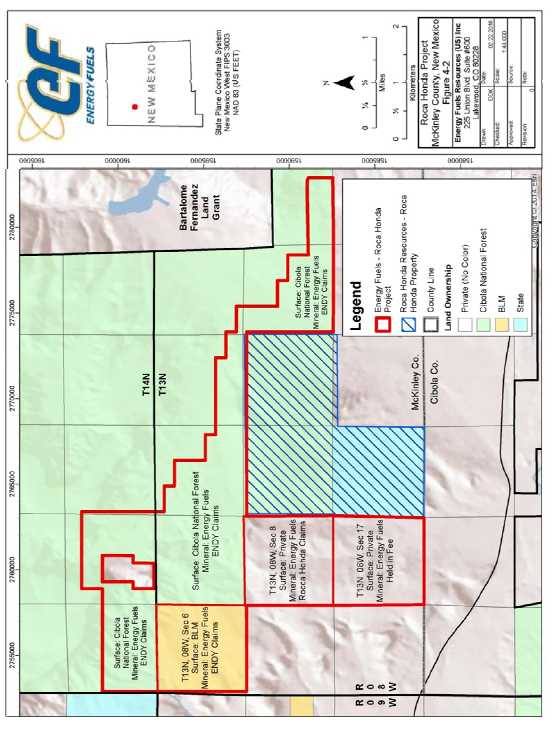
| Figure 4-1. | Location of Roca Honda project. | 11 |
| Figure 4-2. | Roca Honda project land holdings. | 12 |
| Figure 4-3. | Roca Honda and Roca Honda Project Ownership Structure | 14 |
| Figure 6-1. | Scan of Table 1, from Dames and Moore (1979) | 23 |
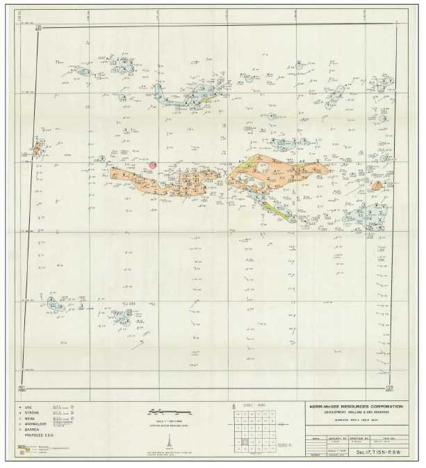
| Figure 6-2. | Kerr-McGee Drill Hole and Resource Map for Section 17, T13N R8W dated January 1979. | 24 |
| Figure 6-3. | URI rework of historical circle-tangent resource for Section 17 113N R8W in 2008. | 27 |
| Figure 7-1. | Regional geology map for the Grants Uranium District. | 30 |
| Figure 7-2. | Geology of the Roca Honda Project area. | 34 |
| Figure 7-3. | General stratigraphic column for the Grants Uranium District. | 35 |
| Figure 7-4. | Structural geology of Section 17 T13N R8W as mapped on the surface of the Dakota Sandstone (Kd) | 37 |
| Figure 7-5. | Generalized uranium mineralization trends in the Roca Honda project area. | 39 |
| Figure 9-1. | Exploration potential of the Roca Honda project. | 44 |
| Figure 9-2. | Polygons generated from historical drill holes in Section 11 T13N R8W by EFR staff | 46 |
| Figure 23-1. | Mines and development projects located in the vicinity of the Roca Honda project. | 65 |
Appendices
Appendix A Mineral Claims
| Energy Fuels Resources (USA) Inc. | |
| NI 43-101 Technical Review and Evaluation of the Exploration Potential of the Roca Honda Project | Page vii |
Disclaimer
This Report was prepared using Mineral Resources and Mineral Reserves definitions set out in accordance with the Canadian Institute of Mining, Metallurgy and Petroleum 2010 Definition Standards, and has been prepared in the format of a Technical Report following the item headings and content requirements in Canadian National Instrument 43-101 F1.
| Energy Fuels Resources. (USA) Inc. | |
| NI 43-101 Technical Review and Evaluation of the Exploration Potential of the Roca Honda Project | Page 1 |
| 1 |
Summary |
This Technical Report covering the Roca Honda uranium project was prepared for Energy Fuels Resources (USA) Inc. (referred to as either “EFR” or “The Company”), a Lakewood, Colorado-based uranium development company, a subsidiary of Energy Fuels Inc (“EFI”) whose securities are publically traded on the US NYSE Capital market under the symbol “UUUU”, and on the T.S.E. Canada Under the symbol EFR. The purpose of the report is to set forth, in a comprehensive manner, the technical details of the Roca Honda project, an analysis of the technical aspects and potential merits of the project, and to recommend additional work to further address aspects of the project that require further study.
The majority of this report is based on the historical documentation amassed by EFR and predecessor Uranium Resources Inc. (“URI”) that pertains to the Roca Honda project. This information includes drill hole logs, cross sections, maps, laboratory reports, and internal memos and reports from the numerous historical operators within the project area.
At this time EFR has not undertaken any exploration work at the Roca Honda project, and therefore this report is limited to a review of historical data and evaluation of the exploration potential of the project. This report does not present a NI 43-101 compliant resource for the Roca Honda project. Although several historical resource estimates are discussed, they are non-compliant, and should not be relied upon by the reader in any fashion.
Property Description
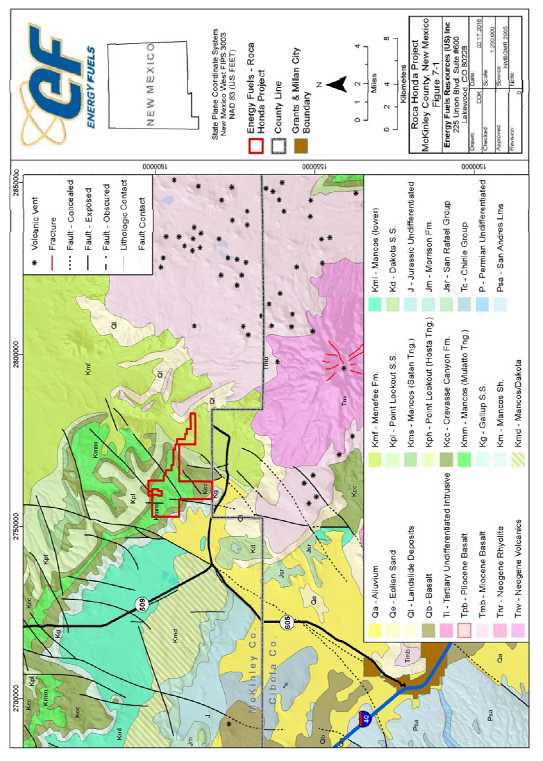
The Roca Honda project is located to the northwest of Mt Taylor, approximately 25 miles from the town of Grants, to the west and north of the village of San Mateo in McKinley County, New Mexico. The project area consists of multiple federal unpatented claims and mineral estate ownership within Townships 13 and 14 North, Range 8 West, New Mexico Principal Meridian.
The project area is located within San Mateo Valley sub-district of the Grants Uranium District in the southern San Juan Basin.
Ownership
The project area consists of approximately 4,320 acres of public and private land holdings, consisting of one section of private mineral and surface (Sections 17, T13N R8W – EFR does not own the surface); and 203 Federal Unpatented Lode Mining Claims on BLM Land, Cibola National Forest Land, and private surface (all or portions of Sections 2, 3, 4, 5, 6, 8, 11, and 12, all in T13N R8W and Sections 31 and 32, T14N, R8W).
All project area lands were purchased by Strathmore Resources (US) Ltd., an EFR-affiliated subsidiary of EFI ion July 31, 2015 and are held by Strathmore. Mineral rights for Section 17 were acquired from URI who had acquired it as part of their acquisition of Uranco Inc. [then a subsidiary of Santa Fe Pacific Gold Corporation (Santa Fe)]. Federal unpatented mining claims are either staked by a URI subsidiary, or leased from Enerdyne Endy Claims LLC through a long term lease agreement with Neutron Energy Inc. (“NEI”), all of which have been assigned to Strathmore.
| Energy Fuels Resources. (USA) Inc. | |
| NI 43-101 Technical Review and Evaluation of the Exploration Potential of the Roca Honda Project | Page 2 |
The surface rights over the Roca Honda project are a combination of Cibola National Forest (NF), the US Bureau of Land Management (BLM), and the privately held Fernandez Company Ranch (Fernandez). The use of the private surface held by Fernandez is governed by a 1979 Surface Use Agreement (SUA) between Santa Fe and Fernandez that includes Section 17, T13N R8W.
History
The Roca Honda project has a lengthy history with multiple historical exploration and development companies dating back to the mid-1950s.
Initial exploration and development on Sections 5, 6, 8 and 17 was completed by Kerr-McGee (Section 17 as a farm-out from Santa Fe) in the mid-1960s. Sections 11 and 12 were explored by Conoco up until 1981 after purchase from Homestake in the early 1970s. In addition, there is other historical drilling activity on other off trend land in the project area that cannot be attributed to a specific operator at this time due to a lack of records.
Kerr-McGee completed significant exploration and development work in sections 3, 4, 5, 6, 8, 9, 10, 16, and 17 T13N R8W from the mid-1960s until 1982. The land position on Section 17 was leased from Santa Fe during this time. Of the historical Kerr-McGee land position, EFR currently controls Sections 3, 4, 5, 6, 8 and 17, while Roca Honda Resources LLC (Energy Fuels Inc. 60%, Sumitomo Corp 40%) currently controls Sections 9, 10, and 16. During the course of their work program, Kerr-McGee drilled approximately 1,200 drill holes across the 3,840 acres they controlled on Sections 5, 6, 8, 9, 10, 16, and 17, and an unknown number of drill holes on Sections 3 and 4. This includes 917 drill holes advanced on Sections 5, 6, 8, and 17 controlled by EFR today. Kerr-McGee advanced the project far enough along to complete a feasibility study for what they had named the Lee Mine. In 1981 Kerr-McGee began construction of the Lee Mine with the advancement of a 14ft diameter shaft in the NE ¼ of Section 17. Unfortunately the project was abandoned prior to completion of the shaft due to declining uranium market conditions. The shaft penetrated into the Westwater Canyon Formation, but did not reach the total planned depth. The shaft was sealed at the surface in 1982, and no further work was completed.
Conoco’s land position in the area was acquired in the early 1970s, a portion of which was purchased from Homestake, and included Sections 2, 11, and 12 T13N R8W. Initial exploration was completed by drilling north-south fences on Section 2 and into Section 11. Activities were limited to minimal assessment drilling until 1979, until the major discovery and development work by Kerr-McGee directly to the west of Conoco’s land position at the Lee Mine. Conoco then refocused drilling on the western half of Section 11, intercepting uranium mineralization of significant grade and thickness. Drilling continued until 1981, extending the mineralization trend from Section 10 across the southwest quarter of Section 11.
URI gained control of Sections 17 in 1997 as part of the acquisition of the Uranco Inc. properties in New Mexico. Section 8 was procured through staking of new claims (Roca Honda Claims) in 1997. This was the extent of the land position that URI held in the project area from 1996 through 2012, for a total at the time of 2,664 non-contiguous acres.
The rest of the project area (positions in Sections 2, 3, 4, 5, 6 11, 12 T13N R8W) was obtained by the Company through URI’s acquisition of NEI in 2012. EFR acquired the URI land position in July 2015.
| Energy Fuels Resources. (USA) Inc. | |
| NI 43-101 Technical Review and Evaluation of the Exploration Potential of the Roca Honda Project | Page 3 |
Geology and Mineralization
The Roca Honda project is located in the southeast part of the Ambrosia Lake Sub-district of the Grants Uranium District, and located near the boundary of the Chaco Slope and Acoma Sag regional tectonic features. The Ambrosia Lake Sub-district resides in the southeastern Colorado Plateau physiographic province and within the southern flank of the San Juan Basin.
The San Juan Basin is truncated to the south and east of the project area by the Neogene volcanic rocks of the Mt. Taylor volcanic field, capping both Mesa Chivato and Horace Mesa. Bounding the basin to the southwest is the Zuni uplift, exposing rocks as old as Precambrian. On the Chaco slope, the predominantly Mesozoic strata dip to the north into the central San Juan Basin. The bounding structures of the San Juan Basin were formed largely during the Laramide Orogeny, extending from the Late Cretaceous through Eocene time.
The Morrison Formation, containing the Recapture Member, Westwater Canyon Member, and Brushy Basin Member in ascending order, outcrops near the southern edge of the San Juan Basin and dips northward into the basin. Between the Jurassic sediments and the overlying Late Cretaceous units is an erosional unconformity. The units overlying the unconformity in ascending order are Dakota Sandstone, Mancos Shale, Gallup Sandstone, Crevasse Canyon Sandstone, Point Lookout Sandstone, and Menefee Formation. The Gallup Sandston, Crevasse Canyon Sandstone Point Lookout Sandstone, and Menefee Formation compose the Mesaverde Group.
The primary host of uranium ore within the region is the Westwater Canyon Member of the late Jurassic Morrison Formation, with some localized mineralization occurring within the Poison Canyon Sandstone of the Brushy Basin Member. Regionally these sandstone deposits have been interpreted as forming on the distal portion of an alluvial fan. Braided streams originating in the mountains to the west and southwest carrying clasts of Precambrian granites, Paleozoic chert, metamorphic rocks, and other material deposited the ore-bearing channel sands. Interbedded shales were deposited in flood plains (lower energy environments), and fossil evidence also indicates some of the shales formed in local lacustrine environments.
The uranium mineralization found at the Roca Honda project is contained in elongate trends that vary from one foot to over 30ft in thickness, 100ft to 400ft in width, and 200ft to over 3,000ft in length. Mineralization trends runs from west to east, and northwest to southeast depending on general area within the project area. This trend of mineralization across the project area appears to be consistent with the fluvial sedimentary structures of the Westwater Canyon Member.
Uranium mineralization in the project area is believed to be predominantly trend ore, with some secondary mineralization due to oxidation and mobilization of uranium in the vicinity of permeable geologic structures. Almost all trend ore within the Grants Uranium District is intimately associated with humate material derived from the decay of plant and animal matter. In addition to the humate material, the uranium deposits may also contain enriched concentrations of vanadium, molybdenum, copper, selenium, and arsenic. The primary mineralization pre-dates the formation of the Laramide aged structures in the project area, with a small amount of vertical offset of mineralization present across the local faults.
Exploration Status
EFR has yet to complete any exploration activities at the Roca Honda project.
| Energy Fuels Resources. (USA) Inc. | |
| NI 43-101 Technical Review and Evaluation of the Exploration Potential of the Roca Honda Project | Page 4 |
The Company is in possession of an extensive exploration database gathered from historical operators of the project including drill hole data, geophysical logs, maps, laboratory data, and internal memos and reports.
Mineral Resource Estimate
There is no NI 43-101 compliant mineral resource estimate for the Roca Honda project.
Numerous owners and operators have completed exploration and development activities in the project area, and have completed resource estimates of a historical nature. These historical resource estimates are not to be considered equivalent to current mineral resources or mineral reserves as defined in NI 43-101. The historical estimates cannot, and should not, be relied upon.
Environmental Liabilities
Previous mining activities within the Roca Honda project were limited to exploration and resource delineation drilling, as well as shaft construction on Section 17. The historical operators of the project reclaimed the land as required, and it was released back into the public domain or to the private surface owners care.
EFR has not completed any ground disturbing activities in the project area to date. There are no current reclamation liabilities associated with the project.
Permitting
EFR has no permit applications for exploration or mining activities in review with regulatory agencies at this time. Neutron Energy Inc. (NEI) submitted a Plan of Operations to the USFS in 2009 for exploration drilling in Sections 11,3,5,6 and 31 but the application has been on hold for several years.
The historical mineral resources of the Roca Honda project reside in a mixed land owner area including privately held ranchlands, as well as public lands administered by the BLM and USFS. As such, the requirements of the BLM and USFS would likely dictate permitting requirements and timeframes unless development was limited to privately held surface areas. In addition, any development activities would require application to the State of New Mexico Mining and Minerals Division (NMMMD) to obtain Exploration or Mine Permits. Exploration permit(s) will be required to complete data collection activities (hydrogeology, geotechnical) as well as resource confirmation, prior to application for a mine permit.
Conclusions and Recommendations
The Roca Honda project presents a potentially significant uranium resource located amongst known and defined projects including some of the largest and highest grade economic uranium deposits in the United States.
Historic, noncompliant resource estimates from previous operators suggest that Section 17 T13N R8W contains a multi-million pound uranium deposit. In addition, there are numerous indications of open ended trends that present substantial upside prospects to expand the potential mineral resources of the Roca Honda project. A full and modern analysis and interpretation is required to confirm the historical data, advance the geologic understanding, and progress the project. Additional subsurface data collection, including core samples for laboratory analysis, are required for development of a NI 43-101 compliant resource estimate for the Roca Honda project.
| Energy Fuels Resources. (USA) Inc. | |
| NI 43-101 Technical Review and Evaluation of the Exploration Potential of the Roca Honda Project | Page 5 |
Broad Oak Associates recommends that EFR continue to review, analyze, and interpret the historical data, and develop new data, in order to develop NI 43-101 compliant resource estimate for the Roca Honda project. The following recommendations are provided in a phased approach.
Phase I
| o |
Review and reinterpret lithology and uranium mineralization from all historical drill logs. This work should include completing the digitization of the historical data and creation of a database to archive/manage the data. | |
| o |
Complete geologic and resource models of the Roca Honda project from the historical data. Models should focus on stratigraphic and structural interpretations, and continuity of mineralization. Resource estimates should be completed through use of modern 3D geostatistical analysis, rather than the historical geometric methods. | |
| o |
Complete new wholistic interpretations of the Roca Honda project and develop a drill plan with the following goals: |
| • | Confirm historical mineralization; | |
| • | Test potential areas for resource expansion; and, | |
| • | Sample collection for chemical assay, disequilibrium studies, and rock density testing in as many mineralized zones as possible. |
Phase II
| o | Update Surface Access Agreement with Fernandez and Co. | |
| o | Complete necessary environmental work necessary to permit the drill plan, most notably cultural resource surveys over Section 17, some surveys have been completed | |
| o | Permit the drill plan with the State of New Mexico and USFS as necessary. |
Phase III
| o | Complete the drilling, sample collection, and analysis scoped in Phase I | |
| o | Complete interpretation of the new data from the drilling program, integrate with the historical data and adjust project interpretations as necessary. | |
| o | Utilize historical and new project data to develop new mineral resource estimates that are NI 43-101 compliant. | |
| o | Complete NI 43-101 Technical Report with compliant resources for Sections 11 and 17 of the Roca Honda Project. |
| Energy Fuels Resources. (USA) Inc. | |
| NI 43-101 Technical Review and Evaluation of the Exploration Potential of the Roca Honda Project | Page 6 |
| Proposed Program | Estimated Cost (USD) | ||
| Phase I | |||
| Digitize historical drill data and geophysical logs | 10,000 | ||
| Development of a historical drill hole database, with reinterpretation of historical drill logs | 20,000 | ||
| Geologic Model | 20,000 | ||
| Resource Model (historical data) | 30,000 | ||
| Develop Drill Plan | 20,000 | ||
|
Phase I Subtotal |
$ | 100,000 | |
| Phase II | |||
| Renegotiate Surface Use Agreement with
Fernandez and Co. to include full project area as needed for |
Unknown | ||
| Environmental and Cultural Survey work to clear Sections 11, and 17 | 50,000 | ||
| Drill Program Permitting with NMMMD and USFS | 120,000 | ||
|
Phase II Subtotal |
$ | 170,000 | |
| Phase III | |||
| Drill Program Field Work (assume 20
drill holes, of which 4 are core holes, as well as associated supporting activities. |
1,500,000 | ||
| Analytical Program | 120,000 | ||
| Update Geologic and Resource Models | 30,000 | ||
| Consulting Services for
completion of a NI 43-101 Technical Report with Compliant Resources for Sections 11 and 17, T13N R8W |
40,000 | ||
|
Phase III Subtotal |
$ | 1,690,000 | |
|
Grand Total |
$ | 1.960,000 |
Broad Oak Associates anticipates that the work program scoped above would require approximately 2 to 3 years to complete. The estimated budget for the program is US$2 M with the majority of costs falling in Phase III, in addition there is one work program item for which costs cannot be estimated due to transactional relationships with third parties that cannot be quantified at this time.
| Energy Fuels Resources. (USA) Inc. | |
| NI 43-101 Technical Review and Evaluation of the Exploration Potential of the Roca Honda Project | Page 7 |
| 2 |
Introduction |
| 2.1 |
Terms of Reference and Purpose of the Report |
This Technical Report covering the Roca Honda uranium project was prepared for Energy Fuels Resources (USA) INC.(referred to as either “EFR” or “The Company”), a Denver, Colorado-based uranium development company, a subsidiary of Energy Fuels Inc (“EFI”), whose securities are publically traded on the New York Capital market under the symbol “UUUU” or The Toronto Stock Exchange under the symbol EFR. The purpose of the report is to set forth, in a comprehensive manner, the technical details of the Roca Honda project, an analysis of the technical aspects and potential merits of the project, and to recommend additional work to further address aspects of the project that require further study.
There are references to Strathmore and it is a wholly-owned subsidiary of the Company.
This report was prepared as a National Instrument 43-101 (NI 43-101) Technical Report for EFR by the Author, Geoffrey S. Carter of Broad Oak Associates who meets the definition of Qualified Person under NI 43-101.
The quality of information, conclusions, and estimates contained herein is consistent with the level of effort involved in the consultant’s services, based on: i) information available at the time of preparation, ii) data supplied by outside sources, and iii) the assumptions, conditions, and qualifications set forth in this report. This report is intended for use by EFR, as EFR sees fit, which would include the filing of this report as a Technical Report with Canadian Securities Regulatory Authorities pursuant to NI 43-101, Standards of Disclosure for Mineral Projects, should EFR (a New York listed company) have a reason to do so. Except for the purposes intended, any other use of this report by any third party is at that party’s sole risk. The responsibility for any disclosure of this report remains with EFR. The user of this document should ensure that this is the most recent Technical Report for the property as it is not valid if a new Technical Report has been issued.
This report includes technical information, which required subsequent calculations to derive subtotals, totals and weighted averages. Such calculations inherently involve a degree of rounding and consequently introduce a margin of error. Where these occur, the Consultant does not consider them to be material.
| 2.2 |
Qualifications of Consultant (Broad Oak Associates) |
The consultant preparing this report is a specialist in the fields of uranium geology, exploration, and mineral resource estimation.
The Consultant involved in the preparation of this report has no beneficial interest in EFR, its affiliated subsidiary companies, or the Roca Honda project. The Consultant is not an insider, associate, or affiliate of EFR. The results of the Technical Report are not dependent upon any prior agreements concerning the conclusions to be reached, nor are there any undisclosed understandings concerning any future business dealings between EFR and the Consultant. The Consultant is being paid a fee for their work in accordance with normal professional consulting practice.
The author, Geoffrey S. Carter, by virtue of his education, experience, and professional association, is considered a Qualified Person (QP) as defined in the NI 43-101 standard, for this report, and is a member is good standing of appropriate professional institutions. The QP is responsible for all content of this Technical Report.
| Energy Fuels Resources. (USA) Inc. | |
| NI 43-101 Technical Review and Evaluation of the Exploration Potential of the Roca Honda Project | Page 8 |
| 2.2.1 |
Details of Inspection |
Geoffrey S. Carter conducted a site visit to the Roca Honda project for URI on May 7, 2014. The site inspection included a review of historical drill sites, the existing partially complete production shaft, and general project location, access, and infrastructure. There has been no physical work carried out at the site since that visit except that EFR has completed baseline surveys within sections 17 and 8 as described in section 20.
| 2.3 |
Sources of Information and Data |
EFR, and predecessor URI and its employees and subcontractors organized, developed, and collected most of the information used to evaluate the Roca Honda Project. Information provided by the Company consisted of historical drill holes data, historical operator reports, drill maps, and historical mineral resource estimations. All of the additional data utilized in this report has been sourced from the public sector, either in published journals or data from public institutions such as federal and state geological surveys and state mining agencies. All information provided by EFR to Broad Oak Associates was qualitatively evaluated, and only that information which was deemed to be of acceptable content, detail, and accuracy were used to formulate the basis of the project assessment and exploration potential. The data and information appears to be of quality to accurately portray the technical attributes of the project and is considered to be suitable for technical analysis by current industry standards.
Matt Hartmann, Manager – Development Geology for URI was a contributor to the previous report. He is a Licensed Professional Geologist in the States of Wyoming (3589) and Texas (11705), a registered member of SME (4170350RM), and a Qualified Person as defined by National Instrument 43-101. He has more than 12 years of experience in mineral exploration and development, much of which is in the uranium industry. Mr. Hartmann has worked extensively with the uranium deposits of the San Mateo Valley, including management of the development drilling completed by Roca Honda Resources LLC in 2007-2008 directly adjacent to the Roca Honda project on Section 16, T13N R8W while under the employ of Strathmore Resources (US) Ltd. He provided guidance during the recent site visit, and much discussion on the geology of the uranium deposits of the Roca Honda project and the San Mateo Valley. He has contributed to the text in many sections of this report; however, the author takes full responsibility for the entire report. Two geologists employed by EFR assisted in reviewing the technical and scientific content of the report for completeness and accuracy: Richard White Chief Geologist CPG #08792 and Dan Kapostasy Registered Member of SME, #417223RM, who worked on the adjacent RHR LLC project for 6 years as an employee of Strathmore and 2.5 years with EFR.
The sources of information include data and reports supplied by EFR, URI as well as documents referenced in Section 27.
| Energy Fuels Resources. (USA) Inc. | |
| NI 43-101 Technical Review and Evaluation of the Exploration Potential of the Roca Honda Project | Page 9 |
| 3 |
Reliance on Other Experts |
The historical data was collected by the geological and engineering staffs of the companies that previously operated exploration, development and mining operations on the lands that comprise the Roca Honda project area. The former operating companies, Kerr-McGee, Santa Fe, Conoco, Keradamex, and Gulf Minerals each had extensive experience in the exploration for and the development of sandstone-hosted uranium deposits in the western United States.
The author of this report has reviewed significant portions of the historical database relating to the Roca Honda project, and has concluded that the data is in appropriate form and utilized technical methods that were generally employed by the United States uranium exploration and mining industry at the time the information was collected, and that data is valid today for use in future resource estimation.
The author relied upon EFR for the discussion in Section 3 on Mineral Titles and Environmental issues. The extent of that reliance is the summary of the land title, as provided by EFR, which is presented in Section 3.
The author used their experience to determine if the information from historical reports was suitable for inclusion in this technical report. This report includes technical information, which required subsequent calculations to derive subtotals, totals and weighted averages. Such calculations inherently involve a degree of rounding and consequently introduce a margin of error. Where these occur, the author does not consider them to be material.
| 3.1 |
Effective Date |
The effective date of this report is February 15, 2016.
| 3.2 |
Units of Measure |
The imperial system has been used throughout this report. Tons are equivalent to 2000 pounds. All currency is in U.S. dollars (US$) unless otherwise stated.
Imperial units of measure are used in this report, and match the units in which all existing data was historically collected. Uranium resources and production are commonly referenced in terms of pounds of U3O8 rather than tons (or tonnes) and this report follows that convention. Uranium grades are expressed as % eU3O8, which is an “equivalent” grade determined from radiometric assaying, or % cU3O8, which is an expression of a chemical assay most commonly determined by the fluorimetricanalytical method, and used by the former operators of the project.
| Energy Fuels Resources. (USA) Inc. | |
| NI 43-101 Technical Review and Evaluation of the Exploration Potential of the Roca Honda Project | Page 10 |
| 4 |
Property Description and Location |
This section addresses the project land holdings, corporate agreements, existing environmental liabilities and the permitting process.
| 4.1 |
Property Description and Location |
The Roca Honda project is located to the northwest of Mt Taylor, approximately 25 miles from the town of Grants, to the west and north of the village of San Mateo in McKinley County, New Mexico. The project area consists of multiple federal unpatented claims and mineral estate ownership within Township 13 and 14 North, Range 8 West, New Mexico Principal Meridian. A project location map is shown in Figure 4-1.
The project area is located within the Ambrosia Lake Sub-district of the Grants Uranium District in the southern San Juan Basin.
| 4.2 |
Mineral Titles |
This discussion of EFR’s property holdings within the Roca Honda project refers to certain legal issues and proceedings. The author is not a qualified person with respect to legal matters. The author believes EFR’s property holdings are stated herein, but this is not a legal title opinion.
The property comprises 4,320 acres of public and private land holdings consisting of one section of private mineral and surface (Section 17, T13N, R8W; the Company owns the minerals, but not the surface of the 622 acres in this section), and 203 unpatented lode claims on BLM Land, Cibola National Forest Land, and private surface in all or part of Sections 2, 3, 4, 5, 6, 8, 11, and 12, T13N, R8W, and Sections 31 and 32, T14N, R8W. The Company owns the claims in Section 8 (36 claims-623 acres) and holds all others (167 claims- 3,076 acres) as lessee, by assignment, of a Mineral Lease Agreement with Enerdyne Endy Claims LLC.
A full list of the EFR Federal unpatented lode mining claims re this project are listed in Appendix B. The breakdown of mineral ownership is shown in Table 4-1, and Figure 4-2.
Table 4-1. Roca Honda Project Mineral Ownership
| Method of Ownership | Sections
(Twn & Rng) |
Number of
Claims |
Acreage | |
| EFI simple fee mineral, acquired
from Uranco Inc. (Santa Fe) |
17 (T13N, R8W) |
N/A | 622 | |
| Federal Unpatented Lode
Mining Claims |
Hydro Resources Inc. (HRI)
(Roca Honda Claims) |
8 (T13N, R8W) |
36 | 623 |
| Lease agreement with Enerdyne Endy Claims LLC (Endy Claims) |
All or Portion of Sections 2,3,4,5,6,11,12 (T13N, R8W) and 31&32(T14N R8W) |
167 | 3,075 | |
| Total | 4,320 | |||
| Energy Fuels Resources. (USA) Inc. | |
| NI 43-101 Technical Review and Evaluation of the Exploration Potential of the Roca Honda Project | Page 11 |
Figure 4-1. Location of Roca Honda project.
![]()
| Energy Fuels Resources. (USA) Inc. | |
| NI 43-101 Technical Review and Evaluation of the Exploration Potential of the Roca Honda Project | Page 12 |
Figure 4-2 Roca Honda project land holdings
| Energy Fuels Resources. (USA) Inc. | |
| NI 43-101 Technical Review and Evaluation of the Exploration Potential of the Roca Honda Project | Page 13 |
Surface Rights
The surface rights over the Roca Honda project are a combination of Cibola National Forest (NF), the US Bureau of Land Management (BLM), and the privately held Fernandez Co.
Use of the surface of the project area is subject to a permitting process with the BLM, Cibola NF, and the State of New Mexico. In New Mexico, exploration work is completed under a Minimal Impact Exploration Permit that limits disturbance to 5 acres, or a Regular Exploration Permit. The level of study required before a permit is issued depends on the number of acres that will be disturbed, and whether sensitive ecological or archaeological sites are known to exist in the project area. A Plan of Operations is also required by the USFS or BLM for exploration activities on lands under their jurisdiction.
The use of the private surface held by Fernandez Company Ltd. (Fernandez) is governed by a 1979 Surface Use Agreement (SUA) between Santa Fe and Fernandez that includes Section 17 of T13N R8W.
Previous mining disturbance in the Roca Honda Project consists of an uncompleted shaft constructed in the northeast quarter of Section 17, and a historical building that supported shaft construction. The surface facilities were turned over to the surface owner (Fernandez) when Kerr-McGee abandoned the project in 1982. The shaft was not reclaimed, it is currently open at depth and capped with a concrete seal.
Annual Obligations
Obligations that must be met to retain the property include annual payment of claim maintenance fees to the BLM at a rate of US$155 per claim, per year; as well as nominal annual recording fees with McKinley County Clerk’s office. These rates are current as of 2016. In addition to the payments to the federal and local government, EFR has financial obligations related to the acquisition of the Endy claim package. The Endy claim package that includes claims in addition to those within the Roca Honda project, requires an annual advance royalty payment of US$75,000 as well as assumption of the annual claim maintenance fee obligations.
EFI’s SUA with Fernandez does not require any annual payments at the time of this report, with commitments limited to a gross value royalty.
Patented Claims
The Roca Honda project does not contain any patented Federal mining claims.
| 4.2.1 |
Nature and Extent of Issuer’s Interest |
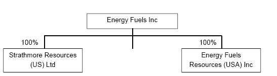
EFI holds the all rights to the Roca Honda project through wholly owned subsidiary, Strathmore, who is successor of interest to Neutron Energy Inc. (Enerdyne Endy Claim LLC Endy claim package lease) successor of interest to Hydro Resources Inc. (Roca Honda claims on Section 8), and successor of interest to Uranco (fee minerals on Section 17). EFR’s ownership interest in these business entities that hold title to the Roca Honda project is depicted in Figure 4-3.
| Energy Fuels Resources. (USA) Inc. | |
| NI 43-101 Technical Review and Evaluation of the Exploration Potential of the Roca Honda Project | Page 14 |
Figure 4-2. Roca Honda and Roca Honda Project Ownership Structure
| 4.3 |
Royalties, Agreements and Encumbrances |
Royalties on the Roca Honda project vary across the holding. The Endy claim group has a 5% gross production royalty. All annual advanced royalties are credited against the production royalties.
The other royalty over the project area falls under the SUA with Fernandez. The terms of this SUA, originally drafted under previous owner Santa Fe, applies a 1% gross value royalty. This royalty applies to Section 17, T13N R8W.
Any eventual mine developed by EFR in the project area will be subject to a State of New Mexico effective severance tax of 3 ½% for yellowcake, and a conservation tax calculated at the time of sale. In addition, any development would be subject to state property and sales taxes, and federal income taxes.
| 4.4 |
Environmental Liabilities and Permitting |
| 4.4.1 |
Environmental Liabilities |
Previous mining activities within the Roca Honda project were limited to exploration and resource delineation drilling, and shaft construction on Section 17. The historical operators of the project reclaimed the land as required, and it was released back into the public domain or to the private surface owners care.
EFR has not completed any ground disturbing activities in the project area to date. There are no current reclamation liabilities associated with the project.
| 4.4.2 |
Required Permits and Status |
The mineral resources of the Roca Honda project reside in a mixed land owner area including privately held ranchlands, as well as public lands administered by the BLM and USFS. As such, the requirements of the BLM and USFS would likely dictate permitting requirements unless development was limited to privately held surface areas. In addition, any development activities would require application to the State of New Mexico Mining and Minerals Division (NMMMD) to obtain Exploration or Mine Permits. Exploration permit(s) will be required to complete data collection activities (hydrogeology, geotechnical) as well as resource confirmation, prior to application for a mine permit.
Table 4.2 lists the principal permits that will be needed to commence mining operations. To date, none of these permits applications are in development by EFR, although NEI submitted a Plan of Operations to the USFS for most of the project area in 2009.
| Energy Fuels Resources. (USA) Inc. | |
| NI 43-101 Technical Review and Evaluation of the Exploration Potential of the Roca Honda Project | Page 15 |
Table 4-2. Summary of Major Permits for Future Mining
| Regulatory Agency | Permit Name |
| Federal Permits | |
| United States Forest Service (Depending on Section) | • Approved Plan of Operations/Decision Record |
| • Roads and utility Right-of-Way | |
| Bureau of Land Management (Depending on Section) | • Approved Plan of Operations/Decision Record |
| • Roads and utility Right-of-Way | |
| Bureau of Alcohol, Tobacco, Firearms and Explosives | • Authorization to purchase, transport, store explosives |
| Environmental Protection Agency | • Hazardous Waste ID No. (small quantity generator) |
| State Permits | |
| New Mexico Mining and Minerals Division | Mine Permit |
| New Mexico Environment Department, Groundwater Quality Bureau | Groundwater Discharge Permit |
| New Mexico Environment Department, Air Quality Bureau | Construction and Operations Permit – Air |
| New Mexico Office of the State Engineer | Mine Dewatering Permit |
| Local Permits | |
| McKinley County | Building Permit, Business License |
Federal Permitting
A mine plan of operations (PoO) will need to be prepared to describe the construction, operation, reclamation, and closure of each facility along with a bond estimate that presents the reclamation and closure costs. Information that will need to be included in the PoO includes, pit/shaft location(s), lateral and vertical extent of surface disturbances, locations of access and haul roads, ore stockpiles, waste rock dumps, office/laboratory/shop buildings, water treatment plant, diesel/lubricant storage, landfill, water supply, dewatering pipelines, power lines and power distribution, schedule of construction and operation, mining schedule, and equipment lists. Reclamation of the proposed facility will dominate the content of the PoO, as this will be used to prepare the reclamation cost estimate for bonding purposes.
The PoO will need to supply sufficient detail in order to identify and disclose potential environmental issues during the mandatory National Environmental Policy Act (NEPA) review. This review will likely require the preparation of an environmental impact statement (EIS). An EIS acknowledges the potential for significant impact to occur, and analyzes and discloses the nature and potential extent of those impacts. It may be possible to amend the EIS currently being prepared for the adjacent Section 16 mine to include development drilling and new mine facilities in the project area.
In general, the PoO requires inclusion of at least one year of baseline environmental data from the project area. The collection of this data will need to be guided in part by the regulatory agency(s) involved to ensure that the information collected meet the Data Quality Objectives (DQOs) of the agency to support the impact assessment.
State Permitting
The state of New Mexico requires several permits for mining operations, the most significant of which is the Permit to Mine issued from the Mining and Minerals Division. The two major phases of the permit application are the Sampling and Analysis Plan (SAP), and the Mine Permit Application.
| Energy Fuels Resources. (USA) Inc. | |
| NI 43-101 Technical Review and Evaluation of the Exploration Potential of the Roca Honda Project | Page 16 |
The SAP describes the type, methods, and quality of data to be collected and analyzed for use in the Mine Permit Application. The data collection program directed through the SAP is nearly identical to the data required for the PoO submitted to the federal regulatory agencies and generally takes at least one full year to collect once certain infrastructure (weather station, monitor wells, etc.) are in place.
The Mine Permit Application encompasses the baseline data collected under the guidance of the SAP, as well as operational, reclamation, and closure plans for the proposed facility and is required regardless of the surface land owner.
In addition to the Mine Permit, several other significant permits are managed through the State of New Mexico, including the Groundwater Discharge Permit, Air Quality Permit for Construction and Mine Operations, and mine dewatering Permit. All have specific application requirements and require baseline data similar to that of the Mine Permit application, but focused on the specific permit topic area.
Local Permitting
Local permitting includes, but is not limited to various building permits, and a business license.
| 4.5 |
Other Significant Factors and Risks |
The author is not aware of any other significant risks or factors associated with development of the project at this time.
| Energy Fuels Resources. (USA) Inc. | |
| NI 43-101 Technical Review and Evaluation of the Exploration Potential of the Roca Honda Project | Page 17 |
| 5 |
Accessibility, Climate, Local Resources, Infrastructure and Physiography |
| 5.1 |
Physiography |
The Roca Honda project lies within an elevation range of 7,000 feet and 8,000 feet above mean sea level (amsl). The project area consists of low lying areas incised by arroyos and higher elevation mesas. There are no permanent flowing streams in the immediate area of the project; ephemeral streams carry debris downstream during infrequent summer storms and spring snowmelt runoff.
| 5.2 |
Climate and Vegetation |
Climate in the Roca Honda project may be classified as arid to semiarid continental, with cool, dry winters, and warm, dry summers. Abundant sunshine, large annual and diurnal temperature ranges, and low humidity are all characteristics of the local climate.
On average the project area receives approximately 11 inches of precipitation annually. The majority of the precipitation occurs during monsoonal storm events from July through September annually. Winter is generally the driest season with an average of only 13in. of snow. In general, the winter temperature range of the area will clear most snow quickly from all but the north facing and shaded slopes.
Grants, New Mexico has an average summer high of 87°F and a low of 52°F, and an average winter high of 47°F and a low of 18°F.
Flora is typical of the semi-arid, high altitude desert of New Mexico; juniper and piñon trees populate the high mesas, and native grasses and sagebrush are found in the lower lying regions.
| 5.3 |
Accessibility |
The Roca Honda project is located approximately 17 air miles, and 22 road miles north-northeast of Grants, New Mexico, and located along the southern boundary of McKinley County. The property can be reached by travelling north on New Mexico State Highway 605 from Milan towards the village of San Mateo. Access into the property from NM 605 is via numerous public (McKinley County, BLM, USFS) and private dirt roads. Access into certain project areas is subject to an existing surface use agreement with the private surface owner. Numerous historical drill roads and ranch roads cross the property, most of which are in need of repair.
| 5.4 |
Local Resources |
Grants, New Mexico located in Cibola County to the south of the project area is the largest community in the vicinity of the project area. As of the 2010 US Census, 8,722 people lived in Grants. There has been a long history of both open pit and underground mining in west central New Mexico, and it is believed that a capable workforce for a new mine could be sourced from the local population. Within 20 miles of the Roca Honda Project are two significant operating open cut coal mining projects owned by Peabody Energy – the Lee Ranch Mine, and the El Segundo Mine.
| Energy Fuels Resources. (USA) Inc. | |
| NI 43-101 Technical Review and Evaluation of the Exploration Potential of the Roca Honda Project | Page 18 |
| 5.5 |
Infrastructure Availability and Sources |
There is limited infrastructure related to historical operations within the Roca Honda project. A partially completed shaft exists in the northeast quarter of Section 17, and the remaining infrastructure is limited to existing drill roads of varying quality. High voltage power lines run across the northern extent of the project area and low voltage lines cross through Section 17. Water for drilling is generally sourced either in the town of Milan, or from local ranch wells. Dewatering for any future mine development will source a greater quantity of water than is required for ongoing operations.
| Energy Fuels Resources. (USA) Inc. | |
| NI 43-101 Technical Review and Evaluation of the Exploration Potential of the Roca Honda Project | Page 19 |
| 6 |
History |
| 6.1 |
Prior Ownership and Ownership Changes |
The Roca Honda project has a lengthy history with multiple historical exploration and development companies dating back to the mid-1950s.
Initial exploration and development on Sections 5, 6, 8 and 17 was completed by Kerr-McGee (Section 17 was a leased from Santa Fe) in the mid-1960s. Sections 11 and 12 were explored by Conoco up until 1981 after purchase from Homestake in the early 1970s. In addition, there is other historical drilling activity on other off trend land within the project area that cannot be attributed to a specific operator at this time due to a lack of records.
URI gained control of Sections 13, 15 and 17, T13N R8W in 1997 as part of the acquisition of the Uranco Inc. properties in New Mexico. Section 8 was procured through staking of new claims (Roca Honda Claims). This was the extent of the land position that URI held in the project area from 1996 through 2012, for a total at the time of 2,560 non-contiguous acres.
The rest of the project area (positions in Sections 2, 3, 4, 5, 6 11, 12 T13N R8W, 31, and 32 T14N R8W) was obtained by the Company through the URI acquisition of Neutron Energy Inc. (NEI) in 2012. The NEI land position in the project area consists of leased claims from Enerdyne Endy Claims LLC which were acquired by NEI in February 2006.
Then in 2014, URI divested itself of the Section 13 and 15 properties through a land trade with Rio Grande Resources Corp. in exchange for other property assets in Texas. The property that EFR purchased from URI in July 2015 did not include Sections 13 and 15.
| 6.2 |
Previous Exploration and Development Results |
Three major exploration programs occurred historically within the Company’s Roca Honda project.
| 6.2.1 |
Kerr-McGee |
Kerr-McGee completed significant exploration and development work Sections 3, 4, 5, 6, 8, 9, 10, 16, and 17 T13N R8W from the mid-1960s until 1982. The land position on Section 17 was leased from Santa Fe at the time. Of the historical Kerr-McGee land position, EFR currently controls Sections 3, 4, 5, 6, 8 and 17, while Roca Honda Resources LLC (Energy Fuels Inc. 60%, Sumitomo Corp 40%) currently controls Sections 9, 10, and 16. During the course of their work program, Kerr-McGee drilled approximately 1,200 drill holes across the 3,840 acres they controlled on Sections 5, 6, 8, 9, 10, 16, and 17, and an unknown number of drill holes on Sections 3 and 4. This included 917 drill holes on Sections 5, 6, 8, and 17 controlled by EFR today. Kerr-McGee advanced the project far enough along to complete a feasibility study for what they had named the Lee Mine. In 1981 Kerr-McGee began construction of the Lee Mine with the advancement of a 14ft diameter shaft in the NE ¼ of Section 17. Unfortunately the project was abandoned prior to completion of the shaft due to uranium market conditions. The shaft penetrated into the Westwater Canyon Formation, Member of the Morrison Formation,- to a total depth of 1,478 feet, but did not reach the total planned depth (1,655 feet). The shaft was sealed at the surface in 1982, and no further work was completed.
| Energy Fuels Resources. (USA) Inc. | |
| NI 43-101 Technical Review and Evaluation of the Exploration Potential of the Roca Honda Project | Page 20 |
| 6.2.2 |
Keradamex / Gulf Minerals |
Keradamex and Gulf Minerals completed exploration activities on Section 13 and 15 from 1968 to 1978. The land position was leased from Santa Fe. During that time 79 exploration drill holes were advanced on Section 13, and 59 exploration drill holes advanced on Section 15. Further development of Sections 13 and 15 was not completed, with Gulf Minerals focused on what would become the Mt. Taylor Mine just northeast of the village of San Mateo.
| 6.2.3 |
Conoco |
Conoco’s land position in the area was acquired in the early 1970s, a portion of which was purchased from Homestake, and included Sections 2, 11, and 12 T13N R8W. Initial exploration was completed by drilling north-south fences on Section 2 and into Section 11. Activities were limited to minimal assessment drilling until 1979, until the major discovery and development work by Kerr-McGee directly to the west of Conoco’s land position at the Lee Mine. Conoco then refocused drilling on the western half of Section 11, intercepting uranium mineralization of significant grade and thickness. Drilling continued until 1981, extending the mineralization trend from Section 10 across the southwest quarter of Section 11. Although Conoco did not feel they had the success they had hoped for, they remained very optimistic about the local area:
An internal Conoco report from that time period (Wentworth, 1982) stated:
“Despite previous disappointments, our Roca Honda and Jan claim blocks are believed to represent one of the better uranium prospects left in the Grants Mineral Belt. The property is well situated along the projected Westwater mineral trend in an area of interpreted favorable stratigraphy where the potential exists for large rich tabular ore bodies….”
| 6.2.4 |
Historical Exploration Data |
Historical exploration drilling within the Roca Honda project generally utilized mud rotary drill holes and gamma logging, determining uranium grade through industry standard grade calculation methods (equivalent uranium = eU3O8) and verifying with laboratory assays (chemical uranium = cU3O8).
The Company holds a large database of historical data from the various operators of the Roca Honda project area, including those listed in Table 6-1 by section. In total, EFR holds 1,184 original or copies of drill logs for the project area. Many of the remaining dill logs, and specifically those logs from Sections 5, 6, and 8 are held by Energy Fuels Inc. as part of the historical Kerr-McGee database originally acquired by Strathmore Minerals Corp.
EFR holds the gamma-ray logging calibration data for any of the Kerr-McGee drilling in the San Mateo Valley. Kerr-McGee did not place the calibration data on each individual drill hole log header, but rather listed the probe identification number, which could be traced back to a calibration log that contained all pertinent data on that probe to determine eU3O8.
Other Exploration and Development Results
From the late 1950s through the early 1980s, several companies conducted exploration drilling in the northwest part of the project area in Section 31, T14N, R8W. Approximately 184 holes were drilled in Section 31, principally by United Nuclear Corporation, Homestake, and Enerdyne in an area where uranium mineralization was discovered, previously referred to as the Frosty-Ox. Nearly 100 of the historic holes are on the Endy claims currently leased from Enerdyne. EFR has the logs for 178 of the holes.
| Energy Fuels Resources. (USA) Inc. | |
| NI 43-101 Technical Review and Evaluation of the Exploration Potential of the Roca Honda Project | Page 21 |
Located in south-central Section 32, T14N, R8W is the Melrich deposit. It was discovered by a partnership that included Homestake in the early 1970s on a group of patented claims currently held by Laramide Resources. At least 70 holes have been drilled in Section 32. Homestake completed drilling by 1976 and commissioned preliminary underground mine plans, but did not advance the property further. The Endy claims leased by EFR cover the remainder of Section 32 as well as the south side of the Melrich deposit in Section 5, T13N, R8W.
Table 6-1. Historical Drilling Operations and Drill Data Owned by EFR
| Township and Range |
Section | Number of
Historical Drill Holes |
Number of Drill
Logs Owned by EFR |
| T13N R8W | 2 | Unknown | 9 |
| 3 | 35 | - | |
| 4 | 41 | - | |
| 5 | 74 | 74 | |
| 6 | 166 | 166 | |
| 8 | 215 | 215 | |
| 11 | 18 | 18 | |
| 12 | Unknown | 6 | |
| 17 | 518 | 518 | |
| T14N R8W | 31 | 184* | 178 |
| 32 | ~70* | - | |
| Total | 1,321 + Unknown | 1,184 |
* Not all are on EFR controlled claims
In addition to the historical exploration drilling data, the Company holds numerous internal reports, resource estimates, geologic maps, and mine planning documentation prepared by multiple companies and their consultants across the project area.
| 6.3 |
Historic Mineral Resource and Reserve Estimates |
Numerous owners and operators have completed exploration and development activities in the project area, and have completed resource estimates of a historical nature. The resource estimates described in this section do not use the classification categories contained in the CIM Definition Standards on Mineral Resources and Reserves. Additionally, although the methodology was well documented, and standard industry practice by historical operators, the methodology for estimating resources discussed in this section do not reflect current best industry practices. In addition, historical resources were also deemed reserves without applicable mining standards and economics applied, and although those terms have been included here for completeness they should not be considered reserves by standard industry definition. EFR does not consider these historical resource estimates to be equivalent to current mineral resources or mineral reserves as defined in NI 43-101; therefore the historical estimates should not be relied upon.
| Energy Fuels Resources. (USA) Inc. | |
| NI 43-101 Technical Review and Evaluation of the Exploration Potential of the Roca Honda Project | Page 22 |
| 6.3.1 |
Dames and Moore, 1979 |
Dames and Moore completed a reserve estimate for Section 17 for Kerr-McGee as part of a third-party study of the resource and mining costs associated with the proposed development of Section 17 (Dames and Moore, 1979). A detailed estimation of both “Indicated and Inferred Reserves” and “Mineable Ore Reserves” was completed by Dames and Moore. The reserves were calculated with a cut-off of 6 ft and 0.07%U3O8. In addition, an equilibrium factor of y=1.15x-0.025% was applied to the radiometric values in the process of calculating the grade of uranium mineralized drill intercepts. Utilization of this equilibrium factor indicates that Kerr-McGee believed that the uranium mineralization was present in greater quantities where the eU3O8 was higher than 0.16%,and in less than reported quantities where the eU3O8 grade was 0.16%or less. Most likely this equilibrium factor is directly related to a regression line explaining the relationship between the chemical and radiometric assay data; however, no additional information on this equilibrium factor or the data used to generate the equation is known to the Company. It should be noted though, that the average grade computed by Dames and Moore at all resource confidence levels, was significantly greater than 0.16% for the Roca Honda project. The “Mineable Ore Reserve” are the reserves that Dames and Moore determined were “feasible to mine”, with distance from other ore used as the primary criteria to discount certain blocks of ore (primarily low grade) from the reserve. The “Indicated and Inferred Reserves” and the “Mineable Ore Reserve” are presented in Tables 6-2 and 6-3 respectively. Figure 6-1 is a scan of Table 1, “Roca Honda Reserves”, McKinley County, New Mexico, Section 17, T13N R8W from the Dames and Moore report issued to Kerr-McGee, and Figure 6-2 is a surface drill hole map for Section 17 with resources outlined utilizing the circle-tangent method from Kerr-McGee dated January 1979.
Table 6-2. “Reserve Estimate", Dames and Moore, 1979, Section 17, T13N R8W
| Section | Tons | Average Grade
(%U3O8) |
Indicated Reserves
(lbs U3O8) |
17 |
969,400 | 0.31 | 5,966,600 |
| Tons | Average Grade
(%U3O8) |
Inferred Reserves
(lbs U3O8) | |
| 26,200 | 0.19 | 99,000 | |
| Total | 6,065,600 | ||
Table 6-3. “Mineable Ore Reserve”, Dames and Moore, 1979, Section 17, T13N R8W
| Section | Tons | Average Grade
(%U3O8) |
Indicated
Mineable Reserves (lbs U3O8) |
17 |
1,081,600 | 0.27 | 5,819,600 |
| Tons | Average Grade
(%U3O8) |
Inferred Mineable Reserves (lbs U3O8) | |
| 22,200 | 0.21 | 92,800 | |
| Total | 5,912,400 | ||
| Energy Fuels Resources. (USA) Inc. | |
| NI 43-101 Technical Review and Evaluation of the Exploration Potential of the Roca Honda Project | Page 23 |
Figure 6-1. Scan of Table 1, from Dames and Moore (1979).
![]()
| Energy Fuels Resources. (USA) Inc. | |
| NI 43-101 Technical Review and Evaluation of the Exploration Potential of the Roca Honda Project | Page 24 |
Figure 6-2. Kerr-McGee Drill Hole and Resource Map for Section 17, T13N R8W dated January 1979.
| 6.3.2 |
Douglas International, Inc., 1996 |
Richard F. Douglas of Douglas International, Inc. completed a “reserve” estimate for Section 17, T13N R8W for the Company in 1996 (Table 6-4). The “reserve” estimate was completed utilizing the same gamma logs held by URI at this time for the Section. The “reserve” estimate employed grade x thickness (GT) drill intercept contouring, and a 0.05% U3O8 and 0.05 GT cut-off. Tonnages were calculated on the basis of 16 ft3/ton tonnage factor.
| Energy Fuels Resources. (USA) Inc. | |
| NI 43-101 Technical Review and Evaluation of the Exploration Potential of the Roca Honda Project | Page 25 |
Table 6-4. Reserve Estimate, Douglas International, Inc., 1996, Section 17, T13N R8W
| Section | Tons | Average Grade
(%U3O8) |
Probable Reserves
(lbs U3O8) |
17 |
809,215 | 0.27 | 4,443,830 |
| Tons | Average Grade
(%U3O8) |
Possible Reserves
(lbs U3O8) | |
| Not provided | Not provided | 557,000 | |
| Total | 5,000,830 | ||
| 6.3.3 |
Uranium Resources, Inc., 1996 |
The Company completed an internal “reserve” estimate for Section 17 in October of 1996 geared towards development of the project as an in-situ recovery mine. This “reserve” was computed by Company geologists from drill hole maps prepared by Kerr McGee; no review of historical drill logs was completed. Grade x thickness contouring was utilized to determine the area of mineralization; however, no information on cut-off grades for the “reserve” estimate exists. This estimate is presented in Table 6-5.
Table 6-5. “Reserve Estimate”, Uranium Resources, Inc., 1996, Section 17, T13N R8W
| Section | Average Grade x
Thickness (GT) |
Probable Reserves
(lbs U3O8) |
17 |
2.46 | 3,055,450 |
| Average Grade x
Thickness (GT) |
Possible Reserves
(lbs U3O8) | |
| 2.60 | 1,867,320 | |
| Total | 4,922,770 | |
| 6.3.4 |
Uranium Resources, Inc., 2007-2008 |
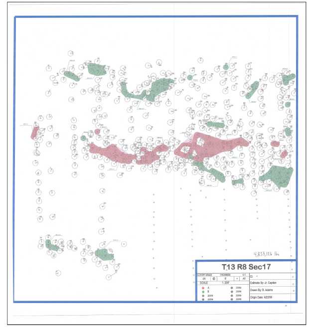
Resources for Section 17 were again calculated by the Company in 2007-2008. This work approached the project as a conventional mine development, and is very similar to the results of Geo-Management Inc. in 1989. The resource estimate utilized a variable cut-off, with results presented in Table 6-6. This resource was calculated through the circle-tangent method and utilization of a planimeter. No review of historical drill logs were used, and drill hole intercepts presented on historical maps were presumed accurate. This was the last resource estimate completed on the property prior to completion of this technical report. Figure 6-3 shows the circle tangent resource outlines that were reassessed by URI in 2008 for Section 17.
| Energy Fuels Resources. (USA) Inc. | |
| NI 43-101 Technical Review and Evaluation of the Exploration Potential of the Roca Honda Project | Page 26 |
Table 6-6. Resource Estimate, Uranium Resources, Inc. 2007, Section 17, T13N R8W
| Section | Cut-Off Grade | Tons | Average Grade
(%U3O8) |
Probable
Reserves (lbs U3O8) |
17 |
0.40 GT | 717,587 | 0.337 | 4,833,126 |
| 0.80 GT | 512,073 | 0.374 | 3,835,434 | |
| 1.20 GT | 483,940 | 0.393 | 3,799,162 |
| Energy Fuels Resources. (USA) Inc. | |
| NI 43-101 Technical Review and Evaluation of the Exploration Potential of the Roca Honda Project | Page 27 |
Figure 6-3. URI rework of historical circle-tangent resource for Section 17 113N R8W in 2008.
| Energy Fuels Resources. (USA) Inc. | |
| NI 43-101 Technical Review and Evaluation of the Exploration Potential of the Roca Honda Project | Page 28 |
| 6.4 |
Historic Production |
There has been no historic production within the Company’s Roca Honda project. Historical development activities have been limited to exploration and development drilling activities, and partial completion of the 14ft diameter shaft in the NE ¼ of Section 17.
| Energy Fuels Resources. (USA) Inc. | |
| NI 43-101 Technical Review and Evaluation of the Exploration Potential of the Roca Honda Project | Page 29 |
| 7 |
Geological Setting and Mineralization |
| 7.1 |
Geology and Stratigraphy |
| 7.1.1 |
Regional Geology |
The Roca Honda project is located in southeast part of the Ambrosia Lake Subdistrict (this area is sometimes referred to as the San Mateo Valley Subdistrict) of the Grants Uranium District (McLemore and Chenoweth, 1989), and located near the boundary of the Chaco Slope and Acoma Sag regional tectonic features. The Ambrosia Lake Subdistrict resides in the southeastern Colorado Plateau physiographic province and within the southern flank of the San Juan Basin. Regional geology is shown in Figure 7-1.
The San Juan Basin is truncated to the south and east of the project area by the Neogene volcanic rocks of the Mt. Taylor volcanic field, capping both Mesa Chivato and Horace Mesa. Bounding the basin to the southwest is the Zuni uplift, exposing rocks as old as Precambrian. On the Chaco slope, the predominantly Mesozoic strata dip to the north into the central San Juan Basin. The bounding structures of the San Juan Basin were formed largely during the Laramide Orogeny, extending from the Late Cretaceous through Eocene time.
The Morrison Formation, containing the Recapture Member, Westwater Canyon Member, and Brushy Basin Member in ascending order, outcrops near the southern edge of the San Juan Basin and dips northward into the basin. Between the Jurassic sediments and the overlying Late Cretaceous units is an erosional unconformity. The units overlying the unconformity in ascending order are Dakota Sandstone, Mancos Shale, Gallup Sandstone, Crevasse Canyon Sandstone, Point Lookout Sandstone, and Menefee Formation. The Gallup Sandstone, Crevasse Canyon Sandstone, Point Lookout Sandstone, and Menefee Formation compose the Mesaverde Group.
The primary host of uranium ore within the region is the Westwater Canyon Member of the late Jurassic Morrison Formation, with some localized mineralization occurring within the Poison Canyon Sandstone of the Brushy Basin Member. Regionally this deposit has been interpreted as forming on the distal portion of an alluvial fan. Braided streams originating in the mountains to the west and southwest carrying clasts of Precambrian granites, Paleozoic chert, metamorphic rocks, and other material deposited the ore-bearing channel sands. Interbedded shales were deposited in flood plains (lower energy environments), and fossil evidence also indicates some of the shales formed in local lacustrine environments (Turner-Peterson, 1986). Initially it was thought these deposits originated from a single source, the Mogollon Highlands, but provenance and paleocurrent studies suggest a much more varied source spanning from the west in Arizona to the south in New Mexico (Turner-Peterson 1986; Turner-Peterson and Fishman 1986; Lucas 2004). Timing of the Zuni Uplift to the southwest of the project is questionable, with some possibility of it providing some influence over depositional patterns in the Late Jurassic; however, it was not a major source of deposited sediments.
Formations of Late Cretaceous age are associated with either the shallow marine sea bottom or transgressive and regressive margins of the Western Interior Seaway.
| Energy Fuels Resources. (USA) Inc. | |
| NI 43-101 Technical Review and Evaluation of the Exploration Potential of the Roca Honda Project | Page 30 |
Figure 7-1. Regional geology map for the Grants Uranium District
| Energy Fuels Resources. (USA) Inc. | |
| NI 43-101 Technical Review and Evaluation of the Exploration Potential of the Roca Honda Project | Page 31 |
| 7.1.2 |
Local and Property Geology |
Stratigraphy
Descriptions of the strata that follow are specific to the stratigraphy of the Roca Honda project as interpreted from geologic mapping (Santos 1966; Santos 1970; McCraw et al. 2009), historical drill hole data, and local outcrops. The geologic map (Figure 7-2), stratigraphic column (Figure 7-3), and the following lithologic descriptions are modified from Santos (1966a & b), Santos (1970), McCraw et al. (2009) and Steven (2010).
Quaternary Deposits
Qal: Alluvial Deposits (Holocene and Pleistocene?)
Pale yellowish-brown and grayish-orange weathered alluvium deposited in graded stream valleys and recently incised arroyos.
Qc: Saprolite (Holocene and Pleistocene)
Weathered, in-situ bedrock, found in valleys and other low-lying areas.
Qt: Talus and Landslide blocks (Holocene and Pleistocene?)
Blocks of soil and/or bedrock that have moved down-slope by mass-wasting processes.
Mesaverde Group:
Menefee Formation
Kmf: Menefee Formation (Upper Cretaceous)
Pale yellowish-brown siltstone interbedded with pale yellowish-brown and light gray fine- to medium–grained sandstone.
Point Lookout Sandstone
Kp: Point Lookout Sandstone (Upper Cretaceous)
Light gray and reddish-brown medium- to fine-grained sandstone. Divisible into two parts where Satan Tongue of Mancos Shale is present.
Crevasse Canyon Formation
Kcg: Gibson Sandstone Member of the Crevasse Canyon Formation (Upper Cretaceous)
Interbedded sandstone, siltstone, shale, and coal beds.
Kcda: Dalton Sandstone Member of the Crevasse Canyon Formation (Upper Cretaceous)
Light gray medium- and fine-grained sandstone.
Kmm: Mulatto Tongue of Mancos Shale (Upper Cretaceous)
Pale yellowish-brown sandy shale, dark gray shale, and massive pale yellowish-brown fine-grained silty sandstone. Occurs between units Kcda and Kcdi of the Crevasse Canyon Formation.
| Energy Fuels Resources. (USA) Inc. | |
| NI 43-101 Technical Review and Evaluation of the Exploration Potential of the Roca Honda Project | Page 32 |
Kcdi: Dilco Coal Member of the Crevasse Canyon Formation (Upper Cretaceous)
Interbedded sandstone, siltstone, shale, and coal beds.
Gallup Sandstone
Kg: Main Body of the Gallup Sandstone (Upper Cretaceous)
Pale reddish-brown and light gray fine- and medium-grained sandstone.
Kmp: Pescado Tongue of the Mancos Shale (Upper Cretaceous)
Dark gray friable silty shale with minor thin light brown sandstone and gray fissile shale.
Kgb: Basal Member of the Gallup Sandstone (Upper Cretaceous)
Gray fossiliferous fine- and very coarse-grained sandstone.
Mancos Shale
Km: Main Body of the Mancos Shale (Upper Cretaceous)
Dark gray friable silty shale with minor thin light brown sandstone and gray fissile shale. Occurs below Kg and below Kgb of the Gallup Sandstone.
Kdt: Two Wells Sandstone Tongue of the Dakota Formation (Upper Cretaceous)
Yellowish-brown to tan very fine to medium-grained well-sorted calcareous sandstone. Locally interfingers with overlying Mancos Shale.
Kmw: Whitewater Arroyo Shale Tongue of the Mancos Shale (Upper Cretaceous)
Yellowish-brown to yellowish-grey fissile shale; locally contains beds of light-brown sandy siltstone and limestone.
Dakota Sandstone
Kd: Main Body of the Dakota Sandstone (Upper Cretaceous)
The Cretaceous Dakota Sandstone is a marginal marine deposit, and is composed of fine-grained grey sandstone. It sits unconformably on the Brushy Basin Member of the Morrison Formation.
Morrison Formation
Jmb: Brushy Basin Member of the Morrison Formation (Upper Jurassic)
The Brushy Basin Member of the Jurassic Morrison Formation is a fluvial/lacustrine deposit composed of pale greenish-gray claystone to fine-grained sandy claystone. Locally intertongues with the underlying Westwater Canyon Member.
Jmw: Westwater Canyon Member of the Morrison Formation (Upper Jurassic)
| Energy Fuels Resources. (USA) Inc. | |
| NI 43-101 Technical Review and Evaluation of the Exploration Potential of the Roca Honda Project | Page 33 |
The Westwater Canyon Member of the late Jurassic Morrison Formation is the primary host of uranium mineralization within the Ambrosia Lake District. It is comprised of a sequence of non-marine, fluvial, poorly sorted, fine to medium grained, cross-bedded arkosic sandstones and interstratified shales. The sandstones are light yellow and reddish-grey in color, and are composed of quartz grains (~61%), feldspars (~35%), chert (~3%), and heavy minerals (<0.5%) (Falkowski, 1980; Santos, 1970). The Westwater Canyon Member is overlain and intertongues with the Brushy Basin Member, and is underlain by the Recapture Member (90-290 feet). Within the Roca Honda project area the Westwater Canyon Member is subdivided into as many as seven sandstone units. These units are named alpha-numerically from upper to lower following the nomenclature trends of the historical operators.
Jmr: Recapture Member of the Morrison Formation (Upper Jurassic)
The Jurassic Recapture Member of the Morrison Formation consists of interbedded mudstone, claystone, siltstone, and a smaller amount of sandstone.
| Energy Fuels Resources. (USA) Inc. | |
| NI 43-101 Technical Review and Evaluation of the Exploration Potential of the Roca Honda Project | Page 34 |
Figure 7-2. Geology of the Roca Honda Project area.
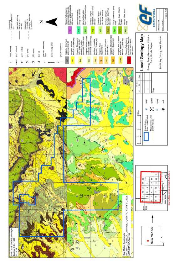
| Energy Fuels Resources. (USA) Inc. | |
| NI 43-101 Technical Review and Evaluation of the Exploration Potential of the Roca Honda Project | Page 35 |
Figure 7-3. General stratigraphic column for the Grants Uranium District.
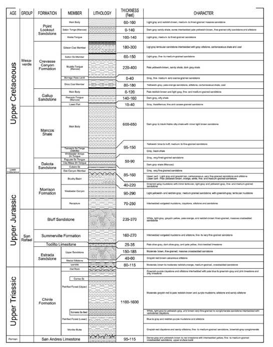
| Energy Fuels Resources. (USA) Inc. | |
| NI 43-101 Technical Review and Evaluation of the Exploration Potential of the Roca Honda Project | Page 36 |
| 7.2 |
Structure |
| 7.2.1 |
Regional Structure |
Regional structures in the Grants Uranium District, specifically the Ambrosia Lake Subdistrict west of the Property, formed during the Mesozoic and continued developing into the Tertiary. This period of deformation is coincident with the formation of the San Juan Basin. The majority of these structures are related to the uplift of the Zuni Mountains which has been periodically active since Pennsylvanian time (Santos, 1970). Structures associated with this period of Mesozoic-Tertiary deformation include normal faults, transform faults, as well as pre- and post-Dakota Sandstone folds. The regional trend of the major structures throughout the Grants Uranium District is to the north-northeast, but a wide range of other orientations also occur.
There are four major fault systems in the Ambrosia Lake Sub-district. The two nearest the Roca Honda project, the San Mateo and San Rafael fault zones, are located to the west and south of the project respectively. The San Mateo fault zone is composed of normal faults with throw down to the east, and has a maximum vertical offset of 450 feet (Santos, 1970); additionally, thinning of the Brushy Basin Member on opposite sides of this zone suggest that there is some lateral movement associated with this fault zone as well. This would suggest this overall fault zone is a right-lateral oblique fault zone with large components of both horizontal and vertical motion (Santos, 1970) The San Rafael fault zone, the largest in the region, differs in that most if not all movement is horizontal, with up to 20,000 feet of right-lateral displacement (Santos, 1970).
Pre-Dakota folding is not present in the Ambrosia Lake Sub-district, but is common in the Laguna Sub-district, approximately 30 miles to the southeast. There pre-Dakota folds have a maximum amplitude greater than 100 feet (Santos, 1970). Within the Ambrosia Lake Sub-district the major period of folding occurred following deposition of the Late Cretaceous Dakota Sandstone. The two largest folds in the region, the McCartys Syncline and the Ambrosia Dome both formed during this period of deformation, and have structural relief greater than 1000 feet (Santos, 1970). A third smaller fold, the San Mateo Dome, is located just north of the Roca Honda project. It dips east-southeast into the McCartys Syncline and gives local bedding a 7 to 11 degree dip (Faulk, 1978).
| 7.2.2 |
Project Area Structure |
A current and detailed study of the project area structural geology has not been completed by EFR. Completion of this study will require the development of a comprehensive drill hole database, cross sections, and 3-dimensional structural surface modeling. Previous detailed structural geology work by Kerr-McGee on Section 17 (Figure 7.4) indicate complex normal fault geometry, with the potential for some apparent structures to have formed as stress relief and in strike slip duplexes along bends in transform faults when reviewed at a larger scale (see Figure 7.2). No detailed structural geology work has been completed by the historical operators in any other area of the Company’s Roca Honda project.
| Energy Fuels Resources. (USA) Inc. | |
| NI 43-101 Technical Review and Evaluation of the Exploration Potential of the Roca Honda Project | Page 37 |
Figure 7-4. Structural geology of Section 17 T13N R8W as mapped on the surface of the Dakota Sandstone (Kd).
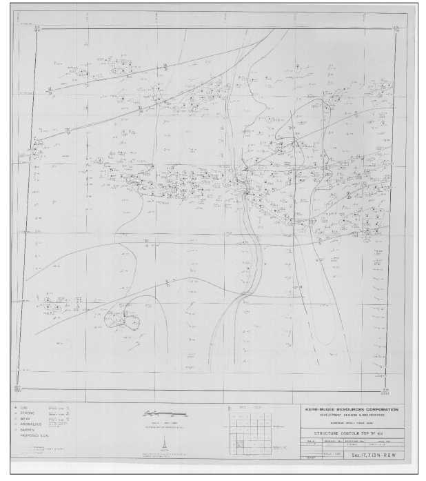
| Energy Fuels Resources. (USA) Inc. | |
| NI 43-101 Technical Review and Evaluation of the Exploration Potential of the Roca Honda Project | Page 38 |
| 7.3 |
Mineralization |
| 7.3.1 |
Roca Honda Project Mineralization |
The uranium mineralization found in the Roca Honda project is contained within the Westwater Canyon Member of the Morrison Formation. These zones may vary from one foot to over 30ft in thickness, 100ft to 400ft in width, and 200ft to over 3,000ft in length in elongate pods. Mineralization trends run from west to east, and northwest to southeast depending on general area within the project area. These trends of mineralization across the project area appear to be consistent with the fluvial sedimentary structures of the Westwater Canyon Member.
Uranium mineralization in the project area is believed to be predominantly primary (“trend”) mineralization, with some secondary mineralization due to oxidation and mobilization of uranium in the vicinity of permeable geologic structures. Although URI does not have core material from the project area, there are several data sets in the public from other drilling programs less than a mile from the Company’s Roca Honda project. Drilling and core recovery at Section 16 of Roca Honda Resources’ Roca Honda project (T13N, R8W, Sections 9, 10, and 16) indicate that the uranium mineralization occurs in fine to coarse sandstones with high (up to 2%) organic carbon in the form of humate material (Fitch, 2010; and RPA, 2012). Almost all trend ore within the Grants Uranium District is intimately associated with this humate material (Granger, 1968) derived from the decay of plant and animal matter. In addition to the humate material, the uranium deposits also contain variably enriched concentrations of vanadium, molybdenum, copper, selenium, and arsenic.
The primary mineralization pre-dates the formation of the Laramide aged structures in the project area, with a small amount of vertical offset of mineralization present across the local faults. In addition, and as noted above, there appears to be some amount of redistributed ore in the vicinity of these structures (“stacked ore”), however the dominant mineralization type at the Roca Honda Project appears to be primary in nature.
The approximate geographic location of uranium mineralization trends in the area of the Roca Honda project is shown in Figure 7.5. These trends have been adapted from McLemore and Chenoweth (1989), McLemore and Chenoweth (1991), RPA (2015); and historical resource maps based on work described in Section 6.3 of this report.
| Energy Fuels Resources. (USA) Inc. | |
| NI 43-101 Technical Review and Evaluation of the Exploration Potential of the Roca Honda Project | Page 39 |
Figure 7-5. Generalized uranium mineralization trends in the Roca Honda project area.
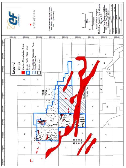
| Energy Fuels Resources. (USA) Inc. | |
| NI 43-101 Technical Review and Evaluation of the Exploration Potential of the Roca Honda Project | Page 40 |
| 7.3.2 |
Controls on Mineralization |
The uranium deposits of the Ambrosia Lake and San Mateo areas are generally related to and associated with fluvial paleoenvironments preserved in the Jurassic Morrison Formation (Riese and Brookins, 1977). Mineralization is generally confined to the fluvial sandstones of the Westwater Canyon Member and the Poison Canyon Sandstone of the Brushy Basin Member, though there may be some localized seepage into the under/overlying shales and mudstones, as well as some minor extension of mineralization into the underlying Recapture Member. Within the project area the Westwater Canyon Member contains as many as seven individual sandstones which the uranium mineralization is spread across. In the far western area of the project (Section 17) the uranium mineralization in generally in the upper two to three sandstones, with very few mineralized occurrences in the lower half of the Westwater Canyon Member. In the north-central portion of the project area (Section 11) the mineralization is concentrated in the lower sandstone units due to a pinching out of the upper sands and a thickening of the Brushy Basin Member. To the east of the project area the mineralization is spread across all of the sandstone units (including the Poison Canyon Sandstone), this area also appears to be in an area of overall convergence of mineralization at multiple horizons within the Westwater Canyon Member and observed within the Mt. Taylor Mine (Riese, 1973).
On a smaller scale, there is minor control of uranium mineralization by sedimentary structures. Historical mining operations at the Johnny M Mine, located just west of the project area, documented sandstone scours that truncated mineralization, indicating near syngenetic deposition of the mineralization and the host sandstone beds. Uranium may also be related to the presence of clay-gall layers, or carbon based detrital materials.
Geochemical environments in the host sandstone also play an important role in controlling the location of the uranium mineralization. Historical mining operations at both the Johnny M Mine and the Mt. Taylor Mine indicate that the uranium mineralization is generally located within a “halo” of reduced (“bleached”) ground. This reduced ground is reflected by light grey sandstone hues and blue-green reduced rims on clay-galls containing ferric iron.
As noted in the previous section, the local geologic structures post-date the formation of mineralization, a relationship confirmed by historical local mining operations which have penetrated these structures in other historical mines of the San Mateo Valley (RPA 2012). Therefore, it can be expected that the mineralization in the Roca Honda project will have vertical and/or horizontal offset in the presence of mineralization cut by faults.
| Energy Fuels Resources. (USA) Inc. | |
| NI 43-101 Technical Review and Evaluation of the Exploration Potential of the Roca Honda Project | Page 41 |
| 7.3.3 |
Mineralogy |
The Company has not completed any core drilling operations in the project area, and therefore lacks significant information on the uranium mineralogy and associated mineral assemblages. Based on adjacent operations (Johnny M Mine, San Mateo Mine, Roca Honda Resources LLC Roca Honda project, Mt. Taylor Mine), it could be suggested that the dominant uranium minerals in the project area are unidentifiable uranorganic oxide complexes (Falkowski 1980; RPA 2012), also supported by a documented direct correlation between weight percent content of organic carbon and uranium content in trend ore mineralization (Squyres 1970; Kendall 1972). Within the greater Grants Uranium District both coffinite and uraninite have been identified as the dominant uranium minerals in many deposits, but likely play a secondary role to these organic associated mineral assemblages in the project area that are primary (as opposed to redistributed) in nature. Associated gangue minerals include pyrite, marcasite, calcite, jordisite, ilsemannite, ferroselite (Kittel et al. 1967)
| Energy Fuels Resources. (USA) Inc. | |
| NI 43-101 Technical Review and Evaluation of the Exploration Potential of the Roca Honda Project | Page 42 |
| 8 |
Deposit Type |
The Westwater Canyon Member in the Grants Uranium District contains three general types of uranium mineralization: primary, redistributed (also known as “stack”, “post fault”, “roll front”), and remnant. Deposition of primary ore was controlled by sedimentary structures and most likely the presence of humate material. Formation of redistributed ore was controlled by the reductive capacity of the formation, as well as sedimentary and structural features.
Primary mineralization occurs in flat, elongate tabular ore bodies that are strata bound within permeable sandstones. These ore bodies may be several feet to thousands of feet in length. Multiple ore bodies may overlie one another in a single geologic unit when divided by discontinuous low permeability shales or mudstones. These depositional trends generally parallel each other. Primary mineralization in the Grants Uranium District consists mostly of uranium associated with organic materials as a coating on sand grains and impregnates the sandstone. Primary uranium deposits generally impart a dark gray to black color on the rock. Although past research has shown coffinite and uraninite to be the most common identifiable uranium minerals, the dominant uranium mineral is an unidentifiable uranorganic complex.
The deposits of the Roca Honda project are believed to be dominated by primary uranium mineralization, occurring as pods within chemically reduced fluvial sandstones. There is some potential of redistributed uranium mineralization along the boundaries of the reduced zones, as well as along sub-vertical fault structures that post-date the genesis of the primary uranium mineralization. The Melrich deposit in Section 32, T14N, R8W is believed to be redistributed mineralization.
| Energy Fuels Resources. (USA) Inc. | |
| NI 43-101 Technical Review and Evaluation of the Exploration Potential of the Roca Honda Project | Page 43 |
| 9 |
Exploration |
Historical exploration drilling for the project area was extensive as discussed in Section 6.2.
The Company has not completed any exploration field activities to further explore and develop the Roca Honda project.
| 9.1 |
Relevant Exploration Work |
The Company has not completed any exploration work in the Roca Honda project.
All exploration work in the Roca Honda project was completed by historical operators over a 20 year period spanning form the early 1960s to the early 1980s. A summary of the exploration campaigns by historical operators was presented in Section 6, with exploration methodologies summarized in Sections 10 and 11 of this document.
| 9.2 |
Exploration Potential |
Although significant historical resources have been identified by previous operators of the Roca Honda project, EFR has identified several exploration targets (Figure 9-1).
| Energy Fuels Resources. (USA) Inc. | |
| NI 43-101 Technical Review and Evaluation of the Exploration Potential of the Roca Honda Project | Page 44 |
Figure 9-1. Exploration potential of the Roca Honda project.
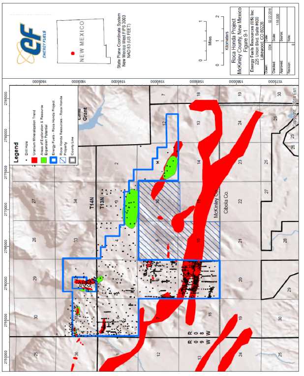
| Energy Fuels Resources. (USA) Inc. | |
| NI 43-101 Technical Review and Evaluation of the Exploration Potential of the Roca Honda Project | Page 45 |
| 9.2.1 |
Southwest Section 11 |
Historical data indicates the potential presence of significant uranium mineralization in Section 11 T13N R8W. Roca Honda Resources’ Roca Honda Project is directly to the west, and carries a NI 43-101 compliant resource of over 7.5 M lbs U3O8 in the C and D sands of the Westwater CanyonMember just within Section 10. Historical drilling on Section 10 has confirmed mineralization right to the section line between Section 10 and EFR’s contiguous Section 11.
Wide-spaced drilling in Section 11 by Conoco intersected a southeasterly extension of the adjoining Roca Honda deposit during the 1970s. The uranium mineralization in Section 11 is at depths ranging from 2,580 to 2,985 feet (786 to 910 meters). Mineralized intercepts for notable drill holes are shown in Table 9-1. GT contours of the uranium mineralization in Section 11 was developed by Neutron Energy. EFR has used a polygon method to depict the mineralized trend in section 11. This work is presented in Figure 9-2 and provides an excellent starting point for high potential resource development drilling in this area.
Table 9-1. Notable mineralization intercepts drilled by Conoco in Section 11, T13N R8W.
| Section | Conoco Drill
Hole No. |
Depth (ft bgs) |
Thickness (ft) | Grade (% U3O8) |
| 11 | C-3 | 2572.0 | 8.0 | 0.06 |
| 2591.0 | 15.5 | 0.15 | ||
| C-9 | 2631.0 | 10.0 | 0.30 | |
| C-11 | 2902.5 | 6.0 | 0.18 | |
| C-12 | 2942.5 | 24.5 | 0.17 | |
| C-13 | 2956.0 | 29.0 | 0.12 |
Conoco’s results are extremely encouraging in support of the EFR’s exploration and development concepts. It appears from the available data that the zone of uranium mineralization on Section 11 has not been fully constrained by drilling. The Section 11 target has only been tested by twelve holes in the south half of the section, and only two of the holes are within 400 feet of each other. These target zones require additional drilling to determine the full extent of the mineralization, as well as the continuity of mineralization between drill holes, and the effects (if any) of disequilibrium on the radiometric grades calculated from the gamma-ray logs.
Before the end of the previous uranium exploration cycle, the deposit on Section 11 was earmarked as Conoco’s next “minable reserves” delineation project. Their preliminary resource estimate was for 7-10 M lbs U3O8 in the deposit, which although it appears to be possibly optimistic, does indicate the potential of the area as determined by a historical owner of the project who was also a uranium producer.
In 1983 Homestake drilled one deep exploration hole in Section 11 after the claims were returned by Conoco. This drill hole, 11-R-9, was advanced to the southeast of the Conoco drill fence and along trend and intersected 14.0ft of mineralization averaging 0.292% U3O8 at a depth of 2,760ft.
In addition, a target for Section 12, T13N R8W may emerge from the results of further drilling on Section 11.
| Energy Fuels Resources. (USA) Inc. | |
| NI 43-101 Technical Review and Evaluation of the Exploration Potential of the Roca Honda Project | Page 46 |
Figure 9-2. Mineralization Potential.
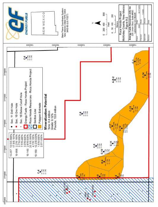
| 9.2.2 |
South Section 3 |
Although sparsely drilled, Section 3 exhibits some potential for the expansion of the resource coming off the north of Section 10. Topography in the northern limits of Section 10, and the southern limits of Section 3, have likely limited historical drilling operations in this area; however, there appears to be an open mineralization trend that extends into this region (RPA 2012) that warrants further exploration.
| Energy Fuels Resources. (USA) Inc. | |
| NI 43-101 Technical Review and Evaluation of the Exploration Potential of the Roca Honda Project | Page 47 |
Other Exploration Potential
Section 31, T14N, R8W
The historic drilling in Section 31 discovered several zones of significant uranium mineralization in two lenses of the upper sandstones of the Westwater. Some of the intercepts range from 8.0 feet to greater than 25 feet thick at grades from 0.25% up to 0.33% eU3O8. The area, previously known as the Frosty-Ox deposit, straddles the northern edge of the Endy claims. Enerdyne had a third party prepare a resource estimate in 1989 which resulted in approximately 300,000 tons of material at an average grade of 0.165% eU3O8. The orientation of the deposit is not the normal northwest to southeast as seen in most of the “trend” ore in the Ambrosia Lake-San Mateo sub-districts; therefore, it has not been determined if it is a trend or a redistributed deposit. Additional drilling will be needed on the EFR property, both to fill-in within the trend as well as determine the southwest and southern margins of the deposit. The deposit lies at the south toe of San Mateo Mesa and is about 1,650 feet deep. The steep cliffs that preclude vertical drilling from the surface on the south side of San Mateo Mesa explain why the deposit’s north edge is not better defined.
Section 32, T14N, R8W and Section 5, T13N, R8W
The Melrich deposit located on the patented claims in south-central Section 32 may continue onto the Endy claims in northern part of Section 5. Homestake estimated the Melrich deposit to be an historical resource of about 3.5 million pounds U3O8. It is hosted in the uppermost Westwatersandstone at a depth of about 1,900 feet. The deposit is oriented north-south, as are the normal faults in the area. It is redistributed-type of uranium mineralization related to the local zone of oxidation facilitated by the faults. Additional future drilling in Section 5 and on the Endy claims in Section 32 may discover extensions or similar north-south redistributed mineralization. Wider-spaced holes on the Endy claims to the west of the Melrich deposit have intercepted anomalous uranium mineralization indicating an additional exploration target for another potential northerly-trending deposit.
| Energy Fuels Resources. (USA) Inc. | |
| NI 43-101 Technical Review and Evaluation of the Exploration Potential of the Roca Honda Project | Page 48 |
| 10 |
Drilling |
This section presents information pertaining to the methods and procedures utilized by historical operators of the Roca Honda project. URI has not completed a drill program within the project area. All drilling discussed is historical in nature, and is described here to portray the nature and quality of the historical drill data held by the Company that may be utilized in future resource estimation exercises.
| 10.1 |
Type and Extent |
Although the Company has not completed any drilling operation in the Roca Honda project, the company does hold a significant amount of historical drilling records. The primary land position within the project area that holds historical mineral resources is Section 17 of T13N R8W, and along with the sparsely drilled Section 11, T13N R8W, constitutes the bulk of the project. On these two sections a total of 537 drill holes were completed by historical operators, or which the Company holds the geophysical logs for 525 drill holes (Table 10-1). For all project lands, the total logs held by EFR are 1,184.
Table 10-1 Historical Drilling Operations and Drill Data Owned by EFR
| Township and Range |
Section | Number of
Historical Drill Holes |
Number of Drill
Logs Owned by EFR |
| T13N R8W | 2 | Unknown | 9 |
| 3 | 35 | - | |
| 4 | 41 | - | |
| 5 | 74 | 74 | |
| 6 | 166 | 166 | |
| 8 | 215 | 215 | |
| 11 | 18 | 18 | |
| 12 | Unknown | 6 | |
| 17 | 518 | 518 | |
| T14N R8W | 31 | 184* | 178 |
| 32 | ~70* | - | |
| Total | 1,321 + Unknown | 1,184 |
All historical drilling in the project area was completed via mud rotary drilling methods. If any core drilling was completed in the project area, EFR does not have the historical records indicating such.
| 10.2 |
Procedures |
The typical drilling procedures followed by the historical mine development and operating companies in the Grants Uranium District was to utilize truck mounted drills to advance vertical exploration drill holes via conventionally circulated mud rotary drilling methods. The most common drill bit size would have been 4 ¾ inches in diameter. Drill cutting samples would be collected at the surface by the driller and laid out in piles near the drill rig in 5ft intervals, generally in rows of 20 samples equating to 100ft drilled depth. The cuttings were logged for lithology and alteration by a geologist and the information recorded on a drill log form. The exploratory drill holes were generally advanced through the entire section of the Westwater Canyon Member, and a few feet into the underlying Recapture Member.
| Energy Fuels Resources. (USA) Inc. | |
| NI 43-101 Technical Review and Evaluation of the Exploration Potential of the Roca Honda Project | Page 49 |
Upon completion of the exploration drill hole, the hole was logged with natural gamma, spontaneous-potential (SP), and resistivity downhole geophysical tools. The geophysical survey would be completed either by a contract logging company, or by a company owned logging truck. After completion of the various lithology based geophysical surveys, a drift tool was utilized to determine the deviation of the drill hole from vertical. Historically, these surveys were completed on 50ft or 100ft intervals over the entire length of the drill hole. Deviation of the exploration drill holes across the Roca Honda project in generally less than 5 degrees.
| Energy Fuels Resources. (USA) Inc. | |
| NI 43-101 Technical Review and Evaluation of the Exploration Potential of the Roca Honda Project | Page 50 |
| 11 |
Sample Preparation, Analysis and Security |
| 11.1 |
Historical Sampling Methods |
There are no records in the possession of the Company for physical samples of uranium mineralization collected from the Roca Honda project by the historical operators at that time, of the several individual projects. Data available to the company for the Roca Honda project area is limited to geophysical drill logs.
All data methods discussed are historical in nature, and is described here to portray the nature and quality of the historical drill data held by the Company that may be utilized in future resource estimation exercises.
| 11.1.1 |
Gamma Logging |
All mineralized intercepts utilized in the historical resource estimates were calculated from natural gamma geophysical logs. The log from this tool, along with the spontaneous-potential (SP) and resistivity logs formed the bulk of the data derived from the historical drilling programs. The gamma log was utilized to determine the location and grade of uranium mineralization, and the SP and resistivity logs for derivation of stratigraphy and lithology.
Interpretation of the gamma logs, and conversion of counts-per-second (cps) to equivalent U3O8 (eU3O8) was generally completed utilizing the industry standard methodologies developed by the U.S. Atomic Energy Commission (AEC) (Scott et. al. 1960; Stoll 1972; Christensen 1978). The AEC method relies on the AK=GT relationship, where A is the area under the curve, K is a constant of proportionality, G is the grade, and T is the thickness.
The area under the curve is determined by reading the counting rate values off of the gamma log via measurement of the response curve and multiplication of the values by the proper range value, resulting in the observed counting rate. The next step is to solve the formula N = n/(1-nt) for the corrected counting rate, where N is the corrected counting rate, n is the observed rate, and t is the proper dead time of the instrument. The first counting rate is read at the upper half amplitude point, and is the first value E1. The intermediate values from that point are designated I1, I2, etc., and are read on half-foot depth intervals. The last intermediate value to be read is just above the lower boundary of the mineralized zone, this being the lower half amplitude point. The total area under the curve can be divided into two tail areas and a central area. Each tail area extends to a point halfway between an E point and the adjacent I point. The value of the sum of the two tail area is approximated by added together the counting rates and E1 and E2 and then multiplying by a “tail factor”. A tail factor of 1.38 was used by the AEC and nearly all historical logging equipment when counting rate values are read at half foot intervals (Stoll 1972).
The value of the central area between the two tail areas is determined by summing the intermediate values represented by I1, I2, I3, etc. This resulting trapezoidal numerical integration has been found to be within 3% accuracy (Hallenburg 1973). The value of the total area under the anomalous portion of the curve is then determined be adding the value of the combined tail area to the value of the central area.
The value of the total area is then multiplied by correction factors such as those for drill hole diameter, drilling fluid, any casing materials, and the approximate water content of the mineralized material. The resulting corrected value is then multiplied by the calibration factor, “K”, to obtain the grade-thickness. The average grade of the zone is then determined by dividing the grade-thickness product by the zone thickness. A disequilibrium factor can then also be applied to the grade if sufficient data has been collected to support this adjustment.
| Energy Fuels Resources. (USA) Inc. | |
| NI 43-101 Technical Review and Evaluation of the Exploration Potential of the Roca Honda Project | Page 51 |
It should be noted that the rock volume sampled by the natural gamma logging tool is of significantly greater diameter than the of core material collected from the same drill hole. When the above calculation is properly applied, the gamma log data are frequently more representative of actual in place uranium mineralization grade and extent than chemical assay of core.
| 11.2 |
QA/QC Procedures |
The derivation of uranium grade across a mineralized intercept with a natural gamma tool is heavily based on the calibration of that tool against a gamma source of known uranium grade. This is accomplished utilizing calibration pits. The AEC developed and managed a series of pit in uranium producing areas of the country for this purpose (these pits are still in existence today and managed by the U.S. Department of Energy). Each site, at a minimum, has a low grade, middle grade, and high grade pit of known uranium grade to calibrate the gamma tool against and determine the “K” factor utilized in the mathematical determination of eU3O8. The use of the K-factor generated bycalibrating the gamma tool in the AEC calibration pits ties the grade interpretation for each mineralized intercept back to a known standard.
The down hole natural gamma geophysical probes used by the historical operators of the Roca Honda project, were generally calibrated at the AEC pits in Milan, New Mexico, and at times the master pits in Grand Junction, Colorado. K-factors generated by these calibration events are either recorded on the log headers, or in the case of the Ker-McGee owned logging truck, in master calibration books with the calibration event referenced on each log header. Logging companies utilized by the historical operators of the project include Century Geophysical and Neville Company, all of whom were experienced geophysical logging contractors active in the region at that time.
In addition to general logging tool calibration, a combination of log reruns and logging events duplicated by another logging tool or truck were used by the historical operator to ensure quality output from the logging activities.
| 11.3 |
Disequilibrium |
Disequilibrium is a term for any disparity in the normal ratio between uranium and its naturally occurring, gamma particle emitting daughter products which are measured by a natural gamma geophysical tool. This ratio is generally determined through comparison of chemical assay data (direct measurement of uranium content) against radiometric assay data (indirect measurement of uranium content). The ratio or disequilibrium between chemical and radiometric assay values of U3O8 is required due to the continuous decay of uranium.In a young deposit the uranium and its decay products may not have had time to reach equilibrium; this would result in a positive disequilibrium factor (DEF > 1.0). Conversely, due to the inherent solubility of uranium, it is possible for it to move from location to another, leaving the daughter products behind. In this case, the radiometric assays would be significantly higher than the chemical assays, yielded a negative DEF (< 1.0). Variations in the disequilibrium factor can greatly impact mineral resource estimates, and are therefore required to be determined to understand the true potential of a project.
| Energy Fuels Resources. (USA) Inc. | |
| NI 43-101 Technical Review and Evaluation of the Exploration Potential of the Roca Honda Project | Page 52 |
Historically in the Grants Uranium District, these checks occurred when drilled uranium mineral resources reached approximately 100,000 to 500,000 lbs of contained U3O8 (Fitch 1990). For many large producers with significant experience in exploration and production in a prolific district, it was not uncommon to drill out most of the resources in the project before obtaining the core material required to complete the necessary laboratory work for both determining any disequilibrium, as well as further mineralogical data necessary. Disequilibrium was seldom a factor for the high organic content primary ore in the Ambrosia Lake and San Mateo Valley areas of the Grants Uranium District. However, there was some varying amount of disequilibrium in redistributed and stack ore.
There is no report of core holes, or core material assays for the drilling performed by and of the historical operators of the Roca Honda project.
Roca Honda Resources, LLC has completed coring select Westwater sandstone intervals in four holes on their Roca Honda project, which is both adjacent and internal to EFR’s Roca Honda project. From their drill program in 2007, 6 samples were radiometric assayed in the laboratory for the comparison of against chemical (ICP MS) assay data. Although a very small sample population, analytical comparison indicated a DEF ranging from 1.00 to 2.16 (RPA 2015).
| 11.4 |
Opinion on Adequacy |
The type and quantity of data available for the Roca Honda project is typical of uranium project data collected in the late 1960s to early 1980s. Although historical geophysical data can be used for generation of NI 43-01 compliant resources, the company does not hold sufficient laboratory assay data to determine disequilibrium factors and confirm eU3O8assay grades with correlated laboratory cU3O8assay grades.A full and complete analysis of the historical data, as well as new additional data will be required to develop a resource estimate that meets the NI 43-101 mineral resource disclosure standards.
| Energy Fuels Resources. (USA) Inc. | |
| NI 43-101 Technical Review and Evaluation of the Exploration Potential of the Roca Honda Project | Page 53 |
| 12 |
Data Verification |
The Company has not completed any work to verify the historical data. This includes location and survey of historical drill collar locations, analysis and reinterpretation of historical gamma logs, and interpretation of stratigraphic units to confirm correlation of strata bearing uranium mineralization.
Data verification will need to be completed to confirm the quality of the historical data, and determine the full nature and extent of further work programs to advance the Roca Honda project.
| Energy Fuels Resources. (USA) Inc. | |
| NI 43-101 Technical Review and Evaluation of the Exploration Potential of the Roca Honda Project | Page 54 |
| 13 |
Mineral Process and Metallurgical Testing |
The Company has not conducted a mineralogical sampling and testing plan within the Roca Honda project.
As noted previously, Kerr-McGee did complete a mine plan for the Lee Mine (Falk 1978). In the mine plan, no metallurgical issues were presented or discussed. Kerr-McGee operated an acid leach mill in the district that processed over 7,000 tons per day (tpd), with recoveries of 94% to 97%. Any production from the Lee Mine (Section 17, T13N R8W) would have gone to this mill. Although it is believed that Kerr-McGee completed metallurgical testing on the Lee Mine ore, EFR does not possess any direct data or reports.
Subsequent to the conventional development project in the late 1970s and early 1980s, Rio Algom Mining Corporation (Rio Algom), who then controlled Kerr-McGee and the lease with Santa Fe, completed two core holes and a laboratory analysis to determine the in situ mining potential of the Lee Mine deposit on Section 17. Rio Algom completed two core holes on Section 17 (520C and 522C); drilling operations had significant difficulty, and only 20ft of core was recovered in each drill hole. The core was then sent to Hazen Research Inc. (Hazen) for pressurized bicarbonate leaching studies. Uranium content of the samples ranged from 0.300% to 2.38% cU3O8, with total organiccarbon content ranging from 0.28% to 5.9% and correlating well with uranium grade. Recoveries of uranium via pressurized bicarbonate leaching ranged from 33-39% (Hazen, 1991). Based on these results Rio Algom determined that the Lee Ranch Mine deposit on Section 17 had minimal potential for in situ recovery of the uranium resource, and recommended that the company complete no further testing to evaluate in situ mining (Rio Algom, 1991).
Metallurgical sampling and testing will be required as the project is progressed in order to prepare an adequate processing plan for the project.
In the event EFR moves the project to a producing mine stage, it will likely truck mined-material to its conventional uranium-vanadium mill (the White Mesa Mill) in Blanding, Utah. It is the only operating conventional uranium mill in the United States and has historically successfully processed uranium-bearing sandstone material for other Morrison Formation deposits throughout the Colorado Plateau.
| Energy Fuels Resources. (USA) Inc. | |
| NI 43-101 Technical Review and Evaluation of the Exploration Potential of the Roca Honda Project | Page 55 |
| 14 |
Mineral Resource Estimate |
Numerous owners and operators have completed exploration and development activities in the project area, and have completed resource estimates of a historical nature. All historical resources for the Roca Honda project are presented in Section 6 of this report. The resource estimates do not use the classification categories contained in the CIM Definition Standards on Mineral Resources and Reserves. Although the methodology was well documented, and industry standard practice by historical operators, the methodology for the resources discussed in Section 6 do not reflect current best industry practices. In addition, historical resources were in some cases deemed reserves without applicable mining standards and economics applied, and although those terms have been included here for completeness they should not be considered reserves by standard industry definition. EFI does not consider these historical resource estimates to be equivalent to current mineral resources or mineral reserves as defined in NI 43-101, nor has EFI completed sufficient work to confirm a NI 43-101 compliant resource. Therefore, the historical estimates cannot, and should not, be relied upon.
| Energy Fuels Resources. (USA) Inc. | |
| NI 43-101 Technical Review and Evaluation of the Exploration Potential of the Roca Honda Project | Page 56 |
| 15 |
Mineral Reserve Estimate |
There are no mineral reserves for the Roca Honda project at this time. Nor is there any guarantee that a future mineral resource estimate could be converted to mineral reserves with demonstrated economic viability.
| Energy Fuels Resources. (USA) Inc. | |
| NI 43-101 Technical Review and Evaluation of the Exploration Potential of the Roca Honda Project | Page 57 |
| 16 |
Mining Methods |
The Roca Honda project is believed to be best suited to conventional underground mining methods. This has been the method utilized by the adjacent historical mining operations including the adjacent Johnny M Mine and Mt. Taylor Mine. The adjoining Roca Honda project, operated by Roca Honda Resources, LLC, is also slated for conventional underground production.
| Energy Fuels Resources. (USA) Inc. | |
| NI 43-101 Technical Review and Evaluation of the Exploration Potential of the Roca Honda Project | Page 58 |
| 17 |
Recovery Methods |
This item not applicable until further work has been completed on the Roca Honda project.
| Energy Fuels Resources. (USA) Inc. | |
| NI 43-101 Technical Review and Evaluation of the Exploration Potential of the Roca Honda Project | Page 59 |
| 18 |
Project Infrastructure |
The Roca Honda project is located in a well-developed mining region. Due to the very new proximity of current mining projects there is significant infrastructure (roads, water, power) already in place and available to the Company.
During historical development of what was then termed the Lee Ranch Mine by Kerr McGee on Section 17, a shaft was started but not completed. The shaft is 14ft in diameter, and was completed to a depth of 1,478ft bgs, in the upper Westwater Canyon Member. The shaft is unfinished and does not penetrate the full thickness of the formation bearing the uranium mineralization. The original designed completion depth of the shaft was 1,630ft (Falk 1978). When Kerr McGee terminated their development of the Lee Mine in 1982, the shaft was capped to allow for future potential rehabilitation.
| Energy Fuels Resources. (USA) Inc. | |
| NI 43-101 Technical Review and Evaluation of the Exploration Potential of the Roca Honda Project | Page 60 |
| 19 |
Market Studies |
This item is not applicable to the Roca Honda project at this time.
| Energy Fuels Resources. (USA) Inc. | |
| NI 43-101 Technical Review and Evaluation of the Exploration Potential of the Roca Honda Project | Page 61 |
| 20 |
Environmental Studies, Permitting and Social or Community Impact |
Neutron Energy submitted a Plan of Operations to the USFS in 2009 for drilling as many as 260 exploration holes in Sections 11, 3, 5, 6 and 31. Biological and cultural resource studies were completed over those sections in support of the PoO and submitted to the USFS and NM Mining and Minerals Division. Although the USFS has suspended work on the PoO, it is still considered valid. EFR has not submitted any additional permit applications to regulatory agencies for exploration or mining activities. A full description of the required permits for exploration activities can be found in Section 4.4 of this report.
| Energy Fuels Resources. (USA) Inc. | |
| NI 43-101 Technical Review and Evaluation of the Exploration Potential of the Roca Honda Project | Page 62 |
| 21 |
Capital and Operating Costs |
This item is not applicable to the Roca Honda project at this time.
| Energy Fuels Resources. (USA) Inc. | |
| NI 43-101 Technical Review and Evaluation of the Exploration Potential of the Roca Honda Project | Page 63 |
| 22 |
Economic Analysis |
No economic analysis of the Roca Honda project has been completed.
| 22.1 |
Royalties |
Land positions on Sections 2, 3, 4, 5, 6, 8, 11, and 12 T13N R8W are controlled though unpatented mining claims, with a variety of surface owners. Portions of Sections 2, 4, and 11 T13N R8W are Cibola National Forest Surface and Federal minerals subject to the General Mining Law. Sections 5 and 6 are claimed in entirety with the surface managed by the BLM mineral estate subject to the General Mining Law. The entirety of Section 8 and a portion of Section 12 are within Fernandez surface and Federal mineral. Section 17 is fee simple mineral acquired from Santa Fe, with Fernandez holding the surface rights.
Claim blocks involved with this project area include the Endy (Sections 2, 3, 4, 5, 6, 11, 12, 31, 32) and the Roca Honda (Section 8). The Roca Honda claims are entirely owned by EFR, and the Endy claims are subject to terms with the mineral owner of record. The Endy claims are leased from Enerdyne Endy Claims LLC, and requires annual advance royalty payments of USD$75,000 and a 5% production royalty.
The property acquired from Santa Fe (Section 17) came with a surface agreement with Fernandez for access to these parcels. This surface agreement carries a 1% production royalty payable to Fernandez.
| Energy Fuels Resources. (USA) Inc. | |
| NI 43-101 Technical Review and Evaluation of the Exploration Potential of the Roca Honda Project | Page 64 |
| 23 |
Adjacent Properties |
Several historical mines, one mine on standby, and one planned mine are within a three mile radius of the Roca Honda Project (Figure 23-1):
Historical Mines
Cliffside Mine– Operated first by Phillips Petroleum, then by Kerr-McGee between 1960 and 1983, located in Section 36 T14N R8W, produced 9-11M lbs U3O8 from the same sandstone deposits as seen in the Roca Honda Project.
Johnny M Mine– Operated by Ranchers Exploration, located in Sections 7 and 18 T13N R8W and directly west of Roca Honda Project’s Section 17, produced approximately 5M lbs U3O8 from 1976 to 1982.
San Mateo Mine– Operated by Rare Metals Corp., El Paso Natural Gas Corp., and United Nuclear over the span of 14 years before mining ceased in 1971. Located in Sections 29 and 30 T13N R8W, and produced approximately 2M lbs U3O8. The San Mateo Mine exploited uranium ore predominantly contained in the Poison Canyon Sandstone, which is also present with mineralization in Section 13 near the Roca Honda Project.
Mine on Standby
Mt. Taylor Mine– Operated by Rio Grande Resources LLC (RGR), a subsidiary of General Atomics Co. Total resource at the Mt. Taylor Mine is in excess of 100M lbs U3O8 (Riese, 1977), with historical production of approximately 9M lbs U3O8 between 1979 and 1990.RGR is currently renewing their NMED Discharge Permit and moving their mine permit with NMMMD from “Standby” to “Active” status.
Proposed Mine
Roca Honda Mine– Operated by Roca Honda Resources, LLC, a joint venture between Energy Fuels Inc., and Sumitomo Corp. The project has progressed to a NI 43-101 compliant Preliminary Economic Study utilizing a Measured, Indicated, and Inferred resource of 25,770,000 lbs (U3O8) RPA2015). ( Measured and indicated 1,511,000 tons at 0.482%U3O8, 14.56 million pounds, and inferred 1,198,000 tons at 0.468%U3O8, 11.21million pounds). Project is currently in an advanced permitting phase with approval and commencement of construction anticipated for 2018-19.
Broad Oak Associates has not verified the information on the adjacent properties. The information is not necessarily indicative of the mineralization at the Roca Honda property.
| Energy Fuels Resources. (USA) Inc. | |
| NI 43-101 Technical Review and Evaluation of the Exploration Potential of the Roca Honda Project | Page 65 |
Figure 23-1. Mines and development projects located in the vicinity of the Roca Honda project.
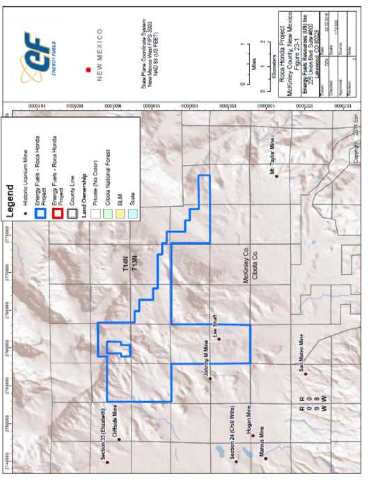
| Energy Fuels Resources. (USA) Inc. | |
| NI 43-101 Technical Review and Evaluation of the Exploration Potential of the Roca Honda Project | Page 66 |
| 24 |
Other Relevant Data and Information |
There is no other relevant data or information on the Roca Honda project to be presented at this time.
| Energy Fuels Resources. (USA) Inc. | |
| NI 43-101 Technical Review and Evaluation of the Exploration Potential of the Roca Honda Project | Page 67 |
| 25 |
Interpretation and Conclusions |
The Roca Honda project may host a potentially significant uranium resource located amongst known and defined projects including some of the largest and highest grade deposits in the United States.
Historical, noncompliant resource estimates from previous operators suggest that Section 17 T13N R8W contains a multi-million pound uranium deposit. In addition, there are numerous indications of open ended trends that present substantial upside potential to expand the potential mineral resources of the Roca Honda project. A full and modern analysis and interpretation is required to confirm the historical data, advance the geologic understanding, and progress the project. Additional subsurface data collection, including core samples for laboratory analysis, are required for development of a NI 43-101 compliant resource estimate for the Roca Honda project.
| 25.1 |
Significant Risks and Uncertainties |
As with most projects at this stage of exploration and resource definition, there are risks and uncertainties associated with further development of the project as outlined below.
| 25.1.1 |
Exploration |
Should EFI elect to advance the Roca Honda project and develop a NI 43-101 compliant resource, further exploration drilling will be required for the purposes of:
| • | Confirmation of mineralization; | |
| • | Core samples for mineralogical and process studies; and, | |
| • | Resource expansion. |
The current stage of the Roca Honda project implies a high level of risk. Historical data must be reviewed, and confirmed with further analysis. Further work may lead to discovery of issues with the historical data such as disequilibrium concerns, or lack of mineralization continuity as historically interpreted.
| 25.1.2 |
Mineral Resource Estimate |
A NI 43-101 compliant resource estimate for the Roca Honda project cannot be developed at this time. In order to prepare a modern mineral resource estimate for the Roca Honda project it is necessary for URI to undertake a comprehensive exploration drilling program to collect the required technical data. Although the historical resource estimates were completed by uranium producers in the Grants Uranium District with significant experience, there is risk that a new compliant resource may be considerably different that those portrayed in the historical resource estimates. As such, the historical mineral resource estimates cannot be relied upon in any manner.
| Energy Fuels Resources. (USA) Inc. | |
| NI 43-101 Technical Review and Evaluation of the Exploration Potential of the Roca Honda Project | Page 68 |
| 25.1.3 |
Foreseeable Impacts of Risk |
The risk of EFI initiating exploration activities at the Roca Honda project are commensurate with the current stage of the project. There is the potential for both significant upside, and downside. It is the author’s opinion though, that the Roca Honda project would likely present a greater upside to EFI once the historical data has been validated and the Company undertakes a certain level of work to develop a NI 43-101 compliant resource. Additionally, the potential to further expand the historical resource is questionable, as in most mineral exploration. However, the Roca Honda project appears to be of sufficient magnitude at this project stage that any expansion of the mineralization trends would only serve to increase the Company’s interest in the Roca Honda project as a serious development prospect.
| Energy Fuels Resources. (USA) Inc. | |
| NI 43-101 Technical Review and Evaluation of the Exploration Potential of the Roca Honda Project | Page 69 |
| 26 |
Recommendations |
Broad Oak Associates recommends that URI continue to review, analyze, and interpret the historical data, and develop new data, in order to develop NI 43-101 compliant resources for the Roca Honda project. The following recommendations are provided in a phased approach:
Phase I
| o |
Continue review and reinterpret lithology and uranium mineralization from all historical drill logs. This work should include digitization of the historical data and creation of a database to archive/manage the data. | |
|
| ||
| o |
Complete geologic and resource models of the Roca Honda project from the historical data. Models should focus on stratigraphic and structural interpretations, and continuity of mineralization. Resource estimates should be completed through use of modern 3D geostatistical analysis, rather than the historical geometric methods. | |
|
| ||
| o |
Complete new wholistic interpretations of the Roca Honda project and develop a drill plan with the following goals: |
| • | Confirm historical mineralization; | |
| • | Test potential areas for resource expansion; and, | |
| • | Sample collection for chemical assay, disequilibrium studies, and rock density testing in as many mineralized zones as possible. |
Phase II (only to be conducted if Phase I was successful)
| o | Update Surface Access Agreement with Fernandez and Co. | |
| o | Complete necessary environmental work necessary to permit the drill plan, most notably cultural resource surveys over Section 17. | |
| o | Permit the drill plan with the State of New Mexico and USFS as necessary. |
Phase III (only to be conducted if Phase II was successful)
| o | Complete the drilling, sample collection, and analysis scoped in Phase I | |
| o | Complete interpretation of the new data from the drilling program, integrate with the historical data and adjust project interpretations as necessary. | |
| o | Utilize historical and new project data to develop new mineral resource estimates that are NI 43-101 compliant. | |
| o | Complete NI 43-101 Technical Report with compliant resources for Sections 11 and 17 of the Roca Honda Project. |
Broad Oak Associates anticipates that the work program scoped above would require approximately 2 to 3 years to complete depending on actual permit review timeframes. The estimated budget for the program is US$4.1M (Table 26-1) with the majority of costs falling in Phase III, in addition there are two work program items for which costs cannot be estimated due to transactional relationships with third parties that cannot be quantified at this time.
| Energy Fuels Resources. (USA) Inc. | |
| NI 43-101 Technical Review and Evaluation of the Exploration Potential of the Roca Honda Project | Page 70 |
Table 26-1. Estimated cost for Three Phase Work Program for Roca Honda Project.
| Activity | Estimated Cost (USD) |
| Phase I | |
| Digitize historical drill data and geophysical logs | 10,000 |
| Development
of a historical drill hole database,
with reinterpretation of historical drill logs. |
20,000 |
| Geologic Model | 20,000 |
| Resource Model (historical data) | 30,000 |
| Develop Drill Plan | 20,000 |
| Phase I Subtotal | $100,000 |
| Phase II | |
| Renegotiate
Surface Use Agreement with Fernandez
and Co. to include full project area as needed for field operations. |
Unknown |
| Environmental and Cultural Survey Work to Clear Sections 11, 17. | 50,000 |
| Drill Program Permitting with NMMMD and USFS | 120,000 |
| Phase II Subtotal | $170,000 |
| Phase III | |
| Drill
Program Field Work (Assume 20 drill holes, of which
4 are core holes, as well as all associated supporting activities) |
1,500,000 |
| Analytical Program | 120,000 |
| Update Geologic and Resource Models | 30,000 |
| Consulting
services for completion of a NI
43-101 Technical Report with Compliant Resources for Sections 11 and 17, T13N R8W. |
40,000 |
| Phase III Subtotal | $1,690,000 |
| Total | $1,960,000 |
| Energy Fuels Resources. (USA) Inc. | |
| NI 43-101 Technical Review and Evaluation of the Exploration Potential of the Roca Honda Project | Page 71 |
| 27 |
References |
Christensen, G.D. 1978. Gamma Log Interpretation. Kerr-McGee Resources, Uranium Exploration Division, Northern Rocky Mountain Division. 21 p.
Continental Oil Company. 1976. Geology and Uranium Potential of Conoco’s Roca Honda Property, Grants Mineral Belt, New Mexico. Continental Oil Company, Mineral Department Report, June 1976. 40 p.
Dames and Moore. 1979. Ore Reserve Estimate, Basic Mine Design, and Capital and Operating Costs for the Roca Honda Property of Kerr-McGee Nuclear Corporation. Report prepared for Kerr-McGee, August 1979.
Falk, E.L. 1978. Roca Honda Mine Plan, Section 9 and 10, T13N, R8W, McKinley County, NM. Kerr-McGee Resources Corporation internal correspondence.
Falkowski, S.K. 1980. The Geology and Ore Deposits of the Johnny M Mine, Ambrosia Lake District, Grants, New Mexico. Master’s thesis. New Mexico Institute of Mining and Technology, Socorro, New Mexico. 152 p.
Fitch, D.C. 1990. Uranium Exploration and Geology, in Kennedy, B.A., ed., Surface Mining, 2nd Edition, Society for Mining, Metallurgy, and Exploration Inc., Littleton, CO, Chapter 2.4, p.35-48.
Fitch, D.C. 2010. Technical Report on the Roca Honda Uranium Property, McKinley County, New Mexico. Technical Report prepared for Strathmore Minerals Corp, June 30, 2010.
Granger, H.C. 1968. Localization and Control of Uranium Deposits in the Southern San Juan Basin Mineral Belt, New Mexico, in Geological Survey Research 1968, U.S. Geological Survey Professional Paper 600-B, p.B60-B70.
Hallenburg, J.K. 1973. Interpretation of Gamma-Ray Logs. Society of Petrophysicists & Well Log Analysts, Annual Well Logging Symposium, 1973. 29 p.
Hazen Research Inc. 1991. Bicarbonate Pressure Leaching of New Mexico Uranium-Bearing Core Samples. Prepared for Rio Algom Mining Corporation. Golden, Colorado.
Kendall, E.W. 1972. Trend Orebodies of the Section 27 Mine, Ambrosia Lake Uranium District, New Mexico. PhD dissertation, University of California, Berkeley. 167 p.
Kerr-McGee Nuclear Corporation. 1976. Project Proposal, Roca Honda Mine, East Ambrosia Lake Area, McKinley County, New Mexico. Internal project proposal, August 1976. 32 p., 6 figures.
Kittel, D.F. et. al. 1967. Uranium Deposits of the Grants Region, in New Mexico Geological Society Guidebook – Eighteenth Field Conference, p. 173-183.
Lucas, S.G. 2004. The Triassic and Jurassic Systems in New Mexico,” in The Geology of New Mexico, A Geologic History. New Mexico Geological Society, p. 137-152.
McCraw, D.J., et. al. 2009. Geologic Map of the Roca Honda Quadrangle, McKinley and Cibola Counties, New Mexico. New Mexico Bureau of Geology and Mineral Resources, Open File Geologic Map 194, scale 1:24,000, 1 plate, 1 report, and GIS data, CD-ROM.
| Energy Fuels Resources. (USA) Inc. | |
| NI 43-101 Technical Review and Evaluation of the Exploration Potential of the Roca Honda Project | Page 72 |
McLemore, V.T., and Chenoweth, W.L. 1991. Uranium Mines and Deposits in the Grants district, Cibola and McKinley Counties, New Mexico, New Mexico Bureau of Geology and Mineral Resources, Open-file Report 353.
McLemore, V.T., and Chenoweth, W.L. 1989. Uranium Resources in New Mexico, New Mexico Bureau of Geology and Mineral Resources, Map MR-18, 36p, 1 sheet, scale 1:1,000,000.
Riese, W.C. 1977. Geology and Geochemistry of the Mount Taylor Uranium deposit, Valencia County, New Mexico. MS Thesis, University of New Mexico, Albuquerque, New Mexico.
Riese, W.C., and D.G. Brookins. 1977. Subsurface Stratigraphy of the Morrison Formation in the Mount Taylor Area and its Relation to Uranium Ore Genesis, in New Mexico Geological Society Guidebook, 28th Field Conference, San Juan Basin III, 1977.
Rio Algom Mining. 1991. ISL Feasibility Report, Lee Mine Property, Section 17, T13N, R8W, McKinley County, New Mexico.
Roca Honda Resources. 2009a. Baseline Data Report. Report prepared for New Mexico Mining and Minerals Division and U.S. Forest Service, October 2009.
Roca Honda Resources. 2009b. Permit Application for a New Mine (Roca Honda). Report prepared for New Mexico Mining and Minerals Division and U.S. Forest Service, October 2009.
Roscoe Postle (USA) Ltd. 2015. Technical Report on the Roca Honda Project, McKinley County, State of New Mexico, USA.,. Report prepared for Roca Honda Resources, LLC.
Santos, E.S. 1970. Stratigraphy of the Morrison Formation and Structure of the Ambrosia Lake District, New Mexico. U.S. Geological Survey Bulletin 1272-E, 1970.
Santos, E.S. 1966a. Geologic Map of the Roca Honda Quadrangle, McKinley and Valencia Counties, New Mexico. U.S. Geological Survey Map GQ-517, scale 1:24,000.
Santos, E.S. 1966b. Geologic Map of the San Lucas Dam Quadrangle, McKinley County, New Mexico. U.S. Geological Survey Map GQ-516, scale 1:24,000.
Scott, J.H., et. al. 1960. Quantitative Interpretation of Gamma-Ray Logs. U.S. Atomic Energy Commission, RME-136. Grand Junction, Colorado.
Squyres, J.B. 1970. Origin and Depositional Environment of Uranium Deposits of the Grants Region, New Mexico. PhD dissertation, Stanford University, 228 p.
Steven, Cather. 2010. Preliminary Geologic Map of the San Luca Dam Quadrangle, McKinley County, New Mexico. New Mexico Bureau of Geology and Mineral Resources, Open File Geologic Map – 212.
Stoll. M.G. 1972. Field Methods of Determining Uranium Ore Reserves. U.S. Atomic Energy Commission, Grand Junction Office. Grand Junction, Colorado.
Turner-Peterson, C.E. 1986. Fluvial Sedimentology of a Major Uranium Bearing Sandstone – A Study of the Westwater Canyon Member of the Morrison Formation, San Juan Basin, New Mexico, in Turner-Peterson, C.E. et. al. ed., A Basin Analysis Case Study: The Morrison Formation, Grants Uranium Region, New Mexico. AAPG Studies in Geology #22. p. 47-76.
| Energy Fuels Resources. (USA) Inc. | |
| NI 43-101 Technical Review and Evaluation of the Exploration Potential of the Roca Honda Project | Page 73 |
Turner-Peterson, C.E., and N.S. Fishman. 1986. Geologic Synthesis and Genetic Models for Uranium Mineralization in the Morrison Formation, Grants Uranium Region, New Mexico, in Turner-Peterson, C.E. et. al. ed., A Basin Analysis Case Study: The Morrison Formation, Grants Uranium Region, New Mexico. AAPG Studies in Geology #22. p. 357-388.
Wentworth, D.W. 1982. Uranium Geology Potential of the Roca Honda Area, McKinley and Valencia Counties, New Mexico. Continental Oil Company Report. 34 p.
| Energy Fuels Resources. (USA) Inc. | |
| NI 43-101 Technical Review and Evaluation of the Exploration Potential of the Roca Honda Project | Page 74 |
| 28 |
Glossary |
| 28.1 |
Mineral Resources |
The mineral resources and mineral reserves have been classified according to the “CIM Standards on Mineral Resources and Reserves: Definitions and Guidelines” (November 27, 2010). Accordingly, the Resources have been classified as Measured, Indicated or Inferred, the Reserves have been classified as Proven, and Probable based on the Measured and Indicated Resources as defined below.
A Mineral Resource is a concentration or occurrence of natural, solid, inorganic or fossilized organic material in or on the Earth’s crust in such form and quantity and of such a grade or quality that it has reasonable prospects for economic extraction. The location, quantity, grade, geological characteristics and continuity of a Mineral Resource are known, estimated or interpreted from specific geological evidence and knowledge.
An ‘Inferred Mineral Resource’ is that part of a Mineral Resource for which quantity and grade or quality can be estimated on the basis of geological evidence and limited sampling and reasonably assumed, but not verified, geological and grade continuity. The estimate is based on limited information and sampling gathered through appropriate techniques from locations such as outcrops, trenches, pits, workings and drillholes.
An ‘Indicated Mineral Resource’ is that part of a Mineral Resource for which quantity, grade or quality, densities, shape and physical characteristics can be estimated with a level of confidence sufficient to allow the appropriate application of technical and economic parameters, to support mine planning and evaluation of the economic viability of the deposit. The estimate is based on detailed and reliable exploration and testing information gathered through appropriate techniques from locations such as outcrops, trenches, pits, workings and drillholes that are spaced closely enough for geological and grade continuity to be reasonably assumed.
A ‘Measured Mineral Resource’ is that part of a Mineral Resource for which quantity, grade or quality, densities, shape, physical characteristics are so well established that they can be estimated with confidence sufficient to allow the appropriate application of technical and economic parameters, to support production planning and evaluation of the economic viability of the deposit. The estimate is based on detailed and reliable exploration, sampling and testing information gathered through appropriate techniques from locations such as outcrops, trenches, pits, workings and drillholes that are spaced closely enough to confirm both geological and grade continuity.
| 28.2 |
Abbreviations |
The following abbreviations may be used in this report.
Table 26.4.1
| Abbreviation | Unit or Term |
| A | ampere |
| AA | atomic absorption |
| A/m2 | amperes per square meter |
| Energy Fuels Resources. (USA) Inc. | |
| NI 43-101 Technical Review and Evaluation of the Exploration Potential of the Roca Honda Project | Page 75 |
| Abbreviation | Unit or Term |
| ANFO | ammonium nitrate fuel oil |
| Ag | silver |
| Au | gold |
| AuEq | gold equivalent grade |
| °C | degrees Centigrade |
| CCD | counter-cURInt decantation |
| CIL | carbon-in-leach |
| CoG | cut-off grade |
| cm | centimeter |
| cm2 | square centimeter |
| cm3 | cubic centimeter |
| cfm | cubic feet per minute |
| ConfC | confidence code |
| CRec | core recovery |
| CSS | closed-side setting |
| CTW | calculated true width |
| ° | degree (degrees) |
| dia. | diameter |
| EIS | Environmental Impact Statement |
| EMP | Environmental Management Plan |
| FA | fire assay |
| ftft. | foot (feet) |
| ft2 | square foot (feet) |
| ft3 | cubic foot (feet) |
| g | gram |
| gal | gallon |
| g/L | gram per liter |
| g-mol | gram-mole |
| gpm | gallons per minute |
| g/t | grams per tonne |
| ha | hectares |
| HDPE | High Density Polyethylene |
| hp | horsepower |
| HTW | horizontal true width |
| ICP | induced couple plasma |
| ID2 | inverse-distance squared |
| ID3 | inverse-distance cubed |
| IFC | International Finance Corporation |
| Energy Fuels Resources. (USA) Inc. | |
| NI 43-101 Technical Review and Evaluation of the Exploration Potential of the Roca Honda Project | Page 76 |
| Abbreviation | Unit or Term |
| ILS | Intermediate Leach Solution |
| kA | kiloamperes |
| kg | kilograms |
| km | kilometer |
| km2 | square kilometer |
| koz | thousand troy ounce |
| kt | thousand tonnes |
| kt/d | thousand tonnes per day |
| kt/y | thousand tonnes per year |
| kV | kilovolt |
| kW | kilowatt |
| kWh | kilowatt-hour |
| kWh/t | kilowatt-hour per metric tonne |
| L | liter |
| L/sec | liters per second |
| L/sec/m | liters per second per meter |
| lb | pound |
| LHD | Long-Haul Dump truck |
| LLDDP | Linear Low Density Polyethylene Plastic |
| LOI | Loss On Ignition |
| LoM | Life-of-Mine |
| m | meter |
| m2 | square meter |
| m3 | cubic meter |
| masl | meters above sea level |
| MARN | Ministry of the Environment and Natural Resources |
| MDA | Mine Development Associates |
| mg/L | milligrams/liter |
| mm | millimeter |
| mm2 | square millimeter |
| mm3 | cubic millimeter |
| MME | Mine & Mill Engineering |
| Moz | million troy ounces |
| Mt | million tonnes |
| MTW | measured true width |
| MW | million watts |
| m.y. | million years |
| NGO | non-governmental organization |
| Energy Fuels Resources. (USA) Inc. | |
| NI 43-101 Technical Review and Evaluation of the Exploration Potential of the Roca Honda Project | Page 77 |
| Abbreviation | Unit or Term |
| NI 43-101 | Canadian National Instrument 43-101 |
| OSC | Ontario Securities Commission |
| oz | troy ounce |
| % | percent |
| PLC | Programmable Logic Controller |
| PLS | Pregnant Leach Solution |
| PMF | probable maximum flood |
| ppb | parts per billion |
| ppm | parts per million |
| QA/QC | Quality Assurance/Quality Control |
| RC | rotary circulation drilling |
| RoM | Run-of-Mine |
| RQD | Rock Quality Description |
| SEC | U.S. Securities & Exchange Commission |
| sec | second |
| SG | specific gravity |
| SPT | standard penetration testing |
| st | short ton (2,000 pounds) |
| t | tonne (metric ton) (2,204.6 pounds) |
| t/h | tonnes per hour |
| t/d | tonnes per day |
| t/y | tonnes per year |
| TSF | tailings storage facility |
| TSP | total suspended particulates |
| µm | micron or microns |
| V | volts |
| VFD | variable frequency drive |
| W | watt |
| XRD | x-ray diffraction |
| y | year |
| Energy Fuels Resources. (USA) Inc. | |
| NI 43-101 Technical Review and Evaluation of the Exploration Potential of the Roca Honda Project | Appendices |
Appendices
| Energy Fuels Resources. (USA) Inc. | |
| NI 43-101 Technical Review and Evaluation of the Exploration Potential of the Roca Honda Project | Appendix A |
Appendix A: Mineral Claims
| Claim Name/Number |
Serial No | Claimant | MER | TWN | RANGE | SEC | Subdv | LOC DATE |
| Endy #1 | NMMC171172 | Enerdyne Endy Claims | NMPM | 14N | 08W | 31 | NW | 20/10/2004 |
| Endy #2 | NMMC171173 | Enerdyne Endy Claims | NMPM | 14N | 08W | 31 | NW,SW | 20/10/2004 |
| Endy #3 | NMMC171174 | Enerdyne Endy Claims | NMPM | 14N | 08W | 31 | SW | 20/10/2004 |
| Endy #4 | NMMC171175 | Enerdyne Endy Claims | NMPM | 14N | 08W | 31 | SW | 20/10/2004 |
| Endy #5 | NMMC171176 | Enerdyne Endy Claims | NMPM | 14N | 08W | 31 | SW | 20/10/2004 |
| Endy #6 | NMMC171177 | Enerdyne Endy Claims | NMPM | 14N | 08W | 31 | SW | 20/10/2004 |
| Endy #8 | NMMC171178 | Enerdyne Endy Claims | NMPM | 14N | 08W | 31 | NE,NW,SW,SE | 20/10/2004 |
| Endy #9 | NMMC171179 | Enerdyne Endy Claims | NMPM | 14N | 08W | 31 | SW,SE | 20/10/2004 |
| Endy #10 | NMMC171180 | Enerdyne Endy Claims | NMPM | 14N | 08W | 31 | SW,SE | 20/10/2004 |
| Endy #11 | NMMC171181 | Enerdyne Endy Claims | NMPM | 14N | 08W | 31 | SW,SE | 20/10/2004 |
| Endy #12 | NMMC171182 | Enerdyne Endy Claims | NMPM | 14N | 08W | 31 | SW,SE | 20/10/2004 |
| Endy #14 | NMMC171183 | Enerdyne Endy Claims | NMPM | 14N | 08W | 31 | SW,SE | 20/10/2004 |
| Endy #15 | NMMC171184 | Enerdyne Endy Claims | NMPM | 14N | 08W | 31 | SE | 20/10/2004 |
| Endy #16 | NMMC171185 | Enerdyne Endy Claims | NMPM | 14N | 08W | 31 | SE | 20/10/2004 |
| Endy #17 | NMMC171186 | Enerdyne Endy Claims | NMPM | 14N | 08W | 31 | SE | 20/10/2004 |
| Endy #18 | NMMC171187 | Enerdyne Endy Claims | NMPM | 14N | 08W | 31 | SE | 20/10/2004 |
| Endy #20 | NMMC171189 | Enerdyne Endy Claims | NMPM | 14N | 08W | 31 | NE,SE | 20/10/2004 |
| Endy #21 | NMMC171190 | Enerdyne Endy Claims | NMPM | 14N | 08W | 31 | SE | 20/10/2004 |
| Endy #22 | NMMC171191 | Enerdyne Endy Claims | NMPM | 14N | 08W | 31 | SE | 20/10/2004 |
| Endy #23 | NMMC171192 | Enerdyne Endy Claims | NMPM | 14N | 08W | 31 | SE | 20/10/2004 |
| Endy #24 | NMMC171193 | Enerdyne Endy Claims | NMPM | 14N | 08W | 31 | SE | 20/10/2004 |
| Endy #25 | NMMC171194 | Enerdyne Endy Claims | NMPM | 14N | 08W | 32 | NW | 20/10/2004 |
| Endy #26 | NMMC171195 | Enerdyne Endy Claims | NMPM | 14N | 08W | 32 | NW,SW | 20/10/2004 |
| Endy #27 | NMMC171196 | Enerdyne Endy Claims | NMPM | 14N | 08W | 32 | SW | 20/10/2004 |
| Endy #28 | NMMC171197 | Enerdyne Endy Claims | NMPM | 14N | 08W | 32 | NW | 20/10/2004 |
| Endy #29 | NMMC171198 | Enerdyne Endy Claims | NMPM | 14N | 08W | 32 | NW | 20/10/2004 |
| Endy #30 | NMMC171199 | Enerdyne Endy Claims | NMPM | 14N | 08W | 32 | NE,NW | 20/10/2004 |
| ENDY #31 | NMMC171200 | Enerdyne Endy Claims | NMPM | 13N | 08W | 5 | NW | 20/10/2004 |
| ENDY #32 | NMMC171201 | Enerdyne Endy Claims | NMPM | 13N | 08W | 5 | NW | 20/10/2004 |
| ENDY #33 | NMMC171202 | Enerdyne Endy Claims | NMPM | 13N | 08W | 5 | NW | 20/10/2004 |
| ENDY #34 | NMMC171203 | Enerdyne Endy Claims | NMPM | 13N | 08W | 5 | NW | 20/10/2004 |
| ENDY #35 | NMMC171204 | Enerdyne Endy Claims | NMPM | 13N | 08W | 5 | NW SW | 20/10/2004 |
| Endy #36 | NMMC171205 | Enerdyne Endy Claims | NMPM | 14N | 08W | 32 | NE,NW | 20/10/2004 |
| Endy #37 | NMMC171206 | Enerdyne Endy Claims | NMPM | 14N | 08W | 32 | NE,SE | 20/10/2004 |
| Endy #38 | NMMC171207 | Enerdyne Endy Claims | NMPM | 14N | 08W | 32 | SE | 20/10/2004 |
| Endy #39 | NMMC171208 | Enerdyne Endy Claims | NMPM | 14N | 08W | 32 | SE | 20/10/2004 |
| Endy #40 | NMMC171209 | Enerdyne Endy Claims | NMPM | 14N | 08W | 32 | SE | 20/10/2004 |
| Endy #41 | NMMC171210 | Enerdyne Endy Claims | NMPM | 14N | 08W | 32 | SE | 20/10/2004 |
| ENDY #42 | NMMC171211 | Enerdyne Endy Claims | NMPM | 13N | 08W | 5 | NE NW | 20/10/2004 |
| ENDY #43 | NMMC171212 | Enerdyne Endy Claims | NMPM | 13N | 08W | 5 | NE NW | 20/10/2004 |
| ENDY #44 | NMMC171213 | Enerdyne Endy Claims | NMPM | 13N | 08W | 5 | NE NW | 20/10/2004 |
| ENDY #45 | NMMC171214 | Enerdyne Endy Claims | NMPM | 13N | 08W | 5 | NE NW | 20/10/2004 |
| ENDY #46 | NMMC171215 | Enerdyne Endy Claims | NMPM | 13N | 08W | 5 | NE NW SW SE | 20/10/2004 |
| ENDY #47 | NMMC171216 | Enerdyne Endy Claims | NMPM | 13N | 08W | 5 | SW SE | 20/10/2004 |
| ENDY #48 | NMMC171217 | Enerdyne Endy Claims | NMPM | 13N | 08W | 5 | SW SE | 20/10/2004 |
| ENDY #49 | NMMC171218 | Enerdyne Endy Claims | NMPM | 13N | 08W | 5 | SW SE | 20/10/2004 |
| ENDY #50 | NMMC171219 | Enerdyne Endy Claims | NMPM | 13N | 08W | 5 | SW SE | 20/10/2004 |
| Endy #51 | NMMC171220 | Enerdyne Endy Claims | NMPM | 14N | 08W | 32 | SW,SE | 20/10/2004 |
| Endy #52 | NMMC171221 | Enerdyne Endy Claims | NMPM | 14N | 08W | 32 | SW,SE | 20/10/2004 |
| Endy #53 | NMMC171222 | Enerdyne Endy Claims | NMPM | 14N | 08W | 32 | SW,SE | 20/10/2004 |
| ENDY #54 | NMMC171223 | Enerdyne Endy Claims | NMPM | 13N | 08W | 5 | NE | 20/10/2004 |
| ENDY #55 | NMMC171224 | Enerdyne Endy Claims | NMPM | 13N | 08W | 5 | NE | 20/10/2004 |
| ENDY #56 | NMMC171225 | Enerdyne Endy Claims | NMPM | 13N | 08W | 5 | NE | 20/10/2004 |
| ENDY #57 | NMMC171226 | Enerdyne Endy Claims | NMPM | 13N | 08W | 5 | NE | 20/10/2004 |
| ENDY #58 | NMMC171227 | Enerdyne Endy Claims | NMPM | 13N | 08W | 5 | NE SE | 20/10/2004 |
| ENDY #59 | NMMC171228 | Enerdyne Endy Claims | NMPM | 13N | 08W | 5 | SE | 20/10/2004 |
| ENDY #60 | NMMC171229 | Enerdyne Endy Claims | NMPM | 13N | 08W | 5 | SE | 20/10/2004 |
| ENDY #61 | NMMC171230 | Enerdyne Endy Claims | NMPM | 13N | 08W | 5 | SE | 20/10/2004 |
| ENDY #62 | NMMC171231 | Enerdyne Endy Claims | NMPM | 13N | 08W | 5 | SE | 20/10/2004 |
| ENDY #63 | NMMC171232 | Enerdyne Endy Claims | NMPM | 13N | 08W | 4 | NW | 20/10/2004 |
| ENDY #64 | NMMC171233 | Enerdyne Endy Claims | NMPM | 13N | 08W | 4 | NW | 20/10/2004 |
| ENDY #65 | NMMC171234 | Enerdyne Endy Claims | NMPM | 13N | 08W | 4 | NW | 20/10/2004 |
| ENDY #66 | NMMC171235 | Enerdyne Endy Claims | NMPM | 13N | 08W | 4 | NW SW | 20/10/2004 |
| ENDY #67 | NMMC171236 | Enerdyne Endy Claims | NMPM | 13N | 08W | 4 | SW | 20/10/2004 |
| ENDY #68 | NMMC171237 | Enerdyne Endy Claims | NMPM | 13N | 08W | 4 | SW | 20/10/2004 |
| ENDY #69 | NMMC171238 | Enerdyne Endy Claims | NMPM | 13N | 08W | 4 | SW | 20/10/2004 |
| ENDY #70 | NMMC171239 | Enerdyne Endy Claims | NMPM | 13N | 08W | 4 | SW | 20/10/2004 |
| ENDY #71 | NMMC171240 | Enerdyne Endy Claims | NMPM | 13N | 08W | 4 | NE NW | 20/10/2004 |
| ENDY #72 | NMMC171241 | Enerdyne Endy Claims | NMPM | 13N | 08W | 4 | NE NW | 20/10/2004 |
| ENDY #73 | NMMC171242 | Enerdyne Endy Claims | NMPM | 13N | 08W | 4 | NE NW SW SE | 20/10/2004 |
| ENDY #74 | NMMC171243 | Enerdyne Endy Claims | NMPM | 13N | 08W | 4 | SW SE | 20/10/2004 |
| ENDY #75 | NMMC171244 | Enerdyne Endy Claims | NMPM | 13N | 08W | 4 | SW SE | 20/10/2004 |
| ENDY #76 | NMMC171245 | Enerdyne Endy Claims | NMPM | 13N | 08W | 4 | SW SE | 20/10/2004 |
| ENDY #77 | NMMC171246 | Enerdyne Endy Claims | NMPM | 13N | 08W | 4 | SW SE | 20/10/2004 |
| ENDY #78 | NMMC171247 | Enerdyne Endy Claims | NMPM | 13N | 08W | 12 | SW | 20/10/2004 |
| ENDY #79 | NMMC171248 | Enerdyne Endy Claims | NMPM | 13N | 08W | 12 | SW | 20/10/2004 |
| ENDY #80 | NMMC171249 | Enerdyne Endy Claims | NMPM | 13N | 08W | 4 | SE | 20/10/2004 |
| ENDY #81 | NMMC171250 | Enerdyne Endy Claims | NMPM | 13N | 08W | 4 | SE | 20/10/2004 |
| ENDY #82 | NMMC171251 | Enerdyne Endy Claims | NMPM | 13N | 08W | 4 | SE | 20/10/2004 |
| ENDY #83 | NMMC171252 | Enerdyne Endy Claims | NMPM | 13N | 08W | 4 | SE | 20/10/2004 |
| ENDY #84 | NMMC171253 | Enerdyne Endy Claims | NMPM | 13N | 08W | 12 | SW | 20/10/2004 |
| ENDY #85 | NMMC171254 | Enerdyne Endy Claims | NMPM | 13N | 08W | 12 | SW SE | 20/10/2004 |
| ENDY #86 | NMMC171255 | Enerdyne Endy Claims | NMPM | 13N | 08W | 12 | SW SE | 20/10/2004 |
| ENDY #87 | NMMC171256 | Enerdyne Endy Claims | NMPM | 13N | 08W | 12 | SW SE | 20/10/2004 |
| ENDY #88 | NMMC171257 | Enerdyne Endy Claims | NMPM | 13N | 08W | 4 | SE | 20/10/2004 |
| ENDY #89 | NMMC171258 | Enerdyne Endy Claims | NMPM | 13N | 08W | 4 | SE | 20/10/2004 |
| ENDY #90 | NMMC171259 | Enerdyne Endy Claims | NMPM | 13N | 08W | 4 | SE | 20/10/2004 |
| ENDY #91 | NMMC171260 | Enerdyne Endy Claims | NMPM | 13N | 08W | 11 | NW | 20/10/2004 |
| ENDY #92 | NMMC171261 | Enerdyne Endy Claims | NMPM | 13N | 08W | 11 | NW | 20/10/2004 |
| ENDY #93 | NMMC171262 | Enerdyne Endy Claims | NMPM | 13N | 08W | 5 | SW | 20/10/2004 |
| ENDY #94 | NMMC171263 | Enerdyne Endy Claims | NMPM | 13N | 08W | 5 | SW | 20/10/2004 |
| ENDY #95 | NMMC171264 | Enerdyne Endy Claims | NMPM | 13N | 08W | 5 | SW | 20/10/2004 |
| ENDY #96 | NMMC171265 | Enerdyne Endy Claims | NMPM | 13N | 08W | 3 | SW | 20/10/2004 |
| ENDY #97 | NMMC171266 | Enerdyne Endy Claims | NMPM | 13N | 08W | 3 | SW | 20/10/2004 |
| ENDY #98 | NMMC171267 | Enerdyne Endy Claims | NMPM | 13N | 08W | 5 | SW | 20/10/2004 |
| ENDY #104 | NMMC171268 | Enerdyne Endy Claims | NMPM | 13N | 08W | 3 | SW SE | 20/10/2004 |
| ENDY #105 | NMMC171269 | Enerdyne Endy Claims | NMPM | 13N | 08W | 3 | SW SE | 20/10/2004 |
| ENDY #112 | NMMC171270 | Enerdyne Endy Claims | NMPM | 13N | 08W | 3 | SE | 20/10/2004 |
| ENDY #122 | NMMC171271 | Enerdyne Endy Claims | NMPM | 13N | 08W | 11 | NW | 20/10/2004 |
| ENDY #123 | NMMC171272 | Enerdyne Endy Claims | NMPM | 13N | 08W | 11 | NW | 20/10/2004 |
| ENDY #124 | NMMC171273 | Enerdyne Endy Claims | NMPM | 13N | 08W | 11 | SW | 20/10/2004 |
| ENDY #125 | NMMC171274 | Enerdyne Endy Claims | NMPM | 13N | 08W | 11 | SW | 20/10/2004 |
| ENDY #126 | NMMC171275 | Enerdyne Endy Claims | NMPM | 13N | 08W | 11 | SW | 20/10/2004 |
| ENDY #127 | NMMC171276 | Enerdyne Endy Claims | NMPM | 13N | 08W | 11 | SW | 20/10/2004 |
| ENDY #128 | NMMC171277 | Enerdyne Endy Claims | NMPM | 13N | 08W | 11 | SW | 20/10/2004 |
| ENDY #129 | NMMC171278 | Enerdyne Endy Claims | NMPM | 13N | 08W | 11 | NE NW | 20/10/2004 |
| ENDY #130 | NMMC171279 | Enerdyne Endy Claims | NMPM | 13N | 08W | 11 | SW SE | 20/10/2004 |
| ENDY #131 | NMMC171280 | Enerdyne Endy Claims | NMPM | 13N | 08W | 11 | SW SE | 20/10/2004 |
| ENDY #132 | NMMC171281 | Enerdyne Endy Claims | NMPM | 13N | 08W | 11 | SW SE | 20/10/2004 |
| ENDY #133 | NMMC171282 | Enerdyne Endy Claims | NMPM | 13N | 08W | 11 | SW SE | 20/10/2004 |
| ENDY #134 | NMMC171283 | Enerdyne Endy Claims | NMPM | 13N | 08W | 11 | SW SE | 20/10/2004 |
| ENDY #135 | NMMC171284 | Enerdyne Endy Claims | NMPM | 13N | 08W | 11 | SE | 20/10/2004 |
| ENDY #136 | NMMC171285 | Enerdyne Endy Claims | NMPM | 13N | 08W | 11 | SE | 20/10/2004 |
| ENDY #137 | NMMC171286 | Enerdyne Endy Claims | NMPM | 13N | 08W | 11 | SE | 20/10/2004 |
| ENDY #138 | NMMC171287 | Enerdyne Endy Claims | NMPM | 13N | 08W | 11 | SE | 20/10/2004 |
| ENDY #139 | NMMC171288 | Enerdyne Endy Claims | NMPM | 13N | 08W | 11 | SE | 20/10/2004 |
| ENDY #140 | NMMC171289 | Enerdyne Endy Claims | NMPM | 13N | 08W | 11 | SE | 20/10/2004 |
| ENDY #141 | NMMC171290 | Enerdyne Endy Claims | NMPM | 13N | 08W | 11 | SE | 20/10/2004 |
| ENDY #142 | NMMC171291 | Enerdyne Endy Claims | NMPM | 13N | 08W | 11 | SE | 20/10/2004 |
| ENDY #143 | NMMC171292 | Enerdyne Endy Claims | NMPM | 13N | 08W | 6 | NW | 20/10/2004 |
| ENDY #144 | NMMC171293 | Enerdyne Endy Claims | NMPM | 13N | 08W | 6 | NW | 20/10/2004 |
| ENDY #145 | NMMC171294 | Enerdyne Endy Claims | NMPM | 13N | 08W | 6 | NW | 20/10/2004 |
| ENDY #146 | NMMC171295 | Enerdyne Endy Claims | NMPM | 13N | 08W | 6 | NW | 20/10/2004 |
| ENDY #147 | NMMC171296 | Enerdyne Endy Claims | NMPM | 13N | 08W | 6 | NW SW | 20/10/2004 |
| ENDY #148 | NMMC171297 | Enerdyne Endy Claims | NMPM | 13N | 08W | 6 | SW | 20/10/2004 |
| ENDY #149 | NMMC171298 | Enerdyne Endy Claims | NMPM | 13N | 08W | 6 | SW | 20/10/2004 |
| ENDY #150 | NMMC171299 | Enerdyne Endy Claims | NMPM | 13N | 08W | 6 | SW | 20/10/2004 |
| ENDY #151 | NMMC171300 | Enerdyne Endy Claims | NMPM | 13N | 08W | 6 | SW | 20/10/2004 |
| ENDY #152 | NMMC171301 | Enerdyne Endy Claims | NMPM | 13N | 08W | 6 | NE NW | 20/10/2004 |
| ENDY #153 | NMMC171302 | Enerdyne Endy Claims | NMPM | 13N | 08W | 6 | NE NW | 20/10/2004 |
| ENDY #154 | NMMC171303 | Enerdyne Endy Claims | NMPM | 13N | 08W | 6 | NE NW | 20/10/2004 |
| ENDY #155 | NMMC171304 | Enerdyne Endy Claims | NMPM | 13N | 08W | 6 | NE NW | 20/10/2004 |
| ENDY #156 | NMMC171305 | Enerdyne Endy Claims | NMPM | 13N | 08W | 6 | NE NW SW SE | 20/10/2004 |
| ENDY #157 | NMMC171306 | Enerdyne Endy Claims | NMPM | 13N | 08W | 6 | SW SE | 20/10/2004 |
| ENDY #158 | NMMC171307 | Enerdyne Endy Claims | NMPM | 13N | 08W | 6 | SW SE | 20/10/2004 |
| ENDY #159 | NMMC171308 | Enerdyne Endy Claims | NMPM | 13N | 08W | 6 | SW SE | 20/10/2004 |
| ENDY #160 | NMMC171309 | Enerdyne Endy Claims | NMPM | 13N | 08W | 6 | SW SE | 20/10/2004 |
| ENDY #161 | NMMC171310 | Enerdyne Endy Claims | NMPM | 13N | 08W | 6 | NE | 20/10/2004 |
| ENDY #162 | NMMC171311 | Enerdyne Endy Claims | NMPM | 13N | 08W | 6 | NE | 20/10/2004 |
| ENDY #163 | NMMC171312 | Enerdyne Endy Claims | NMPM | 13N | 08W | 6 | NE | 20/10/2004 |
| ENDY #164 | NMMC171313 | Enerdyne Endy Claims | NMPM | 13N | 08W | 6 | NE | 20/10/2004 |
| ENDY #165 | NMMC171314 | Enerdyne Endy Claims | NMPM | 13N | 08W | 6 | NE SE | 20/10/2004 |
| ENDY #166 | NMMC171315 | Enerdyne Endy Claims | NMPM | 13N | 08W | 6 | SE | 20/10/2004 |
| ENDY #167 | NMMC171316 | Enerdyne Endy Claims | NMPM | 13N | 08W | 6 | SE | 20/10/2004 |
| ENDY #168 | NMMC171317 | Enerdyne Endy Claims | NMPM | 13N | 08W | 6 | SE | 20/10/2004 |
| ENDY #169 | NMMC171318 | Enerdyne Endy Claims | NMPM | 13N | 08W | 6 | SE | 20/10/2004 |
| ENDY #170 | NMMC171319 | Enerdyne Endy Claims | NMPM | 13N | 08W | 6 | NE | 20/10/2004 |
| ENDY #171 | NMMC171320 | Enerdyne Endy Claims | NMPM | 13N | 08W | 6 | NE | 20/10/2004 |
| ENDY #172 | NMMC171321 | Enerdyne Endy Claims | NMPM | 13N | 08W | 6 | NE | 20/10/2004 |
| ENDY #173 | NMMC171322 | Enerdyne Endy Claims | NMPM | 13N | 08W | 6 | NE | 20/10/2004 |
| ENDY #174 | NMMC171323 | Enerdyne Endy Claims | NMPM | 13N | 08W | 6 | NE SE | 20/10/2004 |
| ENDY #175 | NMMC171324 | Enerdyne Endy Claims | NMPM | 13N | 08W | 6 | SW | 20/10/2004 |
| ENDY #176 | NMMC171325 | Enerdyne Endy Claims | NMPM | 13N | 08W | 6 | SE | 20/10/2004 |
| ENDY #177 | NMMC171326 | Enerdyne Endy Claims | NMPM | 13N | 08W | 6 | SE | 20/10/2004 |
| ENDY #177 | NMMC171326 | Enerdyne Endy Claims | NMPM | 13N | 08W | 5 | SW | 20/10/2004 |
| ENDY #178 | NMMC171327 | Enerdyne Endy Claims | NMPM | 13N | 08W | 6 | SE | 20/10/2004 |
| ENDY #179 | NMMC171328 | Enerdyne Endy Claims | NMPM | 13N | 08W | 3 | SW | 20/10/2004 |
| ENDY #180 | NMMC171329 | Enerdyne Endy Claims | NMPM | 13N | 08W | 3 | SW SE | 20/10/2004 |
| ENDY #181 | NMMC171330 | Enerdyne Endy Claims | NMPM | 13N | 08W | 3 | SE | 20/10/2004 |
| ENDY #182 | NMMC171331 | Enerdyne Endy Claims | NMPM | 13N | 08W | 11 | NW | 20/10/2004 |
| ENDY #183 | NMMC171332 | Enerdyne Endy Claims | NMPM | 14N | 08W | 32 | NW | 20/10/2004 |
| ENDY #184 | NMMC171333 | Enerdyne Endy Claims | NMPM | 14N | 08W | 32 | NE NW | 20/10/2004 |
| ENDY #186 | NMMC190103 | Enerdyne Endy Claims | NMPM | 14N | 08W | 32 | NW SW | 09/12/2010 |
| ENDY #187 | NMMC190104 | Enerdyne Endy Claims | NMPM | 14N | 08W | 32 | NE NW SW SE | 09/12/2010 |
| ENDY #188 | NMMC190105 | Enerdyne Endy Claims | NMPM | 14N | 08W | 32 | SW | 09/12/2010 |
| ENDY #189 | NMMC190106 | Enerdyne Endy Claims | NMPM | 14N | 08W | 32 | SE | 09/12/2010 |
| ENDY #190 | NMMC190107 | Enerdyne Endy Claims | NMPM | 14N | 08W | 32 | SE | 09/12/2010 |
| ROCA HONDA 55 | NMMC167283 | Strathmore Resources (US) Ltd | NMPM | 13N | 08W | 8 | NW | 10/09/1997 |
| ROCA HONDA 56 | NMMC167284 | Strathmore Resources (US) Ltd | NMPM | 13N | 08W | 8 | NW | 10/09/1997 |
| ROCA HONDA 57 | NMMC167285 | Strathmore Resources (US) Ltd | NMPM | 13N | 08W | 8 | NW | 10/09/1997 |
| ROCA HONDA 58 | NMMC167286 | Strathmore Resources (US) Ltd | NMPM | 13N | 08W | 8 | NW | 10/09/1997 |
| ROCA HONDA 59 | NMMC167287 | Strathmore Resources (US) Ltd | NMPM | 13N | 08W | 8 | NW SW | 10/09/1997 |
| ROCA HONDA 60 | NMMC167288 | Strathmore Resources (US) Ltd | NMPM | 13N | 08W | 8 | SW | 10/09/1997 |
| ROCA HONDA 61 | NMMC167289 | Strathmore Resources (US) Ltd | NMPM | 13N | 08W | 8 | SW | 10/09/1997 |
| ROCA HONDA 62 | NMMC167290 | Strathmore Resources (US) Ltd | NMPM | 13N | 08W | 8 | SW | 10/09/1997 |
| ROCA HONDA 63 | NMMC167291 | Strathmore Resources (US) Ltd | NMPM | 13N | 08W | 8 | SW | 10/09/1997 |
| ROCA HONDA 82 | NMMC167292 | Strathmore Resources (US) Ltd | NMPM | 13N | 08W | 8 | NW | 10/09/1997 |
| ROCA HONDA 83 | NMMC167293 | Strathmore Resources (US) Ltd | NMPM | 13N | 08W | 8 | NW | 10/09/1997 |
| ROCA HONDA 84 | NMMC167294 | Strathmore Resources (US) Ltd | NMPM | 13N | 08W | 8 | NW | 10/09/1997 |
| ROCA HONDA 85 | NMMC167295 | Strathmore Resources (US) Ltd | NMPM | 13N | 08W | 8 | NW | 10/09/1997 |
| ROCA HONDA 86 | NMMC167296 | Strathmore Resources (US) Ltd | NMPM | 13N | 08W | 8 | NW SW | 10/09/1997 |
| ROCA HONDA 87 | NMMC167297 | Strathmore Resources (US) Ltd | NMPM | 13N | 08W | 8 | SW | 10/09/1997 |
| ROCA HONDA 88 | NMMC167298 | Strathmore Resources (US) Ltd | NMPM | 13N | 08W | 8 | SW | 10/09/1997 |
| ROCA HONDA 89 | NMMC167299 | Strathmore Resources (US) Ltd | NMPM | 13N | 08W | 8 | SW | 10/09/1997 |
| ROCA HONDA 90 | NMMC167300 | Strathmore Resources (US) Ltd | NMPM | 13N | 08W | 8 | SW | 10/09/1997 |
| ROCA HONDA 109 | NMMC167301 | Strathmore Resources (US) Ltd | NMPM | 13N | 08W | 8 | NE NW | 10/09/1997 |
| ROCA HONDA 110 | NMMC167302 | Strathmore Resources (US) Ltd | NMPM | 13N | 08W | 8 | NE NW | 10/09/1997 |
| ROCA HONDA 111 | NMMC167303 | Strathmore Resources (US) Ltd | NMPM | 13N | 08W | 8 | NE NW | 10/09/1997 |
| ROCA HONDA 112 | NMMC167304 | Strathmore Resources (US) Ltd | NMPM | 13N | 08W | 8 | NE NW | 10/09/1997 |
| ROCA HONDA 113 | NMMC167305 | Strathmore Resources (US) Ltd | NMPM | 13N | 08W | 8 | NE NW SW SE | 10/09/1997 |
| ROCA HONDA 114 | NMMC167306 | Strathmore Resources (US) Ltd | NMPM | 13N | 08W | 8 | SW SE | 10/09/1997 |
| ROCA HONDA 115 | NMMC167307 | Strathmore Resources (US) Ltd | NMPM | 13N | 08W | 8 | SW SE | 10/09/1997 |
| ROCA HONDA 116 | NMMC167308 | Strathmore Resources (US) Ltd | NMPM | 13N | 08W | 8 | SW SE | 10/09/1997 |
| ROCA HONDA 117 | NMMC167309 | Strathmore Resources (US) Ltd | NMPM | 13N | 08W | 8 | SW SE | 10/09/1997 |
| ROCA HONDA 136 | NMMC167310 | Strathmore Resources (US) Ltd | NMPM | 13N | 08W | 8 | NE | 10/09/1997 |
| ROCA HONDA 137 | NMMC167311 | Strathmore Resources (US) Ltd | NMPM | 13N | 08W | 8 | NE | 10/09/1997 |
| ROCA HONDA 138 | NMMC167312 | Strathmore Resources (US) Ltd | NMPM | 13N | 08W | 8 | NE | 10/09/1997 |
| ROCA HONDA 139 | NMMC167313 | Strathmore Resources (US) Ltd | NMPM | 13N | 08W | 8 | NE | 10/09/1997 |
| ROCA HONDA 140 | NMMC167314 | Strathmore Resources (US) Ltd | NMPM | 13N | 08W | 8 | NE SE | 10/09/1997 |
| ROCA HONDA 141 | NMMC167315 | Strathmore Resources (US) Ltd | NMPM | 13N | 08W | 8 | SE | 10/09/1997 |
| ROCA HONDA 142 | NMMC167316 | Strathmore Resources (US) Ltd | NMPM | 13N | 08W | 8 | SE | 10/09/1997 |
| ROCA HONDA 143 | NMMC167317 | Strathmore Resources (US) Ltd | NMPM | 13N | 08W | 8 | SE | 10/09/1997 |
| ROCA HONDA 144 | NMMC167318 | Strathmore Resources (US) Ltd | NMPM | 13N | 08W | 8 | SE | 10/09/1997 |