Attached files
| file | filename |
|---|---|
| 8-K - FORM 8-K - Trilogy Metals Inc. | form8k.htm |
NovaCopper Inc.
NI 43-101 Technical
Report
on the Bornite Project,
Northwest Alaska, USA
| Report Prepared For: | NovaCopper Inc. |
| Suite 1950 – 777 Dunsmuir Street, Vancouver, BC V7Y 1K4 Canada | |
| Tel: 604-638-8088 Fax: 604-638-0644 www.novacopper.com | |
| Report Prepared By: | BD Resource Consulting, Inc. |
| 4253 Cheyenne Drive, Larkspur, CO 80118 USA | |
| Tel: 303-694-6546, Email: bdavis@simgeological | |
| SIM Geological Inc. | |
| 6810 Cedarbrook Place, Delta, BC Canada V4E 3C5 | |
| Tel: 604-596-6339, Email: rsim@simgeological | |
| International Metallurgical & Environmental Inc. | |
| #13-2550 Acland Road, Kelowna, BC Canada V1X 7L4 | |
| Tel: 250-317-3739, Email: austin@internationalmet.com | |
| Signed by Qualified Persons: | Bruce Davis, FAusIMM, BD Resource Consulting, Inc. |
| Robert Sim, P.Geo., SIM Geological Inc. | |
| Jeff Austin, P.Eng., International Metallurgical & Environmental Inc. | |
| Effective Date: | March 18, 2014 |
| Release Date: | April 1, 2014 |
NovaCopper Inc.
NI 43-101 Technical Report on the
Bornite Project,
Northwest Alaska
| T A B L E O F C O N T E N T S |
| LIST OF TABLES | VI | |||
| LIST OF FIGURES | VI | |||
| GLOSSARY | VIII | |||
| 1.0 | SUMMARY | 1-1 | ||
| 1.1 | Introduction | 1-1 | ||
| 1.2 | Property Description and Location | 1-2 | ||
| 1.3 | Geology and Mineralization | 1-2 | ||
| 1.4 | Metallurgical Testting | 1-3 | ||
| 1.5 | Resource Estimate | 1-4 | ||
| 1.6 | Interpretations and Conclusions | |||
| 1.7 | Opportunities and Recommendations | 1-4 | ||
| 2.0 | INTRODUCTION | 2-5 | ||
| 2.1 | Terms of Reference | 2-5 | ||
| 2.2 | Units of Measurement | 2-5 | ||
| 2.3 | Qualified Persons | 2-5 | ||
| 2.4 | Site Visit | 2-6 | ||
| 2.5 | Information Sources | 2-6 | ||
| 3.0 | RELIANCE ON OTHER EXPERTS | 3-7 | ||
| 4.0 | PROPERTY DESCRIPTION AND LOCATION | 4-8 | ||
| 4.1 | Location | 4-8 | ||
| 4.2 | Mineral Tenure | 4-8 | ||
| 4.3 | Royalties, Agreements and Encumbrances | 4-11 | ||
| 4.3.1 | Kennecott Agreements | 4-11 | ||
| 4.3.2 | NANA Agreement | 4-11 | ||
| 4.4 | Environmental Liabilities | 4-13 | ||
| 4.5 | Permits | 4-13 | ||
| 5.0 | ACCESSIBILITY, CLIMATE, LOCAL RESOURCES, INFRASTRUCTURE AND PHYSIOGRAPHY | 5-14 | ||
| 5.1 | Accessibility | 5-14 | ||
| 5.1.1 | AIR | 5-14 | ||
| 5.1.2 | WATER | 5-14 | ||
| 5.1.3 | ROAD | 5-14 | ||
| 5.2 | Climate | 5-14 | ||
| 5.3 | Local Resources | 5-15 | ||
| 5.4 | Infrastructure | 5-16 | ||
| NovaCopper Inc. | i | |
| NI 43-101 Technical Report on the Bornite Project, | ||
| Northwest Alaska |
| 5.5 | Physiography | 5-16 | ||
| 5.6 | Sufficiency of Surface Rights | 5-17 | ||
| 6.0 | HISTORY | 6-18 | ||
| 6.1 | Geochemistry | 6-18 | ||
| 6.2 | Geophysics | 6-18 | ||
| 6.3 | Drilling and Underground Workings | 6-20 | ||
| 6.4 | Petrology, Mineralogy, and Research Studies | 6-22 | ||
| 6.5 | Geotechnical and Hydrological Studies | 6-22 | ||
| 6.6 | Metallurgical Studies | 6-22 | ||
| 6.7 | Historical Mineral Resource Estimates | 6-22 | ||
| 7.0 | GEOLOGICAL SETTING AND MINERALIZATION | 7-25 | ||
| 7.1 | Regional Geology | 7-25 | ||
| 7.2 | Tectonic and Metamorphic History | 7-25 | ||
| 7.2.1 | Regional Stratigraphy | 7-26 | ||
| 7.2.2 | Igneous Rocks | 7-27 | ||
| 7.2.3 | Timing of Mineralization in the District | 7-28 | ||
| 7.3 | Deposit Geology | 7-28 | ||
| 7.3.1 | Lithology Units | 7-28 | ||
| 7.3.2 | Structure | 7-30 | ||
| 7.4 | Mineral Deposits | 7-31 | ||
| 7.4.1 | Mineralization | 7-32 | ||
| 7.4.2 | Alteration | 7-33 | ||
| 7.5 | Prospects/Exploration Targets | 7-36 | ||
| 8.0 | DEPOSIT TYPES | 8-37 | ||
| 9.0 | EXPLORATION | 9-38 | ||
| 9.1 | Introduction | 9-38 | ||
| 9.2 | NovaGold Exploration - 2006 | 9-38 | ||
| 9.3 | NovaGold Exploration - 2010 | 9-39 | ||
| 9.4 | NovaGold Exploration - 2011 | 9-41 | ||
| 9.5 | NovaCopper Exploration - 2012 | 9-42 | ||
| 9.6 | NovaCopper Exploration - 2013 | 9-44 | ||
| 9.7 | Exploration Potential | 9-44 | ||
| 10.0 | DRILLING | 10-46 | ||
| 10.1 | Introduction | 10-46 | ||
| 10.2 | Drill Core Procedures | 10-49 | ||
| 10.2.1 | BCMC/Kennecott Procedures | 10-50 | ||
| 10.2.2 | NovaGold/NovaCopper Procedures | 10-50 | ||
| NovaCopper Inc. | ii | |
| NI 43-101 Technical Report on the Bornite Project, | ||
| Northwest Alaska |
| 10.3 | Drill Core Recovery | 10-52 | ||
| 10.4 | Collar Surveys | 10-53 | ||
| 10.4.1 | Kennecott Tenure | 10-53 | ||
| 10.4.2 | NovaCopper Tenure | 10-54 | ||
| 10.5 | Down-Hole Surveys | 10-54 | ||
| 11.0 | SAMPLE PREPARATION, ANALYSES, AND SECURITY | 11-56 | ||
| 11.1 | Sample Preparation | 11-56 | ||
| 11.1.1 | Density Determinations | 11-57 | ||
| 11.2 | Security | 11-57 | ||
| 11.3 | Assaying and Analytical Procedures | 11-58 | ||
| 11.4 | Quality Assurance/Quality Control | 11-59 | ||
| 11.4.1 | Core Drilling Sampling QA/QC | 11-59 | ||
| 11.4.2 | Density Determinations QA/QC | 11-60 | ||
| 11.5 | Author’s Opinion | 11-61 | ||
| 12.0 | DATA VERIFICATION | 12-62 | ||
| 12.1 | Verifications By BD Resource Consulting, Inc. and SIM Geological Inc. (2011-2013) | 12-62 | ||
| 12.2 | Conclusions | 12-62 | ||
| 13.0 | MINERAL PROCESSING AND METALLURGICAL TESTING | 13-63 | ||
| 13.1 | Metallurgical Test Work Review | 13-63 | ||
| 13.1.1 | Introduction | 13-63 | ||
| 13.1.2 | Historical Test Work Review | 13-63 | ||
| 13.1.3 | Mineralogical and Metallurgical Test Work - NovaCopper | 13-63 | ||
| 13.2 | Recommended Test Work | 13-69 | ||
| 14.0 | MINERAL RESOURCE ESTIMATE | 14-70 | ||
| 14.1 | Introduction | 14-70 | ||
| 14.2 | Sample Database and other available data | 14-70 | ||
| 14.2.1 | Geologic Model | 14-73 | ||
| 14.2.2 | Summary of Geologic Domains | 14-77 | ||
| 14.3 | Compositing | 14-78 | ||
| 14.4 | Exploratory Data Analysis | 14-78 | ||
| 14.4.1 | Boxplots | 14-78 | ||
| 14.4.2 | Contact Profiles | 14-80 | ||
| 14.4.3 | Modelling Implications | 14-83 | ||
| 14.5 | Treatment of Outlier Grades | 14-85 | ||
| 14.6 | Specific Gravity Data | 14-86 | ||
| 14.7 | Variography | 14-87 | ||
| 14.8 | Model Setup and Limits | 14-88 | ||
| NovaCopper Inc. | iii | |
| NI 43-101 Technical Report on the Bornite Project, | ||
| Northwest Alaska |
| 14.9 | Interpolation Parameters | 14-89 | ||
| 14.10 | Block Model Validation | 14-90 | ||
| 14.10.1 | Visual Inspection | 14-90 | ||
| 14.10.2 | Model Checks for Change of Support | 14-92 | ||
| 14.10.3 | Comparison of Interpolation Methods | 14-93 | ||
| 14.10.4 | Swath Plots (Drift Analysis) | 14-94 | ||
| 14.11 | Resource Classification | 14-95 | ||
| 14.12 | Mineral Resource Estimate | 14-96 | ||
| 14.13 | Grade Sensitivity Analysis | 14-99 | ||
| 14.14 | Comparison with the Previous Resource Estimate | 14-100 | ||
| 15.0 | MINERAL RESERVE ESTIMATES | 15-102 | ||
| 16.0 | MINING METHODS | 16-103 | ||
| 17.0 | RECOVERY METHODS | 17-104 | ||
| 18.0 | PROJECT INFRASTRCTURE | 18-105 | ||
| 18.1 | Road | 18-105 | ||
| 18.2 | Power | 18-105 | ||
| 19.0 | MARKET STUDIES AND CONTRACTS | 19-108 | ||
| 20.0 | ENVIRONMENTAL STUDIES, PERMITTING AND SOCIAL OR COMMUNITY IMPACT | 20-109 | ||
| 20.1 | Environmental Studies | 20-109 | ||
| 20.1.1 | Archaeology | 20-109 | ||
| 20.1.2 | Aquatic Life and Fisheries | 20-109 | ||
| 20.1.3 | Ecosystem and Soils | 20-109 | ||
| 20.1.4 | Hydrology | 20-110 | ||
| 20.1.5 | Meteorology, Air Quality, and Noise | 20-110 | ||
| 20.1.6 | Subsistence | 20-110 | ||
| 20.1.7 | Additional Baseline Data Requirements | 20-112 | ||
| 20.2 | Permitting | 20-113 | ||
| 20.3 | Social or Community Considerations | 20-115 | ||
| 20.4 | Reclamation | 20-117 | ||
| 20.4.1 | Bornite Mine Legacy Cleanup | 20-117 | ||
| 20.4.2 | Reclamation of Exploration Activities | 20-117 | ||
| 21.0 | CAPITAL AND OPERATING COSTS | 21-119 | ||
| 22.0 | ECONOMIC ANALYSIS | 22-120 | ||
| 23.0 | ADJACENT PROPERTIES | 23-121 | ||
| 23.1 | Sun Deposit | 23-122 | ||
| 23.2 | Smucker Deposit | 23-123 | ||
| 24.0 | OTHER RELEVANT DATA AND INFORMATION | 24-124 | ||
| NovaCopper Inc. | iv | |
| NI 43-101 Technical Report on the Bornite Project, | ||
| Northwest Alaska |
| 24.1 | Arctic Deposit | 24-124 | |
| 25.0 | INTERPRETATION AND CONCLUSIONS | 25-128 | |
| 26.0 | RECOMMENDATIONS | 26-130 | |
| 27.0 | REFERENCES | 27-131 | |
| 28.0 | CERTIFICATES OF QUALIFIED PERSONS | 28-136 | |
| 28.1 | Bruce M. Davis, FAusIMM | 28-137 | |
| 28.2 | Robert Sim, P.Geo. | 28-138 | |
| 28.3 | Jeff Austin, P.Eng | 28-139 | |
| NovaCopper Inc. | v | |
| NI 43-101 Technical Report on the Bornite Project, | ||
| Northwest Alaska |
| LIST OF TABLES |
| Table 1.1: Mineral Resource Estimate for the Bornite Project | 1-3 |
| Table 4.1: Summary of UKMP Lands Status | 4-8 |
| Table 6.1: Bornite (Ruby Creek) Historical Resource (Kennecott, 1997) | 6-23 |
| Table 7.1: Stratigraphic Units of the Cosmos Hills Area (modified from Hitzman et al., 1986) | 7-27 |
| Table 7.2: Lithology Units on the Bornite Property | 7-29 |
| Table 10.1: Summary Bornite Drill Hole Campaigns by Operator | 10-47 |
| Table 10.2: Summary of Bornite Drill Hole Campaigns by Drill Contractor | 10-48 |
| Table 10.3: BCMC/Kennecott era Drill Holes Re-logged & Re-assayed by NovaCopper | 10-52 |
| Table 10.4: Core Recovery versus Lithology | 10-53 |
| Table 11.1: Standard Reference Materials Used by Year | 11-57 |
| Table 11.2: Analytical Laboratories Used by Operators of the Bornite Project | 11-58 |
| Table 13.1: Summary of Chemical Analysis of Metallurgical Composites | 13-64 |
| Table 13.2: Summary of Bond Ball Mill Work Index Determinations | 13-65 |
| Table 13.3: Summary of Process Simulation Test Work Results | 13-67 |
| Table 13.4: Summary of Concentrate Analysis – Final Copper Concentrate Results | 13-68 |
| Table 14.1: Summary of Drilling Data for the Bornite Project | 14-72 |
| Table 14.2: Summary of Lithology and Probability Shell Domains | 14-77 |
| Table 14.3: Summary of Copper Estimation Domains | 14-84 |
| Table 14.4: Summary of Treatment of Outlier Copper Sample Data | 14-86 |
| Table 14.5: Variogram Parameters | 14-88 |
| Table 14.6: Block Model Limits | 14-89 |
| Table 14.7: Interpolation Parameters | 14-90 |
| Table 14.8: Parameters Used to Generate a Resource Limiting Pit Shell | 14-97 |
| Table 14.9: Mineral Resource Estimate for the Bornite Project | 14-98 |
| Table 14.10: Sensitivity of Mineral Resources Inside the Pit Shell | 14-99 |
| Table 14.11: Sensitivity of Mineral Resources Below the Pit Shell | 14-100 |
| Table 14.12: Estimate of Mineral Resources for the Bornite Project – February 2013 | 14-100 |
| Table 14.13: Estimate of Mineral Resources for the Bornite Project – March 2014 | 14-101 |
| Table 20.1: Summary of Existing Environmental Baseline Studies Reports | 20-111 |
| Table 20.2: Additional Recommended Environmental Baseline Studies | 20-112 |
| Table 20.3: Permits that May Be Required for the Bornite Project | 20-114 |
| Table 23.1: Mineral Resource Estimate for the Sun Project (November 2012) | 23-122 |
| Table 23.2: Resource Estimate for the Arctic Project (NSR cutoff of $35/tonne) | 24-127 |
| Table 25.1: Estimate of Mineral Resources for the Bornite Project | 25-128 |
| LIST OF FIGURES |
| Figure 1.1: Property Location Map | 1-1 |
| Figure 2.1: Bornite Exploration Shaft and the NovaCopper Exploration Camp | 2-6 |
| Figure 4.1: Upper Kobuk Mineral Projects Lands (NovaCopper, 2014) | 4-9 |
| Figure 4.2: Mineral Tenure Plan (NovaCopper, 2014) | 4-10 |
| Figure 6.1: 1996 Kennecott Residual Gravity | 6-20 |
| NovaCopper Inc. | vi | |
| NI 43-101 Technical Report on the Bornite Project, | ||
| Northwest Alaska |
| Figure 6.2: Diamond Drilling from the 700 Level of the No. 1 Shaft | 6-21 |
| Figure 6.3: Diamond Drilling from the 975 Level of the No. 1 Shaft | 6-21 |
| Figure 7.1: Generalized Geologic Map of the Cosmos Hills (Modified from Till et al., 2008) | 7-26 |
| Figure 7.2: Typical Limestones and Dolostones of the Bornite Carbonate Sequence | 7-29 |
| Figure 7.3: Typical Phyllites of the Bornite Carbonate Sequence | 7-30 |
| Figure 7.4: Copper Grade Thickness Plan Map for the Bornite Deposit (NovaCopper, 2014) | 7-32 |
| Figure 7.5: Typical Mineralization of the Bornite Deposit | 7-33 |
| Figure 7.6: SW-NE Schematic Section through the South Reef Illustrating Geology, Alteration and Sulphide Mineral Zoning | 7-34 |
| Figure 7.7: NW-SE Schematic Section through the South Reef Illustrating Geology, Alteration and Sulphide Mineral Zoning | 7-35 |
| Figure 7.8: NW-SE Schematic Section through Ruby Creek Upper and Lower Reefs Illustrating Geology, Alteration and Sulphide Mineral Zoning | 7-36 |
| Figure 9.1: DIGHEM Total Field Magnetics (Fugro, 2007) | 9-39 |
| Figure 9.2: NW-SE Re-interpreted Profile across the Bornite Deposit - 2010 | 9-40 |
| Figure 9.3: District Airborne Magnetics Compiled From Kennecott, AK DNR and NovaGold Surveys (O’Connor, 2010) | 9-41 |
| Figure 9.4: Isometric View of 2011 and 2012 Resistivity Profiles | 9-43 |
| Figure 9.5: Isometric View of 2011 and 2012 Chargeability Profiles | 9-43 |
| Figure 10.1: Plan Map Showing Drill Holes Utilized in Resource Estimation (NovaCopper, 2014) | 10-49 |
| Figure 10.2: Surface Drilling with Down-Hole Surveys (NovaCopper, 2014) | 10-55 |
| Figure 13.1: Typical Grain Size Distribution Observed at the Bornite Deposit | 13-66 |
| Figure 13.2: Bornite Flotation Flowsheet | 13-67 |
| Figure 14.1: Copper Grades in Drill Holes | 14-72 |
| Figure 14.2: Vintage of Drilling and Sampling | 14-72 |
| Figure 14.3: Schematic Section Looking North of Lithology Model Domains | 14-74 |
| Figure 14.4: Cross section through Ruby Creek area | 14-74 |
| Figure 14.5: Cross section through the South Reef area | 14-75 |
| Figure 14.6: Trend Planes used to control Dynamic Isotropy during block interpolations | 14-76 |
| Figure 14.7: Copper Probability Shells | 14-77 |
| Figure 14.8: Boxplot of Copper by Lithology Domain | 14-79 |
| Figure 14.9: Boxplot of Copper by Probability Shell Domain | 14-79 |
| Figure 14.10: Contact Profile of Copper in Carbonate vs. Phyllite Domains | 14-81 |
| Figure 14.11: Contact Profile of Copper in 2% vs. 0.2% Copper Shells | 14-82 |
| Figure 14.12: Contact Profile of Copper In/Out of the 0.2%Cu Shell in Carbonate Rocks | 14-83 |
| Figure 14.13: Boxplot of Copper in Estimation Domains | 14-85 |
| Figure 14.14: North-South Vertical Section of Copper Estimates in the Block Model in the Ruby Creek Area | 14-91 |
| Figure 14.15: North-South Vertical Section of Copper Estimates in the Block Model in the South Reef Area | 14-91 |
| Figure 14.16: Herco and Model Grade / Tonnage Plots for the 2% Cu Shell and Upper Reef 0.2% Cu Shell Domains | 14-93 |
| Figure 14.17: Herco and Model Grade / Tonnage Plots for the 0.2% Cu Shell at South Reef and Ruby Creek Areas | 14-93 |
| Figure 14.18: Comparison of Copper Model Types in Carbonates inside Grade Shell Domains | 14-94 |
| Figure 14.19: Swath plots of Copper in Carbonates Inside Grade Shells | 14-95 |
| Figure 14.20: Isometric Views of Bornite Mineral Resource | 14-98 |
| Figure 18.1: Brooks East Route Access to the UKMP and Location of North Slope LNG (NovaCopper, 2014) | 18-106 |
| Figure 18.2: Brooks East Route Access to the UKMP – Preferred Route (NovaCopper, 2014) | 18-107 |
| Figure 23.1: Adjacent Properties and Land Status | 23-121 |
| NovaCopper Inc. | vii | |
| NI 43-101 Technical Report on the Bornite Project, | ||
| Northwest Alaska |
| GLOSSARY |
| Acme Analytical Laboratories Ltd. | AcmeLabs |
| Alaska Department of Environmental Conservation | ADEC |
| Alaska Department of Fish and Game | ADF&G |
| Alaska Department of Natural Resources | ADNR |
| Alaska Department of Transportation | ADOT |
| Alaska Industrial Development and Export Authority | AIDEA |
| Alaska Native Claims Settlement Act | ANCSA |
| Alaska Native Regional Corporations | ANCSA Corporations |
| Andover Mining Corp. | Andover |
| Annual Hardrock Exploration Activity | AHEA |
| atomic absorption | AA |
| atomic absorption spectroscopy | AAS |
| atomic emission spectroscopy | ICP_AES |
| Audio-Frequency Magneto-Telluric | AMT |
| BD Resource Consulting, Inc. | BDRC |
| Bear Creek Mining Corporation | BCMC |
| Bornite Property | the Property |
| Canadian Institute of Mining, Metallurgy, and Petroleum | CIM |
| complex resistivity induced polarization | CRIP |
| Controlled Source Audio-frequency Magneto-Telluric | CSAMT |
| Dead Creek | Shungnak |
| Electromagnetic | EM |
| Environmental Impact Statement | EIS |
| Environmental Protection Agency | EPA |
| Exploration Agreement and Option to Lease | NANA Agreement |
| Fugro Airborne Surveys | Fugro |
| GeoSpark Consulting Inc | GeoSpark |
| inductively coupled plasma | ICP |
| inductively coupled plasma-mass | ICP-MS |
| International Organization for Standardization | ISO |
| Kennecott Exploration Company and Kennecott Arctic Company | Kennecott |
| Kennecott Research Centre | KRC |
| liquefied natural gas | LNG |
| Mine Development Associates | MDA |
| NANA Regional Corporation, Inc. | NANA |
| National Environmental Policy Act | NEPA |
| National Instrument 43-101 | NI 43-101 |
| natural source audio-magnetotelluric | NSAMT |
| naturally occurring asbestos | NOA |
| net smelter return | NSR |
| North American Datum | NAD |
| NovaCopper Inc. | viii | |
| NI 43-101 Technical Report on the Bornite Project, | ||
| Northwest Alaska |
| Northern Land Use Research Inc. | NLUR Inc. |
| Northwest Arctic Borough | NWAB |
| Northwest Alaska Native Association | NANA |
| NovaCopper Inc | NovaCopper |
| NovaGold Resources Inc. | NovaGold |
| Polarized Light Microscopy | PLM |
| Quality Assurance/Quality Control | QA/QC |
| SIM Geological Inc. | SGI |
| single point | SP |
| Teck Resources Ltd. | Teck |
| Universal Transverse Mercator | UTM |
| Upper Kobuk Mineral Projects | UKMP |
| US Army Corps of Engineers | USACE |
| US Geological Survey | USGS |
| volcanogenic massive sulphide | VMS |
| WH Pacific, Inc. | WHPacific |
| Zonge International Inc. | Zonge |
| NovaCopper Inc. | ix | |
| NI 43-101 Technical Report on the Bornite Project, | ||
| Northwest Alaska |
| 1.0 |
SUMMARY |
| 1.1 | INTRODUCTION |
|
NovaCopper Inc. (NovaCopper) retained BD Resource Consulting, Inc. (BDRC) and Sim Geological Inc. (SGI), to prepare an updated mineral resource estimate for the Bornite Project and disclose it in a technical report prepared in accordance with National Instrument 43-101 and Form 43-101F1 (collectively “NI 43-101”). The Bornite Property (the Property) is part of the Upper Kobuk Mineral Projects (UKMP) mineral tenure package, which includes the Bornite Deposit, as well as numerous additional mineral showings/deposits. The Property is located in the Ambler mining district of the southern Brooks Range, in the Northwest Arctic Borough (NWAB) of Alaska. The Property is located 248 km east of the town of Kotzebue, 19 km north of the villlage of Kobuk, and 275 km west of the Dalton Highway, an all-weather state maintained highway. Figure 1.1 shows the location of the Property. | |
|
This updated mineral resource estimate and NI 43-101 Technical Report includes assays from an additional 8,142 m of drilling and 10,218 m of previously un-sampled historical drill core completed during the 2013 exploration program. | |
| The effective date of this report is April 1, 2014 and the effective date of the resource model is March 18, 2014. |
Figure 1.1: Property Location Map
![]()
| NovaCopper Inc. | 1-1 | |
| NI 43-101 Technical Report on the Bornite Project, | ||
| Northwest Alaska |
| 1.2 |
PROPERTY DESCRIPTION AND LOCATION |
|
The Bornite Project is located in the Ambler mining district of the southern Brooks Range, in the NWAB of Alaska. The Property is geographically isolated with no current road access or nearby power infrastructure. The Property is located 248 km east of the town of Kotzebue, 19 km north of the village of Kobuk, and 275 km west of the Dalton Highway, an all-weather state maintained highway. | |
|
The Property is part of the UKMP mineral tenure package, which includes the Bornite Deposit, as well as numerous additional mineral showings/deposits. In October 2011, NovaCopper entered into an exploration agreement with NANA Regional Corporation, Inc. (NANA), the owner of the Property, for the development of the parties’ collective resource interests in the Ambler mining district. The agreement consolidates certain land holdings of the parties into an area of interest of an approximately 143,000 ha land package. | |
| 1.3 |
GEOLOGY AND MINERALIZATION |
|
Mineralization in the UKMP area is characterized by two discrete mineralized belts: the Devonian Ambler Schist Belt and the Devonian Bornite carbonate sequence. The Ambler Schist Belt is host to a series of volcanogenic massive sulphide (VMS) deposits related to metamorphose and strongly deformed bimodal Devonian volcanic and sedimentary rocks. A series of notable VMS deposits, including the Arctic, Dead Creek (Shungnak), Sunshine, Horse Creek, Sun, and Smucker deposits, occur in this belt. At Bornite, the focus of this NI 43-101 technical report, mineralization is hosted in less-strongly deformed Devonian clastic and carbonate sedimentary rocks lying immediately south of the Ambler Schist Belt across the Ambler lowlands. Widespread hydrothermal dolomitization is characteristic of the belt and locally hosts the associated copper mineralization. | |
|
Bornite has characteristics similar to a series of districts and deposits including the Mt Isa district in Australia, the Tynagh deposit in Ireland, the Kipushi deposit in the Congo, and the Tsumeb deposit in Namibia. All of these deposits show: syngenetic to early epigenetic characteristics; emplacement in carbonate stratigraphy; and, early pyrite- dolomite alteration followed by copper dominant sulphide mineralization. All occur in intra-continental to continental margin settings undergoing extensional tectonics and bimodal volcanism. Basin-margin faults seem to play an important role in localizing mineralizing fluids. | |
|
Copper mineralization at Bornite is comprised of chalcopyrite, bornite, and chalcocite as stringers, veinlets, and breccia fillings distributed in stacked, roughly stratiform zones exploiting favourable stratigraphy. Stringer and massive pyrite and locally significant sphalerite occur above and around the copper zones, while locally massive pyrite and sparse pyrrhotite occur in association with siderite alteration below and adjacent to copper mineralization. |
| NovaCopper Inc. | 1-2 | |
| NI 43-101 Technical Report on the Bornite Project, | ||
| Northwest Alaska |
| 1.4 | METALLURGICAL TESTING |
Metallurgical testwork to date indicates that the Bornite Project can be treated using standard grinding and flotation methods to produce copper concentrates. Initial testing indicates copper recoveries of approximately 87% resulting in concentrate grades of approximately 28% copper with very low potential penalty elements. Further metallurgical testwork is warranted to test these assumptions. |
|
| 1.5 | RESOURCE ESTIMATE |
|
An updated mineral resource estimate has been prepared by Bruce M. Davis, FAusIMM, BDRC and Robert Sim P.Geo., SGI, both “Independent Qualified Persons” as defined in section 1.5 of NI 43-101. The mineral resource estimate is listed in Table 1.1. | |
|
In 2013, NovaCopper drilled an additional 17 holes at Bornite totaling 8,142 m of which 4,684 m was drilled at the Ruby Creek zone and 3,458 m at the South Reef zone. The program expanded the lateral, down-dip, extents in the northern part of the deposit and also provided additional delineation of some internal parts of the western Ruby Creek area. | |
|
In addition to the 2013 drilling, NovaCopper completed an extensive sampling program of 33 historical drill holes located in the Ruby Creek area that were drilled but only selectively sampled by Kennecott. This program has resulted in providing better continuity of mineral resources the Ruby Creek area. | |
|
Tests for reasonable prospects for economic viability suggest that the resource is potentially amenable to a combination of open pit and underground extraction methods. The estimate of mineral resources for the Bornite Project are summarized in Table 1.1. Mineral resources are not mineral reserves, as economic viability has not been demonstrated. |
Table 1.1: Mineral Resource Estimate for the Bornite Project
| Type | Cut-off (Cu %) |
M tonnes | Grade (Cu %) |
Contained Metal (M lbs Cu) |
| Indicated | ||||
| In-Pit(1) | 0.5 | 14.1 | 1.08 | 334 |
| Inferred | ||||
| In-Pit(1) | 0.5 | 109.6 | 0.94 | 2,259 |
| Below-Pit | 1.5 | 55.6 | 2.81 | 3,437 |
| Total Inferred | 165.2 | 1.57 | 5,696 | |
| (1) |
Resources stated as contained within a pit shell developed using a metal price of US$3.00/lb Cu, mining costs of US$2.00/tonne, milling costs of US$11/tonne, G&A cost of US$5.00/tonne, 87% metallurgical recoveries and an average pit slope of 43 degrees. | |
| (2) |
Mineral Resources are not Mineral Reserves and do not have demonstrated economic viability. There is no certainty that all or any part of the Mineral Resources will be converted into Mineral Reserves. | |
| (3) |
Inferred resources have a great amount of uncertainty as to their existence and whether they can be mined legally or economically. It cannot be assumed that all or any part of the Inferred resources will ever be upgraded to a higher category. |
| NovaCopper Inc. | 1-3 | |
| NI 43-101 Technical Report on the Bornite Project, | ||
| Northwest Alaska |
| 1.6 |
INTERPRETATIONS AND CONCLUSIONS |
|
The level of understanding of the geologic controls that influence the distribution of copper mineralization at the Bornite Deposit is relatively good. The drilling, sampling and validation practices utilized by NovaCopper during the various campaigns have been conducted in a professional manner and adhere to accepted industry standards. The confidence in older, historic, drilling conducted by Kennecott has been demonstrated through a series of validation checks and, overall, the underlying database is considered sufficient for the estimation of Indicated and Inferred mineral resources. BDRC and SGI have prepared an updated mineral resource estimate and supporting Technical Report in accordance with NI 43-101. The deposit remains “open” to potential expansion at depth and to the north and east. There are also indications that the mineralization may be continuous between the South Reef zone and the Lower Reef zone at Ruby Creek. Further drilling is warranted to test these assumptions. Metallurgical testwork to date is very limited but suggests that potentially marketable concentrates can be produced using standard grinding and flotation methods. Based on the information to date, the Bornite Project hosts a relatively large copper resource that is potentially amenable to a combination of open pit and underground extraction methods. It is recommended that NovaCopper continue to advance the Project through continued exploration, metallurgical studies, preliminary engineering studies, environmental base line analyses and should consider the generation of a preliminary economic analysis in the near future. | |
| 1.7 |
OPPORTUNITIES AND RECOMMENDATIONS |
|
BDRC and SGI make the following recommendations for the next phase of work on the Bornite Project: |
| • |
Continued integration of lithology, alteration, structural and mineral zoning domains in the interpretation of the geologic model. ($75,000) | |
| • |
Approximately 3,000 m of infill drilling, with holes spaced at 200 m intervals, to test the continuity of mineralization between the Ruby Creek Lower Reef zone and South Reef zone. ($1.5M) | |
| • |
Continued sampling of previously un-sampled Kennecott drill holes. ($200,000) | |
| • |
Update mineral resource estimate and technical report. ($75,000) | |
| • |
Metallurgical studies, including variability and grinding test work, examination of the process parameters needed to optimize the cleaning circuit, and monitoring of concentrate quality. ($170,000) | |
| • |
Implement an initial acid base accounting (ABA) waste characterization study suitable to support a PEA level study. $50,000. | |
| • | Maintain environmental baseline monitoring to support environmental and permitting activities ($30,000) | |
| • | Undertake a hydrogeological and geotechnical program to develop a better understanding of the groundwater regime and pit slope stability to support PEA-level open pit design. ($400,000) |
Total cost of Phase 1 is $2.5M (excludes site costs such as camp support, overhead and other indirect costs. Additional exploration drilling to test for down-dip extensions to known resources north of Ruby Creek and South Reef will require further expenditures.)
Following the successful completion of Phase 1 of the proposed work, it is
recommended that NovaCopper conduct internal engineering and economic
evaluations to support moving forward with a PEA. The estimated cost of a PEA is
$800,000.
| NovaCopper Inc. | 1-4 | |
| NI 43-101 Technical Report on the Bornite Project, | ||
| Northwest Alaska |
| 2.0 |
INTRODUCTION |
| 2.1 | TERMS OF REFERENCE |
|
NovaCopper, a company involved in the exploration and development of projects in the UKMP, retained BDRC and SGI to prepare an updated mineral resource estimate for the Bornite Project and disclose it in a technical report prepared in accordance with National Instrument 43-101 and Form 43-101F1 (collectively “NI 43-101”). | |
|
This report replaces the previous Technical Report for the Bornite Deposit, South Reef and Ruby Creek Zones, prepared for NovaCopper by BDRC and SGI dated February 8, 2013. | |
|
BDRC and SGI Qualified Persons (QPs) are responsible for sections 1 – 12 and 14 - 26 of the current technical report. NovaCopper engaged AGP Mining Consultants Inc. of Vancouver, BC to evaluate the general economic viability of the resource and to prepare a resource limiting pit shell as described in Section 14 of this report. International Metallurgical and Environmental Inc., of Kamloops, BC provided a summary of Bornite metallurgical test work (Section 13.0), and is the responsible QP for this section. BDRC and SGI used the information completed by these contributors to support information in this current technical report. | |
| 2.2 |
UNITS OF MEASUREMENT |
|
All units of measurement in this technical report are metric, unless otherwise stated. Specifically, in the section describing historic resource estimates, and when reporting contained copper, imperial units are used. | |
|
The monetary units are in US dollars, unless otherwise stated. | |
| 2.3 |
QUALIFIED PERSONS |
|
Bruce Davis, FAusIMM, the president of BDRC, is the principle author of this Technical Report. Robert Sim, P.Geo., the president of SGI, and Jeff Austin, P.Eng., the president of International Metallurgical & Environmental Inc., are co-authors of this Technical Report. Bruce Davis, Robert Sim and Jeff Austin are QPs as defined in NI 43-101, Standards of Disclosure for Mineral Projects, and in compliance with Form 43-101F1. | |
|
Neither Bruce Davis of BDRC, Robert Sim of SGI, nor Jeff Austin of International Metallurgical & Environmental Inc., nor any associates employed in the preparation of this report (Consultants), has any beneficial interest in NovaCopper. These Consultants are not insiders, associates, or affiliates of NovaCopper. The results of this Technical Report are not dependent on any prior agreements concerning the conclusions of this report, and there are no undisclosed understandings concerning future business dealings between NovaCopper and the Consultants. The Consultants are paid a fee for their work in accordance with normal professional consulting practices. |
| NovaCopper Inc. | 2-5 | |
| NI 43-101 Technical Report on the Bornite Project, | ||
| Northwest Alaska |
| 2.4 |
SITE VISIT |
|
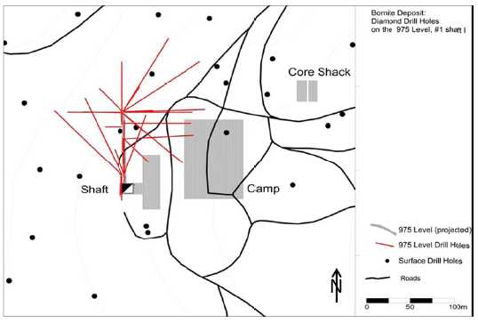
Bruce Davis conducted a site visit to the Bornite Project on July 26-27, 2011, and again on September 25, 2012. Figure 2.1 shows the Bornite exploration shaft and the NovaCopper exploration camp. The site visits included a review of: drilling procedures, site facilities, historic and recent drill core, logging procedures, data capture, and sample handling. During the 2012 Bornite site visit, Mr. Davis undertook a helicopter traverse along proposed access corridors and within the UKMP. |
Figure 2.1: Bornite Exploration Shaft and the NovaCopper Exploration Camp
![]()
| 2.5 |
INFORMATION SOURCES |
|
Reports and documents listed in Section 27.0 were used to support the preparation of the technical report. Additional information was sought from NovaCopper personnel where required. |
| NovaCopper Inc. | 2-6 | |
| NI 43-101 Technical Report on the Bornite Project, | ||
| Northwest Alaska |
| 3.0 |
RELIANCE ON OTHER EXPERTS |
BDRC and SGI have fully relied on NovaCopper’s management team for matters relating to mineral tenure and mining rights permits, surface rights, royalties, agreements and encumbrances relevant to this report, which are documented in the NovaCopper and NANA Exploration Agreement and Option to Lease dated October 19, 2011 (the “NANA Agreement”). BDRC and SGI have not researched the property title or mineral rights for the Bornite Project and express no legal opinion as to the ownership status of the property.
BDRC and SGI believe the data and information provided by NovaCopper is essentially complete and correct to the best of their knowledge and that no information was intentionally withheld that would affect the conclusions made herein.
| NovaCopper Inc. | 3-7 | |
| NI 43-101 Technical Report on the Bornite Project, | ||
| Northwest Alaska |
| 4.0 |
PROPERTY DESCRIPTION AND LOCATION |
| 4.1 |
LOCATION |
|
The Property is part of the UKMP mineral tenure package, which includes the Bornite Deposit, as well as numerous additional mineral showings/deposits (Figure 4.1 and Figure 4.2). The Property is located in the Ambler mining district of the southern Brooks Range, in the NWAB of Alaska. The Property is located in Ambler River A-2 quadrangle, Kateel River Meridian T 19N, R 9E, sections 4, 5, 8 and 9. | |
|
The Bornite Project is located 248 km east of the town of Kotzebue, 19 km north of the village of Kobuk, 275 km west of the Dalton Highway, an all-weather state maintained public road, at geographic coordinates N67.07° latitude and W156.94° longitude (Universal Transverse Mercator (UTM) North American Datum (NAD) 83, Zone 4W coordinates 7440449N, 589811E). | |
| 4.2 |
MINERAL TENURE |
|
The UKMP lands consist of NANA owned patented lands, NANA selected ANCSA lands, State of Alaska mining claims, and patented land owned by NovaCopper. The total land tenure package consists of 142,831 ha, 140,500 ha of which are within the NANA/NovaCopper “Area of Interest” covered by the NANA/NovaCopper Agreement. Twenty contiguous State of Alaska mining claims totaling 2,331 ha are outside of the NANA/NovaCopper Area of Interest. A breakdown of the UKMP lands is provided in Table 4.1. |
Table 4.1: Summary of UKMP Lands Status
| Owner | Number | Type | Acres | Hectares |
| NovaCopper | 1336 | State Claims (inside AOI) | 106,026 | 42,907 |
| NovaCopper | 20 | State Claims (outside AOI) | 5,760 | 2,331 |
| NovaCopper | 2 | Patented | 272 | 110 |
| NovaCopper Total | 112,058 | 45,348 | ||
| NANA (ANCSA) | N/A | Selected/Patented | 240,369 | 97,274 |
| NANA (Bornite) | 25 (2 USMS Patents) |
Patented | 517 | 209 |
| NANA Total | 240,885 | 97,483 | ||
| Grand Total | 352,943 | 142,831 |
| NovaCopper Inc. | 4-8 | |
| NI 43-101 Technical Report on the Bornite Project, | ||
| Northwest Alaska |
Figure 4.1: Upper Kobuk Mineral ProjectsLands (NovaCopper, 2014)
![]()
| NovaCopper Inc. | 4-9 | |
| NI 43-101 Technical Report on the Bornite Project, | ||
| Northwest Alaska |
Figure 4.2: Mineral Tenure Plan (NovaCopper,2014)
| NovaCopper Inc. | 4-10 | |
| NI 43-101 Technical Report on the Bornite Project, | ||
| Northwest Alaska |
| 4.3 | ROYALTIES, AGREEMENTS AND ENCUMBRANCES |
| 4.3.1 | KENNECOTT AGREEMENTS |
|
On March 22, 2004, Alaska Gold Company, a wholly-owned subsidiary of NovaGold Resources Inc. (NovaGold) completed an Exploration and Option to Earn an Interest Agreement with Kennecott Exploration Company and Kennecott Arctic Company (collectively, Kennecott) on the Ambler land holdings. | |
|
On December 18, 2009, a Purchase and Termination Agreement was entered into between Alaska Gold Company and Kennecott whereby NovaGold agreed to pay Kennecott a total purchase price of $29 million for a 100% interest in the Ambler land holdings, which included the Arctic Project, to be paid as: $5 million by issuing 931,098 NovaGold shares, and two installments of $12 million each, due 12 months and 24 months from the closing date of January 7, 2010. The NovaGold shares were issued in January 2010, the first $12 million payment was made on January 7, 2011, and the second $12 million payment was made in advance on August 5, 2011; this terminated the March 22, 2004 exploration agreement between NovaGold and Kennecott. Under the Purchase and Termination Agreement, the seller retained a 1% net smelter return (NSR) royalty that is purchasable at any time by the land owner for a one-time payment of $10 million. | |
|
During 2011, NovaGold incorporated the NovaCopper entities and transferred its Ambler land holdings, including the Arctic Project from Alaska Gold Company to NovaCopper US Inc. In April 2012, NovaGold completed a spin-out of NovaCopper, with the Ambler lands, to the NovaGold shareholders and made NovaCopper an independent publically listed company, listed on the TSX and NYSE-MKT exchanges. | |
| 4.3.2 |
NANA AGREEMENT |
|
In 1971, the US Congress passed the Alaska Native Claims Settlement Act (ANCSA) which settled land and financial claims made by the Alaska Natives and provided for the establishment of 13 regional corporations to administer those claims. These 13 corporations are known as the Alaska Native Regional Corporations (ANCSA Corporations). One of these 13 regional corporations is the Northwest Alaska Native Association (NANA) Regional Corporation, Inc. ANCSA Lands controlled by NANA bound the southern border of the Property claim block. National Park lands are within 25 km of the northern property border. The Bornite Deposit is located entirely on lands owned by NANA. | |
|
On October 19, 2011, NovaCopper and NANA Regional Corporation, Inc. entered into the “NANA Agreement” for the cooperative development of their respective resource interests in the Ambler mining district. The NANA Agreement consolidates NovaCopper’s and NANA’s land holdings into an approximately 142,831 ha land package and provides a framework for the exploration and development of the area. The NANA Agreement provides that NANA will grant NovaCopper the nonexclusive right to enter on, and the exclusive right to explore, the Bornite Lands and the ANCSA Lands (each as defined in the NANA Agreement) and in connection therewith, to construct and utilize temporary access roads, camps, airstrips and other incidental works. The NANA Agreement has a term of 20 years, with an option in favour of NovaCopper to extend the term for an additional 10 years. The NANA Agreement may be terminated by mutual agreement of the parties or by NANA if NovaCopper does not meet certain expenditure requirements on NANA’s lands. |
| NovaCopper Inc. | 4-11 | |
| NI 43-101 Technical Report on the Bornite Project, | ||
| Northwest Alaska |
If, following receipt of a feasibility study and the release for public comment of a related draft environmental impact statement, NovaCopper decides to proceed with construction of a mine on the lands subject to the NANA Agreement, NovaCopper will notify NANA in writing and NANA will have 120 days to elect to either (a) exercise a non-transferrable back-in-right to acquire between 16% and 25% (as specified by NANA) of that specific project; or (b) not exercise its back-in-right, and instead receive a net proceeds royalty equal to 15% of the net proceeds realized by NovaCopper from such project. The cost to exercise such back-in-right is equal to the percentage interest in the Project multiplied by the difference between (i) all costs incurred by NovaCopper or its affiliates on the project, including historical costs incurred prior to the date of the NANA Agreement together with interest on the historical costs; and (ii) $40 million (subject to exceptions). This amount will be payable by NANA to NovaCopper in cash at the time the parties enter into a joint venture agreement and in no event will the amount be less than zero.
In the event that NANA elects to exercise its back-in-right, the parties will, as soon as reasonably practicable, form a joint venture with NANA electing to participate between 16% to 25%, and NovaCopper owning the balance of the interest in the joint venture. Upon formation of the joint venture, the joint venture will assume all of the obligations of NovaCopper and be entitled to all the benefits of NovaCopper under the NANA Agreement in connection with the mine to be developed and the related lands. A party’s failure to pay its proportionate share of costs in connection with the joint venture will result in dilution of its interest. Each party will have a right of first refusal over any proposed transfer of the other party’s interest in the joint venture other than to an affiliate or for the purposes of granting security. A transfer by either party of a net smelter royalty return on the project or any net proceeds royalty interest in a project other than for financing purposes will also be subject to a first right of refusal.
In connection with possible development on the Bornite Lands or ANCSA Lands, NovaCopper and NANA will execute a mining lease to allow NovaCopper or the joint venture to construct and operate a mine on the Bornite Lands or ANCSA Lands (the “Mining Lease”). These leases will provide NANA a 2% net smelter royalty as to production from the Bornite Lands and a 2.5% net smelter royalty as to production from the ANCSA Lands.
If NovaCopper decides to proceed with construction of a mine on its own lands subject to the NANA Agreement, NANA will enter into a surface use agreement with NovaCopper which will afford NovaCopper access to the project along routes approved by NANA (the “Surface Use Agreement”). In consideration for the grant of such surface use rights, NovaCopper will grant NANA a 1% net smelter royalty on production and an annual payment of $755 per acre (as adjusted for inflation each year beginning with the second anniversary of the effective date of the NANA Agreement and for each of the first 400 acres (and $100 for each additional acre) of the lands owned by NANA and used for access which are disturbed and not reclaimed.
| NovaCopper Inc. | 4-12 | |
| NI 43-101 Technical Report on the Bornite Project, | ||
| Northwest Alaska |
| 4.4 |
ENVIRONMENTALLIABILITIES |
|
Under the NANA Agreement, NANA is required to complete a baseline environmental report following the cleanup of the former mining camp on the Bornite Lands; this work must be completed to Alaska Department of Environmental Conservation standards. Cleanup includes the removal and disposal, as required by law, of all hazardous substances present on the Bornite Lands. NANA has indemnified and will hold NovaCopper harmless for any loss, cost, expense, or damage suffered or incurred attributable to the environmental condition of the Bornite Lands at the date of the baseline report which relate to any activities prior to the date of the agreement. | |
|
In addition, there are no indications of any known environmental impairment or enforcement actions associated with NovaGold’s activities to date. As a result, NovaGold, now NovaCopper has not incurred outstanding environmental liabilities in conjunction with its entry into the NANA Agreement. | |
| 4.5 |
PERMITS |
|
Multiple permits are required during the exploration phase of the Property. Permits are issued from Federal, State, and Regional agencies, including: the Environmental Protection Agency (EPA), the US Army Corps of Engineers (USACE), the Alaska Department of Environmental Conservation (ADEC), the Alaska Department of Fish and Game (ADF&G), the Alaska Department of Natural Resources (ADNR), and the NWAB. The State of Alaska permit for exploration on the Property, the Annual Hardrock Exploration Activity (AHEA) Permit, is obtained and renewed every five years through the ADNR – Division of Mining, Land and Water. NovaCopper holds an AHEA exploration permit in good standing with the Alaska DNR, and has done so each year since 2004 under Alaska Gold Company, a wholly owned subsidiary of NovaGold and now NovaCopper. The Property is within the NWAB thus requiring a Title 9 Miscellaneous Land Use permit for mineral exploration, fuel storage, gravel extraction, and the operation of a landfill. NovaGold held these permits in good standing during the 2004 to 2008 seasons and renewed the permits for the 2010 exploration season to 2015. The Bornite Camp, Bornite Landfill, Dahl Creek Camp, and the to-be-constructed Arctic Camp are permitted by the ADEC. | |
|
A number of statutory reports and payments are required to maintain the claims in good standing on an annual basis. As the Bornite Project progresses, additional permits for environmental baseline and detailed engineering studies will be necessary at federal, state, and local levels. A detailed outline of permitting requirements is discussed in Section 20.0. |
| NovaCopper Inc. | 4-13 | |
| NI 43-101 Technical Report on the Bornite Project, | ||
| Northwest Alaska |
| 5.0 |
ACCESSIBILITY, CLIMATE, LOCAL RESOURCES, |
| 5.1 |
ACCESSIBILITY |
| 5.1.1 |
AIR |
|
Primary access to the Property is by air, using both fixed wing aircraft and helicopters. | |
|
There are four well maintained, approximately 1,500 m-long gravel airstrips located near the Property, capable of accommodating charter fixed wing aircraft. These airstrips are located 40 km west at Ambler, 23 km southwest at Shungnak, 19 km south at Kobuk, and 15 km south at Dahl Creek. There is daily commercial air service from Kotzebue to the village of Kobuk, the closest community to the Property. During the summer months, the Dahl Creek Camp airstrip is suitable for larger aircraft, such as C-130 and DC-6. | |
|
In addition to the four 1,500 m airstrips, there is a 700 m airstrip located at the Bornite Camp. The airstrip at Bornite is suited to smaller aircraft, which support the Bornite Camp with personnel and supplies. | |
| 5.1.2 |
WATER |
|
There is no direct water access to the Property. During spring runoff, river access is possible by barge from Kotzebue Sound to Ambler, Shungnak, and Kobuk via the Kobuk River. | |
| 5.1.3 |
ROAD |
|
A one-lane dirt track suitable for high-clearance vehicles or construction equipment links the Bornite Project’s main camp to the 400 m Dahl Creek airstrip and village of Kobuk. | |
| 5.2 |
CLIMATE |
|
The climate in the region is typical of a sub-arctic environment. Exploration is generally conducted from late May until late September. Weather conditions on the Property can vary significantly from year to year and can change suddenly. During the summer exploration season, average maximum temperatures range from 10°C to 20°C, while average lows range from -2°C to 7°C (Alaska Climate Summaries: Kobuk 1971 to 2000). By early October, unpredictable weather limits safe helicopter travel to the Property. During winter months, the Property can be accessed by snow machine, track vehicle, or fixed wing aircraft. Winter temperatures are routinely below -25°C and can exceed - 50°C. Annual precipitation in the region averages at 395 mm with the most rainfall occurring from June through September, and the most snowfall occurring from November through January. |
| NovaCopper Inc. | 5-14 | |
| NI 43-101 Technical Report on the Bornite Project, | ||
| Northwest Alaska |
| 5.3 |
LOCAL RESOURCES |
|
The Property is approximately 248 km east of the town of Kotzebue, on the edge of Kotzebue Sound, 19 km north of the village of Kobuk, 275 km west of the Dalton Highway, and 485 km northwest of Fairbanks. Kobuk (population 151; 2010 US Census) is a potential workforce source for the Bornite Project, and is the location of one of the airstrips near the Property. Several other villages are also near the Property, including Shungnak located 23 km to the southwest with a population of 262 (2010 US Census) and Ambler, 40 km to the west with a population of 258 (2010 US Census). Kotzebue has a population of 3,201 (2010 US Census) and is the largest population centre in the Northwest Arctic Borough. Kotzebue is a potential source of limited mining-related supplies and labourers, and is the nearest centre serviced by regularly scheduled, large commercial aircraft (via Nome or Anchorage). In addition, there are seven other villages in the region that will be a potential source of some of the workforce for the Property. Fairbanks (population 32,036; 2011 US Census) has a long mining history and can provide most mining-related supplies and support that cannot be sourced closer to the Property. | |
|
Drilling and mapping programs are seasonal and have been supported out of the Main Bornite Camp and Dahl Creek Camp. The main Bornite Camp facilities are located on Ruby Creek on the northern edge of the Cosmos Hills. The camp provides office space and accommodations for the geologists, drillers, pilots, and support staff. There are four 2-person cabins installed by NANA prior to NovaCopper’s tenure. | |
|
In 2011, the main Bornite Camp was expanded to 20 sleeping tents, 3 administrative tents, 2 shower/bathroom tents, 1 medical tent, and 1 dining/cooking tent. With these additions, the camp capacity was increased to 49 beds. A 30 m by 9 m core logging facility was also built in summer of 2011. An incinerator was installed near the Bornite airstrip to manage waste created by the Bornite Project. Power for the Bornite Project is supplied by a 175 kW Caterpillar diesel generator. Water is provided by a permitted artesian well located 250 m from the Bornite Camp. | |
|
In 2012, the camp was further expanded with the addition of a laundry tent, a women's shower/washroom tent, a recreation tent, several additional sleeping tents, and a 2 x enlargement of the kitchen tent. Camp capacity increased to 76 beds. The septic field was upgraded to accommodate the increase in camp population. One of the two-person cabins was winterized for use by the winter caretaker. A permitted landfill was established to allow for the continued cleanup and rehabilitation of the historic shop facilities and surroundings. | |
|
The Dahl Creek camp is an overflow or alternative facility to the main Bornite Camp. The Dahl Creek camp has a main cabin for dining and administrative duties, and a shower facility. Sleeping facilities include two hard-sided sleeping cabins with seven beds (primarily used for staff), two 4-person sleeping tents, and three 2-person sleeping tents for a total of 21 beds. There are support structures, including a shop and storage facilities. |
| NovaCopper Inc. | 5-15 | |
| NI 43-101 Technical Report on the Bornite Project, | ||
| Northwest Alaska |
| 5.4 |
INFRASTRUCTURE |
|
Proposed infrastructure is discussed in more detail in Section 18.0. Currently, the Bornite Project does not have access to Alaska power and transportation infrastructure. | |
|
Beginning in 2009, the Property has been the focus of an access corridor study. The State of Alaska has spent approximately $10 million to identify proposed access routes to the Ambler mining district, and to initiate environmental baseline studies. The working group for this study consists of the Alaska Department of Transportation (ADOT), the ADNR, the Governor’s Office, the Alaska Industrial Development and Export Authority (AIDEA), NANA, and NovaCopper. | |
|
Based on this work the Brooks East route has been selected as the preferred alternative. It is a 322 km road running east from the Property to the Dalton Highway and is now referred to as the Ambler Mining District Industrial Access Road or AMDIAR. The environmental baseline study for the route is expected to be completed in 2013, with the environmental impact study to follow in early 2014. A budget of $8.5M has been committed for 2013/2014 to support pre-design and environmental permitting. A budget of $10M has been proposed for 2014/2015 to support environmental studies, legal and permitting the preferred access route. | |
| 5.5 |
PHYSIOGRAPHY |
|
The Bornite Project is located on Ruby Creek on the northern edge of the Cosmos Hills. The Cosmos Hills are part of the southern flank of the Brooks Range in Northwest Alaska. Topography in the area is moderately rugged. Maximum relief in the Cosmos Hills is approximately 1,000 masl with an average of 600 masl. Talus covers the upper portions of the hills; glacial and fluvial sediments occupy valleys. | |
|
The Kobuk Valley is located at the transition between boreal forest and Arctic tundra. Spruce, birch, and poplar are found in portions of the valley, with a ground cover of lichens (reindeer moss). Willow and alder thickets and isolated cottonwoods follow drainages, and alpine tundra is found at higher elevations. Tussock tundra and low, heath-type vegetation covers most of the valley floor. Patches of permafrost exist on the Property. | |
|
Permafrost is a layer of soil at variable depths beneath the surface where the temperature has been below freezing continuously from a few to several thousands of years (Climate of Alaska 2007). Permafrost exists where summer heating fails to penetrate to the base of the layer of frozen ground and occurs in most of the northern third of Alaska as well as in discontinuous or isolated patches in the central portion of the state. |
| NovaCopper Inc. | 5-16 | |
| NI 43-101 Technical Report on the Bornite Project, | ||
| Northwest Alaska |
|
Wildlife in the Property area is typical of Arctic and Subarctic fauna (Kobuk Valley National Park 2007). Larger animals include caribou, moose, Dall sheep, bears (grizzly and black), wolves, wolverines, coyotes, and foxes. Fish species include salmon, sheefish, arctic char, and arctic grayling. The Kobuk River, which briefly enters the UKMP on its southwest corner, is a significant salmon spawning river. The Caribou on the Property belong to the Western Arctic herd that migrates twice a year – south in August, from their summer range north of the Brooks Range, and north in March from their winter range along the Buckland River. | |
| 5.6 |
SUFFICIENCY OF SURFACE RIGHTS |
|
The Company has sufficient surface rights for its planned mining operations including sufficient land to construct various facilities such as tailings storage areas, potential waste disposal areas, potential stockpile areas and potential processing plants. |
| NovaCopper Inc. | 5-17 | |
| NI 43-101 Technical Report on the Bornite Project, | ||
| Northwest Alaska |
| 6.0 |
HISTORY |
|
Regional exploration began in the early 1900s when gold prospectors noted copper occurrences in the hills north of Kobuk, Alaska. In 1947, local prospector Rhinehart “Rhiny” Berg along with various partners traversing in the area located outcropping mineralization along Ruby Creek (Bornite) on the north side of the Cosmos Hills. They subsequently staked claims over the Ruby Creek showings and constructed an airstrip for access. In 1957, BCMC, Kennecott's exploration subsidiary, optioned the property from Berg. | |
|
Exploration drilling in 1961 and 1962 culminated in the discovery of the “No.1 Ore Body” where drill hole RC-34 cut 20 m of 24% copper (the “No.1 Ore Body” is a historic term used by BCMC that does not connote economic viability in the present context; it is convenient to continue to use the term to describe exploration work and historic resource estimation in a specific area of what is now generally known as Ruby Creek Upper Reef). The discovery of the “No.1 Ore Body” led to the development of an exploration shaft in 1966. The shaft, which reached a depth of 328 m, encountered a significant watercourse and was flooded near completion depth. The shaft was subsequently dewatered and an exploration drift was developed to provide access for sampling and mapping, and to accommodate underground drilling to further delineate mineralization. A total of 59 underground holes were drilled and, after the program, the shaft was allowed to re-flood. | |
|
The discovery of the Arctic Project in 1965 prompted a hiatus in exploration at Bornite, and only limited drilling occurred up until 1976. | |
| 6.1 |
GEOCHEMISTRY |
|
In the late 1990s, Kennecott resumed its evaluation of the Bornite deposit and the mineralization in the Cosmos Hills with an intensive soil, stream, and rock chip geochemical sampling program using 32 element ICP analyses. Grid soil sampling yielded 765 samples. Ridge and spur sampling resulted in an additional 850 soil samples in the following year. Skeletonized core samples (85 samples) from key historic drill holes were also analyzed using 32 element ICP analytical methods. Geochemical sampling identified multiple areas of elevated copper and zinc in the Bornite region (Kennecott Annual Ambler Project Reports, 1995-1997). | |
| 6.2 |
GEOPHYSICS |
|
Kennecott completed numerous geophysical surveys as an integral part of exploration throughout their tenure on the property. Various reports, notes, figures, and data files stored in Kennecott’s Salt Lake City exploration office indicated that geophysical work included, but was not limited to, the following: |
| NovaCopper Inc. | 6-18 | |
| NI 43-101 Technical Report on the Bornite Project, | ||
| Northwest Alaska |
| • |
Airborne magnetic and electromagnetic (EM) surveys (fixed-wing INPUT) (1950s) | |
| • |
Gravity, single point (SP), Audio-Frequency Magneto-Telluric (AMT), EM, borehole and surface IP/resistivity surveys (1960s) | |
| • |
Gravity, airborne magnetic, and Controlled Source Audio-frequency Magneto- Telluric (CSAMT) surveys (1990s) |
NovaCopper has little information or documentation associated with these geophysical surveys conducted prior to the 1990s. Where data are available in these earlier surveys, the lack of details in data acquisition, coordinate systems, and data reduction procedures limit their usefulness. The only complete geophysical report available concerns down-hole IP/resistivity results (Merkel, 1967).
Most notable is the 1996 Bouger gravity survey from the Bornite deposit into the Ambler lowlands. Figure 6.1 shows the terrain-corrected Bouger residual gravity survey anomalies. The Bornite deposit itself is seen as a significant 3 milligal anomaly. Numerous 2 milligal to > 6 milligal anomalies occur under cover in the Ambler lowlands and near the Aurora Mountain and Pardner Hill occurrences.
The wide range of geophysical techniques used in and around the deposit over a span of 40 years indicates the level of difficulty experienced by Kennecott/BCMC while trying to detect mineralization. When applying EM and IP/resistivity methods, the problem appears to be that deeper mineralization is often masked by the response of near-surface conductive rocks.
In addition to the geophysical surveys conducted by Kennecott, the Alaska Department of Natural Resources and Geometries completed an aeromagnetic survey of portions of the Ambler mining district in 1974-1975. Part of this survey is reproduced in Figure 9.3 (Gilbert et al., 1977).
| NovaCopper Inc. | 6-19 | |
| NI 43-101 Technical Report on the Bornite Project, | ||
| Northwest Alaska |
Figure 6.1: 1996 Kennecott Residual Gravity
| 6.3 | DRILLING AND UNDERGROUND WORKINGS |
Between 1957 and 1976, Kennecott
(BCMC) completed 178 holes (including 51 underground holes) totaling
47,801 m. In 1997, Kennecott drilled an additional 3 core holes totaling
928 m. | |
Drilling for all BCMC/Kennecott
campaigns in the Bornite Deposit area (1957 to 1997) totals 181 core holes
for a combined 48,729 m. A complete and comprehensive discussion of all
the drilling undertaken at the Bornite Deposit is contained in Section
10.0 of this report. | |
In October 1965, Kennecott began
a shaft to further investigate the Ruby Creek Upper Reef “No.1 Ore Body”
mineralization. In 1966, the shaft reached the 297 m (975 ft) level. At
this level, a 91 m crosscut was driven due north to the mineralized zone.
The shaft was continued to 328 m (1,075 ft) deep to prepare a sump and
loading pocket. On October 27, 1966, a small blast to excavate a bay at
the bottom of the shaft opened a watercourse. The in-flood of water
quickly exceeded the pump capacity and within 12 hours the 328 m shaft was
flooded to within 13 m from the surface (Hawke, 1966). | |
Prior to the shaft flooding, six
diamond drill holes were completed from the 700 level shaft station and 22
drill holes from the 975 shaft station and crosscut. In 1967, the shaft
bottom was partially sealed and then pumped out, and an additional 24
holes were drilled from the 700 level and the 975 level shaft stations.
Figure 6.2 and Figure 6.3 show underground diamond drilling from the 700
and 975 levels. |
| NovaCopper Inc. | 6-20 | |
| NI 43-101 Technical Report on the Bornite Project, | ||
| Northwest Alaska |
Figure 6.2: Diamond Drilling from the 700 Level of the No. 1 Shaft
![]()
Figure 6.3: Diamond Drilling from the 975 Level of the No. 1 Shaft
| NovaCopper Inc. | 6-21 | |
| NI 43-101 Technical Report on the Bornite Project, | ||
| Northwest Alaska |
| 6.4 |
PETROLOGY, MINERALOGY, AND RESEARCH STUDIES |
|
Several studies have been undertaken reviewing the geology and geochemistry of the Bornite deposit. Most notable is Murray Hitzman’s PhD dissertation at Stanford University (Hitzman, 1983) and Don Runnel’s PhD dissertation at Harvard University (Runnels, 1963). Bernstein and Cox reported on mineralization of the “No. 1 Ore Body” in a 1986 paper in Economic Geology (Bernstein et al, 1986). | |
|
In addition to the historical work, Ty Connor at the Colorado School of Mines is currently undertaking an MSc thesis study on the breccias and mineralization at Bornite. | |
| 6.5 |
GEOTECHNICAL AND HYDROLOGICAL STUDIES |
|
Kennecott conducted two technical reviews of the groundwater conditions (Vance, 1962) and a summary of the findings related to the flooding of the exploration shaft (Erskine, 1970). | |
| 6.6 |
METALLURGICAL STUDIES |
|
In 1961, Kennecott collected 32 coarse reject samples from five drill holes to support preliminary metallurgical test work at Bornite. Samples targeted high-grade (> 10%) copper mineralization from the Upper Reef at Ruby Creek (Lutz, 1961). An extensive discussion of the historic and current metallurgical studies is presented in Section 13.0 of this report. | |
| 6.7 |
HISTORICAL MINERAL RESOURCE ESTIMATES |
|
All of the historical mineral resource estimates presented below were made prior to the implementation of NI 43-101. They do not conform to NI 43-101 reporting standards and should not be relied upon or interpreted as such. A QP has not done sufficient work to classify the historical estimates as current mineral resources and NovaCopper is not treating the historical estimates as current mineral resources. They are presented here for information purposes only. | |
|
LUND (1961) | |
|
The earliest and most widely repeated resource number reported 91 million tons at 1.2% Cu in an unconstrained polygonal resource estimate. At a constrained 1% Cu cut-off grade, 21.2 million tons of 3.04% Cu and at a 2.5% Cu cut-off, 5.2 million tons of 5.83% Cu were reported. The estimation is based on an 11.0 ft3/ton tonnage factor for the Lower Reef or lower grade mineralization and a 10.0 ft3/ton tonnage factor for the higher grade Upper Reef mineralization. It is not known if the tonnage factors were based on any direct specific gravity measurements of the Bornite drill core. Metals such as silver and cobalt were not considered in any of the historical estimations. |
| NovaCopper Inc. | 6-22 | |
| NI 43-101 Technical Report on the Bornite Project, | ||
| Northwest Alaska |
C.T.PENNEY (1968)
This estimate is restricted to the “No.1 Ore Body” in the Ruby Creek Upper Reef. The reported resource is 180,000 - 200,000 tons at 8.4% Cu.
REED (1971)
This estimate is (apparently) tabulated using an unknown grade times thickness (copper x thickness) cut-off criterion. It includes both Ruby Creek Upper Reef and Lower Reef mineralization with a reported total of 35.7 M tons at 2.15% Cu.
SICHERMANN (1974)
This estimate utilized a polygonal methodology and is not considered entirely accurate as down-hole surveys were not available for all drill holes and mineralization lenses were observed to be erratic. A 10.5 ft3/ton tonnage factor for >1% Cu mineralization and an 8.0 ft3/ton tonnage factor for >4% Cu mineralization was applied. Two different resource estimates are reported: 5 million tons (4.56 million tonnes) at 4% Cu and 40 million tons (36.2 million tonnes) at 2% Cu, respectively, without reporting cut-off grades.
KENNECOTT (1997)
In 1997, Macfarlane conducted a more rigorous resource estimation of the Ruby Creek (Bornite) deposit. This estimation used VulcanTM 3D modeling and resource estimation software. A series of grade shells at 0.2%, 0.5% and 1.0% copper were manually constructed on sections and imported into Vulcan. Within each shell, separate resource calculations at 0.5%, 1.0%, 2%, and 4.0% copper cut-off grades were made. The grade shells were constructed irrespective of various lithology or mineralization styles. Attempts to create meaningful semi-variograms for copper mineralization were reportedly unsuccessful. An inverse distance squared weighting methodology was used to estimate the resource. Results are shown in Table 6.1.
Table 6.1: Bornite (Ruby Creek) Historica lResource (Kennecott, 1997)
| Cut-off | 0.2% Grade shell | 0.5% Grade shell | 1% Grade shell | |||
| (% Cu) | Tonnage (M tonnes) |
Grade (Cu %) |
Tonnage (M tonnes) |
Grade (Cu %) |
Tonnage (M tonnes) |
Grade (Cu %) |
| 0.5 | 71.6 | 1.24 | 40.5 | 1.41 | 17.1 | 2.02 |
| 1.0 | 27.0 | 2.09 | 22.3 | 1.92 | 14.2 | 2.26 |
| 2.0 | 6.6 | 4.48 | 4.7 | 4.02 | 4.0 | 4.39 |
| 4.0 | 2.2 | 8.06 | 1.5 | 7.15 | 1.1 | 9.54 |
| NovaCopper Inc. | 6-23 | |
| NI 43-101 Technical Report on the Bornite Project, | ||
| Northwest Alaska |
In an absence of actual measured densities, an approximation of the specific gravity, based on the relationship of copper grade to specific gravity, was used by Kennecott. No support for this approach was presented. Macfarlane noted, using the method, tonnages for massive pyrite areas with low grade copper were significantly underestimated.
| NovaCopper Inc. | 6-24 | |
| NI 43-101 Technical Report on the Bornite Project, | ||
| Northwest Alaska |
| 7.0 |
GEOLOGICAL SETTING AND MINERALIZATION |
| 7.1 | REGIONAL GEOLOGY |
|
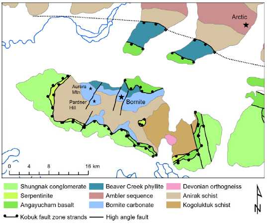
The Bornite Project is located within the Arctic Alaska Terrane, a sequence of mostly Paleozoic continental margin rocks that make up the Brooks Range and North Slope of Alaska (Moore, 1992). It is within the Phyllite Belt geologic subdivision, which together with the higher-grade Schist Belt, stretches almost the entire length of the Brooks Range and is considered to represent the hinterland of the Jurassic Brooks Range orogeny. The southern margin of the Phyllite Belt is marked by mélange and low angle faults associated with the Kobuk River fault zone, while the northern boundary is thought to be gradational with the higher-grade metamorphic rocks of the Schist Belt (Till et al., 2008). | |
| 7.2 |
TECTONIC AND METAMORPHIC HISTORY |
|
The tectonic setting of the project area during mineralization (early Devonian) has been masked by subsequent deformation and remains poorly understood. Dillon et al. (1980) interpret the existence of Devonian granites throughout the Brooks Range as supporting a volcanic arc environment, while Hitzman et al. (1986) point to bimodal volcanic rocks and abrupt sedimentary facies transitions as supporting an extensional tectonic setting. Based on igneous geochemistry, Ratterman et al. (2006) suggest that the Ambler sequence volcanic rocks were emplaced in an extensional back-arc spreading environment; however, the original pre-deformation spatial relationship between the Bornite Project area and the Ambler sequence is still poorly understood. | |
|
The project area underwent regional deformation and metamorphism during the Middle Jurassic to Early Cretaceous Brooks Range orogeny. The collision of the Koyukuk Arc Terrane from present-day south caused north-directed imbrication and partial subduction of the Arctic Alaska passive margin sedimentary sequence. Rocks in the Schist Belt were metamorphosed to blueschist facies but were partially exhumed by north-directed faulting prior to full thermal equilibration. Both the Schist Belt and the Phyllite Belt cooled from greenschist conditions during a period of rapid extension and erosion beginning around 103 Ma (Moore et al., 1994, Vogl et al., 2003). | |
|
In the project area, a strand of the Kobuk fault zone separates the Cosmos Hills stratigraphy (Schist Belt and Phyllite Belt) from the overlying Angayucham Terrane, and another strand may separate Cosmos Hills from the Ambler sequence to the north (Figure 7.1). |
| NovaCopper Inc. | 7-25 | |
| NI 43-101 Technical Report on the Bornite Project, | ||
| Northwest Alaska |
Figure 7.1: Generalized Geologic Map of the Cosmos Hills (Modified from Till etal., 2008)
| 7.2.1 |
REGIONAL STRATIGRAPHY |
|
The autochthonous stratigraphy of the district is characterized by lower greenschist to epidote-amphibolite facies, pelitic, carbonate, and local metavolcanic rocks as shown in Figure 7.1 and summarized in Table 7.1. |
| NovaCopper Inc. | 7-26 | |
| NI 43-101 Technical Report on the Bornite Project, | ||
| Northwest Alaska |
Table 7.1: Stratigraphic Units of the Cosmos Hills Area (modified from Hitzman etal., 1986 )
| Unit (age) | Lithology | Metamorphic grade | Approximate thickness |
| Shungnak conglomerate (Cretaceous) | Pebble conglomerate, sandstone, siltstone, minor intermediate volcanics | Unmetamorphosed | 1000m |
| Angayucham terrane (Devonian- Mississippian) (allochthonous) | Pillow basalt, pillow breccia | Prehnite-Pumpellyite | >500m |
| Beaver Creek phyllite (Devonian*) | Phyllite, quartzite, marble | Lower Greenschist | >2000m |
| Ambler sequence (Devonian*) | Metarhyolite, metabasite, tuffaceous metasediments, calcareous metasediments, pelitic schist | Blueschist to Greenschist | 700-1850m |
| Bornite carbonate sequence (Lower Devonian to Upper Silurian*) | Marble, argillaceous marble, dolostone, phyllite, phyllitic marble | Lower Greenschist | 200-1000m |
| Anirak schist (Devonian*) | Pelitic schist, quartzite, marble, minor metabasite | Greenschist | 3000m |
| Kogoluktuk schist (Precambrian to Devonian*) | Pelitic schist, quartzite, metagabbro, minor marble | Epidote-Amphibolite | 4000m |
*Ages from Till et al., 2008
| 7.2.2 |
IGNEOUS ROCKS |
|
The intersection of the Cosmos Arch and the Kogoluktuk River drainage 14 km southeast of Bornite exposes a cataclastic orthogneiss of granitic composition which intrudes the Kogoluktuk Schist. Zircons return a syn-mineral uranium-lead age of 386 ± 3 Ma (Till et al., 2008, citing W.C. McClelland). | |
|
Higher in the section, the Kogoluktuk Schist is also intruded by sill-form metagabbro bodies of unknown age. Other metamafic ‘greenstones’ are interpreted to have originated as flows and/or tuffaceous sediments (Hitzman, 1986). | |
|
Although none occur in the Bornite resource area, discontinuous stratabound greenstone bodies occur in the Anirak Schist and at the base of the Bornite carbonate sequence, particularly west and southwest of Bornite (Hitzman et al., 1982). A gabbroic outcrop approximately 200 m in width outcrops 2 km east of Bornite and is interpreted to be Cretaceous to Tertiary in age. | |
|
The most significant igneous rocks in the district are the bimodal volcanic rocks of the Ambler sequence—host of the Ambler VMS district—which outcrop 20 km north of Bornite, but are not observed in the Cosmos Hills (Table 7.1). These include sub-alkaline basaltic flows and sills with an un-depleted mantle geochemical signature. Sub-alkaline rhyolitic to andesitic tuffs and flows have geochemistry consistent with formation from a source that includes melting continental crust. Geochemistry collectively implies origin in an extensional, back-arc basin setting (Ratterman et al., 2006). Uranium-lead zircon dating from Ambler sequence metarhyolites returns ages of 376-387 Ma (McClelland et al., 2006), which are syn- to early post-mineral with respect to the Bornite (Ruby Creek) deposit. |
| NovaCopper Inc. | 7-27 | |
| NI 43-101 Technical Report on the Bornite Project, | ||
| Northwest Alaska |
| 7.2.3 |
TIMING OF MINERALIZATION IN THE DISTRICT |
|
Sulphide mineralization (chalcopyrite, pyrite, and bornite) from Bornite (Ruby Creek) was dated by Re-Os techniques (Selby et al., 2009), producing an age of 384 ± 4.2 Ma for main stage copper mineralization. | |
|
The syngenetic VMS deposits in the Ambler sequence are constrained by dating of related felsic volcanic rocks. Early post-mineral metarhyolite at the Arctic deposit yielded a mean uranium-lead zircon age of 378 ± 2Ma. Uranium-lead zircon ages for metarhyolite at the Tom-Tom prospect, 11 km east of Arctic, and the Sun prospect, 60 km east of Arctic, are 381 ± 2 Ma and 386 ± 2 Ma, respectively (McClelland et al., 2006). Since the VMS deposits and Bornite deposit may have a common fluid source, the potential scale of Bornite type mineralization may be much larger than the reefs delineated by current drilling. | |
| 7.3 |
DEPOSIT GEOLOGY |
|
The geology of the Bornite resource area is composed of alternating beds of carbonate rocks (limestone and dolostone) and calcareous phyllite. Limestone transitions laterally into dolostone, which hosts the majority of the mineralization and is considered to be hydrothermal in origin. Spatial relationships and petrographic work establish dolomitization as genetically related to early stages of the copper mineralizing system (Hitzman, 1986). | |
|
NovaCopper geologists have been unable to identify any meta-igneous rocks in the resource area; all lithologies described are interpreted as meta-sedimentary in origin. | |
| 7.3.1 |
LITHOLOGY UNITS |
|
The current lithology system derives from early BCMC core logs (1960). Original unit descriptions have not been found; however, the units were re-described during re-logging by NovaGold geologists in the summer of 2010. The scheme encompasses not only primary lithology, but also alteration, and compositional and textural variations. Resource-scale geologic interpretation and modeling is based on the hierarchical generalization shown in Table 7.2. Figure 7.2 shows typical dolomitized sedimentary breccias of the Bornite carbonate sequence, which are the principal host of mineralization at Bornite. |
| NovaCopper Inc. | 7-28 | |
| NI 43-101 Technical Report on the Bornite Project, | ||
| Northwest Alaska |
Table 7.2: Lithology Units on the Bornite Property
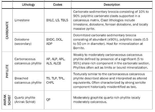
Figure 7.2: Typical Limestones and Dolostones of the Bornite Carbonate Sequence
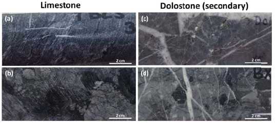
(a) Thin Bedded Limestone (TBLS): Limestone textural variant with 1mm scale banding of light and dark grey carbonaceous seams; (b) Limestone Clastic Breccia (BXLC): Carbonate sedimentary breccia with carbonate clasts in a calcareous, locally phyllitic matrix; (c) Dolostone (DOL): Partially dolomitized carbonate with late dolomite - calcite veining; (d) Dolostone Clastic Breccia (BXDC): Polylithic clasts dolostones in a dolostone matrix. Hydrothermal cement t of (low Fe) dolomite, pyrite, +/- calcite, chalcopyrite, bornite, sphalerite.
| NovaCopper Inc. | 7-29 | |
| NI 43-101 Technical Report on the Bornite Project, | ||
| Northwest Alaska |
Figure 7.3: Typical Phyllites of the Bornite Carbonate Sequence
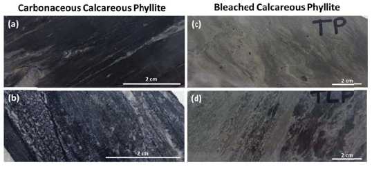
|
(a) Argillaceous/Carbonaceous Phyllite (AP): Carbonaceous, weak-mod calcareous phyllite with >75% phyllosilicates. Typically 1-2% pyrite; (b) Argillaceous/Carbonaceous Phyllitic Limestone (APL): Carbonaceous limestone (marble) with 5-20% phyllosilicates. Typically 1-2% pyrite; (c) Tan Phyllite (TP): Non-carbonaceous, weak-mod calcareous phyllite with > 75% phyllosiliicates. Typically contains 1-2% fine-grained pyrite; (d) Tan Phyllitic Limestone (TPL): Non-carbonaceous limestone (marble) with 5-20% phyllosilicates. Typically contains 1-2% very fine grainedd pyrite. | |
| 7.3.2 |
STRUCTURE |
|
Structural fabrics observed on the property include bedding and two separate foliations. Bedding (S0) can be measured only rarely where phyllite and carbonate are interbedded and it is unclear to what extent it is transposed. The pervasive foliation (S1) is easily measured in phyllites and may be reflected by colour banding and/or stylolamination (flaggy habit in outcrop) of the carbonates. Core logging shows that S1 is folded gently on the 10 m scale and locally tightly folded at the decimetre scale. S2 axial planar cleavage is locally developed in decimetre scale folds of S1. Both S1 and S2 foliations are considered to be Jurassic in age. | |
|
Owing to their greater strength, bodies of secondary dolostone have resisted strain and foliation development, whereas the surrounding limestone and calc-phyllite have become attenuated during deformation. The result is that the carbonate section increases in thickness in some areas of dolomitization and mineralization. This deformation, presumably Jurassic, complicates sedimentological interpretations. | |
|
Potentially the earliest and most prominent struucture in the resource area is the northeast-trending, steeply northwest-dipping Iron Mountain structure. The structure shows significant displacement of basal Quartz Phyllite (QP) to the east across the structure and has been interpreted as: a pre or syn-mineral (Devonian) growth fault; orr, the post-mineral (Cretaceous) axis of a small overturned kink fold. | |
|
Numerous observations can be made to support both interpretations. Importantly, the distribution of pre-mineral sedimentary breccias and the minneralization which is relatively undeformed along the corridor suggest an early ore-controlling origin of the structure while the locally overturned nature of the displacement, some possible overturned stratigraphy and mineralization and shear deformation within the Anirak Schist along its contact with the Bornite carbonate suggests a possible post-mineral fold origin. |
| NovaCopper Inc. | 7-30 | |
| NI 43-101 Technical Report on the Bornite Project, | ||
| Northwest Alaska |
|
To the north, the Bornite Carbonate sequence is in fault contact with the Beaver Creek phyllite along the moderately north-dipping Beaver Creek fault. The fault, a thick, brittle structure of potentially regional significance, defines the roughly bedded parallel base of the Beaver Creek phyllite and the Bornite Carbonate sequence in the immediate Bornite area. Both the Beaver Creek fault and the Bornite Carbonate sequence are cut by a series of north-trending high angle structures of apparent small displacement as shown in Figure 7.1 (Hitzman et al., 1982). | |
| 7.4 |
MINERAL DEPOSITS |
|
Mineralization at Bornite occurs as tabular mineralized zones that coalesce into crudely stratiform bodies hosted in secondary dolomite. Two significant dolomitic horizons that host mineralization have been mapped by drilling and include: 1) the Lower Reef, a thick 100 to 300 m thick dolomitized zone lying immediately above the basal quartz phyllite (QP) unit of the Anirak Schist; and 2) the Upper Reef, a 100 to 150 m thick dolomite horizon roughly 300 m higher in section. | |
|
The Lower Reef dolomite outcrops along the southern margin of the Ruby Creek zone and is spatially extensive throughout the deposit area. It hosts a significant portion of the shallow resources in the Ruby Creek zone as well as higher grade resources down dip and to the northeast in the South Reef. The Upper Reef zone hosts relatively high-grade resources to the north in the Ruby Creek zone. The Upper reef zone appears to lie at an important NE- trending facies transition to the NW of the main drilled area and locally appears to be at least partially thrust over the Lower Reef stratigraphy to the southeast. | |
|
Drill results from 2013 show dolomitization and copper mineralization in the Upper and Lower Reefs coalescing into a single horizon along the northern limits of current exploration. The NE- trending Ruby Creek and South Reef zones also coalesce into a roughly 1000 m wide zone of >200 m thick dolomite containing significant copper mineralization dipping north at roughly 5-10 degrees. | |
|
Figure 7.4 shows the grade thickness (Cu% x thickness in metres) distribution of copper mineralization for the Bornite deposit. |
| NovaCopper Inc. | 7-31 | |
| NI 43-101 Technical Report on the Bornite Project, | ||
| Northwest Alaska |
Figure 7.4: Copper Grade Thickness Plan Map for the Bornite Deposit (NovaCopper,2014)
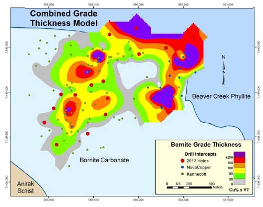
| 7.4.1 |
MINERALIZATION |
|
Copper mineralization at Bornite is comprised of chalcopyrite, bornite, and chalcocite distributed in stacked, roughly stratiform zones exploiting favourable stratigraphy within the dolomitized limestone package. Mineralization occurs, in order of increasing grade, as disseminations, irregular and discontinuous stringer-style veining, breccia matrix replacement, and stratiform massive sulphides. Figure 7.5 shows typical mineralization of the Bornite deposit characterized by chalcocite, bornite, chalcopyrite and pyrite mineralization. | |
|
The distribution of copper mineral species is zoned around the bottom-centre of each zone, with bornite-chalcocite-chalcopyrite at the core and progressing outward to chalcopyrite-pyrite. Additional volumetrically minor copper species include carrollite, digenite, tennantite-teetrahedrite, and covellite (Bernstein and Cox, 1986). Stringer pyrite and locally significant sphalerite occur above and around the copper zones, while locally massive pyrite and sparse pyrrhotite occur in association with siderite alteration below copper mineralization in the Lower Reef. | |
|
In addition to the copper mineralization, significant cobalt mineralization (for example, drill hole RC11-0187 with 34.7 m at 0.10% Co in the South Reef, and drill hole RC11- 0184 with 5.5 m at 0.44% Co in the Upper Reef) is found accompanying bornite-chalcocite mineralization. Cobalt occurs with high-grade cop pper as both carrollite (Co2CuS4) and as cobaltiferous rims on recrystallized pyrite grains (Bernstein and Cox, 1986). |
| NovaCopper Inc. | 7-32 | |
| NI 43-101 Technical Report on the Bornite Project, | ||
| Northwest Alaska |
Appreciable silver values (for example, drill hole RC11-0184 with 5.5 m at 30.9 g/t Ag) are also found with bornite-rich mineralization in the South Reef and Ruby Creek zones.
Figure 7.5: Typical Mineralization of the Bornite Deposit
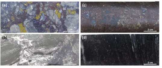
|
(a) Typical high-grade chalcocite-bornite-chalcopyrite mineralization; often form stringers, veinlettes, disseminations and breccia fillings; (b) Chalcocite (CuS) appears dark grey to black, occurs with massive sulphide zones and typically with bornite. Metaallic luster observed by tilting specimen back and forth under light; (c) Massive sulphide mineralization, chalcocite-bornite-chalcopyrite of the historically termed “No. 1 Ore Body” Upper Reef - Ruby Creek; (d) Typical disseminated 1-2% pyrite in Quartz Phyllite (QP) – Rock unit defines the base of the Bornite carbonate sequence, equivalent to the Anirak Schistt. | |
| 7.4.2 |
ALTERATION |
|
Limestone in much of the resource area is altered to secondary hydrothermal dolostone. Dolomitic alteration follows and also cuts stratigraphy, generally following the distribution of copper sulphide mineralization which is almoost entirely hoosted within it. Iron content of secondary dolomite is distinctively zoned, with high-iron dolostone centred on the axis of higher-grade chalcopyrite-bornite-chalcocite mineralization (Figure 7.6, Figure 7.7, and Figure 7.8). At its most intense, dolomitic alteration can also include secondary siderite (± pyrrhotite), which is mapped as an elongatedd northeast-trending body beneath copper mineralization in the Lower Reef (Hitzman, 1986). | |
|
Secondary dolomite alteration is mainly restricted to the limestone units, although calcareous phyllites are locally affected. More widespread are the green-gray ‘bleached’ calc-phyllites (so-called ‘talc’ phyllites), which are tentatively interpreted as an alteration product of the dark gray argillaceous calc-phyllite units. Bleached calc-phyllite occurs as discontinuous, semi-stratiform to discordant bodies within the larger interpreted phyllite beds; distribution is ambiguous with respect to dolomitization and copper mineralization. Initial analysis of ICP multi-element data indicattes that bleached phyllites have experienced neither magnesium nor sodium metasomatism. |
| NovaCopper Inc. | 7-33 | |
| NI 43-101 Technical Report on the Bornite Project, | ||
| Northwest Alaska |
Figure 7.6 and Figure 7.7 show southwest-northeast and northwest-southeast-trending schematic sections across the South Reef, showing geology, mineralization, and alteration. Figure 7.8 shows a northwest-trending schematic section through the Ruby Creek zone Upper and Lower Reefs, again showing geology, mineralization, and alteration.
Figure 7.6: SW-NE Schematic Section through the South Reef Illustrating Geology, Alteration and Sulphide Mineral Zoning
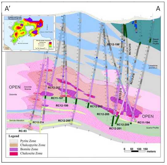
| NovaCopper Inc. | 7-34 | |
| NI 43-101 Technical Report on the Bornite Project, | ||
| Northwest Alaska |
Figure 7.7: NW-SE Schematic Section through the South Reef Illustrating Geology, Alteration and Sulphide Mineral Zoning
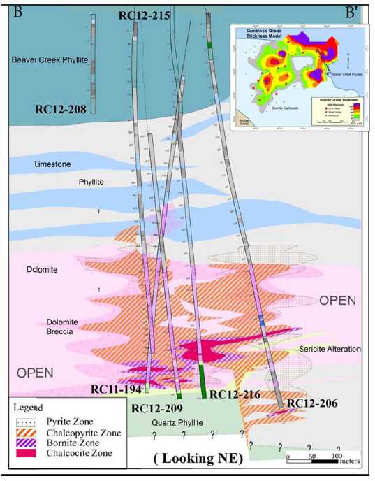
| NovaCopper Inc. | 7-35 | |
| NI 43-101 Technical Report on the Bornite Project, | ||
| Northwest Alaska |
Figure 7.8: NW-SE Schematic Section through Ruby Creek Upper and Lower Reefs Illustrating Geology, Alteration and Sulphide Mineral Zoning
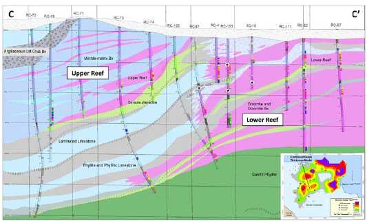
| 7.5 | PROSPECTS/EXPLORATION TARGETS |
|
The Bornite carbonate sequence, host to the miineralization at Bornite, is exposed over approximately 16 km along the north slope of the Cosmos Hills and to a lesser extent on the southern margin of the Cosmos Hills arch (Figure 7.1). Numerous areas of hydrothermal dolomitization and copper mineralization occur across the entire width of outcropping carbonatees and are the focus of ongoing regional exploration by NovaCopper. Most notable of the known prospects are the Pardner Hill and Aurora Mountain areas, where outcropping mineralization was discovered and drill-tested during the Kennecott era. | |
|
| |
|
The Pardner Hill prospect is located 5 km west of Bornite (Figure 7.1) and consists of a 3 km copper (± zinc) soil and rock geochemical anomaly in rubble cropping ferroan dolostone. Kennecott drilled 16 holes in the area and defined a stratiform copper mineralized zone approximately 150 m by 400 m and varying from 5 m to 35 m thick at the southern end of the geochemical anomaly. Mineralization remains open down-dip and to the south. | |
|
| |
|
Dolomitization and anomalous copper and zinc geochemistry also characterize the Aurora Mountain prospect located 6 km west of Bornite (Figure 7.1). Anomalies are distributed along a 2 km mineralized horizon about a third of which has been tested by four Kennecott-era drill holes. |
| NovaCopper Inc. | 7-36 | |
| NI 43-101 Technical Report on the Bornite Project, | ||
| Northwest Alaska |
| 8.0 |
DEPOSIT TYPES |
Copper-cobalt-silver-zinc mineralization at Bornite occurs as disseminations, veins, and massive sulphides forming stacked, semi-stratiform bodies closely associated with secondary hydrothermal dolomitization. The crosscutting nature of the mineralization along with the presence of early pyrite and sphalerite in sedimentary breccia clasts point to a clearly epigenetic origin, but temporally very close to the formation of the enclosing stratigraphy. Recent Re-Os dating supports this interpretation (Selby et al., 2009).
Data are limited regarding sources of the copper-rich fluids which formed the Bornite deposit, but it suggests that mineralizing fluids may have formed from the interaction of saline basinal fluids with mafic volcanic rocks mapped within the section.
Given these constraints, Bornite has characteristics similar to a series of districts and deposits including: the Mt Isa and McArthur River districts in Australia, the Tynagh deposit in Ireland, the Kipushi deposit in the Congo, and the Tsumeb deposit in Namibia. All of these deposits show: syngenetic to early epigenetic characteristics; emplacement in carbonate stratigraphy; and, early pyrite-dolomite alteration followed by sulphide mineralization.
All of these analogous deposits occur in intra-continental to continental margin settings undergoing extensional tectonics and bimodal volcanism similar to Bornite. Basin-margin faults seem to play an important role in localizing mineralization (Hitzman, 1983) even though the postulated basin margin structures at Bornite have not been directly identified.
| NovaCopper Inc. | 8-37 | |
| NI 43-101 Technical Report on the Bornite Project, | ||
| Northwest Alaska |
| 9.0 |
EXPLORATION |
| 9.1 |
INTRODUCTION |
|
Exploration work completed by previous operators BCMC and Kennecott (1957 through 1998) is summarized in Section 6.0 of the Report. In addition to extensive drilling, BCMC and Kennecott completed widespread surface geochemical sampling, regional and property scale mapping, and numerous geophysical surveys. The majorities of these data have been acquired by NovaCopper and form the bases for renewed exploration, targeting Bornite-style mineralization in the Bornite Carbonate Sequence. | |
| 9.2 |
NOVAGOLD EXPLORATION - 2006 |
|
In 2006, NovaGold contracted Fugro Airborne Surveys (Fugro) to complete a detailed helicopter DIGHEM magnetic, EM and radiometric survey of the Cosmos Hills. The survey covered a rectangular block approximately 18 km by 49 km which totaled 2,852 line kilometres. The survey was flown at 300 m line spacing with a line direction of N20E. The DIGHEM helicopter survey system produced detailed profile data of magnetics, EM responses and radiometrics (total count, uranium, thorium, and potassium) and was processed into maps of magnetics, discrete EM anomalies, EM apparent resistivity, and radiometric responses. A report and Fugro-processed maps and grids are available (Fugro, 2007). Figure 9.1 shows total field magnetics from the survey. |
| NovaCopper Inc. | 9-38 | |
| NI 43-101 Technical Report on the Bornite Project, | ||
| Northwest Alaska |
Figure 9.1: DIGHEM Total Field Magnetics(Fugro, 2007)
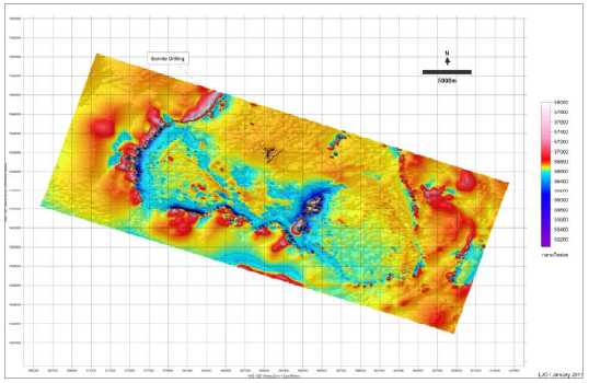
| 9.3 |
NOVAGOLD EXPLORATION - 2010 |
|
In 2010, in anticipation of completing the NANA Agreement, NANA granted NovaGold permission to begin low level exploration at Bornite; this consisted of re-logging and re- analyzing select drill holes using a Niton portable XRF. A profile containing Kennecott surface diamond drill holes: RC-27, -29, -32, -35, -53, -0, -62, and -102, and underground drill hole RU-16 were re-logged and re-analyzed in the Bornite camp in July and August 2010 (Figure 9.2). In general, the re-logging compared moderately well with the 1996 Kennecott interpretation. General relationships apparent in Figure 9.2 include: a thick area of dolomitization centered approximately at drill hole RC-60 corresponding with mineralization, and surrounding and overlying the Ruby Creek Upper Reef zone; iron-rich dolomite, forming an inner alteration zone; and, a strong stratigraphic control with mineralization occurring in dolomitized limestones immediately overlying a graphitic phyllite. |
| NovaCopper Inc. | 9-39 | |
| NI 43-101 Technical Report on the Bornite Project, | ||
| Northwest Alaska |
Figure 9.2: NW-SE Re-interpreted Profile across the Bornite Deposit - 2010
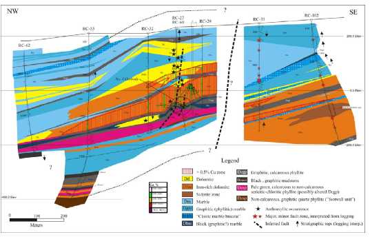
One notable distinction from the Kennecott re-logging interpretation was the recognition of a significant stratigraphic and structural discontinuity between the southeastern and northwestern parts of the section. A sharp, apparent truncation or offset of mineralization, dolomitization, and stratigraphic units across this boundary is apparent in the re-logging effort. Interpretation of the discontinuity remains unclear at this time, but it could represent either a post-mineral offset or a major facies transition or both. Interpretation of this discontinuity between the Upper and Lower reef dolomites continues to be problematic in developing a coherent structural and stratigraphic model for the deposit.
In addition to the 2010 re-logging effort, NovaGold contracted a consulting geophysicist, Lou O'Connor, to compile a unified airborne magnetic map for the Ambler mining district from Kennecott, Alaska DNR, and NovaGold airborne geophysical surveys; the compilation is shown in Figure 9.3.
| NovaCopper Inc. | 9-40 | |
| NI 43-101 Technical Report on the Bornite Project, | ||
| Northwest Alaska |
Figure 9.3: District Airborne Magnetics Compiled From Kennecott, AK DNR and NovaGold Surveys (O’ Connor, 2010)
![]()
| 9.4 | NOVAGOLD EXPLORATION - 2011 |
|
In 2011, NovaGold contracted Zonge International Inc. (Zonge) to conduct both dipole- dipole complex resistivity induced polarization (CRIP) and natural source audio- magnetotelluric (NSAMT) surveys over the northern end of the prospect to develop tools for additional exploration targeting under cover to the north. | |
|
NSAMT data were acquired along two lines totaling 5.15 line-km, with one line oriented generally north-south through the centre of the survey area and one being the southernmost east-west line in the survey area. CRIP data were acquired on five lines: four east-west lines and one north-south line, for a total coverage of 14.1 line-km and 79 collected CRIP stations. The initial objective of the survey was to investigate geological structures and the distribution of sulphides possibly associated with copper mineralization. | |
|
Results from the paired surveys show that wide-spaced dipole-dipole resistivity is the most effective technique to directly target the mineralization package. Broad low resistivity anomalies reflecting pyrite haloes and mineralization appear to define the limits of the fluid package. Well-defined and often very strong chargeability anomalies are also present, but appear in part to be masked by phyllitic units which also have strong chargeability signatures. The NSAMT show similar resistivity features as the IP, but are less well resolved. |
| NovaCopper Inc. | 9-41 | |
| NI 43-101 Technical Report on the Bornite Project, | ||
| Northwest Alaska |
| 9.5 |
NOVACOPPER EXPLORATION - 2012 |
|
In light of the success of the 2011 geophysical program, NovaCopper contracted Zonge to conduct a major district-wide dipole/dipole IP survey, a down-hole IP radial array survey in the South Reef area, and an extensive physical property characterization study of the various lithologies to better interpret the existing historical geophysical data. | |
|
Zonge completed 48 line km of 200 m dipole/dipole IP during 2012, infilling and expanding on the 2011 survey, and stretching across the most prospective part of the outcropping permissive Bornite Carbonate sequence. Figure 9.4 and Figure 9.5 show isometric views of the combined 2011 and 2012 surveys for resistivity and IP, respectively. The results show a well-defined low resistivity area associated with mineralization and variable IP signatures attributed both to mineralization and the overlying Beaver Creek phyllite. Numerous target areas occur in the immediate Bornite area with lesser targets occurring in the Aurora Mountain and Pardner Hill areas and in the far east of the survey area. During the 2012 drill program at South Reef, a single drill hole was targeted on a low resistivity area approximately 500 m to 600 m southeast of the South Reef mineralization trend. Although the drill hole intersected some dolomite alteration in the appropriate stratigraphy, no significant sulphides were encountered. | |
|
In addition to the extensive ground IP survey, Zonge also completed 9 km of down-hole radial IP using an electrode placed in drill hole RC12-0197 to further delineate the trend and potential in and around the South Reef. | |
|
In addition to the 2012 ground geophysical surveys, extensive physical property data including resistivity, chargeability, specific gravity, and magnetic susceptibility were captured for use in modelling the existing ground IP and gravity surveys, and the airborne EM and magnetic surveys. In general, some broad comments can be made concerning geophysical domains in and around mineralization at Bornite. Mineralization is characterized by low resistivity < 20 ohms, ambiguous but elevated, often irregular chargeability highs (> 35 milliradians) marginal to the mineralization, and 3-5 milligal gravity anomalies. Mineralization appears to lie along the flanks of 20-150 nT long wave magnetic anomalies which might reflect deep-seated mafic greenstones deeper in the stratigraphy. | |
|
In addition to geophysical focused exploration, a district wide geologic map was compiled integrating Kennecott’s 1970’s mapping of the Cosmos Hills with selective NovaCopper mapping in 2012. |
| NovaCopper Inc. | 9-42 | |
| NI 43-101 Technical Report on the Bornite Project, | ||
| Northwest Alaska |
Figure 9.4: Isometric View of 2011 and 2012 Resistivity Profiles
Figure 9.5: Isometric View of 2011 and 2012 Chargeability Profiles
| NovaCopper Inc. | 9-43 | |
| NI 43-101 Technical Report on the Bornite Project, | ||
| Northwest Alaska |
| 9.6 |
NOVACOPPER EXPLORATION - 2013 |
|
The emphasis of the 2013 program was to further validate and refine the 2012 geologic map of the Cosmos Hills. A deep penetrating soil and vegetation geochemical orientation survey was completed over the South Reef deposit, utilizing various partial leaches and pH methods. The initial, approximately 1 km, test lines suggest a good response for several of the partial leaches of the soils but little response in the vegetative samples; further follow-up is warranted to the north of the deposit into the Ambler lowlands. | |
| 9.7 |
EXPLORATION POTENTIAL |
|
Outcropping exposures of the mineralization-hosting carbonate stratigraphy along with large areas of precursor dolomite alteration occur over approximately 18 km of strike along the northern flank of the Cosmos Hills. Historical exploration drilling has focused solely on outcropping mineralization and subsurface extensions at the Bornite, Aurora Mountain, and Pardner Hill areas. Much of the carbonate belt has yet to be evaluated. | |
|
Recent US Geological Survey (USGS) dating of mineralization in the Ambler mining district has shown that the VMS belt that hosts the Arctic deposit and the Bornite carbonate- hosted mineralization are contemporaneous and only slightly post-date enclosing stratigraphy (Selby et al., 2009). This early and extensive syngenetic/early epigenetic signature, along with the overall fluid chemistry of the system investigated by early workers, such as Hitzman (1983 and 1986), point to large saline basin-generated fluid transport as the mechanism controlling the metallogeny of the Ambler mining district. Importantly, similar metallogenies related to saline, basin-generated fluids and their associated deposits form some of the largest copper districts in the world. | |
|
Understanding the potential scale of mineralization in the Ambler mining district has led NovaCopper to adopt geophysical and geochemical zonation as the main tools for exploration. | |
|
Airborne geophysics completed in 2006, discussed in Section 9.1, along with district-wide compilations of select third party data, discussed Section 9.2 and shown in Figure 9.3, show that the Bornite carbonate section and bounding stratigraphy simply dip to the north under the Ambler lowlands toward the Ambler Schist Belt. This opens up important potential to explore for high-grade, Bornite-style, carbonate-hosted deposits at depth using new deeper-penetrating geophysical techniques. | |
|
The geophysical surveys have delineated significant north-northeast to northeast oriented structures which appear in part to control local basin morphology and mineralization (Figure 9.1). Better understanding of basin development and its structural framework is critical to the exploration of Bornite-style systems. | |
|
In 1999, Kennecott completed an initial gravity survey of the lowlands showing significant gravimetric anomalies which may indicate structural dislocations and potential alteration and mineralization (Figure 6.1) . In 2011, NovaCopper investigated both deep IP and NSAMT geophysical techniques. |
| NovaCopper Inc. | 9-44 | |
| NI 43-101 Technical Report on the Bornite Project, | ||
| Northwest Alaska |
Results from the 2011 program led to a 2012 district-wide, 200 m dipole-dipole, deep-penetrating IP survey; the results are summarized in Section 9.4. That survey along with extensive 2012 physical property data capture for all lithologies, and existing ground IP, gravity and airborne EM and magnetic surveys is currently being used to develop a comprehensive geophysical model of the district to support future exploration targeting.
In addition to the geophysical techniques used in exploration, recent ICP trace element analysis suggests a series of effective zonation vectors, including very distinct high iron (as pyrite) and zinc (as sphalerite) zones which overly and cap areas of significant copper mineralization. Further geochemical targeting in 2013 utilizing deep penetrating methodologies employing partial leaches of soils and vegetation suggests a potent tool to continue to target mineralization under very significant cover into the Ambler lowlands.
| NovaCopper Inc. | 9-45 | |
| NI 43-101 Technical Report on the Bornite Project, | ||
| Northwest Alaska |
| 10.0 |
DRILLING |
| 10.1 | INTRODUCTION |
|
A total of 183 surface core holes and 51 underground core holes, totaling 78,147 m have been drilled, targeting the Bornite deposit during 21 different annual campaigns dating from 1957 through 2013. All of the drill campaigns, with the exception of the 2011 NovaGold campaign and the 2012 and 2013 NovaCopper campaigns were completed by Kennecott or their exploration subsidiary BCMC. Table 10.1 summarizes operators, annual campaigns, number of drill holes and metres drilled on the deposit. All drill holes listed in this table (except RC13-230 and RC13-232 which have been reserved for metallurgical studies) were utilized in the estimation of the current resource. |
| NovaCopper Inc. | 10-46 | |
| NI 43-101 Technical Report on the Bornite Project, | ||
| Northwest Alaska |
Table 10.1: Summary Bornite Drill Hole Campaigns by Operator
| Year | Surface DH's | UG DH's | Metres | Operator |
| 1957 | 8 | 1,749 | BCMC | |
| 1958 | 10 | 2,150 | Kennecott/BCMC | |
| 1959 | 14 | 4,932 | Kennecott/BCMC | |
| 1960 | 13 | 4,083 | Kennecott/BCMC | |
| 1961 | 33 | 13,590 | Kennecott/BCMC | |
| 1962 | 24 | 8,450 | Kennecott/BCMC | |
| 1963 | 1 | 396 | Kennecott/BCMC | |
| 1966 | 0 | 26 | 1,384 | Kennecott/BCMC |
| 1967 | 0 | 21 | 1,862 | Kennecott/BCMC |
| 1968 | 8 | 4 | 3,210 | Kennecott/BCMC |
| 1969 | 2 | 781 | Kennecott/BCMC | |
| 1970 | 2 | 733 | Kennecott/BCMC | |
| 1971 | 2 | 829 | Kennecott/BCMC | |
| 1972 | 2 | 712 | Kennecott/BCMC | |
| 1974 | 1 | 456 | Kennecott/BCMC | |
| 1975 | 1 | 316 | Kennecott/BCMC | |
| 1976 | 6 | 2,168 | Kennecott/BCMC | |
| 1997 | 3 | 928 | Kennecott/BCMC | |
| 2011 | 14 | 5,819 | NovaGold | |
| 2012 | 22 | 15,457 | NovaCopper | |
| 2013 | 17 | 8,142 | NovaCopper | |
| Total | 183 | 51 | 78,147 |
Sprague and Henwood, a Pennsylvania-based drilling company, completed all of the Kennecott drilling, with the exception of the 1997 program (three drill holes) completed by Tonto Drilling Services, Inc. (a NANA-Dynatech company). The 2011 thru 2013 NovaGold/NovaCopper programs used Boart Longyear Company as the drill contractor. Table 10.2 summarizes the drill campaigns, the core sizes used, and the drilling contractors.
| NovaCopper Inc. | 10-47 | |
| NI 43-101 Technical Report on the Bornite Project, | ||
| Northwest Alaska |
Table 10.2: Summary of Bornite Drill Hole Campaigns by Drill Contractor
| Year | Total DH's | Metres | Core Size | Drill Contractor |
| 1957 | 8 | 1,749 | AX | Sprague and Henwood |
| 1958 | 10 | 2,150 | AX | Sprague and Henwood |
| 1959 | 14 | 4,932 | AX & BX | Sprague and Henwood |
| 1960 | 13 | 4,083 | AX & BX | Sprague and Henwood |
| 1961 | 33 | 13,590 | AX, BX, & NX | Sprague and Henwood |
| 1962 | 24 | 8,450 | AX, BX, & NX | Sprague and Henwood |
| 1963 | 1 | 396 | BX | Sprague and Henwood |
| 1966 | 26 | 1,384 | EX & AX | Sprague and Henwood |
| 1967 | 21 | 1,862 | EX & AX | Sprague and Henwood |
| 1968 | 12 | 3,210 | BX & AX | Sprague and Henwood |
| 1969 | 2 | 781 | BX | Sprague and Henwood |
| 1970 | 2 | 733 | BX | Sprague and Henwood |
| 1971 | 2 | 829 | BX? | Sprague and Henwood |
| 1972 | 2 | 712 | BX? | Sprague and Henwood |
| 1974 | 1 | 456 | NX & BX | Sprague and Henwood |
| 1975 | 1 | 316 | NX & BX | Sprague and Henwood |
| 1976 | 6 | 2,168 | NXWL & BXWL | Sprague and Henwood |
| 1997 | 3 | 928 | NX & HQ | Tonto |
| 2011 | 14 | 5,819 | NQ & HQ | Boart Longyear |
| 2012 | 22 | 15,457 | NQ & HQ | Boart Longyear |
| 2013 | 17 | 8,142 | NQ & HQ | Boart Longyear |
| Total | 234 | 78,147 |
| NovaCopper Inc. | 10-48 | |
| NI 43-101 Technical Report on the Bornite Project, | ||
| Northwest Alaska |
Figure 10.1: Plan Map Showing Drill Holes Utilized in Resource Estimation (NovaCopper,2014)
| 10.2 | DRILL CORE PROCEDURES |
|
In the initial years of drilling at Bornite, Kennecott relied on AX core (1.1875 in or 30.2 mm diameter), but, as drilling migrated towardss deeper targets, a change to BX core (1.625 in or 41.3 mm diameter) was implemented to help limit deviation. From 1966 to 1967, drilling activity at Bornite moved underground and EX diameter core (0.845 in or 21.5 mm diameter) was implemented to define the Ruby Creek Upper Reef zone “No.1 Ore Body”. Drilling activity moved back to the surface in 1968, and, from 1968 to 1972, BX core was most commonly drilled. In later years, core size increased to NX (2.125 in or 54.0 mm diameter) and finally, in 2011, core size increased to NQ (1.874 in or 47.6 mm diameter) and HQ (2.5 in or 63.5 mm diameter). Progressively larger diameter drill rods have been continually used over the years in ann attempt to minimize drill hole deviations. | |
|
The Kennecott and NovaCopper era drilling have been conducted using drill equipment utilizing imperial measurement units. All Imperial units havee been converted to metric equivalents in the NovaCopper database for the purposes of data management. NovaCopper works exclusively in metric units. |
| NovaCopper Inc. | 10-49 | |
| NI 43-101 Technical Report on the Bornite Project, | ||
| Northwest Alaska |
| 10.2.1 | BCMC/KENNECOTT PROCEDURES |
|
There is only partial knowledge of specific drill core handling procedures used by Kennecott during their tenure at the Bornite Deposit. All of the drill data collected during the Kennecott drilling programs (1958 to 1997) was logged on paper drill logs, copies of which are stored in the Kennecott office in Salt Lake City, Utah. Electronic scanned copies of the paper logs, in PDF format, are held by NovaCopper. | |
|
Drill core was sawed or split with a splitter, with half core submitted to various assay labs and the remainder stored in the Kennecott core storage facility at the Bornite Deposit. In 1995, Kennecott entered the drill assay data, the geologic core logs, and the down hole collar survey data into an electronic format. In 2009, NovaGold geologists verified the geologic data from the original paper logs against the Kennecott electronic format and then merged the data into a Microsoft™ SQL database. | |
|
Sampling of drill core by Kennecott and BCMC focused primarily on the moderate to high grade mineralized zones. Intervals of visible sulphide mineralization containing roughly >0.5 to 1% copper were selected for analysis by Union Assay Office Inc. of Salt Lake City, Utah. This approach left numerous intervals containing weak to moderate copper mineralization un-sampled in the historic drill core. During the 2013 exploration program, NovaCopper began sampling a portion of this remaining drill core in select holes in the Ruby Creek area. NovaCopper plans to continue to collect additional samples from these older core intervals in order to provide a more extensive and continuous suite of data across the deposit area. | |
| 10.2.2 |
NOVAGOLD/NOVACOPPER PROCEDURES |
|
Throughout NovaCopper’s tenure at Bornite, the following core handling procedures have been implemented. Core is slung by helicopter, or transported by truck or ATV, from the drill rig to the core-logging facility. Upon delivery, geologists and geotechnicians open and inspect the core boxes for any irregularities. They first mark the location of each drilling block on the core box, and then convert footages on the blocks into metric equivalents. Geotechnicians or geologists measure the intervals (or “from/to”) for each box of core and include this information, together with the drill hole ID and box number, on a metal tag stapled to the end of each box. | |
|
Geotechnicians then measure the core to calculate percent recovery and rock quality designation (RQD). RQD is the sum of the total length of all pieces of core over 12 cm in a run. The total length of core in each run is measured and compared to the corresponding run length to determine percent recovery. | |
|
Core is then logged with lithology and visual alteration features captured on observed interval breaks. Mineralization data, including total sulphide (recorded as percent), sulphide type (recorded as a relative amount), and gangue and vein mineralogy are collected for each sample interval with an average interval of approximately 2 m. Structural data is collected as point data. |
| NovaCopper Inc. | 10-50 | |
| NI 43-101 Technical Report on the Bornite Project, | ||
| Northwest Alaska |
Geologists then mark sample intervals to capture each lithology or other geologically appropriate intervals. Sample intervals of core are typically between 1 m and 3 m in length but are not to exceed 3 m in length. Occasionally, if warranted by the need for better resolution of geology or mineralization, smaller sample intervals have been employed. Geologists staple sample tags on the core boxes at the start of each sample interval, and mark the core itself with a wax pencil to designate sample intervals. This sampling approach is considered sound and appropriate for this style of mineralization and alteration.
Drill core is digitally photographed prior to sampling.
Drill core is cut in half using diamond core saws. Specific attention to core orientation is maintained during core sawing to ensure that representative samples are obtained. One-half of the core is retained in the core box for storage on site, or at NovaCopper's Fairbanks warehouse, and the other half bagged and labeled for analysis. Samples are selected for specific gravity measurements as discussed in Section 11.0 of this report.
In 2013, 33 historic Kennecott drill holes in the Ruby Creek area were re-logged, re-sampled and re-assayed as these holes had previously only been selectively sampled by Kennecott. Entire holes were re-logged utilizing NovaCopper protocols discussed above. Samples were submitted either as half-core, where previously sampled, or whole core where un-sampled (this was done to ensure that a sufficient volume of material was provided for analysis). Sample intervals were matched to historic intervals whenever possible, or selected to reflect NovaCopper sampling procedures described above. The objectives of the re-assay/re-logging program were threefold: 1) to implement a QA/QC program on intervals previously sampled by Kennecott in order to confirm the validity of their results; 2) to identify additional lower-grade (0.2 -0.5% copper), which was not previously sampled; and 3) to provide additional multi-element ICP data to assist in the geologic interpretation of the deposit. A further discussion of the program and its results are incorporated in Sections 11 and 14 of this report.
| NovaCopper Inc. | 10-51 | |
| NI 43-101 Technical Report on the Bornite Project, | ||
| Northwest Alaska |
Table 10.3: BCMC/Kennecott era Drill Holes Re-logged & Re-assayed by NovaCopper
| Year Re-logged/ Re-assayed |
Area |
Drill Holes |
| 2012 | South Reef | RC-92, RC-93, RC-95, RC-96, RC-99, RC-102, RC-163, RC-168, RC-174 |
| 2013 | Ruby Creek | RC-3, RC-4, RC-19, RC-29, RC-30, RC-34, RC-35, RC- 35W, RC-37, RC-48, RC-50, RC-51, RC-54, RC-55, RC-57, RC-61, RC-64, RC-66, RC-67, RC-68, RC-73, RC-83, RC- 84, RC-86, RC-87, RC-111, RC-151, RC-152, RC-153, RC-165, RC-166, RC-169, RC-172 |
|
The 2011 thru 2013 NovaGold/NovaCopper diamond drilling programs used a commercial, computer-based core logging system for data capture; GeoSpark Logger© developed by GeoSpark Consulting Inc. During each drill program, all logging data was captured on individual laptops in a Microsoft™ SQL database and then validated and merged into the camp server. In 2012, the system was modified to allow each laptop to sync daily to the Data Logger database residing on the Bornite Camp server. The server was periodically backed up and the database was sent to Vancouver, British Columbia for integration into the master database. The camp server is stored in the Fairbanks field office at the end of each field season. Hardcopies of the 2011 thru 2013 drill core logs are stored in the Fairbanks office. Scanned copies of the Kennecott-era drill logs are also stored in the Fairbanks field office. | |
| 10.3 |
DRILL CORE RECOVERY |
|
Table 10.4 shows the core recovery data compared to various rock types with available recovery data for all campaigns through to 2013. In general, core recovery averaged >87.8% with only slightly poorer recoveries in phyllitic rocks. The dolostone and the dolostone clastic breccia, principal hosts of mineralization, show recoveries of 87.3% and 90.3 respectively. |
| NovaCopper Inc. | 10-52 | |
| NI 43-101 Technical Report on the Bornite Project, | ||
| Northwest Alaska |
Table 10.4: Core Recovery versus Lithology
| Lithology | % Recovery | Standard Deviation |
Number of Samples |
Length (m) |
| Argillaceous Carbonaceous Phyllite | 87.1 | 21.1 | 4719 | 8661 |
| Argillaceous Dolomitic Phyllite | 77.2 | 26.3 | 16 | 23 |
| Argillaceous Limestone Clastic Breccia | 92.5 | 34.8 | 2253 | 3833 |
| Dolostone & Thinly Bedded Dolostone | 87.3 | 27.0 | 5008 | 5493 |
| Dolostone Clastic Breccia | 90.3 | 24.2 | 7187 | 8255 |
| Fault Zone | 61.0 | 32.4 | 229 | 401 |
| Limestone & Thinly Bedded Limestone | 90.6 | 25.4 | 2205 | 3505 |
| Limestone Clastic Breccia | 89.9 | 21.1 | 5540 | 9541 |
| Massive Sulfides | 94.8 | 17.3 | 210 | 168 |
| Quartz Phyllite | 82.4 | 24.5 | 652 | 1305 |
| Talc Phyllite & Talc Lime Phyllite | 83.8 | 36.6 | 979 | 1272 |
| Undefined | 55.0 | 38.9 | 88 | 527 |
| Total | 87.8 | 26.2 | 29086 | 42985 |
| 10.4 | COLLAR SURVEYS |
| 10.4.1 | KENNECOTT TENURE |
|
Kennecott provided NovaGold with collar coordinates for all historical holes in UTM coordinates using the NAD27 datum. During the 2011 field season, the collar locations of 63 historic surface holes were re-surveyed in UTM NAD83 zone 4N datum. The results of this re-survey were compared to the original Kennecott collar survey data as described below. | |
|
Horizontal errors were found to cluster tightly around zero, with a mean difference of +1.61 m Easting and -0.80 m Northing. Absolute total horizontal error ranged from 0.39 m to a maximum 24.27 m, with a median absolute error of 1.22 m. The 24.27 m difference was considered to be the result of an individual surveying error. Based on these results, the remaining 68 un-surveyed Kennecott drill hole collars were accepted without application of a horizontal correction. | |
|
Vertical errors were identified in the 2011 collar re-survey campaign. The checks revealed a semi-systematic elevation error of about +10 m vertical for most of the historic collar locations compared to the 2011 re-survey. Elevation differences in the existing database were found to range from -2.17 m to +10.91 m, with a median error of +9.61 m. While these errors show some systematic patterns in space and time, a unifying correction factor for elevation based on the survey results was considered inappropriate. Ultimately, NovaCopper assigned collar elevations for all historic drill holes that could not be re-surveyed based on the 2010 PhotoSat 1 m resolution digital terrain model (DTM). The collar elevations for the 63 re-surveyed holes were assigned elevations from the 2011 re-survey. |
| NovaCopper Inc. | 10-53 | |
| NI 43-101 Technical Report on the Bornite Project, | ||
| Northwest Alaska |
|
Also, the benchmark for the shaft and the elevation control for the underground drill hole collar surveys could not be located during the re-survey exercise to provide a reasonable elevation check between the underground survey and the surface elevations of the DTM. Therefore, the underground holes were given a blanket +10 m vertical correction consistent with the error observed in the re-surveyed surface holes around the underground workings. As a quantitative check, it was confirmed that the lithological contacts constructed from the adjusted drill holes aligned well with the lithological contacts encountered in the 2011 drilling. | |
| 10.4.2 |
NOVACOPPER TENURE |
|
Collar locations for the 14 holes drilled in 2011 were surveyed by NovaGold using a differential GPS relative to benchmark ‘AAA-1' established by Karl Spohn, PLS, WH Pacific, Inc. (WHPacific), in 2010. An Ashtech ProMark2 GPS instrument was used for these surveys. | |
|
In 2012, collar locations for 17 of the 22 holes drilled in 2012 were surveyed by WHPacific professional land surveyors using a differential GPS relative to benchmark ‘AAA-1’. The remaining five holes were surveyed by NovaCopper using an Ashtech ProMark2 GPS instrument relative to benchmark ‘AAA-1’. | |
|
In 2013, collar locations for all 17 drill holes were surveyed by NovaCopper using an Ashtech ProMark2 GPS instrument relative to benchmark ‘AAA-1’. All 2011, 2012 and 2013 holes were surveyed in the UTM NAD83 zone 4N datum coordinate system. | |
| 10.5 |
DOWN-HOLE SURVEYS |
|
Approximately one half of the drill holes in the database have associated down-hole surveys. On a core-length basis, this represents approximately 71% of the drilling, as the more recent holes, which typically have down-hole surveys, tend to be longer compared to the historic drilling. | |
|
Since 1961, Sperry-Sun single shot surveys were conducted on drill holes that encountered significant mineralization. Drill holes with marginal mineralization were often not surveyed. In 1961, Kennecott attempted to conduct down-hole surveys in holes drilled in 1959 and 1960. Of the 51 underground holes, only 11 are surveyed. From 1968 through 1997, down-hole surveys were sporadic. The first six holes of the 1968 campaign, and all holes drilled in 1971 and 1997 were not surveyed. | |
|
Four Kennecott drill holes at South Reef that were never surveyed have been assigned projected deviations based on nearby (surveyed) holes (down-hole surveys have been assigned to holes RC-96, RC-95, RC-99 and RC-163). The resulting locations of mineralized intervals in these drill holes mesh better with the overall geologic interpretation of the deposit. |
| NovaCopper Inc. | 10-54 | |
| NI 43-101 Technical Report on the Bornite Project, | ||
| Northwest Alaska |
Many of the Kennecott holes in the Ruby Creek are relatively short and, therefore, deviation is not a significant issue. In the deeper drilling at South Reef, NovaCopper has appropriately used implied deviations based on local experience. It is felt that the lack of down-hole survey data in some of the Kennecott drill holes does not have a material effect on the estimation of mineral resources at Bornite.
NovaGold (in 2011) and NovaCopper (in 2012 and 2013) completed down-hole surveys of all of their drill holes using a Reflex Easy-Shot instrument. The 2011 holes were surveyed every 30 m, and the 2012 and 2013 holes were surveyed every 45 m. Figure 10.2 shows surface drill holes with down-hole survey data.
Figure 10.2: Surface Drilling with Down-Hole Surveys (NovaCopper, 2014)
| NovaCopper Inc. | 10-55 | |
| NI 43-101 Technical Report on the Bornite Project, | ||
| Northwest Alaska |
| 11.0 |
SAMPLE PREPARATION, ANALYSES, AND SECURITY |
| 11.1 |
SAMPLE PREPARATION |
|
The sampling procedures are described in Section 10 of this report. Once drill core was sawed, one half was retained for future reference and the other half was sent to ALS Minerals (formerly ALS Chemex) in Vancouver for analyses. | |
|
Shipment of core samples from the Bornite camp occurred whenever backhaul capacity was available on the chartered aircraft, which was generally 5 to 6 days a week. Rice bags, containing two to four individual poly-bagged core samples, were marked and labeled with the ALS Minerals address, project name (Bornite), drill hole number, bag number, and sample numbers enclosed. Rice bags were secured with a pre-numbered plastic security tie, assembled into loads for transport by chartered flights on a commercial airline to Fairbanks, and directly delivered by a contracted expeditor to the ALS Minerals preparation facility in Fairbanks. In addition to the core samples, control samples were inserted into the shipments at the approximate rate of one standard, one blank and one duplicate per 17 core samples: |
| • |
Standards: four to five certified standards were used each year at the Bornite Project. Standard reference material was purchased from a commercial supplier (CDN located in Vancouver BC). Standards were “blindly” incorporated into the sample sequence. When required, the core cutter inserted a sachet of the appropriate standard, as well as the sample tag, into the sample bag. | |
| • |
Blanks: were composed of un-mineralized marble drill core from an abandoned hole, which was split to mimic a regular core sample. Blanks were also incorporated “blindly” into the sample sequence. When required, the core cutter inserted about 150 g of blank, as well as the sample tag, into the sample bag. | |
| • |
Duplicates: the assay laboratory was instructed to split the sample and run both splits as two separate samples. The core cutter inserted a sample tag into an empty sample bag. |
Samples were logged into a tracking system on arrival at ALS Minerals, and weighed. Samples were then crushed, dried, and a 250 g split was pulverized to greater than 85% passing 75 μm.
| NovaCopper Inc. | 11-56 | |
| NI 43-101 Technical Report on the Bornite Project, | ||
| Northwest Alaska |
Table 11.1: Standard Reference Materials Used by Year
| 2011 | 2012 | 2013 |
| Std-ME09 | CDN-ME-09 | CDN-ME-09 |
| Std-OREAS-111 | CDN-ME-18 | CDN-ME-18 |
| Std-OREAS-75a | GBMS304-5 | OREAS-24b |
| Std-OREAS-90 | STd-OREAS-90 | OREAS-92 |
| Std-OREAS-90 |
| 11.1.1 |
DENSITY DETERMINATIONS |
|
Density determinations were not conducted by BCMC/Kennecott on any of the older drill holes. NovaCopper has conducted SG measurements on some select historic drill holes during the 2013 re-sampling program. | |
|
In total, 4,471 valid SG determinations were collected during 2011, 2012 and 2013, ranging from 2.12 to 4.94. NovaGold and NovaCopper geologists collected “full-assay- width” SG determinations from available historic split core and NovaGold/NovaCopper whole core. The samples averaged 1.02 m in length and were collected continuously within mineralized zones estimated as having ≥ 1% chalcopyrite (CuFeS2) or its equivalent copper content (0.3% Cu). In un-mineralized zones, samples were collected every 10 to 15 m. A digital Intell-Lab Balance was utilized to determine a weight-in-air value for dried core, followed by a weight-in-water value. The wet-value was determined by submerging the entire assay interval within a wire basket into a water-filled tote. The SG value was then calculated using the following formula: |
Weight in air
[Weight in air – Weight in water]
|
Samples were not sealed with wax prior to measuring the weight-in-water. There is relatively little porosity evident in the rocks at Bornite and, as a result, this is not considered to be a significant factor in determining density measurements. The density measurements appear to be appropriate for a deposit of this type. | |
| 11.2 |
SECURITY |
|
Security measures taken during historical Kennecott and BCMC programs are unknown to NovaCopper; however, NovaCopper is not aware of any reason to suspect that any of these samples have been tampered with. The 2011 to 2013 samples were either in the custody of NovaGold or NovaCopper personnel or the assay laboratories at all times, and the chain of custody of the samples is well documented. |
| NovaCopper Inc. | 11-57 | |
| NI 43-101 Technical Report on the Bornite Project, | ||
| Northwest Alaska |
| 11.3 |
ASSAYING AND ANALYTICAL PROCEDURES |
|
The laboratories used during the various exploration, infill, and step-out drill analytical programs completed on the Bornite Project are summarized in Table 11.2. | |
|
Gold assays in 2011 and 2012 were determined using fire analysis followed by an atomic absorption spectroscopy (AAS) finish; gold was not analyzed in 2013. The lower detection limit was 0.005 ppm gold; the upper limit was 10 ppm gold. An additional 48- element suite was assayed by inductively coupled plasma-mass (ICP-MS) and atomic emission spectroscopy (ICP_AES) methodologies, following a four acid digest. Over limit (>1.0%) copper and zinc analyses were completed by atomic absorption (AA), following a four acid digest. | |
|
ALS Minerals has attained International Organization for Standardization (ISO) 9001:2000 registration. In addition, the ALS Minerals laboratory in Vancouver is accredited to ISO 17025 by Standards Council of Canada for a number of specific test procedures including fire assay of gold by AA, ICP and gravimetric finish, multi-element ICP and AA assays for silver, copper, lead and zinc. NovaCopper has no relationship with any primary or check assay labs utilized. |
Table 11.2: Analytical Laboratories Used by Operators of the Bornite Project
| Laboratory Name |
Laboratory Location |
Years Used |
Accreditation | Comment |
| Unknown | Unknown | Pre-2011, specific years unknown |
Unknown | |
| ALS Analytical Lab | Fairbanks, Alaska | 2011 2012 2013 | In 2004, ALS Chemex held ISO 9002 accreditations but changed to ISO 9001 accreditations in late 2004. ISO/International Electrotechnical Commission (IEC) 17025 accreditation was obtained in 2005. | 2011, 2012 and 2013 Primary Assay Lab |
| ALS Analytical Lab | Vancouver, BC | 2011 | In 2004, ALS Chemex held ISO 9002 accreditations but changed to ISO 9001 accreditations in late 2004. ISO/International Electrotechnical Commission (IEC) 17025 accreditation was obtained in 2005. | 2011 Secondary Check Sample Lab |
| Acme Analytical Laboratories Ltd. (AcmeLabs) | Vancouver, BC | 2012 2013 | Since inception in 1971, AcmeLabs® has been recognized as one of the leading geochemical and assaying laboratories to geologists and stock exchanges world-wide. Hold ISO 9001 and ISO/IEC 17025:2005 accreditations | 2012 and 2013 Secondary Check Sample Lab |
| NovaCopper Inc.- | 11-58 | |
| NI 43-101 Technical Report on the Bornite Project, | ||
| Northwest Alaska |
| 11.4 |
QUALITY ASSURANCE/QUALITY CONTROL |
| 11.4.1 |
CORE DRILLING SAMPLING QA/QC |
|
Previous data verification campaigns are described in the “Technical Report for the Bornite Deposit, South Reef and Ruby Creek Zones, Northwest Alaska, USA” (NovaCopper, 2013). | |
|
During 2012 and 2013, NovaCopper staff performed continuous validation of the drill data; both while logging was in progress and after the drill season was complete (West, 2013). NovaCopper also retained independent consultant Caroline Vallat, P.Geo. of GeoSpark Consulting Inc. (GeoSpark) to: 1) import digital drill data to the master database and conduct QA/QC checks upon import, 2) conduct a QA/QC review of paired historical assays and NovaCopper 2012 and 2013 re-assays; 3) monitor an independent check assay program for the 2012 and 2013 drill campaigns; and 4) generate a QA/QC report for the 2012 and 2013 drill campaigns. Below is a summary of the results and conclusions of the GeoSpark QA/QC review. | |
|
NOVACOPPER QA/QC REVIEW ON HISTORICAL ANALYTICAL RESULTS | |
|
During 2012 and 2013, NovaCopper conducted a large re-assay program and check sampling campaign on pre-NovaCopper (pre-2011) drill core. Within the Ruby Creek zone the database includes a total of 4,187 original, historic RC prefixed drill hole assays. The 2012 and 2013 exploration programs on the Bornite project included re-assay of 1,304 of these samples and the original samples are now superseded by the newer results which were analyzed by ALS. Of the 1,304 re-assays there were 865 with a match of hole identity and drill hole interval allowing direct comparison of the results. In addition to the re-assay of existing sample intervals a large number of additional samples were assayed in 2012 and 2013 for the RC prefixed drill holes amounting to 7,022 additional samples for a total of 14,822.21 m of new (2012 and 2013) sampling on the RC drill holes. Within the Bornite project database there are a total of 10,770 primary samples for RC prefixed drill holes including: |
| • |
2,377 primary samples analyzed at ALS in 2012, including 322 samples that now supersede original historic samples. | |
|
| ||
| • |
5,510 primary samples analyzed at ALS in 2013, including 543 samples that now supersede original historic samples. | |
|
| ||
| • |
2,883 primary samples that are historic in nature. |
Therefore, 73.3 percent of the assays related to the RC prefixed holes are current (2012 and 2013) and have been closely monitored for quality throughout the 2012 and 2013 exploration programs.
This detailed review of the 2012 and 2013 re-assay analytical results compared to the original historic analytical results for copper has provided insight into the reliability and potential bias within the original, historic results. Looking at the basic statistics of the data populations, the historic copper grades averaged higher, but the level of difference was quite small and at a level that GeoSpark considers insignificant overall. The copper percentile ranges for the historic grades match well with the copper percentile ranges for the 2013 re-assay results showing strong similarity within the data populations.
| NovaCopper Inc. | 11-59 | |
| NI 43-101 Technical Report on the Bornite Project, | ||
| Northwest Alaska |
|
It is GeoSpark’s opinion that this review has shown no major reason for concern with the overall quality of earlier copper estimations. | |
|
QA/QC REVIEW ON NOVACOPPER (2011 TO 2013) ANALYTICAL RESULTS | |
|
GeoSpark has conducted a series of QA/QC reviews on the NovaGold and NovaCopper Bornite Project 2011, 2012 and 2013 analytical results. These QA/QC reviews serve to infer the accuracy and precision of the analytical assay results through examination of duplicate, standard, and blank control samples. | |
|
The QA/QC reviews are documented in a series of memos (Vallat 2012, 2013a, 2013b). The reviews are summarized in the following subsections by year of campaign. | |
|
2011 | |
|
The 2011 exploration program QAQC was monitored by NovaGold. GeoSpark saw no indication of significant assay quality deficiency. | |
|
2012 | |
|
The 2012 exploration program at the Bornite Project included the drilling of 20 new drill holes (RC12-0195 to RC12-0215w) and a re-sampling and re-assaying program on 9 historic drill holes. The 2012 sampling amounted to 6,764 samples covering 14,818.63 m. | |
|
The review of the control sample analytical results indicates assay results of sufficient quality to adequately represent the drill hole results for the Bornite Project. | |
|
2013 | |
|
The 2013 exploration program at the Bornite Project included the drilling of 17 new drill holes (RC13-0217 to RC13-0233) and a large re-sampling and re-assaying program on 33 historic drill holes (31 prefixed RC and 2 prefixed NANA). The 2013 sampling amounted to 9,045 samples covering 18,656.71 m. | |
|
The review of the control sample analytical results indicates assay results of sufficient quality to adequately represent the drill hole results for the Bornite Project. | |
| 11.4.2 |
DENSITY DETERMINATIONS QA/QC |
|
QA/QC review of the 2011, 2012 and 2013 SG determinations for the Bornite Project were conducted by NovaCopper staff and are documented in a series of memos. Where SG determinations have matching assay from/to intervals, a stoichiometric check was completed (West, 2014). The 2011 and 2012 wet/dry measurements compare well with the stoichiometrically estimated values. In addition, extreme SG determinations (below 2.0 and above 5.0) were flagged and evaluated individually by the project geologist. |
| NovaCopper Inc. | 11-60 | |
| NI 43-101 Technical Report on the Bornite Project, | ||
| Northwest Alaska |
| 11.5 |
AUTHOR’S OPINION |
|
| |
|
BDRC and SGI believe the database meets or exceeds industry standards of data quality and integrity. They further believe the sample preparation, security, and analytical procedures are adequate to support resource estimation. |
| NovaCopper Inc. | 11-61 | |
| NI 43-101 Technical Report on the Bornite Project, | ||
| Northwest Alaska |
| 12.0 |
DATA VERIFICATION |
| 12.1 |
VERIFICATIONS BY BD RESOURCE CONSULTING, INC. AND SIM GEOLOGICAL INC. (2011-2013) |
|
Bruce Davis, FAusIMM, BD Resource Consulting, Inc., examined a series of randomly selected drill core intervals from the Ruby Creek and South Reef zones during his site visits in July, 2011 and September, 2012. In all cases, the type and content of observed copper-bearing minerals supported the copper grades found in the Bornite Project database. | |
|
Following the generation of the South Reef resource model in 2012, Robert Sim, P.Geo., SIM Geological Inc., randomly selected four NovaCopper-era drill holes for manual validation. The collar, survey, and assay information for these holes in the electronic database was checked against original data sources and no significant errors or differences were found. | |
|
Following the completion of the 2013 resource model, an additional 5 holes drilled by NovaCopper during the recent program, were randomly selected for validation purposes. Once again, no significant errors or differences were found. | |
| 12.2 |
CONCLUSIONS |
|
Bruce Davis and Robert Sim have reviewed NovaCopper’s drilling and sampling procedures and confirm that they follow accepted industry standards. The accuracy and precision of all NovaCopper samples have been maintained through the application of a QA/QC program that follows accepted industry standards. NovaCopper has conducted a series of validation checks that exhibit a reasonable degree of confidence in the location and assay results from the older Kennecott drill holes. | |
|
Given the assay check results, the review of the drilling and core sampling, and the comparison of certificates to the electronic database, the sample assay data are within acceptable limits of precision and accuracy to generate a mineral resource estimate. | |
|
BDRC and SGI believe the database has been generated using accepted industry standards and the contained data are sufficient for the estimation of Indicated and Inferred mineral resources. |
| NovaCopper Inc. | 12-62 | |
| NI 43-101 Technical Report on the Bornite Project, | ||
| Northwest Alaska |
| 13.0 |
MINERAL PROCESSING AND METALLURGICAL TESTING |
| 13.1 |
METALLURGICAL TEST WORK REVIEW |
| 13.1.1 |
INTRODUCTION |
|
Metallurgical studies were conducted in 1961 and 2012 with metallurgical test work campaigns undertaken at the Kennecott Research Centre (KRC), and at ALS Metallurgy (Kamloops). | |
| 13.1.2 |
HISTORICAL TEST WORK REVIEW |
|
In 1961, Kennecott collected 32 coarse reject samples from five drill holes (RC-34, RC- 54, RC-60, RC-61, and RC-65) to support preliminary metallurgical test work at Bornite. Samples targeted high-grade (> 10%) copper mineralization from the Upper Reef Ruby Creek zone (“No.1 Ore Body”) (BCMC, 1961). | |
|
All sample intervals, in total weighing approximately 68 kg (150 lbs), were composited using weighted compositing methodology. Prior to compositing, each sample was crushed and screened to pass a 10-mesh screen. The composite sample assayed 13.9% Cu. | |
|
Locked-cycle laboratory test work suggested that 97.64% of the copper was recoverable in a concentrate assaying 43.90% copper. Fine grinding to 5% passing +200-mesh was required to obtain the liberation of copper minerals from pyrite necessary for such a high recovery. Mineralogical test work on the composite sample showed high-grade mineralization of the “No.1 Ore Body” is dominated by bornite with subordinate chalcocite and chalcopyrite. | |
|
It is not known whether the test work conducted by Kennecott used samples representative of the various types of high-grade mineralization, or whether any deleterious elements were encountered during the tests. | |
| 13.1.3 |
MINERALOGICAL AND METALLURGICAL TESTWORK - NOVACOPPER |
|
INTRODUCTION | |
|
In 2012, NovaCopper contracted ALS Metallurgy of Kamloops, BC to conduct preliminary sample characterization and flotation test work on samples produced from South Reef zone mineralization of the Bornite Deposit. To the extent known, the samples are representative of the styles and types of South Reef zone mineralization and do not represent proposed open pit recoverable resources at the Ruby Creek zone. The test work program at ALS Metallurgy was based on traditional grinding and flotation test work aimed at producing saleable copper concentrates. Copper recovery test work was conducted using an assumed process flowsheet. |
| NovaCopper Inc. | 13-63 | |
| NI 43-101 Technical Report on the Bornite Project, | ||
| Northwest Alaska |
A detailed report was prepared by ALS Metallurgy entitled; “Metallurgical Assessment of the Bornite Deposit” dated June 30, 2013. The results of this report are summarized as follows.
TEST SAMPLES
The 2012 test program used 71 individual drill core sample intervals totaling 262 kg from the Bornite Deposit. Individual samples were combined into four composites, which were prepared to represent a range of copper grades (0.5 – 1.0 % Cu, 1.0 – 2.0 % Cu, 2.0 – 10.0 % Cu, and > 10.0 % Cu). The samples were obtained from drill holes completed in 2012 in the South Reef zone and typically represent high grade materials located between 400 and 600 m below surface. The chemical composition of the grade composites are summarized in Table 13.1.
Table 13.1: Summary of Chemical Analysis of Metallurgical Composites
| Sample | Cu % |
CuOx % |
CuCN % |
Fe % |
S % |
Zn % |
Au g/t |
Ag g/t |
| Composite 0.5 – 1.0 |
0.65 | 0.04 | 0.08 | 4.9 | 2.04 | 0.02 | 0.01 | <1.0 |
| Composite 1.0 – 2.0 |
1.21 | 0.07 | 0.31 | 4.9 | 3.29 | 0.01 | 0.01 | 1.0 |
| Composite 2.0 – 10.0 |
4.04 | 0.28 | 2.21 | 11.6 | 13.9 | 0.70 | 0.12 | 1.0 |
| Composite > 10.0 |
17.3 | 0.41 | 6.60 | 14.6 | 18.1 | 0.71 | 0.24 | 13.0 |
In 2013, NovaCopper drilled two holes (RC13-232 and RC13-234) specifically to collect materials for metallurgical test work in the Ruby Creek zone. These samples are currently held in frozen storage pending initial metallurgical test work for that zone.
SAMPLE HARDNESS TEST RESULTS
The four composite samples were subject to a Bond Ball Mill Work Index determination and the results are summarized in Table 13.2. Based on these results, the Bornite materials can be considered to be soft or easily ground in traditional grinding mills. The classification size used in the test work was 150 microns.
| NovaCopper Inc. | 13-64 | |
| NI 43-101 Technical Report on the Bornite Project, | ||
| Northwest Alaska |
Table 13.2: Summary of Bond Ball Mill Work Index Determinations
| Sample | Bond Ball Mill Work Index
kWhr/tonne |
| Composite 0.5 – 1.0 | 10.9 |
| Composite 1.0 – 2.0 | 8.5 |
| Composite 2.0 – 10.0 | 9.7 |
| Composite > 10.0 | 9.9 |
MINERALOGICAL INVESTIGATION
ALS Metallurgy (Kamloops) completed mineralogical studies on each of the four metallurgical composites to determine targets for grinding and liberation requirements prior to the start of flotation test work. In summary, the Bornite materials require grinding to approximately 100 microns to achieve liberation targets supporting a rough flotation stage.
Re-grinding of rougher flotation concentrates requires fine grinding in the range of 10 to 20 microns in order to achieve liberation targets for final concentrate production.
A typical photomicrograph of the 1.0 - 2.0 % composite is shown below in Figure 13.1. Shown within the photomicrograph are typical liberated copper minerals as well as somewhat complex chalcopyrite/pyrite/bornite multiphase particles.
It should be noted that higher grade materials contain significant concentrations of bornite, chalcocite and covellite which may lead to the production of higher than average copper concentrates when the flotation process is finally optimized.
| NovaCopper Inc. | 13-65 | |
| NI 43-101 Technical Report on the Bornite Project, | ||
| Northwest Alaska |
Figure 13.1: Typical Grain Size Distribution Observed at the Bornite Deposit

FLOTATIONTEST RESULTS
ALS Metallurgy (Kamloops) provided a detailed test report outlining the results of flotation tests. All four composites responded well to the recovery of copper minerals using the flow sheet shown in Figure 13.2. The proposed process is expected to incorporate the following key unit operations, which are industry standard:
| 1) |
Primary crushing | |
| 2) |
SAG milling and ball milling to approximately 100 microns | |
| 3) |
Rougher flotation | |
| 4) |
Rough concentrate re-grinding to approximately 10 to 20 microns | |
| 5) |
Flotation cleaning to produce final copper concentrates | |
| 6) |
Concentrate de-watering | |
| 7) |
Tailings deposition of tailings solids |
| NovaCopper Inc. | 13-66 | |
| NI 43-101 Technical Report on the Bornite Project, | ||
| Northwest Alaska |
Figure 13.2: Bornite Flotation Flowsheet
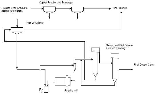
The recovery of copper and related copper concentrate grades observed in the ALS Metallurgy test work are summarized in Table 13.3.
Table 13.3: Summary of Process Simulation Test Work Results
| Sample | Feed Grade % Cu |
Copper Recovery % |
Final Conc. Grade % Cu |
| Composite 0.5 – 1.0 | 0.65 | 67.5 | 30.9 |
| Composite 1.0 – 2.0 | 1.21 | 78.0 | 29.4 |
| Composite 2.0 – 10.0 | 4.04 | 85.2 | 24.5 |
| Composite > 10.0 | 17.3 | 98.0* | 30.0* |
*open circuit test result only due to high grade feed sample
The flotation test results are not considered to be optimized due to the limited test work which was conducted in the test work program at ALS Metallurgy (Kamloops). A significant portion of the copper losses, which were observed in the test work program, were related to losses in the cleaner tailings and it is expected that these losses will be substantially reduced with additional test work. It is recommended that a copper recovery of 87 percent be used in preliminary economic analysis or resource modeling, until such time as optimization of the flotation process is complete.
Flotation parameters used in the test work are considered typical of a copper operation and included copper flotation collectors such as xanthates, and aerophine copper collectors. Lime was used for pH control in the flotation process.
| NovaCopper Inc. | 13-67 | |
| NI 43-101 Technical Report on the Bornite Project, | ||
| Northwest Alaska |
CONCENTRATE QUALITY TARGETS
The four composites were each used to generate separate saleable copper concentrates during the course of flotation test work. Detailed analysis of the final concentrates was completed and the results are summarized in Table 13.4.
Table 13.4: Summary of Concentrate Analysis– Final Copper Concentrate Results
| Element | Symbol | Unit | 0.5 - 1 Percent Test 49 Cu Con V |
1-2
Percent Test 50 Cu Con IV & V |
2-10 Percent Test 51 Cu Con IV & V |
>10 Percent Test 45 Cu Con |
| Aluminum | Al | % | 0.084 | 0.074 | 0.059 | 0.24 |
| Antimony | Sb | g/t | 330 | 32 | 96 | 44 |
| Arsenic | As | % | 0.036 | 0.019 | 0.044 | 0.12 |
| Bismuth | Bi | g/t | <20 | <20 | <20 | <20 |
| Cadmium | Cd | g/t | 24 | 11 | 145 | 45 |
| Calcium | Ca | % | 1.41 | 2.02 | 1.66 | 2.26 |
| Carbon | C | % | 1.14 | 1.59 | 0.95 | 1.28 |
| Cobalt | Co | g/t | 290 | 340 | 2240 | 4460 |
| Copper | Cu | % | 30.1 | 29.4 | 24.5 | 31 |
| Fluorine | F | g/t | 90 | 80 | 70 | 150 |
| Gold | Au | g/t | 0.2 | 0.14 | 0.27 | 0.42 |
| Iron | Fe | % | 29.6 | 27.3 | 27 | 23.5 |
| Lead | Pb | g/t | 32 | 486 | 1903 | 92 |
| Magnesium | Mg | % | 0.51 | 0.79 | 0.65 | 0.96 |
| Manganese | Mn | % | 0.02 | 0.028 | 0.027 | 0.037 |
| Mercury | Hg | g/t | 5 | 3 | 48 | 41 |
| Molybdenum | Mo | % | 0.001 | 0.001 | 0.019 | 0.012 |
| Nickel | Ni | g/t | 76 | 74 | 312 | 1118 |
| Palladium | Pd | g/t | 0.12 | 0.08 | 0.05 | 0.07 |
| Phosphorus | P | g/t | 118 | 111 | 79 | 98 |
| Platinum | Pt | g/t | 0.11 | 0.07 | 0.06 | 0.06 |
| Selenium | Se | g/t | <20 | <20 | <20 | <20 |
| Silicon | Si | % | 0.18 | 0.18 | 0.13 | 0.45 |
| Silver | Ag | g/t | 10 | 10 | 5 | 25 |
| Sulphur | S | % | 35.1 | 34.2 | 37.1 | 31.7 |
| Zinc | Zn | % | 0.29 | 0.09 | 4.1 | 1.27 |
| NovaCopper Inc. | 13-68 | |
| NI 43-101 Technical Report on the Bornite Project, | ||
| Northwest Alaska |
|
The concentrates are unlikely to contain payable precious metals as these appear to be below accepted splitting limits within traditional concentrate sales terms. | |
|
The concentrates are also considered to contain low levels of penalty elements and elements such as arsenic, antimony, mercury and cadmium. The concentrates will likely not incur any financial penalty under traditional sales terms. Zinc may incur a payable penalty if levels are consistently above about 3 percent zinc. It would be an added transportation expense at those levels as well. Zinc is typically not payable within copper concentrates. | |
| 13.2 |
RECOMMENDED TEST WORK |
|
Additional metallurgical test work is required to support the Bornite project as it moves through the development process. Key areas that require additional test work are: |
| 1. |
Additional sample material is needed to better understand the potential variability (both grade and spatial variability) that may be present in the deposit. | |
| 2. |
A thorough examination of the process parameters needed to optimize the cleaning circuit recoveries is recommended. This should address previously observed low cleaner circuit recoveries. | |
| 3. |
Additional grinding test work is required to confirm the continuity of the observed grindability data. | |
| 4. |
Concentrate quality should continue to be monitored in any future test work. |
| NovaCopper Inc. | 13-69 | |
| NI 43-101 Technical Report on the Bornite Project, | ||
| Northwest Alaska |
| 14.0 |
MINERAL RESOURCE ESTIMATE |
| 14.1 |
INTRODUCTION |
|
This section describes the generation of an updated mineral resource estimate for the Bornite Project. The mineral resource estimate has been prepared by Bruce M. Davis, FAusIMM, BD Resource Consulting (BDRC) and Robert Sim, P.Geo., SIM Geological Inc. (SGI), both “Independent Qualified Persons” as defined in NI 43-101. NovaCopper has filed two previous NI 43-101 Technical Reports on the Bornite Project dated July 18, 2012 and February 5, 2013. The effective date of this estimate is March 18, 2014. | |
|
This section describes the resource estimation methodology and summarizes the key assumptions considered by the Qualified Persons. In the opinion of the Qualified Persons, the resource evaluation reported herein is a sound representation of the copper mineral resources found on the Bornite Project at the current level of sampling. The mineral resources have been estimated in conformity with generally accepted CIM Estimation of Mineral Resources and Mineral Reserves Best Practices Guidelines and are reported in accordance with the Canadian Securities Administrators’ NI 43-101. Mineral resources are not mineral reserves and do not have demonstrated economic viability. There is no certainty that all or any part of the mineral resource will be converted into mineral reserve. | |
|
The database used to estimate the Bornite Project mineral resource was audited by the Qualified Persons. The Qualified Persons are of the opinion that the current drilling information is sufficiently reliable to interpret with confidence the boundaries for copper mineralization and that the assay data are sufficiently reliable to support mineral resource estimation. | |
|
The resource estimate was generated using MineSight® v8.20. Some non-commercial software, including the Geostatistical Library (GSLib) family of software, was used for geostatistical analyses. | |
| 14.2 |
SAMPLE DATABASE AND OTHER AVAILABLE DATA |
|
NovaCopper provided the Bornite database in Microsoft™ Excel format, exported from the master (GeoSpark Core Database System) database. The files contain collar, survey, assay, lithology, and specific gravity data, and other geological and geotechnical information. | |
|
The number and length of drill holes described here represents the database used to generate the estimate of mineral resources. These figures may differ slightly from those described in Section 10 of this report. The Project database comprises a total of 235 diamond drill (core) holes totalling 77,727 m; 174 holes target the Ruby Creek zone and 42 holes target the South Reef zone. The remaining 19 holes in the database are exploratory in nature and test for satellite mineralization proximal to the Bornite Deposit. The database contains a total of 24,538 samples that have been analyzed for copper content. Most holes drilled by NovaCopper, plus a few select holes drilled by Kennecott, contain additional analyses for elements such as zinc, lead, gold, silver, and cobalt; these do not show any significant economic potential and have been excluded from the estimation of mineral resources. |
| NovaCopper Inc. | 14-70 | |
| NI 43-101 Technical Report on the Bornite Project, | ||
| Northwest Alaska |
During the 2013 exploration program, NovaCopper collected 4,967 samples from drill hole intervals in the Ruby Creek area that were never originally tested by Kennecott. It is assumed that Kennecott never tested these intervals because, visually, they did not exhibit the presence of high-grade copper mineralization (amenable to underground mining). In previous resource estimates, these un-sampled intervals were assigned a default grade of 0% Cu. The addition of these samples greatly enhances the resource estimates in the Ruby Creek area.
Approximately 60 percent of the total core length of Kennecott era drill holes in the Ruby Creek zone remain un-sampled and are assigned default grades of 0% Cu in the current estimation. NovaCopper plans to continue to collect samples from these older drill holes. It is likely that the additional assaying of un-sampled Kennecott era intervals could incrementally enhance the resource estimate.
Individual sample intervals range from 0.15 m to 18.48 m in length and average 2.13 m. Average sample lengths at Ruby Creek are 2.08 m and at South Reef are 2.20 m.
Drill hole spacing at Ruby Creek varies from approximately 10 to 20 m in underground holes and 50 to 75 m in holes drilled from surface. All holes testing the South Reef zone are collared from surface and typically intersect mineralization at approximately 100 to 200 m spacing.
Specific gravity (SG) measurements have been conducted on 4,471 samples in the database and range from a minimum of 2.12 t/m3 to a maximum of 4.94 t/m3 and average 2.91 t/m3. The distribution of SG data is considered sufficient to support block model estimation.
Drill core recovery has been recorded for approximately one half of the holes at Ruby Creek and in essentially all of the South Reef drill holes. Overall, core recoveries are considered to be very good with an average of 88% for the Project; only 8% of samples have recoveries ≤ 50% and approximately 84% of samples have core recoveries ≥ 75%. There is no apparent correlation between copper grade and drill core recovery. There have been no adjustments or omissions to the resource database in response to drill core recoveries.
NovaCopper provided a topographic digital terrain surface derived from a 2010 Photosat 1 m resolution model. Drill hole collar locations, surveyed using a differential GPS, correlate very well with the local digital terrain (topographic) surface.
| NovaCopper Inc. | 14-71 | |
| NI 43-101 Technical Report on the Bornite Project, | ||
| Northwest Alaska |
The distribution of copper grades in drill holes is shown in Figure 14.1. The distribution of drilling by vintage including the re-sampling done in 2013 is shown in Figure 14.2 and is summarized in Table 14.1.
Figure 14.1: Copper Grades in Drill Holes
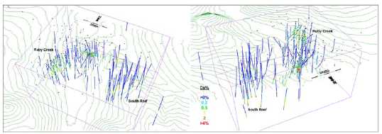
Figure 14.2: Vintage of Drilling and Sampling
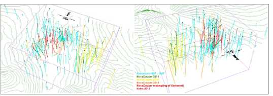
Table 14.1:Summary of Drilling Data for the Bornite Project
| Company | Years | Number of Drill Holes |
Number of Samples |
Total Sample Length (m) |
| Kennecott | 1957 - 1997 | 182 | 7,546 | 15,969 |
| NovaCopper | 2011 | 14 | 2,328 | 5,497 |
| NovaCopper | 2012 | 22 | 6,698 | 14,464 |
| NovaCopper | 2013 | 15 | 3,109 | 6,701 |
| NovaCopper | 2013 | 31* | 4,803 | 9,702 |
* 31 Kennecott holes re-sampled in 2013 in the Bornite resource area
| NovaCopper Inc. | 14-72 | |
| NI 43-101 Technical Report on the Bornite Project, | ||
| Northwest Alaska |
|
Historic drilling at the Bornite Project was conducted by Kennecott, a leading technical exploration company during its tenure, known for rigorously controlled drilling programs which typically included the insertion of quality control samples. Unfortunately, records from the Kennecott-era are incomplete and direct validation of some portions of the database cannot be made. Comparison of declustered data sets, derived from the two vintages of drilling, indicate the Kennecott and NovaCopper drilling produce essentially the same results. NovaCopper has re-sampled portions of holes drilled by Kennecott for validation purposes as described in Section 11 of this report. There is no reason to believe the sample results produced during historic drilling are significantly different from those being generated by NovaCopper. | |
|
With the drilling completed by NovaCopper, plus the additional re-sampling of the historic drill core, the original Kennecott sample data represents a relatively minor proportion of the overall database. All of the historic drilling has been included in the Bornite mineral resource estimate and there have been no adjustments made to any of this historical data. | |
| 14.2.1 |
GEOLOGIC MODEL |
|
The geologic model interpreted for the Bornite Deposit consists primarily of a series of inter-bedded carbonate and phyllitic rocks that dip gently to the north and overlay a quartz-phyllite footwall. Copper mineralization primarily occurs as massive, semi- massive, stringer, veinlet and disseminated accumulations of chalcopyrite, bornite and chalcocite in dolomitized portions of the sedimentary host rocks. The foundation of the resource model is based on a lithology model consisting of four separate carbonate units intercalated by six phyllite domains (Figure 14.3). Only two of the phyllite units occur across the extents of the resource model (Phyl6 and Phyl8). The other four phyllite domains occur only in the Ruby Creek area. The lowest Carb1 unit contains the South Reef zone and portions of the Lower Reef mineralization at Ruby Creek; the remainder of the Lower Reef zone occurs in Carb2. Phyl7 forms the boundary between Carb2 and Carb3 and segregates the Upper and Lower Reefs at Ruby Creek. |
| NovaCopper Inc. | 14-73 | |
| NI 43-101 Technical Report on the Bornite Project, | ||
| Northwest Alaska |
Figure 14.3: Schematic Section Looking North of Lithology Model Domains

Figure 14.4: Cross section through Ruby Creekarea
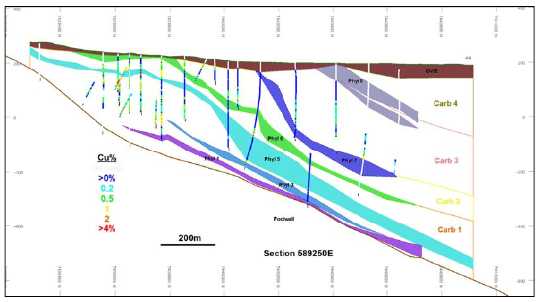
| NovaCopper Inc. | 14-74 | |
| NI 43-101 Technical Report on the Bornite Project, | ||
| Northwest Alaska |
Figure 14.5: Cross section through the South Reef area
The highest grade parts of the deposit occur within areas where semi-massive and massive sulphides are present. The density of drilling is insufficient in most areas to allow for the interpretation of these massive sullphide domains and a probability shell approach is used to identify areas where higher r-grade mineralization is likely to occur.
In order to replicate the stratiform nature of the mineralization in the resource model, a dynamic anisotropy approach relative to the overall trend of copper mineralization has been applied. Two three-dimensional planes are interpreted that represent the general trend of the copper mineralization in the upper and lower parts of the deposit as shown in Figure 14.6. These “trend planes” are used to control sea arch orientations during subsequent interpolations in the model. Variograms are gen nerated using distances relative to the trend planes rather than the true sample elevations. This approach essentially flattens out the zone during interpolation relative to the defined trend plane. The lower trend plane is used to control estimations in the Carb 1 and 2 and Phyl 1 through 6. The upper trend plane is used to control estimations in Carb 3 and 4 and Phyl 7 and 8.
| NovaCopper Inc. | 14-75 | |
| NI 43-101 Technical Report on the Bornite Project, | ||
| Northwest Alaska |
Figure 14.6: Trend Planes used to control Dynamic Isotropy during block interpolations
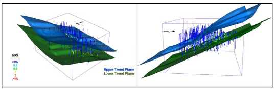
Two probability shells have been generated; one at a threshold of 2% copper and another at a threshold of 0.2% copper. The higher-grade shell occurs mainly in the South Reef area and is based primarily on visual observations of the distribution of sample data that suggest that a relatively continuous zone of higher-grade copper mineralization occurs above a threshold grade of 2% copper. Note that approximately 90 percent of the sample data in the South Reef area is below 2% Cu and 10 percent of the data is greater than 2% Cu. A relatively small >2%Cu probability shell is also generated in the Upper Reef area of Ruby Creek.
Approximately one half of the samples in the carbonate domains have copper grades above lower-grade threshold of 0.2% copper. This limit roughly segregates areas of “mineralized” verses “un-mineralized” rocks and is still below the anticipated cut-off grade of the resource, ensuring that sufficient internal dilution is retained in the resource model.
Indicator values are assigned to 2m composites at the grade thresholds described above and indicator variograms are produced. Probability estimates are made in model blocks using ordinary kriging with the vertical range and locations controlled dynamically using elevations relative to the trend planes described previously. A series of shells are generated at varying probability thresholds and compared to the distribution of the underlying sample data. The higher-grade shell represents areas where there is greater than a 30 percent chance that the grade will be e above 2% Cu. The lower-grade shell envelopes areas where there is a greater than 50 percent probability that the grade will exceed 0.2% Cu. The shape and location of the probability shells are shown in Figure 14.7.
| NovaCopper Inc. | 14-76 | |
| NI 43-101 Technical Report on the Bornite Project, | ||
| Northwest Alaska |
Figure 14.7: Copper Probability Shells

| 14.2.2 |
SUMMARY OF GEOLOGIC DOMAINS |
|
The interpreted geologic domains are summarized in Table 14.2. |
Table 14.2: Summary of Lithology and Probability Shell Domains
| Domain | Comments |
| Carb 1 | Lowest Carbonate unit. Hosts South Reef deposit and part of Lower Reef at Ruby Creek |
| Carb 2 | Upper part of Lower Reef. |
| Carb 3 | Hosts Upper Reef at Ruby Creek. |
| Carb 4 | Top carbonate unit. No significant contained copper mineralization. |
| Phyl 1 | Lower phyllite unit. |
| Phyl 3 | Interpreted in Ruby Creek area only. |
| Phyl 5 | Interpreted in Ruby Creek area only. |
| Phyl 6 | Continuous unit extending from Ruby
Creek to South Reef areas. Separates Carb 1 and Carb2 domains. |
| Phyl 7 | Phyllite unit between Upper and
Lower Reef zones at Ruby Creek. Separates Carb 2 and Carb 3 domains. |
| Phyl 8 | Upper phyllite domain. |
| 0.2%Cu shell | >50% probability >0.2%Cu inside shell. |
| 2%Cu shell | >30% probability >2%Cu inside shell. Primarily at South Reef area witth small zone in Upper Reef at Ruby Creek. |
| NovaCopper Inc. | 14-77 | |
| NI 43-101 Technical Report on the Bornite Project, | ||
| Northwest Alaska |
| 14.3 |
COMPOSITING |
|
Compositing drill hole samples standardizes the database for further statistical evaluation. This step eliminates any effect the sample length may have on the data. To retain the original characteristics of the underlying data, a composite length that reflects the average, original sample length is selected: a too long composite can sometimes result in a degree of smoothing that can mask certain features of the data. | |
|
At Ruby Creek, the average sample length is 2.08 m and at South Reef the average is 2.20 m. As a result, a composite length of 2 m has been selected for the Bornite Deposit. | |
|
Drill hole composites are length-weighted and are generated down-the-hole, meaning composites begin at the top of each drill hole and are generated at constant intervals down the length of the hole. Composites were broken at lithology domain boundaries. Once composites were generated, probability shell codes were assigned on a majority basis. Several holes were randomly selected and the composited values were checked for accuracy. No errors were found. | |
| 14.4 |
EXPLORATORY DATA ANALYSIS |
|
Exploratory data analysis (EDA) involves statistically summarizing the database to better understand the characteristics of the data that may control grade. One of the main purposes of EDA is to determine if there is evidence of spatial distinctions in grade. This would require the separation and isolation of domains during interpolation. The application of separate domains prevents unwanted mixing of data during interpolation, and the resulting grade model will better reflect the unique properties of the deposit. However, applying domain boundaries in areas where the data are not statistically unique may impose a bias in the distribution of grades in the model. | |
|
A domain boundary, which segregates the data during interpolation, is typically applied if the average grade in one domain is significantly different from another. A domain boundary may also be applied where a significant change in the grade distribution exists across the contact. | |
| 14.4.1 |
Boxplots |
|
Descriptive statistics were generated from samples located within the various domains and are presented in a series of boxplots (Figure 14.8 and Figure 14.9). Significant mineralization occurs primarily in the Carb 1, 2 and 3 domains. The spread of data in these domains indicates that only portions of the carbonates are mineralized. The phyllite domains are generally void of copper content except for a few rare samples. Boxplots of copper by probability shells shows relatively distinct grade properties between the three domains. |
| NovaCopper Inc. | 14-78 | |
| NI 43-101 Technical Report on the Bornite Project, | ||
| Northwest Alaska |
Figure 14.8: Boxplot of Copper by Lithology Domain
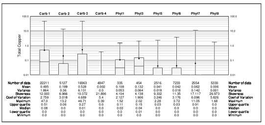
Figure 14.9: Boxplot of Copper by Probability Shell Domain
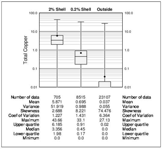
| NovaCopper Inc. | 14-79 | |
| NI 43-101 Technical Report on the Bornite Project, | ||
| Northwest Alaska |
| 14.4.2 | CONTACT PROFILES |
|
Contact profiles evaluate the nature of grade trends between two domains; they graphically display the average grades at increasing distances from the contact boundary. Those contact profiles that show a marked difference in grades across a domain boundary indicate that the two datasets should be isolated during interpolation. Conversely, if a more gradual change in grade occurs across a contact, the introduction of a hard boundary (in other words, segregation during interpolation) may result in much different trends in the grade model; in this case, the change in grade between model domains is often more abrupt than the trends seen in the raw data. Finally, a flat contact profile indicates that there are no grade changes across the boundary; in this case, hard or soft domain boundaries will produce similar results in the model. | |
|
A series of contact profiles were generated to evaluate the copper trends between various domains. Figure 14.10 shows an abrupt change in grade at the contact between samples in the carbonate and phyllite domains indicating that data contained in these should remain segregated during block grade estimations. |
| NovaCopper Inc. | 14-80 | |
| NI 43-101 Technical Report on the Bornite Project, | ||
| Northwest Alaska |
Figure 14.10: Contact Profile of Copper in Carbonate vs. Phyllite Domains
![]()
| NovaCopper Inc. | 4-114-81 | |
| NI 43-101 Technical Report on the Bornite Project, | ||
| Northwest Alaska |
Figure 14.11: Contact Profile of Copper in 2% vs. 0.2% Copper Shells
Figure 14.11 compares samples in the 2% Cu shell with samples in the surrounding 0.2% Cu shell. At the scale of the (5 m) block size in the model, there is a pronounced change in grade at this boundary suggesting that it should be recognized during block grade estimation.
Restricted to samples in carbonate rocks, Figure 14.12 shows a relatively distinct change in copper grade at the 0.2% Cu shell boundary. This is an indication that the 0.2% Cu shell does, in general, segregate mineralized from un-mineralized rocks.
| NovaCopper Inc. | 14-82 | |
| NI 43-101 Technical Report on the Bornite Project, | ||
| Northwest Alaska |
Figure 14.12: Contact Profile of Copper In/Out of the 0.2% Cu Shell in Carbonate Rocks
| 14.4.3 |
MODELLING IMPLICATIONS |
|
The boxplot and contact profiles analysis shows distinct differences in sample data contained in carbonate and phyllite domains and that these data should remain segregated during the estimation of copper grades in the block model. Analysis of the probability grade shells also indicate that these encompass differing populations of samples that should not be mixed during copper grade interpolations. | |
|
Based on these results, a combination of lithology and probability grade shell domains are used to control the distribution of copper in the resource block model. These “estimation domains” are summarized in Table 14.3. |
| NovaCopper Inc. | 14-83 | |
| NI 43-101 Technical Report on the Bornite Project, | ||
| Northwest Alaska |
Table 14.3: Summary of Copper Estimation Domains
| Estimation Domain | Lithology | Probability Grade Shell | Comments |
| ESTDM 1 | Carb 1 and 2 | Inside 2%Cu Shell | Primarily in the South Reef area. |
| ESTDM2a Ruby Creek |
Carb 1 and 2 | Inside 0.2%Cu Shell | Contains Lower Reef at Ruby Creek |
| ESTDM2b South Reef |
Carb 1 and 2 | Inside 0.2%Cu Shell | South Reef area |
| ESTDM3 | Carb 3 | Inside 0.2%Cu Shell | Contains Upper Reef at Ruby Creek |
| ESTDM4 | Carbonate | Outside 0.2%Cu Shell | Weak/un-mineralized carbonate rocks. |
| ESTDM5 | Phyllite | No shells | Weak/un-mineralized phyllite rocks |
| ESTDM6 | Carb 3 and 4 | Inside 2%Cu Shell | High-grade zone in Upper Reef part of Ruby Creek. |
Note that ESTDM2 has been separated into two areas in response to the fact that there are subtle differences in the nature (grade distribution and trends) between samples in the Lower Reef at Ruby Creek and South Reef. Separation ensures that these properties are appropriately replicated in the resource model.
Figure 14.13 is a boxplot showing the distribution of copper in the final estimation domains.
| NovaCopper Inc. | 14-84 | |
| NI 43-101 Technical Report on the Bornite Project, | ||
| Northwest Alaska |
Figure 14.13: Boxplot of Copper in Estimation Domains
| 14.5 |
TREATMENT OF OUTLIER GRADES |
|
Histograms and probability plots were generated from 2 m composited sample data to show the distribution of copper in each estimation domain. These were used to identify the existence of anomalous outlier grades in the composite database. The physical locations of these potential outlier samples were reviewed in relation to the surrounding data and it was decided that their effects could be controlled using a combination of traditional top-cutting and/or through the use of outlier limitations. An outlier limitation approach limits samples above a defined threshold to a maximum distance of influence during grade estimates. The distances are variable based on factors such as drill hole spacing and nature of the samples in question. | |
|
Table 14.4 summarizes the treatment of outlier sample data and the resulting effects on the estimate of contained metal in the models. |
| NovaCopper Inc. | 14-85 | |
| NI 43-101 Technical Report on the Bornite Project, | ||
| Northwest Alaska |
Table 14.4: Summary of Treatment of Outlier Copper Sample Data
| Estimation Domain |
Maximum (Cu %) |
Top-Cut limit (Cu %) |
Outlier limit (Cu%/range) |
Loss Cu-metal in model |
| ESTDM 1 | 43.66 | 30 | 12%/50m | -13.7% |
| ESTDM2a Ruby Creek |
13.77 | n/a | 9%/25m | -0.5% |
| ESTDM2b South Reef |
9.16 | n/a | 5%/50m | -4.5% |
| ESTDM3 | 33.10 | n/a | 8%/25m | -5.3% |
| ESTDM4 | 27.13 | 5 | 2%/25m | -10.9% |
| ESTDM5 | 9.38 | 5 | 3%/25m | -5.4% |
| ESTDM6 | 43.46 | n/a | 15%/10m | -21.5% |
|
The amount of metal lost in the 2% Cu Shell (ESTDM1) is an indication that additional drilling is required to increase the confidence in this area of the deposit. ESTDM6 contains some very high-grade samples resulting in a significant loss in contained copper following the treatment of potentially outlier sample data. This domain is quite small in relation to the overall Bornite deposit and requires additional close-spaced drilling to better understand the nature of this high-grade mineralization. Overall, there is a loss of about 5 percent copper metal in the Ruby Creek area and a loss of about 8 percent in the South Reef area. This is considered appropriate for a deposit of this type and at this stage of exploration. | |
| 14.6 |
SPECIFIC GRAVITY DATA |
|
Specific gravity (SG) measurements have been conducted on 4,472 samples in the database and range from a minimum of 2.12 t/m3 to a maximum of 4.94 t/m3 and average 2.91 t/m3. Approximately 40 percent of the available SG data occurs in the probability grade shell domains. The remaining SG data represent phyllite and carbonate rocks outside of the grade shells. Copper content and SG are moderately correlated. There is little variation in the SG values in the various estimation domains with correlation coefficient values typically less than 0.1. | |
|
SG measurements are available in the majority of drill holes at South Reef. At Ruby Creek, SG data is available in only 53 drill holes including all recent holes drilled by NovaCopper and some additional testing of Kennecott drill holes during re-logging in the summer of 2013. SG measurements are typically made at 10 to 20 m intervals down drill holes with the frequency increasing in the mineralized areas. | |
|
The distribution of SG data is considered sufficient to support estimation in the resource model. The relatively low variability in the sample data indicates that SG values can be estimated into model blocks using inverse distance squared moving averages. The copper grade estimation domains are used as hard boundaries during the estimation of densities in the model. |
| NovaCopper Inc. | 14-86 | |
| NI 43-101 Technical Report on the Bornite Project, | ||
| Northwest Alaska |
| 14.7 |
VARIOGRAPHY |
|
The degree of spatial variability and continuity in a mineral deposit depends on both the distance and direction between points of comparison. Typically, the variability between samples is proportionate to the distance between samples. If the variability is related to the direction of comparison, then the deposit is said to exhibit anisotropic tendencies which can be summarized by an ellipse fitted to the ranges in the different directions. The semi-variogram is a common function used to measure the spatial variability within a deposit. | |
|
The components of the variogram include the nugget, the sill, and the range. Often samples compared over very short distances (including samples from the same location) show some degree of variability. As a result, the curve of the variogram often begins at a point on the y-axis above the origin; this point is called the nugget. The nugget is a measure of not only the natural variability of the data over very short distances, but also a measure of the variability which can be introduced due to errors during sample collection, preparation, and assay. | |
|
Typically, the amount of variability between samples increases as the distance between the samples increase. Eventually, the degree of variability between samples reaches a constant or maximum value; this is called the sill, and the distance between samples at which this occurs is called the range. | |
|
The spatial evaluation of the data was conducted using a correlogram instead of the traditional variogram. The correlogram is normalized to the variance of the data and is less sensitive to outlier values; this generally gives cleaner results. | |
|
Variograms were generated for the distribution of copper in each of the estimation domains using the commercial software package Sage 2001© developed by Isaacs & Co. Variograms were generated using elevations relative to the trend planes described in section 14.3 of this report. This ensures that the local undulations of the typically banded mineralization are replicated in the block model. The variograms are summarized in Table 14.5. |
| NovaCopper Inc. | 14-87 | |
| NI 43-101 Technical Report on the Bornite Project, | ||
| Northwest Alaska |
Table 14.5: Variogram Parameters
| Domain | Nugget | S1 | S2 | 1st Structure | 2nd Structure | ||||
| Range (m) |
AZ | Dip | Range (m) |
AZ | Dip | ||||
| ESTDM 1 and 6 |
0.200 | 0.774 | 0.026 | 42 | 252 | 38 | 421 | 42 | 5 |
| Spherical | 14 | 29 | 43 | 306 | 135 | 32 | |||
| 11 | 322 | -23 | 49 | 123 | -57 | ||||
| ESTDM2a Ruby Creek |
0.150 | 0.656 | 0.194 | 22 | 23 | 53 | 537 | 25 | 2 |
| Spherical | 20 | 119 | 4 | 143 | 116 | 25 | |||
| 6 | 212 | 37 | 31 | 292 | 65 | ||||
| ESTDM2b South Reef |
0.150 | 0.699 | 0.151 | 84 | 319 | 45 | 137 | 281 | 65 |
| Spherical | 19 | 242 | -13 | 133 | 90 | 24 | |||
| 6 | 164 | 42 | 11 | 2 | -4 | ||||
| ESTDM3 | 0.100 | 0.798 | 0.102 | 14 | 355 | 86 | 463 | 130 | 81 |
| Spherical | 8 | 65 | -1 | 379 | 30 | 2 | |||
| 5 | 154 | 4 | 43 | 120 | -9 | ||||
| ESTDM4 | 0.150 | 0.765 | 0.085 | 10 | 19 | -5 | 622 | 3 | 23 |
| Spherical | 9 | 296 | 55 | 120 | 183 | 67 | |||
| 5 | 105 | 35 | 41 | 93 | 0 | ||||
| ESTDM5 | 0.150 | 0.738 | 0.112 | 20 | 301 | 68 | 808 | 238 | 13 |
| Spherical | 8 | 230 | -8 | 167 | 359 | 66 | |||
| 5 | 144 | 21 | 161 | 143 | 20 | ||||
Notes: Correlograms generated from 2 m composited sample data using elevations relative to trend plane of mineralization.
| 14.8 | MODEL SETUP AND LIMITS |
|
A block model was initialized with the dimensions shown in Table 14.6. A nominal block size of 5 x 5 x 5 m is considered appropriate, based on current drill hole spacing, for a project at this stage of evaluation. Since the deposit contains both underground and open pit potential resource, the 5 x 5 x 5 m selective mining unit (SMU) is primarily driven by the underground extraction potential of the deposit. Evaluations of the open pit extraction potential of the resource may require combining these blocks into a larger- scale SMU size. Further engineering studies are required to evaluate the viability of the Bornite deposits. The limits of the block model are represented by the purple rectangle shown in the previous isometric views (Figure 14.1, Figure 14.2, Figure 14.6 and Figure 14.7). |
| NovaCopper Inc. | 14-88 | |
| NI 43-101 Technical Report on the Bornite Project, | ||
| Northwest Alaska |
Table14.6: Block Model Limits
| Direction | Minimum (m) | Maximum (m) |
Block size (m) | Number of Blocks |
| X-axis (W-E) | 588800 | 590800 | 5 | 400 |
| Y-axis (N-S) | 7439300 | 7440900 | 5 | 320 |
| Elevation | -600 | 450 | 5 | 210 |
|
Using the domain wireframes, blocks in the model are assigned estimation domain code values on a majority basis. Blocks with more than 50 percent of their volume inside a wireframe domain are assigned a zone code value of that domain. | |
| 14.9 |
INTERPOLATION PARAMETERS |
|
Copper grades in model blocks were estimated using ordinary kriging. The ordinary kriging models were evaluated using a series of validation approaches as described in Section 14.12 of this report. The interpolation parameters have been adjusted until the appropriate results were achieved. In general, the ordinary kriging models have been generated using a relatively limited number of composited sample data. This approach reduces the amount of smoothing (also known as averaging) in the model and, while there may be some uncertainty on a localized scale, this approach produces reliable estimates of the potentially recoverable grade and tonnage for the overall deposit. Interpolation parameters for the various estimation domains are summarized in Table 14.8. |
| NovaCopper Inc. | 14-89 | |
| NI 43-101 Technical Report on the Bornite Project, | ||
| Northwest Alaska |
Table14.7: Interpolation Parameters
| Domain | Search Ellipse Range (m) | Number of composites (2 m) | Other | ||||
| X | Y | Z (1) | Min/block | Max/block | Max/hole | ||
| ESTDM 1 | 500 | 500 | 7 | 1 | 15 | 5 | 1DH per Octant |
| ESTDM2a Ruby Creek |
500 | 500 | 7 | 1 | 12 | 4 | 1DH per Octant |
| ESTDM2b South Reef |
500 | 500 | 7 | 1 | 15 | 5 | 1DH per Octant |
| ESTDM3 | 500 | 500 | 7 | 1 | 12 | 4 | 1DH per Octant |
| ESTDM4 | 500 | 500 | 7 | 1 | 15 | 5 | 1DH per Octant |
| ESTDM5 | 500 | 500 | 7 | 1 | 15 | 5 | 1DH per Octant |
| ESTDM6 | 500 | 500 | 7 | 1 | 20 | 5 | 1DH per Octant |
| Specific Gravity |
500 | 500 | 25 | 1 | 21 | 7 | ID2 |
1) Vertical range relative to distances from trend plane of mineralization
|
During grade and SG estimation, search orientations were designed to follow the mineralization trend surface interpreted to represent the general trend of the mineralization in the deposit. Although the maximum XY range is set at 500 m, estimation of block grades is limited to the nearest 3 or 4 drill holes; this criterion is typically met within a maximum distance of less than 150 m. | |
|
Block estimates of specific gravity are done using the inverse distance (ID2) interpolation method and all estimation domains were recognized as hard boundaries. | |
| 14.10 |
BLOCK MODEL VALIDATION |
|
The block models were validated through several methods: a thorough visual review of the model grades in relation to the underlying drill hole sample grades; comparisons with the change of support model; comparisons with other estimation methods; and, grade distribution comparisons using swath plots. | |
| 14.10.1 |
VISUAL INSPECTION |
|
Detailed visual inspection of the block model was conducted in both section and plan to compare estimated grades against underlying sample data. This included confirmation of the proper coding of blocks within the respective zone domains. Examples of the |
| NovaCopper Inc. | 14-90 | |
| NI 43-101 Technical Report on the Bornite Project, | ||
| Northwest Alaska |
distribution of copper grades in the block model are shown in cross section in Figure 14.14 and Figure 14.15.
Figure 14.14: North-South Vertical Section of Copper Estimates in the Block Model in the Ruby Creek Area
![]()
Figure 14.15: North-South Vertical Section of Copper Estimates in the Block Model in the South Reef Area
![]()
| NovaCopper Inc. | 14-91 | |
| NI 43-101 Technical Report on the Bornite Project, | ||
| Northwest Alaska |
| 14.10.2 |
Model Checks for Change of Support |
|
The relative degree of smoothing in the block estimates was evaluated using the Hermitian Polynomial Change of Support (Herco) method, also known as the Discrete Gaussian Correction (Journel and Huijbregts, 1978). With this method, the distribution of the hypothetical block grades can be directly compared to the estimated ordinary kriging model through the use of pseudo-grade/tonnage curves. Adjustments are made to the block model interpolation parameters until an acceptable match is made with the Herco distribution. In general, the estimated model should be slightly higher in tonnage and slightly lower in grade when compared to the Herco distribution at the projected cut-off grade. These differences account for selectivity and other potential ore-handling issues which commonly occur during mining. | |
|
The Herco distribution is derived from the declustered composite grades which have been adjusted to account for the change in support moving from smaller drill hole composite samples to the larger blocks in the model. The transformation results in a less skewed distribution, but with the same mean as the original declustered samples. | |
|
Examples of Herco plots from the prominent copper-bearing estimation domains are shown in Figure 14.16 and Figure 14.17. |
| NovaCopper Inc. | 14-92 | |
| NI 43-101 Technical Report on the Bornite Project, | ||
| Northwest Alaska |
Figure 14.16: Herco and Model Grade/Tonnage Plots for the 2%Cu Shell and Upper Reef 0.2% Cu Shell Domains
![]()
Figure 14.17: Herco and Model Grade/Tonnage Plots for the0.2% Cu Shell at South Reef and Ruby Creek Areas
![]()
|
Overall, the desired degree of correlation between models has been achieved. It should be noted that the change of support model is a theoretical tool intended to direct model estimation. There is uncertainty associated with the change of support model, and its results should not be viewed as a final or correct value. | |
| 14.10.3 |
Comparison of Interpolation Methods |
|
For comparison purposes, additional grade models were generated using the inverse distance weighted (ID) and nearest neighbour (NN) interpolation methods. The NN model was created using data composited to 5 m lengths to ensure all sample data are used in the model. The results of these models are compared to the ordinary kriging (OK) models at various cut-off grades using a grade/tonnage graph. The example in Figure 14.18 compares models within the combined 2% Cu and 0.2% Cu shells (ESTDM 1, 2 3 and 6). There is good correlation between model types. The correspondence among the grade tonnage curves is typical for the interpolation methods being compared. The NN interpolation always has the higher grade and lower tonnage. It is an estimate that should produce a value close to the correct global mean at zero cutoff grade. The NN grades and tonnages above cutoff are correct under the assumption that perfect selection of material above and below the cutoff can be executed at the scale of the composite samples. It is included to show the results of the averaging that takes place in the other two methods. The ordinary kriging curves show the lowest grades and highest tonnages. The correct amount of averaging for the chosen block size is insured for the ordinary kriging by the change of support calculation described in the preceding section. |
| NovaCopper Inc. | 14-93 | |
| NI 43-101 Technical Report on the Bornite Project, | ||
| Northwest Alaska |
Figure 14.18: Comparison of Copper Model Typesin Carbonates inside Grade Shell Domains
![]()
| 14.10.4 | Swath Plots (Drift Analysis) |
|
A swath plot is a graphical display of the grade distribution derived from a series of bands, or swaths, generated in several directions throughout the deposit. Using the swath plot, grade variations from the ordinary kriging model are compared to the distribution derived from the declustered nearest neighbour grade model. |
| NovaCopper Inc. | 14-94 | |
| NI 43-101 Technical Report on the Bornite Project, | ||
| Northwest Alaska |
On a local scale, the nearest neighbour model does not provide reliable estimations of grade, but, on a much larger scale, it represents an unbiased estimation of the grade distribution based on the underlying data. Therefore, if the ordinary kriging model is unbiased, the grade trends may show local fluctuations on a swath plot, but the overall trend should be similar to the nearest neighbour distribution of grade.
Swath plots were generated in three orthogonal directions that compare the ordinary kriging and nearest neighbour estimates for copper in each of the estimation domains.
Examples from the carbonate rocks inside the grade shells (ESTDM 1, 2, 3 and 6) are shown by easting and northing in Figure 14.19.
Figure 14.19: Swath plots of Copper in Carbonates Inside Grade Shells
![]()
|
There is very good correspondence over most of the model area. The degree of smoothing is evident in the distribution of the OK model. The wider-spaced drilling, with the more variable and higher-grade nature at South Reef, results in a more erratic distribution in the NN model. The more significant differences are attributed to several (new) down-dip holes at the north and northeast edges of the South Reef deposit. | |
|
The validation results indicate that the OK model is a reasonable reflection of the underlying sample data. | |
| 14.11 |
RESOURCE CLASSIFICATION |
|
The mineral resources were classified in accordance with the CIM Definition Standards for Mineral Resources and Mineral Reserves (November, 2010). The classification parameters are defined relative to the distance between sample data and are intended to encompass zones of reasonably continuous mineralization that exhibit the desired degree of confidence in the estimate. |
| NovaCopper Inc. | 14-95 | |
| NI 43-101 Technical Report on the Bornite Project, | ||
| Northwest Alaska |
Classification parameters are generally linked to the scale of a deposit; a large and relatively low-grade porphyry type deposit would likely be mined at a much higher daily rate compared to a narrow, high-grade, deposit. The scale of selectivity of these two examples differs significantly and this is reflected in the drill hole spacing required to achieve a desired level of confidence in defining a volume of material that represents, say, a year of production. At this stage of evaluation of the Bornite deposit, it is becoming apparent that it may be amenable to a combination of open pit and underground extraction methods. The actual scale of extraction is unknown at this stage and further engineering work is required in order to gain a better understanding of these concepts. Rather than propose a new classification scheme that could be subject to future change, it has been decided to retain the approach that was used for the previous resource estimates. Although these criteria for Indicated resources may be considered conservative for an open pit type of operation of this size, scale and location, it is felt that this approach is better than to attempt to define parameters based on a (current) limited understanding of the input parameters.
Both copper grade and indicator variograms were evaluated to provide information regarding the range of continuity of mineralization. This was combined with visual observations regarding the nature of the deposits with respect to the distribution of available sample information. The following classification criteria are defined for the Bornite deposit:
| • |
Indicated Mineral Resources includes blocks in the model that are within a maximum average distance of 35 m from three or more drill holes and exhibit a relatively high degree of confidence in the grade and continuity of mineralization. This is achieved with drilling on a nominal 50 m grid pattern. | |
| • |
Inferred Mineral Resources require a minimum of one drill hole within a maximum distance of 100 m and exhibit reasonable confidence in the grade and continuity of mineralization. |
|
Some manual “smoothing” of these criteria was conducted that includes areas where the drill hole spacing locally exceeds the desired grid spacing, but still retains continuity of mineralization or, conversely, excludes areas where the mineralization does not exhibit the required degree of confidence. This process resulted in two areas in the Ruby Creek area that contain resources in the Indicated category. | |
| 14.12 |
MINERAL RESOURCE ESTIMATE |
|
CIM Definition Standards for Mineral Resources and Mineral Reserves (November 2010) defines a mineral resource as: |
| NovaCopper Inc. | 14-96 | |
| NI 43-101 Technical Report on the Bornite Project, | ||
| Northwest Alaska |
“(A) concentration or occurrence of diamonds, natural solid inorganic material, or natural solid fossilized organic material including base and precious metals, coal, and industrial minerals in or on the Earth’s crust in such form and quantity and of such grade or quantity that it has reasonable prospects for economic extraction. The location, quantity, grade geological characteristics and continuity of a Mineral Resource are known, estimated or interpreted from specific geological evidence and knowledge”.
The Bornite deposit comprises several zones of relatively continuous moderate to high-grade copper mineralization that extends from surface, to depths of over 800 m below surface. The deposit is potentially amenable to a combination of open pit and underground extraction methods. The “reasonable prospects of economic extraction” was tested using a floating cone pit shell derived based on a series of technical and economic assumptions considered appropriate for a deposit of this type, scale and location. These parameters are summarized as follows:
Table 14.8: Parameters Used to Generatea Resource Limiting Pit Shell
| Optimization Parameters | |
| Open Pit Mining Cost | $2/tonne |
| Milling Cost | $11/tonne |
| G&A | $5/tonne |
| Pit Slope | 43 degrees |
| Metallurgical Recovery | 87% |
| Copper Price | $3.00/lb |
* No adjustments for mining recovery or dilution
It is important to recognize that these discussions of underground and surface mining parameters are used solely for the purpose of testing the “reasonable prospects for economic extraction,” and do not represent an attempt to estimate mineral reserves. There are no mineral reserves calculated for the Bornite Project. These preliminary evaluations are used to assist with the preparation of a Mineral Resource Statement and to select appropriate reporting assumptions.
Using the parameters defined above, a pit shell was generated in the Ruby Creek area that extends to a depth of over 500 m below surface. Table 14.8 lists the mineral resources contained within and below the pit shell. The mineral resource estimate is reported at two cut-off grades; 0.35% Cu for material that is amenable to open pit extraction and 1.5% Cu for resources that occur below the pit shell. The cut-off grade of resources amenable to underground extraction is based on a mining cost $50/tonne. The distribution of mineral resources is presented with a series of isometric views in Figure 14.20.
There are no known factors related to environmental, permitting, legal, title, taxation, socio-economic, marketing, or political issues which could materially affect the mineral resource.
| NovaCopper Inc. | 14-97 | |
| NI 43-101 Technical Report on the Bornite Project, | ||
| Northwest Alaska |
Table 14.9: Mineral Resource Estimate for the Bornite Project
| Type | Cut-off (Cu %) |
M tonnes | Grade (Cu %) |
Contained Metal (Mlbs Cu) |
| Indicated | ||||
| In-Pit(1) | 0.5 | 14.1 | 1.08 | 334 |
| Inferred | ||||
| In-Pit(1) | 0.5 | 109.6 | 0.94 | 2,259 |
| Below-Pit | 1.5 | 55.6 | 2.81 | 3,437 |
| Total Inferred | 165.2 | 1.57 | 5,696 | |
| (1) |
Resources stated as contained within a pit shell developed using a metal price of US$3.00/lb Cu, mining costs of US$2.00/tonne, milling costs of US$11/tonne, G&A cost of US$5.00/tonne, 87% metallurgical recoveries and an average pit slope of 43 degrees. | |
| (2) |
Mineral Resources are not Mineral Reserves and do not have demonstrated economic viability. There is no certainty that all or any part of the Mineral Resources will be converted into Mineral Reserves. | |
| (3) |
Inferred resources have a great amount of uncertainty as to their existence and whether they can be mined legally or economically. It cannot be assumed that all or any part of the Inferred resources will ever be upgraded to a higher category. |
Figure 14.20: Isometric Views of Bornite Mineral Resource
![]()
| NovaCopper Inc. | 14-98 | |
| NI 43-101 Technical Report on the Bornite Project, | ||
| Northwest Alaska |
| 14.13 | GRADE SENSITIVITY ANALYSIS |
|
For information purposes, resources are summarized at a series of cut-off thresholds for resources within the pit shell in Table 14.9 and for resources below the pit shell in Table 14.10. The base case cut-off limit, about which the mineral resource statement has been derived, is highlighted. The reader is cautioned that the figures presented in these tables should not be misconstrued with a Mineral Resource Statement. The figures are only presented to show the sensitivity of the block model estimates to the selection of the cut-off grade. |
Table 14.10: Sensitivity of Mineral Resources Inside the Pit Shell
| Indicated | Inferred | |||||
| Cut-off (Cu %) |
M tonnes | Grade (Cu %) |
Contained Cu (Mlbs) |
M tonnes | Grade (Cu %) |
Contained Cu (Mlbs) |
| 0.2 | 18.5 | 0.91 | 370 | 136.1 | 0.82 | 2,460 |
| 0.25 | 17.9 | 0.93 | 367 | 130.2 | 0.85 | 2,434 |
| 0.3 | 17.4 | 0.95 | 364 | 126.5 | 0.87 | 2,412 |
| 0.35 | 16.8 | 0.97 | 360 | 123.4 | 0.88 | 2,389 |
| 0.40 | 16.1 | 1.00 | 354 | 119.8 | 0.89 | 2,359 |
| 0.45 | 15.1 | 1.04 | 345 | 115.4 | 0.91 | 2,319 |
| 0.50 | 14.1 | 1.08 | 334 | 109.6 | 0.94 | 2,259 |
| 0.55 | 12.9 | 1.13 | 321 | 102.8 | 0.96 | 2,180 |
| 0.60 | 11.8 | 1.18 | 307 | 95.2 | 0.99 | 2,086 |
| 0.65 | 10.8 | 1.23 | 293 | 86.9 | 1.03 | 1,972 |
| 0.70 | 9.8 | 1.29 | 278 | 78.5 | 1.07 | 1,847 |
| 1) |
Base Case cutoff grade of 0.50% Cu is highlighted in table. | |
| 2) |
Resources stated as contained within a pit shell developed using a metal price of US$3.00/lb Cu, mining costs of US$2.00/tonne, milling costs of US$11/tonne, G&A cost of US$5.00/tonne, 87% metallurgical recoveries and an average pit slope of 43 degrees. | |
| 3) |
Mineral Resources are not Mineral Reserves and do not have demonstrated economic viability. There is no certainty that all or any part of the Mineral Resources will be converted into Mineral Reserves. | |
| 4) |
Inferred resources have a great amount of uncertainty as to their existence and whether they can be mined legally or economically. It cannot be assumed that all or any part of the Inferred resources will ever be upgraded to a higher category. |
| NovaCopper Inc. | 14-99 | |
| NI 43-101 Technical Report on the Bornite Project, | ||
| Northwest Alaska |
Table 14.11: Sensitivity of Mineral Resources Below the Pit Shell
| Indicated | Inferred | |||||
| Cut-off (Cu %) |
M tonnes | Grade (Cu %) |
Contained Cu (Mlbs) |
M tonnes | Grade (Cu %) |
Contained Cu (Mlbs) |
| 0.5 | 0.01 | 0.63 | 0.16 | 264.5 | 1.27 | 7,418 |
| 1.0 | 0 | 0 | 0 | 113.6 | 1.99 | 4,972 |
| 1.5 | 0 | 0 | 0 | 55.6 | 2.81 | 3,437 |
| 2.0 | 0 | 0 | 0 | 40.9 | 3.21 | 2,887 |
| 2.5 | 0 | 0 | 0 | 32.0 | 3.48 | 2,448 |
| 3.0 | 0 | 0 | 0 | 22.3 | 3.79 | 1,859 |
| 1) |
Base Case cutoff grade of 1.50% Cu is highlighted in table. | |
| 2) |
Mineral Resources are not Mineral Reserves and do not have demonstrated economic viability. There is no certainty that all or any part of the Mineral Resources will be converted into Mineral Reserves. | |
| 3) |
Inferred resources have a great amount of uncertainty as to their existence and whether they can be mined legally or economically. It cannot be assumed that all or any part of the Inferred resources will ever be upgraded to a higher category. |
| 14.14 |
COMPARISON WITH THE PREVIOUS RESOURCE ESTIMATE |
|
The previous resource estimate for the Bornite Project was described in a technical report dated February 5, 2013. In that report, the Ruby Creek and South Reef zones were considered to be separate deposits and were calculated and reported accordingly. The estimation for the Ruby Creek zone was originally described in a technical report dated July 18, 2012 and this estimate was carried forward in the February 2013 report. The resource estimate from the February 2013 report is listed in Table 14.12 and compared to the current estimate in Table 14.13. |
Table 14.12: Estimate of Mineral Resources for the Bornite Project – February 2013
| Type | Cut-off (Cu %) |
M tonnes | Grade (Cu %) |
Contained Metal (Mlbs Cu) |
| Indicated | ||||
| Ruby Creek | 0.5 | 6.8 | 1.19 | 179 |
| Inferred | ||||
| Ruby Creek | 0.5 | 47.7 | 0.84 | 883 |
| South Reef | 1.0 | 43.1 | 2.54 | 2,409 |
| Total Inferred | 90.8 | 1.64 | 3,292 | |
| NovaCopper Inc. | 14-100 | |
| NI 43-101 Technical Report on the Bornite Project, | ||
| Northwest Alaska |
Table 14.13: Estimate of Mineral Resources for the Bornite Project – March 2014
| Type | Cut-off (Cu %) |
M tonnes | Grade (Cu %) |
Contained Metal (Mlbs Cu) |
| Indicated | ||||
| In-Pit | 0.50 | 14.1 | 1.08 | 334 |
| Inferred | ||||
| In-Pit | 0.50 | 109.6 | 0.94 | 2,259 |
| Below-Pit | 1.5 | 55.6 | 2.81 | 3,437 |
| Total Inferred | 165.2 | 1.57 | 5,696 | |
There is an 87percent increase in the amount of contained metal in the Indicated category (even though only about 6 percent of the current resource is in the Indicated category) and a 73 percent increase in contained metal in the Inferred category. Some comments regarding the changes in the Bornite resources are listed as follows:
| • |
The Ruby Creek resource (February, 2013) was limited within a manually generated pit shell that was restricted to near-surface mineralization in the Lower Reef. This was a much smaller pit shell than the one generated for the current resource. | |
| • |
The previous resource at South Reef (February, 2013) utilized a probability shell based on a 2% copper threshold to define two estimation domains within the Carbonate stratigraphy: inside the 2% Cu probability shell and outside the shell. This approach targeted only high-grade resources. The current model utilizes an additional probability shell based on a 0.2% Cu threshold. | |
| • |
Additional drilling has added significant resources down-dip in both the Ruby Creek and South Reef areas. | |
| • |
Additional sampling of the previously un-sampled core in Kennecott drill holes has added near-surface resources in the Ruby Creek area. | |
| • |
The change in the base case cut-off threshold from 1.0% to 1.5% Cu has resulted in a decrease in the amount of resources amenable to underground extraction. However, the overall below-pit resources have increased as a result of additional drilling and modifications to the estimation domains described above. |
| NovaCopper Inc. | 14-101 | |
| NI 43-101 Technical Report on the Bornite Project, | ||
| Northwest Alaska |
| 15.0 |
MINERAL RESERVE ESTIMATES |
The Bornite Project is an early exploration project; there are presently no mineral reserves at the Project.
| NovaCopper Inc. | 15-102 | |
| NI 43-101 Technical Report on the Bornite Project, | ||
| Northwest Alaska |
| 16.0 |
MINING METHODS |
The Bornite Project is an early exploration project; no mining methods have been investigated for the Project.
| NovaCopper Inc. | 16-103 | |
| NI 43-101 Technical Report on the Bornite Project, | ||
| Northwest Alaska |
| 17.0 |
RECOVERY METHODS |
The Bornite Project is an early exploration project; no recovery methods have been investigated for the Project.
| NovaCopper Inc. | 17-104 | |
| NI 43-101 Technical Report on the Bornite Project, | ||
| Northwest Alaska |
| 18.0 |
PROJECT INFRASTRUCTURE |
| 18.1 | ROAD |
|
Although all projects in the Ambler mining district are at the exploration or early development stage, including NovaCopper’s Bornite Project, NovaCopper and NANA are supporting the State of Alaska's efforts to develop infrastructure into the region under the ‘Alaska Road to Resources’ program. Between 2009 and 2012, the State of Alaska funded over $10 million to study access to the Ambler mining district. During that period, a working group consisting of ADOT, the Governor’s office, AIDEA, NANA, and NovaCopper was developed to advance the Project. An additional $8.5 million was budgeted by the Alaskan government for permitting activities during the 2013/2014 fiscal year. | |
|
Efforts from 2009 to 2011 focused on identifying optimal access routes and, after input from local communities and a review of a series of options, the Brooks East Access Route was chosen for further assessment. In 2012, the Alaska State Legislature approved an additional $4 million to allow the ADOT to initiate environmental baseline studies on the Brooks East Access Route connecting the Ambler mining district with the Dalton Highway 322 km to the east. In the fall of 2012, a Project description was prepared by the Project proponent to finalize the proposed action and identify the lead federal agency for impact analysis and determine the state and federal cooperating agencies to assure permit coordination. This work will lead to the completion of a draft Environmental Impact Statement (EIS) in early 2014. Figure 18.1 shows the preferred access option (Brooks East Access Route) in blue, and a variation of the route in yellow. Also, initial meetings between all of the permitting and licensing agencies and initial community engagement meetings were held in August 2013. | |
| 18.2 |
POWER |
|
NovaCopper is investigating the viability of using liquefied natural gas (LNG) as a potential power source for the Bornite Project. In July 2013, AIDEA published a feasibility study to investigate the viability of trucking LNG to Fairbanks so as to supply local utilities which would use the LNG to fuel their power generation plants. The feasibility study estimated that the use of LNG could significantly lower electrical power generation costs in Fairbanks. In January, 2014 AIDEA selected a commercial participant to develop a North Slope LNG liquefaction plant that will produce LNG for delivery to the Fairbanks North Star Borough via trucking. |
| NovaCopper Inc. | 18-105 | |
| NI 43-101 Technical Report on the Bornite Project, | ||
| Northwest Alaska |
Figure 18.1: Brooks East Route Access to the UKMP and Location of North Slope LNG (NovaCopper, 2014)
![]()
| NovaCopper Inc. | 18-106 | |
| NI 43-101 Technical Report on the Bornite Project, | ||
| Northwest Alaska |
Figure 18.2: Brooks East Route Access to the UKMP – Preferred Route (NovaCopper, 2012)
![]()
| NovaCopper Inc. | 18-107 | |
| NI 43-101 Technical Report on the Bornite Project, | ||
| Northwest Alaska |
| 19.0 |
MARKET STUDIES AND CONTRACTS |
The Bornite Project is an early exploration project; no market studies have been completed.
| NovaCopper Inc. | 19-108 | |
| NI 43-101 Technical Report on the Bornite Project, | ||
| Northwest Alaska |
| 20.0 |
ENVIRONMENTAL STUDIES, PERMITTING AND SOCIAL OR COMMUNITY IMPACT |
|
This section characterizes the existing and ongoing environmental baseline data collection for the Bornite Project area, makes suggestions for additional studies that would provide a basis for the eventual mine permitting efforts, describes the major environmental permits that will likely be required for the Bornite Project, and identifies potential significant social or community impacts. | |
| 20.1 |
ENVIRONMENTAL STUDIES |
|
The Bornite Project area includes NANA’s Bornite and ANCSA lands, the Ruby Creek drainage (a tributary of the Shungnak River), the Shungnak River drainage, and portions of the Ambler Lowlands. Since 2007, baseline environmental data collection has occurred in the area including archaeology, aquatic life surveys, sediment sampling, wetlands mapping, surface water quality sampling, hydrology, meteorological monitoring, and subsistence. The existing data are summarized in Sections 20.1.1 to 20.1.7. | |
| 20.1.1 |
ARCHAEOLOGY |
|
Limited work was done in 2008 by Northern Land Use Research Inc. (NLUR Inc.) to identify sites that could have potential cultural significance within the Bornite Project area. NLUR concluded "No Historic Properties Affected" with regards to the 2008 work plan. | |
| 20.1.2 |
AQUATIC LIFE AND FISHERIES |
|
All aquatic life and fisheries sampling efforts were conducted in 2010 by TetraTech Inc. Tetra Tech’s sampling efforts included baseline aquatic life surveys in the area along the proposed road alternatives between the Bornite airstrip and Arctic airstrip, and along the Arctic airstrip to Arctic Deposit road in Subarctic Creek. The purpose of this study was to characterize the aquatic life within the Shungnak River and potentially impacted tributaries. Opportunistic observations were also collected in the Kogoluktuk River. Fish and macroinvertebrate data were collected from July 8 to 14, 2010. | |
| 20.1.3 |
ECOSYSTEM AND SOILS |
|
Soil sampling was done in 2011 to determine the presence of naturally occurring asbestos (NOA). Sampling was done at the Bornite Camp, Bornite Airstrip, and along the Kobuk to Bornite Road. Analysis of the samples was conducted using a Polarized Light Microscopy (PLM) detection method. |
| NovaCopper Inc. | 20-109 | |
| NI 43-101 Technical Report on the Bornite Project, | ||
| Northwest Alaska |
|
Wetlands delineation was done in 2010 for the road corridor between the Bornite Airstrip and the Arctic Airstrip by TetraTech using the standard three-parameter approach required by the US Army Corps of Engineers. Thirty-three sampling locations were evaluated reflecting the fourteen vegetation communities observed in the field. Vegetation communities were characterized using the Alaska Vegetation Classification system. A wetlands map for the Bornite Project Area was produced in 2011 using aerial photography and extrapolating data collected during the 2010 wetlands study. | |
| 20.1.4 |
HYDROLOGY |
|
Surface water quality sampling has been conducted within the Bornite Project area since 2007, with the exceptions of 2009 and 2011. Samples were analyzed for dissolved metals, total metals, and common environmentally significant parameters including pH, conductivity, dissolved oxygen and nitrates. Velocity, depth, width and discharge (cubic feet per second) were measured using a Marsh McBirney current meter. | |
|
Two hydrologic gauging stations have been installed within the Bornite Project area, one on Ruby Creek and one on the Shungnak River. These stations measure the height of the water, pH, and conductivity. | |
| 20.1.5 |
METEOROLOGY, AIR QUALITY, AND NOISE |
|
Meteorological data have been collected year round at the Arctic Airstrip since September, 2011. Site data has been collected hourly for humidity, barometric pressure, precipitation, solar radiation, temperature, wind speed, and wind direction. | |
| 20.1.6 |
SUBSISTENCE |
|
In 2012, Stephen R. Braund & Associates completed a subsistence data gap analysis under contract to the Alaska Department of Transportation and Public Facilities as part of the baseline studies associated with a proposed road to the Ambler mining district. The purpose of this analysis was to identify what subsistence research had been conducted for the potentially affected communities, determine if subsistence uses and use areas overlap with or may be affected by the project, and identify what, if any, additional information (i.e., data gaps) needed to be collected in order to accurately assess potential effects to subsistence. |
| NovaCopper Inc. | 20-110 | |
| NI 43-101 Technical Report on the Bornite Project, | ||
| Northwest Alaska |
Table 20.1: Summary of Existing Environmental Baseline Studies Reports
| Discipline | Year | Report Title | Author |
| Archaeology | 2008 | Assessment of Cultural Resources and Site Potential of Proposed Geologic Exploration Drill Areas | Neely, Burr and Proue, Molly (NLUR Inc.) |
| Aquatic Life and Fisheries |
2010 | Arctic Deposit Access Environmental Baseline Data Collection Aquatics | TetraTech Inc. |
| Ecosystem and Soils | 2010 | Arctic Deposit Access Environmental Baseline Data Collection Wetlands & Vegetation | TetraTech Inc. |
| 2011 | Ambler Project Asbestos Soil Sampling Report | Craig, Cal (NovaCopper) | |
| Hydrology | 2007 | Environmental Baseline Sampling Alaska Gold | Crupi, Steven (Shaw Inc.) |
| 2008 | Shaw Hydraulics Data Report | Crupi, Steven (Shaw Inc.) | |
| 2008 | Trip Report-Arctic Deposit and Bornite August 13-18, 2008 | Bergstrom, Frank (Amerikanuak Inc.) | |
| 2008 | Water Quality Report | Crupi, Steven (Shaw Inc.) | |
| 2009 | Hydraulics Data Report | Crupi, Steven (Shaw Inc.) | |
| 2009 | Water Quality Report | Crupi, Steven (Shaw Inc.) | |
| 2010 | Arctic Deposit Access Environmental Baseline Data Collection Hydrology | TetraTech Inc. | |
| 2012 | Stream Gauge Install | DOWL HKM | |
| 2012 | Water Quality Monitoring Report: Fall 2012 | Craig, Cal (NovaCopper) | |
| 2012 | NovaCopper Weather Station and Streamflow Gauging Data Collection Year-End Report | DOWL HKM | |
| 2013 | Water Quality Monitoring Report: First Quarter 2013 | Craig, Cal (NovaCopper) | |
| 2013 | Water Quality Monitoring Report: Second Quarter 2013 | Craig, Cal (NovaCopper) | |
| Meteorology, Air Quality, and Noise |
2012 | NovaCopper Weather Station and Streamflow Gauging Data Collection Year-End Report | DOWL HKM |
| Subsistence | 2012 | Ambler Mining District Access Project Subsistence Data Gap Memo | Braund, Stephen
(Stephen R. Braund and Associates ) |
| NovaCopper Inc. | 20-111 | |
| NI 43-101 Technical Report on the Bornite Project, | ||
| Northwest Alaska |
| 20.1.7 | ADDITIONAL BASELINE DATA REQUIREMENTS |
|
Additional baseline environmental data in NANA’s Bornite and ANCSA lands, the Ruby Creek drainage, the Shungnak River drainage, portions of the Ambler Lowlands, and downstream receiving environments will be required to support future mine design, development of an EIS, permitting, construction and operations. NovaCopper will consult with state, local and federal regulatory agencies and their consultants to further develop a comprehensive environmental baseline program. Owing to the long lead-time to collect data (years), it is important that the comprehensive environmental baseline program generates adequate data in terms of type, quality and quantity for each of the disciplines of interest. Recommendations for additional baseline studies are included in Table 20.2. |
Table 20.2: Additional Recommended Environmental Baseline Studies
| Discipline | Recommended Studies |
| Acid-Base Accounting | Static test work of waste domains within and adjacent to the proposed open pit, potential underground resources, and static investigation of borrow sources and tailings followed by kinetic test work. |
| Archaeology | Assessment of cultural resources, cultural site clearance |
| Aquatic Life | Expanded aquatic surveys (invertebrates) |
| Ecosystem and Soils | Permafrost and wetlands delineation mapping; vegetation surveys |
| Fisheries | Expanded fisheries surveys |
| Hydrogeology | Installation and monitoring of groundwater wells in the Ruby Creek drainage areas near the site of, and down gradient of, any proposed pit, any proposed tailings and waste rock storage facilities and alternative sites for tailings and waste rock disposal locations |
| Hydrology | Snow survey |
| Meteorology, Air Quality, and Noise | Expansion of the meteorological program to additional locations to be determined; air quality monitoring |
| Wildlife | Avian survey, large mammal survey, analysis of subsistence resources |
All of the data are important to the development of an accurate environmental baseline and water balance model for the Bornite project area. These studies would need to be completed in sufficient depth to cover all reasonably foreseeable baseline work that may be requested by the regulatory agencies. The risks that come with insufficient baseline data include delays in the permitting process, poorly constrained pre-mining characterizations, inappropriate trigger levels in permits and inaccurate water balance models that can negatively affect operations and otherwise result in unforeseen and potentially costly circumstances during permitting or mine operations and closure.
| NovaCopper Inc. | 20-112 | |
| NI 43-101 Technical Report on the Bornite Project, | ||
| Northwest Alaska |
| 20.2 |
PERMITTING |
|
Development of the Bornite Project will require a significant number of permits and authorizations from state, federal, and regional organizations. Much of the groundwork to support a successful permitting effort must be undertaken prior to submission of permit applications so that issues can be identified and resolved, baseline data can be acquired, and regulators and stakeholders can become familiar with the proposed project. | |
|
The comprehensive permitting process for the Bornite Project can be divided into three categories: | |
|
Exploration state/regional permitting: required to obtain approval for drilling, camp operations, engineering, and environmental baseline studies. | |
|
Pre-application phase: conducted in conjunction with engineering feasibility studies. This stage includes the collection of environmental baseline data and interaction with stakeholders and regulators to facilitate the development of a project that can be successfully permitted. | |
|
The National Environmental Policy Act (NEPA) phase: formal agency review of the Federal and State requirements for public and agency participation to determine if and how the Project can be done in an acceptable manner. | |
|
Table 20.3 lists the typical permits that may be required for the Project. |
| NovaCopper Inc. | 20-113 | |
| NI 43-101 Technical Report on the Bornite Project, | ||
| Northwest Alaska |
Table 20.3: Permits that May Be Required for the Bornite Project
| Authority | Permit |
| FEDERAL | |
| Environmental Protection Agency (EPA) | Spill Prevention Containment and Contingency (SPCC) Plan |
| U.S. Army Corps of Engineers (USACE) | CWA Section 404 Permit (wetlands dredge and fill) |
| River and Harbors Act (RHA) Section 10 (structures in navigable waters) | |
| RHA Section 9 (dams and dykes in navigable waters-interstate commerce) | |
| U.S. Coast Guard | RHA Section 9 Construction Permit (bridge across navigable waters) |
| Bureau of Alcohol, Tobacco, and Firearms | License to Transport Explosives |
| Permit and License for Use of Explosives | |
| Federal Aviation Administration | Notice of Landing Area Proposal (existing airstrip) |
| Notice of Controlled Firing Area for Blasting | |
| U.S. Department of Transportation | Hazardous Materials Registration |
| U.S. Fish and Wildlife Service | Section 7 of the Endangered Species Act, Consultation requiring a Biological Assessment or Biological Opinion |
| STATE | |
| Division of Mining, Land, and Water | Plan of Operations |
| Reclamation Plan Approval | |
| Mining License | |
| Land Use Permits and Leases | |
| Right-of-Ways, Easements, Material Sales, etc. | |
| Certificate of Approval to Construct a Dam | |
| Certificate of Approval to Operate a Dam | |
| Temporary Water Use Permit | |
| Water Rights Permit/Certificate to Appropriate Water | |
| State Historic Preservation Office | Section 106 Historical and Cultural Resources Protection Act clearance |
| Department of Fish and Game | Fish Habitat Permit |
| Wildlife Hazing Permit | |
| Culvert/Bridge Installation Permit |
| NovaCopper Inc. | 20-114 | |
| NI 43-101 Technical Report on the Bornite Project, | ||
| Northwest Alaska |
Table 20.3: Permits that May Be Required for the Bornite Project–Cont’d
| Authority | Permit |
| FEDERAL | |
| Division of Water | Section 401 Water Quality Certification (CWA 402 permit) |
| Waste water Disposal Permits | |
| Non-Domestic Wastewater Disposal Permit | |
| Storm Water Discharge Pollution Prevention Plan | |
| Domestic Waste water Disposal Permit | |
| Approval to Construct and Operate a Public Water Supply System | |
| Division of Environmental Health | Solid Waste Disposal Permits |
| Food Sanitation Permit | |
| Class III Municipal Solid Waste Landfill Permit | |
| Division of Air Quality | Air Quality Construction Permit (first 12 months) |
| Air Quality PSD Title V Operating Permit (after 12 months) | |
| Air Quality permit to Open Burn | |
| REGIONAL | |
| Northwest Arctic Borough | Title 9 Land Use Permit |
| Fuel Storage Permit | |
| Commercial Transporter Authorization | |
| Master Plan of Operations |
|
The permit review process will determine the number of management plans required to address all aspects of the Project to ensure compliance with environmental design and permit criteria. Each plan will describe the appropriate environmental engineering standard and the applicable operations requirements, maintenance protocols, and response actions. | |
| 20.3 |
SOCIAL OR COMMUNITY CONSIDERATIONS |
|
The Bornite Project is located approximately 19 km north of the village of Kobuk, 23 km northeast of the village of Shungnak, and 40 km east of the village of Ambler. The population in these villages are 151 in Kobuk (2010 Census), 262 in Shungnak (2010 Census) and 258 in Ambler (2010 US Census). Residents live a largely subsistence lifestyle with incomes supplemented by trapping, guiding, local development projects, government aid and other work in, and outside of the villages. | |
|
The Bornite Project has the potential to significantly improve work opportunities for village residents in the region. NovaCopper is working directly with the villages to employ residents in the ongoing exploration program as geotechnicians, drill helpers, environmental technicians, and a myriad of other camp support positions. NovaCopper and NANA have established a Workforce Development Subcommittee to assist with developing a local workforce. In addition, NovaCopper has existing contracts with native-affiliated companies (such as NANA Management Services and WHPacific Inc.) that provide camp catering and environmental services for the project. |
| NovaCopper Inc. | 20-115 | |
| NI 43-101 Technical Report on the Bornite Project, | ||
| Northwest Alaska |
In October 2011, NovaCopper signed an agreement with NANA. In addition to consolidating landholdings in the Ambler mining district and Bornite, the agreement has language establishing native hiring preferences and preferential use of NANA subsidiaries for contract work. Furthermore, the agreement formalized an Oversight Committee, with equal representation from NovaCopper and NANA, to regularly review project plans and activities. The agreement also includes a scholarship funded annually by NovaCopper that promotes education opportunities for Shareholders in the region. NovaCopper meets monthly during the field season, with the residents of Kobuk, Shungnak and Ambler, the three villages closest to the project area. NovaCopper also meets annually with eight other NANA region villages including Noatak, Kivalina, Kotzebue, Kiana, Deering, Buckland, Selawik and Noorvik, for the purpose of updating residents on project plans and fielding their questions and concerns. NovaCopper has also developed a good working relationship with the NWAB government.
In general terms, rural Alaska residents are often concerned about potential mining impacts to wildlife and fish for those projects within their traditional use areas. NovaCopper acknowledges these views and concerns and is taking substantive steps to address them during the current exploration stage of the Bornite Project.
Local community concerns will also be formally recognized during the scoping stage at the beginning of the NEPA process. At that time, the lead federal agency (likely the USACE) will hold scoping meetings in rural villages to hear and record the concerns of the local communities so that they can be addressed during the development of the EIS. In addition, the USACE would have government-to-government consultations with the Tribal Councils in each of the villages, as part of the NEPA process, to discuss the project and discuss Council concerns.
Characterizing the level of support or opposition to the Bornite Project would be speculative at this time. A poll conducted by Dittman Research for the 2011 NANA Shareholder opinion survey asked if Shareholders supported or opposed road projects on NANA land to assist in economic and potential mineral development. Eighty-three percent supported the concept while fifteen percent opposed. Surveys of this sort show a broad support for infrastructure and of mineral development in the region as long as regional interests are met. Regional engagement by NovaCopper has also encountered a strong desire for the economic benefits that come with mining projects. However, like most mining projects there will likely be some opposition to this project.
| NovaCopper Inc. | 20-116 | |
| NI 43-101 Technical Report on the Bornite Project, | ||
| Northwest Alaska |
| 20.4 | RECLAMATION |
| 20.4.1 | BORNITE MINE LEGACY CLEANUP |
|
Under the NANA Agreement signed on October 19th, 2011, NANA is required to complete a baseline environmental report following completion of cleanup of the former mining camp on the Bornite Lands, to the standards required by the ADEC and “to the reasonable satisfaction of NovaCopper”. This includes “removal and disposal as required by law of all hazardous substances present on the Bornite Lands. NANA has indemnified and will hold NovaCopper harmless for any loss, cost, expense, or damage suffered or incurred attributable to the environmental condition of the Bornite Lands at the date of the baseline report which relate to any activities prior to the date of the agreement.” | |
|
Travis/Peterson Environmental Consulting Inc. completed a site characterization for Bornite in 2007. The report identified several safety and environmental issues and possible mitigation solutions. Identified in the report are asbestos-containing structures, petroleum ground contamination, an open shaft which presents a safety hazard, and environmental liabilities due to out of service vehicles. Full results are available in the report, Bornite Mine Camp Site Characterization Report (Travis/Peterson Environmental Consulting, Inc., 2007). | |
|
NANA has completed the all of the planned work and is believed to have satisfied the requirements laid out in the Agreement. NANA is preparing the final baseline environmental report for review by NovaCopper. If the work has been done satisfactorily and the report is complete, NovaCopper will sign off on it, thereby releasing NANA from legacy environmental obligations at the Bornite Site. | |
| 20.4.2 |
RECLAMATION OF EXPLORATION ACTIVITIES |
|
Reclamation of mineral exploration activities at the Bornite Project is completed under the guidelines presented by the State of Alaska in the Multi-Year Hardrock Exploration Permit #2183 issued by the Department of Natural Resources Division of Mining, Land, and Water. Key components include the following: |
| • | Topsoil will be stockpiled. | |
| • | The area will be reshaped to blend with surrounding topography. | |
| • | Organic material will be spread over the site to prevent erosion. | |
| • | Reclamation will be done in the same season as disturbance. | |
| • | Drill casing will be removed or cut off at ground level. | |
| • | Drill holes will be plugged with bentonite clay or equivalent. |
| NovaCopper Inc. | 20-117 | |
| NI 43-101 Technical Report on the Bornite Project, | ||
| Northwest Alaska |
| • | Reseeding will be done as necessary. | |
| • | Disturbance will be held to a minimum. |
A total of 1.78 acres have been disturbed by NovaCopper at the Bornite Site due to exploration drilling activities and 1.56 acres have been reclaimed to date. A few drill pads totaling 0.22 acres have been built but have not yet been occupied; these pads will be reclaimed at a future date, or after occupation.
| NovaCopper Inc. | 20-118 | |
| NI 43-101 Technical Report on the Bornite Project, | ||
| Northwest Alaska |
| 21.0 |
CAPITAL AND OPERATING COSTS |
The Bornite Project is an early exploration project; no capital or operating costs have been estimated.
| NovaCopper Inc. | 21-119 | |
| NI 43-101 Technical Report on the Bornite Project, | ||
| Northwest Alaska |
| 22.0 |
ECONOMIC ANALYSIS |
The Bornite Project is an early exploration project; no economic analysis has been completed.
| NovaCopper Inc. | 22-120 | |
| NI 43-101 Technical Report on the Bornite Project, | ||
| Northwest Alaska |
| 23.0 |
ADJACENT PROPERTIES |
There is no data from any adjacent properties that has been used in the estimation of mineral resources for the Bornite Project.
Adjacent to NovaCopper’s land holdings, which encompass the Bornite Deposit, are two VMS deposits: the Sun Deposit owned by Andover Mining Corp. (Andover) and the Smucker Deposit owned by Teck Resources Ltd. (Teck). Both prospects are located in the Ambler Schist Belt (Figure 23.1) . Sun is the only adjacent property which contains a current mineral resource estimate. These two properties are briefly described in the following sections.
Figure 23.1: Adjacent Properties and Land Status
![]()
| NovaCopper Inc. | 23-121 | |
| NI 43-101 Technical Report on the Bornite Project, | ||
| Northwest Alaska |
| 23.1 |
SUN DEPOSIT |
|
The following information was primarily derived from an Andover Technical Report dated September 30, 2013 (Gustin and Ronning). Andover holds a 100% interest in the Sun property located in the Ambler Schist Belt, roughly 79 km east of NovaCopper’s Bornite deposit. The Sun Property, also referred to as the “Hot prospect”, consists of 230 contiguous State of Alaska mining claims, representing a land position of 36,800 acres. Andover recently added an additional 9,120 acres to its land position through the staking of claims adjacent to Teck’s Smucker deposit. With the addition of the 9,120 acres, Andover now has an aggregate land position of 45,920 acres in the Ambler Schist Belt. | |
|
Andover maintains a 20 person camp at the Sun project along with a 457 m airstrip built in 2007. The camp consists of living quarters, core-logging facilities, geological office, mess facility, showers, laundry facilities, generator and tool storage, and indoor and outdoor core storage. | |
|
The Sun Property includes copper-zinc-silver-lead-gold mineralization on the Main Sun Deposit, S.W. Sun Deposit, and a number of other prospects. In total, 97 drill holes totaling 19,123 m have been completed on the Sun Property. Andover completed 48 holes during 2007, 2011 and 2012, with 49 drill holes completed by previous operators Anaconda, Noranda, Cominco and Bear Creek. | |
|
The current mineral resource estimate for the Sun Deposit is listed in Table 23.1. |
Table 23.1: Mineral Resource Estimate for the Sun Project (November 2012)
| Classification | Tonnes (millions) |
Zn % |
Cu % |
Pb % |
Ag g/t |
Au g/t |
Mlbs Zn |
Mlbs Cu |
Mlbs Pb |
Moz Ag |
Koz Au |
| Indicated | 2.165 | 4.1 | 1.4 | 1.1 | 57.6 | 0.21 | 196 | 68 | 51 | 4.0 | 14 |
| Inferred | 11.648 | 3.9 | 1.1 | 1.4 | 76.8 | 0.24 | 1,005 | 293 | 351 | 28.8 | 89 |
Notes:
|
1) |
Using cutoff of $75/Tonne “in-ground value” | |
| 2) |
Metal prices at Cu = $3.00/lb, Pb = $0.95/lb, Zn = $0.95/lb, Ag = $25/oz, Au = $1,300/oz |
| NovaCopper Inc. | 23-122 | |
| NI 43-101 Technical Report on the Bornite Project, | ||
| Northwest Alaska |
| 23.2 |
SMUCKER DEPOSIT |
|
Teck owns a 100% interest in the Smucker Property, located 26 km west-northwest of the Bornite Deposit in the same terrane and lithological sequence as the Arctic and Sun Deposits. Like the Arctic and Sun Deposits, the Smucker Deposit is described as a polymetallic copper-lead-zinc-gold-silver VMS prospect. Currently in target delineation stage, the Smucker Property does not have a current NI 43-101 compliant resource estimate. | |
|
Significant drilling by Anaconda in the 1970s intersected precious metal-rich VMS mineralization analogous to the other prospects of the Ambler Sequence (Ambler Schist Belt). An unclassified historical “resource estimate” for the Smucker Deposit totals 7.2M tonnes at 0.5% Cu, 4.9% Zn, 1.7% Pb, 156g/t Ag and 1.1g/t Au. There is no defined cut- off threshold for this figure. | |
|
This historic resource estimate is considered relevant but not reliable. The QP has not done any work to validate or verify this historical estimate and it should not be considered to be a mineral resource estimate as defined under NI 43-101. |
| NovaCopper Inc. | 23-123 | |
| NI 43-101 Technical Report on the Bornite Project, | ||
| Northwest Alaska |
| 24.0 |
OTHER RELEVANT DATA AND INFORMATION |
| 24.1 | ARCTIC DEPOSIT |
|
In addition to the Bornite Deposit, NovaCopper, through its agreement with NANA, is actively exploring the Arctic Deposit, located in the Ambler mining district of the southern Brooks Range, in the Northwest Arctic Borough of Alaska, roughly 26 km northwest of the Bornite Deposit (Figure 23.1). | |
|
In 2013, NovaCopper released an updated preliminary economic assessment (PEA) for the Arctic Project and disclosed it in a technical report prepared in accordance with NI 43-101. The PEA was prepared by Tetra Tech of Vancouver, Canada and the full technical report is available on SEDAR, EDGAR and NovaCopper’s website www.novacopper.com. The following is a summary of the Arctic PEA. | |
|
BDRC and SGI have not verified the Arctic Project information. Furthermore, the Arctic Project information is not necessarily indicative of the Bornite Deposit mineralization that is the subject of the Technical Report. | |
|
The Arctic PEA describes the potential technical and economic viability of establishing an open-pit mine, a mill complex and related infrastructure to process massive and semi- massive copper-zinc-lead-silver-gold mineralization from the Arctic Deposit. A minimum 12-year mine life supporting a nominal 10,000 t/d conventional grinding mill-and- flotation circuit is envisaged. The base case scenario assumes long-term metal prices of $2.90/lb for copper, $0.85/lb for zinc, $0.90/lb for lead, $22.70/oz for silver and $1,300/oz for gold. The PEA was prepared on a 100% ownership basis and all amounts are stated in US dollars unless otherwise noted. | |
|
The effective date of the PEA report is September 12, 2013 and the effective date of the Arctic resource model is July 30, 2013. | |
|
Highlights of the PEA study are as follows: |
| • |
Initial capital expenditure of $717.7 million and sustaining capital of $164.4 for total estimated capital expenditures of $882.1 million over the estimated 12 year mine life. In addition, closure and reclamation costs estimated at $81.6 million. | |
| • |
Pre-tax Net Present Value (NPV)8% of $927.7 million calculated at the beginning of the two-year construction period and an Internal Rate of Return (“IRR”) of 22.8% for the base case. |
| NovaCopper Inc. | 24-124 | |
| NI 43-101 Technical Report on the Bornite Project, | ||
| Northwest Alaska |
| • |
After-tax NPV8% of $537.2 million and after-tax IRR of 17.9% for the base case. | |
| • |
Estimated, pre-tax, payback of initial capital in 4.6 years and 5.0 years after-tax. | |
| • |
Minimum 12-year mine life supporting a maximum 10,000 tonne-per-day conventional grinding mill-and-flotation circuit to produce copper, zinc and lead concentrates containing significant gold and silver by-products. | |
| • |
Life of mine strip ratio of 8.39 to 1. | |
| • |
Average annual payable production projected to be 125 million pounds of copper, 152 million pounds of zinc, 24 million pounds of lead, 29,000 ounces of gold and 2.5 million ounces of silver for life of mine. | |
| • |
A capital intensity ratio on initial capital of $6,995 per tonne of average annual copper produced. | |
| • |
Estimated cash costs of $0.62/lb of payable copper (C1 cash costs include on- site mining and processing costs, road tolls, transport, royalties and is net of by- product credits). | |
| • |
Total “all-in” cash costs (initial/sustaining capital, operating, transportation, treatment and refining charges, road toll, and by-product metal credits) estimated at $1.26/lb of payable copper. | |
| • |
Economic indicators justify moving forward with a pre-feasibility study. |
The PEA should not be considered to be a pre-feasibility or feasibility study, as the economics and technical viability of the Project has not been demonstrated at this time. The PEA is preliminary in nature and includes Inferred Mineral Resources that are considered too speculative geologically to have the economic considerations applied to them that would enable them to be categorized as Mineral Reserves. Furthermore, there is no certainty that the PEA will be realized.
| NovaCopper Inc. | 24-125 | |
| NI 43-101 Technical Report on the Bornite Project, | ||
| Northwest Alaska |
The mineral resource estimate, as seen in Table 24.1 and which formed the basis of the PEA, was completed by Mr. Michael F. O’Brien, M.Sc., Pr.Sci.Nat, FGSSA, FAusIMM, FSAIMM and an independent Qualified Person as set forth by NI 43-101. The overall effective date of this resource estimate is July 30, 2013.
| NovaCopper Inc. | 24-126 | |
| NI 43-101 Technical Report on the Bornite Project, | ||
| Northwest Alaska |
Table 24.1: Resource Estimate for the Arctic Project (NSR cutoff of $35/tonne)
| Category | Mt |
Cu (%) |
Zn (%) |
Pb (%) |
Au (g/t) |
Ag (g/t) |
Cu (Mlb) |
Zn (Mlb) |
Pb (Mlb) |
Au (Moz) |
Ag (Moz) |
| Indicated | 23.848 | 3.26 | 4.45 | 0.76 | 0.71 | 53.2 | 1,713 | 2,338 | 400.9 | 0.55 | 40.8 |
| Inferred | 3.363 | 3.22 | 3.84 | 0.58 | 0.59 | 41.5 | 239 | 285 | 43.2 | 0.60 | 4.5 |
Notes
| 1. |
These resource estimates have been prepared in accordance with NI 43-101 and the CIM Definition Standards. Mineral resources that are not mineral reserves do not have demonstrated economic viability. Inferred resources have a great amount of uncertainty as to their existence and whether they can be mined legally or economically. It cannot be assumed that all or any part of the Inferred resources will ever be upgraded to a higher category. See “Cautionary Notes Reserve and Resource Estimates”. | |
| 2. |
Mineral Resources are contained within an Indicated and Inferred pit design using an assumed copper price of US$2.90/lb, zinc price of US$0.85/lb, lead price of US$0.90/lb, silver price of US$22.70/oz, and gold price of US$1,300/oz. | |
| 3. |
Appropriate mining costs, processing costs, metal recoveries and inter ramp pit slope angles were used to generate the pit design. | |
| 4. |
Mineral Resources have been estimated using a constant NSR cut-off of US$35.01/tonne milled The $35.01/tonne milled cutoff is calculated based on a process operating cost of $19.03/t, G&A of $7.22/t and Site Services of $8.76/t. NSR equals payable metal values, based on the metal prices outlined in Note 2 above, less applicable treatment, smelting, refining costs, penalties, concentrate transportation costs, insurance and losses and royalties. | |
| 5. |
The estimated life of mine strip ratio is 8.39 | |
| 6. |
Rounding as required by reporting guidelines may result in apparent summation differences between tonnes, grade and contained metal content. | |
| 7. |
Tonnage and grade measurements are in metric units. Contained copper, zinc and lead pounds are reported as imperial pounds, contained silver and gold ounces as troy ounces. |
| NovaCopper Inc. | 24-127 | |
| NI 43-101 Technical Report on the Bornite Project, | ||
| Northwest Alaska |
| 25.0 |
INTERPRETATION AND CONCLUSIONS |
The level of understanding of the geologic controls that influence the distribution of copper mineralization at the Bornite Deposit is relatively good. The drilling, sampling and validation practices utilized by NovaCopper during the various campaigns have been conducted in a professional manner and adhere to accepted industry standards. The confidence in older, historic, drilling conducted by Kennecott has been demonstrated through a series of validation checks and, overall, the underlying database is considered sufficient for the estimation of Indicated and Inferred mineral resources.
BDRC and SGI have prepared an updated mineral resource estimate and supporting Technical Report in accordance with NI 43-101. The updated mineral resource estimate is presented in Table Table 25.1.
Table 25.1: Estimate of Mineral Resources for the Bornite Project
| Type | Cut-off (Cu %) |
M tonnes | Grade (Cu %) |
Contained Metal (Mlbs Cu) |
| Indicated | ||||
| In-Pit(1) | 0.5 | 14.1 | 1.08 | 334 |
| Inferred | ||||
| In-Pit(1) | 0.5 | 109.6 | 0.94 | 2,259 |
| Below-Pit | 1.5 | 55.6 | 2.81 | 3,437 |
| Total Inferred | 165.2 | 1.57 | 5,696 | |
| (1) |
Resources stated as contained within a pit shell developed using a metal price of US$3.00/lb Cu, mining costs of US$2.00/tonne, milling costs of US$11/tonne, G&A cost of US$5.00/tonne, 87% metallurgical recoveries and an average pit slope of 43 degrees. | |
| (2) |
Mineral Resources are not Mineral Reserves and do not have demonstrated economic viability. There is no certainty that all or any part of the Mineral Resources will be converted into Mineral Reserves. | |
| (3) |
Inferred resources have a great amount of uncertainty as to their existence and whether they can be mined legally or economically. It cannot be assumed that all or any part of the Inferred resources will ever be upgraded to a higher category. |
The deposit remains “open” to potential expansion at depth and to the north and east. In addition, there are also indications that the mineralization may be continuous between the South Reef zone and the Lower Reef zone at Ruby Creek. Further drilling is warranted to test these assumptions.
| NovaCopper Inc. | 25-128 | |
| NI 43-101 Technical Report on the Bornite Project, | ||
| Northwest Alaska |
Metallurgical testwork to date indicates that the Bornite Project can be treated using standard grinding and flotation methods to produce copper concentrates. Initial testing indicates copper recoveries of approximately 87% resulting in concentrate grades of approximately 28% copper with very low potential penalty elements. Further metallurgical testwork is warranted to test these assumptions.
Based on the information to date, the Bornite Project hosts a relatively large copper resource that is potentially amenable to a combination of open pit and underground extraction methods. It is recommended that NovaCopper continue to advance the Project through continued exploration, metallurgical studies, preliminary engineering studies, environmental base line analyses and should consider the generation of a preliminary economic analysis in the near future.
A significant proportion of the current mineral resource occurs in the Inferred
category, which, by definition, has a high degree of uncertainty whether it is
economically viable. Significant changes to the estimate of mineral resources
could result from further drilling or studies related to engineering, metallurgy
or environmental issues.
| NovaCopper Inc. | 28-129 | |
| NI 43-101 Technical Report on the Bornite Project, | ||
| Northwest Alaska |
| 26.0 |
RECOMMENDATIONS |
BDRC and SGI make the following recommendations for the next phase of work on the Bornite Project:
| • |
Continued integration of lithology, alteration, structural and mineral zoning domains in the interpretation of the geologic model. ($75,000) | |
| • | Approximately 3,000 m of infill drilling, with holes spaced at 200 m intervals, to test the continuity of mineralization between the Ruby Creek Lower Reef zone and South Reef zone. ($1.5M) | |
| • |
Continued sampling of previously un-sampled Kennecott drill holes. ($200,000) | |
| • |
Update mineral resource estimate and technical report. ($75,000) | |
| • |
Metallurgical studies, including variability and grinding test work, examination of the process parameters needed to optimize the cleaning circuit, and monitoring of concentrate quality. ($170,000) | |
| • |
Implement an initial acid base accounting (ABA) waste characterization study suitable to support a PEA level study. $50,000. | |
| • |
Maintain environmental baseline monitoring to support environmental and permitting activities ($30,000) | |
| • | Undertake a hydrogeological and geotechnical program to develop a better understanding of the groundwater regime and pit slope stability to support PEA-level open pit design. ($400,000) |
Total cost of Phase 1 is $2.5M (excludes site costs such as camp support, overhead and other indirect costs. Additional exploration drilling to test for down-dip extensions to known resources north of Ruby Creek and South Reef will require further expenditures.)
Following the successful completion of Phase 1 of the proposed work, it is
recommended that NovaCopper conduct internal engineering and economic
evaluations to support moving forward with a PEA. The estimated cost of a PEA is
$800,000.
| NovaCopper Inc. | 26-130 | |
| NI 43-101 Technical Report on the Bornite Project, | ||
| Northwest Alaska |
| 27.0 |
REFERENCES |
ALS Metallurgy, 2013, Metallurgical Assessment of the Bornite Deposit, internal report prepared for NovaCopper Inc.
Avé Lallemant, H.G., Gottschalk, R.R., Sisson, V.B., and Oldow, J.S., 1998, Structural analysis of the Kobuk fault zone, north-central Alaska, in Oldow, J.S., and Avé Lallemant, H.G., eds., Architecture of the Central Brooks Range Fold and Thrust Belt, Arctic Alaska: Boulder, Colorado, Geologic Society of America Special Paper 324.
Beisher, G., 2000, Ruby Creek Copper Prospect Bornite Carbonate Sequence, NANA Regional Corporation Lands Northwest Alaska report submitted to M.I.M. (USA) Inc.
Bergstrom, Frank, 2008, Trip Report – Arctic and Bornite, August 13 thru 18, 2008 MEMO, Amerikanuak, Inc.
Bernstein, L.R., and Cox, D.P., 1986, Geology and Sulfide Mineralization of the Number One Orebody, Ruby Creek Copper Deposit, Alaska: Economic Geology, 81, p. 1675-1689.
Bigelow, Charles G., 1963, Facies distribution, structure and mineralization, Ruby Creek Development project, Alaska June 1963: Bear Creek Mining company internal report.
Braund, S.R., et al, 2012, Ambler Mining District Access Project, Subsistence Data Gap Memo, prepared for Alaska Department of Transportation and Public Facilities.
Christiansen, P.P. and Snee, L.W., 1994, Structure, metamorphism, and geochronology of the Cosmos Hills and Ruby Ridge, Brooks Range Schist Belt, Alaska: Tectonics, 13, p. 193-213.
CIM. (November 2010). CIM Definition Standards - For Mineral Resources and Mineral Reserves. Retrieved from: http://web.cim.org/UserFiles/File/CIM_DEFINITION_STANDARDS_Nov_2010.pdf.
Craig, C., 2013, Water Quality Monitoring Report: First Quarter 2013, internal report prepared for NovaCopper Inc.
Craig, C., 2013, Water Quality Monitoring Report: Second Quarter 2013, internal report prepared for NovaCopper Inc.
Craig, C., 2011, Ambler Project Asbestos Soil Sampling Report, Internal Report Prepared for the Alaska Gold Company.
| NovaCopper Inc. | 27-131 | |
| NI 43-101 Technical Report on the Bornite Project, | ||
| Northwest Alaska |
Craig, C., 2012, 2012 Water Quality Monitoring Report, Internal Report prepared for NovaCopper US Inc.
Crupi, Steven R., 2007, Ambler Project 2007 Environmental Baseline Sampling Alaska Gold Co., Shaw Alaska, Inc.
Crupi, Steven R., 2008, Shaw Hydraulics Data Report July 2008 Event Final, Shaw Environmental, Inc.
Crupi, Steven R., 2008, Water Quality Report July 2008 Event Final, Shaw Environmental, Inc.
Crupi, Steven R., 2009, Hydraulics Data Report July 2009 Event Draft, Shaw Environmental, Inc. Crupi, Steven R., 2009, Water Quality Report July 2009 Event Final, Shaw Alaska, Inc.
Davis, Bruce, 2012, Resource Estimate – Ruby Creek Zone, Bornite Deposit, Upper Kobuk Mineral Project, Northwest Alaska, NI 43-101 Technical Report.
Dillon, J.T., Pessel, G.H., Chen, J.H., and Veach, N.C., 1980, Middle Paleozoic magmatism and orogenesis in the Brooks Range, Alaska: Geology, 8, p. 338-343.
DOWL HKM, 2012, DOWL HKM September 2012 Trip Report, DOWL HKM.
DOWL HKM, 2012, DOWL HKM Stream Gage Install July-August 2012 Trip Report.
Dryden, James, 2012, Dryden Stream Gage Install Aug 2012 Trip Report.
Erskine, C. F., 1970, Summary Report on Ground Water Investigations at Ruby Creek Division, Bornite, Alaska, November 1966 through April 1968: Metal Mining Division – Engineering Department internal report for Kennecott Copper Corporation.
Exploration Agreement and Option to Lease between NovaCopper US Inc. and NANA Regional Corporation, Inc. dated October 19, 2011, as amended.
Gustin, M. M. and Ronning, P., 2013, NI 43-101 Technical Report on the Sun Project, prepared by Mine Development Associates of Reno, Nevada for Andover Mining Corp.
Hale, C., 1996, 1995 Annual Ambler District Report: Kennecott Exploration Internal report.
Hale, C., 1997, Ruby Creek-Cosmos Hills Geology, 1997 Results: Kennecott Exploration Internal report.
Hawke Engineering, 1966, Flooding on October 27, 1966 exploration shaft at Bornite Alaska: Hawk Engineering internal report for Ruby Creek development Kennecott Copper Corp.
Hitzman, M.W., Smith, T.E., and Proffett, J.M., 1982, Bedrock Geology of the Ambler District, Southwestern Brooks Range, Alaska: Alaska Division of Geological and Geophysical Surveys Geologic Report 75, 1:50,000.
| NovaCopper Inc. | 27-132 | |
| NI 43-101 Technical Report on the Bornite Project, | ||
| Northwest Alaska |
Hitzman, M.W., 1983, Geology of the Cosmos Hills and its relationship to the Ruby Creek copper-cobalt deposit: Unpublished Ph.D. dissertation, Stanford, CA, Stanford University, 266p.
Hitzman, M.W., 1986, Geology of the Ruby Creek Copper Deposit: Economic Geology, 81, p. 1644-1674.
Hitzman, M.W., Proffett, J.M., Schmidt, J.M., Smith, T.E., 1986, Geology and Mineralization of the Ambler District, Northwest Alaska: Economic Geology, 81, p. 1592-1618.
Journel A. , Huijbregts, C. J. (1978). Mining Geostatics. London: Academic Press.
Lutz, Norman R. 1960, Progress report Ruby Creek thru 1959: Bear Creek Mining Company internal report.
Lutz, Norman R., 1961, Memo: Bear Creek Mining Co.
McClelland, W.C., Schmidt, J.M., and Till, A.B., 2006, New U-Pb SHRIMP ages from Devonian felsic volcanic and Proterozoic plutonic rocks of the southern Brooks Range, AK: Geologic Society of America Abstracts with Programs, v. 38, n. 5, p. 12.
Moore, T.E., 1992, The Arctic Alaska Superterrane, p. 238-244, in Bradley, D.C., and Dusel-Bacon, C., eds., Geologic Studies in Alaska by the U.S. Geological Survey, 1991: U.S. Geological Survey Bulletin 2041.
Moore, T.E., Wallace, W.K, Bird, K.J., Karl, S.M., Mull, C.G., and Dillon, J.T., 1994, Geology of northern Alaska, in Plafker, G., and Berg, H.C., eds., The Geology of Alaska: Boulder, Colorado, Geologic Society of America, The Geology of North America, v. G-1.
NANA Regional Corporation, Inc., 2010, Kobuk Village Profile.
Neely, Burr, and Proue, Molly, 2008, Assessment of Cultural Resources and Site Potential of Proposed Geologic Exploration Drill Areas, Northwest Alaska, Northern Land Use Research, Inc.
NovaCopper, 2013, Technical Report for the Bornite Deposit South Reef and Ruby Creek Zones, Northwest Alaska, USA: prepared by BD Resource Consulting Inc.
Penny, C. T., 1966, Annual Report Ruby Creek Division, Kennecott Copper Corp. Internal report.
Penny, C. T., 1968, Review Ruby Creek Division 1964 – 68: Kennecott Exploration Internal report.
Ratterman, N.S., McClelland, W.C., and Presnell, R.D., 2006, Geochronology and lithogeochemistry of volcanic rocks of the Ambler District, Southern Brooks Range, Alaska: Geologic Society of America Abstracts with Programs, v. 38, n. 5, p. 69.
Robinson, J., 2010, The Ruby Creek Deposit in 2009, NovaGold Resources Internal report.
| NovaCopper Inc. | 27-133 | |
| NI 43-101 Technical Report on the Bornite Project, | ||
| Northwest Alaska |
Roskowski, J., 2011, Bornite Collar Corrections, NovaCopper Internal memo.
Runnells, D. D., 1963, The copper deposits of Ruby Creek, Cosmos Hills, Alaska: Ph.D. Thesis, Harvard University, Cambridge Massachusetts, University Microfilms Inc., Ann Arbor, Michigan, 274p.
Selby, D., Kelley, K.D., Hitzman, M.W., Zieg, J., 2009, Re-Os sulfide (bornite, chalcopyrite, and pyrite) systematics of the carbonate-hosted copper deposits at Ruby Creek, southwestern Brooks Range, Alaska: Economic Geology, 104, p. 437-444.
TetraTech, 2010, Arctic Deposit Access Environmental Baseline Data Collection Aquatics, TetraTech, Inc.
TetraTech, 2010, Arctic Deposit Access Environmental Baseline Data Collection Hydrology, TetraTech, Inc.
TetraTech, 2010, Arctic Deposit Access Environmental Baseline Data Collection Wetlands & Vegetation, TetraTech, Inc.
Till, A.B., Dumoulin, J.A., Harris, A.G., Moore, T.E., Bleick, H.A., and Siwiec, B.R., 2008, Bedrock geologic map of the Southern Brooks Range, Alaska and accompanying conodont data: U.S. Geologic Survey Open File Report 2008-1149.
Travis/Peterson Environmental Consulting, Inc., 2007, Bornite Mine Camp Site Characterization Report, prepared for NANA Regional Corporation.
Vallat, C., 2012, Quality Assurance and Quality Control Report on NovaCopper, Bornite and Arctic Projects 2012 Northwest Alaska, internal memo prepared for NovaCopper.
Vallat, C., 2013a, Quality Assurance and Quality Control Report on the NovaCopper Bornite Project 2013 Northwest Alaska, internal memo prepared for NovaCopper.
Vallat, C., 2013b, NovaCopper Inc. 2012 and 2013 Bornite Re-Assay Results Compared With Original Results, internal memo prepared for NovaCopper.
Vance, T., 1962, A Preliminary Study of Ground-Water Conditions at Ruby Creek, Alaska: internal report for Bear Creek Mining Company.
Vogl, J.J., 2003, Thermal-baric structure and P-T history of the Brooks Range metamorphic core, Alaska: Journal of Metamorphic Geology, 21, p. 269-284.
West, A., 2013, 2013 Bornite Drill Data Validation, internal memo prepared for NovaCopper.
West, A., 2014, Identified 2013 Erroneous SG Measurements, internal memo prepared for NovaCopper.
Williams 1988, Bornite Data Summaries internal report, Kennecott Internal report.
| NovaCopper Inc. | 27-134 | |
| NI 43-101 Technical Report on the Bornite Project, | ||
| Northwest Alaska |
Zimmerley, S. R, 1961, Amenability of Samples from the Ruby Creek, Alaska, Copper Prospect – Exploration Lot D-378, Letter to R. D. Hutchinson, District Geologist, Bear Creek Mining Company.
| NovaCopper Inc. | 27-135 | |
| NI 43-101 Technical Report on the Bornite Project, | ||
| Northwest Alaska |
| 28.0 |
CERTIFICATES OF QUALIFIED PERSONS |
| NovaCopper Inc. | 28-136 | |
| NI 43-101 Technical Report on the Bornite Project, | ||
| Northwest Alaska |
| 28.1 |
BRUCE M. DAVIS, FAUSIMM |
CERTIFICATE OF QUALIFIED PERSON
Bruce M. Davis, FAusIMM, BD Resource Consulting, Inc.
I, Bruce M. Davis, FAusIMM, do hereby certify that:
1. I am an independent consultant of:
BD Resource Consulting, Inc.
4253 Cheyenne Drive
Larkspur, Colorado USA 80118
2. I graduated from the University of Wyoming with a Doctor of Philosphy (Geostatistics)
in 1978.
3. I am a Fellow of the Australasian Institute of Mining and Metallurgy, Number
211185.
4. I have practiced my profession continuously for 36 years and have been involved in mineral resource and reserve estimations and feasibility studies on numerous underground and open pit base metal and gold deposits in Canada, the United States, Central and South America, Europe, Asia, Africa and Australia.
5. I have read the definition of “qualified person” set out in National Instrument 43-101 (“NI 43-101”) and certify that by reason of my education, affiliation with a professional association (as defined in NI 43-101) and past relevant work experience, I fulfill the requirements to be a “qualified person” for the purposes of NI 43-101.
6. I am the principle author of the technical report titled NI 43-101 Technical Report on the Bornite Project, Northwest Alaska, dated April 1, 2014, with an effective date of March 18, 2014 (the “Technical Report”).
7. I visited the Bornite Property on 26-27 July 2011 and again on 25 September 2012.
8. I have had prior involvement with the property that is the subject of the Technical Report. I was a co-author of a previous Technical Report dated February 8, 2013.
9. As of the effective date of the Technical Report, to the best of my knowledge, information and belief, the Technical Report contains all scientific and technical information that is required to be disclosed to make the Technical Report not misleading.
10. I am independent of NovaCopper Inc. applying all of the tests in Section 1.5 of NI 43-101.
11. I have read NI 43-101 and Form 43-101F1, and the Technical Report has
been prepared in compliance with that instrument and form.
Dated this 1st day of April, 2014.
“original signed and sealed”
_____________________________________
Bruce M. Davis, FAusIMM
| NovaCopper Inc. | 28-137 | |
| NI 43-101 Technical Report on the Bornite Project, | ||
| Northwest Alaska |
| 28.2 |
ROBERT SIM, P.GEO. |
CERTIFICATE OF QUALIFIED PERSON
Robert Sim, P.Geo, SIM Geological Inc.
I, Robert Sim, P.Geo, do hereby certify that:
1. I am an independent consultant of:
SIM Geological Inc.
6810 Cedarbrook Place
Delta, British Columbia, Canada V4E 3C5
2. I graduated from Lakehead University with an Honours Bachelor of Science (Geology) in 1984.
3. I am a member, in good standing, of the Association of Professional Engineers and Geoscientists of British Columbia, License Number 24076.
4. I have practiced my profession continuously for 30 years and have been involved in mineral exploration, mine site geology and operations, mineral resource and reserve estimations and feasibility studies on numerous underground and open pit base metal and gold deposits in Canada, the United States, Central and South America, Europe, Asia, Africa and Australia.
5. I have read the definition of “qualified person” set out in National Instrument 43-101 (“NI 43-101”) and certify that by reason of my education, affiliation with a professional association (as defined in NI 43-101) and past relevant work experience, I fulfill the requirements to be a “qualified person” for the purposes of NI 43-101.
6. I am a co-author of the technical report titled NI 43-101 Technical Report on the Bornite Project, Northwest Alaska, dated April 1, 2014, with an effective date of March 18, 2014 (the “Technical Report”), and accept professional responsibility for Section 14.
7. I have not visited the Bornite Property.
8. I have had prior involvement with the property that is the subject of the Technical Report. I was a co-author of a previous Technical Report dated February 8, 2013.
9. As of the effective date of the Technical Report, to the best of my knowledge, information and belief, the Technical Report contains all scientific and technical information that is required to be disclosed to make the Technical Report not misleading.
10. I am independent of NovaCopper Inc. applying all of the tests in Section
1.5 of NI 43-101.
11. I have read NI 43-101 and Form 43-101F1, and the Technical Report has been
prepared in compliance with that instrument and form.
Dated this 1st day of April, 2014.
“original signed and sealed”
_____________________________________
Robert Sim, P.Geo
| NovaCopper Inc. | 28-138 | |
| NI 43-101 Technical Report on the Bornite Project, | ||
| Northwest Alaska |
| 28.3 |
JEFF AUSTIN, P.ENG. |
Jeff Austin, P. Eng., International Metallurgical & Environmental Inc.
I, Jeff Austin, P. Eng., do hereby certify that:
1. I am an independent consultant of International Metallurgical & Environmental
Inc., located at 906 Fairway Crescent, Kelowna, B.C., and incorporated in 1995.
2. I graduated with a B.A.Sc degree from the University of British Columbia in
1984.
3. I am a member, in good standing, of the Association of Professional Engineers
and Geoscientists of British Columbia, License Number 15708.
4. I have practiced my profession continuously for 30 years and have been
involved in the design, evaluation and operation of mineral processing
facilities during that time. A majority of my professional practice has been the
completion of test work and test work supervision related to feasibility and
pre-feasibility studies of projects involving flotation technologies.
5. I have read the definition of “qualified person” set out in National
Instrument 43-101 (“NI 43-101”) and certify that by reason of my education,
affiliation with a professional association (as defined in NI 43-101) and past
relevant work experience, I fulfill the requirements to be a “qualified person”
for the purposes of NI 43-101.
6. I am responsible for the preparation of section 13 of the Technical Report
titled “Technical Report on the Bornite Project, Northwest Alaska, USA” dated
April 1, 2014, with an effective date of March 18, 2014 (the “Technical
Report”).
7. I have not visited the Bornite property.
8. I have not had any prior involvement with the property that is the subject of
the Technical Report.
9. As of the date of this certificate, to the best of my knowledge, information and belief, the Technical Report contains all scientific and technical information that is required to make the Technical Report not misleading.
10. I am independent of the issuer applying all of the tests in Section 1.5 of National Instrument 43-101.
11. I have read National Instrument 43-101 and Form 43-101F1, and the Technical Report has been prepared in compliance with that instrument and form.
12. I consent to the filing of the Technical Report with any stock exchange and other regulatory authority and any publication by them, including electronic publication in the public company files on websites accessible by the public, of the Technical Report.
Dated this 1st day of April, 2014.
“original signed and sealed”
_____________________________________
Jeff Austin, P. Eng.
| NovaCopper Inc. | 28-139 | |
| NI 43-101 Technical Report on the Bornite Project, | ||
| Northwest Alaska |