Attached files
| file | filename |
|---|---|
| 8-K - 8-K - ACRE REALTY INVESTORS INC | a13-22410_18k.htm |
| EX-99.1 - EX-99.1 - ACRE REALTY INVESTORS INC | a13-22410_1ex99d1.htm |
Exhibit 10.1
PURCHASE AND SALE AGREEMENT
[450 Northridge Parkway]
THIS PURCHASE AND SALE AGREEMENT (this “Agreement”) is entered into as of the 15th day of October, 2013, by and between ROBERTS PROPERTIES RESIDENTIAL, L.P., a Georgia limited partnership (“Seller”), and the FULTON COUNTY BOARD OF EDUCATION, the governing body of the Fulton County School District, a political subdivision of the State of Georgia (“Buyer”).
WHEREAS, Seller desires to sell and Buyer desires to purchase the following (the “Property”): (i) all that land which is located in Fulton County, Georgia containing approximately 3.92 +/- acres being more particularly described in Exhibit A attached hereto, together with all easements, rights and privileges appurtenant thereto (the “Land”);(ii) one office building (the “Building”) containing approximately 37,864 square feet of interior space, together with all other structures, improvements, fixtures and parking areas located on the Land and appurtenant thereto (collectively, the “Improvements”, and together with the Land, the “Real Property”); (iii) Seller’s right, title and interest in and to those certain leases between Seller, as landlord, and the respective tenants named therein listed on Exhibit B (“Tenants”) (collectively, the “Leases”), relating to the Improvements; (iv) all personal property, equipment, supplies and fixtures (collectively, the “Personalty”) listed on Exhibit C attached hereto; and (vi) all intangible rights and property used or useful in connection with the foregoing, including, without limitation, all development rights, zoning approvals, contract rights, licenses, plans, drawings permits and warranties relating to the Real Property, and all of Seller’s rights, title and interest, if any, in and to any service marks, logos or any trade names relating to the Real Property (the “Intangible Property”).
NOW THEREFORE, in consideration of the sum of One Hundred and No/100 Dollars ($100.00), in hand paid to Seller as independent consideration for Seller’s entering into this Agreement, the mutual covenants and agreements contained herein and other good and valuable consideration, the receipt and sufficiency of which are hereby acknowledged, Seller and Buyer agree as follows:
1. Recitals. The above recitals are true and correct and are hereby incorporated into this Agreement in their entirety.
2. Purchase and Sale. Seller agrees to sell and Buyer agrees to purchase the Property, subject to the terms and conditions of this Agreement.
3. Earnest Money.
(a) Deposit of Earnest Money. Buyer has deposited with Metropolitan Title Agency, Inc., whose address is 1820 The Exchange SE, Atlanta, Georgia 30339, Escrow Officer: Ray D. Zemanek; Telephone: (770) 933-0073; Telecopier: (770) 933-0233, (the “Escrow Holder”) in cash or current funds, the sum of Fifty Thousand and No/100 Dollars ($50,000.00) (the “Earnest Money”) and Escrow Holder has invested the same in a federally insured interest-bearing account acceptable to Seller and Buyer. For purposes of this Agreement, any interest accruing on the Earnest Money from time to time shall be deemed part of the Earnest Money. Upon expiration of the Inspection Period, if Buyer has not previously terminated this Agreement pursuant to Section 15(b), then unless the transaction does not close due to a default by Seller, the Earnest Money shall become nonrefundable subject to the terms and conditions of this Agreement.
(b) Disposition of Earnest Money Upon Failure to Close. If the Closing fails to occur due to Buyer’s default under this Agreement (all of the conditions to Buyer’s obligation to close having been satisfied or waived), then the disposition of the Earnest Money and all interest accrued thereon shall be governed by Section 17(a) hereof; if the Closing fails to occur due to Seller’s default under this Agreement (all of the conditions to Seller’s obligation to close having been satisfied or waived), then the Earnest Money and all interest accrued thereon shall promptly be refunded to Buyer; and if the Closing fails to occur due to the failure of any of the conditions set forth in Section 12 hereof other than as a result of Buyer’s default under this Agreement, then the Earnest Money and all interest accrued thereon shall be refunded to Buyer.
4. Purchase Price. The purchase price for the Property (the “Purchase Price”) shall be Five Million Two Hundred Eighty Thousand and No/100 Dollars ($5,280,000.00). Provided all the conditions in Section 12 hereof have been satisfied or waived by Buyer, Buyer shall deposit in current U.S. funds in cash or wire transfer with Escrow Holder no later than 10:00 a.m. (Eastern time) on the Closing Date (as such term is defined in Section 6 below) an amount equal to the Purchase Price less the Earnest Money and all interest accrued thereon plus or minus applicable prorations pursuant to Section 7 hereof plus the costs to be paid by Buyer at Closing as provided in Section 10(c) hereof.
5. Documents. Seller has made available to Buyer, to the extent in Seller’s possession, the following, all of which shall be made available for review and copying (at Buyer’s reasonable cost and expense) at Seller’s offices in the Building (collectively, the “Property Information”): permits and licenses relating to the Property in Seller’s possession, leases, rent rolls, title policies, surveys and environmental assessments, architectural drawings (but without representation that the Improvements were constructed in accordance therewith), together with bills for Taxes, utilities, and any repairs performed by Seller costing more than One Thousand and No/100 Dollars ($1,000.00) for the last two years, and insurance loss reports for the past two years. Prior to Closing, Seller shall also provide Buyer with estoppel certificates from the Tenants substantially in the form attached hereto as Exhibit D and by this reference incorporated herein, duly executed by each Tenant of the Leases and certifying the status of the Tenant’s lease, including without limitation, the lease commencement date, termination date and option period (if any), rental amounts, prepaid rents, security deposits, and status of defaults (if any) by the landlord, or if Seller, after having used commercially reasonable efforts, is unable to obtain an
estoppel certificate from one or more of the Tenants, then Seller will provide an estoppel certificate with respect to that Tenant’s Lease. Between the Effective Date and the Closing Date, Seller will provide to Buyer any additional Property Information documents that come into Seller’s possession, custody or control .
6. Closing. The closing of the purchase and sale of the Property (the “Closing”) shall be held at the offices of Buyer’s counsel in Atlanta, Georgia, at 10:00 a.m. on or before October 30, 2013 (the “Closing Date”). Buyer will provide Seller with at least seven (7) business days advance written notice of the Closing Date if closing is held prior to October 30, 2013. Notwithstanding the foregoing, Buyer may extend the Closing Date to November 15, 2013 by so notifying Seller and Escrow Holder no later than October 23, 2013 and by depositing, in cash or current funds, the additional sum of Fifty Thousand and 00/100ths Dollars ($50,000.00) with Escrow Holder to be added to and made a part of the Earnest Money as if said sum was included with the original Earnest Money deposit. For purposes of this Agreement, the term “Earnest Money” shall include said additional deposit, if any is made. Seller and Buyer each agrees to deposit with the Escrow Holder the documents required of it, and Buyer agrees to deposit with the Escrow Holder the amount specified in the second sentence of Section 4 hereof, in all cases sufficiently in advance of the Closing Date so as to allow the Closing to occur at 10:00 a.m. on the Closing Date.
7. Prorations and Adjustments to Purchase Price.
(a) Apportionments. Seller shall deliver to Buyer a draft settlement statement reflecting the proration of amounts relating to the Property at least five business days prior to the Closing Date.
(b) Taxes and Assessments. Real estate taxes and assessments imposed by any governmental authority (“Taxes”) with respect to the Real Property for the relevant tax year in which the Real Property is being sold shall be prorated as of the Closing Date based upon the most recent ascertainable assessed values and tax rates and based upon the number of days Buyer and Seller will have owned the Real Property during such relevant tax year. The Closing Date shall be a Buyer’s day for purposes of all prorations. Seller shall receive a credit for any Taxes paid by Seller and applicable to any period after the Closing Date.
(c) Rent. All rent (including, without limitation, all base rents, additional rents and retroactive rents, and expressly excluding tenant reimbursements for Operating Expenses, as hereinafter defined) and all other income (and any applicable state or local tax on rent) (hereinafter collectively referred to as “Rents”) collected under Leases in effect on the Closing Date shall be prorated as of the Closing Date. Uncollected Rent for periods prior to Closing shall not be prorated and, to the extent payable for the period prior to the Closing Date, shall remain the property of Seller. Buyer shall apply Rent from tenants that are collected after the Closing Date first to Rents then due for the current period but not yet paid and then to delinquent Rents, if any, in inverse order of when the delinquent Rents first were due and payable. Any prepaid Rents for the period following the Closing Date shall be paid over by Seller to Buyer. Buyer will make reasonable efforts, without suit, to cooperate with Seller in the collection of any Rents applicable to the period before the Closing Date and promptly pay over such Rents collected by Buyer which belong to Seller. Buyer shall not be required to commence any litigation against,
terminate the Lease of or evict any Tenant. Seller may pursue collection of any Rents that were past due as of the Closing Date, provided that Seller shall have no right to terminate any Lease or any tenant’s occupancy under any Lease in connection therewith. All rent received by Seller from and after the Closing Date applicable to the period after the Closing Date shall be delivered to Buyer, to be applied in the manner set forth above.
(d) Operating Expenses and Additional Rent Reconciliation. Seller, as landlord under the Leases, is not currently collecting from tenants under the Leases additional rent to cover taxes, insurance, utilities (to the extent not paid directly by tenants), common area maintenance and other operating costs and expenses (collectively, “Operating Expenses”) in connection with the ownership, operation, maintenance and management of the Real Property.
(e) Security Deposits. All tenant security deposits actually received by Seller (and interest thereon if required by law or contract to be earned thereon) and not theretofore applied to tenant obligations under the Leases shall be transferred or credited to Buyer at the Closing Date or placed in escrow if required by law. Buyer shall assume responsibility for such security deposits after Closing under and pursuant to an Assignment of Leases. For any security deposit for which Buyer will not receive a credit at Closing, Seller shall provide a copy of the notice by which the affected Tenant was informed that its security deposit was applied to cure a default under its Lease.
(f) Correction of Prorations. In the event any prorations, apportionments, adjustments, or computation shall prove to be incorrect for any reason (including errors or omissions), then either party shall be entitled to an adjustment to correct the same upon written notice to the other party. The parties agree to and shall work in good faith to promptly resolve the error and consummate the adjustment.
8. Title.
(a) Seller covenants to convey to Buyer at Closing fee simple title in and to the Property by limited warranty deed or limited warranty bill of sale, as applicable.
(b) Prior to execution of this Agreement by Buyer, Buyer has had title to the Property examined and Buyer has obtained an owner’s title insurance commitment. Buyer agrees that title will be conveyed subject to the Permitted Exceptions listed in the Limited Warranty Deed attached hereto as Exhibit E and by this reference incorporated herein.
(c) Notwithstanding any provision of this Agreement to the contrary, Seller shall be obligated to cure: (i) all Title Objections evidenced by liens, security interests, assessments and other monetary encumbrances against or affecting the Property which are capable of being satisfied by payment of a sum certain and which do not arise by, through or under Buyer and which were caused by Seller; and (ii) all matters first appearing of record after the effective date of Buyer’s title commitment arising from the voluntary acts or omissions of Seller (collectively, the “Unpermitted Liens”). If Seller fails to satisfy any Unpermitted Lien, then Buyer shall have the right: (x) to proceed with the purchase of the Property subject to any unsatisfied Unpermitted Liens, provided that Buyer may reduce the Purchase Price in the amount
of such liens (which will then be satisfied at or subsequent to Closing by Buyer); or (y) to terminate this Agreement, in which event the Earnest Money shall be promptly refunded to Buyer, Buyer shall be entitled to recover Buyer’s Costs, and this Agreement shall become null and void and the parties shall have no further obligation to one another.
9. Survey.
(a) Buyer has, at Buyer’s expense, caused a survey of the Property (the “Survey”) to be prepared and Buyer has furnished Seller with a copy thereof. Because Seller owns land adjacent to the Land, regardless of the legal description shown on the Survey, the Real Property shall be conveyed using the legal description set forth on Exhibit A attached to this Agreement. The parties’ surveyors have resolved any discrepancies in the legal description prior to the execution of this Agreement.
10. Closing. On the Closing Date:
(a) Seller shall execute and deliver to Buyer: (i) a limited warranty deed, in usual and recordable form, conveying the Property, subject only to (x) current city, state and county ad valorem taxes not yet due and payable; and (y) such other matters, if any, as may be approved or waived by Buyer in accordance with Paragraph 8 (the “Permitted Exceptions”) in the form of Exhibit E attached hereto and incorporated herein by reference; (ii) a bill of sale for the Personalty in the form of Exhibit F attached hereto and incorporated herein by reference; (iii) a current copy of the Rent Roll, certified by Seller as being true and correct in all material respects; (iv) the Tenant Estoppels referenced in Paragraph 5 hereinabove and an assignment and assumption of the Leases (the “Assignment of Leases”) in the form of Exhibit G attached hereto and incorporated herein by reference; (v) an assignment of the Intangible Property in the form of Exhibit H attached hereto and incorporated herein by reference; (vi) a notice to Tenants from Seller advising of the sale of the Property and directing that rent and other payments thereafter be sent to Buyer at the address provided by Buyer at Closing; (vii) an owner’s title affidavit sufficient for the Title Company to issue, without extra charge, an owner’s policy of title insurance free of any exceptions for: (A) unfiled mechanics’ or materialmen’s liens, (B) rights of parties in possession (other than Tenants pursuant to the Leases), (C) brokers’ liens, and (D) “gap” matters, and without exception for any matter other than the Permitted Exception and in the form of Exhibit I attached hereto and incorporated herein by references ; (viii) a Non-Foreign Affidavit as required by the Foreign Investors in Real Property Tax Act in the form of Exhibit J attached hereto and incorporated herein by reference; (ix) an affidavit pursuant to O.C.G.A. § 48-7-128 stating whether Seller is subject to withholding for State of Georgia income tax withholding purposes, duly executed and acknowledged by Seller; in the form of Exhibit K attached hereto and incorporated herein by reference (x) a certificate to the effect that the representations and warranties of Seller in this Agreement are true and correct in all material respects on and as of the Closing Date; (xi) a settlement statement (the “Settlement Statement”); (xii) such other documents as may be reasonable and customary under the circumstances to consummate the purchase and sale; and (xii) the original Leases and keys to all Buildings and premises.
(b) Buyer shall pay the Purchase Price and execute and deliver the Assignment of Leases and Settlement Statement.
(c) Seller shall pay the Georgia real estate transfer tax, Broker’s commission, the costs and expenses of curing Title Objections and Survey Objections which Seller has elected or is required to cure, and Seller’s attorneys’ fees. Buyer shall pay the cost to record the deed, the costs and expenses associated with preparation of the title commitment and the premium for the owner’s policy of title insurance, the Survey and Buyer’s attorneys’ fees. All other costs and expenses of the transaction contemplated hereby shall be borne by the party incurring the same.
(d) Seller shall deliver possession of the Property to Buyer on the Closing Date.
11. Warranties, Representations and Additional Covenants of Seller. Whenever a representation or warranty is made in this Agreement “to the best of Seller’s knowledge”, “to Seller’s knowledge”, or by using words of similar import or meaning, the same shall be mean or refer to the actual, but not constructive knowledge of Charles S. Roberts, the President of Roberts Realty Investors, Inc., the sole general partner of Seller, and not anything which he should have known but did not actually know. Similarly, whenever reference is made in this Agreement to a notice having been received by Seller, the same shall mean and refer to any notice which has actually been received by Charles S. Roberts. Charles S. Roberts shall not have any personal liability in any event or under any circumstances whatsoever in connection with this Agreement and the transaction contemplated in this Agreement. In order to induce Buyer to enter into this Agreement, Seller represents and warrants to Buyer that:
(a) Seller is validly existing and has all requisite power and authority to enter into this Agreement and perform its obligations hereunder. The execution and delivery of this Agreement and the consummation of the transactions contemplated hereunder shall have been duly authorized by Seller.
(b) The execution and delivery of this Agreement and the consummation of the transactions contemplated hereunder on the part of Seller do not and will not conflict with or result in the breach of any material terms or provisions of, or constitute a default under, or result in the creation or imposition of any lien, charge, or encumbrance upon any of the Property or other assets of the Seller by reason of the terms of any contract, mortgage, lien, lease, agreement, indenture, instrument or judgment to which Seller is a party or which is or purports to be binding upon each Seller or which otherwise affects Seller or the Property, which will not be discharged at Closing.
(c) There are no actions, suits, proceedings or judgments pending or, to the knowledge of Seller, threatened against, by or affecting Seller or which affect or may affect title to the Property, and there are no pending or, to the knowledge of Seller, without independent inquiry, threatened or contemplated condemnation actions involving all or any portion of the Property.
(d) There are no creditors’ attachments or executions, general assignments in collection of debts for the benefit of creditors, or voluntary or involuntary proceedings in bankruptcy which are pending against Seller or, to Seller’s knowledge, against any Tenant.
(e) Except for the Leases, there are no maintenance, service or other contracts with respect to the Property, other than those which will be terminated at Closing or which may be terminated on 30 days’ notice or less without payment or penalty. For the avoidance of doubt, there are no management agreements affecting the Property.
(f) Seller has not received any notice nor is Seller aware of any violation of any zoning, building or other law, ordinance, code, order or regulation applicable to the Property, or to Seller’s knowledge, that the same will be violated by the continued maintenance, operation or use of the Improvements for general office purposes.
(g) The Leases delivered and/or made available to Buyer are true, correct and complete in all material respects. Other than the Leases, there are no leases or parties in possession affecting all or any portion of the Property. With respect to each Lease: (i) no brokerage commission is due, or with the passage of time will become due, in connection with such Lease or renewal thereof; (ii) the rentals and other charges set forth in such Lease are the actual rentals and other charges being collected under such Lease by Seller; (iii) none of the rents or other amounts now or hereafter payable under the Lease have been assigned, pledged or encumbered except pursuant to assignments that will be released at Closing; (iv) no rent has been prepaid for more than one month in advance; (v) the same is in full force and effect and not in default as to Seller and, not in default as to Tenant; (vi) all improvements, installations, alterations or repair work which Seller may be obligated to perform (exclusive of on-going maintenance and repair obligations under the terms of the Lease) have been performed by Seller; (vii) Seller has paid the cost and expense of all tenant improvements, inducements and allowances that are the obligation of landlord due, or which with the passage of time will become due; and (viii) the rent roll attached as Exhibit B hereto (the “Rent Roll”) is true and correct in all material respects.
(h) On the Closing Date, Seller will not be indebted to any contractor, laborer, mechanic, materialman, architect or engineer for work, labor or services performed or rendered, or for materials supplied or furnished, in connection with the Property respecting which any such person could claim a lien against the Property, nor shall the Property be subject to any such liens arising by, through or under Seller.
(i) To Seller’s knowledge, except as may be disclosed in any environmental assessment provided by Seller to Buyer, the Real Property has not been used as a land fill or dump, nor are any storage tanks, hazardous substances (other than substances normally used in offices) or toxic wastes located in, on, under or about the Real Property, and Seller has not received any notice of any of the foregoing.
Respecting Seller’s representations and warranties contained in Sections 11(c), (d), (e), (f), (g) and (h), unless (i) a written notice is given by Buyer to Seller on or before the end of the day which is nine (9) months after the Closing Date respecting any violation or default under any of Seller’s representations or warranties contained in such Sections, and (ii) a lawsuit is filed by Buyer against Seller on or before the end of the day which is ten (10) months after the Closing Date respecting any violation or default under any of Seller’s representations or warranties contained in such Sections, Seller’s representations and warranties contained in such Sections shall be null and void and of no further force or effect and Buyer shall have no further rights against Seller in
connection therewith. Respecting Seller’s representations and warranties contained in Section 11(i), unless (i) a written notice is given by Buyer to Seller on or before the end of the day which is twelve (12) months after the Closing Date respecting any violation or default under any of Seller’s representations or warranties contained in such Section, and (ii) a lawsuit is filed by Buyer against Seller on or before the end of the day which is thirteen (13) months after the Closing Date respecting any violation or default under any of Seller’s representations or warranties contained in such Section, Seller’s representations and warranties contained in such Section shall be null and void and of no further force or effect and Buyer shall have no further rights against Seller in connection therewith. The aggregate liability of Seller to Buyer respecting any and all breaches of Seller’s representations and warranties contained in Sections 11(c), (d), (e), (f), (g), (h) and (i) of this Agreement shall be limited to $200,000.00. Notwithstanding the foregoing, the representations and warranties contained in Sections 11 (a) and (b) herein shall survive indefinitely and shall not be subject to the cap on liability set forth in the preceding sentence.
EXCEPT AS SET FORTH ABOVE IN THIS SECTION 11, SELLER MAKES NO REPRESENTATION OR WARRANTY OF ANY KIND OR NATURE WHATSOEVER, EXPRESSED OR IMPLIED, WITH RESPECT TO THE PROPERTY, PURCHASER RELYING ENTIRELY ON ITS OWN INVESTIGATIONS OF THE PROPERTY.
The preceding two paragraphs shall survive the Closing indefinitely.
12. Conditions to Buyer’s Obligations. The obligations of Buyer hereunder to consummate the purchase and sale of the Property on the Closing Date shall be subject to the satisfaction or performance of the following on or before the Closing Date:
(a) Seller shall have fully and completely kept, observed, performed, satisfied and complied with all material terms, covenants, conditions, agreements, requirements, restrictions and provisions required by this Agreement to be kept, observed, performed, satisfied or complied with by Seller before, on or as of the Closing Date;
(b) The representations and warranties of Seller are true and correct in all material respects when made and as of the Closing Date;
(c) The Property has not been materially adversely affected by a casualty event, and is not the subject of any pending or threatened condemnation;
(d) Intentionally Omitted.
(e) The Title Company shall be prepared to issue the Title Policy, insuring Buyer’s fee simple title to the Real Property free and clear of all exceptions and encumbrances, other than the Permitted Exceptions, with a liability limit in the amount of the Purchase Price, at standard rates for premiums, subject only to the delivery of the documents, materials and funds described in Section 10, the recordation of the deed(s), and payment of the applicable title insurance premium;
(f) Approval of this transaction by the Fulton County Board of Education by public vote as required by law. Buyer agrees to promptly notify Seller after this transaction has either been approved by public vote or approval has been denied by the Fulton County Board of Education;
(g) Approval of the Property for use of a public school facility by the Georgia Department of Education (“GADOE”) if and to the extent approval is required; provided, however, that such approval by the GADOE shall be deemed given if approval is obtained from the Fulton County Board of Education as described in Section 12 (f) herein;
(h) There shall exist no actions, suits, arbitrations, claims, attachments, proceedings, assignments for the benefit of creditors, insolvency, bankruptcy, reorganization or other proceedings, pending or threatened against Seller that would materially and adversely affect Seller’s ability to perform its obligations under this Agreement or the Property; and
(i) There shall exist no pending or threatened action, suit or proceeding with respect to Seller before or by any court or administrative agency which seeks to restrain or prohibit, or to obtain damages or a discovery order with respect to, this Agreement or the consummation of the transaction contemplated hereby.
If any of the conditions set forth above have not been satisfied or performed on or as of the Closing Date, Buyer shall have the right to: (i) terminate this Agreement by giving notice to Seller, in which event the Earnest Money shall be promptly refunded to Buyer, all rights and obligations of the parties under this Agreement shall expire, and this Agreement shall become null and void, or (ii) waive such failure of condition and proceed to Closing.
13. Operations Pending Closing. Between the Effective Date and the Closing Date, Seller shall operate the Property in the ordinary course of business in a manner consistent with past practices. Between the Effective Date and the Closing Date, Seller shall not enter into or negotiate for any lease, agreement of sale, option, or any other agreement or contract affecting the Property, nor shall Seller amend or terminate any Lease or grant any easements or further encumber the Property without the prior written consent of Buyer, which (except as to a proposed sale or option to purchase the Property or any portion thereof) shall not be unreasonably withheld or delayed, except as follows: Prior to Closing Seller will amend the leases with Roberts Properties, Inc. and Roberts Properties Construction, Inc. to extend the lease terms to the later of February 1, 2014 or four (4) months after Closing.
14. As-Is.
(a) Buyer acknowledges that except for Seller’s representations, warranties and covenants contained herein and except for the written disclosures delivered to Buyer by Seller as set forth herein, neither Seller, nor anyone acting or claiming to act for or on behalf of Seller, has made any representations, warranties, promises or statements to Buyer concerning the Property. Buyer further acknowledges and agrees that all material matters relating to the Property will be independently verified by Buyer to its full satisfaction within the time provided under this Agreement, that, except as to Seller’s representations, warranties and covenants contained in this Agreement, Buyer will be acquiring the Property based solely upon and in reliance on its own
inspections, analyses and conclusions, and that if Buyer acquires the Property, it will acquire the Property in the Property’s “AS-IS” condition and “AS-IS” state of repair inclusive of all faults and defects, whether latent or patent, or known or unknown, except as otherwise set forth hereinbelow. Except as otherwise set forth hereinbelow, without limiting the scope or generality of the foregoing, and subject to the same limitations stated above, (i) Buyer expressly assumes the risk that the Property may not now or in the future comply with any applicable laws now or hereafter in effect; (ii) Buyer acknowledges that neither Seller nor anyone acting on Seller’s behalf has made, and Seller is unwilling to make, any representation or warranty whatsoever with respect to the physical nature or construction of the Improvements or any other part of the Property or that the Improvements have been constructed in accordance with normal industry construction practices or standards of workmanship or that the Improvements have been constructed in accordance with the plans and specifications or any applicable codes, and no warranty or representation whatsoever is made with respect to the materials or products used in connection with the Property or incorporated into the Improvements; and (iii) Buyer acknowledges that there may be deferred maintenance with respect to the Property which is not readily visible (all of the matters mentioned in this sentence being hereinafter referred to as “Construction Matters”).
(b) Buyer further acknowledges and agrees that any written disclosures given by Seller, except for Seller’s representations and warranties set forth herein and except as otherwise provided herein, are given for disclosure purposes only and that they do not constitute representations or warranties that the adverse conditions so disclosed to Buyer are the only adverse conditions that may exist at or otherwise affect the Property and, without limiting the scope or generality of this Section 14, Buyer expressly assumes the risk that adverse physical, environmental, financial and legal conditions or Construction Matters may not be revealed by Buyer’s inspection and evaluation of the Property or any other material matters.
(c) Except as specifically provided herein, Buyer hereby fully and forever waives, and Seller hereby fully and forever disclaims, all warranties and representations not expressly set forth herein, of whatever type or kind with respect to the Property, whether express, implied or otherwise including, without limitation, those relating to Construction Matters or of fitness for a particular purpose, tenantability, habitability or use.
(d) Buyer further acknowledges that any information including, without limitation, any engineering reports, architectural reports, feasibility reports, marketing reports, soils reports, environmental reports, materials related to Construction Matters, analyses or data, or other similar reports, analyses, data or information of whatever type or kind which Buyer has received or may hereafter receive from Seller, its agents, its consultants, or anyone acting or claiming to act on its behalf are furnished without warranty of any kind and with no representation by Seller as to their completeness or accuracy (except that Seller is providing such information to Buyer in good faith and with no basis in Seller’s actual knowledge to believe that such information is not accurate or misleading as provided herein) and on the express condition that Buyer shall make its own independent verification of the accuracy, reliability and sufficiency of such information and that Buyer will not rely thereon. Accordingly, Buyer agrees that under no circumstances will it make any claim, directly or indirectly, against, bring any action, cause of action or proceeding against, or assert any liability upon, Seller, its agents, consultants, contractors, or any other persons who prepared or furnished any of the information to Buyer
hereunder as a result of the inaccuracy, unreliability or insufficiency of, or any defect or mistake in, any of the information provided to Buyer hereunder. This Section 14 (d) has application to third party deliveries, and does not apply to deliveries of Seller’s documents and instruments, such as, but not limited to, rent rolls, leases, and service contracts and has no application to Seller’s representations and warranties contained in this Agreement.
(e) Prior to Closing, Seller, at Seller’s sole expense, shall purchase a Pollution Liability insurance policy naming Buyer as the insured and insuring Buyer from any environmental remediation obligations and tort liability associated with pollution conditions on, at, under, or emanating from the Property (the “Pollution Liability Policy”). The Pollution Liability Policy shall have limits of liability of $5,000,000 per loss/$5,000,000 policy aggregate, provide coverage for five (5) years, name Seller as an additional insured, and shall not be cancelled or modified except by the direction of Buyer. The Pollution Liability Policy shall include a severability of interest provision such that any act or violation that would obviate coverage for one party shall not obviate coverage for the party not responsible for the act or violation. Because of the insurance coverage provided Buyer under the Environmental Policy, Buyer hereby fully and forever releases, acquits and discharges Seller of and from, and hereby fully and forever waives against Seller, and hereby agrees to look solely to the Environmental Policy for any recompense for the following:
(i) Any and all claims, actions, causes of action, suits, proceedings, demands, rights, damages, costs, expenses or other compensation whatsoever, whether known or unknown, direct or indirect, foreseeable or unforeseeable, absolute or contingent, that Buyer now has or may have or which may arise in the future arising out of, directly or indirectly, or in any way connected with: (a) any condition of environmental contamination or pollution at the Property, however and whenever occurring (including, without limitation, the contamination or pollution of any surface or subsurface soils, subsurface media, surface waters or ground waters at the Property; (b) to the extent not already included in (a), above, the prior, present or future existence, release or discharge, or threatened release, of any hazardous materials at the Property, however and whenever occurring (including, without limitation, the release or discharge, or threatened release, of any hazardous materials into the air at the Property, or into any soils, subsoils, surface waters or ground waters at the Property); (c) the violation of any applicable law now or hereafter in effect, however and whenever occurring, with respect to the Property; or (d) geologic and seismic conditions at the Property, and soil and subsoil conditions at the Property.
(ii) Any and all damages; losses; costs; judgments; fines and penalties; fees; expenses; or other compensation whatsoever arising out of, directly or indirectly, or in any way connected with, any of the matters described in clauses (a) through (d) of this Section 14 (e).
(iii) Any claim for or right to indemnification, contribution or other compensation based on or arising under the Comprehensive Environmental Response, Compensation and Liability Act, as amended (“CERCLA”), 42 U.S.C. §9601, et seq., or the Resource Conservation and Recovery Act, as amended (“RCRA”), 42 U.S.C. §6901, et seq., or
any similar or other applicable law now or hereafter in effect.
(iv) Any claim for or based on trespass, nuisance, waste, negligence, negligence per se, strict liability, ultrahazardous activity, indemnification, contribution or other theory arising under the common law of the State of Georgia (or any other applicable jurisdiction) or arising under any applicable law now or hereafter in effect.
For purposes of this Section 14, the word “at” also means on, beneath, in, above, and in the vicinity of. This Section 14 (e) has no application to deliveries of Seller’s documents and instruments, such as, but not limited to, rent rolls, leases, service contracts and operating statements, and has no application to Seller’s representations and warranties contained in this Agreement.
Anything contained in this Section 14 or elsewhere in this Agreement to the contrary notwithstanding, the terms and provisions of this Section 14 shall not apply to (i) any right Buyer may have to implead or seek contribution from Seller as a result of (a) any order issued to Buyer by a governmental authority having jurisdiction, or (b) any claim made or judicial or administrative proceeding instituted against Buyer by a governmental authority having jurisdiction, in either such case, relating to the presence, release or discharge of hazardous or toxic substances in, on, from, under or about the Property.
(f) The provisions of this Section 14 shall survive Closing.
15. Inspection Period.
(a) Between the Effective Date and the Closing Date, Buyer and Buyer’s agents and designees shall have the right to enter the Real Property, at their sole risk and expense, for the purposes of inspecting the Property and making surveys, soil, environmental and mechanical and structural engineering studies, and any other investigations and inspections as Buyer may reasonably require to assess the condition of the Property. Notwithstanding the foregoing, Buyer and Buyer’s agents and designees shall not be permitted to enter the Real Property without first notifying Seller by telephone or email communication. All invasive or disruptive due diligence activities shall be coordinated with Seller prior to commencement of said activities. Buyer shall conduct its tests and investigation of the Property in a manner designed to minimize interference with the business and activities of existing Tenants, and Buyer shall pay for all such work performed on the Property and shall not permit the creation of any lien in favor of any contractor, subcontractor, materialman, mechanic, surveyor, architect or laborer. Buyer hereby expressly agrees to indemnify, defend and hold Seller harmless (if and only to the extent permitted by applicable law) against any claim, lien, damage or injury to either persons or property, and all costs and expenses related thereto, including without limitation, reasonable attorney’s fees and costs, arising out of Buyer’s or its agent’s or representative’s actions under this Section 15. Prior to entry upon the Property by Buyer’s consultants or contractors, Buyer shall cause its consultants or contractors to deliver to Seller a certificate of liability insurance insuring Seller and Buyer in an amount not less than $1,000,000.00 per occurrence. Buyer shall promptly repair all damage to the Property arising from any of its inspections or tests and shall restore the Property to the substantially same
condition existing immediately prior to such inspections and tests. This Section 15 shall survive the Closing of the transaction contemplated herein or any termination of this Agreement.
(b) The obligations of Buyer under this Agreement shall be conditioned upon Buyer satisfying itself, in its sole and absolute discretion, on or before October 16, 2013, that the Property is in all respects satisfactory for Buyer’s intended use. In the event said condition has not been satisfied by the end of such time period (the “Inspection Period”), or in the event Buyer determines, in its sole discretion, for any reason or for no reason that it does not wish to purchase the Property, Buyer may terminate this Agreement by delivering to Seller a written notice of termination on or before the expiration date of the Inspection Period, in which event the Earnest Money shall be refunded to Buyer. Thereafter, this Agreement shall become null and void and the parties shall have no further obligation to one another except for those provisions that expressly survive the termination of this Agreement. Concurrently with the execution of this Agreement, Buyer has paid Seller $100.00 as independent consideration for Seller’s execution of this Agreement.
16. Broker. Except for CBRE, Inc., which has acted on behalf of Seller in this transaction (“Broker”), Seller and Buyer each represent and warrant to the other that neither has employed, retained or consulted any broker, agent or finder in carrying on the negotiations in connection with this Agreement. At Closing: (a) Seller will pay a $210,000.00 real estate commission to Broker pursuant to the terms of a separate written agreement; and (b) Seller will cause Broker to furnish a lien waiver in respect of the Real Property, which lien waiver may be conditioned upon receipt of the agreed commission. Buyer discloses to Seller that Buyer utilizes a consultant in its land matters and Buyer’s consultant, Amy McConnell of Retail Southeast, LLC is a Georgia licensed real estate broker. However, no commission is payable by Seller or Buyer to Amy McConnell or Retail Southeast, LLC in connection with the Buyer’s purchase of the Property. Each party shall (if and to the extent allowable under applicable law) indemnify and hold the other harmless from and against any and all claims, demands, cause of action, liabilities or damage (including reasonable attorneys’ fees) which may be asserted or recovered against the indemnified party on account of any brokerage fee, commission or other compensation arising by reason of the indemnifying party’s breach of this representation and warranty. Buyer’s obligation to indemnify Seller is subject to and limited by applicable Georgia law.
17. Remedies.
(a) Of Seller. If the purchase and sale of the Property is not consummated in accordance with the terms and conditions of this Agreement due to circumstances which constitute a default by Buyer under this Agreement, Seller may terminate this Agreement and retain the Earnest Money as full liquidated damages for such default. The parties acknowledge that Seller’s actual damages in the event of a default by Buyer under this Agreement will be difficult to ascertain, and that such liquidated damages represent the parties’ best estimate of such damages, and are not a penalty. Such retention of the Earnest Money shall be the sole and exclusive remedy of Seller by reason of a default by Buyer under this Agreement, and Seller hereby waives and releases any right to sue Buyer or prove actual or any other damages, and hereby covenants not to sue Buyer for specific performance of this Agreement or to prove that Seller’s actual damages exceed the amount which is herein provided to Seller as full liquidated damages.
(b) Of Buyer. If the purchase and sale of the Property is not consummated in accordance with the terms and conditions of this Agreement due to circumstances or conditions which constitute a default by Seller under this Agreement, Buyer may exercise such rights and remedies as may be provided elsewhere in this Agreement for specific instances of default by Seller and Buyer may pursue either of the following remedies: (i) Buyer may seek specific performance of this Agreement; or (ii) Buyer may terminate this Agreement and recover its due diligence costs and loan and professional and legal fees, not to exceed One Hundred Thousand and No/100 Dollars ($100,000.00) in the aggregate (“Buyer’s Costs”), Buyer agreeing that the foregoing remedies are the sole and exclusive remedies of Buyer in the event of a default by Seller under this Agreement, and Buyer hereby waives and releases any right to sue Seller for any amount in excess of Buyer’s Costs or to prove that Buyer’s actual damages exceed the amount of Buyer’s Costs . Upon any termination of this Agreement by Buyer under this Section 17(b), the Earnest Money shall be promptly refunded to Buyer.
18. Notices. All notices, elections and communications permitted or required hereunder shall be in writing and shall be deemed given, received and effective for all purposes when delivered to the notice address for such recipient as set forth on the signature page to this Agreement, regardless of whether actually received. Notices may be given by hand-delivery or by FedEx or similar overnight courier service, and notices may be given by counsel for the parties.
19. Miscellaneous.
(a) Binding Effect. This Agreement shall be binding upon, enforceable against, and shall inure to the benefit of the parties hereto and their respective heirs, legal representatives, successors and permitted assigns.
(b) Survival. All the representations, warranties, covenants, terms and conditions of this Agreement shall survive the consummation of the purchase and sale of the Property on the Closing Date, the delivery of the deed and the payment of the Purchase Price, for a period not to exceed ninety (90) days from the Closing Date unless otherwise herein specified.
(c) Entire Agreement. This Agreement supersedes all prior discussions and agreements between Buyer and Seller with respect to the purchase and sale of the Property and other matters contained herein, and contains the sole and entire understanding between Buyer and Seller with respect thereto.
(d) Modification. This Agreement shall not be modified or amended except by an instrument in writing executed by Seller and Buyer.
(e) Applicable Law. This Agreement shall be governed by, construed under and interpreted and enforced in accordance with the laws of the State of Georgia.
(f) Counterparts. This Agreement may be executed in two or more counterparts, each of which shall constitute an original and all of which taken together shall constitute one and the same instrument.
(g) Time. Time is and shall be of the essence of this Agreement.
(h) Effective Date. The effective date of this Agreement (the “Effective Date”) shall be later of the respective dates on which Seller or Buyer party executes and delivers this Agreement to the other, and upon such execution and delivery either party may enter the Effective Date upon the face page of this Agreement.
20. Special Stipulations.
(a) Confidentiality. Until the Closing or termination of this Agreement, except as required by law or court order, neither Buyer nor Seller shall disclose the existence, subject matter, terms or status of this Agreement to any person other than its employees, attorneys, accountants and other professionals and , in each case on a need-to-know basis under a similar duty of confidentiality.
(b) Exclusivity. Upon the execution of this Agreement by Buyer and Seller, Seller shall terminate any and all discussions and negotiations with any other prospective Buyer of the Property until this Agreement is terminated or consummated in accordance with the terms hereinabove.
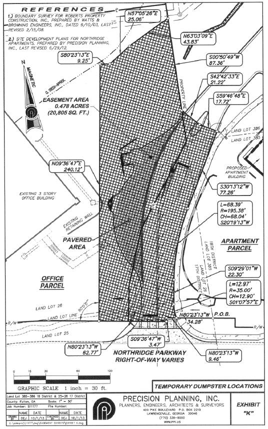
Easements. Buyer acknowledges that the Property is subject to that certain Declaration of Easements recorded in Deed Book 30621, page 508, Fulton County, Georgia records and attached hereto as Exhibit L and by this reference incorporated herein (the “Declaration”). On or before the Closing Date, the Declaration will be amended pursuant to the First Amendment to Declaration of Easements in the form attached hereto as Exhibit M and by this reference incorporated herein.
[Signatures on following page]
IN WITNESS WHEREOF, Seller and Buyer have caused this Purchase and Sale Agreement to be executed by their respective duly authorized representatives as of the day and year first above written.
|
SELLER: |
| ||
|
|
| ||
|
ROBERTS PROPERTIES RESIDENTIAL, L.P., |
| ||
|
a Georgia limited partnership |
| ||
|
|
|
| |
|
By: |
Roberts Realty Investors, Inc., |
| |
|
|
a Georgia corporation, its sole |
| |
|
|
general partner |
| |
|
|
|
| |
|
|
|
|
|
|
|
By: |
/s/ Charles S. Roberts |
|
|
|
|
Charles S. Roberts, President |
|
Notice Address:
Roberts Properties Residential, L.P.
450 Northridge Parkway
Suite 300
Atlanta, GA 30350
Attention: Charles S. Roberts
Telephone No.: (770) 394-6000
With a copy to:
Sanford H. Zatcoff, Esq.
Holt Ney Zatcoff & Wasserman, L.P.
100 Galleria Parkway, Suite 1800
Atlanta, GA 30339
Telephone No.: (770) 956-9600
[Signatures continued on following page]
|
|
|
BUYER: | |
|
|
|
| |
|
|
|
FULTON COUNTY BOARD OF EDUCATION | |
|
|
|
|
|
|
|
|
|
|
|
|
|
By: |
/s/ Linda Schulz |
|
/s/ Julie T. Baldwin |
|
|
Linda Schulz, Board President |
|
Notary Public |
|
Date: |
October 15, 2013 |
|
|
|
|
|
|
|
|
By: |
/s/ Robert M. Avossa |
|
/s/ Julie T. Baldwin |
|
|
Robert M. Avossa, Ed.D., Superintendent |
|
Notary Public |
|
Date: |
October 15, 2013 |
|
|
|
|
|
|
|
|
| |
|
|
|
Notice Address: | |
|
|
|
Fulton County Board of Education | |
|
|
|
5270 Northfield Boulevard | |
|
|
|
College Park, GA 30349 | |
|
|
|
Attention: Mr. David Knotts | |
|
|
|
Tel.:(404)669-8980 | |
|
|
|
Email: knottsd@fultoncountyschools.org | |
|
|
|
| |
|
|
|
| |
|
|
|
With a copy to: | |
|
|
|
Nelson Mullins Riley & Scarborough LLP | |
|
|
|
201 17th Street NW, Suite 1700 | |
|
|
|
Atlanta, Georgia 30363 | |
|
|
|
Attn: James E. Holmes, Jr., | |
|
|
|
Tel.: 404.322.6131 | |
|
|
|
Email: jim.holmes@nelsonmullins.com | |
Exhibit A
Legal Description of the Land
ALL THAT TRACT of land in Land Lots 25 and 26 of the 17th District, Fulton County, Georgia, described as follows:
TO FIND THE TRUE POINT OF BEGINNING, commence at a 1/2-inch rebar set at the intersection of the north right-of-way line of Northridge Parkway (right-of-way varies) with the east land lot line of said Land Lot 25; running thence along the north right-of-way line of Northridge Parkway, the following courses and distances: (1) North 80 degrees 24 minutes 01 second West 43.13 feet to a 1/2-inch rebar set, (2) South 09 degrees 35 minutes 59 seconds West 3.47 feet to a 1/2-inch rebar set, and (3) North 80 degrees 24 minutes 01 second West 34.91 feet to a 1/2-inch rebar set and the TRUE POINT OF BEGINNING; from the TRUE POINT OF BEGINNING as thus established, continuing thence along the north and northwest right-of-way line of Northridge Parkway the following courses and distances: (1) North 80 degrees 24 minutes 01 second West 68.17 feet to a 1/2-inch rebar set, (2) along the arc of a curve to the left (which arc is subtended by a chord having a bearing and distance of South 84 degrees 14 minutes 25 seconds West 204.38 feet and a radius of 385.80 feet) 206.85 feet to a 1/2-inch rebar set, (3) South 68 degrees 52 minutes 50 seconds West 113.51 feet to a 1/2-inch rebar set, (4) along the arc of a curve to the right (which arc is subtended by a chord having a bearing and distance of South 85 degrees 03 minutes 07 seconds West 109.51 feet and a radius of 196.60 feet) 110.98 feet to a 1/2-inch rebar set, and (5) North 78 degrees 46 minutes 37 seconds West 289.70 feet to a 1/2-inch rebar set; thence, leaving said right-of-way line, North 78 degrees 25 minutes 40 seconds East 292.16 feet to a 1/2-inch rebar found in the centerline of a creek; thence along the centerline of said creek and following the meanderings thereof, the following courses and distances: (1) North 37 degrees 01 minute 06 seconds East 29.15 feet to a point, (2) North 24 degrees 18 minutes 24 seconds East 30.25 feet to a point, (3) North 11 degrees 14 minutes 10 seconds East 22.92 feet to a point, (4) North 02 degrees 15 minutes 21 seconds East 24.07 feet to a point, (5) North 34 degrees 29 minutes 33 seconds East 21.75 feet to a point, (6) North 02 degrees 20 minutes 05 seconds East 22.40 feet to a point, (7) North 31 degrees 30 minutes 51 seconds East 21.50 feet to a point, (8) North 24 degrees 17 minutes 47 seconds East 30.05 feet to a point, (9) North 04 degrees 24 minutes 08 seconds East 14.52 feet to a point, (10) North 06 degrees 17 minutes 43 seconds West 25.17 feet to a point, (11) North 43 degrees 35 minutes 30 seconds East 19.80 feet to a point, and (12) North 62 degrees 42 minutes 15 seconds East 19.20 feet to a 1/2-inch rebar found in the centerline of said creek; thence, leaving said creek centerline, South 88 degrees 10 minutes 59 seconds East 464.48 feet to a 1/2-inch rebar found on the land lot line common to said Land Lot 26 and Land Lot 386 of the 18th District, Fulton County, Georgia; thence along the land lot line common to said Land Lots 26 and 386 and the land lot line common to said Land Lot 26 and Land Lot 385 of the 18th District, Fulton County, Georgia, South 00 degrees 51 minutes 16 seconds West 129.97 feet to a 1/2—inch rebar set; thence leaving said common land lot line, South 36 degrees 10 minutes 53 seconds West 92.75 feet to a 1/2-inch rebar set; thence South 21 degrees 22 minutes 22 seconds West 53.01 feet to a 1/2—inch rebar set; thence South 10 degrees 32 minutes 33 seconds West 33.22 feet to the TRUE POINT OF BEGINNING, said tract containing approximately 3.919 acres as shown on plat of ALTA/ACSM Land Title Survey for Roberts
Properties, Inc., Roberts Properties Residential, L.P., Bank of North Georgia and Commonwealth Land Title Insurance Company, prepared by Rochester & Associates, Inc., bearing the seal and certification of James C. Jones, Georgia Registered Land Surveyor No. 2298, dated March 1, 2001, last revised June 18, 2001.
LESS AND EXCEPT, that portion of the above-described property conveyed by Order and Judgment styled Department of Transportation vs. 0.047 acres of land and Roberts Properties Residential, L.P., a Georgia limited partnership, The Hellenic Tower, Inc., Northridge Atlanta, Inc., Northridge Park Owners Association, Inc., Bank of North Georgia and SouthTrust Bank under Civil Action File No. 2005 CV 98320, dated March 15, 2005, filed March 22, 2007, recorded in Deed Book 44685, page 645, aforesaid records.
TOGETHER WITH, a non-exclusive right, title and interest in and to the easements appurtenant to the above described Tract created pursuant to that certain:
(i) Amended and Restated Declaration of Reciprocal Easements among MLH Income Realty Partnership III, a New York limited partnership, Northridge 400 Associates, a Georgia general partnership, NationsBank of Georgia, N.A., formerly known as The Citizens and Southern National Bank, and Roberts Properties Highland Park, L.P., a Georgia limited partnership, dated as of August 12, 1994, filed August 19, 1994, recorded in Deed Book 18640, page 98, Fulton County, Georgia records (the “Reciprocal Easements”); as amended by First Amendment to Amended and Restated Declaration of Reciprocal Easements between MLH Income Realty Partnership III, a New York limited partnership, Northridge 400 Associates, a Georgia general partnership, Roberts Properties Residential, L.P., a Georgia limited partnership and Roberts Properties, Inc., a Georgia corporation, dated December , 1995, filed December 21, 1995, recorded in Deed Book 20394, page 302, aforesaid records and re-recorded in Deed Book 20586, page 132, filed February 5, 1996, as further amended by Second Amendment to Amended and Restated Declaration of Reciprocal Easements between Roberts Properties Residential, L.P., a Georgia limited partnership, and Gateway Mosswood, Inc., a California corporation, dated August 6, 2003, filed August 7, 2003, recorded in Deed Book 35630, page 176, aforesaid records;
(ii) Grant of Drainage Easement by and between Roberts Properties, Inc., a Georgia corporation, and Northridge Atlanta, Inc., a Delaware corporation, dated February 23, 2001, filed March 2, 2001, recorded in Deed Book 30028, page 362, aforesaid records (the “Drainage Easement”); and
(iii) Declaration of Easements by Roberts Properties Residential, L.P., a Georgia limited partnership, dated June 28, 2001, filed June 29, 2001, recorded in Deed Book 30621, page 508 aforesaid records.
Exhibit B
Rent Roll/Leases
Northridge Office Building
Rent Roll as of October 1, 2013
|
|
|
Suite |
|
SF |
|
Base |
|
Monthly |
|
Security |
|
Lease |
| |||
|
Vacant |
|
100 |
|
3,054 |
|
|
|
|
|
|
|
|
| |||
|
Greyling Insurance Brokerage |
|
101 |
|
2,092 |
|
$ |
22.19 |
|
$ |
3,868.46 |
|
$ |
3,573.83 |
|
09/30/14 |
|
|
Greyling Insurance Brokerage |
|
102 |
|
3,265 |
|
$ |
22.19 |
|
$ |
6,037.53 |
|
$ |
5,441.77 |
|
09/30/14 |
|
|
Vacant |
|
103 |
|
3,048 |
|
|
|
|
|
|
|
|
| |||
|
|
|
|
|
|
|
|
|
|
|
|
|
|
| |||
|
Vacant |
|
200 |
|
3,899 |
|
|
|
|
|
|
|
|
| |||
|
Vacant |
|
201 |
|
1,171 |
|
|
|
|
|
|
|
|
| |||
|
New South Publishing (1) |
|
202 |
|
4,450 |
|
$ |
17.00 |
|
$ |
6,304.17 |
|
$ |
— |
|
04/30/14 |
|
|
Vacant |
|
203 |
|
3,450 |
|
|
|
|
|
|
|
|
| |||
|
|
|
|
|
|
|
|
|
|
|
|
|
|
| |||
|
Roberts Properties, Inc. |
|
300 |
|
4,431 |
|
$ |
17.00 |
|
$ |
6,277.25 |
|
$ |
— |
|
12/31/13 |
|
|
Roberts Properties Construction, Inc. |
|
301 |
|
1,920 |
|
$ |
17.00 |
|
$ |
2,720.00 |
|
$ |
— |
|
12/31/13 |
|
|
Roberts Properties Residential, L.P. |
|
302 |
|
829 |
|
$ |
17.00 |
|
$ |
1,174.42 |
|
$ |
— |
|
12/31/13 |
|
|
Vacant |
|
302 |
|
6,255 |
|
|
|
|
|
|
|
|
| |||
|
|
|
|
|
|
|
|
|
|
|
|
|
|
| |||
|
Total Square Footage of Office Building |
|
|
|
37,864 |
|
|
|
|
|
$ |
9,015.60 |
|
|
| ||
Notes:
(1) Security deposit was refunded upon renewal of lease in December 2012
Exhibit C
Personalty
All personal property owned by Seller and located on the Real Property or within the Building other than Seller’s furniture, fixtures, office equipment, computers and other personal property located within Suites 300, 301, and 302 occupied by Seller and affiliates of Seller.
Exhibit D
Form of Estoppel Certificate
TENANT ESTOPPEL CERTIFICATE
The undersigned (“Tenant”) hereby certifies to , a (“Landlord”), and the Fulton County Board of Education, a political subdivision of the State of Georgia, and its successors and assigns (collectively, “Buyer”), as of the date of this estoppel certificate (“Estoppel Certificate”):
A. Tenant is the Lessee under that certain Lease dated relating to (the “Premises”), together with any amendments thereto; and a true and complete copy of the lease is attached hereto (collectively, the “Lease”).
B. The dates of all amendments to the Lease are as follows: .
C. There are no other agreements, oral or in writing, between Landlord and Tenant with respect to the Premises excepted as identified above.
D. The Lease is in full force and effect.
E. To Tenant’s knowledge, no default exists under the Lease by Landlord. All improvements required to be completed by Landlord have been completed and accepted by Tenant and there are no sums due to Tenant from Landlord and no allowances from Landlord to Tenant that have not been paid.
F. To Tenant’s knowledge, Tenant has no claim or demand against the Landlord.
G. Monthly base rent is equal to $ and has been paid through , 20 . Tenant’s proportionate share of real estate taxes, insurance, common area maintenance charges, and all other sums payable under the Lease by Tenant have been paid through the month of , 2013.
H. Tenant’s security deposit held by Landlord is $ .
I. Tenant has no right or option to purchase any portion of the real property upon which the Premises are situated.
J. Tenant has not assigned the Lease in whole or in part and has not subleased the Premises or any part thereof.
Tenant acknowledges that this Estoppel Certificate is being given in order to induce Buyer to purchase the property of which the Premises are a part, and to take on the obligations of Landlord. Buyer is entitled to rely upon this Estoppel Certificate.
Dated: , 20
|
“TENANT” |
| ||
|
|
|
|
|
|
By: |
|
|
|
|
|
|
|
|
|
|
|
|
|
|
|
(Print Name) |
(Title) |
|
Exhibit E
Form of Limited Warranty Deed
After Recording Return To:
LIMITED WARRANTY DEED
STATE OF GEORGIA
COUNTY OF
THIS INDENTURE, made this day of , 2013 between ROBERTS PROPERTIES RESIDENTIAL, L.P., a Georgia limited partnership (“Grantor”) and the FULTON COUNTY BOARD OF EDUCATION, a political subdivision of the State of Georgia (“Grantee”) (the terms “Grantor” and “Grantee” to mean and include their respective successors and assigns).
WITNESSETH: That Grantor, for and in consideration of the sum of Ten Dollars ($10.00) and other valuable consideration, the receipt and sufficiency of which are hereby acknowledged, at and before the sealing and delivery of these presents, has granted, bargained, sold and conveyed, and by these presents does grant, bargain, sell and convey unto Grantee all those certain tracts or parcels of land lying and being in Fulton County, Georgia and being more particularly described on Exhibit “A”, attached hereto and made a part hereof (collectively, the “Property”).
TO HAVE AND TO HOLD the Property, with all and singular the rights, members and appurtenances thereof, to the same being, belonging, or in anywise appertaining, to the only proper use, benefit and behoof of Grantee, forever, in fee simple.
AND Grantor will warrant and forever defend the right and title to the Property (other than any minerals thereon or therein, which are conveyed without warranty) unto Grantee against the claims of all persons owning, holding or claiming by, through or under Grantor, but against none other, subject to those matters set forth on Exhibit “B” attached hereto and made a part hereof.
IN WITNESS WHEREOF, Grantor has hereunto set its hand and seal as of the day and year above written.
|
|
|
GRANTOR: | |
|
Signed, sealed and delivered in the presence of: |
|
ROBERTS PROPERTIES RESIDENTIAL, L.P., a Georgia limited partnership | |
|
|
|
|
|
|
|
|
By: |
Roberts Realty Investors, Inc. |
|
|
|
A Georgia corporation, its sole general partner | |
|
|
|
| |
|
Unofficial Witness |
|
| |
|
|
|
|
|
|
|
|
By: |
|
|
|
|
Name: Charles S. Roberts, President | |
|
Notary Public |
|
| |
|
|
|
[corporate seal] | |
|
Commission Expiration Date: |
|
| |
|
|
|
| |
|
|
|
| |
|
[NOTARIAL SEAL] |
|
| |
Exhibit A
Property/Legal Description
ALL THAT TRACT of land in Land Lots 25 and 26 of the 17th District, Fulton County, Georgia, described as follows:
TO FIND THE TRUE POINT OF BEGINNING, commence at a 1/2-inch rebar set at the intersection of the north right-of-way line of Northridge Parkway (right-of-way varies) with the east land lot line of said Land Lot 25; running thence along the north right-of-way line of Northridge Parkway, the following courses and distances: (1) North 80 degrees 24 minutes 01 second West 43.13 feet to a 1/2-inch rebar set, (2) South 09 degrees 35 minutes 59 seconds West 3.47 feet to a 1/2-inch rebar set, and (3) North 80 degrees 24 minutes 01 second West 34.91 feet to a 1/2-inch rebar set and the TRUE POINT OF BEGINNING; from the TRUE POINT OF BEGINNING as thus established, continuing thence along the north and northwest right-of-way line of Northridge Parkway the following courses and distances: (1) North 80 degrees 24 minutes 01 second West 68.17 feet to a 1/2-inch rebar set, (2) along the arc of a curve to the left (which arc is subtended by a chord having a bearing and distance of South 84 degrees 14 minutes 25 seconds West 204.38 feet and a radius of 385.80 feet) 206.85 feet to a 1/2-inch rebar set, (3) South 68 degrees 52 minutes 50 seconds West 113.51 feet to a 1/2-inch rebar set, (4) along the arc of a curve to the right (which arc is subtended by a chord having a bearing and distance of South 85 degrees 03 minutes 07 seconds West 109.51 feet and a radius of 196.60 feet) 110.98 feet to a 1/2-inch rebar set, and (5) North 78 degrees 46 minutes 37 seconds West 289.70 feet to a 1/2-inch rebar set; thence, leaving said right-of-way line, North 78 degrees 25 minutes 40 seconds East 292.16 feet to a 1/2-inch rebar found in the centerline of a creek; thence along the centerline of said creek and following the meanderings thereof, the following courses and distances: (1) North 37 degrees 01 minute 06 seconds East 29.15 feet to a point, (2) North 24 degrees 18 minutes 24 seconds East 30.25 feet to a point, (3) North 11 degrees 14 minutes 10 seconds East 22.92 feet to a point, (4) North 02 degrees 15 minutes 21 seconds East 24.07 feet to a point, (5) North 34 degrees 29 minutes 33 seconds East 21.75 feet to a point, (6) North 02 degrees 20 minutes 05 seconds East 22.40 feet to a point, (7) North 31 degrees 30 minutes 51 seconds East 21.50 feet to a point, (8) North 24 degrees 17 minutes 47 seconds East 30.05 feet to a point, (9) North 04 degrees 24 minutes 08 seconds East 14.52 feet to a point, (10) North 06 degrees 17 minutes 43 seconds West 25.17 feet to a point, (11) North 43 degrees 35 minutes 30 seconds East 19.80 feet to a point, and (12) North 62 degrees 42 minutes 15 seconds East 19.20 feet to a 1/2-inch rebar found in the centerline of said creek; thence, leaving said creek centerline, South 88 degrees 10 minutes 59 seconds East 464.48 feet to a 1/2-inch rebar found on the land lot line common to said Land Lot 26 and Land Lot 386 of the 18th District, Fulton County, Georgia; thence along the land lot line common to said Land Lots 26 and 386 and the land lot line common to said Land Lot 26 and Land Lot 385 of the 18th District, Fulton County, Georgia, South 00 degrees 51 minutes 16 seconds West 129.97 feet to a 1/2—inch rebar set; thence leaving said common land lot line, South 36 degrees 10 minutes 53 seconds West 92.75 feet to a 1/2-inch rebar set; thence South 21 degrees 22 minutes 22 seconds West 53.01 feet to a 1/2—inch rebar set; thence South 10 degrees 32 minutes 33 seconds West 33.22 feet to the TRUE POINT OF BEGINNING, said tract containing approximately 3.919 acres as shown on plat of ALTA/ACSM Land Title Survey for Roberts Properties, Inc., Roberts Properties Residential, L.P., Bank of North Georgia and Commonwealth
Land Title Insurance Company, prepared by Rochester & Associates, Inc., bearing the seal and certification of James C. Jones, Georgia Registered Land Surveyor No. 2298, dated March 1, 2001, last revised June 18, 2001.
LESS AND EXCEPT, that portion of the above-described property conveyed by Order and Judgment styled Department of Transportation vs. 0.047 acres of land and Roberts Properties Residential, L.P., a Georgia limited partnership, The Hellenic Tower, Inc., Northridge Atlanta, Inc., Northridge Park Owners Association, Inc., Bank of North Georgia and SouthTrust Bank under Civil Action File No. 2005 CV 98320, dated March 15, 2005, filed March 22, 2007, recorded in Deed Book 44685, page 645, aforesaid records.
TOGETHER WITH, a non-exclusive right, title and interest in and to the easements appurtenant to the above described Tract created pursuant to that certain:
(i) Amended and Restated Declaration of Reciprocal Easements among MLH Income Realty Partnership III, a New York limited partnership, Northridge 400 Associates, a Georgia general partnership, NationsBank of Georgia, N.A., formerly known as The Citizens and Southern National Bank, and Roberts Properties Highland Park, L.P., a Georgia limited partnership, dated as of August 12, 1994, filed August 19, 1994, recorded in Deed Book 18640, page 98, Fulton County, Georgia records (the “Reciprocal Easements”); as amended by First Amendment to Amended and Restated Declaration of Reciprocal Easements between MLH Income Realty Partnership III, a New York limited partnership, Northridge 400 Associates, a Georgia general partnership, Roberts Properties Residential, L.P., a Georgia limited partnership and Roberts Properties, Inc., a Georgia corporation, dated December , 1995, filed December 21, 1995, recorded in Deed Book 20394, page 302, aforesaid records and re-recorded in Deed Book 20586, page 132, filed February 5, 1996; as further amended by Second Amendment to Amended and Restated Declaration of Reciprocal Easements between Roberts Properties Residential, L.P., a Georgia limited partnership, and Gateway Mosswood, Inc., a California corporation, dated August 6, 2003, filed August 7, 2003, recorded in Deed Book 35630, page 176, aforesaid records;
(ii) Grant of Drainage Easement by and between Roberts Properties, Inc., a Georgia corporation, and Northridge Atlanta, Inc., a Delaware corporation, dated February 23, 2001, filed March 2, 2001, recorded in Deed Book 30028, page 362, aforesaid records (the “Drainage Easement”); and
(iii) Declaration of Easements by Roberts Properties Residential, L.P., a Georgia limited partnership, dated June 28, 2001, filed June 29, 2001, recorded in Deed Book 30621, page 508 aforesaid records.
Exhibit B
Permitted Exceptions
1. Taxes and assessments for the year 2014 and subsequent years not yet due and payable.
2. Tree Trim Easement from Roberts Properties Residential, L.P. to Georgia Power Company dated September 20, 2006, filed October 30, 2006, and recorded in Deed Book 43774, page 647, Fulton County, Georgia records.
3. Sanitary Sewer Utility System Easement from Roberts Properties Residential, L.P. to the City of Atlanta dated April 8, 2009, filed April 19, 2009, and recorded in Deed Book 47845, page 82, Fulton County, Georgia records.
4. General Permit from John Sullivan to Southern Bell Telephone and Telegraph Company, dated March 10, 1953, filed for record February 20, 1954, and recorded in Deed Book 2073, page 256, Fulton County, Georgia records, as affected by Easement — Including Generators and Fuel Supply Systems from Roberts Properties Residential, L.P. to Bellsouth Telecommunications, Inc. dated September 17, 2001, filed October 15, 2001, and recorded in Deed Book 31144, page 7, Fulton County, Georgia records.
5. Easements contained in Dedication or Option from Mrs. Dozier Watkins and Mr. Dozier Watkins to Fulton County, dated July 14, 1964, filed for record September 28, 1964, and recorded in Deed Book 4306, page 173, aforesaid records.
6. Sewer Easement from Northridge Associates, Ltd. to Fulton County, Georgia, undated, filed for record October 25, 1984, and recorded in Deed Book 9224, page 50, aforesaid records.
7. Right of Way Easement from Northridge Associates, Ltd., a partnership, .to Southern Bell Telephone and Telegraph Company, dated January 9, 1986, filed for record January 13, 1986, and recorded in Deed Book 9917, page 396, aforesaid records.
8. Amended and Restated Declaration of Reciprocal Easements among MLH Income Realty Partnership III, a New York limited partnership, Northridge 400 Associates, a Georgia general partnership, NationsBank of Georgia, N.A., formerly known as The Citizens and Southern National Bank, and Roberts Properties Highland Park, L.P., a Georgia limited partnership, dated as of August 12, 1994, filed for record August 19, 1994, and recorded in Deed Book 18640, page 98, aforesaid records, as affected First Amendment by MLH Income Realty Partnership III, Northridge 400 Associates, Roberts Properties Residential, L.P. and Roberts Properties, Inc. dated December , 1995, filed December 21, 1995, and recorded in Deed Book 20394, page 302, Fulton County, Georgia records, and re-recorded February 5, 1996, in Deed Book 20586, page 302 and re-recorded in Deed Book 20586, page 132, filed February 5, 1996, Fulton County, Georgia records as further affected by Second Amendment to Amended and Restated Declaration of Reciprocal Easements between Roberts Properties Residential, L.P. and Gateway Mosswood, Inc. dated August 6, 2003, filed August 7, 2003, and recorded in Deed Book 35630, page 176, Fulton County, Georgia records, affecting the following:
9. Easement contained in Right of Way Deed from Roberts Properties, Inc. to Fulton County, dated June 21, 1999, filed October 7, 1999, recorded in Deed Book 27741, page 132, aforesaid records.
10. Unrecorded Easement from Northridge Associates, Ltd. to Georgia Power Company, dated November 9, 1981.
11. Obligations contained in Grant of Drainage Easement between Roberts Properties, Inc., a Georgia corporation, and Northridge Atlanta, Inc., a Delaware corporation; dated February 23, 2001, filed March 2, 2001, recorded in Deed Book 30028, page 362, aforesaid records.
12. Declaration of Easements by Roberts Properties Residential, L.P., a Georgia limited partnership, dated June 28, 2001, filed June 29, 2001, recorded in Deed Book 30621, page 508, aforesaid records.
13. Easement from G. B. Powell, agent for Ebb Rutledge, to Georgia Power .Company, dated November 3, 1937, filed for record November 22, 1937, and recorded in Deed Book 1647, page 516, aforesaid records. (affects only the Reciprocal Easements).
14. Easement from J. C. Brumbelow to Georgia Power Company, dated November 3, 1937, filed for record November 22, 1937, and recorded in Deed Book 1689, page 83A, aforesaid records. (affects only the Reciprocal Easements).
15. Easement from Mrs. Mary Bullard to Georgia Power Company, dated November 3, 1937, filed for record November 22, 1937, and recorded in Deed Book 1689, page 83B, aforesaid records. (affects only the Reciprocal Easements).
16. Right-of-Way Easement from E.D. Spruill to Georgia Power Company, dated November 15, 1957, filed December 10, 1957, recorded in Deed Book 3283 page 656, aforesaid records. (only affects the Reciprocal Easements).
17. Permit for Anchors, Guy Poles and Wires from William B. Orkin and Sanford Orkin to Georgia Power Company, dated January 14, 1972, filed for record March 16, 1972, and recorded in Deed Book 5550, page 106, aforesaid records. (affects only the Reciprocal Easements).
18. Sewer Easement from Northridge Associates, Ltd. to Fulton County, Georgia, dated September 1, 1981, filed October 19, 1981, recorded in Deed Book 7980, page 310, aforesaid records. (affects only the Reciprocal Easements).
19. Easement Agreement between General Electric Real. Estate Equities, Inc. and First Capital Institutional Real Estate, Ltd., a Florida limited partnership, dated September 28, 1983, filed September 29, 1983, recorded in Deed Book 8659, page 152, aforesaid records. (affects only the Reciprocal Easements).
20. Easement Agreement from Northridge Associates, Ltd., a Georgia limited partnership, to Northridge 400 Associates, a Georgia general partnership, and MLH Income Realty Partnership ill, a New York limited partnership, dated August 29, 1985, filed September, 1985,
recorded in Deed Book 9694, page 172, aforesaid records. (affects only the Reciprocal Easements).
21. Lease between The Oxford Group, Inc., as Lessor, and The Kroger Co., as Lessee, dated July 15, 1981, filed July 28, 1981, recorded in Deed Book 7911, page 156, aforesaid records; as amended by that certain Amended Lease between The Oxford Group, Inc., as Lessor, and The Kroger Co., as Lessee, undated, filed February 4, 1983, recorded in Deed Book 8368, page 436, aforesaid records; as further amended by that certain Second Amended Lease between First Capital Institutional Real Estate, Ltd,-J, as Lessor, and The Kroger Co., as Lessee, dated as of January 3, 1984, filed January 18, 1984, recorded in Deed Book 8812, page 497, aforesaid records; as further amended by that certain Lease Modification Agreement #2 between First Capital Institutional Real Estate, Ltd.-I, as Lessor, and The Kroger Co., as Lessee, dated November 21, 1983 and January 3, 1984, filed March 2, 1984, recorded in Deed Book 8869, page 327, aforesaid records (only affects the Drainage Easement).
22. Declaration of Restrictions and Cross Easement Agreement between Northridge Associates and First Capital Institutional Real Estate, Ltd., dated as of September 29, 1983, filed September 29, 1983, recorded in Deed Book 8659, page 143, aforesaid records (only affects the Drainage Easement).
23. Slope Easement Agreement by First Capital Institutional Real Estate, Ltd.-l in favor of Pointe North Limited, dated as of November 14, 1984, filed December 5, 1984, recorded in Deed Book 9282, page 224, aforesaid records (only affects the Drainage Easement).
24. Easement from Northridge Atlanta, Inc. to Georgia Power Company, dated December 30, 1996, filed May 14, 1997, recorded in Deed Book 22596, page 167, aforesaid records (only affects tile Drainage Easement).
25. Rights of upper and lower riparian owners in and to the waters of rivers, creeks or branches, crossing or adjoining the property encumbered by the easements insured hereunder, and the natural flow thereof, free from diminution or pollution.
26. Any adverse claim based upon the assertion that (a) some portion of the subject property has been created by artificial means, or has accreted to such portion so created; or (b) some portion of the subject property has been brought within the boundaries thereof by an avulsive movement of the creek forming a portion of the northwestern boundary line of the subject property, or has been formed by accretion to any such portion.
27. All matters disclosed by plat of ALTA/ACSM Land Title Survey for Roberts Properties, Inc., Roberts Properties Residential, L.P., Bank of North Georgia and Commonwealth Land Title Insurance Company by Rochester & Associates, bearing the seal and certification of James C. Jones, Georgia Registered Land Surveyor No. 2298, dated March 1, 2001, last revised June 18, 2001, and such state of facts occurring after June 18, 2001 which would be disclosed by a current, accurate survey and inspection of the real property herein described.
28. Easement from Roberts Properties Residential, L.P. to Georgia Power Company, dated November 20, 2002, filed May 16, 2003, recorded in Deed Book 34963, page 358, aforesaid records.
29. Easement rights contained in that certain Order and Judgment styled Department of Transportation vs. 0.047 acres of land and Roberts Properties Residential, L.P., a Georgia limited partnership, The Hellenic Tower, Inc., Northridge Atlanta, Inc., Northridge Park Owners Association, Inc., Bank of North Georgia and SouthTrust Bank under Civil Action File No. 2005 CV 98320, dated March 15, 2005, filed March 22, 2007, recorded in Deed Book 44685, page 645, aforesaid records.
30. Easements, encroachments, overlaps, boundary line disputes or any other matters that would be disclosed by a current, accurate survey and inspection of the property encumbered by the appurtenant easements (affects only the appurtenant easements).
31. Rights of tenants in possession of the property encumbered by the appurtenant easements under unrecorded leases (affects only the appurtenant easements).
32. Rights of tenants in possession of individual office spaces, as tenants only.
Exhibit F
Form of Bill of Sale
BILL OF SALE
THIS BILL OF SALE is executed as of the day of , 2013 by ROBERTS PROPERTIES RESIDENTIAL, L.P., a Georgia limited partnership (“Seller”) and FULTON COUNTY BOARD OF EDUCATION, a political subdivision of the State of Georgia (“Purchaser”).
W I T N E S S E T H:
WHEREAS, contemporaneously herewith, Seller has transferred and conveyed to Purchaser certain real property in Fulton County, Georgia and improvements thereon, such real property being described on Exhibit “A” attached hereto and made a part hereof (the “Property”); and
WHEREAS, in connection with the transfer of the Property by Seller to Purchaser, Seller has also agreed to transfer to Purchaser certain personal property located on the Property;
NOW, THEREFORE, for and in consideration of TEN AND NO/100 ($10.00) DOLLARS and other good and valuable consideration, the receipt, adequacy, and sufficiency of which are hereby acknowledged, Seller has GRANTED, QUITCLAIMED, CONVEYED, SOLD, TRANSFERRED, SET-OVER, and DELIVERED, and by these presents does hereby GRANT, QUITCLAIM, CONVEY, SELL, TRANSFER, SET-OVER, and DELIVER unto Purchaser, any and all fixtures, equipment, machinery, building materials, furniture, appliances, and other items of personal property owned by Seller and located on the Property (the “Personal Property”) all and singular, the Personal Property unto Purchaser forever, except for those certain fixtures, equipment, machinery, building materials, furniture, appliances, and other items of personal property owned by Seller, located on the Property, and listed on Exhibit “B” attached hereto and made a part hereof (the “Excluded Property”). The Personal Property is conveyed on an “as is, where is” basis, without any representation or warranty whatsoever.
This Bill of Sale and the provisions herein contained shall be binding upon and inure to the benefit of Seller and Purchaser and their respective successors and assigns.
[SIGNATURES APPEAR ON FOLLOWING PAGE.]
[SIGNATURE PAGE TO BILL OF SALE]
EXECUTED as of the day and year first written above.
|
|
SELLER: | |
|
|
| |
|
|
| |
|
|
ROBERTS PROPERTIES RESIDENTIAL, L.P., a Georgia limited partnership | |
|
|
|
|
|
|
By: |
Roberts Realty Investors, Inc. |
|
|
A Georgia corporation, its sole general partner | |
|
|
| |
|
|
|
|
|
|
By: |
|
|
|
Name: Charles S. Roberts, President | |
|
|
| |
|
|
[corporate seal] | |
Exhibit A
Legal Description of the Property
ALL THAT TRACT of land in Land Lots 25 and 26 of the 17th District, Fulton County, Georgia, described as follows:
TO FIND THE TRUE POINT OF BEGINNING, commence at a 1/2-inch rebar set at the intersection of the north right-of-way line of Northridge Parkway (right-of-way varies) with the east land lot line of said Land Lot 25; running thence along the north right-of-way line of Northridge Parkway, the following courses and distances: (1) North 80 degrees 24 minutes 01 second West 43.13 feet to a 1/2-inch rebar set, (2) South 09 degrees 35 minutes 59 seconds West 3.47 feet to a 1/2-inch rebar set, and (3) North 80 degrees 24 minutes 01 second West 34.91 feet to a 1/2-inch rebar set and the TRUE POINT OF BEGINNING; from the TRUE POINT OF BEGINNING as thus established, continuing thence along the north and northwest right-of-way line of Northridge Parkway the following courses and distances: (1) North 80 degrees 24 minutes 01 second West 68.17 feet to a 1/2-inch rebar set, (2) along the arc of a curve to the left (which arc is subtended by a chord having a bearing and distance of South 84 degrees 14 minutes 25 seconds West 204.38 feet and a radius of 385.80 feet) 206.85 feet to a 1/2-inch rebar set, (3) South 68 degrees 52 minutes 50 seconds West 113.51 feet to a 1/2-inch rebar set, (4) along the arc of a curve to the right (which arc is subtended by a chord having a bearing and distance of South 85 degrees 03 minutes 07 seconds West 109.51 feet and a radius of 196.60 feet) 110.98 feet to a 1/2-inch rebar set, and (5) North 78 degrees 46 minutes 37 seconds West 289.70 feet to a 1/2-inch rebar set; thence, leaving said right-of-way line, North 78 degrees 25 minutes 40 seconds East 292.16 feet to a 1/2-inch rebar found in the centerline of a creek; thence along the centerline of said creek and following the meanderings thereof, the following courses and distances: (1) North 37 degrees 01 minute 06 seconds East 29.15 feet to a point, (2) North 24 degrees 18 minutes 24 seconds East 30.25 feet to a point, (3) North 11 degrees 14 minutes 10 seconds East 22.92 feet to a point, (4) North 02 degrees 15 minutes 21 seconds East 24.07 feet to a point, (5) North 34 degrees 29 minutes 33 seconds East 21.75 feet to a point, (6) North 02 degrees 20 minutes 05 seconds East 22.40 feet to a point, (7) North 31 degrees 30 minutes 51 seconds East 21.50 feet to a point, (8) North 24 degrees 17 minutes 47 seconds East 30.05 feet to a point, (9) North 04 degrees 24 minutes 08 seconds East 14.52 feet to a point, (10) North 06 degrees 17 minutes 43 seconds West 25.17 feet to a point, (11) North 43 degrees 35 minutes 30 seconds East 19.80 feet to a point, and (12) North 62 degrees 42 minutes 15 seconds East 19.20 feet to a 1/2-inch rebar found in the centerline of said creek; thence, leaving said creek centerline, South 88 degrees 10 minutes 59 seconds East 464.48 feet to a 1/2-inch rebar found on the land lot line common to said Land Lot 26 and Land Lot 386 of the 18th District, Fulton County, Georgia; thence along the land lot line common to said Land Lots 26 and 386 and the land lot line common to said Land Lot 26 and Land Lot 385 of the 18th District, Fulton County, Georgia, South 00 degrees 51 minutes 16 seconds West 129.97 feet to a 1/2—inch rebar set; thence leaving said common land lot line, South 36 degrees 10 minutes 53 seconds West 92.75 feet to a 1/2-inch rebar set; thence South 21 degrees 22 minutes 22 seconds West 53.01 feet to a 1/2—inch rebar set; thence South 10 degrees 32 minutes 33 seconds West 33.22 feet to the TRUE POINT OF BEGINNING, said tract containing approximately 3.919 acres as shown on plat of ALTA/ACSM Land Title Survey for Roberts Properties, Inc., Roberts Properties Residential, L.P., Bank of North Georgia and Commonwealth Land Title Insurance Company, prepared by Rochester & Associates, Inc., bearing the seal and
certification of James C. Jones, Georgia Registered Land Surveyor No. 2298, dated March 1, 2001, last revised June 18, 2001.
LESS AND EXCEPT, that portion of the above-described property conveyed by Order and Judgment styled Department of Transportation vs. 0.047 acres of land and Roberts Properties Residential, L.P., a Georgia limited partnership, The Hellenic Tower, Inc., Northridge Atlanta, Inc., Northridge Park Owners Association, Inc., Bank of North Georgia and SouthTrust Bank under Civil Action File No. 2005 CV 98320, dated March 15, 2005, filed March 22, 2007, recorded in Deed Book 44685, page 645, aforesaid records.
TOGETHER WITH, a non-exclusive right, title and interest in and to the easements appurtenant to the above described Tract created pursuant to that certain:
(i) Amended and Restated Declaration of Reciprocal Easements among MLH Income Realty Partnership III, a New York limited partnership, Northridge 400 Associates, a Georgia general partnership, NationsBank of Georgia, N.A., formerly known as The Citizens and Southern National Bank, and Roberts Properties Highland Park, L.P., a Georgia limited partnership, dated as of August 12, 1994, filed August 19, 1994, recorded in Deed Book 18640, page 98, Fulton County, Georgia records (the “Reciprocal Easements”); as amended by First Amendment to Amended and Restated Declaration of Reciprocal Easements between MLH Income Realty Partnership III, a New York limited partnership, Northridge 400 Associates, a Georgia general partnership, Roberts Properties Residential, L.P., a Georgia limited partnership and Roberts Properties, Inc., a Georgia corporation, dated December , 1995, filed December 21, 1995, recorded in Deed Book 20394, page 302, aforesaid records and re-recorded in Deed Book 20586, page 132, filed February 5, 1996; as further amended by Second Amendment to Amended and Restated Declaration of Reciprocal Easements between Roberts Properties Residential, L.P., a Georgia limited partnership, and Gateway Mosswood, Inc., a California corporation, dated August 6, 2003, filed August 7, 2003, recorded in Deed Book 35630, page 176, aforesaid records;
(ii) Grant of Drainage Easement by and between Roberts Properties, Inc., a Georgia corporation, and Northridge Atlanta, Inc., a Delaware corporation, dated February 23, 2001, filed March 2, 2001, recorded in Deed Book 30028, page 362, aforesaid records (the “Drainage Easement”); and
(iii) Declaration of Easements by Roberts Properties Residential, L.P., a Georgia limited partnership, dated June 28, 2001, filed June 29, 2001, recorded in Deed Book 30621, page 508 aforesaid records.
Exhibit B
List of Excluded Property
Seller’s furniture, fixtures, office equipment, computers and other personal property located within Suites 300, 301, and 302 occupied by Seller and affiliates of Seller.
Exhibit G
Form of Assignment of Leases
ASSIGNMENT OF LEASES
This Assignment of Leases (this “Assignment”) is executed and delivered as of the day of , 2013 (the “Closing Date”) pursuant to that certain Purchase and Sale Agreement (“Agreement”) dated , 2013, by and between ROBERTS PROPERTIES RESIDENTIAL, L.P., a Georgia limited partnership (“Seller”), and FULTON COUNTY BOARD OF EDUCATION, a political subdivision of the State of Georgia (“Buyer”), covering the real property described in Exhibit A attached hereto (“Property”).
1. Assignment of Leases . For good and valuable consideration, Seller hereby assigns, transfers, sets over and conveys to Buyer, and Buyer hereby accepts the following:
(a) Leases. All of the Seller’s right, title and interest in and to all tenant leases listed in Schedule 1 attached hereto (“Leases”);
2. Assumption. Buyer hereby assumes the obligations of Seller under the Leases arising on after the Closing Date. Seller remains solely responsible for Seller’s obligations under the Lease prior to the Closing Date. Buyer agrees to hold and disburse the security deposits turned over by Seller to Buyer on the Closing Date in accordance with the Leases and applicable Georgia law.
3. Agreement Applies. Except as may otherwise be provided in the Agreement, the Leases are being assigned and transferred to Buyer on an “as is,” and “where is” basis.
4. Counterparts. This Assignment may be executed in two (2) or more counterparts, each of which shall be deemed an original, but all of which together shall constitute one and the same instrument, with the same effect as if all parties had signed the same signature page.
5. Miscellaneous. This Assignment shall be binding upon and shall inure to the benefit of the parties hereto, their heirs, executors, administrators, successor-in-interest and assigns. If any term or provision of this Assignment shall be held invalid or unenforceable, the remainder of this Assignment shall not be affected. This Assignment shall be construed in accordance with and governed by the laws of the State of Georgia. Nothing in this Assignment shall impair, limit or lessen any of the rights of the parties with respect to the provisions of the Agreement which were intended to survive the Closing Date. Nothing in this Assignment, express or implied, is intended to confer upon any person or entity, other than the parties hereto and their respective successors and assigns, any rights or remedies.
IN WITNESS WHEREOF, the undersigned have caused this instrument to be executed as of the date written above.
SELLER:
ROBERTS PROPERTIES RESIDENTIAL, L.P., a Georgia limited partnership
|
By: |
Roberts Realty Investors, Inc. |
|
| ||
|
A Georgia corporation, its sole general partner |
|
| |||
|
|
|
| |||
|
|
|
|
| ||
|
By: |
|
|
| ||
|
Name: Charles S. Roberts, President |
|
| |||
|
|
|
| |||
|
|
|
BUYER: | |||
|
|
|
| |||
|
|
|
FULTON COUNTY BOARD OF EDUCATION | |||
|
|
|
| |||
|
|
|
|
| ||
|
|
|
By: |
| ||
|
|
|
|
Linda Schultz, Board President | ||
|
|
|
| |||
|
|
|
|
| ||
|
|
By: |
|
|
| |
|
|
Robert M. Avossa, Ed.D., Superintendent |
|
| ||
Leases and Rent Roll
1) [Greyling Insurance Brokerage & Risk Consulting, Inc.]
2) [New South Publishing, Inc.]
3) [Roberts Properties, Inc.]
4) [Roberts Properties Construction, Inc.]
[Attach updated rent roll
Exhibit H
Form of Assignment of Intangible Property
ASSIGNMENT OF INTANGIBLE PROPERTY
THIS ASSIGNMENT OF INTANGIBLE PROPERTY (this “Assignment”) is made as of the day of October, 2013 (the “Effective Date”), by ROBERTS PROPERTIES RESIDENTIAL, L.P., a Georgia limited partnership (“Assignor”), and given unto the FULTON COUNTY BOARD OF EDUCATION, a political subdivision of the State of Georgia (“Assignee”).
W I T N E S S E T H :
WHEREAS, Assignor, as seller, and Assignee, as buyer, have entered into that certain Purchase and Sale Agreement dated , 2013 (the “Purchase Agreement”), wherein Assignor agreed to sell and Assignee agreed to buy that certain tract or parcel of land described in Exhibit A attached hereto, together with together with all improvements, structures, fixtures and parking areas located thereon (collectively, the “Real Property”); and
WHEREAS, in connection with and pursuant to the Purchase Agreement, Assignor desires to assign its right, title and interest in and to certain rights, interests and property inuring to the benefit of Assignor and relating to the Real Property.
NOW, THEREFORE, in consideration of the sum of TEN AND NO/100 DOLLARS ($10.00) in hand paid, and other good and valuable consideration, the receipt and sufficiency of which are hereby acknowledged, Assignor hereby assigns, transfers, sets over, and conveys to Assignee, to the extent the same are assignable, all of Assignor’s right, title, and interest, if any, in and to all intangible rights and property used or useful in connection with the Real Property, including, without limitation, all development rights, zoning approvals, contract rights, licenses, plans, drawings, permits and warranties.
This Assignment shall be binding upon Assignor and shall inure to the benefit of Assignee and their respective successors and assigns. This Assignment shall be governed by and construed under the laws of the State of Georgia. Assignee shall be authorized to accept, and may rely upon, an electronic transmission of this Assignment (e.g., by facsimile or email) executed by Assignor and such document shall be binding upon Assignor.
[Signature on following page]
IN WITNESS WHEREOF, Assignor has executed this Assignment of Intangible Property under seal as of the Effective Date.
|
|
ASSIGNOR: | |
|
|
| |
|
|
ROBERTS PROPERTIES RESIDENTIAL, L.P., a Georgia limited partnership | |
|
|
|
|
|
|
By: |
Roberts Realty Investors, Inc. |
|
|
A Georgia corporation, its sole general partner | |
|
|
| |
|
|
|
|
|
|
By: |
|
|
|
Name: Charles S. Roberts, President | |
|
|
| |
|
|
[corporate seal] | |
Exhibit A
Property/Legal Description
ALL THAT TRACT of land in Land Lots 25 and 26 of the 17th District, Fulton County, Georgia, described as follows:
TO FIND THE TRUE POINT OF BEGINNING, commence at a 1/2-inch rebar set at the intersection of the north right-of-way line of Northridge Parkway (right-of-way varies) with the east land lot line of said Land Lot 25; running thence along the north right-of-way line of Northridge Parkway, the following courses and distances: (1) North 80 degrees 24 minutes 01 second West 43.13 feet to a 1/2-inch rebar set, (2) South 09 degrees 35 minutes 59 seconds West 3.47 feet to a 1/2-inch rebar set, and (3) North 80 degrees 24 minutes 01 second West 34.91 feet to a 1/2-inch rebar set and the TRUE POINT OF BEGINNING; from the TRUE POINT OF BEGINNING as thus established, continuing thence along the north and northwest right-of-way line of Northridge Parkway the following courses and distances: (1) North 80 degrees 24 minutes 01 second West 68.17 feet to a 1/2-inch rebar set, (2) along the arc of a curve to the left (which arc is subtended by a chord having a bearing and distance of South 84 degrees 14 minutes 25 seconds West 204.38 feet and a radius of 385.80 feet) 206.85 feet to a 1/2-inch rebar set, (3) South 68 degrees 52 minutes 50 seconds West 113.51 feet to a 1/2-inch rebar set, (4) along the arc of a curve to the right (which arc is subtended by a chord having a bearing and distance of South 85 degrees 03 minutes 07 seconds West 109.51 feet and a radius of 196.60 feet) 110.98 feet to a 1/2-inch rebar set, and (5) North 78 degrees 46 minutes 37 seconds West 289.70 feet to a 1/2-inch rebar set; thence, leaving said right-of-way line, North 78 degrees 25 minutes 40 seconds East 292.16 feet to a 1/2-inch rebar found in the centerline of a creek; thence along the centerline of said creek and following the meanderings thereof, the following courses and distances: (1) North 37 degrees 01 minute 06 seconds East 29.15 feet to a point, (2) North 24 degrees 18 minutes 24 seconds East 30.25 feet to a point, (3) North 11 degrees 14 minutes 10 seconds East 22.92 feet to a point, (4) North 02 degrees 15 minutes 21 seconds East 24.07 feet to a point, (5) North 34 degrees 29 minutes 33 seconds East 21.75 feet to a point, (6) North 02 degrees 20 minutes 05 seconds East 22.40 feet to a point, (7) North 31 degrees 30 minutes 51 seconds East 21.50 feet to a point, (8) North 24 degrees 17 minutes 47 seconds East 30.05 feet to a point, (9) North 04 degrees 24 minutes 08 seconds East 14.52 feet to a point, (10) North 06 degrees 17 minutes 43 seconds West 25.17 feet to a point, (11) North 43 degrees 35 minutes 30 seconds East 19.80 feet to a point, and (12) North 62 degrees 42 minutes 15 seconds East 19.20 feet to a 1/2-inch rebar found in the centerline of said creek; thence, leaving said creek centerline, South 88 degrees 10 minutes 59 seconds East 464.48 feet to a 1/2-inch rebar found on the land lot line common to said Land Lot 26 and Land Lot 386 of the 18th District, Fulton County, Georgia; thence along the land lot line common to said Land Lots 26 and 386 and the land lot line common to said Land Lot 26 and Land Lot 385 of the 18th District, Fulton County, Georgia, South 00 degrees 51 minutes 16 seconds West 129.97 feet to a 1/2—inch rebar set; thence leaving said common land lot line, South 36 degrees 10 minutes 53 seconds West 92.75 feet to a 1/2-inch rebar set; thence South 21 degrees 22 minutes 22 seconds West 53.01 feet to a 1/2—inch rebar set; thence South 10 degrees 32
minutes 33 seconds West 33.22 feet to the TRUE POINT OF BEGINNING, said tract containing approximately 3.919 acres as shown on plat of ALTA/ACSM Land Title Survey for Roberts Properties, Inc., Roberts Properties Residential, L.P., Bank of North Georgia and Commonwealth Land Title Insurance Company, prepared by Rochester & Associates, Inc., bearing the seal and certification of James C. Jones, Georgia Registered Land Surveyor No. 2298, dated March 1, 2001, last revised June 18, 2001.
LESS AND EXCEPT, that portion of the above-described property conveyed by Order and Judgment styled Department of Transportation vs. 0.047 acres of land and Roberts Properties Residential, L.P., a Georgia limited partnership, The Hellenic Tower, Inc., Northridge Atlanta, Inc., Northridge Park Owners Association, Inc., Bank of North Georgia and SouthTrust Bank under Civil Action File No. 2005 CV 98320, dated March 15, 2005, filed March 22, 2007, recorded in Deed Book 44685, page 645, aforesaid records.
TOGETHER WITH, a non-exclusive right, title and interest in and to the easements appurtenant to the above described Tract created pursuant to that certain:
(i) Amended and Restated Declaration of Reciprocal Easements among MLH Income Realty Partnership III, a New York limited partnership, Northridge 400 Associates, a Georgia general partnership, NationsBank of Georgia, N.A., formerly known as The Citizens and Southern National Bank, and Roberts Properties Highland Park, L.P., a Georgia limited partnership, dated as of August 12, 1994, filed August 19, 1994, recorded in Deed Book 18640, page 98, Fulton County, Georgia records (the “Reciprocal Easements”); as amended by First Amendment to Amended and Restated Declaration of Reciprocal Easements between MLH Income Realty Partnership III, a New York limited partnership, Northridge 400 Associates, a Georgia general partnership, Roberts Properties Residential, L.P., a Georgia limited partnership and Roberts Properties, Inc., a Georgia corporation, dated December , 1995, filed December 21, 1995, recorded in Deed Book 20394, page 302, aforesaid records and re-recorded in Deed Book 20586, page 132, filed February 5, 1996; as further amended by Second Amendment to Amended and Restated Declaration of Reciprocal Easements between Roberts Properties Residential, L.P., a Georgia limited partnership, and Gateway Mosswood, Inc., a California corporation, dated August 6, 2003, filed August 7, 2003, recorded in Deed Book 35630, page 176, aforesaid records;
(ii) Grant of Drainage Easement by and between Roberts Properties, Inc., a Georgia corporation, and Northridge Atlanta, Inc., a Delaware corporation, dated February 23, 2001, filed March 2, 2001, recorded in Deed Book 30028, page 362, aforesaid records (the “Drainage Easement”); and
(iii) Declaration of Easements by Roberts Properties Residential, L.P., a Georgia limited partnership, dated June 28, 2001, filed June 29, 2001, recorded in Deed Book 30621, page 508 aforesaid records.
Exhibit I
Form of Title Affidavit
SELLER’S AFFIDAVIT
STATE OF GEORGIA
COUNTY OF COBB
Personally appeared before me the undersigned officer, Charles S. Roberts (“Deponent”), who, being duly sworn according to law, deposes and says on oath as follows, to the best of Deponent’s actual knowledge without inquiry:
1. That Deponent is the President of Roberts Realty Investors, Inc., a Georgia corporation (the “Corporation”), which is the sole general partner of ROBERTS PROPERTIES RESIDENTIAL, L.P., a Georgia limited partnership (the “Owner”), and as such, has personal knowledge of the facts sworn to in this Affidavit.
2. That the Owner is the owner of certain real estate (the “Property”), a description of which is attached hereto as Exhibit A and made a part hereof.
3. That the Owner is in open, exclusive, notorious, continuous, adverse and peaceable possession of the Property and that the title thereto has never been disputed, questioned or rejected or title insurance thereon refused, and Deponent knows of no one claiming any adverse interest in the Property whatsoever.
4. That the Owner is in full force and effect and no proceeding is pending for its dissolution or annulment. That the Articles of Incorporation of the Corporation are in full force and effect and no proceeding is pending for its dissolution or annulment. All licenses and franchise taxes due and payable by either the Owner or the Corporation have been paid in full.
5. That the lines and corners of the Property are clearly marked and there are no disputes concerning the location of the lines and corners.
6. That no improvements or repairs have been made to the Property by or at the instance of the Owner or the Corporation during the one-hundred (100) days immediately preceding the date hereof and there are no outstanding bills incurred by or at the instance of the Owner or the Corporation for labor and materials used in making improvements or repairs on the Property or for services of architects, surveyors or engineers; or if any such work, improvements or repairs have been made by or at the instance of the Owner or the Corporation within the last one-hundred (100) days, the work, improvements and repairs are complete and there are no unpaid bills of any nature incurred by or at the instance of the Owner or the Corporation either for services of any architect,
engineer or surveyor or for labor or materials for any recent improvements that may have been placed upon the Property in either the construction or repair of any improvements thereon, except for bills which will be paid in the ordinary course of business.
7. That there are no pending suits, judgments, bankruptcies, executions, liens for past due taxes, assessments, encumbrances or leases that could in any way affect the title to the Property, or constitute a lien thereon, except as set forth on Exhibit B attached hereto and made a part hereof, and the Owner is not surety on the bond of any county official or any other bond that through default of the principal therein a lien could be created superior to any conveyance executed by the Owner.
8. That there are no liens for past due taxes of any nature or any unpaid assessments for paving, sidewalks, curbing, sewer or any other street improvements of any kind against the Property or the Owner.
9. That except for CBRE, Inc., no real estate broker’s services have been engaged by Owner or the Corporation in connection with the management, sale, purchase, lease, option or other conveyance of any interest in the Property, and that no notice of lien for any such services has been received.
This affidavit is made to induce Fulton County Board of Education to purchase the Property, the attorney certifying title to so certify and Metropolitan Title Agency, Inc. and Commonwealth Land Title Insurance Company to issue an owner’s title insurance policy with respect to the Property, provided that Deponent shall have no personal liability under this Affidavit except in the case of intentional lying.
|
|
|
(SEAL) |
|
|
Charles S. Roberts |
|
|
|
| |
|
Sworn to and subscribed before me this day of October, 2013. |
| |
|
|
| |
|
|
| |
|
Notary Public |
| |
|
|
|
|
|
|
(NOTARY SEAL) |
|
Exhibit A
Property/Legal Description
ALL THAT TRACT of land in Land Lots 25 and 26 of the 17th District, Fulton County, Georgia, described as follows:
TO FIND THE TRUE POINT OF BEGINNING, commence at a 1/2-inch rebar set at the intersection of the north right-of-way line of Northridge Parkway (right-of-way varies) with the east land lot line of said Land Lot 25; running thence along the north right-of-way line of Northridge Parkway, the following courses and distances: (1) North 80 degrees 24 minutes 01 second West 43.13 feet to a 1/2-inch rebar set, (2) South 09 degrees 35 minutes 59 seconds West 3.47 feet to a 1/2-inch rebar set, and (3) North 80 degrees 24 minutes 01 second West 34.91 feet to a 1/2-inch rebar set and the TRUE POINT OF BEGINNING; from the TRUE POINT OF BEGINNING as thus established, continuing thence along the north and northwest right-of-way line of Northridge Parkway the following courses and distances: (1) North 80 degrees 24 minutes 01 second West 68.17 feet to a 1/2-inch rebar set, (2) along the arc of a curve to the left (which arc is subtended by a chord having a bearing and distance of South 84 degrees 14 minutes 25 seconds West 204.38 feet and a radius of 385.80 feet) 206.85 feet to a 1/2-inch rebar set, (3) South 68 degrees 52 minutes 50 seconds West 113.51 feet to a 1/2-inch rebar set, (4) along the arc of a curve to the right (which arc is subtended by a chord having a bearing and distance of South 85 degrees 03 minutes 07 seconds West 109.51 feet and a radius of 196.60 feet) 110.98 feet to a 1/2-inch rebar set, and (5) North 78 degrees 46 minutes 37 seconds West 289.70 feet to a 1/2-inch rebar set; thence, leaving said right-of-way line, North 78 degrees 25 minutes 40 seconds East 292.16 feet to a 1/2-inch rebar found in the centerline of a creek; thence along the centerline of said creek and following the meanderings thereof, the following courses and distances: (1) North 37 degrees 01 minute 06 seconds East 29.15 feet to a point, (2) North 24 degrees 18 minutes 24 seconds East 30.25 feet to a point, (3) North 11 degrees 14 minutes 10 seconds East 22.92 feet to a point, (4) North 02 degrees 15 minutes 21 seconds East 24.07 feet to a point, (5) North 34 degrees 29 minutes 33 seconds East 21.75 feet to a point, (6) North 02 degrees 20 minutes 05 seconds East 22.40 feet to a point, (7) North 31 degrees 30 minutes 51 seconds East 21.50 feet to a point, (8) North 24 degrees 17 minutes 47 seconds East 30.05 feet to a point, (9) North 04 degrees 24 minutes 08 seconds East 14.52 feet to a point, (10) North 06 degrees 17 minutes 43 seconds West 25.17 feet to a point, (11) North 43 degrees 35 minutes 30 seconds East 19.80 feet to a point, and (12) North 62 degrees 42 minutes 15 seconds East 19.20 feet to a 1/2-inch rebar found in the centerline of said creek; thence, leaving said creek centerline, South 88 degrees 10 minutes 59 seconds East 464.48 feet to a 1/2-inch rebar found on the land lot line common to said Land Lot 26 and Land Lot 386 of the 18th District, Fulton County, Georgia; thence along the land lot line common to said Land Lots 26 and 386 and the land lot line common to said Land Lot 26 and Land Lot 385 of the 18th District, Fulton County, Georgia, South 00 degrees 51 minutes 16 seconds West 129.97 feet to a 1/2—inch rebar set; thence leaving said common land lot line, South 36 degrees 10 minutes 53 seconds West 92.75 feet to a 1/2-inch rebar set; thence South 21 degrees 22 minutes 22 seconds West 53.01 feet to a 1/2—inch rebar set; thence South 10 degrees 32
minutes 33 seconds West 33.22 feet to the TRUE POINT OF BEGINNING, said tract containing approximately 3.919 acres as shown on plat of ALTA/ACSM Land Title Survey for Roberts Properties, Inc., Roberts Properties Residential, L.P., Bank of North Georgia and Commonwealth Land Title Insurance Company, prepared by Rochester & Associates, Inc., bearing the seal and certification of James C. Jones, Georgia Registered Land Surveyor No. 2298, dated March 1, 2001, last revised June 18, 2001.
LESS AND EXCEPT, that portion of the above-described property conveyed by Order and Judgment styled Department of Transportation vs. 0.047 acres of land and Roberts Properties Residential, L.P., a Georgia limited partnership, The Hellenic Tower, Inc., Northridge Atlanta, Inc., Northridge Park Owners Association, Inc., Bank of North Georgia and SouthTrust Bank under Civil Action File No. 2005 CV 98320, dated March 15, 2005, filed March 22, 2007, recorded in Deed Book 44685, page 645, aforesaid records.
TOGETHER WITH, a non-exclusive right, title and interest in and to the easements appurtenant to the above described Tract created pursuant to that certain:
(i) Amended and Restated Declaration of Reciprocal Easements among MLH Income Realty Partnership III, a New York limited partnership, Northridge 400 Associates, a Georgia general partnership, NationsBank of Georgia, N.A., formerly known as The Citizens and Southern National Bank, and Roberts Properties Highland Park, L.P., a Georgia limited partnership, dated as of August 12, 1994, filed August 19, 1994, recorded in Deed Book 18640, page 98, Fulton County, Georgia records (the “Reciprocal Easements”); as amended by First Amendment to Amended and Restated Declaration of Reciprocal Easements between MLH Income Realty Partnership III, a New York limited partnership, Northridge 400 Associates, a Georgia general partnership, Roberts Properties Residential, L.P., a Georgia limited partnership and Roberts Properties, Inc., a Georgia corporation, dated December , 1995, filed December 21, 1995, recorded in Deed Book 20394, page 302, aforesaid records and re-recorded in Deed Book 20586, page 132, filed February 5, 1996; as further amended by Second Amendment to Amended and Restated Declaration of Reciprocal Easements between Roberts Properties Residential, L.P., a Georgia limited partnership, and Gateway Mosswood, Inc., a California corporation, dated August 6, 2003, filed August 7, 2003, recorded in Deed Book 35630, page 176, aforesaid records;
(ii) Grant of Drainage Easement by and between Roberts Properties, Inc., a Georgia corporation, and Northridge Atlanta, Inc., a Delaware corporation, dated February 23, 2001, filed March 2, 2001, recorded in Deed Book 30028, page 362, aforesaid records (the “Drainage Easement”); and
(iii) Declaration of Easements by Roberts Properties Residential, L.P., a Georgia limited partnership, dated June 28, 2001, filed June 29, 2001, recorded in Deed Book 30621, page 508 aforesaid records.
Permitted Exceptions
1. Taxes and assessments for the year 2014 and subsequent years not yet due and payable.
2. Tree Trim Easement from Roberts Properties Residential, L.P. to Georgia Power Company dated September 20, 2006, filed October 30, 2006, and recorded in Deed Book 43774, page 647, Fulton County, Georgia records.
3. Sanitary Sewer Utility System Easement from Roberts Properties Residential, L.P. to the City of Atlanta dated April 8, 2009, filed April 19, 2009, and recorded in Deed Book 47845, page 82, Fulton County, Georgia records.
4. General Permit from John Sullivan to Southern Bell Telephone and Telegraph Company, dated March 10, 1953, filed for record February 20, 1954, and recorded in Deed Book 2073, page 256, Fulton County, Georgia records, as affected by Easement — Including Generators and Fuel Supply Systems from Roberts Properties Residential, L.P. to Bellsouth Telecommunications, Inc. dated September 17, 2001, filed October 15, 2001, and recorded in Deed Book 31144, page 7, Fulton County, Georgia records.
5. Easements contained in Dedication or Option from Mrs. Dozier Watkins and Mr. Dozier Watkins to Fulton County, dated July 14, 1964, filed for record September 28, 1964, and recorded in Deed Book 4306, page 173, aforesaid records.
6. Sewer Easement from Northridge Associates, Ltd. to Fulton County, Georgia, undated, filed for record October 25, 1984, and recorded in Deed Book 9224, page 50, aforesaid records.
7. Right of Way Easement from Northridge Associates, Ltd., a partnership, .to Southern Bell Telephone and Telegraph Company, dated January 9, 1986, filed for record January 13, 1986, and recorded in Deed Book 9917, page 396, aforesaid records.
8. Amended and Restated Declaration of Reciprocal Easements among MLH Income Realty Partnership III, a New York limited partnership, Northridge 400 Associates, a Georgia general partnership, NationsBank of Georgia, N.A., formerly known as The Citizens and Southern National Bank, and Roberts Properties Highland Park, L.P., a Georgia limited partnership, dated as of August 12, 1994, filed for record August 19, 1994, and recorded in Deed Book 18640, page 98, aforesaid records, as affected First Amendment by MLH Income Realty Partnership III, Northridge 400 Associates, Roberts Properties Residential, L.P. and Roberts Properties, Inc. dated December , 1995, filed December 21, 1995, and recorded in Deed Book 20394, page 302, Fulton County, Georgia records, and re-recorded February 5, 1996, in Deed Book 20586, page 302, aforesaid records and re-recorded in Deed Book 20586, page 132, filed February 5, 1996, Fulton County, Georgia records as further affected by Second Amendment to Amended and Restated Declaration of
Reciprocal Easements between Roberts Properties Residential, L.P. and Gateway Mosswood, Inc. dated August 6, 2003, filed August 7, 2003, and recorded in Deed Book 35630, page 176, Fulton County, Georgia records, affecting the following:
9. Easement contained in Right of Way Deed from Roberts Properties, Inc. to Fulton County, dated June 21, 1999, filed October 7, 1999, recorded in Deed Book 27741, page 132, aforesaid records.
10. Unrecorded Easement from Northridge Associates, Ltd. to Georgia Power Company, dated November 9, 1981.
11. Obligations contained in Grant of Drainage Easement between Roberts Properties, Inc., a Georgia corporation, and Northridge Atlanta, Inc., a Delaware corporation; dated February 23, 2001, filed March 2, 2001, recorded in Deed Book 30028, page 362, aforesaid records.
12. Declaration of Easements by Roberts Properties Residential, L.P., a Georgia limited partnership, dated June 28, 2001, filed June 29, 2001, recorded in Deed Book 30621, page 508, aforesaid records.
13. Easement from G. B. Powell, agent for Ebb Rutledge, to Georgia Power .Company, dated November 3, 1937, filed for record November 22, 1937, and recorded in Deed Book 1647, page 516, aforesaid records. (affects only the Reciprocal Easements).
14. Easement from J. C. Brumbelow to Georgia Power Company, dated November 3, 1937, filed for record November 22, 1937, and recorded in Deed Book 1689, page 83A, aforesaid records. (affects only the Reciprocal Easements).
15. Easement from Mrs. Mary Bullard to Georgia Power Company, dated November 3, 1937, filed for record November 22, 1937, and recorded in Deed Book 1689, page 83B, aforesaid records. (affects only the Reciprocal Easements).
16. Right-of-Way Easement from E.D. Spruill to Georgia Power Company, dated November 15, 1957, filed December 10, 1957, recorded in Deed Book 3283 page 656, aforesaid records. (only affects the Reciprocal Easements).
17. Permit for Anchors, Guy Poles and Wires from William B. Orkin and Sanford Orkin to Georgia Power Company, dated January 14, 1972, filed for record March 16, 1972, and recorded in Deed Book 5550, page 106, aforesaid records. (affects only the Reciprocal Easements).
18. Sewer Easement from Northridge Associates, Ltd. to Fulton County, Georgia, dated September 1, 1981, filed October 19, 1981, recorded in Deed Book 7980, page 310,
a. aforesaid records. (affects only the Reciprocal Easements).
19. Easement Agreement between General Electric Real. Estate Equities, Inc. and First Capital Institutional Real Estate, Ltd., a Florida limited partnership, dated September 28, 1983, filed September 29, 1983, recorded in Deed Book 8659, page 152, aforesaid records. (affects only the Reciprocal Easements).
20. Easement Agreement from Northridge Associates, Ltd., a Georgia limited partnership, to Northridge 400 Associates, a Georgia general partnership, and MLH Income Realty Partnership ill, a New York limited partnership, dated August 29, 1985, filed September, 1985, recorded in Deed Book 9694, page 172, aforesaid records. (affects only the Reciprocal Easements).
21. Lease between The Oxford Group, Inc., as Lessor, and The Kroger Co., as Lessee, dated July 15, 1981, filed July 28, 1981, recorded in Deed Book 7911, page 156, aforesaid records; as amended by that certain Amended Lease between The Oxford Group, Inc., as Lessor, and The Kroger Co., as Lessee, undated, filed February 4, 1983, recorded in Deed Book 8368, page 436, aforesaid records; as further amended by that certain Second Amended Lease between First Capital Institutional Real Estate, Ltd,-J, as Lessor, and The Kroger Co., as Lessee, dated as of January 3, 1984, filed January 18, 1984, recorded in Deed Book 8812, page 497, aforesaid records; as further amended by that certain Lease Modification Agreement #2 between First Capital Institutional Real Estate, Ltd.-I, as Lessor, and The Kroger Co., as Lessee, dated November 21, 1983 and January 3, 1984, filed March 2, 1984, recorded in Deed Book 8869, page 327, aforesaid records (only affects the Drainage Easement).
22. Declaration of Restrictions and Cross Easement Agreement between Northridge Associates and First Capital Institutional Real Estate, Ltd., dated as of September 29, 1983, filed September 29, 1983, recorded in Deed Book 8659, page 143, aforesaid records (only affects the Drainage Easement).
23. Slope Easement Agreement by First Capital Institutional Real Estate, Ltd.-l in favor of Pointe North Limited, dated as of November 14, 1984, filed December 5, 1984, recorded in Deed Book 9282, page 224, aforesaid records (only affects the Drainage Easement).
24. Easement from Northridge Atlanta, Inc. to Georgia Power Company, dated December 30, 1996, filed May 14, 1997, recorded in Deed Book 22596, page 167, aforesaid records (only affects tile Drainage Easement).
25. Rights of upper and lower riparian owners in and to the waters of rivers, creeks or branches, crossing or adjoining the property encumbered by the easements insured hereunder, and the natural flow thereof, free from diminution or pollution.
26. Any adverse claim based upon the assertion that (a) some portion of the subject property has been created by artificial means, or has accreted to such portion so created; or (b) some portion of the subject property has been brought within the boundaries thereof by an avulsive movement of the creek forming a portion of the northwestern boundary line of the subject property, or has been formed by accretion to any such portion.
27. All matters disclosed by plat of ALTA/ACSM Land Title Survey for Roberts Properties, Inc., Roberts Properties Residential, L.P., Bank of North Georgia and Commonwealth Land Title Insurance Company by Rochester & Associates, bearing the seal and certification of James C. Jones, Georgia Registered Land Surveyor
No. 2298, dated March 1, 2001, last revised June 18, 2001, and such state of facts occurring after June 18, 2001 which would be disclosed by a current, accurate survey and inspection of the real property herein described.
28. Easement from Roberts Properties Residential, L.P. to Georgia Power Company, dated November 20, 2002, filed May 16, 2003, recorded in Deed Book 34963, page 358, aforesaid records.
29. Easement rights contained in that certain Order and Judgment styled Department of Transportation vs. 0.047 acres of land and Roberts Properties Residential, L.P., a Georgia limited partnership, The Hellenic Tower, Inc., Northridge Atlanta, Inc., Northridge Park Owners Association, Inc., Bank of North Georgia and SouthTrust Bank under Civil Action File No. 2005 CV 98320, dated March 15, 2005, filed March 22, 2007, recorded in Deed Book 44685, page 645, aforesaid records.
30. Easements, encroachments, overlaps, boundary line disputes or any other matters that would be disclosed by a current, accurate survey and inspection of the property encumbered by the appurtenant easements (affects only the appurtenant easements).
31. Rights of tenants in possession of the property encumbered by the appurtenant easements under unrecorded leases (affects only the appurtenant easements).
32. Rights of tenants in possession of individual office spaces, as tenants only.
Exhibit J
Form of Non-Foreign Affidavit
NON-FOREIGN AFFIDAVIT
1. Section 1445 of the Internal Revenue Code provides that a purchaser of a U.S. real property interest must withhold tax if the seller is a foreign person. To inform Fulton County Board of Education that the withholding of tax is not required upon the disposition of Property located in Land Lots 25 and 26 of the 17th District, Fulton County, Georgia by Roberts Properties Residential, L.P., a Georgia limited partnership (the “Company”), the undersigned hereby certifies the following on behalf of the Company:
(a) The Company is not a foreign corporation, foreign partnership, foreign trust, or foreign estate (as those terms are defined in the Internal Revenue Code and Income Tax Regulations);
(b) The Company is not a disregarded entity as defined in Section 1.1445-2(b)(2)(iii) of the Income Tax Regulations;
(c) The Company’s U.S. Taxpayer Identification Number is ;
(d) The Company’s office address is:
2. The Company understands that this certification may be disclosed to the Internal Revenue Service by the Purchaser and that any false statement contained herein could be punished by fine, imprisonment, or both.
3. Under penalties of perjury, I declare that I have examined this certification and to the best of my knowledge and belief it is true, correct and complete, and I further declare that I have authority to sign this document on behalf of the Company.
GIVEN under my hand and seal this day of , 2013.
|
Sworn to and subscribed before me this day of , 20 . |
|
| |
|
|
|
| |
|
|
|
|
|
|
Notary Public |
|
Name: |
|
|
|
|
| |
|
My Commission Expires: |
|
| |
|
|
|
| |
|
[NOTARY SEAL] |
|
| |
Exhibit K
Form of Georgia Withholding Affidavit
AFFIDAVIT OF SELLER’S RESIDENCE
1. O.C.G.A. § 48-7-128 requires in the case of any sale or transfer of real property and related tangible personal property located in Georgia by a non-resident of Georgia, that the purchaser/transferee is required to withhold tax to be remitted to the Tax Commissioner. A seller is not subject to withholding from the proceeds of sale if either the seller resides in Georgia or is deemed to be a Georgia resident by virtue of the fact that such seller has filed Georgia tax returns in the preceding two years, does business or owns property in Georgia, intends to file a Georgia tax return for the current year, and, if a corporation, limited partnership, or limited liability company, is registered to do business in the State of Georgia. To inform Purchaser that no withholding is required, Affiant hereby certifies as follows (mark the correct paragraph):
(a) Seller is exempt from withholding on the sale of the Property because Seller is a resident of Georgia.
(b) Seller is not a resident of Georgia, but is deemed a resident for purposes of withholding by virtue of the following (all of the below must be met):
Seller is a nonresident who has filed Georgia tax returns for the preceding two years; and
Seller is an established business in Georgia and will continue substantially the same business in Georgia after the sale OR Seller has real property remaining in the state at the time of closing of equal or greater value than the withholding tax liability as measured by the 100% property tax assessment of such remaining property; and
Seller will report the sale on a Georgia income tax return for the current year and file by its due date; and
Seller is registered to do business in Georgia.
2. Seller’s U.S. Taxpayer Identification Number is .
3. Seller’s address is: .
[SIGNATURE PAGE TO AFFIDAVIT OF SELLER’S RESIDENCE]
GIVEN under my hand and seal this day of , 20 .
|
Sworn to and subscribed before me this day of , 20 . |
|
| |
|
|
|
| |
|
|
|
|
|
|
Notary Public |
|
Name: |
|
|
|
|
| |
|
My Commission Expires: |
|
| |
|
|
|
| |
|
[NOTARY SEAL] |
|
| |
Legal Description of the Property
|
|
Deed Book 30621 Pg 508 Filed and Recorded Jun-29-2001 02:29pm 2001–0163756 Real Estate Transfer Tax $0.00 Juanita Hicks Clerk of Superior Court Fulton County, Georgia |
After recording please return to:
Ms. Kate Moore
Holt Ney Zatcoff & Wasserman, LLP
100 Galleria Pkwy., Suite 600
Atlanta, Georgia 30339
DECLARATION OF EASEMENTS
THIS DECLARATION OF EASEMENTS (the “Agreement”) is made and entered into this 28th day of June, 2001, by ROBERTS PROPERTIES RESIDENTIAL, L.P., a Georgia limited partnership (“Roberts”).
W I T N E S S E T H:
THAT, WHEREAS, Roberts is the owner of certain real property described on Exhibit A attached hereto and made a part hereof (the “Office Parcel”); and
WHEREAS, Roberts is also the owner of certain real property described on Exhibit B attached hereto and made a part hereof (the “Apartment Parcel”); and
WHEREAS, Roberts is also the owner of certain real property described on Exhibit C attached hereto and made a part hereof (the “Detention Parcel”) (the Office Parcel, the Apartment Parcel and the Detention Parcel are hereinafter sometimes individually referred to as a “Parcel” or collectively as the “Parcels”); and
WHEREAS, in connection with the development of the Parcels, Roberts desires to create certain easements as hereinafter set forth.
NOW, THEREFORE, for and in consideration of the premises, the creation of the easements set forth herein, Ten and No/100 Dollars ($10.00) and other good and valuable consideration, Roberts hereby declares as follows:
1. Recital of Facts. The foregoing recital of facts is hereby incorporated herein to the same extent as if hereinafter fully set forth.
2. Access Easement to Benefit the Office Parcel. Roberts does hereby create, grant, convey and establish on, over, under, through and across that portion of the Apartment Parcel (the “Apartment Access Easement Parcel”) described on Exhibit D attached hereto and made a part hereof for the benefit of the owner of the Office Parcel and its successors,
Deed Book 30621 Pg 509
assigns, tenants, customers and successors-in-title to the Office Parcel, a non-exclusive, permanent and irrevocable easement over any roadway or driveway or sidewalk now or hereafter located on the Apartment Access Easement Parcel to provide access for all forms of pedestrian and vehicular ingress, egress and access from the Office Parcel to Northridge Parkway.
3. Drainage Easement to Benefit the Apartment Parcel. Roberts does hereby create, grant, convey and establish on, over, under, through and across the Office Parcel for the benefit of the Apartment Parcel and the owner of the Apartment Parcel and its successors, assigns and successors-in-title to the Apartment Parcel, a non-exclusive, permanent and irrevocable easement to allow surface storm water drainage to drain through the existing creeks, pipes, headwalls and storm water drainage system located on the Office Parcel, or through a relocation or substitution constructed by the owner of the Office Parcel of such creeks, pipes, headwalls and storm water drainage system.
4. Drainage Easement to Benefit the Office Parcel. Roberts does hereby create, grant, convey and establish on, over, under, through and across the Detention Parcel for the benefit of the Office Parcel and the owner of the Office Parcel and its successors, assigns and successors-in-title to the Office Parcel, a non-exclusive, permanent and irrevocable casement to allow surface storm water drainage to drain through and to the existing creeks, pipes, headwalls and storm water drainage system located on the Detention Parcel, or through a relocation or substitution constructed by the owner of the Detention Parcel of such creeks, pipes, headwalls and storm water drainage system.
5. Drainage Easement to Benefit the Apartment Parcel. Roberts does hereby create, grant, convey and establish on, over, under, through and across the Detention Parcel for the benefit of the Apartment Parcel and the owner of the Apartment Parcel and its successors, assigns and successors-in-title to the Apartment Parcel, a non-exclusive, permanent and irrevocable easement to allow surface storm water drainage to drain through and to the existing creeks, pipes, headwalls and storm water drainage system located on the Detention Parcel, or through a relocation or substitution constructed by the owner of the Detention Parcel of such creeks, pipes, headwalls and storm water drainage system.
6. General Provisions.
a. All costs of maintaining all roadways or driveways or sidewalks and all present and future storm sewer lines and related facilities and all areas directly affected thereby shall be borne by the owner of the Parcel on which same are located.
b. This Agreement shall be binding upon Roberts and its successors, successors-in-title and assigns, and shall run with the title to each Parcel. The benefits of the easements and obligations of each covenant set forth in this Agreement shall run with each Parcel, and shall bind and benefit Roberts and its successors, succcssor-in-title and assigns.
c. This Agreement shall be governed by, construed and interpreted pursuant to the laws of the State of Georgia. Time is of the essence of this Agreement.
Deed Book 30621 Pg 510
d. If any term, covenant or condition of this Agreement or the application thereof to any person or circumstance shall to any extent be invalid or unenforceable, the remainder of this Agreement and the application of such terms, covenants or conditions to persons or circumstances other than those as to which it is held invalid or unenforceable, shall not be affected thereby, and each term, covenant and condition of this Agreement shall be valid and be enforced to the fullest extent permitted by law.
e. The contour, size and location of any roadway or driveway (the “Access Drive”) constructed by the owner of the Apartment Parcel within the Apartment Access Easement Parcel may, from time to time, be altered, modified, updated or changed by the owner of the Apartment Parcel, but in no event shall the owner of the Office Parcel be deprived (except during periods of construction or maintenance and then reasonable alternative means of access to Northridge Parkway shall be provided) of complete, thorough and on-going use of the Access Drive, and the owner of the Office Parcel shall continue to have use of the Access Drive after such alterations, modifications or changes have been undertaken and completed. Any expense incurred in the alteration, modification, updating or change of the Access Drive shall be borne by the owner of the Apartment Parcel.
f. This Agreement is not, and shall not be construed, interpreted or enforced as, a dedication of all or any portion of any part of a Parcel to the private use of any other party other than as set forth in this Agreement.
g. Whenever appropriate the singular number shall include the plural and the plural shall include the singular, and the use of any gender shall include all genders.
h. It is the intention of Roberts that no easements, rights or interests in real property be created by this Agreement except for the express easement and other provisions set forth in this Agreement.
IN WITNESS WHEREOF, Roberts has caused this Agreement to be executed, scaled and delivered as of the day and year first above written.
|
Signed, sealed and delivered in the presence of: |
|
ROBERTS PROPERTIES RESIDENTIAL, L.P., a Georgia limited partnership | ||||
|
|
|
| ||||
|
/s/ Brenda A. Lloyd |
|
By: |
Roberts Realty Investors, Inc., a Georgia corporation, its sole general partner | |||
|
Unofficial Witness |
|
|
| |||
|
|
|
|
By: |
/s/ Charles R. Elliott | ||
|
/s/ Joanne M. Roberto |
|
|
|
Charles R. Elliott, | ||
|
Notary Public |
|
|
|
Secretary and Treasurer | ||
|
|
|
|
|
| ||
|
(NOTARY SEAL) |
|
|
|
(CORPORATE SEAL) |
| |
|
|
|
|
|
|
[SEAL] | |
|
My Commission Expires |
[SEAL] |
|
|
|
|
|
|
Notary Public, Fulton County, Georgia |
|
|
|
|
|
|
|
My Commission Expires Aug. 10, 2002 |
|
|
|
|
|
|
Deed Book 30621 Pg 511
EXHIBIT A
“Office Parcel”
ALL THAT TRACT of land in Land Lots 25 and 26 of the 17th District, Fulton County, Georgia, described as follows:
TO FIND THE TRUE POINT OF BEGINNING, commence at a 1/2-inch rebar set at the intersection of the north right-of-way line of Northridge Parkway (right-of-way varies) with the east land lot line of said Land Lot 25; running thence along the north right-of-way line of Northridge Parkway, the following courses and distances: (1) North 80 degrees 24 minutes 01 second West 43.13 feet to a 1/2-inch rebar set, (2) South 09 degrees 35 minutes 59 seconds West 3.47 feet to a 1/2-inch rebar set, and (3) North 80 degrees 24 minutes 01 second West 34.91 feet to a 1/2-inch rebar set and the TRUE POINT OF BEGINNING; from the TRUE POINT OF BEGINNING as thus established, continuing thence along the north and northwest right-of-way. line of Northridge Parkway the following courses and distances: (1) North 80 degrees 24 minutes 01 second West 68.17 feet to a 1/2-inch rebar set, (2) along the arc of a curve to the left (which arc is subtended by a chord having a bearing and distance of South 84 degrees 14 minutes 25 seconds West 204.38 feet and a radius of 385.80 feet) 206.85 feet to a 1/2-inch rebar set, (3) South 68 degrees 52 minutes 50 seconds West 113.51 feet to a 1/2-inch rebar set, (4) along the arc of a curve to the right (which arc is subtended by a chord having a bearing and distance of South 85 degrees 03 minutes 07 seconds West 109.51 feet and a radius of 196.60 feet) 110.98 feet to a 1/2-inch rebar set, and (5) North 78 degrees 46 minutes 37 seconds West 289.70 feet to a 1/2-inch rebar set; thence, leaving said right-of-way line, North 78 degrees 25 minutes 40 seconds East 292.16 feet to a 1/2-inch rebar found in the centerline of a creek; thence along the centerline of said creek and following the meanderings thereof, the following courses and distances: (1) North 37 degrees 01 minute 06 seconds East 29.15 feet to a point, (2) North 24 degrees 18 minutes 24 seconds East 30.25 feet to a point, (3) North 11 degrees 14 minutes 10 seconds East 22.92 feet to a point, (4) North 02 degrees 15 minutes 21 seconds East 24.07 feet to a point, (5) North 34 degrees 29 minutes 33 seconds East 21.75 feet to a point, (6) North 02 degrees 20 minutes 05 seconds East 22.40 feet to a point, (7) North 31 degrees 30 minutes 51 seconds East 21.50 feet to a point, (8) North 24 degrees 17 minutes 47 seconds East 30.05 feet to a point, (9) North 04 degrees 24 minutes 08 seconds East 14.52 feet to a point, (10) North 06 degrees 17 minutes 43 seconds West 25.17 feet to a point, (11) North 43 degrees 35 minutes 30 seconds East 19.80 feet to a point, and (12) North 62 degrees 42 minutes 15 seconds East 19.20 feet to a 1/2-inch rebar found in the centerline of said creek; thence, leaving said creek centerline, South 88 degrees 10 minutes 59 seconds East 464.48 feet to a 1/2-inch rebar found on the land lot line common to said Land Lot 26 and Land Lot 386 of the 18th District, Fulton County, Georgia; thence along the land lot line common to said Land Lots 26 and 386 and the land lot line common to said Land Lot 26 and Land Lot 385 of the 18th District, Fulton County, Georgia, South 00 degrees 51 minutes 16 seconds West 129.97 feet to a 1/2-inch rebar set; thence leaving said common land lot line, South 36 degrees 10 minutes 53 seconds West 92.75 feet to a 1/2-inch rebar set; thence South 21 degrees 22 minutes 22 seconds West 53.01 feet to a 1/2–inch rebar set; thence South 10 degrees 32 minutes 33 seconds West 33.22 feet to the TRUE POINT OF BEGINNING, said tract containing approximately 3.919 acres as shown on plat of ALTA/ACSM Land Title Survey for Roberts Properties, Inc., Roberts
Deed Book 30621 Pg 512
Properties Residential, L.P., Bank of North Georgia and Commonwealth Land Title Insurance Company, prepared by Rochester & Associates, Inc., bearing the seal and certification of James C. Jones, Georgia Registered Land Surveyor No. 2298, dated March 1, 2001, last revised June 18, 2001.
Deed Book 30621 Pg 513
EXHIBIT “B”
“Apartment Parcel”
ALL THAT TRACT of land in Land Lots 25 and 26 of the 17th District, and in Land Lots 385 and 386 of the 18th District, Fulton County, Georgia, described as follows:
BEGINNING at a 1/2-inch rebar set at the intersection of the north right-of-way line of Northridge Parkway (right-of-way varies) with the west land lot line of said Land Lot 385; running thence along said north right-of-way line of Northridge Parkway, the following courses and distances: (1) North 80 degrees 24 minutes 01 second West 43.13 feet to a 1/2-inch rebar set, (2) South 09 degrees 35 minutes 59 seconds West 3.47 feet to a 1/2-inch rebar set, and (3) North 80 degrees 24 minutes 01 second West 34.91 feet to a 1/2-inch rebar set; thence, leaving said right-of-way line, North 10 degrees 32 minutes 33 seconds East 33.22 feet to a 1/2-inch rebar set; thence North 21 degrees 22 minutes 22 seconds East 53.01 feet to a 1/2-inch rebar set; thence North 36 degrees 10 minutes 53 seconds East 92.75 feet to a 1/2-inch rebar set on the west land lot line of said Land Lot 385; thence, along the west land lot line of said Land Lots 385 and 386, North 00 degrees 51 minutes 16 seconds East 129.97 feet to a 1/2-inch rebar found; thence, continuing along the west land lot line of said Land Lot 386, North 01 degree 03 minutes 25 seconds East 157.53 feet to a 1/2-inch rebar found; thence, leaving said land lot line, North 54 degrees 36 minutes 04 seconds East 137.20 feet to a 1/2-inch rebar found; thence North 63 degrees 58 minutes 01 second East 167.55 feet to a 1-inch crimp top pipe found; thence South 69 degrees 59 minutes 21 seconds East 51.70 feet to a 1-inch open top pipe found; thence South 01 degree 03 minutes 55 seconds West 70.23 feet to a 3/8-inch rebar found; thence South 84 degrees 52 minutes 02 seconds East 47.85 feet to a 1-inch crimp top pipe found; thence South 84 degrees 26 minutes 50 seconds East 50.09 feet to a 1/2-inch rebar found; thence South 84 degrees 33 minutes 08 seconds East 149.94 feet to a 1/2-inch rebar found; thence South 84 degrees 01 minute 23 seconds East 99.82 feet to a 1/2-inch rebar found; thence South 83 degrees 59 minutes 14 seconds East 149.73 feet to a 3/4-inch iron bar found; thence South 84 degrees 08 minutes 47 seconds East 38.92 feet to a 1/2-inch rebar found; thence South 04 degrees 11 minutes 30 seconds West 474.05 feet to a 1/2-inch rebar found on the northwest right-of-way line of said Northridge Parkway; thence along the northwest, north and northeast right-of-way line of Northridge Parkway, the following courses and distances: (1) South 67 degrees 44 minutes 43 seconds West 38.41 feet to a point; (2) along the arc of a curve to the right (which arc is subtended by a chord having a bearing and distance of South 83 degrees 40 minutes 21 seconds West 427.27 feet and a radius of 778.51 feet) 432.82 feet to a point, (3) North 80 degrees 24 minutes 01 second West 340.98 feet to a 1/2-inch rebar set, (4) North 09 degrees 35 minutes 39 seconds East 8.47 feet to a 1/2-inch rebar set, and (5) North 80 degrees 24 minutes 01 second West 21.45 feet to the POINT OF BEGINNING, said tract containing approximately 10.930 acres, being designated “Tract One” on plat of ALTA/ACSM Land Title Survey for Roberts Properties Residential, L.P., Roberts Properties, Inc., South Trust Bank & Commonwealth Land Title Insurance Company, prepared by Rochester & Associates, Inc., bearing the seal and certification of James C. Jones, Georgia Registered Land Surveyor No. 2298, dated May 29, 2001, last revised June 25, 2001.
Deed Book 30621 Pg 514
EXHIBIT C
“Detention Parcel”
ALL THAT TRACT of land in Land Lot 25 of the 17th District, Fulton County, Georgia, described as follows:
BEGINNING at a 1/2-inch rebar found at the intersection of the south right-of-way line of Northridge Parkway (right-of-way varies) with the land line common to said Land Lot 25 and Land Lot 385 of the 18th District, Fulton County, Georgia; thence, leaving said right-of-way line, running along said common land lot line South 01 degree 27 minutes 16 seconds West 74.18 feet to a 1/2-inch rebar found in the original centerline of a creek; thence, leaving said common land lot line and following the original centerline of a creek, the following courses and distances: (1) South 62 degrees 09 minutes 42 seconds West 43.30 feet to a 1/2-inch rebar found, (2) North 87 degrees 16 minutes 27 seconds West 34.86 feet to a 1/2-inch rebar found, and (3) North 44 degrees 17 minutes 08 seconds West 35.72 feet to a point in the centerline of an existing creek; thence, along the centerline of said existing creek, the following courses and distances: (1) North 80 degrees 51 minutes 23 seconds West 47.05 feet to a point, (2) South 88 degrees 35 minutes 53 seconds West 37.47 feet to a point, and (3) South 57 degrees 54 minutes 40 seconds West 53.53 feet to a point; thence, leaving the centerline of said existing creek, South 80 degrees 23 minutes 31 seconds West 12.71 feet to a 1/2-inch rebar found; thence South 79 degrees 28 minutes 32 seconds West 334.34 feet to a 1-inch crimp top pipe found; thence South 61 degrees 28 minutes 26 seconds West 31.29 feet to a 1-inch crimp top pipe found; thence South 87 degrees 31 minutes 50 seconds West 234.54 feet to a 1/4-inch rebar found; thence North 83 degrees 33 minutes 21 seconds West 52.12 feet to a 1/2-inch rebar found on the east right-of-way line of Roswell Road (right-of-way varies); thence, along said east right-of-way line the following courses and distances: (1) North 88 degrees 18 minutes 17 seconds East 20.03 feet to a 1/2-inch rebar found, (2) North 01 degree 29 minutes 36 seconds West 150.09 feet to a 1/2-inch rebar set, and (3) South 86 degrees 14 minutes 49 seconds West 20.16 feet to a 1/2-inch rebar found on the southeast right-of-way line of said Northridge Parkway; thence, along the southeast, south and southwest right-of-way line of Northridge Parkway, the following courses and distances: (1) along the arc of a curve to the right (which arc is subtended by a chord having a bearing and distance of North 78 degrees 48 minutes 16 seconds East 102.26 feet and a radius of 137.91 feet) 104.76 feet to a point, (2) South 78 degrees 46 minutes 37 seconds East 279.89 feet to a point, (3) along the arc of a curve to the left (which arc is subtended by a chord having a bearing and distance of North 87 degrees 48 minutes 56 seconds East 119.46 feet and a radius of 257.60 feet) 120.56 feet to a point, (4) North 74 degrees 24 minutes 29 seconds East 202.55 feet to a point, (5) along the arc of a curve to the right (which arc is subtended by a chord having a bearing and distance of North 87 degrees 00 minutes 14 seconds East 141.66 feet and a radius of 324.80 feet) 142.81 feet to a point, and (6) South 80 degrees 24 minutes 01 second East 58.06 feet to the POINT OF BEGINNING, said tract containing approximately 2.082 acres, being designated “Tract Two” on plat of ALTA/ACSM Land Title Survey for Roberts Properties Residential, L.P., Roberts Properties, Inc., South Trust Bank & Commonwealth Land Title Insurance Company, prepared by Rochester & Associates, Inc., bearing the seal and certification of James C. Jones, Georgia Registered Land Surveyor No. 2298, dated May 29, 2001, last revised June 25, 2001.
|
|
Deed Book 30621 Pg 515 |
|
|
Juanita Hicks |
|
|
Clerk of Superior Court |
|
|
Fulton County, Georgia |
EXHIBIT D
“Apartment Access Easement Parcel”
ALL THAT TRACT of land in Land Lots 25 and 26 of the 17th District, and in Land Lots 385 and 386 of the 18th District, Fulton County, Georgia, described as follows:
TO FIND THE TRUE POINT OF BEGINNING, commence at a 1/2-inch rebar set at the intersection of the east land lot line of said Land Lot 25 with the north right-of-way line of Northridge Parkway (right-of-way varies); running thence along the north right-of-way line of Northridge Parkway North 80 degrees 24 minutes 01 second West 26.77 feet to a point and the TRUE POINT OF BEGINNING; from the TRUE POINT OF BEGINNING as thus established, continuing thence along the north right-of-way line of Northridge Parkway the following courses and distances: (1) North 80 degrees 24 minutes 01 second West 16.36 feet to a 1/2-inch rebar set, (2) South 09 degrees 35 minutes 59 seconds West 3.47 feet to a 1/2-inch rebar set, and (3) North 80 degrees 24 minutes 01 second West 34.91 feet to a 1/2-inch rebar set; thence, leaving said right-of-way line, North 10 degrees 32 minutes 33 seconds East 33.22 feet to a 1/2-inch rebar set; thence North 21 degrees 22 minutes 22 seconds East 53.01 feet to a 1/2-inch rebar set; thence North 36 degrees 10 minutes 53 seconds East 92.75 feet to a 1/2-inch rebar set on the east land lot line of said Land Lot 26; thence leaving said east land lot line, North 28 degrees 46 minutes 04 seconds East 43.43 feet to a point; thence South 86 degrees 06 minutes 40 seconds East 31.56 feet to a point; thence South 12 degrees 09 minutes 09 seconds West 26.82 feet to a point; thence South 36 degrees 10 minutes 53 seconds West 122.51 feet to a point, thence South 09 degrees 15 minutes 31 seconds West 63.05 feet to a point, thence South 32 degrees 20 minutes 27 seconds East 12.54 feet to the TRUE POINT OF BEGINNING, said tract containing approximately 7,835 square feet, and being designated “Access Easement” on plat of ALTA/ACSM Land Title Survey for Roberts Properties Residential, L.P., Roberts Properties, Inc., SouthTrust Bank & Commonwealth Land Title Insurance Company prepared by Rochester & Associates, Inc., bearing the seal and certification of James C. Jones, Georgia Registered Land Surveyor No. 2298, dated May 29, 2001, last revised June 25, 2001.
|
Prepared by and after recording return to: Ms. Kate Moore Holt Ney Zatcoff & Wasserman, LLP 100 Galleria Pkwy., Suite 1800 Atlanta, Georgia 30339 |
Reference: |
Deed Book 30621, page 508, Fulton |
FIRST AMENDMENT TO DECLARATION OF EASEMENTS
This FIRST AMENDMENT TO DECLARATION OF EASEMENTS (the “Amendment”) is made and entered into this day of , 2013 by ROBERTS PROPERTIES RESIDENTIAL, L.P., a Georgia limited partnership (“Roberts”) and NORTHRIDGE PARKWAY, LLC, a Georgia limited liability company (“Northridge”).
W I T N E S S E T H:
THAT, WHEREAS, Roberts entered into that certain Declaration of Easements dated June 28, 2001, recorded in Deed Book 30621, page 508, Fulton County, Georgia records (the “Declaration”); and
WHEREAS, Roberts is currently the owner of the real property described as the “Office Parcel” in the Declaration; and
WHEREAS, Northridge is the current owner of the real property defined as the “Apartment Parcel” in the Declaration; and
WHEREAS, Northridge is also the owner of the real property described as the “Detention Parcel” in the Declaration; and
WHEREAS, the Office Parcel has been developed with an office building, and the Detention Parcel has been developed with a storm water detention facility; and
WHEREAS, the parties hereto desire to amend certain terms and provisions of the Declaration and grant additional easements, as hereinafter set forth.
NOW, THEREFORE, for and in consideration of the premises, the creation of the easements set forth herein, Ten and No/100 Dollars ($10.00) and other good and valuable consideration, Roberts and Northridge hereby agree as follows:
1. Recital of Facts. The foregoing recital of facts is hereby incorporated herein to the same extent as if hereinafter fully set forth.
2. Definitions. All capitalized words and phrases used in this Amendment shall have the meanings ascribed to them in the Declaration, unless specified herein to the contrary.
3. Replacement of Exhibit B. The Declaration is hereby amended by deleting in its entirety Exhibit B to the Declaration and by substituting in lieu thereof Exhibit B attached to this Amendment so that the Apartment Parcel shall be as described on Exhibit B attached hereto and made a part hereof.
4. Replacement of Exhibit D. The Declaration is hereby amended by deleting in its entirety Exhibit D to the Declaration and substituting in lieu thereof Exhibit D attached to this Amendment so that the Apartment Access Easement Parcel shall be as described and depicted on Exhibit D attached hereto and made a part hereof.
5. Additional Drainage Easement to Benefit the Office Parcel. Northridge does hereby create, grant, convey and establish on, over, under, through and across the Apartment Parcel for the benefit of the Office Parcel and the owner of the Office Parcel and its successors, assigns and successors-in-title to the Office Parcel, a non-exclusive, permanent and irrevocable easement to allow surface stormwater drainage to drain through the existing creeks, and the existing and future pipes, headwalls and stormwater drainage system located on the Apartment Parcel, or through a relocation or substitution constructed by the owner of the Apartment Parcel of such creeks, pipes, headwalls and stormwater drainage system.
6. Access Easement to Benefit the Apartment Parcel. Roberts does hereby create, grant, convey and establish on, over, under, through and across that portion of the Office Parcel (the “Office Access Easement Parcel”) described and depicted on Exhibit E attached hereto and made a part hereof for the benefit of the owner of the Apartment Parcel and its successors, assigns, tenants, customers and successors-in-title to the Apartment Parcel, a non-exclusive, permanent and irrevocable easement over any roadway or driveway or sidewalk now or hereafter located on the Office Access Easement Parcel to provide access for all forms of pedestrian and vehicular ingress, egress and access from the Apartment Parcel to Northridge Parkway.
7. Restriction on Use of Office Access Easement Parcel and the Apartment Access Easement Parcel. The owners of the Office Parcel and the Apartment Parcel and their respective successors, assigns, tenants, customers and successors-in-title to the Office Parcel and the Apartment Parcel, respectively, may not, at any time, park within, block or obstruct any roadway, driveway or sidewalk now or hereafter located on the Office Access Easement Parcel and shall not allow parking within the Office Access Easement Parcel or the Apartment Access Easement Parcel except in the shaded, pavered area shown on Exhibit D attached hereto and made a part hereof and only for deliveries for a maximum time not to exceed thirty (30) minutes, garbage pick-up, emergency vehicle access, maintenance and other similar uses, but which shall not include parking other than for deliveries for a maximum time not to exceed thirty (30) minutes; provided that with respect to the portions of the Apartment Access Easement Parcel and the Office Access Easement Parcel described and depicted on Exhibit J attached hereto and made a part hereof, no parking shall be allowed at any time except that tenants or guests using the call box for access to any apartments
developed on the Apartment Parcel may briefly stop at the call box to use the call box but shall not park at the call box.
8. Temporary Construction Easement for the Benefit of the Apartment Parcel. Roberts does hereby create, grant, convey and establish on, over, under, through and across that portion of the Office Parcel (the “Temporary Construction Easement Parcel”) described and depicted on Exhibit F attached hereto and made a part hereof for the benefit of the owner of the Apartment Parcel and its successors, assigns, tenants, customers and successors-in-title to the Apartment Parcel, a non-exclusive, temporary and irrevocable easement to allow grading, relocation of the dumpster and construction by the owner of the Apartment Parcel of a driveway, median, curbing, entry gates, sidewalks, gutters, utilities, paver area, drainage pipes and a monument sign, at the sole cost and expense of the owner of the Apartment Parcel. The temporary construction easements created in this paragraph 8 shall automatically terminate twelve (12) months after commencement of demolition of the service drive (the “Service Drive”) currently located on the Apartment Access Easement Parcel and the Office Access Easement Parcel, provided such 12 month period shall be extended for such time as is required to allow completion of the top coat of asphalt pavers, striping, landscaping, irrigation and similar cosmetic improvements (collectively referred to as “Finish Items”) which will not be completed until major construction activities related to the development of the Apartment Parcel are completed. In the event the owner of the Apartment Parcel is not able to complete the improvements described in this paragraph 8 (other than the Finish Items) within twelve (12) months after commencement of demolition of the Service Drive, or in the event the owner of the Apartment Parcel ceases work for more than ninety (90) days on the improvements described in this paragraph 8 (other than the Finish Items), the owner of the Office Parcel may complete such work, the cost of which shall be reimbursed by the owner of the Apartment Parcel to the owner of the Office Parcel within thirty (30) days after receipt of an invoice from the owner of the Office Parcel, accompanied by reasonable back up documentation for such invoice, failing which the owner of the Office Parcel shall have all of its rights and remedies at law and in equity, but expressly excluding the right to terminate the Declaration or this Amendment. Any invoice submitted by the owner of the Office Parcel to the owner of the Apartment Parcel in accordance with this paragraph 8 shall include a description of the work and costs for such which payment is requested. The owner of the Apartment Parcel shall have the right to confirm that the work for which an invoice has been received from the owner of the Office Parcel under this paragraph 8 has been completed. The owner of the Office Parcel shall provide the owner of the Apartment Parcel thirty (30) days prior written notice of its intent to commence completion of such work. Northridge shall maintain a location for the dumpster located on the Office Parcel during the exercise of its easement rights contained in this paragraph 8, which location may be changed from time to time during construction of the improvements on the Apartment Parcel, provided that such location must be within the area described and depicted on Exhibit K attached hereto and made a part hereof.
9. Permanent Landscape Easement for the Benefit of the Apartment Parcel. Roberts does hereby create, grant, convey and establish on, over, under, through and across that portion of the Office Parcel (the “Landscape Easement Parcel”) described and depicted on Exhibit G attached hereto and made a part hereof for the benefit of the owner of the Apartment Parcel and its successors, assigns, tenants, customers and successors-in-title to the Apartment Parcel, a non-exclusive, permanent and irrevocable easement to allow the owner of the Apartment Parcel to install, maintain, replace, light and irrigate landscaping within the Landscaping Easement Parcel.
The owner of the Apartment Parcel and its successors, assigns and successors-in-title to the Apartment Parcel shall maintain the landscaping within the Landscape Easement Parcel in a first class manner commensurate with the landscaping located on any apartment community developed on the Apartment Parcel, failing which, after having given thirty (30) days written notice to the owner of the Apartment Parcel of the failure to maintain, if the owner of the Apartment Parcel has still failed to maintain the landscaping, the owner of the Office Parcel, its successors, assigns and successors-in-title to the Office Parcel shall have the right to maintain such landscaping the cost of which shall be reimbursed by the owner of the Apartment Parcel to the owner of the Office Parcel within thirty (30) days after receipt of an invoice from the owner of the Office Parcel, accompanied by reasonable back up documentation for such invoice, failing which the owner of the Office Parcel shall have all of its rights and remedies at law and in equity, but expressly excluding the right to terminate the Declaration or this Amendment .
10. Permanent Sign Easement for the Benefit of the Apartment Parcel. Roberts does hereby create, grant, convey and establish on, over, under, through and across that portion of the Office Parcel (the “Sign Easement Parcel”) described and depicted on Exhibit H attached hereto and made a part hereof for the benefit of the owner of the Apartment Parcel and its successors, assigns, tenants, customers and successors-in-title to the Apartment Parcel, a non-exclusive, permanent and irrevocable easement to allow the owner of the Apartment Parcel, in its sole discretion and at its sole cost and expense, to construct, operate including any required utilities, maintain, illuminate, landscape, repair and replace a monument sign (the “Sign”) for any apartments which are built on the Apartment Parcel. In the event the owner of the Office Parcel elects to construct the Sign and the City of Sandy Springs’s signage ordinance limits the Office Parcel to only one monument sign and the construction of the Sign would constitute a second monument sign, any variance required for the installation of the Sign shall be obtained by the owner of the Apartment Parcel, at its sole cost and expense. Roberts, as owner of the Office Parcel, agrees to support the pursuit of the sign variance request made by the owner of the Apartment Parcel.
11. Permanent Utility Easement for the Benefit of the Apartment Parcel. Roberts does hereby create, grant, convey and establish on, over, under, through and across that portion of the Office Parcel (the “Utility Easement Parcel”) described and depicted on Exhibit I attached hereto and made a part hereof for the benefit of the Apartment Parcel and its successors, assigns, tenants, customers and successors-in-title to the Apartment Parcel, a non-exclusive, permanent and irrevocable easement to allow the construction, installation, maintenance, repair and use at the sole cost and expense of the owner of the Apartment Parcel of (i) a call box for the benefit of residents of any apartments built on the Apartment Parcel and (ii) telephone and electricity facilities to serve said call box, entry gates and monument sign and for the location of a portion of said call box on the Utility Easement Parcel. The Owner of the Office Parcel shall within thirty (30) days after request execute separate utility easements in favor of the utility company (such as Georgia Power Company) on, over, under, through, and across the Utility Easement Parcel in connection with any utility required in connection with the development and operation of the Apartment Parcel, including, but not limited to utilities serving a call box, entry gates and monument sign.
12. Cost-Sharing Agreement. The Declaration is hereby amended by deleting Section 6. a. of the Declaration in its entirety and by substituting in lieu thereof the following Section 6. a.:
“6. a. All costs of maintaining all roadways, driveways, sidewalks and all present and future storm sewer lines and related facilities and all areas affected thereby shall be borne by the owner of the Parcel on which same are located, except as provided in this Amendment to the contrary. The cost of maintaining the detention ponds (the “Ponds”) located on the Detention Parcel and the costs of insurance and real property taxes related to the Ponds shall be paid 75% by the owner of the Apartment Parcel and 25% by the owner of the Office Parcel. If the Ponds are not maintained, or the insurance or real property taxes not paid, by the owner of the Detention Parcel, then the owner of the Office Parcel may at its option undertake the maintenance or payment, as applicable, in which event the owner of the Detention Parcel shall reimburse and remit its cost share to the owner of the Office Parcel within thirty (30) days after receipt of an invoice from the owner of the Office Parcel, accompanied by reasonable back up documentation for such invoice, failing which the owner of the Office Parcel shall have all of its rights and remedies at law and in equity, but expressly excluding the right to terminate the Declaration or this Amendment.
The costs of maintaining the Access Drive (as hereinafter defined), excluding the paver strip area, shall be paid 60% by the owner of the Apartment Parcel and 40% by the owner of the Office Parcel. The owner of the Office Parcel shall pay its share of such costs to the owner of the Apartment Parcel within thirty (30) days after receipt of an invoice from the owner of the Apartment Parcel, failing which the owner of the Apartment Parcel shall have all of its rights and remedies at law and in equity, but expressly excluding the right to terminate the Declaration or this Amendment. Any invoice submitted by the owner of the Apartment Parcel to the owner of the Office Parcel in accordance with this paragraph 12 shall include a description of the work and costs for which such payment is requested. The owner of the Office Parcel shall have the right to confirm that the work for which an invoice has been received from the owner of the Apartment Parcel under this paragraph 12 has been completed. If the Access Drive is not maintained, by the owner of the Apartment Parcel, then the owner of the Office Parcel may at its option undertake the maintenance in which event the owner of the Apartment Parcel shall reimburse and remit its cost share to the owner of the Office Parcel within thirty (30) days after receipt of an invoice from the owner of the Office Parcel, accompanied by reasonable back up documentation for such invoice, failing which the owner of the Office Parcel shall have all of its rights and remedies at law and in equity, but expressly excluding the right to terminate the Declaration or this Amendment.
13. Notices. All notices and other communications required or permitted to be given pursuant to this Amendment shall be sufficient if mailed by United States mail, postage prepaid, certified or registered mail, return receipt requested, or by guaranteed commercial overnight courier such as FedEx, charges prepaid, to the party hereto as its address below stated or such other address as either of them may designate from time to time by notice to the other in the manner herein set forth. Any notice or other communication required or permitted to be given pursuant to this Amendment shall be sent in accordance with the foregoing portion of this paragraph 13, shall be deemed given (i) on the day such is actually received by the addressee thereof; (ii) on the day the addressee refuses to accept receipt of such; or (iii) if the addressee has abandoned the office to which such notice is addressed without having advised the other party of a new address for purposes of notices hereunder, on the day after such is deposited in the United States mail, postage prepaid or with a guaranteed commercial overnight courier, charges prepaid.
|
The address of Roberts: |
Roberts Properties Residential, L.P. |
|
|
450 Northridge Parkway |
|
|
Suite 300 |
|
|
Atlanta, Georgia 30350 |
|
|
Attention: Mr. Charles S. Roberts |
|
|
|
|
With a copy to: |
Sanford H. Zatcoff, Esq. |
|
|
Holt Ney Zatcoff & Wasserman, LLP |
|
|
100 Galleria Parkway |
|
|
Suite 1800 |
|
|
Atlanta, Georgia 30339 |
|
|
|
|
The address of Northridge: |
Northridge Parkway, LLC |
|
|
c/o Roberts Properties, Inc. |
|
|
450 Northridge Parkway |
|
|
Suite 300 |
|
|
Atlanta, Georgia 30350 |
|
|
Attention: Mr. David M. Phillips |
14. Amendment to Paragraph 3 of the Declaration. Paragraph 3 of the Declaration is hereby amended to add the following provision at the end of said paragraph 3:
“Storm drainage for the Apartment Parcel and the Office Parcel were master planned and engineered so as to accommodate the flow of storm water drainage from the future development of the Apartment Parcel through the Office Parcel pursuant to that certain Revised Hydrology Study for Northridge Point by Rochester & Associates, Inc. dated November 8, 2000 and approved in March 2001, (the “Study”). Anything contained in this paragraph 3 to the contrary notwithstanding, the owner of the Apartment Parcel and its successors and assigns and successors-in-title to the Apartment Parcel shall not have the right to and shall not increase, because of development of the Apartment Parcel or otherwise, the rate of flow of storm water drainage from the Apartment Parcel over, onto or across the Office Parcel in excess of that approved in the Study. Additionally, the owner of the Apartment Parcel shall not have the right to and shall not change the location of the existing creek, pipes and storm water drainage system located on the Office Parcel without the prior written approval of the owner of the Office Parcel which may be given or denied in the sole discretion of the owner of the Office Parcel.”
15. Amendment to Paragraph 4 of the Declaration. Paragraph 4 of the Declaration is hereby amended to add the following provision at the end of said paragraph 4:
“Notwithstanding anything contained in this paragraph 4 to the contrary, the owner of the Office Parcel, its successors, assigns and successors-in-title to the Office Parcel shall not have the right to and shall not increase the rate of flow of storm water drainage draining
from the Office Parcel into the Ponds located on the Detention Parcel by reason of any development after October 1, 2013 of the Office Parcel, or otherwise, beyond the current rate of flow of storm water draining into the Ponds as of the date of this Amendment, it being the intent of the parties hereto that any increased storm drainage from any development on the Office Parcel beyond the current rate of flow being drained as of October 1, 2013 shall be effected by detention facilities located or to be located on the Office Parcel so that the rate of flow will not be increased beyond the rate of flow in existence as of October 1, 2013. For avoidance of doubt any capacity of the Ponds to detain and flow storm water in excess of that currently being drained through the Ponds as of October 1, 2013 is reserved for additional flow of storm water created by the contemplated development to occur on the Apartment Parcel. Any additional improvements made to the Office Parcel shall include all on-site storm water detention facilities as required by the appropriate governmental authorities.”
16. Failure to Maintain. In the event the owner of the Apartment Parcel, or its successors, assigns and successors-in-title to the Apartment Parcel fails to maintain the Ponds or the Access Drive as provided in the Declaration and this Amendment, or in the case of an emergency, the owner of the Office Parcel, its successors, assigns and successors-in-title to the Office Parcel, may maintain the Ponds and the Access Drive provided that the owner of the Office Parcel provides prior written notice to the owner of the Apartment Parcel of its intent to maintain such facilities, and allows the owner of the Apartment Parcel to perform such maintenance within ten (10) days after notice from the owner of the Office Parcel, provided further that in the event such maintenance cannot be completed within such ten (10) day period, such further time as is necessary will be allowed to complete such maintenance so long as the owner of the Apartment Parcel promptly commences such maintenance and diligently pursues such maintenance to completion.
17. General Provisions.
a. This Amendment shall be binding upon Roberts and Northridge and their respective successors, successors-in-title and assigns, and shall run with the title to each Parcel. The benefits of the easements and obligations of each covenant set forth in this Amendment shall run with each Parcel, and shall bind and benefit Roberts and Northridge and their respective successors, successor-in-title and assigns.
b. This Amendment shall be governed by, construed and interpreted pursuant to the laws of the State of Georgia. Time is of the essence of this Amendment.
c. If any term, covenant or condition of this Amendment or the application thereof to any person or circumstance shall to any extent be invalid or unenforceable, the remainder of this Amendment and the application of such terms, covenants or conditions to persons or circumstances other than those as to which it is held invalid or unenforceable, shall not be affected thereby, and each term, covenant and condition of this Amendment shall be valid and be enforced to the fullest extent permitted by law.
d. The contour, size and location of any roadway or driveway (the “Access Drive”) constructed by the owner of the Apartment Parcel within the Apartment Access Easement Parcel and the Office Access Easement Parcel may, from time to time, be altered, modified, updated or changed by the owner of the Apartment Parcel, but in no event shall the owner of the Office Parcel be deprived (except during periods of construction or maintenance and then reasonable alternative means of access to Northridge Parkway shall be provided) of complete, thorough and on-going use of the Access Drive, and the owner of the Office Parcel shall continue to have use of the Access Drive after such alterations, modifications or changes have been undertaken and completed. Any expense incurred in the alteration, modification, updating or change of the Access Drive shall be borne by the owner of the Apartment Parcel.
e. This Amendment is not, and shall not be construed, interpreted or enforced as, a dedication of all or any portion of any part of a Parcel to the private use of any other party other than as set forth in this Amendment.
f. Whenever appropriate the singular number shall include the plural and the plural shall include the singular, and the use of any gender shall include all genders.
g. It is the intention of Roberts and Northridge that no easements, rights or interests in real property be created by this Amendment except for the express easement and other provisions set forth in this Amendment.
h. Northridge covenants and agrees that (i) it will, at its sole cost and expense, obtain all required permits necessary for the construction of the facilities for which the easements contained in the Declaration and this Amendment have been granted, and (ii) it will not cause or suffer any lien or claim of lien to be filed against the Office Parcel as a result of Northridge’s (or its licensees’, contractors’, agents’, successors’ or assigns’ actions or omissions in connection with the exercise of its rights under the Declaration or this Amendment. In the event any such lien or claim of lien is filed, Northridge will pay or bond over same within thirty (30) days after actual notice of the filing thereof. Northridge covenants and agrees to defend, indemnify and hold harmless Roberts and its successors and assigns, from and against any and all liens, losses, claims, causes of action, liabilities, demands, costs, damages and expenses (including court costs and reasonable attorneys’ fees actually incurred), arising from or out of Northridge’s exercise of its easement rights granted in the Declaration or this Amendment, or Northridge’s (or its licensees’, contractors’, agents’, successors’ or assigns’) actions or omissions in connection with the exercise of its rights hereunder, or the breach of any provisions of the Declaration or this Amendment; provided, however, the foregoing obligations shall not apply to claims or demands based on the gross negligence or the intentional act or omission of Roberts.
i. Upon commencement of demolition of the Service Drive by Northridge or its successors, assigns or successor-in-title to the Apartment Parcel as described in this Amendment, Northridge or its successors, assigns or successor-in-title to the
Apartment Parcel shall diligently pursue completion of the work to be performed by it in accordance with paragraph 8 of this Amendment and shall complete all such construction within twelve (12) months after the commencement of construction, except for completion of the Finish Items. Northridge shall remove all construction debris from the Office Parcel upon completion of the exercise of the easement rights granted to Northridge in the Declaration and this Amendment.
IN WITNESS WHEREOF, Roberts and Northridge have caused this Agreement to be executed, sealed and delivered as of the day and year first above written.
|
|
|
“ROBERTS”: | ||
|
|
|
| ||
|
Signed, sealed and delivered in the presence of: |
|
ROBERTS PROPERTIES RESIDENTIAL, L.P., a Georgia limited partnership | ||
|
|
|
|
| |
|
|
|
By: |
Roberts Realty Investors, Inc., a Georgia corporation, its sole general partner | |
|
Unofficial Witness |
|
| ||
|
|
|
|
| |
|
|
|
|
|
|
|
Notary Public |
|
|
By: |
|
|
|
|
|
|
Name: |
|
(NOTARY SEAL) |
|
|
|
Title: |
|
|
|
|
|
|
|
My Commission Expires: |
|
|
|
(CORPORATE SEAL) |
|
|
|
“NORTHRIDGE”: | |||
|
|
|
| |||
|
Signed, sealed and delivered in the presence of: |
|
NORTHRIDGE PARKWAY, LLC, a Georgia limited liability company | |||
|
|
|
|
| ||
|
|
|
By: |
Roberts Properties Residential, L.P., a Georgia limited partnership, its sole manager | ||
|
Unofficial Witness |
|
| |||
|
|
|
|
| ||
|
|
|
|
|
| |
|
Notary Public |
|
|
By: |
Roberts Realty Investors, Inc., a Georgia corporation, its sole general partner | |
|
(NOTARY SEAL) |
|
|
|
| |
|
|
|
|
|
|
|
|
My Commission Expires: |
|
|
|
By: |
|
|
|
|
|
|
|
Name: |
|
|
|
|
|
|
Title: |
|
|
|
|
|
| |
|
|
|
|
|
(CORPORATE SEAL) | |
EXHIBIT B
“Apartment Parcel”
All that tract of land in Land Lots 25 and 26 of the 17th District, and in Land Lots 385 and 386 of the 18th District, Fulton County, Georgia, described as follows:
Beginning at a point at the intersection of the North right-of-way line of Northridge Parkway (right-of-way varies) with the West line of said Land Lot 385, said point being the True Point of Beginning; Running THENCE along said right-of-way line of Northridge Parkway, the following courses and distances: North 81 degrees 24 minutes 03 seconds West for a distance of 43.13 feet to a POINT; THENCE South 08 degrees 35 minutes 57 seconds West for a distance of 3.47 feet to a POINT; THENCE North 81 degrees 24 minutes 03 seconds West for a distance of 34.91 feet to a pk nail set; THENCE leaving said right-of-way North 09 degrees 32 minutes 31 seconds East for a distance of 33.22 feet to a pk nail set; THENCE North 20 degrees 22 minutes 20 seconds East for a distance of 53.01 feet to a pk nail set; THENCE North 35 degrees 10 minutes 51 seconds East for a distance of 92.75 feet to a pk nail set; THENCE North 00 degrees 08 minutes 26 seconds West for a distance of 129.97 feet to a 1/2”rebar found; THENCE North 00 degrees 04 minutes 15 seconds East for a distance of 157.44 feet to a 1/2”rebar found; THENCE North 53 degrees 35 minutes 55 seconds East for a distance of 137.24 feet to a 3/8”rebar found; THENCE North 62 degrees 58 minutes 05 seconds East for a distance of 167.53 feet to a 1”crimp top pipe; THENCE South 71 degrees 01 minute 34 seconds East for a distance of 51.67 feet to a 1” open top pipe; THENCE South 00 degrees 04 minutes 19 seconds West for a distance of 70.28 feet to a 3/8”rebar found; THENCE South 85 degrees 55 minutes 21 seconds East for a distance of 47.87 feet to a 1”crimp top pipe; THENCE South 85 degrees 26 minutes 22 seconds East for a distance of 49.98 feet to a 1/2”rebar found; THENCE South 85 degrees 33 minutes 17 seconds East for a distance of 149.90 feet to a 1/2”rebar found; THENCE South 85 degrees 01 minute 18 seconds East for a distance of 99.92 feet to a 1/2”rebar found; THENCE South 85 degrees 00 minutes 38 seconds East for a distance of 149.73 feet to a 1”rebar found; THENCE South 85 degrees 07 minutes 06 seconds East for a distance of 38.89 feet to a 1/2”rebar found; THENCE South 03 degrees 10 minutes 27 seconds West for a distance of 474.12 feet to a 1/2”rebar found on the North right-of-way line of said Northridge Parkway (right-of-way varies); Running THENCE along said right-of-way line of Northridge Parkway, the following courses and distances: South 66 degrees 55 minutes 55 seconds West for a distance of 38.49 feet to a POINT; THENCE along a curve to the right having a radius of 778.51 feet and an arc length of 432.82 feet, being subtended by a chord of South 82 degrees 40 minutes 19 seconds West for a distance of 427.27 feet to a POINT; THENCE North 81 degrees 24 minutes 03 seconds West for a distance of 340.98 feet to a POINT; THENCE North 08 degrees 35 minutes 37 seconds East for a distance of 8.47 feet to a POINT; THENCE North 81 degrees 24 minutes 27 seconds West for a distance of 21.45 feet to the True Point of Beginning, said tract being designated “Tract One — 10.929 acres” as shown on plat of ALTA/ACSM Land Title Survey prepared by Precision Planning, Inc. for Northridge Parkway, LLC, Dutch American Finance, LLC, Chicago Title Insurance Company and Paul J. A. van Hessen, bearing the seal and certification of Randall W. Dixon, Georgia Registered Land Surveyor No. 1678, dated February 9, 2012.
EXHIBIT D
“Apartment Access Easement Parcel”
All that tract or parcel of land lying and being in Land Lots 25 and 26 of the 17th District, and in Land Lots 385 and 386 of the 18th District, Fulton County, Georgia, described as follows:
Beginning at a point at the intersection of the Northerly right-of-way line of Northridge Parkway (right-of-way varies) with the West line of said Land Lot 385, said point being the Point of Beginning; THENCE running along said right-of-way line of Northridge Parkway, North 80 degrees 23 minutes 13 seconds West for a distance of 34.28 feet to a Point, said Point being the True Point of beginning.
THENCE from said Point as thus established and continuing along said Right-of-Way the following three (3) courses and distances, North 80 degrees 23 minutes 13 seconds West for a distance of 9.46 feet to a Point; THENCE South 09 degrees 36 minutes 47 seconds West for a distance of 3.47 feet to a Point; THENCE North 80 degrees 23 minutes 13 seconds West for a distance of 34.91 feet to a Point; THENCE leaving said Right-of-Way, North 10 degrees 32 minutes 06 seconds East for a distance of 33.22 feet to a Point; THENCE North 21 degrees 21 minutes 55 seconds East for a distance of 53.01 feet to a Point; THENCE North 36 degrees 10 minutes 26 seconds East for a distance of 92.75 feet to a Point; THENCE North 00 degrees 50 minutes 49 seconds East for a distance of 29.07 feet to a Point; THENCE South 42 degrees 42 minutes 33 seconds East for a distance of 21.22 feet to a Point; THENCE South 59 degrees 46 minutes 48 seconds East for a distance of 17.72 feet to a Point; THENCE South 30 degrees 13 minutes 12 seconds West for a distance of 77.26 feet to a Point; THENCE along a curve to the left having a radius of 195.38 feet and an arc length of 68.39 feet, being subtended by a chord of South 20 degrees 19 minutes 13 seconds West for a distance of 68.04 feet to a Point; THENCE South 09 degrees 29 minutes 01 seconds West for a distance of 22.30 feet to a Point; THENCE along a curve to the left having a radius of 35.00 feet and an arc length of 12.97 feet, being subtended by a chord of South 01 degrees 07 minutes 57 seconds East for a distance of 12.90 feet to a Point, said Point being the True Point of beginning.
Said Property contains 0.146 acres (6,379 square feet).
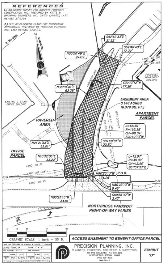
EXHIBIT E
“Office Access Easement Parcel”
All that tract or parcel of land lying and being in Land Lots 25 and 26 of the 17th District, Fulton County, Georgia, described as follows:
Beginning at a point at the intersection of the Northerly right-of-way line of Northridge Parkway (right-of-way varies) with the West line of said Land Lot 385, said point being the Point of Beginning; THENCE leaving said intersection and traveling along said right-of-way line of Northridge Parkway, the following three (3) courses and distances, North 80 degrees 23 minutes 13 seconds West for a distance of 43.75 feet to a Point; THENCE South 09 degrees 36 minutes 47 seconds West for a distance of 3.47 feet to a Point; THENCE North 80 degrees 23 minutes 13 seconds West for a distance of 34.91 feet to a Point; THENCE leaving said Right-of-Way, North 10 degrees 32 minutes 06 seconds East for a distance of 33.22 feet to a Point; THENCE North 21 degrees 21 minutes 55 seconds East for a distance of 16.84 feet to a Point, said Point being the True Point of Beginning.
THENCE from said Point as thus established, along a curve to the right having a radius of 35.77 feet and an arc length of 2.81 feet, being subtended by a chord of North 31 degrees 40 minutes 55 seconds West for a distance of 2.81 feet to a Point; THENCE along a curve to the right having a radius of 61.45 feet and an arc length of 92.00 feet, being subtended by a chord of North 09 degrees 12 minutes 15 seconds East for a distance of 83.64 feet to a Point; THENCE along a curve to the left having a radius of 10.00 feet and an arc length of 9.18 feet, being subtended by a chord of North 25 degrees 47 minutes 05 seconds East for a distance of 8.86 feet to a Point; THENCE North 00 degrees 31 minutes 33 seconds West for a distance of 2.08 feet to a Point; THENCE North 89 degrees 28 minutes 25 seconds East for a distance of 10.50 feet to a Point; THENCE North 00 degrees 34 minutes 26 seconds West for a distance of 14.17 feet to a Point; THENCE North 66 degrees 28 minutes 22 seconds East for a distance of 19.89 feet to a Point; THENCE along a curve to the left having a radius of 85.00 feet and an arc length of 28.76 feet, being subtended by a chord of North 56 degrees 46 minutes 42 seconds East for a distance of 28.63 feet to a Point; THENCE South 00 degrees 50 minutes 49 seconds West for a distance of 24.34 feet to a Point; THENCE South 36 degrees 10 minutes 26 seconds West for a distance of 92.75 feet to a Point; THENCE South 21 degrees 21 minutes 55 seconds West for a distance of 36.18 feet to a Point, said Point being the True Point of Beginning.
Said Property contains 0.085 acres (3,722 square feet).
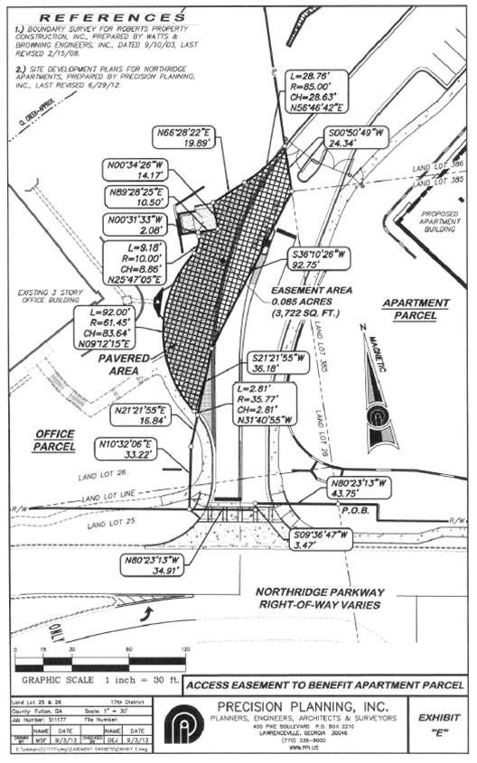
EXHIBIT F
“Temporary Construction Easement Parcel”
All that tract or parcel of land lying and being in Land Lots 25 and 26 of the 17th District, Fulton County, Georgia, described as follows:
Beginning at a point at the intersection of the Northerly right-of-way line of Northridge Parkway (right-of-way varies) with the West line of said Land Lot 385, said point being the Point of Beginning; THENCE leaving said intersection and traveling along said right-of-way line of Northridge Parkway, the following three (3) courses and distances, North 80 degrees 23 minutes 13 seconds West for a distance of 43.75 feet to a Point; THENCE South 09 degrees 36 minutes 47 seconds West for a distance of 3.47 feet to a Point; THENCE North 80 degrees 23 minutes 13 seconds West for a distance of 34.91 feet to a Point, said Point being the True Point of Beginning.
THENCE from said Point as thus established and continuing along said Right-of-Way, North 80 degrees 23 minutes 13 seconds West for a distance of 27.86 feet to a Point; THENCE leaving said Right-of-Way, North 09 degrees 36 minutes 47 seconds East for a distance of 240.12 feet to a Point; THENCE South 80 degrees 23 minutes 13 seconds East for a distance of 9.25 feet to a Point; THENCE North 57 degrees 05 minutes 26 seconds East for a distance of 25.06 feet to a Point; THENCE North 63 degrees 03 minutes 09 seconds East for a distance of 43.83 feet to a Point; THENCE South 00 degrees 50 minutes 49 seconds West for a distance of 116.44 feet to a Point; THENCE South 36 degrees 10 minutes 26 seconds West for a distance of 92.75 feet to a Point; THENCE South 21 degrees 21 minutes 55 seconds West for a distance of 53.01 feet to a Point; THENCE South 10 degrees 32 minutes 06 seconds West for a distance of 33.22 feet to a Point said Point being the True Point of beginning.
Said Property contains 0.331 acres (14,426 square feet).
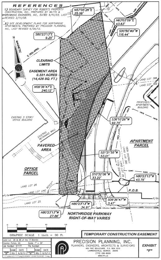
EXHIBIT G
“Landscape Easement Parcel”
All that tract or parcel of land lying and being in Land Lots 25 and 26 of the 17th District, Fulton County, Georgia, described as follows:
Beginning at a point at the intersection of the Northerly right-of-way line of Northridge Parkway (right-of-way varies) with the West line of said Land Lot 385, said point being the Point of Beginning; THENCE leaving said intersection and traveling along said right-of-way line of Northridge Parkway, the following three (3) courses and distances, North 80 degrees 23 minutes 13 seconds West for a distance of 43.75 feet to a Point; THENCE South 09 degrees 36 minutes 47 seconds West for a distance of 3.47 feet to a Point; THENCE North 80 degrees 23 minutes 13 seconds West for a distance of 34.91 feet to a Point, said Point being the True Point of Beginning.
THENCE from said Point as thus established and continuing along said Right-of-Way, North 80 degrees 23 minutes 13 seconds West for a distance of 27.86 feet to a Point; THENCE leaving said Right-of-Way, North 09 degrees 36 minutes 47 seconds East for a distance of 240.12 feet to a Point; THENCE South 80 degrees 23 minutes 13 seconds East for a distance of 9.25 feet to a Point; THENCE North 57 degrees 05 minutes 26 seconds East for a distance of 25.06 feet to a Point; THENCE North 63 degrees 03 minutes 09 seconds East for a distance of 43.83 feet to a Point; THENCE South 00 degrees 50 minutes 49 seconds West for a distance of 116.44 feet to a Point; THENCE South 36 degrees 10 minutes 26 seconds West for a distance of 92.75 feet to a Point; THENCE South 21 degrees 21 minutes 55 seconds West for a distance of 53.01 feet to a Point; THENCE South 10 degrees 32 minutes 06 seconds West for a distance of 33.22 feet to a Point said Point being the True Point of beginning.
Said Property contains 0.331 acres (14,426 square feet).
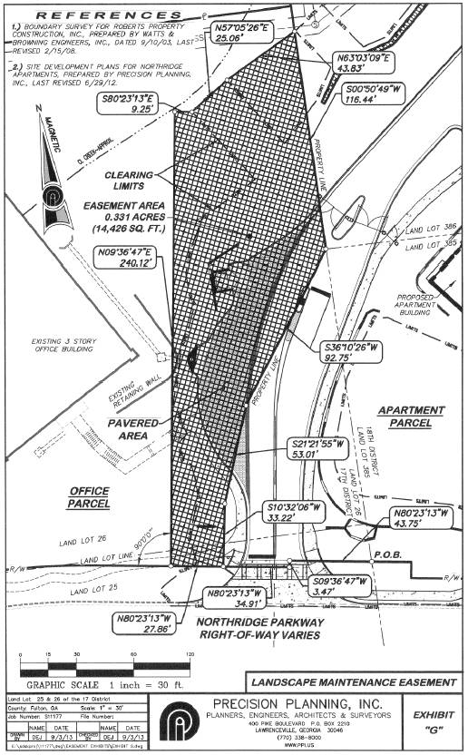
EXHIBIT H
“Sign Easement Parcel”
All that tract or parcel of land lying and being in Land Lots 25 and 26 of the 17th District, Fulton County, Georgia, described as follows:
Beginning at a point at the intersection of the Northerly right-of-way line of Northridge Parkway (right-of-way varies) with the West line of Land Lot 385, said point being the Point of Beginning; THENCE leaving said intersection and traveling along said right-of-way line of Northridge Parkway the following three (3) courses and distances, North 80 degrees 23 minutes 13 seconds West for a distance of 43.75 feet to a Point; THENCE South 09 degrees 36 minutes 47 seconds West for a distance of 3.47 feet to a Point; THENCE North 80 degrees 23 minutes 13 seconds West for a distance of 34.91 feet to a Point, said Point being the True Point of Beginning.
THENCE from said Point as thus established and continuing along said Right-of-Way, North 80 degrees 23 minutes 13 seconds West for a distance of 25.00 feet to a Point; THENCE leaving said Right-of-Way, North 10 degrees 32 minutes 06 seconds East for a distance of 30.00 feet to a Point; THENCE South 80 degrees 23 minutes 13 seconds East for a distance of 25.00 feet to a Point; THENCE South 10 degrees 32 minutes 06 seconds West for a distance of 30.00 feet to a Point, said Point being the True Point of beginning.
Said Property contains 0.017 acres (750 square feet).
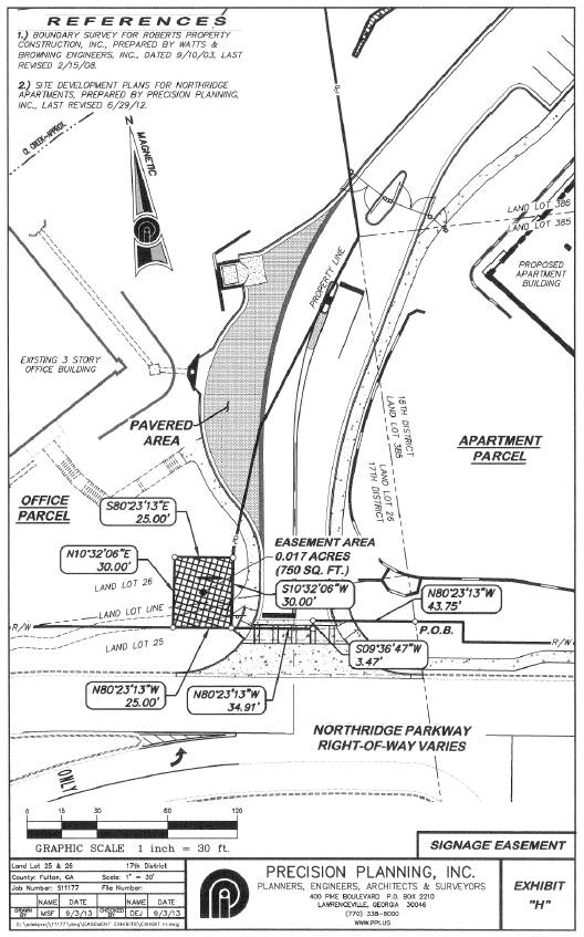
EXHIBIT I
“Utility Easement Parcel”
Land Lots 25 and 26 of the 17th District, Fulton County, Georgia, described as follows:
Beginning at a point at the intersection of the Northerly right-of-way line of Northridge Parkway (right-of-way varies) with the West line of Land Lot 385, said point being the Point of Beginning; THENCE leaving said intersection and traveling along said right-of-way line of Northridge Parkway the following three (3) courses and distances, North 80 degrees 23 minutes 13 seconds West for a distance of 43.75 feet to a Point; THENCE South 09 degrees 36 minutes 47 seconds West for a distance of 3.47 feet to a Point; THENCE North 80 degrees 23 minutes 13 seconds West for a distance of 34.91 feet to a Point, said Point being the True Point of Beginning.
THENCE from said Point as thus established and continuing along said Right-of-Way, North 80 degrees 23 minutes 13 seconds West for a distance of 15.00 feet to a Point; THENCE leaving said Right-of-Way, North 10 degrees 32 minutes 06 seconds East for a distance of 33.46 feet to a Point; THENCE North 21 degrees 06 minutes 01 seconds East for a distance of 57.78 feet to a Point; THENCE North 25 degrees 42 minutes 30 seconds East for a distance of 96.90 feet to a Point; THENCE North 58 degrees 05 minutes 59 seconds East for a distance of 30.00 feet to a Point; THENCE North 45 degrees 19 minutes 13 seconds East for a distance of 1.47 feet to a Point; THENCE South 00 degrees 50 minutes 49 seconds West for a distance of 36.61 feet to a Point; THENCE South 36 degrees 10 minutes 26 seconds West for a distance of 92.75 feet to a Point; THENCE South 21 degrees 21 minutes 55 seconds West for a distance of 53.01 feet to a Point; THENCE South 10 degrees 32 minutes 06 seconds West a distance of 33.22 feet to the POINT OF BEGINNING;
Said property contains 0.093 acres (4,043 square feet).
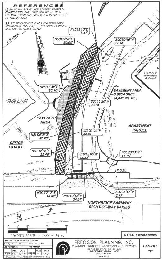
EXHIBIT J
No Parking Area
All that tract or parcel of land lying and being in Land Lots 25 and 26 of the 17th District, and in Land Lots 385 and 386 of the 18th District, Fulton County, Georgia, described as follows:
Beginning at a point at the intersection of the Northerly right-of-way line of Northridge Parkway (right-of-way varies) with the West line of said Land Lot 385, said point being the Point of Beginning; THENCE running along said right-of-way line of Northridge Parkway, North 80 degrees 23 minutes 13 seconds West for a distance of 34.28 feet to a Point, said Point being the True Point of beginning.
THENCE from said Point as thus established and continuing along said Right-of-Way the following three (3) courses and distances, North 80 degrees 23 minutes 13 seconds West for a distance of 9.46 feet to a Point; THENCE South 09 degrees 36 minutes 47 seconds West for a distance of 3.47 feet to a Point; THENCE North 80 degrees 23 minutes 13 seconds West for a distance of 26.74 feet a Point; THENCE leaving said Right-of-Way along a curve to the left having a radius of 35.00 feet and an arc length of 16.53 feet, being subtended by a chord of North 23 degrees 00 minutes 37 seconds East for a distance of 16.37 feet to a Point; THENCE North 09 degrees 13 minutes 01 seconds East for a distance of 8.23 feet to a Point; THENCE North 08 degrees 38 minutes 16 seconds East for a distance of 49.96 feet to a Point; THENCE along a curve to the right having a radius of 192.14 feet and an arc length of 129.52 feet, being subtended by a chord of North 27 degrees 57 minutes 51 seconds East for a distance of 127.09 feet to a Point; THENCE South 42 degrees 42 minutes 33 seconds East for a distance of 17.81 feet to a Point; THENCE South 59 degrees 46 minutes 48 seconds East for a distance of 17.72 feet to a Point; THENCE South 30 degrees 13 minutes 12 seconds West for a distance of 77.26 feet to a Point; THENCE along a curve to the left having a radius of 195.38 feet and an arc length of 68.39 feet, being subtended by a chord of South 20 degrees 19 minutes 13 seconds West for a distance of 68.04 feet to a Point; THENCE South 09 degrees 29 minutes 01 seconds West for a distance of 22.30 feet to a Point; THENCE along a curve to the left having a radius of 35.00 feet and an arc length of 12.97 feet, being subtended by a chord of South 01 degrees 07 minutes 57 seconds East for a distance of 12.90 feet to a Point, said Point being the True Point of Beginning.
Said Property contains 0.162 acres (7,038 square feet).
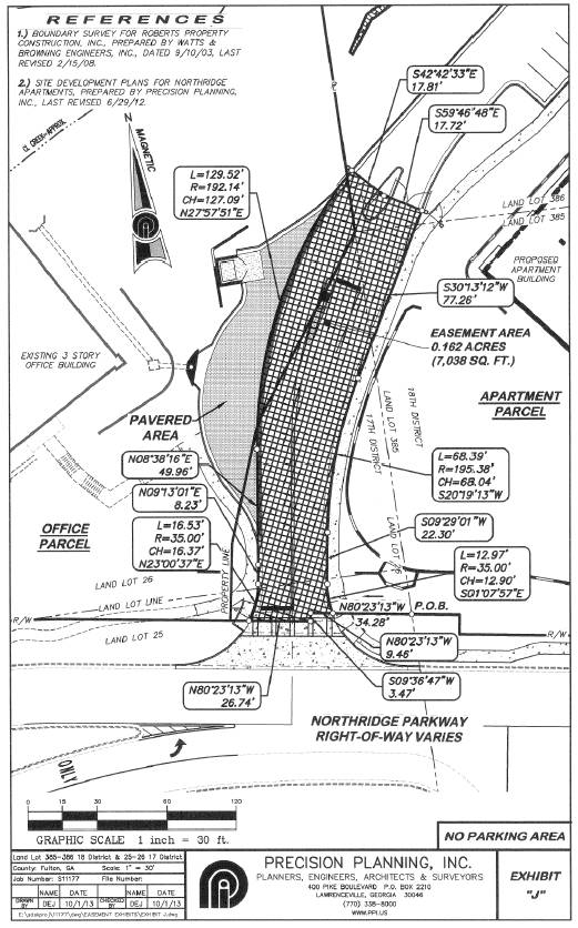
EXHIBIT K
All that tract or parcel of land lying and being in Land Lots 25 and 26 of the 17th District, and in Land Lots 385 and 386 of the 18th District, Fulton County, Georgia, described as follows:
Beginning at a point at the intersection of the Northerly right-of-way line of Northridge Parkway (right-of-way varies) with the West line of said Land Lot 385, said point being the Point of Beginning; THENCE running along said right-of-way line of Northridge Parkway, North 80 degrees 23 minutes 13 seconds West for a distance of 34.28 feet to a Point, said Point being the True Point of beginning.
THENCE from said Point as thus established and continuing along said Right-of-Way the following three (3) bearings and distances, North 80 degrees 23 minutes 13 seconds West for a distance of 9.46 feet to a Point; THENCE South 09 degrees 36 minutes 47 seconds West for a distance of 3.47 feet to a Point; THENCE North 80 degrees 23 minutes 13 seconds West for a distance of 62.77 feet to a Point; THENCE leaving said Right-of-Way, North 09 degrees 36 minutes 47 seconds East for a distance of 240.12 feet to a Point; THENCE South 80 degrees 23 minutes 13 seconds East for a distance of 9.25 feet to a Point; THENCE North 57 degrees 05 minutes 26 seconds East for a distance of 25.06 feet to a Point; THENCE North 63 degrees 03 minutes 09 seconds East for a distance of 43.83 feet to a Point; THENCE South 00 degrees 50 minutes 49 seconds West for a distance of 87.36 feet to a Point; THENCE South 42 degrees 42 minutes 33 seconds East for a distance of 21.22 feet to a Point; THENCE South 59 degrees 46 minutes 48 seconds East for a distance of 17.72 feet to a Point; THENCE South 30 degrees 13 minutes 12 seconds West for a distance of 77.26 feet to a Point; THENCE along a curve to the left having a radius of 195.38 feet and an arc length of 68.39 feet, being subtended by a chord of South 20 degrees 19 minutes 13 seconds West for a distance of 68.04 feet to a Point; THENCE South 09 degrees 29 minutes 01 seconds West for a distance of 22.30 feet to a Point; THENCE along a curve to the left having a radius of 35.00 feet and an arc length of 12.97 feet, being subtended by a chord of South 01 degrees 07 minutes 57 seconds East for a distance of 12.90 feet to a Point, said Point being the True Point of Beginning.
Said Property contains 0.478 acres (20,805 square feet).