Attached files
| file | filename |
|---|---|
| EX-31.1 - EX-31.1 - AV Homes, Inc. | d517837dex311.htm |
| EX-31.2 - EX-31.2 - AV Homes, Inc. | d517837dex312.htm |
| EX-10.48 - EX-10.48 - AV Homes, Inc. | d517837dex1048.htm |
| 10-K/A - FORM 10-K/A - AV Homes, Inc. | d517837d10ka.htm |
Exhibit 10.47
AGREEMENT FOR DEVELOPMENT OF POINCIANA PARKWAY
By and Between
OSCEOLA COUNTY, FLORIDA
POLK COUNTY, FLORIDA
AVATAR PROPERTIES INC.
AND
OSCEOLA COUNTY EXPRESSWAY AUTHORITY
TABLE OF CONTENTS
| PAGE | ||||||
| ARTICLE I | ||||||
| DEFINITIONS AND INTERPRETATION | ||||||
| SECTION 1.01. RECITALS |
4 | |||||
| SECTION 1.02. DEFINITIONS |
4 | |||||
| SECTION 1.03. INTERPRETATION |
10 | |||||
| SECTION 1.04. SECTION HEADINGS |
10 | |||||
| ARTICLE II | ||||||
| REPRESENTATIONS | ||||||
| SECTION 2.01. REPRESENTATIONS OF OSCEOLA COUNTY |
11 | |||||
| SECTION 2.02. REPRESENTATIONS OF POLK COUNTY |
11 | |||||
| SECTION 2.03. REPRESENTATIONS OF AVATAR |
12 | |||||
| SECTION 2.04. REPRESENTATIONS OF EXPRESSWAY AUTHORITY |
13 | |||||
| ARTICLE III | ||||||
| PLANS, PERMITS AND RIGHT-OF-WAY | ||||||
| SECTION 3.01. ASSIGNMENT OF AVATAR CONSTRUCTION PLANS |
15 | |||||
| SECTION 3.02. PERMIT TRANSFERS |
15 | |||||
| SECTION 3.03. UNFULFILLED OBLIGATIONS |
16 | |||||
| SECTION 3.04. RIGHT-OF-WAY CONVEYANCE |
16 | |||||
| SECTION 3.05. POINCIANA PARKWAY ESCROW AGREEMENT |
20 | |||||
| SECTION 3.06. SOUTHWEST SEGMENT RESERVATION AREA |
21 | |||||
| SECTION 3.07. CONVEYANCE OF ADDITIONAL RIGHT-OF-WAY |
23 | |||||
| SECTION 3.08. REEDY CREEK SETTLEMENT AGREEMENT |
24 | |||||
| ARTICLE IV | ||||||
| POINCIANA PARKWAY | ||||||
| SECTION 4.01. LEASE-PURCHASE AGREEMENT |
25 | |||||
| SECTION 4.02. DESIGN AND CONSTRUCTION |
25 | |||||
| SECTION 4.03. COUNTY STAFF SUPPORT |
30 | |||||
| SECTION 4.04. OPERATION AND MAINTENANCE |
30 | |||||
| SECTION 4.05. FUTURE CONSTRUCTION OF SOUTHWEST SEGMENT |
31 | |||||
| SECTION 4.06. EXPANSION OF NORTHWEST SEGMENT |
31 | |||||
| SECTION 4.07. FUTURE CONSTRUCTION 4-LANE BRIDGE SEGMENT |
32 | |||||
| SECTION 4.08. ACCESS MANAGEMENT |
32 | |||||
| SECTION 4.09. TRANSFER OF TITLE TO EXPRESSWAY AUTHORITY |
32 | |||||
| ARTICLE V | ||||||
i
| PLAN OF FINANCE | ||||
| SECTION 5.01. OSCEOLA COUNTY CONTRIBUTION |
34 | |||
| SECTION 5.02. POLK COUNTY CONTRIBUTION |
34 | |||
| SECTION 5.03. ISSUANCE OF SERIES 2013 BONDS |
35 | |||
| SECTION 5.04. REPAYMENT OF COUNTY FUNDS |
36 | |||
| SECTION 5.05. EXPRESSWAY AUTHORITY REQUISITIONS |
36 | |||
| SECTION 5.06. COMPLETION BONDS |
37 | |||
| SECTION 5.07. APPLICATION OF EXCESS SYSTEM REVENUE |
37 | |||
| ARTICLE VI | ||||
| GENERAL PROVISIONS | ||||
| SECTION 6.01. INTERLOCAL AGREEMENT PROVISIONS |
38 | |||
| SECTION 6.02. TERM OF AGREEMENT |
38 | |||
| SECTION 6.03. PRIOR AGREEMENTS |
38 | |||
| SECTION 6.04. VESTED RIGHTS STATUS |
39 | |||
| SECTION 6.05. EXPRESSWAY AUTHORITY’S FAILURE TO PERFORM |
39 | |||
| SECTION 6.06. FURTHER ASSURANCES |
39 | |||
| SECTION 6.07. DISPUTE RESOLUTION |
40 | |||
| SECTION 6.08. ASSIGNMENT |
40 | |||
| SECTION 6.09. PROFESSIONAL FEES |
40 | |||
| SECTION 6.10. TIME OF THE ESSENCE |
41 | |||
| SECTION 6.11. EXTENSION OF TIME PERIODS |
41 | |||
| SECTION 6.12. NO JOINT VENTURE |
41 | |||
| SECTION 6.13. NON-WAIVER |
41 | |||
| SECTION 6.14. COUNTERPARTS |
41 | |||
| SECTION 6.15. ENTIRE AGREEMENT |
41 | |||
| SECTION 6.16. LIMITATION OF AVATAR LIABILITY |
41 | |||
| SECTION 6.17. BINDING EFFECT |
41 | |||
| SECTION 6.18. AMENDMENTS AND WAIVERS |
41 | |||
| SECTION 6.19. NOTICES TO PARTIES |
42 | |||
| SECTION 6.20. SEVERABILITY |
43 | |||
| SECTION 6.21. GOVERNING LAW AND VENUE |
43 | |||
| SECTION 6.22. LITIGATION |
44 | |||
ii
TABLE OF APPENDICES
| APPENDIX A |
AVATAR ENGINEERS | |
| APPENDIX B |
DEPICTION OF POINCIANA PARKWAY | |
| APPENDIX C |
AVATAR CONSTRUCTION PLANS | |
| APPENDIX D |
RIGHT-OF-WAY PARCELS | |
| APPENDIX E |
PERMIT TRANSFERS | |
| APPENDIX F |
DESIGN CRITERIA | |
| APPENDIX G |
RIGHT-OF-WAY DEPICTION | |
| APPENDIX H |
DESCRIPTION OF SOUTHWEST SEGMENT CORRIDOR | |
| APPENDIX I |
DESCRIPTION OF THE RHODODENDRON EXTENSION CORRIDOR | |
| APPENDIX J |
DESCRIPTION OF SOUTHWEST SEGMENT RESERVATION AREA | |
| APPENDIX K |
DEPICTION OF CONCURRENCY RIGHT-OF-WAY | |
| APPENDIX L |
UNFULFILLED OBLIGATIONS | |
| APPENDIX M |
DRAINAGE FACILITIES AND PONDS | |
| APPENDIX N |
FORM OF STORMWATER DRAINAGE, CONSTRUCTION AND MAINTENANCE EASEMENT AGREEMENT | |
| APPENDIX O |
FORM OF ASSIGNMENT AND ASSUMPTION OF CONSTRUCTION PLANS | |
| APPENDIX P |
FORM OF ASSIGNMENT AND ASSUMPTION OF PERMITS | |
| APPENDIX Q |
FORM OF ASSIGNMENT AND ASSUMPTION OF UNFULFILLED OBLIGATIONS | |
| APPENDIX R |
FORM OF ASSIGNMENT AND ASSUMPTION OF REEDY CREEK AGREEMENT | |
| APPENDIX S |
DEPICTION OF VESTED PROPERTY |
iii
AGREEMENT FOR DEVELOPMENT OF POINCIANA PARKWAY
THIS AGREEMENT FOR DEVELOPMENT OF POINCIANA PARKWAY (this “Development Agreement”) is made and entered into as of October 15, 2012 by and between Osceola County, a charter county and political subdivision of the State of Florida (“Osceola County”), Polk County, a charter county and political subdivision of the State of Florida (“Polk County”), Avatar Properties Inc., a Florida corporation (“Avatar”) and the Osceola County Expressway Authority, a body politic and corporate created by Part V, chapter 348, Florida Statutes (the “Expressway Authority”).
W I T N E S S E T H:
WHEREAS, the parties to this Development Agreement acknowledge and agree that Poinciana Parkway, a controlled access arterial roadway extending from the current intersection of U.S. 17-92 and County Road 54 in Polk County to Cypress Parkway (CR 580), would be an important element in the traffic circulation systems of Osceola County and Polk County; and
WHEREAS, Poinciana Parkway has been adopted as part of the Osceola County Comprehensive Plan, Polk County Comprehensive Plan, Orlando Metropolitan Planning Organization Long Range Transportation Plan, and the Lakeland/Winter Haven Urbanized Area Metropolitan Planning Organization 2010 Long Range Transportation Study Cost Feasible Element; and
WHEREAS, Poinciana Parkway, formerly named the “Parker Highway Project,” was identified by the Polk County Transportation Planning Organization (TPO) in its 2025 Long Range Transportation Plan as a proposed new two-lane arterial public road project which would be built by means of a public/private partnership and with private funding; and
WHEREAS, in reliance on this proposed collector public road project connecting Polk County and Osceola County, Polk County has included traffic projections for this road in its long range transportation planning for the northeast section of Polk County and has undertaken and completed construction of capacity improvements to CR54 (Ronald Reagan Parkway) to accommodate traffic from Poinciana Parkway; and
WHEREAS, Poinciana Parkway will create an additional hurricane evacuation route and increase access for public safety and emergency vehicles and enhance the overall development potential of property located not only along the Poinciana Parkway corridor, but throughout Osceola County and Polk County, thus increasing the ad valorem tax base and benefiting the citizens of Osceola County and Polk County; and
WHEREAS, Poinciana Parkway will ease the flow of vehicular traffic within Osceola County and Polk County and provide more direct access from Poinciana to U.S. 17-92 than is currently available and will provide a more convenient and quicker access to Interstate 4 and the Western Beltway, thereby providing the citizens of Osceola County and Polk County (particularly the residents of Poinciana), tourists and other temporary visitors to Osceola County and Polk County a direct connection to the Orlando-area beltway; and
1
WHEREAS, construction of Poinciana Parkway as a collector road connecting Polk County and Osceola County will provide employment opportunities, promote development and have a significant positive effect on the general economy of Osceola County and Polk County and will serve a valid public purpose of Osceola County and Polk County; and
WHEREAS, Avatar and Osceola County have previously entered into a Transportation Concurrency Agreement, dated December 15, 2006, which has been amended by an Amendment to Transportation Concurrency Agreement dated as of July 25, 2008, a Second Amendment to Transportation Concurrency Agreement dated as of December 20, 2010, and an Extension Agreement, dated as of February 6, 2012 (collectively, the “Concurrency Agreement”); and
WHEREAS, the Concurrency Agreement, among other things, requires Avatar to finance the acquisition, development and construction of Poinciana Parkway and begin actual construction not later than February 14, 2013 and requires that Poinciana Parkway be substantially complete and open to traffic not later than May 7, 2015; and
WHEREAS, the Concurrency Agreement further provides that if Avatar fails to comply with the terms and conditions set forth therein (including the timely construction of Poinciana Parkway), the Concurrency Agreement becomes null and void and all aspects of the Vested Property (as defined in the Concurrency Agreement) shall be subject to all transportation concurrency requirements then in effect; and
WHEREAS, simultaneously with the Concurrency Agreement, Avatar and Osceola County entered into a Property Acquisition Agreement, dated December 15, 2006 (the “Acquisition Agreement”), pursuant to which Osceola County agreed to exercise its power of eminent domain for the acquisition of certain property required for the construction of Poinciana Parkway; and
WHEREAS, simultaneously with the Concurrency Agreement and Acquisition Agreement, Avatar and Osceola County entered into a Poinciana Parkway Regulatory Agreement, which has been amended and restated in its entirety by the First Amended and Restated Poinciana Parkway Regulatory Agreement dated as of July 25, 2008, the First Amendment to First Amended and Restated Poinciana Parkway Regulatory Agreement dated as of December 20, 2010, and an Extension Agreement, dated as of February 6, 2012 (collectively, the “Osceola Regulatory Agreement”); and
WHEREAS, the Osceola Regulatory Agreement, among other things, requires Avatar and its permitted assignees to design, construct and operate Poinciana Parkway as a private toll road, grants Avatar the right to establish tolls within certain specified limits; and
WHEREAS, Avatar and Polk County have previously entered into a Poinciana Parkway Regulatory Agreement (Polk County), dated December 20, 2006, which has been amended and restated in its entirety by the First Amended and Restated Poinciana Parkway Regulatory Agreement (Polk County), dated as of August 6, 2008, the First Amendment to First Amended and Restated Poinciana Parkway Regulatory Agreement (Polk County), dated as of October 20, 2010 (collectively, the “Polk Regulatory Agreement”) for the purpose of providing for a public/private partnership for the ultimate construction of a continuous collector road beginning
2
at the existing intersection of CR54 and US 17/92 in Polk County and terminating in Osceola County at the intersection of Marigold Avenue and Cypress Parkway; and
WHEREAS, Avatar has made an extensive, but to date unsuccessful, effort to finance the construction of Poinciana Parkway as a private toll road; and
WHEREAS, on July 1, 2010, the Florida Legislature created the Osceola County Expressway Authority by enactment of CS/CS/CS/HB-1271, codified as Part V, Chapter 348, Florida Statutes; and
WHEREAS, Osceola County, Polk County and Avatar desire to restructure their contractual relationships to accommodate construction and operation of Poinciana Parkway as a continuous collector road beginning in Polk County and terminating in Osceola County in accordance with the terms of this Development Agreement; and
WHEREAS, the funding, construction, operation and maintenance of Poinciana Parkway by Osceola County, Polk County and the Expressway Authority in accordance with the terms of this Development Agreement will enhance the development potential of nearby property owned by Avatar and, together with other considerations set forth in this Development Agreement, is adequate consideration for the Avatar’s agreement to transfer and convey the plans, permits and right-of-way necessary for the construction of Poinciana Parkway, as required by Article III hereof;
NOW THEREFORE, in consideration of the mutual promises, covenants and agreements contained herein and other valuable consideration, receipt of which is hereby acknowledged, the parties mutually undertake, promise and agree for themselves, their successors and assigns as follows:
3
ARTICLE I
DEFINITIONS AND INTERPRETATION
SECTION 1.01. RECITALS. The parties agree that the recitals are true and correct and by this reference incorporated and made a part of this Development Agreement.
SECTION 1.02. DEFINITIONS. As used in this Development Agreement, the following terms shall have the following meanings unless the context hereof otherwise requires:
“Acquisition Agreement” means the Property Acquisition Agreement, dated December 15, 2006, between Avatar and Osceola County.
“Additional Bonds” means any series of bonds, notes or other obligations issued by Osceola County or the Expressway Authority on a parity with the Series 2013 Bonds.
“Avatar” means Avatar Properties Inc., a Florida corporation.
“Avatar Construction Plans” means the Poinciana Parkway plans, specifications and other engineering documents prepared by the Avatar Engineers to plan or design portions of Poinciana Parkway, all of which are listed in Appendix C attached hereto and made a part hereof.
“Avatar Engineers” means those engineers, firms and consultants listed in Appendix A, attached hereto and made a part hereof, engaged by Avatar to prepare the Avatar Construction Plans.
“Avatar Investment” means $48,000,000, which represents the approximate amount represented by Avatar as heretofore expended by Avatar to design and finance the construction of Poinciana Parkway.
“Avatar Reserved Rights” means the rights and privileges set forth in subsections (D) and (E) of Section 3.04 hereof.
“Bridge Segment” means the approximately 4.15 mile controlled access segment of Poinciana Parkway between from East Bourne Road and the Osceola/Polk County line, as more particularly depicted on Appendix B attached hereto and made a part hereof.
“Concurrency Agreement” means the Transportation Concurrency Agreement dated December 15, 2006 between Osceola County and Avatar, as amended by that certain Amendment to Transportation Concurrency Agreement dated July 25, 2008, that certain Second Amendment to Transportation Concurrency Agreement dated December 20, 2010, an Extension Agreement, dated as of February 6, 2012, and the Judge Farms Acquisition Agreement.
“Concurrency Right-of-Way” means additional right-of-way for (A) Marigold Avenue from Cypress Parkway to Eastbourne Road – 2 lanes to 4 lanes, (B) Koa Street from Marigold Avenue to Doverplum Avenue – 2 lanes to 4 lanes, (C) Doverplum Avenue from Old Pleasant Hill Extension to Koa Street – 2 lanes to 4 lanes, (D) Poinciana Boulevard from Pleasant Hill Road to Reaves Road – 2 lanes to 4 lanes, (E) Bayberry Avenue from Walnut Street to Old
4
Pleasant Hill Extension – 4 lanes, (F) Old Pleasant Hill Extension from Bayberry Avenue to Cypress Parkway – 4 lanes, and Southport Connector – 4 lanes, as depicted in Appendix K attached hereto and made a part hereof.
“Construction Manager” means the “construction management entity” (as defined in Section 255.32(4), Florida Statutes) as may be selected by the Expressway Authority in accordance with its adopted policies and procedures.
“Construction Management Agreement” means any agreement entered into pursuant to Section 4.02(C) hereof between the Expressway Authority and the Construction Manager.
“Construction Plans” means the Avatar Construction Plans, as modified pursuant to Section 4.02 hereof.
“Design-Build Agreement” means any agreement entered into pursuant to Section 4.02(C) hereof between the Expressway Authority and the Design-Builder.
“Design-Builder” means the “design-build firm” (as defined in section 287.055(2)(h), Florida Statutes) as may be selected by the Expressway Authority in accordance with its adopted policies and procedures.
“Design Criteria” means the criteria for Poinciana Parkway design and engineering, as set forth in Appendix F attached hereto and made a part hereof.
“Design Plan Stage” means the thirty percent, sixty percent, ninety percent and one hundred percent design completion stage.
“Development Agreement” means this Agreement for Development of Poinciana Parkway, including any amendments and supplements hereto executed and delivered in accordance with the terms hereof.
“Effective Date” means the date shown in the first paragraph of this Development Agreement.
“Expressway Authority” means the Osceola County Expressway Authority, a body politic and corporate created by Part V, Chapter 348, Florida Statutes.
“Expressway Representative” means the chair of the Expressway Authority’s governing board and such person’s designees, as designated in writing to Osceola County and Polk County, and when used in reference to any act or document, also means any other person authorized by resolution of the Expressway Authority’s governing body to perform such act or sign such document.
“Expressway Revenue Bonds” means the Series 2013 Bonds and any Additional Bonds issued by Osceola County.
“Expressway System” means the Bridge Segment, the Southwest Segment, the Rhododendron Extension, the “Southport Connector Expressway,” the “Northeast Connector
5
Expressway,” and the “Poinciana Parkway Connector,” either as depicted in the Expressway Authority’s 2040 Master Plan or as more particularly depicted on Appendix B attached hereto and made a part hereof.
“FDOT” means the Florida Department of Transportation.
“Fiscal Year” means that period commencing October 1 of each year and continuing through the next succeeding September 30, or such other period as may be prescribed by law as the fiscal year for Osceola County, Polk County and the Expressway Authority.
“Force Majeure” means acts or events which reasonably relate to the performance of a term or condition hereof, including, without limitation, any major event of nature, floods, unintended fires, hurricanes, accidents, strikes, labor shortages, major breakdowns of essential equipment, acts of war or terrorism, actions of government other than the actions of the parties hereto, foreseen or unforeseen, or similar events or causes, which are beyond the reasonable control of a party hereto and without the fault or negligence of a party hereto and adversely affect the practicability of constructing Poinciana Parkway. The term “Force Majeure” shall include delays resulting from third-party intervention and/or appeals in the issuance of Permit modifications.
“General Reserve Fund” means the “Osceola County, Florida Expressway General Reserve Fund” created pursuant to the Trust Agreement.
“Initial Project Account” means “Initial Project Account” of the “Osceola County, Florida Expressway Project Fund” created pursuant to the Trust Agreement.
“Judge Farms Acquisition Agreement” means the Real Property Purchase Agreement between Osceola County and Avatar, executed by Avatar on June 29, 2012 and approved by Osceola County’s Board of Commissioners on July 16, 2012.
“Lease-Purchase Agreement” means the Lease-Purchase Agreement between Osceola County and the Expressway Authority described in Section 4.01 hereof.
“Letters of Credit” means Letters of Credit No. 63660367, dated April 11, 2012, and No. 63660368, dated March 29, 2012, issued by Citibank, N.A. in favor of Osceola County and Polk County, respectively.
“Non-Ad Valorem Funds” means all revenues of Osceola County or Polk County derived from any source whatsoever other than ad valorem taxation on real or personal property, which are legally available to make the payments required herein, but only after provision has been made by the Osceola County or Polk County for the payment of all essential or legally mandated services.
“Northwest Segment” means the approximately 1.34 mile segment of Poinciana Parkway following the existing alignment of Kinney Harmon Road between the Osceola/Polk County line on the east and the CR 54/U.S. 17-92 intersection on the west in Polk County, designed to provide a continuous and perpetual collector road connecting Polk County and Osceola , as more particularly depicted on Appendix B attached hereto and made a part hereof.
6
“Northwest Segment Project Cost” means the cost incurred by the Expressway Authority to expand the Northwest Segment.
“Osceola County” means Osceola County, Florida, a charter county and political subdivision of the State of Florida.
“Osceola County Expressway Authority Law” means Chapter 348, Part V, Florida Statutes, as amended from time to time.
“Osceola County’s Representative” means Osceola County’s chief executive officer and such person’s designees, as designated in writing to the Expressway Authority, and when used in reference to any act or document, also means any other person authorized by resolution of Osceola County’s Board of Commissioners to perform such act or sign such document.
“Osceola Regulatory Agreement” means the Poinciana Parkway Regulatory Agreement between Osceola County and Avatar dated December 15, 2006, as amended and restated in its entirety by that certain First Amended and Restated Poinciana Parkway Regulatory Agreement dated July 25, 2008, the First Amendment to First Amended and Restated Poinciana Parkway Regulatory Agreement dated December 20, 2010, an Extension Agreement, dated as of February 6, 2012, and the Judge Farms Acquisition Agreement.
“Parkway Completion Bonds” means the Additional Bonds, if any, issued by Osceola County pursuant to Section 5.06 hereof to complete the initial construction of Poinciana Parkway.
“Permit-Ready Design-Build Construction Documents” means construction documents delivered to the Expressway Authority by the Design-Builder to begin construction of any component of Poinciana Parkway or for submission to a regulatory agency for modification of a Permit.
“Permits” means those permits and approvals listed on Appendix E attached hereto and made a part hereof.
“Poinciana Parkway” means an approximately 9.66 mile controlled access collector road which will perpetually connect Polk County with Osceola County, beginning at the existing intersection of County Road 54 and US 17-92 in Polk County, Florida and terminating in Osceola County, Florida at Cypress Parkway (CR 580), including the Northwest Segment, the Bridge Segment, the Rhododendron Extension and the Southeast Segment or Southwest Segment, all of which are graphically shown and depicted on Appendix B.
“Poinciana Parkway Escrow Agreement” means the agreement to be entered into among Osceola County, the Expressway Authority, Avatar and a mutually acceptable escrow holder, to hold and deliver the instruments listed in Section 3.05 hereof.
“Poinciana Parkway Escrow Holder” means the person or entity designated in the Poinciana Parkway Escrow Agreement to hold and deliver the documents described in Sections 3.04 hereof.
7
“Poinciana Parkway Funding Agreement” means the agreement pursuant to which Osceola County agrees to deliver the Series 2013 Bonds against payment therefore by the purchaser or underwriter thereof, and on which the proceeds of the Series 2013 Bonds become available for use by the Expressway Authority for the initial design and construction of Poinciana Parkway.
“Poinciana Parkway Funding Date” means the date on which the Series 2013 Bonds are delivered pursuant to the Poinciana Parkway Funding Agreement and the proceeds of the Series 2013 Bonds become available for use by the Expressway Authority for the initial design and construction of Poinciana Parkway.
“Poinciana Parkway Project Cost” means the cost incurred by the Expressway Authority to acquire, design and construct Poinciana Parkway.
“Polk County” means Polk County, a charter county and political subdivision of the State of Florida.
“Polk County Funding Date” means the date established in Section 5.02(A) hereof.
“Polk Regulatory Agreement” means the Poinciana Parkway Regulatory Agreement (Polk County), dated December 20, 2006, which has been amended and restated in its entirety by the First Amended and Restated Poinciana Parkway Regulatory Agreement (Polk County), dated as of August 6, 2008, the First Amendment to First Amended and Restated Poinciana Parkway Regulatory Agreement (Polk County), dated as of October 20, 2010.
“Preliminary Design-Build Submittal” means the conceptual design submitted by the Design-Builder during the Expressway Authority’s selection process.
“Public Safety Site” means the approximately 9.827 acre parcel of land which is more particularly described as follows: Lots E and F, Poinciana Office and Industrial Park VII, according to the Plat thereof, as recorded in Plat Book 61, at Pages 4 and 5, Public Records of Polk County, Florida.
“Reedy Creek Agreement” means the Settlement Agreement between and among Avatar and American Properties Inc. and Reedy Creek Mitigation Land Bank, Ltd., American Equities Ltd. No. 7 originally dated April , 2007 and signed by the last of the parties thereto on May 8, 2007, as amended by the First Amendment to Reedy Creek Settlement Agreement between the parties, dated as of December 8, 2010.
“Revenues” means all receipts, revenues, income, proceeds and money received in any period by or for Osceola County or the Expressway Authority in respect of the Expressway System, as more particularly described in the Trust Agreement.
“Rhododendron Extension” means a new limited access roadway extending the Southwest Segment Corridor northward, as depicted in Appendix B attached hereto and made a part hereof.
8
“Rhododendron Extension Corridor” means the 300 foot right-of-way extending the Southwest Segment Corridor northward, as depicted in Appendix G attached hereto and made a part hereof, and described in Appendix I attached hereto and made a part hereof.
“Series 2013 Bond Yield” means a discount rate equal to the arbitrage true interest cost which will be computed in compliance with Federal Regulations as defined under sections 1.103-13(c), 1.148(b)(5), and 1.148-9T(a), i.e., the discount rate, assuming semi-annual compounding, at which aggregate payments of principal and interest on the Series 2013 Bonds have a present value equal to the issue price paid for the Series 2013 Bonds by the holders thereof; issue price being defined as the principal amount of Series 2013 Bonds, plus any accrued interest, less (A) any original issue discount or plus the original issue premium and (B) the cost of any bond insurance premium or liquidity or credit enhancement fee paid from the proceeds thereof.
“Series 2013 Bonds” means the bonds issued by Osceola County pursuant to Section 5.03 hereof.
“Southeast Segment” means the approximately 4.17 mile segment of Poinciana Parkway following the existing alignment of Marigold Avenue from Cypress Parkway to East Bourne Road in Osceola County, as more particularly depicted on Appendix B attached hereto and made a part hereof.
“Southwest Segment” means a new limited access roadway to be constructed generally along the alignment of Rhododendron Avenue in Osceola County, the approximate location of which is more particularly depicted in Appendix B attached hereto and made a part hereof.
“Southwest Segment Corridor” means the planned right-of-way of approximately 150 feet, adjacent and to the west of the platted corridor, owned and to be contributed by Avatar pursuant to Section 3.04 hereof, as depicted in Appendix G attached hereto and made a part hereof and described in Appendix H attached hereto and made a part hereof.
“Southwest Segment Escrow Agreement” means the agreement to hold and deliver documents conveying the portion of the Southwest Segment Reservation Area that will be utilized for construction of the Southwest Segment, as shown on the Permit-Ready Design-Build Construction Documents, as described in Section 4.02(D)(1)(b) hereof, or construction plans at the final Design Plan Stage, as described in Section 4.02(D)(2)(d) hereof. If the Southwest Segment is to be constructed from proceeds of the Series 2013 Bonds, the “Southwest Segment Escrow Agreement” shall mean the “Poinciana Parkway Escrow Agreement.”
“Southwest Segment Escrow Holder” means the person or entity designated in the Southwest Segment Escrow Agreement to hold and deliver the documents described in Section 3.8 hereof. If the Southwest Segment is to be constructed from proceeds of the Series 2013 Bonds, the “Southwest Segment Escrow Holder” shall mean the “Poinciana Parkway Escrow Holder.”
“Southwest Segment Funding Agreement” means the agreement pursuant to which Osceola County agrees to deliver Additional Bonds against payment therefore by the purchaser or underwriter thereof, and on which the proceeds of such Additional Bonds become available for use by the Expressway Authority for design and construction of Southwest Segment. If the
9
Southwest Segment is to be constructed from proceeds of the Series 2013 Bonds, the “Southwest Segment Funding Agreement” shall mean the “Poinciana Parkway Funding Agreement.”
“Southwest Segment Funding Date” means the date on which Additional Bonds are delivered pursuant to the Poinciana Parkway Funding Agreement. If the Southwest Segment is to be constructed from proceeds of the Series 2013 Bonds, the “Southwest Segment Funding Date” shall mean the “Poinciana Parkway Funding Date.”
“Southwest Segment Project Cost” means the cost incurred by the Expressway Authority to acquire, design and construct the Southwest Segment.
“Southwest Segment Release Date” means the date that is ten years from the Poinciana Parkway Funding Date.
“Southwest Segment Reservation Area” means the property depicted in Appendix G attached hereto and made a part hereof and described in Appendix J attached hereto and made a part hereof.
“Southwest Segment Reservation Area Restrictions” means the restrictions set forth in subsections (A) and (B) of Section 3.06 hereof.
“State” means the State of Florida.
“Trust Agreement” means the Trust Agreement securing the Expressway Revenue Bonds, and any supplements and amendments hereto permitted thereby.
“Unfulfilled Obligations” means unfulfilled agreements, conditions, requirements or actions agreed to by Avatar concerning the initial design and construction of Poinciana Parkway listed in Appendix L.
“Vested Property” means the property depicted in Appendix S.
SECTION 1.03. INTERPRETATION. Words importing the singular number shall include the plural in each case and vice versa, and words importing persons shall include firms and corporations. The terms “herein”, “hereunder”, “hereby”, “hereof”, and any similar terms, shall refer to this Development Agreement; the term “heretofore” shall mean before the date this Development Agreement is executed; and the term “hereafter” shall mean after the date this Development Agreement is executed. Whenever the word “including” is used herein, it shall be deemed to mean “without limitation.” Each recital, covenant, agreement, representation and warranty made by a party herein shall be deemed to have been material and to have been relied on by the other parties to this Development Agreement. All parties have participated in the drafting and preparation of this Development Agreement, and the provisions hereof shall not be construed for or against any party by reason of authorship.
SECTION 1.04. SECTION HEADINGS. Any headings preceding the texts of the several Sections of this Development Agreement and any table of contents or marginal notes appended to copies hereof, shall be solely for convenience of reference and shall neither constitute a part of this Development Agreement nor affect its meaning, construction or effect.
10
ARTICLE II
REPRESENTATIONS
SECTION 2.01. REPRESENTATIONS OF OSCEOLA COUNTY. Osceola County makes the following representations as the basis for the undertakings on the part of Polk County, Avatar and the Expressway Authority herein contained:
(A) Osceola County is a charter county and political subdivision of the State of Florida, and has all requisite power and authority to enter into the transactions contemplated by this Development Agreement and to carry out its obligations hereunder.
(B) Osceola County is not in default under any provisions of applicable law material to the performance of its obligations under this Development Agreement.
(C) Osceola County has duly authorized the execution and delivery of this Development Agreement, and assuming the due authorization, execution and delivery by the other parties hereto, this Development Agreement constitutes a valid and legally binding obligation of Osceola County, enforceable in accordance with its terms, except to the extent that the enforceability thereof may be limited by any applicable bankruptcy, insolvency, moratorium, reorganization or other similar laws affecting creditors’ rights generally, or by the exercise of judicial discretion in accordance with general principles of equity.
(D) The authorization, execution and delivery of this Development Agreement, and the compliance by Osceola County with the provisions hereof will not conflict with or constitute a material breach of, or default under, any existing law, court or administrative regulation, decree, order or any provision of the Constitution or laws of the State of Florida relating to Osceola County or its affairs, or any ordinance, resolution, agreement, mortgage, lease or other instrument to which Osceola County is subject or by which it is bound.
(E) There is no action, suit, proceeding or investigation at law or in equity before or by any court, public board or body pending or, to the best knowledge of Osceola County, threatened against or affecting Osceola County, wherein an unfavorable decision, ruling or finding would materially adversely affect the transactions contemplated hereby or which, in any way, would materially adversely affect the validity of this Development Agreement, or any agreement or instrument to which Osceola County is a party and which is used or contemplated for use in the consummation of the transactions contemplated hereby.
SECTION 2.02. REPRESENTATIONS OF POLK COUNTY. Polk County makes the following representations as the basis for the undertakings on the part of Osceola County, Avatar and the Expressway Authority herein contained:
(A) Polk County is duly organized and validly existing as a charter county and political subdivision of the State.
(B) Polk County has full power and authority to enter into the transactions contemplated by this Development Agreement and to carry out its obligations hereunder.
11
(C) Polk County is not in default under any provisions of the laws of the State material to the performance of its obligations under this Development Agreement.
(D) Polk County has duly authorized the execution and delivery of this Development Agreement, and assuming the due authorization, execution and delivery by the other parties hereto, this Development Agreement constitutes a valid and legally binding obligation of Polk County, enforceable in accordance with their respective terms, except to the extent that the enforceability thereof may be limited by any applicable bankruptcy, insolvency, moratorium, reorganization or other similar laws affecting creditors’ rights generally, or by the exercise of judicial discretion in accordance with general principles of equity or public policy.
(E) The authorization, execution and delivery of this Development Agreement and the compliance by Polk County with the provisions hereof will not conflict with or constitute a material breach of, or default under, any existing law, court or administrative regulation, decree, order or any provision of the Constitution or laws of the State relating to Polk County or its affairs, or any ordinance, resolution, agreement, mortgage, lease or other instrument to which Polk County is subject or by which it is bound.
(F) There is no action, suit, proceeding or investigation at law or in equity before or by any court, public board or body pending or, to the best knowledge of Polk County, threatened against or affecting Polk County, wherein an unfavorable decision, ruling or finding would materially adversely affect the transactions contemplated by this Development Agreement or which, in any way, would materially adversely affect the validity of this Development Agreement or any agreement or instrument to which Polk County is a party and which is used or contemplated for use in the consummation of the transactions contemplated hereby.
SECTION 2.03. REPRESENTATIONS OF AVATAR. Avatar makes the following representations as the basis for the undertakings on the part of Osceola County, Polk County and the Expressway Authority herein contained:
(A) Avatar is a Florida corporation, and has all requisite power and authority to enter into the transactions contemplated by this Development Agreement and to carry out its obligations hereunder.
(B) Avatar is not in default under any provisions of applicable law material to the performance of its obligations under this Development Agreement.
(C) Avatar has duly authorized the execution and delivery of this Development Agreement, and assuming the due authorization, execution and delivery by the other parties hereto, this Development Agreement constitutes a valid and legally binding obligation of Avatar, enforceable in accordance with its terms, except to the extent that the enforceability thereof may be limited by any applicable bankruptcy, insolvency, moratorium, reorganization or other similar laws affecting creditors’ rights generally, or by the exercise of judicial discretion in accordance with general principles of equity.
(D) The authorization, execution and delivery of this Development Agreement, and the compliance by Avatar with the provisions hereof will not conflict with or constitute a material breach of, or default under, any existing law, court or administrative regulation, decree,
12
order or any provision of the Constitution or laws of the State of Florida relating to Avatar or its affairs, or any ordinance, resolution, agreement, mortgage, lease or other instrument to which Avatar is subject or by which it is bound.
(E) There is no action, suit, proceeding or investigation at law or in equity before or by any court, public board or body pending or, to the best knowledge of Avatar, threatened against or affecting Avatar, wherein an unfavorable decision, ruling or finding would materially adversely affect the transactions contemplated hereby or which, in any way, would materially adversely affect the validity of this Development Agreement, or any agreement or instrument to which Avatar is a party and which is used or contemplated for use in the consummation of the transactions contemplated hereby.
SECTION 2.04. REPRESENTATIONS OF EXPRESSWAY AUTHORITY. The Expressway Authority makes the following representations as the basis for the undertakings on the part of Osceola County, Polk County and Avatar herein contained:
(A) The Expressway Authority is duly organized and validly existing as a a body politic and corporate created by Part V, Chapter 348, Florida Statutes.
(B) The Expressway Authority has full power and authority to enter into the transactions contemplated by this Development Agreement and to carry out its obligations hereunder.
(C) The Expressway Authority is not in default under any provisions of the laws of the State material to the performance of its obligations under this Development Agreement.
(D) The Expressway Authority has duly authorized the execution and delivery of this Development Agreement, and assuming the due authorization, execution and delivery by the other parties hereto, this Development Agreement constitutes a valid and legally binding obligation of the Expressway Authority, enforceable in accordance with their respective terms, except to the extent that the enforceability thereof may be limited by any applicable bankruptcy, insolvency, moratorium, reorganization or other similar laws affecting creditors’ rights generally, or by the exercise of judicial discretion in accordance with general principles of equity or public policy.
(E) The authorization, execution and delivery of this Development Agreement and the compliance by the Expressway Authority with the provisions hereof will not conflict with or constitute a material breach of, or default under, any existing law, court or administrative regulation, decree, order or any provision of the Constitution or laws of the State relating to the Expressway Authority or its affairs, or any ordinance, resolution, agreement, mortgage, lease or other instrument to which the Expressway Authority is subject or by which it is bound.
(F) There is no action, suit, proceeding or investigation at law or in equity before or by any court, public board or body pending or, to the best knowledge of the Expressway Authority, threatened against or affecting the Expressway Authority, wherein an unfavorable decision, ruling or finding would materially adversely affect the transactions contemplated by this Development Agreement or which, in any way, would materially adversely affect the validity of this Development Agreement or any agreement or instrument to which the
13
Expressway Authority is a party and which is used or contemplated for use in the consummation of the transactions contemplated hereby.
14
ARTICLE III
PLANS, PERMITS AND RIGHT-OF-WAY
SECTION 3.01. ASSIGNMENT OF AVATAR CONSTRUCTION PLANS. Within five days of the Effective Date, Avatar shall execute and deliver an Assignment and Assumption of Construction Plans to the Expressway Authority, in the form attached hereto as Appendix O, assigning all of its contractual, common law, statutory and other rights to and interests in the Avatar Construction Plans, including rights to supporting electronic design files, including ownership, licenses, and copyright, if any, in those documents and other property interests thereto, whether owned directly or by assignment from the Avatar Engineers, without representation or warranty of any kind, except that on a non-exclusive basis and except as otherwise provided and reserved herein. Between the Effective Date of this Development Agreement and the Poinciana Parkway Funding Date, Avatar agrees not to share, provide, sell or assign its contractual, common law, statutory or other rights to and interests on the Avatar Construction Plans as described in this Section 3.01 without the prior written consent of the other parties to this Development Agreement. By its express terms, the assignment shall become exclusive, complete and shall include all rights reserved by Avatar, without further action of the parties, on the Poinciana Parkway Funding Date. In the event that the Development Agreement is terminated because Osceola County fails to issue the Series 2013 Bonds prior to the first anniversary of the Effective Date (which may be extended for an additional period of six months at Osceola County’s option) or for any other reason, the Expressway Authority shall promptly upon request of Avatar, reassign all right, title and interest to the Avatar Construction Plans to Avatar. No monetary payment shall be made to Avatar in connection with such assignments and transfers. The Expressway Authority acknowledges and agrees that without the consent of the Avatar Engineers to the foregoing assignment and transfer, the Expressway Authority is not guaranteed to be in privity with or to have the right to hold the Avatar Engineers responsible for any errors or omissions contained in the Avatar Construction Plans.
SECTION 3.02. PERMIT TRANSFERS.
(A) Avatar represents to Osceola County and the Expressway Authority that, to the best of its knowledge and belief, and except as otherwise set forth or qualified in this Development Agreement, the Permits are those necessary for the initial design and construction of the Bridge Segment, the Northwest Segment and the Southeast Segment in accordance with the Avatar Construction Plans and that it is unaware of any of any other permits or government approvals necessary for the initial design and construction of the Bridge Segment, the Northwest Segment and the Southeast Segment in accordance with the Avatar Construction Plans. It is understood and agreed that the knowledge, belief and awareness of Avatar is restricted to that of Anthony Iorio, PK Fletcher and Reginald Tisdale and that the knowledge, belief or awareness of any other person or entity shall not be imputed to Avatar.
(B) Avatar, Osceola County and the Expressway Authority shall timely cooperate with each other to initiate the appropriate regulatory process to transfer the Permits to the Expressway Authority immediately after the Poinciana Parkway Funding Date. Avatar and the Expressway Authority shall execute an Assignment and Assumption of Permits, in the form attached hereto as Appendix P. No monetary payment shall be made to Avatar in connection
15
with such transfers. On the Poinciana Parkway Funding Date, the Expressway Authority shall assume and agree to pay and perform all obligations under the Permits and related government approvals. Prior to the Poinciana Parkway Funding Date, no application for modification of the Army Corps of Engineers permit described in Appendix E shall be submitted to, or discussed with, the Army Corps of Engineers, by or on behalf of the Expressway Authority, Polk County or Osceola County without the prior written consent of Avatar. Notwithstanding the foregoing, the Expressway Authority may submit modifications to those South Florida Water Management District permits described on Appendix E hereto prior to the Poinciana Parkway Funding Date and may pursue such modifications up to but not including issuance of the South Florida Water Management District Technical Staff Report or any other action which creates a point of entry under Chapter 120, Florida Statutes. The Expressway Authority shall submit independent permit applications to the Army Corps of Engineers and the South Florida Water Management District in accordance with the provisions of this paragraph for the Southwest Segment and the Rhododendron Extension.
SECTION 3.03. UNFULFILLED OBLIGATIONS. Appendix L hereto contains a schedule of Unfulfilled Obligations. To the best of Avatar’s knowledge and belief, and except as otherwise set forth or qualified in this Development Agreement or as disclosed in the Avatar Construction Plans or the Permits, the schedule of Unfulfilled Obligations is a complete list. It is understood and agreed that the knowledge, belief and awareness of Avatar is restricted to that of Anthony Iorio, PK Fletcher and Reginald Tisdale and that the knowledge, belief or awareness of any other person or entity shall not be imputed to them. Further, Avatar will provide the written documents and agreements, if any, that may describe the Unfulfilled Obligations. On the Poinciana Parkway Funding Date, the Expressway Authority shall assume and perform all Unfulfilled Obligations, and related government approvals. The Expressway Authority and Avatar shall execute and deliver an Assignment and Assumption of Unfulfilled Obligations, in the form attached hereto as Appendix Q, relating to the Unfulfilled Obligations. Notwithstanding any implication to the contrary, except in the event of an intentional and negligent misrepresentation or omission in connection therewith, Avatar shall not have any obligation or liability for any error, omission or inaccuracy contained in the schedule of Unfulfilled Obligations.
SECTION 3.04. RIGHT-OF-WAY CONVEYANCE.
(A) Avatar represents to Osceola County, Polk County and the Expressway Authority that, to the best of its knowledge and belief, and except as otherwise set forth or qualified in this Development Agreement, the Avatar Construction Plans or the Permits, Appendix D includes the property and property interests necessary for the initial design and construction of the Northwest Segment, the Bridge Segment and the Southeast Segment as a collector road connecting Polk County and Osceola County in accordance with the Avatar Construction Plans and the Permits. It is understood and agreed that the knowledge, belief and awareness of Avatar is restricted to that of Anthony Iorio, PK Fletcher and Reginald Tisdale and that the knowledge, belief or awareness of any other person or entity shall not be imputed to Avatar. At its option, the Expressway Authority may obtain a title insurance commitment (ALTA Form B) from a Florida licensed title insurance issuer covering the property and property interests listed in Appendix D, the Southwest Segment Corridor and the Rhododendron Extension. The cost of the commitment and any ensuing title insurance policy shall be paid by the Expressway Authority. Avatar,
16
Osceola County and the Expressway Authority shall timely cooperate with each other to discharge all liens, encumbrances, exceptions and qualifications listed in the commitment. It is understood that Avatar shall have no obligation to expend any funds in connection therewith (other than staff time and, at Avatar’s election, outside counsel fees) and that Avatar is conveying only such interest as it may have in connection with any of such property and interests, in each case in their “As Is, Where Is” condition as of the Effective Date with respect to title and physical condition.
(B) Avatar shall donate right of way for the Northwest Segment, the Bridge Segment and the Southeast Segment, as shown in Appendix D, the Southwest Segment Corridor, as depicted in Appendix G and described in Appendix H and the Rhododendron Extension Corridor, as depicted in Appendix G and described in Appendix I, to Osceola County or Polk County, as appropriate, but only to the extent of the interest therein owned by it as of the Effective Date and subject to the timing requirements of Sections 3.05 and 3.07 hereof. Conveyance shall be by special warranty deed, subject only to those matters as to which title is subject to as of the Effective Date, zoning and taxes and assessments for the year of closing. Avatar shall convey the portion of the right-of-way at the intersection of U.S. 17-92 that is intended for the FDOT to Osceola County rather than to FDOT and Osceola County shall transfer such right-of-way to FDOT when necessary.
(C) No monetary payment shall be made to Avatar in connection with the conveyance of the right of way conveyed pursuant to the foregoing subsections (A) and (B), the Southwest Segment Corridor, the Rhododendron Extension Corridor or property to be conveyed from the Southwest Segment Reservation Area. Except as described in the foregoing sentence, Avatar is not waiving or relinquishing and shall not be construed to waive or otherwise relinquish any claim to or rights to compensation for the taking of additional right of way, property or other interests beyond those required to be conveyed by Avatar pursuant to the foregoing subsection (A), the Southwest Segment Corridor, the Rhododendron Extension Corridor or property to be conveyed from the Southwest Segment Reservation Area. In the event that any right-of-way or interest in land is conveyed by Avatar to Osceola County pursuant to the requirements hereof and thereafter becomes permanently unnecessary for the construction of Poinciana Parkway or related avenues of access, appurtenant facilities or future expansions of the Poinciana Parkway in accordance with the Expressway Authority’s 2040 Master Plan (as determined by the Expressway Authority in its reasonable judgment), either because of redesign or construction of Poinciana Parkway separately from the Rhododendron Extension and the Southwest Segment, or because construction of the Rhododendron Extension, then any such excess right-of-way or interest in land, to the extent permitted by law, shall promptly be reconveyed to Avatar upon request.
(D) Avatar shall have the right to reserve, declare, create or impose in the easements or deeds conveying the rights-of-way lying in Osceola County required in this Development Agreement, or to make such conveyances subject thereto, as the case may be, the rights, easements, restrictions and privileges set forth in this subsection, as follows:
(1) Avatar and its affiliates shall be granted the right to construct, operate and maintain underground and overhead crossings for golf carts, vehicles, pedestrians and utilities in connection with the development of Avatar’s adjacent lands. Such facilities
17
shall be subject to the approval of the entities owning and operating such portion of the Bridge Segment, the Southwest Segment and the Rhododendron Extension, as the case may be, provided such approval shall not be unreasonably withheld and provided that they do not prevent or materially and adversely affect the operation and maintenance of the Bridge Segment, the Southwest Segment or the Rhododendron Extension contemplated by this Development Agreement, including expansion to six lanes, as contemplated by the Design Criteria. Neither Osceola County nor the Expressway Authority shall be responsible for any damage done to said underground or overhead crossings when expanding any portion of the Bridge Section, Southwest Section or Rhododendron Extension. Avatar shall be responsible for paying all costs associated with any tunnels and crossings, including the modification or obtaining of any new or additional permits required from any governmental authority in connection therewith and any financing related to such tunnels and crossings. Any permits required from Osceola County or the Expressway Authority for such tunnels or crossings shall not be conditioned or delayed unreasonably. Further, Avatar shall defend, indemnify and hold harmless Osceola County and the Expressway Authority from and against any and all obligations, liabilities, claims or demands, whatsoever arising out of or in connection with the construction, operations, maintenance or use of said tunnels or crossings, except any caused directly and solely by Osceola County or the Expressway Authority. Avatar shall keep the following types of insurance, with the respective limits, in effect with an insurance company licensed to do business in the State of Florida rated in the highest category available at commercially reasonable rates:
| (a) | Automobile: |
Combined Single Limit: $1,000,000.00 per accident,
OR
Bodily Injury: $1,000,000.00 per person,
AND
Property Damage: $1,000,000.00 per accident;
| (b) | General Liability: $1,000,000.00 each occurrence; |
| (c) | General Aggregate: $2,000,000.00; and |
| (d) | Excess Coverage: $10,000,000.00. |
(2) At all times prior to the original stated maturity date of the Series 2013 Bonds, the Bridge Segment, the Southwest Segment and the Rhododendron Extension, including all rights of way and permits related thereto, shall be owned and operated by a public entity; provided however, that this paragraph shall not be construed to prohibit “fee for service” agreements for toll collection, facility maintenance and other similar services, but such agreements shall not permit operation of the Bridge Segment, the
18
Southeast Segment, the Northwest Segment, the Southwest Segment or the Rhododendron Extension for the ultimate benefit or account of any private party.
(3) The restrictions and covenants set out in subsections 3.05(D)(1) and (2) above shall not apply to rights-of-way lying in Polk County which is to be conveyed to Polk County and/or to FDOT.
(E) The following additional restrictions shall be applicable to the rights-of-way lying in Osceola County conveyed by Avatar pursuant to this Development Agreement:
(1) Avatar shall impose a perpetual restriction on the use of the west side of the Bridge Segment, the Southwest Segment and the Rhododendron Extension prohibiting construction or installation of overhead electric transmission facilities. Such restriction shall not restrict the right to utilize the west side of such rights-of-way for essential facilities relating to the operation of Poinciana Parkway, including but not limited to the collection of tolls, including necessary overhead electric or lighting facilities. Osceola County and the Expressway Authority shall not permit the construction or installation of overhead electric transmission facilities on the west side of the Bridge Segment, the Southwest Segment and the Rhododendron Extension.
(2) Drainage facilities required for the Bridge Segment, the Rhododendron Extension and the Southwest Segment shall be designed and configured to be joint use facilities and shared wherever feasible so as to promote efficiency in operation, construction and the use of land. When possible, such facilities shall be located and configured so as to create a buffer and amenity to adjacent residential areas. A description of those drainage facilities that are currently anticipated to be shared facilities is attached hereto as Appendix M and made a part hereof. In connection with any such shared facility, the parties will enter into a Stormwater Drainage, Construction and Maintenance Easement Agreement in the form attached hereto as Appendix N and made a part hereof. Appendix D indicates whether the conveyance by Avatar shall be a conveyance of the fee title or of an easement with respect to each particular drainage facility. Avatar shall have the right to relocate or reconfigure (including dredging to remove additional fill material therefrom) any such drainage facility from time to time in order to accommodate development of its property, provided that such relocation or reconfiguration does not impair the operation of Poinciana Parkway; provided however, that (a) it shall pay all costs associated with such relocation or modification, including the modification or obtaining of any new or additional permits required from any governmental authority in connection therewith, (b) no relocation or modification shall diminish the capacity or function (including any opportunity for further expansion that may have otherwise existed) provided by such facility to any other party, and (c) the relocation or modification shall be accomplished in a manner that does not impair the functions or capacity of the applicable facility during the relocation or modification.
(3) In the event there is a necessity to avoid materially impacting environmentally sensitive areas, Avatar may construct parallel access roads within the Southwest Segment at its own expense; provided that (a) Osceola County issues a permit for such construction in accordance with its usual practices, which permits shall not be
19
conditioned or delayed unreasonably; (b) the parallel access roads are consistent with the Design Criteria and do not adversely affect the operation and maintenance of the Southwest Segment; and (c) Avatar removes or relocates the parallel access roads, if necessary to complete expansion of the Southwest Segment to four or six lanes, as contemplated by the Design Criteria.
(4) Signage meeting FDOT standards that directs traffic to Poinciana will be placed at the north and south ends of the Bridge Segment; provided however, that if the Southwest Segment is included in the initial construction the southernmost directional sign will be placed at the south end of the Southwest Segment instead of the south end of the Bridge Segment.
(F) Avatar shall have no obligation to pay Documentary Stamps Taxes, recording costs, or other costs, if any, due with respect to any of the conveyances from Avatar required by this Development Agreement. Further, ad valorem real estate taxes and assessments due with respect to the land and interests in land conveyed or reserved hereunder shall be prorated as of the Effective Date and, thereafter, if any shall be due, shall be borne by the party to whom such conveyance was made. In the case of the Southwest Segment Reservation Area, such taxes and assessments, if any, shall be paid prior to their due date on an annual basis, from and after the Effective Date, by the Expressway Authority.
(G) The County shall notify Avatar upon completion of thirty percent design plans for any road expansion or road construction project requiring Concurrency Right-of-Way and provide a legal description of the Concurrency Right-of-Way then owned by Avatar. The Concurrency Right-of-Way specified in such notice shall be conveyed by Avatar to Osceola County not later than 60 days following Avatar’s receipt of the thirty percent design plans and legal description, subject to encumbrances then of record; provided that the Concurrency Right- of-Way shall not be encumbered by any mortgage on the date of conveyance.
SECTION 3.05. POINCIANA PARKWAY ESCROW AGREEMENT.
(A) Osceola County shall notify Avatar not less than fifteen days in advance of the date it intends to enter into the Poinciana Parkway Funding Agreement. Not more than ten days following the date of such notice, the parties shall enter into the Poinciana Parkway Escrow Agreement, execute, and deposit the following instruments with the Poinciana Parkway Escrow Holder:
(1) a special warranty deed or deeds or other appropriate instruments, in recordable form, required to convey all of its interests in the property and interests in property, as described in Appendix D (with only those liens, encumbrances, exceptions and qualifications existing on the Effective Date), required for the property described in Section 3.04(A), the Southwest Segment Corridor and the Rhododendron Extension Corridor to Osceola County or Polk County, as appropriate, subject, however, to such reservations, restrictions, rights and easements in favor of Avatar as are specified and allowed in this Development Agreement on properties lying in Osceola County, as set forth in Section 3.04 hereof;
20
(2) the Assignment and Assumption of Permits, as required by Section 3.02(B) hereof;
(3) the Assignment and Assumption of Unfulfilled Obligations, as required by Section 3.03 hereof;
(4) the Assignment and Assumption of Reedy Creek Agreement, the “UMAM Letter of Credit” and the “WRAP Letter of Credit,” as such terms are defined in the Reedy Creek Agreement, if required by Section 3.08 hereof;
(5) a certificate or agreement, in recordable form, confirming termination of the Concurrency Agreement and Osceola Regulatory Agreement; and
(6) a certificate or agreement, in recordable form, confirming termination of the Polk Regulatory Agreement.
(B) The Poinciana Parkway Escrow Holder shall deliver the instruments executed by Avatar to Osceola County, Polk County or the Expressway Authority, as appropriate, and shall deliver the instruments executed by Osceola County, Polk County or the Expressway Authority to Avatar; on the Poinciana Parkway Funding Date; provided however, that if Osceola County does not issue the Series 2013 Bonds within sixty days following the date such instruments are placed with the Poinciana Parkway Escrow Holder, unless otherwise agreed in writing by Avatar, the Poinciana Parkway Escrow Holder shall return each of the instruments to Avatar and the other applicable parties, as appropriate.
SECTION 3.06. SOUTHWEST SEGMENT RESERVATION AREA. The parties acknowledge and agree that additional property will be required for construction of the Southwest Segment to properly connect the Southwest Segment Corridor to the Bridge Segment, the Rhododendron Extension, Cypress Parkway and other lands of Avatar, as provided herein. The exact description of the additional property that will be required will be determined through the process described in Section 4.02 hereof. Pending such determination, the parties have agreed to reserve the Southwest Segment Reservation Area, as depicted in Appendix G and described in Appendix J hereto, subject to the conditions, restrictions and requirements set forth in the following subsections (A) and (B):
(A) Following the Effective Date, without prior written consent from Osceola County and the Expressway Authority, which consent may not be unreasonably withheld, conditioned or delayed, provided any request by Avatar does not materially and adversely affect the design or construction of the Southwest Segment or the approaches or interchanges therewith: (1) no buildings, structures or impediments of any nature may be constructed, placed or permitted on, over or across the Southwest Segment Reservation Area; and (2) no applications shall be made for development orders, subdivision or platting, except for vacation of existing plats.
(B) Avatar, on behalf of itself and its successors and assigns, hereby grants an irrevocable, nonexclusive license over the Southwest Segment Reservation Area to Osceola County and the Expressway Authority, and licensed surveyors, engineers, contractors and other consultants engaged by Osceola County and the Expressway Authority, for the purpose of inspection, testing, surveying and other activities associated with planning, designing and
21
constructing the Southwest Segment. Osceola County or the Expressway Authority shall obtain a policy of commercial and automobile liability insurance covering any and all loss, damage, claim or liability arising out of or in connection with the exercise of rights under the foregoing license with an insurance company licensed to do business in the State of Florida rated in the highest category available at commercially reasonable rates, with the following limits:
| (1) | Automobile: |
Combined Single Limit: $1,000,000.00 per accident,
OR
Bodily Injury: $1,000,000.00 per person,
AND
Property Damage: $1,000,000.00 per accident;
| (2) | General Liability: $1,000,000.00 each occurrence; |
| (3) | General Aggregate: $2,000,000.00; and |
| (4) | Excess Coverage: $5,000,000.00. |
(C) In consideration of the reservation of the Southwest Segment Reservation Area by Avatar and of the Avatar Investment, Osceola County and the Expressway Authority shall obtain a policy of commercial and automobile liability insurance covering any and all obligations, liabilities, claims or demands, whatsoever arising out of or in connection with the Southwest Segment Reservation Area at any time following the Effective Date, except any caused directly and solely by Avatar, its agents and employees with an insurance company licensed to do business in the State of Florida rated in the highest category available at commercially reasonable rates, with the following limits:
| (1) | Automobile: |
Combined Single Limit: $1,000,000.00 per accident,
OR
Bodily Injury: $1,000,000.00 per person,
AND
Property Damage: $1,000,000.00 per accident;
| (2) | General Liability: $1,000,000.00 each occurrence; |
| (3) | General Aggregate: $2,000,000.00; and |
22
| (4) | Excess Coverage: $5,000,000.00. |
(D) In the event that the Permit-Ready Design-Build Construction Documents, as described in Section 4.02(D)(1)(b) hereof, or construction plans at the final Design Plan Stage, as described in Section 4.02(D)(2)(d) hereof have not been completed and the conveyance of the applicable portions of the Southwest Corridor Reservation Area has not taken place on or before the Southwest Segment Release Date: (1) the obligation of Avatar to continue to reserve the Southwest Segment Reservation Area and all rights of Osceola County and the Expressway Authority created by the Development Agreement, including, without limitation the Southwest Segment Reservation Area Restrictions, with respect thereto shall expire and be null and void; and (2) to the extent permitted by law, the Expressway Authority shall reconvey the Southwest Segment Corridor and the Rhododendron Extension to Avatar free and clear of all liens and encumbrances whatsoever, except those to which it was subject at the time of its conveyance to the Expressway Authority by Avatar and taxes and assessments for the year of conveyance and thereafter, which shall be prorated as of the date of conveyance. Neither the Expressway Authority nor Osceola County shall initiate a downzoning of any of the land comprising the Southwest Segment Reservation Area, the Southwest Segment Corridor or the Rhododendron Extension unless the Southwest Segment Funding Date has passed and the property which is the subject of the downzoning is in the ownership of Osceola County or the Expressway Authority.
SECTION 3.07. CONVEYANCE OF ADDITIONAL RIGHT-OF-WAY.
(A) After the Poinciana Parkway Funding Date and upon completion of Permit-Ready Design-Build Construction Documents, as described in Section 4.02(D)(1)(b) hereof, or Construction Plans at the final Design Plan Stage, as described in Section 4.02(D)(2)(d) hereof, for the Southwest Segment, Avatar shall donate that portion of the Southwest Segment Reservation Area necessary for construction of the Southwest Segment to Osceola County, but only to the extent of the interest therein owned by it as of the Effective Date. Conveyance shall be by special warranty deed, subject only to those matters as to which title is subject to as of the Effective Date, zoning and taxes and assessments for the year of closing. No monetary payment shall be made to Avatar in connection with the conveyance of such property.
(B) At its option, Osceola County or the Expressway Authority may obtain a title insurance commitment (ALTA Form B) from a Florida licensed title insurance issuer covering all or any portion of the Southwest Segment Reservation Area, as it may determine. The cost of the commitment and any ensuing title insurance policy shall be paid by the Expressway Authority. Avatar shall use commercially reasonable efforts to assist the Expressway Authority and Osceola County in discharging all liens, encumbrances, exceptions and qualifications listed in the commitment, except that Avatar shall have no obligation to expend any funds in connection therewith, it being understood that Avatar’s obligation is to convey only such title as it may own as of the Effective Date with respect to any of such lands.
(C) Osceola County shall notify Avatar not less than fifteen days in advance of the date it intends to enter into the Southwest Segment Funding Agreement. Not more than ten days following the date of such notice, the parties shall enter into the Southwest Segment Escrow Agreement on substantially the same terms as the Poinciana Parkway Escrow Agreement and Avatar shall deposit with the Southwest Segment Escrow Holder, in recordable form, a special
23
warranty deed and limited access easement consistent with the approved Permit-Ready Design- Build Construction Documents, as described in Section 4.02(D)(1)(b) hereof, or Construction Plans at the final Design Plan Stage, as described in Section 4.02(D)(2)(d) hereof, conveying the portions of the Southwest Segment Reservation Area that will be utilized for the construction of the Southwest Segment as shown on the Permit-Ready Design-Build Construction Documents, as described in Section 4.02(D)(1)(b) hereof, or Construction Plans at the final Design Plan Stage, as described in Section 4.02(D)(2)(d) hereof to Osceola County or the Expressway Authority, whichever entity then owns Poinciana Parkway, subject, however, to the Avatar Reserved Rights and to the other matters permitted in this Development Agreement. The Southwest Segment Escrow Holder shall deliver the instruments deposited by Avatar to Osceola County on the Southwest Segment Funding Date; provided however, that if Osceola County does not issue the Series 2013 Bonds or Additional Bonds to finance acquisition and construction of the Southwest Segment within sixty days following the date of such notice, the Southwest Segment Escrow Holder shall return the instruments to Avatar.
SECTION 3.08. REEDY CREEK SETTLEMENT AGREEMENT. If Avatar’s obligations under the Reedy Creek Agreement have not been assigned to Osceola County by Reedy Creek Mitigation Land Bank, Ltd. and American Equities Ltd. No. 7, or each of their respective successors or assigns, and Avatar has not been released from such obligations prior to the Poinciana Parkway Funding Date, (A) Avatar, Osceola County and the Expressway Authority shall, on the Poinciana Parkway Funding Date, execute and deliver an Assignment and Assumption of Reedy Creek Agreement, in the form attached hereto as Appendix R, relating to the Reedy Creek Settlement Agreement, and (B) Osceola County shall post the “UMAM Letter of Credit” and the “WRAP Letter of Credit,” as such terms are defined in the Reedy Creek Agreement on the Poinciana Parkway Funding Date. Avatar shall assign to the Expressway Authority any and all mitigation credits available to it under the Reedy Creek Agreement which are required for use as mitigation for the construction of the Northwest Segment, the Bridge Segment and the Southeast Segment under the Avatar Construction Plans.
24
ARTICLE IV
POINCIANA PARKWAY
SECTION 4.01. LEASE-PURCHASE AGREEMENT. On or prior to the Poinciana Parkway Funding Date, the Expressway Authority and Osceola County agree to enter into the Lease-Purchase Agreement, the terms of which shall not be inconsistent with the rights, responsibilities and obligations of the parties hereto as set forth herein and pursuant to which the Expressway Authority will (A) assume Osceola County’s obligations under the Stormwater Drainage, Construction and Maintenance Easement Agreement required by Section 3.04(E)(2) hereof on the Poinciana Parkway Funding Date, and (B) assume Osceola County’s obligations under the Assignment and Assumption of Reedy Creek Agreement required by Section 3.08 hereof, other than the obligation to post the “UMAM Letter of Credit” and the “WRAP Letter of Credit,” as such terms are defined in the Reedy Creek Agreement, on the date the Expressway Authority begins toll collection operations on the Poinciana Parkway.
SECTION 4.02. DESIGN AND CONSTRUCTION.
(A) Pursuant to the Lease-Purchase Agreement, the Expressway Authority shall be responsible for designing and constructing Poinciana Parkway on existing public right-of-way and the right-of-way transferred by Avatar to Osceola County and Polk County pursuant to Article III hereof, as well as any other right-of-way that may be required, in accordance with standard public construction practices. Promptly following the Funding Date, the Expressway Authority agrees to begin and diligently pursue the initial design and construction, which may include any combination of the alternatives described in the following subsection (C), in compliance with all State and local laws, ordinances and regulations applicable thereto without unreasonable delay and in accordance with sound engineering practices and the Construction Plans. Any solicitation for Design-Builders or Construction Managers issued prior to the Poinciana Parkway Funding Date shall prohibit proposers from contacting the U.S. Army Corp of Engineers to discuss permit modifications. In addition, any solicitation for Design-Builders shall require an alternative Preliminary Design-Build Submittal that does not require modification of the Permits and approvals listed in Appendix E.
(B) The Expressway Authority shall use due diligence and its best reasonable effort to obtain all necessary approvals from any and all governmental agencies requisite to the acquisition, construction, installation and equipping of Poinciana Parkway that are not transferred to the Expressway Authority by Avatar pursuant to Section 3.02 hereof. Osceola County and Polk County shall reasonably assist the Expressway Authority, upon request, in its efforts to obtain all permits and approvals required from other governmental agencies or authorities. Promptly upon compliance with all applicable conditions of approval, Osceola County and Polk County shall grant to the Expressway Authority all rights-of-way utilization permits necessary or required for construction activity.
(C) The pre-construction design and engineering requirements for the initial construction may include (1) redesigning the Southeast Segment and Northwest Segment from 4- lane sections to 2-lane sections, (2) either (a) redesigning the Bridge Segment as a 2-lane facility or (b) if sufficient proceeds are available from the Parkway Construction Bonds, value
25
engineering the 4-lane Bridge Segment, (3) designing and constructing the Southwest Segment as a 2-lane section or a 4-lane section, and (4) designing and constructing the Rhododendron Extension as a 2-lane section or a 4-lane section. The initial construction may include any combination of the foregoing alternatives, but shall include at least two lanes from the existing intersection of County Road 54 and US 17-92 to Cypress Parkway (CR 580). The Design-Build Agreement or Construction Management Agreement, as applicable, shall include a guaranteed maximum price and shall require the Design-Builder or Construction Manager to indemnify Osceola County for any amounts drawn against the “UMAM Letter of Credit” and the “WRAP Letter of Credit,” as such terms are defined in the Reedy Creek Agreement, or any other damages incurred by Osceola County under the Reedy Creek Agreement that result from construction activities under the Design-Build Agreement or Construction Management Agreement. The Expressway Authority, Design-Builder or Construction Manager, as appropriate, shall enter into all contracts in its own name and not in the name of Osceola County or Polk County.
(D) The design and construction of Poinciana Parkway, whether constructed initially or at a later date, shall be consistent with the Design Criteria included as Appendix F. The Avatar Construction Plans may be modified by the Expressway Authority, as set forth in this subsection.
(1) If the Expressway Authority elects to utilize a design-build delivery method:
(a) The Expressway Authority shall provide copies of each Preliminary Design-Build Submittal to Avatar for review, which review will be limited to ensuring consistency with the Design Criteria. If Avatar considers the Preliminary Design-Build Submittals to be inconsistent with the Design Criteria, it shall notify the Expressway Authority in writing and shall include the specific reasons it considers the Preliminary Design-Build Submittals to be inconsistent with the Design Criteria. If Avatar fails to provide the foregoing notice within twenty days of the date the Preliminary Design-Build Submittals are provided by the Expressway Authority for review, the Preliminary Design-Build Submittals shall be conclusively deemed consistent with the Design Criteria.
(b) The Expressway Authority shall provide copies of each Preliminary Design-Build Submittal for the Northwest Segment to Polk County for review, which review will be limited to ensuring consistency with the Design Criteria. If Polk County considers the Preliminary Design-Build Submittals for the Northwest Segment to be inconsistent with the Design Criteria, it shall notify the Expressway Authority in writing and shall include the specific reasons it considers the Preliminary Design-Build Submittals for the Northwest Segment to be inconsistent with the Design Criteria. If Polk County fails to provide the foregoing notice within twenty days of the date the Preliminary Design-Build Submittals for the Northwest Segment are provided by the Expressway Authority for review, the Preliminary Design-Build Submittals for the Northwest Segment shall be conclusively deemed consistent with the Design Criteria.
26
(c) The Expressway Authority shall provide copies of the Permit-Ready Design-Build Construction Documents for each construction component or permit application to Avatar for review, which review will be limited to ensuring consistency with the Preliminary Design-Build Submittal selected by the Expressway Authority and the Design Criteria (but only to the extent any such inconsistency with the Design Criteria could not reasonably be ascertained by reference to and review of such Preliminary Design-Build Submittal). If Avatar considers the Permit-Ready Design-Build Construction Documents to be inconsistent with the Preliminary Design-Build Submittal (or, if applicable, the Design Criteria), it shall notify the Expressway Authority in writing and shall include the specific reasons it considers the Permit-Ready Design-Build Construction Documents to be inconsistent with the Preliminary Design-Build Submittal (or, if applicable, the Design Criteria). If Avatar fails to provide the foregoing notice within fifteen days of the date they are provided by the Expressway Authority for review, the Permit-Ready Design-Build Construction Documents shall be conclusively deemed consistent with the Preliminary Design- Build Submittal (and, if applicable, the Design Criteria).
(d) The Expressway Authority shall provide copies of the Permit-Ready Design-Build Construction Documents for each construction component or permit application for the Northwest Segment to Polk County for review, which review will be limited to ensuring consistency with the Preliminary Design-Build Submittal for the Northwest Segment selected by the Expressway Authority and the Design Criteria (but only to the extent any such inconsistency with the Design Criteria could not reasonably be ascertained by reference to and review of such Preliminary Design-Build Submittal for the Northwest Segment). If Polk County considers the Permit-Ready Design-Build Construction Documents for the Northwest Segment to be inconsistent with the Preliminary Design-Build Submittal for the Northwest Segment (or, if applicable, the Design Criteria), it shall notify the Expressway Authority in writing and shall include the specific reasons it considers the Permit-Ready Design-Build Construction Documents for the Northwest Segment to be inconsistent with the Preliminary Design-Build Submittal for the Northwest Segment (or, if applicable, the Design Criteria). If Polk County fails to provide the foregoing notice within fifteen days of the date they are provided by the Expressway Authority for review, the Permit-Ready Design-Build Construction Documents for the Northwest Segment shall be conclusively deemed consistent with the Preliminary Design-Build Submittal for the Northwest Segment (and, if applicable, the Design Criteria).
(2) If the Expressway Authority elects to utilize a design-bid-build delivery method (with or without a Construction Management Agreement), the Expressway Authority shall provide copies of the design plans to Avatar and copies of the design plans for the Northwest Segment to Polk County at each Design Plan Stage.
(a) Avatar’s review at the thirty percent Design Plan Stage shall be limited to ensuring consistency with the Design Criteria. If Avatar considers the thirty percent design plans to be inconsistent with the Design Criteria, it shall
27
notify the Expressway Authority in writing and shall include the specific reasons it considers the thirty percent design plans to be inconsistent with the Design Criteria. If Avatar fails to provide the foregoing notice within thirty days of the date the thirty percent design plans are provided by the Expressway Authority for review, the thirty percent design plans shall be conclusively deemed consistent with the Design Criteria.
(b) Polk County’s review at the thirty percent Design Plan Stage shall be limited to ensuring consistency with the Design Criteria. If Polk County considers the thirty percent design plans for the Northwest Segment to be inconsistent with the Design Criteria, it shall notify the Expressway Authority in writing and shall include the specific reasons it considers the thirty percent design plans for the Northwest Segment to be inconsistent with the Design Criteria. If Polk County fails to provide the foregoing notice within thirty days of the date the thirty percent design plans for the Northwest Segment are provided by the Expressway Authority for review, the thirty percent design plans for the Northwest Segment shall be conclusively deemed consistent with the Design Criteria.
(c) Avatar’s review at the sixty percent Design Plan Stage shall be limited to ensuring consistency with the thirty percent design plans and the Design Criteria (but only to the extent any such inconsistency with the Design Criteria could not reasonably be ascertained by reference to and review of the thirty percent plans). If Avatar considers the sixty percent design plans to be inconsistent with the thirty percent design plans (or, if applicable, the Design Criteria), it shall notify the Expressway Authority in writing and shall include the specific reasons it considers the sixty percent design plans to be inconsistent with the thirty percent design plans (or, if applicable, the Design Criteria). If Avatar fails to provide the foregoing notice within fifteen days of the date the sixty percent design plans are provided by the Expressway Authority for review, the sixty percent design plans shall be conclusively deemed consistent with the thirty percent design plans (and, if applicable, the Design Criteria).
(d) Polk County’s review at the sixty percent Design Plan Stage shall be limited to ensuring consistency with the thirty percent design plans for the Northwest Segment and the Design Criteria (but only to the extent any such inconsistency with the Design Criteria could not reasonably be ascertained by reference to and review of the thirty percent plans for the Northwest Segment). If Avatar considers the sixty percent design plans for the Northwest Segment to be inconsistent with the thirty percent design plans for the Northwest Segment (or, if applicable, the Design Criteria), it shall notify the Expressway Authority in writing and shall include the specific reasons it considers the sixty percent design plans for the Northwest Segment to be inconsistent with the thirty percent design plans for the Northwest Segment (or, if applicable, the Design Criteria). If Polk County fails to provide the foregoing notice within fifteen days of the date the sixty percent design plans for the Northwest Segment are provided by the Expressway Authority for review, the sixty percent design plans for the Northwest
28
Segment shall be conclusively deemed consistent with the thirty percent design plans for the Northwest Segment (and, if applicable, the Design Criteria).
(e) Avatar’s review at the ninety percent Design Plan Stage shall be limited to ensuring consistency with the sixty percent design plans and the Design Criteria (but only to the extent any such inconsistency with the Design Criteria could not reasonably be ascertained by reference to and review of the sixty percent plans). If Avatar considers the ninety percent design plans to be inconsistent with the sixty percent design plans (or, if applicable, the Design Criteria), it shall notify the Expressway Authority in writing and shall include the specific reasons it considers the ninety percent design plans to be inconsistent with the sixty percent design plans (or, if applicable, the Design Criteria). If Avatar fails to provide the foregoing notice within fifteen days of the date the ninety percent design plans are provided by the Expressway Authority for review, the ninety percent design plans shall be conclusively deemed consistent with the sixty percent design plans (and, if applicable, the Design Criteria).
(f) Polk County’s review at the ninety percent Design Plan Stage shall be limited to ensuring consistency with the sixty percent design plans for the Northwest Segment and the Design Criteria (but only to the extent any such inconsistency with the Design Criteria could not reasonably be ascertained by reference to and review of the sixty percent plans for the Northwest Segment). If Polk County considers the ninety percent design plans to be inconsistent with the sixty percent design plans for the Northwest Segment (or, if applicable, the Design Criteria), it shall notify the Expressway Authority in writing and shall include the specific reasons it considers the ninety percent design plans for the Northwest Segment to be inconsistent with the sixty percent design plans for the Northwest Segment (or, if applicable, the Design Criteria). If Polk County fails to provide the foregoing notice within fifteen days of the date the ninety percent design plans for the Northwest Segment are provided by the Expressway Authority for review, the ninety percent design plans for the Northwest Segment shall be conclusively deemed consistent with the sixty percent design plans for the Northwest Segment (and, if applicable, the Design Criteria).
(g) Avatar’s review at the final Design Plan Stage shall be limited to ensuring consistency with the ninety percent design plans and the Design Criteria (but only to the extent any such inconsistency with the Design Criteria could not reasonably be ascertained by reference to and review of the ninety percent plans). If Avatar considers the final design plans to be inconsistent with the ninety percent design plans (or, if applicable, the Design Criteria), it shall notify the Expressway Authority in writing and shall include the specific reasons it considers the final design plans to be inconsistent with the ninety percent design plans (or, if applicable, the Design Criteria). If Avatar fails to provide the foregoing notice within fifteen days of the date the final design plans are provided by the Expressway Authority for review, the final design plans shall be conclusively deemed consistent with the ninety percent design plans (and, if applicable, the Design Criteria).
29
(h) Polk County’s review at the final Design Plan Stage shall be limited to ensuring consistency with the ninety percent design plans for the Northwest Segment and the Design Criteria (but only to the extent any such inconsistency with the Design Criteria could not reasonably be ascertained by reference to and review of the ninety percent plans for the Northwest Segment). If Polk County considers the final design plans for the Northwest Segment to be inconsistent with the ninety percent design plans for the Northwest Segment (or, if applicable, the Design Criteria), it shall notify the Expressway Authority in writing and shall include the specific reasons it considers the final design plans for the Northwest Segment to be inconsistent with the ninety percent design plans for the Northwest Segment (or, if applicable, the Design Criteria). If Polk County fails to provide the foregoing notice within fifteen days of the date the final design plans for the Northwest Segment are provided by the Expressway Authority for review, the final design plans for the Northwest Segment shall be conclusively deemed consistent with the ninety percent design plans for the Northwest Segment (and, if applicable, the Design Criteria).
(E) The Expressway Authority shall provide monthly design and construction progress reports to Avatar, Osceola County and Polk County, commencing not later than 60 days following the Effective Date and continuing through the date on which Poinciana Parkway initially opens for traffic. The parties shall meet periodically (but not more frequently than monthly) at the request of any party to review and discuss the progress reports.
(F) In no event shall the Avatar Construction Plans be modified, initially or in the future, so as to eliminate direct access from Polk County from the CR54/US17/92 Intersection to Osceola County via the Poinciana Parkway. Any future plans for a connection of Poinciana Parkway to I-4, as depicted in the Osceola County Expressway Authority Master Plan 2040 as the “I-4 Segment”, shall provide for an interchange with the Poinciana Parkway sufficient to insure that both east and westbound traffic on the Northwest Segment of the Poinciana Parkway will continue to have direct access to the Bridge Segment, as well as to the I-4 Segment, the intent being that the Poinciana Parkway will continue to be a collector roadway connecting both Polk County and Osceola County.
SECTION 4.03. COUNTY STAFF SUPPORT. The parties acknowledge that the Expressway Authority does not employ a staff and intends to outsource most of its services. If requested by the Expressway Authority, Osceola County agrees to provide planning, engineering, procurement and other staff support to facilitate the initial design and construction of Poinciana Parkway.
SECTION 4.04. OPERATION AND MAINTENANCE.
(A) Subject to the provisions and requirements of the Osceola County Land Development Code, and upon inspection and approval by the Osceola County Engineer, Osceola County covenants and agrees that it will, at all times after acceptance of the Southeast Segment for maintenance purposes, operate and maintain the Southeast Segment in accordance with Osceola County, and any applicable State, policies and procedures for the maintenance and repair of the public road system of Osceola County and the requirements of this Development
30
Agreement. The Southeast Segment shall remain open to traffic, without a toll or charge, unless the Expressway Authority constructs the Southwest Segment.
(B) The Bridge Segment, Southwest Segment and Rhododendron Extension shall be operated and maintained by the Expressway Authority in accordance with the Lease-Purchase Agreement and the requirements of this Development Agreement.
(C) Polk County shall be entitled to inspect work on the Northwest Segment during construction and meet with the Expressway Authority’s inspectors to discuss any issues resulting from such inspections. Subject to the provisions and requirements of the Polk County Land Development Code, and upon inspection and approval by Polk County that the Northwest Segment meets all of Polk County’s standards for acceptance of county roads, Polk County covenants and agrees that it will accept the Northwest Segment for maintenance and, following such acceptance, operate and maintain the Northwest Segment in accordance with Polk County, and any applicable State, policies and procedures for the maintenance and repair of the public road system of Polk County and the requirements of this Development Agreement. In connection with its responsibilities regarding the operation, maintenance, inspection and permitting for the Northwest Segment, the Expressway Authority and Polk County agree to cooperate and coordinate with each other to ensure continued movement of traffic from the Northwest Segment to the Bridge Segment. Polk County further agrees that it will not initiate any fee or charge for the use of the Northwest Segment. In the event that the Expressway Authority constructs an alternative northern extension from the Bridge Segment such alternative northern extension shall include an interchange with the Poinciana Parkway sufficient to insure that both east and westbound traffic on the Northwest Segment of the Poinciana Parkway will continue to have direct access to the Bridge Segment of Poinciana Parkway as well as to the I-4 segment, the intent being that the Poinciana Parkway will continue to be an arterial roadway connecting both Polk County and Osceola County.
SECTION 4.05. FUTURE CONSTRUCTION OF SOUTHWEST SEGMENT. If the Southwest Segment is not constructed simultaneously with the Bridge Segment, Osceola County will make its best reasonable effort to issue Additional Bonds to fund the Southwest Segment Project Cost when the Expressway Authority determines that construction of the Southwest Segment is financially feasible. The Expressway Authority shall be responsible for construction of the Southwest Segment.
SECTION 4.06. EXPANSION OF NORTHWEST SEGMENT. If the Northwest Segment is not initially constructed as a 4-lane facility, Osceola County will make its best reasonable effort to issue Additional Bonds to fund the Northwest Segment Project Cost when the Expressway Authority determines that expansion of the Northwest Segment from two lanes to four lanes is financially feasible. The Expressway Authority shall be responsible for construction of the Northwest Segment. Polk County will not be responsible for any costs associated with design, permitting, utility relocation, acquisition or construction of a future expansion of the Northwest Segment. In the event that the Expressway Authority undertakes expansion of the Northwest Segment, and upon inspection and approval by Polk County, Polk County covenants and agrees that it will, at all times after acceptance of the expanded Northwest Segment for maintenance purposes, operate and maintain the Northwest Segment in accordance with Polk County, and any applicable State, policies and procedures for the maintenance and
31
repair of the public road system of Polk County and the requirements of this Development Agreement. Any expansion of the Northwest Segment, and any alternative northern extension from the Bridge Segment, shall include an interchange with the Poinciana Parkway sufficient to insure that both east and westbound traffic on the Northwest Segment of Poinciana Parkway will continue to have direct access to the Bridge Segment, as well as to the I-4 segment, the intent being that the Poinciana Parkway will continue to be a collector roadway connecting both Polk County and Osceola County.
SECTION 4.07. FUTURE CONSTRUCTION 4-LANE BRIDGE SEGMENT. If the Bridge Segment is not initially constructed as a 4-lane facility, Osceola County will make its best reasonable effort to issue Additional Bonds to fund the cost of expanding the Bridge Segment from two lanes to four lanes when the Expressway Authority determines that construction of the Bridge Segment expansion is financially feasible. The Expressway Authority shall be responsible for construction of the Bridge Segment expansion.
SECTION 4.08. ACCESS MANAGEMENT.
(A) The parties acknowledge and agree that access to Poinciana Parkway shall be as specified in the Design Criteria. The parties further acknowledge and agree that access to the Northwest Segment, for purposes of spacing of median openings, signalization, and connections, shall be as specified in the Design Criteria for 45 MPH or less posted speed pursuant to Rules of FDOT, Ch. 17-97. With the exception of access points and driveway connections previously agreed to during condemnation or pre-condemnation negotiations by Osceola County and/or Avatar, Polk County reserves the right to establish access for properties subject to and during future Level 2 Review processes.
(B) If the access to the existing school and water treatment plant is impaired by construction of the Southwest Segment, alternative access shall also be designed, configured and mutually agreed upon by Avatar, Osceola County and the Expressway Authority. Osceola County or the Expressway Authority shall reimburse Avatar promptly upon request for the reasonable cost of redesigning the Solivita Grand entrance. The reimbursable cost shall be limited to professional services associated with redesign or plan modifications, but shall not include any cost related to construction, acquisition, equipping, signage, landscaping or a reduction in developable property resulting from such redesign or modification. The Solivita Grand entrance shall be constructed by Avatar at its own cost.
SECTION 4.09. TRANSFER OF TITLE TO EXPRESSWAY AUTHORITY.
(A) With respect to that portion of Poinciana Parkway located in Osceola County, Osceola County agrees that upon written request of the Expressway Authority it will promptly transfer to the Expressway Authority, without monetary payment, all portions of the right-of-way and related improvements that the Expressway Authority intends to operate as a limited access toll facility in accordance with its 2040 Master Plan, as specifically described in such written notice, upon the last to occur of the following: (1) payment in full, defeasance or assumption of Osceola County’s obligations under the Trust Agreement, in accordance with the terms thereof, of the Series 2013 Bonds and any Additional Bonds issued by Osceola County with respect to the Poinciana Parkway; and (2) written assumption by the Expressway Authority of sole
32
responsibility for the operations and maintenance of such right-of-way and related improvements and any termination of any and all responsibilities of Osceola County with respect to such right-of-way. Any and all costs related to such transfer shall be paid by the Expressway Authority.
(B) With respect to that portion of Poinciana Parkway located in Polk County, Polk County agrees that upon written request of the Expressway Authority it will consider the request of the Expressway Authority to transfer, without monetary payment, all portions of the right-of-way and related improvements that the Expressway Authority intends to operate as a limited access toll facility in accordance with its 2040 Master Plan, and as specifically described in such written notice. Any such transfer shall be specifically conditioned upon (1) written assumption by the Expressway Authority of sole responsibility for the operations and maintenance of such right-of-way and related improvements and any termination of any and all responsibilities of Polk County with respect to such right-of-way, (2) any and all costs related to such transfer shall be paid by the Expressway Authority, and (3) the receipt, review, and input by Polk County Transportation Engineering, of construction plans showing an interchange between the Poinciana Parkway and any proposed limited access facility sufficient to insure that both east and westbound traffic on the Northwest Segment of the Poinciana Parkway will continue to have direct access to the Bridge Segment, as well as to the I-4 segment, the intent being that the Poinciana Parkway will continue to be a collector roadway connecting both Polk County and Osceola County.
33
ARTICLE V
PLAN OF FINANCE
SECTION 5.01. OSCEOLA COUNTY CONTRIBUTION.
(A) On or prior to the Poinciana Parkway Funding Date, Osceola County agrees to deposit $6 million to the Initial Project Account to pay a portion of the Poinciana Parkway Project Cost.
(B) If proceeds of the Series 2013 Bonds, together with the contributions required by the foregoing subsection (A) and Section 5.02 hereof, are insufficient to fund the Poinciana Parkway Project Cost, with the initial construction including at least two lanes from the existing intersection of County Road 54 and US 17-92 to Cypress Parkway (CR 580), Osceola County agrees to deposit additional funds to the Initial Project Account in the amount required to cover the shortfall. In its sole and absolute discretion, Osceola County may make a further contribution to fund construction of the Bridge Segment as a 4-lane facility.
SECTION 5.02. POLK COUNTY CONTRIBUTION.
(A) On or prior to the Poinciana Parkway Funding Date, Polk County agrees to deposit $6 million to the Initial Project Account to pay a portion of the Poinciana Parkway Project Cost.
(B) On the Poinciana Parkway Funding Date, assuming Polk County shall have satisfied the requirements set forth in the foregoing subsection (A), Avatar shall convey fee simple title to Polk County to the Public Safety Site. The Public Safety Site shall be conveyed by special warranty deed and shall be subject to easements, restrictions and reservations of record, if any, and to taxes for the year of closing and thereafter, which shall be prorated as of the date of conveyance. Polk County agrees that the use of the Public Safety Site shall be restricted in the deed of conveyance to use by Polk County as a location for the construction and maintenance of a Fire Station and a Communications Tower which tower shall provide expanded public safety communications coverage for the Poinciana area, and for no other use without the prior written consent of Avatar, which shall not be unreasonably withheld. Polk County will assist Avatar in applying for and obtaining any required modification to Binding Letter of Interpretation of Vested Rights for Poinciana (BLIVR 783-002) necessary to allow development of the Public Service Site for the above-described public service purposes, provided such modification does not adversely affect any rights of Avatar under BLIVR 783-002 after such modification. Polk County shall be responsible for all costs and expenses relating to the development of the Public Safety Site, including the costs of any environmental survey, wildlife survey, water management district permits, or other permits, approvals, reports, surveys or similar matters in connection therewith and including, but not limited to, any applicable Comprehensive Plan Amendments and Land Use Changes required by Polk County’s Land Development Code. If existing covenants and restrictions applying to the platted Poinciana Office and Industrial Park VII restrict access from Lots E and F to Poinciana Parkway, the County will initiate and process, with the assistance of Avatar, a partial plat vacation to eliminate access restrictions and insure direct access to the County Road. In the event that the proposed Public Safety Site is found to be unsuitable for the intended uses, Avatar shall assist Polk County
34
in identifying another site, acceptable to Polk County, for both a fire station and a communications tower which site shall be donated by Avatar under the terms set out above.
(C) Each party expressly agrees that, save and except for Polk County’s express obligations under the foregoing subsections (A) and (B) and Sections 4.04(C) and 4.06 hereof, Polk County will not, under any circumstances, be liable in connection with this Development Agreement, whether based in contract, tort (including negligence and strict liability), warranty, or otherwise, for any present or future: indirect, special, incidental or consequential loss or damage, or punitive damages; damage to or loss of property or equipment; loss of profits or revenue; loss of use of material, or equipment; cost or increased costs of any kind, including, without limitation, the cost of any relocation of Polk County utilities, or other Polk County facilities, future expansion of the Poinciana Parkway or the Northwest Segment. Each party expressly agrees that the remedies provided herein are exclusive, and each party expressly agrees that, save and except for Polk County’s express obligations under Section 4.04(C) and the foregoing subsection (E), under no circumstances shall the total aggregate liability of Polk County exceed the $6 million contribution required by the foregoing subsection (A). The provisions of this subsection shall prevail over any conflicting or inconsistent provisions set forth elsewhere in this Development Agreement. This limitation of liability will apply to any costs or damages, however incurred, and on any theory of liability, regardless of whether the limited remedies available to a party fail for their essential purpose.
SECTION 5.03. ISSUANCE OF SERIES 2013 BONDS.
(A) Osceola County will make commercially reasonable efforts to issue Series 2013 Bonds prior to the first anniversary of the Effective Date (which may be extended for an additional period of six months at Osceola County’s option), with at least an “investment grade” rating by Moody’s Investors Service, Standard and Poor’s Ratings Services or Fitch Ratings, payable from the Revenues, in a principal amount that will yield net proceeds sufficient, together with the investment income thereon, to pay accrued interest, capitalized interest, the Poinciana Parkway Project Cost after deduction of amounts payable to the Expressway Authority pursuant to Sections 5.01 and 5.02 hereof and a reasonable contingency. The parties acknowledge and agree that Osceola County shall not be obligated to secure the Series 2013 Bonds from any funds of Osceola County other than the Revenues; provided however, that if required for issuance of the Series 2013 Bonds, Osceola County shall enter into an agreement with the Expressway Authority to guaranty the payment of operating and maintenance expenses for the Bridge Segment from other lawfully available revenue. Osceola County shall not enter into a Lease-Purchase Agreement, Trust Agreement or Funding Agreement that is inconsistent with the rights, responsibilities and obligations of the parties hereto as set forth herein.
(B) On the Poinciana Parkway Funding Date, the parties shall make, or cause the following deliveries to be made and shall perform as follows:
(1) The Poinciana Parkway Escrow Agent shall deliver the instruments held under the Poinciana Parkway Escrow Agreement, pursuant to the terms thereof.
35
(2) Avatar shall deliver (a) the deed to the Public Safety Site in recordable form, assuming Polk County has satisfied its obligation under Section 5.02(A) hereof, and (b) any other documents or things required by this Development Agreement.
(3) Osceola County shall deliver (a) the funds to be contributed pursuant Sections 5.01 (A) and (B), (b) any documents or agreements required by the Trust Agreement, the Funding Agreement, the Lease-Purchase Agreement or otherwise in connection with the issuance of the Series 2013 Bonds, (c) a release in favor of Avatar and the issuer thereof of Letter of Credit No. 63660367 originally dated April 11, 2012; and (4) any other documents or things required by this Development Agreement.
(4) The Expressway Authority shall deliver (a) an assumption agreement in recordable form agreeing to assume, pay and discharge the Unfulfilled Obligations listed in Appendix L, (b) all documents and things required pursuant to the terms of the Trust Agreement, the Lease-Purchase Agreement and the Funding Agreement; and (c) any other documents or things required by this Development Agreement.
(5) Polk County shall deliver (a) the amount required by Section 5.02(A) hereof; (b) a release in favor of Avatar and the issuer thereof of Letter of Credit No. 63660368 originally dated March 28, 2012; (c) a certificate in recordable form confirming the termination of the Polk Regulatory Agreement, and (d) any other documents or things required by this Development Agreement.
SECTION 5.04. REPAYMENT OF COUNTY FUNDS. The contribution made by Osceola County pursuant to Section 5.01(B) hereof (but not the contribution made pursuant to Section 5.01(A) hereof) and any amounts drawn against the “UMAM Letter of Credit” and the “WRAP Letter of Credit,” as such terms are defined in the Reedy Creek Agreement, or any other damages incurred by Osceola County under the Reedy Creek Agreement that result from the construction of Poinciana Parkway, will be repaid, together with interest from the Poinciana Parkway Funding Date to the date of repayment computed at a rate per annum equal to the Series 2013 Bond Yield, from funds on deposit in the General Reserve Fund.
SECTION 5.05. EXPRESSWAY AUTHORITY REQUISITIONS.
(A) The Expressway Authority will review and approve, reduce, or reject each of the Design-Builder’s or Construction Manager’s applications for payment to confirm that each obligation, item of cost or expense shown therein has been properly incurred and is in payment of a part of the Poinciana Parkway Project Cost.
(B) Osceola County shall make payments to the Expressway Authority or its designees from funds on deposit in the Initial Project Account to pay the Poinciana Parkway Project Cost, upon the filing with Osceola County’s Representative of certificates signed by an Expressway Authority’s Representative and certified by the inspecting engineers, stating with respect to each disbursement or payment to be made: (1) the item number of the payment, (2) the name and address of the person to whom payment is due, (3) the amount to be paid, (4) the purpose, by general classification, for which payment is to be made, and (5) that (a) each obligation, item of cost or expense mentioned therein has been properly incurred, is in payment
36
of a part of the Poinciana Parkway Project Cost and has not been the basis of any previous payment, or (b) each obligation, item of cost or expense mentioned therein has been paid by the Expressway Authority, is a reimbursement of a part of the Poinciana Parkway Project Cost Center and has not been theretofore reimbursed to the Expressway Authority or otherwise been the basis of any previous disbursement or payment, and the Expressway Authority is entitled to reimbursement thereof.
(C) Requisitions shall be paid in accordance with Part VII, Chapter 218, Florida Statutes, the Florida Prompt Payment Act.
(D) No payments made by Osceola County as hereinabove provided shall be deemed to signify or imply acceptance of the materials or workmanship covered by such application, and none of them shall operate as an admission on the part of Osceola County as to the propriety or accuracy of any of the amounts entered in the requisitions. Furthermore, when computing subsequent payments, Osceola County shall not be bound by any entries in previous requisitions and shall be permitted to make corrections for errors therein.
(E) The parties acknowledge and agree that Osceola County’s obligation to pay the Poinciana Parkway Project Cost shall be limited to funds on deposit in the Initial Project Account.
SECTION 5.06. COMPLETION BONDS. If Osceola County issues Series 2013 Bonds and, after application of the amounts paid to the Expressway Authority pursuant to Sections 5.01 and 5.02 hereof, the Poinciana Parkway Project Cost exceeds the net proceeds of the Series 2013 Bonds (together with the investment income thereon) Osceola County agrees to issue Additional Bonds, to the extent permitted by the Trust Agreement, to complete the initial design and construction of Poinciana Parkway.
SECTION 5.07. APPLICATION OF EXCESS SYSTEM REVENUE. Following the repayment of amounts due to Osceola County pursuant to Section 5.04 hereof, funds on deposit in the General Reserve Fund shall be used to fund transportation facilities improving access to the Poinciana area, as described in the Expressway Authority’s 2040 Master Plan.
37
ARTICLE VI
GENERAL PROVISIONS
SECTION 6.01. INTERLOCAL AGREEMENT PROVISIONS. To the extent any provision of this Development Agreement constitutes a joint exercise of power, privilege or authority by and between Osceola County, Polk County or the Expressway Authority, such provision shall be deemed to be an “interlocal agreement” within the meaning of the Florida Interlocal Cooperation Act of 1969. This Agreement shall be filed with the Clerk of the Circuit Court of Osceola County and the Clerk of the Circuit Court of Polk County.
SECTION 6.02. TERM OF AGREEMENT. The term of this Development Agreement shall begin on (A) the Effective Date, or (B) the date on which Osceola County enacts an ordinance repealing Ordinance No. 06-53 that may have a deferred effective date not later than the Poinciana Parkway Funding Date, whichever occurs last, and terminate on the final maturity date of the Parkway Construction Bonds or the 30th anniversary of the Effective Date, whichever occurs latest; provided however, that if the Poinciana Parkway Funding Date does not occur prior to the first anniversary of the Effective Date (which may be extended for an additional period of six months at Osceola County’s option), Avatar shall have the continuing right, exercisable in writing at any time thereafter, to terminate this Development Agreement on not less than ninety days’ notice to the other parties hereto.
SECTION 6.03. PRIOR AGREEMENTS.
(A) Osceola County and Avatar acknowledge that both parties have fully performed their respective obligations under the Acquisition Agreement, which is expressly terminated hereby.
(B) On the Poinciana Parkway Funding Date, Osceola County and Avatar shall execute and deliver a certificate in recordable form confirming termination of the Concurrency Agreement and Osceola Regulatory Agreement. On the Poinciana Parkway Funding Date or the Polk County Funding Date, whichever occurs last, Polk County and Avatar shall execute and deliver a certificate in recordable form confirming termination of the Polk Regulatory Agreement.
(C) If the Poinciana Parkway Funding Date does not occur prior to the first anniversary of the Effective Date (which may be extended for an additional period of six months at Osceola County’s option), which Osceola County and Avatar acknowledge as the date described in Section 4.2.2(ii)(y)(b) of the Judge Farms Acquisition Agreement, the deadlines for Avatar to fund and complete construction of Poinciana Parkway, as set forth in the Concurrency Agreement and Osceola Regulatory Agreement shall be extended for an additional period of one year following termination of this Development Agreement. The extension of such deadlines for Avatar to fund and complete construction of Poinciana Parkway shall survive the termination of this Development Agreement.
38
SECTION 6.04. VESTED RIGHTS STATUS.
(A) Osceola County and Avatar acknowledge that this Development Agreement has been entered into in accordance with the provisions of Chapter 20 of the Osceola County Land Development Code and constitutes a determination that the Vested Property shall be vested from the transportation concurrency requirements set forth in Chapter 5 of the Osceola County Land Development Code and the Osceola County Comprehensive Land Use Plan, or their respective successors in function, through December 31, 2030.
(B) Osceola County and Avatar further acknowledge that the terms of this Development Agreement and vested rights status do not preclude Osceola County from imposing requirements on projects located within and intended to serve primarily the Vested Property to provide on-site transportation improvements necessary for safety, access, ingress/egress and intersections. The parties acknowledge and agree that the vesting status granted herein is limited to the application of transportation concurrency requirements (or any successor or similar concept until December 30, 2030) to the Vested Property and does not constitute a waiver of Osceola County’s or Avatar’s rights or defenses with respect to any other vested rights claim which may exist.
(C) Other than the transportation concurrency requirements set forth in Chapter 5 of the Osceola County Land Development Code and the Osceola County Comprehensive Land Use Plan, as addressed in this Section, nothing in this Development Agreement shall be construed as a waiver by Avatar of any vested rights other than those relating to transportation concurrency which may exist for the Vested Property, whether such rights are derived from common law, statutory provisions (local, state, or federal), or prior administrative decisions.
(D) Avatar acknowledges and agrees that the execution of this Development Agreement or any activity resulting therefrom does not affect any existing rights to develop the Vested Property in a specific manner, nor does this Development Agreement confer any new or additional development rights upon Avatar.
SECTION 6.05. EXPRESSWAY AUTHORITY’S FAILURE TO PERFORM. In addition to any other rights and remedies of the parties provided for in this Development Agreement, if the Expressway Authority fails to perform or observe any covenant or condition to be performed or complied with by the Expressway Authority under this Development Agreement, and the failure continues for thirty days after written notice by Osceola County or any other party to this Development Agreement to the Expressway Authority, or, if the default complained of is not a monetary default and is of such a nature that it cannot reasonably be completely cured or remedied within such 30-day period, the Expressway Authority fails to commence to cure the default during the 30-day period, or does not thereafter diligently prosecute such remedy or cure to completion, Osceola County shall perform such covenant or condition and terminate the Expressway Authority’s rights under this Development Agreement and the Lease-Purchase Agreement. The foregoing obligation shall be specifically enforceable by Avatar following the Poinciana Parkway Funding Date.
SECTION 6.06. FURTHER ASSURANCES. The parties hereto agree to cooperate with each other and shall promptly cure any errors or defects in the Development
39
Agreement and further agree to approve, execute and deliver such other and further amendments, documents and instruments consistent with this Development Agreement as may be reasonably required to correct any errors or defects or satisfy or comply with the terms and provisions of this Development Agreement, provided, however, no such amendments, documents or instruments shall change the economic terms of the transaction as contemplated by the Development Agreement or expand the obligations or liability of the parties hereunder.
SECTION 6.07. DISPUTE RESOLUTION.
(A) The parties agree to resolve any dispute related to the interpretation or performance of this Development Agreement in the manner described in this Section. Any party may initiate the dispute resolution process by providing written notice to the other party.
(B) After transmittal and receipt of a notice specifying the area or areas of disagreement, the parties agree to meet at reasonable times and places, as mutually agreed upon, to discuss the issues.
(C) If discussions between the parties fail to resolve the dispute within sixty days of the notice described in the foregoing subsection (A), the parties shall appoint a mutually acceptable neutral third party to act as a mediator. If the parties are unable to agree upon a mediator, either party may request appointment of a mediator by the Chief Judge of the Circuit Court of the Ninth Judicial Circuit in and for Osceola County, Florida. The mediation contemplated by this subsection is intended to be an informal and non-adversarial process with the object of helping the parties reach a mutually acceptable and voluntary agreement. The decision making shall rest solely with the parties. The mediator shall assist the parties in identifying issues, fostering joint problem-solving, and exploring settlement alternatives. It is understood that any settlement may require approval of Osceola County’s and/or Polk County’s Board of Commissioners.
(D) If the parties are unable to reach a mediated settlement within 120 days of the mediator’s appointment, either party may terminate the settlement discussions by written notice to the other party. In such event, either party may initiate litigation within 120 days of the notice terminating the settlement discussions. Failure by the party initiating the dispute resolution procedure to commence litigation within the 120 day period shall be deemed to constitute an acceptance of the interpretation or performance of the other party.
SECTION 6.08. ASSIGNMENT. None of the parties to this Development Agreement shall be permitted to assign, nor transfer any of its rights and obligations under this Development Agreement without the prior written consent of the other parties, which shall not be withheld unreasonably.
SECTION 6.09. PROFESSIONAL FEES. Each party shall be responsible for securing its own counsel for representation relative to all matters associated with performance, cancellation or closing hereunder, including any mediation, unless otherwise specified herein, and, subject to the provisions of Section 6.21(A) hereof, each party shall be responsible for the payment of the fees of its own attorneys and other professional advisors or consultants in connection therewith.
40
SECTION 6.10. TIME OF THE ESSENCE. Time is of the essence with respect to all provisions of this Development Agreement.
SECTION 6.11. EXTENSION OF TIME PERIODS. In the event that the last day of any period of time on any date specified in this Development Agreement shall fall on a weekend or legal holiday, or any day when Osceola County’s offices are closed, such period of time shall be extended through the end of the next work day following, or the next date during which such offices are open.
SECTION 6.12. NO JOINT VENTURE. Nothing in this Development Agreement shall be deemed to constitute the creation of a joint venture or partnership relationship between or among the parties hereto.
SECTION 6.13. NON-WAIVER. The failure of any party to insist upon another party’s compliance with its obligations under this Development Agreement in any one or more instances shall not operate to release such other party from its duties to comply with such obligations in all other instances.
SECTION 6.14. COUNTERPARTS. This Development Agreement may be executed in multiple counterparts. Each such counterpart shall be deemed an original of this Development Agreement, so that in making proof of this Development Agreement, it shall only be necessary to produce or account for one such counterpart.
SECTION 6.15. ENTIRE AGREEMENT. This Development Agreement, including the Appendices and Exhibits, which are incorporated herein by reference, constitutes the entire agreement among the parties pertaining to the subject matter hereof, and supersedes all prior and contemporaneous agreements, understandings, negotiations and discussions of the parties, whether oral or written, and there are no warranties, representations or other agreements between the parties in connection with the subject matter hereof, except as specifically set forth herein.
SECTION 6.16. LIMITATION OF AVATAR LIABILITY. In consideration of the Avatar Investment and of the donation of the right-of-way for Poinciana Parkway, the Southwest Segment and other donations called for herein or in related agreements, the parties agree that, except in connection with: (A) a wrongful refusal by Avatar to convey the right-of-way for Poinciana Parkway, the Southwest Segment, the Public Safety Site, the Avatar Construction Plans or the Permits; or (B) willful and intentional misrepresentation or warranty hereunder, all liability of Avatar shall first be applied in reduction of the value of the Avatar Investment and that only after the value of the Avatar Investment has been reduced to zero shall Avatar be required to pay any sums hereunder on account of any other default or alleged default.
SECTION 6.17. BINDING EFFECT. This Development Agreement shall be binding upon and inure to the benefit of the respective successors and assigns and, as applicable, to heirs and legal representatives of the parties hereto.
SECTION 6.18. AMENDMENTS AND WAIVERS. No amendment, supplement, modification or waiver of this Development Agreement shall be binding unless executed in writing by both parties hereto. No waiver of any of the provisions of this
41
Development Agreement shall be deemed or shall constitute a waiver of any other provision of this Development Agreement, whether or not similar, unless otherwise expressly provided.
SECTION 6.19. NOTICES TO PARTIES. Whenever this Development Agreement requires or permits any consent, approval, notice, request, proposal, or demand from one party to another, the content, approval, notice, request, proposal, or demand must be in writing to be effective and shall be delivered to and received by the party intended to receive it (A) by hand delivery to the person(s) hereinafter designated, or (B) by overnight hand delivery addressed as follows, or (C) through the United States Mail, postage prepaid, certified mail, return-receipt requested, or (D) delivered and received by facsimile telephone transmission or other electronic transmission (provided that an original of the electronically transmitted document is delivered within 5 days after the document was electronically transmitted) upon the date so delivered to and received by the person to whom it is at the address set forth opposite the party’s name below:
| Avatar: |
Avatar Properties Inc. | |
| 395 Village Drive | ||
| Kissimmee, FL 34759 | ||
| Phone: (863) 427-7098 | ||
| Attention: PK Fletcher, Esquire | ||
| E-mail: PK.Fletcher@avhomesinc.com | ||
| With a copy to: |
Avatar Properties Inc. | |
| 395 Village Drive | ||
| Kissimmee, FL 34759 | ||
| Phone: (863) 427-7214 | ||
| Attention: Tony Iorio | ||
| E-mail: t.iorio@avhomesinc.com | ||
| Osceola County: |
Osceola County Manager | |
| 1 Courthouse Square | ||
| Suite 4700 | ||
| Kissimmee, FL 34741 | ||
| Phone: (407) 742-2385 | ||
| Fax: (407) 742-3291 | ||
| With a copy to: |
Osceola County Attorney | |
| 1 Courthouse Square | ||
| Suite 4700 | ||
| Kissimmee, FL 34741 | ||
| Phone: (407) 742-2200 | ||
| Fax: (407) 742-2217 | ||
42
| Polk County: |
County Manager | |
| 330 West Church Street | ||
| Drawer PW 02 | ||
| Bartow, Florida 33830 | ||
| Phone: (863) 534-6444 | ||
| Fax: (863) 534-7069 | ||
| With a copy to: |
Michael Craig, County Attorney | |
| Office of the County Attorney | ||
| Drawer AT01, P.O. Box 9005 | ||
| Bartow, FL 33831-9005 | ||
| Phone: (863) 534-6730 | ||
| Fax: (863) 534-7654 | ||
| Expressway Authority: |
Osceola County Expressway Authority | |
| 1 Courthouse Square, Suite 1108 | ||
| Kissimmee, FL 34741 | ||
| Attention: Chairman | ||
| With a copy to: |
Broad and Cassel | |
| 390 North Orange Avenue, Suite 1400 | ||
| Orlando, FL 32801 | ||
| Phone: (407) 839-4200 | ||
| Fax: (407) 839-4210 | ||
| Attention: [to come] | ||
Any of the foregoing parties may, by notice in writing given to the other, designate any further or different addresses to which subsequent notices, certificates or other communications shall be sent. Any notice shall be deemed given on the date such notice is delivered by hand or facsimile transmission or 3 days after the date mailed.
SECTION 6.20. SEVERABILITY. In the event any one or more of the provisions contained in this Development Agreement shall for any reason be held to be invalid, illegal or unenforceable in any respect, such invalidity, illegality or unenforceability shall not affect any other provision hereof, and this Development Agreement shall be revised so as to cure such invalid, illegal or unenforceable provision to carry out as nearly as possible the original intent of the parties.
SECTION 6.21. GOVERNING LAW AND VENUE. The laws of Florida shall govern the validity, construction, enforcement and interpretation of this Development Agreement. In the event of litigation among the parties hereto, their successors or assigns, with regard to this Development Agreement and any subsequent supplementary agreements or amendments, venue shall lie exclusively in Osceola County; provided however, that with respect to litigation between Osceola County and Polk County, venue may lie either in Osceola County or Polk County.
43
SECTION 6.22. LITIGATION.
(A) In the event of a default hereunder, all parties shall have all rights and remedies allowed by law in connection therewith, including, without limitation, the right to specific performance, subject, however, to notice and right to cure as set forth herein and any other limitation expressly set forth herein. No party shall be in default hereunder unless the other party or parties alleging a default shall have given the party against whom a default is alleged not less than thirty days prior written notice thereof, unless a longer or shorter time for particular matters is set forth herein, in which case such longer or shorter time shall apply, and opportunity to cure, without cure having been effected.
(B) In any action at law or in equity between the parties hereto occasioned by a default hereunder, the prevailing party shall be entitled to collect its reasonable attorneys’ fees actually incurred in the action from the non-prevailing party. As used herein, the term “prevailing party” shall mean the party who receives substantially the relief sought. If the prevailing party utilizes “in-house” counsel, such party’s reasonable costs, expenses and overhead for the time expended by the prevailing party for such in-house counsel in the aforementioned action shall be recoverable by the prevailing party in the same manner as other attorneys’ fees.
(C) Each party hereby knowingly, voluntarily and intentionally waives the right to a trial by jury with respect to any litigation (including but not limited to any counterclaims, cross claims or third party claims), whether now existing or hereafter arising, and whether sounding in contract, tort, equity or otherwise, regardless of the cause or causes of action, defenses or counterclaims alleged or the relief sought by any party, and regardless of whether such causes of action, defenses or counterclaims are based on, or arise out of, under or in connection with this Development Agreement or its subject matter, out of any alleged conduct or course of conduct, dealing or course of dealing, statement (whether verbal or written), or otherwise. Any party hereto may file a copy of this Development Agreement with any court as conclusive evidence of the consent of the parties hereto to the waiver of any right they may have to trial by jury.
44
IN WITNESS WHEREOF, the Board of County Commissioners of Osceola County, Florida, has caused this Development Agreement to be executed and delivered this day of , 2012.
| OSCEOLA COUNTY, FLORIDA | ||||||
| By: | ||||||
| Chairman/Vice Chairman | ||||||
| (SEAL) |
Board of County Commissioners | |||||
ATTEST:
| Clerk/Deputy Clerk |
45
IN WITNESS WHEREOF, the Board of County Commissioners of Polk County, Florida, has caused this Development Agreement to be executed and delivered this day of , 2012.
| POLK COUNTY, FLORIDA | ||||
| By: | ||||
| Chairman/Vice Chairman | ||||
| (SEAL) |
Board of County Commissioners | |||
ATTEST:
| Clerk/Deputy Clerk |
46
IN WITNESS WHEREOF, Avatar has caused this Development Agreement to be executed and delivered this day , 2012.
| WITNESSES: |
AVATAR PROPERTIES INC. | |||||
| By: |
| |||||
|
|
Name: |
|||||
| Name: |
Title: |
|||||
|
|
||||||
| Name: |
||||||
STATE OF FLORIDA
COUNTY OF OSCEOLA
The foregoing instrument was acknowledged before me by , as of Avatar Properties Inc. on behalf of said corporation. He (she) is personally known to me or has produced , as identification, and did (did not) take an oath.
WITNESS my hand and official seal, this day of , 2012.
|
|
| Notary Public State of Florida |
My commission expires:
47
IN WITNESS WHEREOF, the Osceola County Expressway Authority has caused this Development Agreement to be executed and delivered this day of , 2012.
| OSCEOLA COUNTY EXPRESSWAY AUTHORITY | ||||||
| By: |
| |||||
| (SEAL) | Chairman/Vice Chairman | |||||
| ATTEST: |
|
Vice Chairman/Secretary |
48
APPENDIX A
AVATAR ENGINEERS
| Name |
Function | |
| Vanasse Hangen Brustlin, Inc |
Civil Engineering | |
| Universal Engineering Sciences |
Geotechnical Investigations & Engineering | |
| Universal Engineering Sciences |
Environmental Assessments & Engineering | |
| Leftwich Consulting Engineers, Inc. |
Transportation and Traffic Engineering | |
| Breedlove Dennis & Associates, Inc. |
Threatened and Endangered Species | |
| Reginald L. Tisdale, P.E. |
Project Management and Permits | |
A-1
APPENDIX B
DEPICTION OF POINCIANA PARKWAY
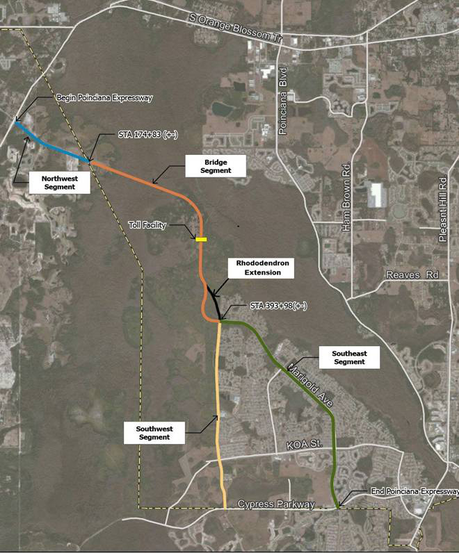
B-1
APPENDIX C
AVATAR CONSTRUCTION PLANS
| Document |
Prepared By | Type | Dated | Approved | Approval Agency | Expiration Date | ||||||
| PP & SR 600 (US 17-92) |
VHB |
Construction Plans |
2/18/09 |
NO |
FDOT |
NA | ||||||
| PP Contract 1 |
VHB |
Construction Plans |
6/19/09 |
10/15/09 |
Polk County |
10/15/16 | ||||||
| PP Contract 2 |
VHB |
Construction Plans |
3/12/08 |
4/30/08 |
Osceola County |
See Note 4 | ||||||
| PP Contract 3 |
VHB |
Construction Plans |
10/14/07 |
10/26/07 |
Osceola County |
See Note 4 | ||||||
| Geotechnical Evaluation |
UES |
8 Reports (See Note 5) |
Various |
NA |
NA |
NA | ||||||
| Environmental Assessments |
UES |
5 Reports (See Note 6) |
Various |
NA |
NA |
NA | ||||||
| Traffic Studies |
LCE |
2 Reports (See Note 7) |
Various |
NA |
NA |
NA | ||||||
| PP-Kinney Harmon Rd |
VHB |
R/W Sketch of Description |
1/15/08 |
NA |
NA |
NA | ||||||
| Poinciana Parkway |
VHB |
R/W Sketch of Description |
1/25/08 |
NA |
NA |
NA | ||||||
| PP-Marigold Ave |
VHB |
R/W Sketch of Description |
1/15/08 |
NA |
NA |
NA |
Notes:
| 1. | VHB-Vanasse Hangen Brustlin, Inc. |
| 2. | UES-Universal Engineering Sciences. |
| 3. | LCE-Leftwich Consulting Engineers, Inc. |
| 4. | Approvals of Contract 2 and Contract 3 Construction Plans run with the Poinciana Parkway Regulatory Agreement (PPRA) and expire upon expiration of the PPRA. |
| 5. | UES Report No.s 409239, 410700, 437336, 490496, 573220, 595455, 573220V2 and 667981. |
| 6. | UES Report No.s 371362, 409238, 619623, 620001 and 646002. |
| 7. | LCE Design Traffic Report (update) dated January 2005 and LCE Design Traffic Report (Supplement) dated September 2005. |
C-1
APPENDIX D
RIGHT-OF-WAY PARCELS
| Parcel No. |
Present Owner |
Transfer To |
Ownership Interest | |||
| P-1 |
Osceola County |
FDOT & Polk County |
Fee Title | |||
| P-1.2 |
Osceola County |
FDOT & Polk County |
Fee Title | |||
| P-1.3E |
Osceola County |
FDOT |
Perm. Easement | |||
| P-2 |
Avatar Properties |
Osceola County |
Fee Title | |||
| P-2A |
Avatar Properties |
Osceola County |
Temp. Easement | |||
| P-2B |
Avatar Properties |
Osceola County |
Temp. Easement | |||
| P-2E |
Avatar Properties |
Osceola County |
Perm. Easement | |||
| P-2.2 |
Avatar Properties |
Osceola County |
Fee Title | |||
| P-3 |
Avatar Properties |
Osceola County |
Fee Title | |||
| P-4 |
Avatar Properties |
Osceola County |
Fee Title | |||
| P-5 |
Avatar Properties |
Osceola County |
Fee Title | |||
| P-6 |
Avatar Properties |
Osceola County |
Fee Title | |||
| P-7 |
Not Used |
NA |
NA | |||
| P-8 |
Avatar Properties |
Osceola County |
Fee Title | |||
| P-9 |
Avatar Properties |
Osceola County |
Fee Title | |||
| P-10 |
Avatar Properties |
Osceola County |
Fee Title | |||
| P-11 |
Avatar Properties |
Osceola County |
Fee Title | |||
| P-12 |
Avatar Properties |
Osceola County |
Fee Title | |||
| P-13 |
Osceola County |
FDOT & Polk County |
Fee Title | |||
| P-13E |
Osceola County |
FDOT |
Perm. Easement | |||
| P-13.1 |
Osceola County |
FDOT |
Fee Title | |||
| P-13.2 |
Osceola County |
FDOT |
Fee Title | |||
| P-13.2E-A |
Osceola County |
FDOT |
Perm. Easement | |||
| P-13.3 |
Osceola County |
FDOT |
Fee Title | |||
| P-13.3E-A |
Osceola County |
FDOT |
Perm. Easement | |||
| P-14 |
Osceola County |
FDOT |
Fee Title | |||
| P-15 |
Osceola County |
FDOT |
Fee Title | |||
| P-15E |
Osceola County |
FDOT |
Perm. Easement | |||
| P-16 |
Osceola County |
FDOT |
Fee Title | |||
| P-17 |
Osceola County |
FDOT |
Fee Title | |||
| P-18 (Bay Street) |
Polk County |
NA |
NA | |||
| P-19 (KH R/W) |
Polk County |
NA |
NA | |||
| P-20 (Not used) |
NA |
NA |
NA | |||
| P-21 |
Avatar Properties |
Osceola County |
Fee Title | |||
| 0-1 |
Avatar Properties |
Osceola County/OCX |
Fee Title | |||
| 0-2 (Not used) |
NA |
NA |
NA | |||
| 0-3 (Not Used) |
NA |
NA |
NA | |||
| 0-4 |
Avatar Properties |
Osceola County/OCX |
Fee Title | |||
| 0-5 |
Avatar Properties |
Osceola County/OCX |
Drainage Easement | |||
| 0-6 |
Avatar Properties |
Osceola County/OCX |
Drainage Easement | |||
| 0-7 |
Avatar Properties |
Osceola County/OCX |
Fee Title |
D-1
| Parcel No. |
Present Owner |
Transfer To |
Ownership Interest | |||
| 0-8 |
Avatar Properties |
Osceola County/OCX |
Fee Title | |||
| 0-9 |
Avatar Properties |
Osceola County/OCX |
Drainage Easement | |||
| 0-10 |
Avatar Properties |
Osceola County/OCX |
Drainage Easement | |||
| Marigold Ave R/W |
Osceola County |
NA |
NA | |||
| 0-11 (Tract A) |
Assoc. of Poinciana Villages |
NA |
NA | |||
| 0-12 |
Avatar Properties |
NA |
NA | |||
| 0-13 |
Avatar Properties |
Osceola County/OCX |
Fee Title | |||
| 0-14 |
Avatar Properties |
Osceola County/OCX |
Fee Title |
Notes:
| 1. | P2E – Permanent easement obtained by Avatar in Polyak transaction. |
| 2. | P2A & 2B – Temporary construction easements obtained by Avatar in Polyak transaction. |
| 3. | See R/W Sketches of Description referenced in Appendix C for location of parcels. |
| 4. | OCX designates Osceola County Expressway Authority. |
D-2
APPENDIX E
PERMIT TRANSFERS
| Type |
Description | Agency | Permit Number | Dated Issued | Expiration Date | |||||
| Federal |
Construction | USACOE | SAJ-2008-2694 (IP-TSB) | Nov. 20, 2008 | June 29, 2019 | |||||
| Regional |
Construction | SFWMD | ERP No. 53-00216-P | Feb. 14, 2008 | Feb. 14, 2018 | |||||
| Regional |
Construction | SFWMD | SGP No. 49-00094-S-6 | Feb. 14, 2008 | Feb. 14, 2018 |
Notes:
| 1. | USACOE – United States Army Corps of Engineers. |
| 2. | SFWMD – South Florida Water Management District. |
| 3. | SFWMD Dewatering permit to be obtained by contracting entity. |
| 4. | Mitigation credits required related to SFWMD ERP No. 53-00216-P, SGP No. 49-00094-S-6, and the deletion of 56.16 acres from the RCMB totaled 49.78 UMAMS. |
| 5. | Mitigation credits required related to SAJ-2008-2694 (IP-TSB) and the deletion of 56.16 acres from RCMB totaled 78.8 Modified Wraps. |
E-1
APPENDIX F
DESIGN CRITERIA
General Design. Poinciana Parkway shall be designed and engineered in accordance with this Appendix F.
(A) Design plans for the Northwest Segment shall be in compliance with Chapter 2 of the Plans Preparation Manual (“PPM”) of the Florida Department of Transportation (“FDOT”) for urban arterial roadways based upon a design speed of 45 miles per hour (“mph”) and a 45 MPH or less posted speed. The Northwest Segment shall initially be designed as a two-lane road with the ability to be expanded to up to four (4) lanes at a future date as determined by the Expressway Authority.
(B) Design plans for the remainder of the Poinciana Parkway from Cypress Parkway up to and including the transition into the Northwest Segment in Polk County shall be in compliance the Chapter 2 of the PPM for a limited access toll road based upon a design speed of 70 mph. Such portion of the Poinciana Parkway shall initially be designed as a two-lane road at a proposed mainline posted speed of 55mph with points of ingress and egress at Cypress Parkway, Koa Road and Marigold Avenue and will include the ability to be expanded to up to six (6) lanes at a future date as determined by the Expressway Authority.
Noise Abatement. Inclusion in the design of noise abatement, if and to the extent required, shall be strictly in accordance with the requirements of the FDOT PD&E Manual in effect as of the effective date of this Development Agreement.
Landscaping and Buffering. The design of landscaping and buffering shall be based on the following:
(A) The total cost of landscaping and buffering of Poinciana Parkway (from U.S. 17- 92 to Cypress Parkway) to be paid by the Expressway Authority from funds made available by Osceola County, Polk County or FDOT shall be subject to a maximum of one and one half percent (1.5%) of the total Poinciana Parkway construction cost.
(B) The design of the landscaping and buffering of Poinciana Parkway shall be in accordance with the FDOT Landscape Guide (1995) and shall be based upon the General Design criteria described above. In addition, the design of landscaping and buffering of the Northwest Segment shall be in accordance with the Polk County Land Development Code (LDC).
(C) All landscaping and buffering improvements for Poinciana Parkway that are to be paid for by the Expressway Authority shall be located within the 300 foot right of way of the Poinciana Parkway.
F-1
DESIGN CRITERIA
POINCIANA PARKWAY / NORTHWEST SEGMENT
FROM US 17/92 TO
OSCEOLA & POLK COUNTY LINE
| Design Element |
Criteria Urban |
Source | Notes | |||||
| General Criteria |
Functional Classification | Principal Arterial | FDOT Green Book Ch. 1 | |||||
| Access Class | Controlled Access-Class 5 | Rules of FDOT, Ch 14-97 | Posted speed 45 mph or less. | |||||
| Number of Through Lanes | 2016-2 min; 2036-4 max. | — | Determined by traffic study. | |||||
| Level of Service | D | — | ||||||
| Design Speed | 45 MPH | FDOT PPM Ch. 2 | See the approved Plans for the design speeds for
the |
Notes:
| 1. | FDOT Green Book-FDOT Manual of Uniform Minimum Standards for Design, Construction, and Maintenance for Streets and Highways, May 2011. |
| 2. | FDOT PPM-Plans Preparation Manual, Volume 1, Revised January 1, 2012. |
| 3. | Refer to FDOT Green Book and FDOT PPM for detailed and additional design criteria. |
| 4. | If a 2 lane roadway is selected for opening year, the 2 lane roadway shall be constructed on the Northern one half of the Right-of-Way. |
F-2
DESIGN CRITERIA
POINCIANA PARKWAY / BRIDGE SEGMENT TO RHODODENDRON EXTENSION,
RHODODENDRON EXTENSION AND SOUTHWEST SEGMENT
| Design Element |
Criteria |
Source | Notes | |||
| Access Class |
Limited Access | FDOT PPM Ch. 1 | Use Interchange spacing of 2 miles measured center to center of crossroads. | |||
| Access Control-2 Lane |
Interchanges & Grade Separations |
Project Design Requirement |
Interchanges shall be located at Marigold Ave. & KOA St. Grade separation shall | |||
| Access Control-4 Lane |
Interchanges & Grade Separations with Frontage Roads |
Project Design Requirement |
Interchanges @ Marigold Ave. & KOA; Grade Separation at CR 580. | |||
| Number of Through Lanes |
2016-2 min; 2036-4 min. | Project Design Requirement |
||||
| Level of Service |
D | — | ||||
| Design Speed |
70 MPH | — | Posted Speed 65 MPH. | |||
| - |
||||||
| Noise Abatement |
Chapter 32 | FDOT PPM Volume 1 | Procedures of FDOT PDE & PPM Manuals shall apply. | |||
| Lighting |
Chapter 7, Section 7.3 | FDOT PPM Volume 1 | Roadway lighting prohibited in and adjacent to RCMB. | |||
| Landscaping |
FDOT “Florida Highway Landscape Guide April 1, 1995” | FDOT PDE Manual & Work Program Instructions |
1.5% of total construction cost. | |||
Notes:
| 1. | FDOT Green Book-FDOT Manual of Uniform Minimum Standards for Design, Construction, and Maintenance for Streets and Highways, May 2011. |
F-3
| 2. | FDOT PPM-Plans Preparation Manual, Volume 1, Revised January 1, 2012. |
| 3. | Refer to FDOT Green Book and FDOT PPM for detailed and additional design criteria. |
| 4. | If a 2-Lane Roadway is selected for opening year, the 2-Lane roadway shall be constructed on the Eastern and Northern one-half of the Right of Way. |
| 5. | Poinciana Parkway shall be elevated over all crossroads, i.e. Marigold Ave. KOA St. and CR580. |
| 6. | The interchanges and grade separation shall be constructed by Osceola County/OCX in both the 2 lane and 4 lane phases of PP. The design and construction costs shall be funded by Osceola County/OCX. |
F-4
APPENDIX G
RIGHT-OF-WAY DEPICTION
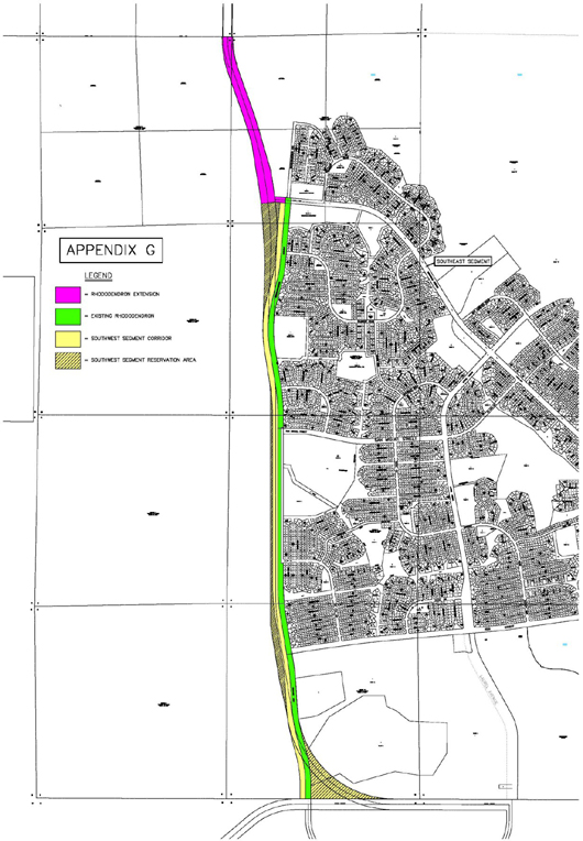
G-1
APPENDIX H
DESCRIPTION OF THE SOUTHWEST SEGMENT CORRIDOR
A parcel of land being a portion of Sections 27 and 34, Township 26 South, Range 28 East and Sections 3 and 10, Township 27 South, Range 28 East, Osceola County, Florida and being more particularly described as follows:
Commence at the Northeast corner of Rhododendron Avenue as shown on the plat of POINCIANA NEIGHBORHOOD 2 SOUTH, VILLAGE 2, as recorded in Plat Book 3, Pages 99 – 108 of the Public Records of Osceola County, Florida; thence run N85°05’34“W along the North line of Rhododendron Avenue, a distance of 150.00 feet, thence run S04°54’26“W along the West Right of Way of said Rhododendron Avenue, a distance of 150.00 feet to the Point of Beginning; thence along the West Right of Way line of Rhododendron Avenue as shown on the plats of POINCIANA NEIGHBORHOOD 2 SOUTH, VILLAGE 2, as recorded in Plat Book 3, Pages 99 – 108 and POINCIANA NEIGHBORHOOD 3, VILLAGE 2, as recorded in Plat Book 3, Pages 109 – 119 and POINCIANA NEIGHBORHOOD 1, VILLAGE 2, as recorded in Plat Book 3, Pages 69 – 87 and POINCIANA NEIGHBORHOOD 5 WEST, VILLAGE 2, as recorded in Plat Book 3, Pages 133 – 143, all of the Public Records of Osceola County, Florida, the following courses and distances; thence run S04°54’26“W, a distance of 1,711.99 feet to the Point of Curvature of a curve, concave to the West, having a Radius of 2,325.00 feet and a Central Angle of 09°32’22”; thence run Southerly along the Arc of said curve, a distance of 387.10 feet (Chord Bearing = S09°40’37“W, Chord = 386.65 feet ) to the Point of Tangency thereof; thence run S14°26’48“W, a distance of 630.28 feet to the Point of Curvature of a curve, concave to the East, having a Radius of 3,375.00 feet and a Central Angle of 23°42’30”; thence run Southerly along the Arc of said curve, a distance of 1,396.54 feet ( Chord Bearing = S02°35’33“W, Chord = 1,386.60 feet ) to the Point of Tangency thereof; thence run S09°15’42“E, a distance of 955.79 feet to the Point of Curvature of a curve, concave to the West, having a Radius of 5,654.58 feet and a Central Angle of 09°15’42”; thence run Southerly along the Arc of said curve, a distance of 914.04 feet ( Chord Bearing = S04°37’51“E, Chord = 913.05 feet ) to the Point of Tangency thereof; thence run S00°00’00“W, a distance of 310.90 feet; thence run S00°00’06“E, a distance of 2,465.27 feet; thence run S00°00’24“W, a distance of 1,893.03 feet to the Point of Curvature of a curve, concave to the East, having a Radius of 5,804.58 feet and a Central Angle of 09°17’45”; thence run Southerly along the Arc of said curve, a distance of 941.76 feet ( Chord Bearing = S04°38’29“E, Chord = 940.73 feet ) to the Point of Tangency thereof; thence run S09°17’21“E, a distance of 1,325.57 feet to the Point of Curvature of a curve, concave to the West, having a Radius of 4,925.00 feet and a Central Angle of 05°52’48”; thence run Southerly along the Arc of said curve, a distance of 505.43 feet ( Chord Bearing = S06°20’57“E, Chord = 505.21 feet ) to the Point of Tangency thereof; thence run S03°24’33“E, a distance of 612.26 feet to the Point of Curvature of a curve, concave to the East, having a Radius of 4,575.00 feet and a Central Angle of 11°47’02”; thence run Southerly along the Arc of said curve, a distance of 940.93 feet ( Chord Bearing = S09°18’04“E, Chord = 939.27 feet ) to the Point of Tangency thereof; thence run S15°11’34“E, a distance of 438.73 feet to the Point of Curvature of a curve, concave to the West, having a Radius of 3,425.00 feet and a Central Angle of 15°17’30”; thence run Southerly along the Arc of said curve, a distance of 914.10 feet ( Chord Bearing = S07°32’49“E, Chord = 911.39 feet ) to the
H-1
Point of Tangency thereof; thence run S00°05’57“W, a distance of 337.63 feet to the Point of Curvature of a curve, concave to the Northwest, having a Radius of 25.00 feet and a Central Angle of 90°00’02”; thence run Southwesterly along the Arc of said curve, a distance of 39.27 feet ( Chord Bearing = S45°05’55“W, Chord = 35.35 feet ) to a point on the North Right of Way line of Cypress Parkway and the South line of Osceola County; thence run N89°54’01“W along said North Right of Way line, a distance of 125.00 feet; thence departing said North Right of Way line, run Northerly along a line lying 150.00 feet West of, and parallel with, the aforesaid West Right of Way line of Rhododendron Avenue, the following courses and distances; run N00°05’57“E, a distance of 362.61 feet to a point on a non-tangent curve, concave to the West, having a Radius of 3,275.00 feet and a Central Angle of 15°17’32”; thence run Northerly along the Arc of said curve, a distance of 874.09 feet ( Chord Bearing = N07°32’49“W, Chord = 871.50 feet ) to the Point of Tangency thereof; thence run N15°11’34“W, a distance of 438.78 feet to a point on a non-tangent curve, concave to the East, having a Radius of 4,725.00 feet and a Central Angle of 11°47’00”; thence run Northerly along the Arc of said curve, a distance of 971.73 feet ( Chord Bearing = N09°18’03“W, Chord = 970.02 feet ) to the Point of Tangency thereof; thence run N03°24’33“W, a distance of 612.26 feet to the Point of Curvature of a curve, concave to the West, having a Radius of 4,775.00 feet and a Central Angle of 05°52’48”; thence run Northerly along the Arc of said curve, a distance of 490.04 feet ( Chord Bearing = N06°20’57“W, Chord = 489.82 feet ) to the Point of Tangency thereof; thence run N09°17’21“W, a distance of 1,325.57 feet to the Point of Curvature of a curve, concave to the East, having a Radius of 5,954.58 feet and a Central Angle of 09°17’45”; thence run Northerly along the Arc of said curve, a distance of 966.10 feet ( Chord Bearing = N04°38’29“W, Chord = 965.04 feet ); thence run N00°00’24“E, a distance of 1,893.01 feet to the Point of Tangency thereof; thence run N00°00’06“W, a distance of 2,465.27 feet; thence run N00°00’00“E, a distance of 310.90 feet to the Point of Curvature of a curve, concave to the West, having a Radius of 5,504.58 feet and a Central Angle of 09°15’42”; thence run Northerly along the Arc of said curve, a distance of 889.80 feet ( Chord Bearing = N04°37’51“W, Chord = 888.83 feet ) to the Point of Tangency thereof; thence run N09°15’42“W, a distance of 955.79 feet to the Point of Curvature of a curve, concave to the East, having a Radius of 3,525.00 feet and a Central Angle of 23°42’30”; thence run Northerly along the Arc of said curve, a distance of 1,458.60 feet ( Chord Bearing = N02°35’33“E, Chord = 1,448.22 feet ) to the Point of Tangency thereof; thence run N14°26’48“E, a distance of 630.28 feet to the Point of Curvature of a curve, concave to the West, having a Radius of 2,175.00 feet and a Central Angle of 09°32’22”; thence run Northerly along the Arc of said curve, a distance of 362.13 feet ( Chord Bearing = N09°40’37“E, Chord = 361.71 feet ) to the Point of Tangency thereof; thence run N04°54’26“E, a distance of 1,711.99 feet to a point on the Westerly extension of the South Right of Way line of Marigold Avenue; thence run S85°05’34“E along said line, a distance of 150.00 feet to the Point of Beginning.
Containing 57.548 acres, more or less.
H-2
APPENDIX I
DESCRIPTION OF THE RHODODENDRON EXTENSION CORRIDOR
A parcel of land being a portion of Sections 27 and 28, Township 26 South, Range 28 East, Osceola County, Florida and being more particularly described as follows:
Commence at the Northeast corner of Rhododendron Avenue as shown on the plat of POINCIANA NEIGHBORHOOD 2 SOUTH, VILLAGE 2, as recorded in Plat Book 3, Pages 99 – 108 of the Public Records of Osceola County, Florida; thence run N85°05’34“W along the North line of Rhododendron Avenue, a distance of 150.00 feet, to the Point of Beginning; thence run S04°54’26“W along the West Right of Way of said Rhododendron Avenue, a distance of 150.00 feet; thence departing said West Right of Way line, run N85°05’34“W, a distance of 278.39 feet; thence run S83°41’57“W, a distance of 400.00 feet to a point on a non-tangent curve, concave to the West, having a Radius of 11,259.00 feet and a Central Angle of 04°32’03”; thence run Northerly along the Arc of said curve, a distance of 890.97 feet ( Chord Bearing = N08°34’04“W, Chord = 890.73 feet ) to a point; thence run N09°06’42“W, a distance of 776.34 feet to a point on a non-tangent curve, concave to the West, having a Radius of 11,309.00 feet and a Central Angle of 04°43’09”; thence run Northerly along the Arc of said curve, a distance of 931.45 feet ( Chord Bearing = N17°07’44“W, Chord = 931.18 feet ) to a point; thence run N19°29’18“W, a distance of 1,140.86 feet to the Point of Curvature of a curve, concave to the East, having a Radius of 3,015.00 feet and a Central Angle of 20°02’32”; thence run Northerly along the Arc of said curve, a distance of 1,054.65 feet ( Chord Bearing = N09°28’03“W, Chord = 1,049.28 feet ) to a point on the North line of said Section 28; thence run S89°50’06“E along said North line, a distance of 270.00 feet to the Northeast corner of said Section 28 and the Northwest corner of said Section 27; thence run N88°46’49“E along the North line of said Section 27, a distance of 30.02 feet to a point on a non-tangent curve, concave to the East, having a Radius of 2,715.00 feet and a Central Angle of 20°06’01”; thence run Southerly along the Arc of said curve, a distance of 952.47 feet ( Chord Bearing = S09°26’18“E, Chord = 947.60 feet ) to the Point of Tangency thereof; thence run S19°29’18“E, a distance of 1,140.86 feet to a point on a non-tangent curve, concave to the West, having a Radius of 11,609.00 feet and a Central Angle of 04°43’09”; thence run Southerly along the Arc of said curve, a distance of 956.15 feet ( Chord Bearing = S17°07’44“E, Chord = 955.88 feet ) to a point; thence run S16°22’55“E, a distance of 800.32 feet to a point on a non-tangent curve, concave to the West, having a Radius of 11,659.00 feet and a Central Angle of 03°46’54”; thence run Southerly along the Arc of said curve, a distance of 769.50 feet ( Chord Bearing = S08°56’39“E, Chord = 769.36 feet ) to a point; thence run S85°05’34“E, a distance of 309.14 feet to the Point of Beginning.
Containing 36.922 acres, more or less.
I-1
APPENDIX J
DESCRIPTION OF THE SOUTHWEST SEGMENT RESERVATION AREA
A parcel of land being a portion of Sections 27 and 34, Township 26 South, Range 28 East and Sections 3 and 10, Township 27 South, Range 28 East, Osceola County, Florida and being more particularly described as follows:
Commence at the Northeast corner of Rhododendron Avenue as shown on the plat of POINCIANA NEIGHBORHOOD 2 SOUTH, VILLAGE 2, as recorded in Plat Book 3, Pages 99 – 108 of the Public Records of Osceola County, Florida;
thence run N85°05’34“W along the North line of Rhododendron Avenue, a distance of 150.00 feet to a point on the West Right of Way line of said Rhododendron Avenue, thence run S04°54’26“W along said West Right of Way, a distance of 150.00 feet to point on the Westerly extension of the South Right of Way line of Marigold Avenue; thence run N85°05’34“W along said line, a distance of 150.00 feet to the Point of Beginning; thence run Southerly along a line lying 150.00 feet West of and parallel with the West Right of Way line of said Rhododendron Avenue the following courses and distances; thence run S04°54’26“W, a distance of 1,711.99 feet to the Point of Curvature of a curve, concave to the West, having a Radius of 2,175.00 feet and a Central Angle of 09°32’22”; thence run Southerly along the Arc of said curve, a distance of 362.13 feet ( Chord Bearing = S09°40’37“W, Chord = 361.71 feet ) to the Point of Tangency thereof; thence run S14°26’48“W, a distance of 630.28 feet to the Point of Curvature of a curve, concave to the East, having a Radius of 3,525.00 feet and a Central Angle of 12°31’08”; thence run Southerly along the Arc of said curve, a distance of 770.20 feet ( Chord Bearing = S08°11’14“W, Chord = 768.67 feet ) to a point; thence departing said line, run N01°55’40“E, a distance of 1,785.47 feet; thence run N03°29’12“W, a distance of 965.52 feet to a point on a non- tangent curve, concave to the West, having a Radius of 11,259.00 feet and a Central Angle of 03°19’52”; thence run Northerly along the Arc of said curve, a distance of 654.59 feet ( Chord Bearing = N04°38’07“W, Chord = 654.49 feet ) to a point; thence run N83°41’57“E, a distance of 400.00 feet; thence run S85°05’34“E, a distance of 128.39 feet to the Point of Beginning.
Containing 19.883 acres, more or less.
Together with
A parcel of land being a portion of Sections 27 and 34, Township 26 South, Range 28 East and Sections 3 and 10, Township 27 South, Range 28 East, Osceola County, Florida and being more particularly described as follows:
Commence at the Northeast corner of Rhododendron Avenue as shown on the plat of POINCIANA NEIGHBORHOOD 2 SOUTH, VILLAGE 2, as recorded in Plat Book 3, Pages 99 – 108 of the Public Records of Osceola County, Florida;
thence along the East Right of Way line of Rhododendron Avenue, the following courses and distances; thence run S04°54’26“W, a distance of 1,861.99 feet to the Point of Curvature of a curve, concave to the West, having a Radius of 2,475.00 feet and a Central Angle of 09°32’22”; thence run Southerly along the Arc of said curve, a distance of 412.08 feet ( Chord Bearing =
J-1
S09°40’37“W, Chord = 411.60 feet ) to the Point of Tangency thereof; thence run S14°26’48“W, a distance of 630.28 feet to the Point of Curvature of a curve, concave to the East, having a Radius of 3,225.00 feet and a Central Angle of 23°42’30”; thence run Southerly along the Arc of said curve, a distance of 1,334.47 feet ( Chord Bearing = S02°35’33“W, Chord = 1,324.97 feet ) to the Point of Tangency thereof; thence run S09°15’42“E, a distance of 808.76 feet to a point; thence departing said East Right of Way line, run S80°44’18“W, a distance of 300.00 feet to the Point of Beginning; thence run Southerly along a line lying 150.00 feet West of and parallel with the West Right of Way line of said Rhododendron Avenue the following courses and distances; thence run S09°15’42“E, a distance of 147.03 feet to the Point of Curvature of a curve, concave to the West, having a Radius of 5,504.58 feet and a Central Angle of 09°15’42”; thence run Southerly along the Arc of said curve, a distance of 889.80 feet ( Chord Bearing = S04°37’51“E, Chord = 888.83 feet ) to the Point of Tangency thereof; thence run S00°00’00“W, a distance of 310.90 feet; thence run S00°00’06“E, a distance of 2,465.27 feet; thence run S00°00’24“W, a distance of 1,893.01 feet to the Point of Curvature of a curve, concave to the East, having a Radius of 5,954.58 feet and a Central Angle of 09°17’45”; thence run Southerly along the Arc of said curve, a distance of 966.10 feet ( Chord Bearing = S04°38’29“E, Chord = 965.04 feet ) to the Point of Tangency thereof; thence run S09°17’21“E, a distance of 1,325.57 feet to the Point of Curvature of a curve, concave to the West, having a Radius of 4,775.00 feet and a Central Angle of 05°52’48”; thence run Southerly along the Arc of said curve, a distance of 490.04 feet ( Chord Bearing = S06°20’57“E, Chord = 489.82 feet ) to the Point of Tangency thereof; thence run S03°24’33“E, a distance of 612.26 feet to the Point of Curvature of a curve, concave to the East, having a Radius of 4,725.00 feet and a Central Angle of 05°13’11”; thence run Southerly along the Arc of said curve, a distance of 430.46 feet ( Chord Bearing = S06°01’09“E, Chord = 430.31 feet ) to a point on a non-tangent curve, concave to the East, having a Radius of 3,015.00 feet and a Central Angle of 00°51’25”; thence departing said line, run Northerly along the Arc of said curve, a distance of 45.09 feet ( Chord Bearing = N09°43’04“W, Chord = 45.09 feet ) to a point; thence run N09°17’21“W, a distance of 247.47 feet; thence run N12°52’38“W, a distance of 802.37 feet; thence run N09°18’04“W, a distance of 1,618.07 feet; thence run N00°00’24“E, a distance of 3,021.34 feet; thence run N00°00’06“W, a distance of 3,370.33 feet to the Point of Curvature of a curve, concave to the West, having a Radius of 2,715.00 feet and a Central Angle of 09°15’36”; thence run Northerly along the Arc of said curve, a distance of 438.80 feet ( Chord Bearing = N04°37’54“W, Chord = 438.32 feet ) to the Point of Beginning.
Containing 17.083 acres, more or less.
Together with
A parcel of land being a portion of Tract A and Tract B, POINCIANA NEIGHBORHOOD 5 WEST, VILLAGE 2, as recorded in Plat Book 3, Pages 133 – 143, all of the Public Records of Osceola County, Florida and being more particularly described as follows:
Begin at the Southwest corner of Tract B as shown on said plat of POINCIANA NEIGHBORHOOD 5 WEST, VILLAGE 2, said point being the intersection of the North Right of Way line of Cypress Parkway and the East Right of Way line of Rhododendron Avenue as shown on the said plat of POINCIANA NEIGHBORHOOD 5 WEST, VILLAGE 2, said point
J-2
being a point on a curve, concave to the Northeast, having a Radius of 25.00 feet and a Central Angle of 89°59’58”; thence along the East Right of Way line of Rhododendron Avenue the following four (4) courses and distances; thence run Northwesterly along the Arc of said curve a distance of 39.27 feet ( Chord Bearing = N44°54’02“W, Chord = 36.36 feet ) to the Point of Tangency thereof; thence run N00°05’57“E, a distance of 337.58 feet to the Point of Curvature of a curve, concave to the West, having a Radius of 3,575.00 feet and a Central Angle of 15°17’32”; thence run Northerly along the Arc of said curve, a distance of 954.16 feet ( Chord Bearing = N07°32’49“W, Chord = 951.33 feet ) to the Point of Tangency thereof; thence run N15°11’34“W, a distance of 438.78 feet to the Point of Curvature of a curve, concave to the East, having a Radius of 4,425.00 feet and a Central Angle of 06°36’56”; thence run Northerly along the Arc of said curve, a distance of 510.92 feet ( Chord Bearing = N11°53’05“W, Chord = 510.64 feet ) to a point on a non-tangent curve, concave to the Northeast, having a Radius of 2,715.00 feet and a Central Angle of 79°40’16”; thence departing said East Right of Way line, run Southeasterly along the Arc of said curve, a distance of 3,775.27 feet ( Chord Bearing = S50°03’53“E, Chord = 3,478.38 feet ) to a point on the South line of said Tract B and also a point on the aforesaid North Right of Way line of Cypress Parkway; thence run N89°54’01“W along said North Right of Way line, a distance of 2,297.66 feet to the Point of Beginning.
Containing 22.222 acres, more or less.
J-3
APPENDIX K
DEPICTION OF CONCURRENCY RIGHT-OF-WAY
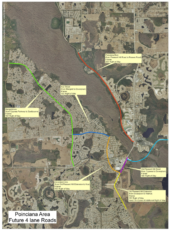
K-1

K-2
APPENDIX L
UNFULFILLED OBLIGATIONS
| Agreement/ Permit |
Permit No. /Date |
Pre Construction |
Construction |
Post Construction | ||||
| Gamlex Agreement | Dec. 15, 2006 | None | See Agreement | None | ||||
| Polyak Agreement | Dec. 16, 2006 | None | See Agreement | None | ||||
| AE7/RCMB Agreement | May 8, 2007 | See Agreement & | See Agreement & | See Agreement & | ||||
| AE7/RCMB 1st Amend. | Dec. 8, 2010 | Closing Documents See Agreement |
Closing Documents See Agreement |
Closing Documents See Agreement | ||||
| ABD | OT&FJ | None | See OT | None | ||||
| BYRD | FJ | None | See FJ | None | ||||
| Telestat | FJ | None | See FJ | None | ||||
| Bercini | FJ | None | See FJ | None |
Notes:
| 1. | ABD, Byrd, Telestat and Bercini are eminent domain acquisitions by Osceola County. |
| 2. | Gamlex, Polyak and AE7/RCMB are acquisition agreements with Avatar Properties Inc. |
| 3. | OT designates Order of Taking. |
| 4. | FJ designates Final Judgment. |
| 5. | The unfilled obligations listed herein specifically exclude all public and private Utility Adjustments and Relocations since neither final verbal nor written agreements have been made or entered into by Avatar Properties Inc. with the applicable utility providers. |
L-1
APPENDIX M
DRAINAGE FACILITIES AND PONDS
| Location |
Description |
R/W Parcel |
Conveyance |
Recipient | ||||
| PP Contract 2 |
Pond 3 | 0-5 | Drainage Easement | Osceola County/OCX | ||||
| PP Contract 2 |
Pond 4 | 0-6 | Drainage Easement | Osceola County/OCX | ||||
| PP Contract 2 |
Pond 5 | 0-9 | Drainage Easement | Osceola County/OCX | ||||
| PP Contract 2 |
Pond 6 | 0-10 | Drainage Easement | Osceola County/OCX | ||||
| PP Contract 3 |
Pond 7 | 0-11 | None | N/A | ||||
| PP Contract 3 SW Segment |
Pond 8 TBD |
0-12 TBD |
None Drainage Easement |
N/A Osceola County/OCX |
Notes:
| 1. | PP Contract 2 & 3 – Poinciana Parkway Contract 2 & 3, see Appendix C. |
| 2. | R/W Parcel – Refer to R/W sketches of description references in Appendix C. |
| 3. | SW Segment – See Article 1, Definitions and Interpretation. |
| 4. | OCX designates Osceola County Expressway Authority. |
| 5. | TBD-To be determined. |
| 6. | N/A – Not applicable. |
| 7. | R/W Parcels 0-5, 0-6, 0-9 and 0-10 identified above are shared drainage facilities as designed and permitted for the Bridge Segment of the 9.66 mile Poinciana Parkway project. |
| 8. | R/W Parcels 0-11 & 0-12 identified above are shared drainage facilities as designed and permitted for the Southeast Segment of the 9.66 mile Poinciana Parkway Project. |
M-1
APPENDIX N
FORM OF STORMWATER DRAINAGE, CONSTRUCTION
AND MAINTENANCE EASEMENT AGREEMENT
RECORD AND RETURN TO:
Robert W. Bowser, Esq.
Greenberg Traurig, P.A.
450 South Orange Avenue, Suite 650
Orlando, Florida 32801
STORMWATER DRAINAGE, CONSTRUCTION AND MAINTENANCE EASEMENT
AGREEMENT
THIS STORMWATER DRAINAGE, CONSTRUCTION AND MAINTENANCE EASEMENT AGREEMENT (“Easement Agreement”) is made and entered into this date of , 2012 (“Effective Date”), by and between AVATAR PROPERTIES INC., a Florida corporation (“Grantor”) and OSCEOLA COUNTY, a political subdivision of the State of Florida (“Grantee”) (Grantor and Grantee are sometimes together referred to herein as the “Parties”, and separately as a “Party”).
WITNESSETH:
WHEREAS, Grantor is the owner in fee simple of that certain real property located in Osceola County, Florida, more particularly described on Exhibit “A” attached hereto and by this reference incorporated herein (the “Easement Area”); and
WHEREAS, Grantee intends to construct Poinciana Parkway, an approximately 9.66 mile controlled access road beginning at the existing intersection of County Road 54 and US 17-92 in Polk County, Florida, and terminating in Osceola County, Florida, at Cypress Parkway (CR 580) (the “Project”), pursuant to and further described in that certain Agreement for Development of Poinciana Parkway entered into by and between the Grantor, Grantee, Osceola County Expressway Authority and Polk County dated the day of , 2012 (the “Development Agreement”); and
WHEREAS, all construction of improvements upon the Easement Area shall be in accordance with and pursuant to the construction plans and permits described in the Development Agreement (which construction plans and permits, as may be from time to time amended, are hereinafter the “Construction Plans” and “Permits”); and
WHEREAS, in order to complete the Project pursuant to and in accordance with the terms of the Construction Plans and Permits, Grantee requires a perpetual non-exclusive
N-1
easement upon, over, across, through, and into the Easement Area for stormwater management purposes; and
WHEREAS, Grantor desires to grant to Grantee a perpetual non-exclusive easement upon, under, across, through and into the Easement Area for stormwater detention and retention and outfall purposes for the Project and for the construction and maintenance of those improvements required by the Construction Plans and Permits for stormwater management purposes within the Easement Area (“Grantee Improvements”), but only as more specifically set forth herein and subject to the terms and conditions set forth herein.
NOW, THEREFORE, for and in consideration of the mutual covenants and agreements herein set forth and other good and valuable consideration, the receipt, adequacy and sufficiency of which are hereby expressly acknowledged by the Parties, the Parties do hereby agree as follows:
1. Recitals. The foregoing recitals are true and correct and are incorporated herein by this reference.
2. Power and Authority of Grantor. The Grantor hereby represents and warrants that it has the full right, power and authority to enter into, deliver and perform this Easement Agreement.
3. Grant of Perpetual Stormwater Drainage, Construction and Maintenance Easement. Grantor hereby grants to Grantee a perpetual, nonexclusive easement upon, over, across, through and into the Easement Area for stormwater detention and retention and outfall purposes for stormwater drainage resulting from the Project, and for the construction and maintenance of the Grantee Improvements in a manner pursuant to, in accordance with and consistent with the Construction Plans and Permits (“Easement”). The Easement shall run with the title to the Easement Area and be binding upon the Grantor and its successors in title to the Easement Area and assigns and is hereby granted to Grantee subject to all matters of record in the Public Records of Osceola County, Florida. The Grantee hereby acknowledges that use of the Easement Area shall be shared by the Grantee with Grantor, Grantor’s successors and assigns and hereby agrees the volume of stormwater detention and retention from the Project shall not exceed the amount sufficient to accommodate the Project, as specified in the Permits.
4. Construction of Grantee Improvements. Grantee shall be responsible, at Grantee’s sole cost and expense, for the engineering, design, permitting, excavation, construction and installation of any and all Grantee Improvements, as well as any proposed modification by Grantee thereto. Notwithstanding the foregoing, the Parties acknowledge that the Construction Plans and Permits related to the Easement Area are deemed approved by the Parties hereto and any and all other governmental agencies having jurisdiction thereto and final as of the Effective Date hereof and require no further review or approval by Grantor. Grantor shall have the right to review and approve and Grantor shall be provided with copies of final Construction Plans and Permits related to the Easement Area for any proposed modification to the Grantee Improvements. Grantee shall not modify the Permits related to the Easement Area without the consent of Grantor. In no event shall construction of any such modification commence until the applicable final construction plans are approved by Grantor or such approval has been waived in
N-2
writing. Upon receipt of any construction plans relating to any modification of the Grantee Improvements, Grantor shall have a period of fifteen (15) days to review said plans and notify Grantee of any deficiencies therein which must be corrected prior to Grantor’s approval thereof. In the event such plans are not approved and the Grantee is notified of deficiencies within the time required, then Grantor shall have an additional fifteen (15) day period to review any revised plans submitted and to notify Grantee of any further deficiencies. Notwithstanding anything to the contrary hereinabove, in the event Grantor fails to deliver to the Grantee a notice of such deficiencies within such fifteen (15) day period, the plans will be deemed approved. Grantor hereby covenants and agrees that Grantee is entitled to the use of the fill dirt excavated from the Easement Area in connection with the preparation, excavation, construction or installation of the Grantee Improvements (“Fill”) in the amount required for the construction of the Project in a manner pursuant to, in accordance with and consistent with the Construction Plans and Permits (“Required Fill”). In the event that the amount of Fill removed from the Easement Area is in excess of the Required Fill, such Fill shall be deemed “Excess Fill” and shall be the sole and exclusive property of Grantor. All Excess Fill shall be deposited at Grantee’s sole cost and expense and at Grantor’s direction on property owned by Grantor adjacent to or in the vicinity of the Project.
5. Maintenance of Easement Area. Grantee shall maintain the Easement Area and the Grantee Improvements thereupon in good order and repair in accordance with the Construction Plans and Permits and the land development code of the Osceola County, Florida. In the event any required maintenance hereunder is not performed by Grantee in accordance with the foregoing standards, Grantor may deliver a notice to Grantee setting forth the maintenance deficiencies, whereupon Grantee, shall have a period of fifteen (15) days to remedy the deficiencies, or forty-eight (48) hours, in case of emergency. In the event the deficiencies are not remedied in a commercially reasonable fashion within such fifteen (15) day period, or within such forty-eight (48) hour period in case of emergency, Grantor shall have the right to undertake all reasonably necessary maintenance and repair itself and recover from Grantee the fees, costs and expenses incurred in connection therewith.
Notwithstanding anything herein to the contrary and without limitation of any other rights reserved herein, Grantor, for itself and its successors and assigns, hereby reserves the right to erect and install aesthetic development features such as but not limited to landscaping, berms, lighting, screening, fountains, and other features (“Grantor Improvements”) deemed desirable by Grantor over and upon the Easement Area without any requirement for permission or approval by the Grantee, provided, however, that any such Grantor Improvements shall not impair Grantee’s use and maintenance of the Easement Area as contemplated in this Easement Agreement for the purposes set forth herein in the management of stormwater from the Project. All maintenance, repair and replacement of such Grantor Improvements shall be at the sole cost and expense of Grantor; provided, however, in the event that Grantee undertakes any maintenance, repair or replacement within the Easement Area as otherwise required under this Easement Agreement then Grantee shall undertake such maintenance, repair or replacement in such fashion and with such due care as may be necessary to minimize any disturbance of any Grantor Improvements and Grantee shall be responsible for any damage or disturbance caused to the Grantor Improvements in connection therewith.
N-3
6. Obligations of the Parties. The Parties acknowledge and agree that any rights granted hereunder shall be exercised by the Parties only in accordance and compliance with any and all applicable laws, ordinances, rules, regulations, permits and approvals, including but not limited to the Construction Plans and Permits and any future modifications or amendments thereto. The Parties covenant and agree that neither party shall discharge into or within the Easement Area any hazardous or toxic materials or substances, any pollutants, or any other substances or materials prohibited or regulated under any federal, state or local law, ordinance, rule, regulations or permit, except in accordance with such laws, ordinances, rules, regulations and permits.
7. Remedies and Insurance.
(i) In the event of a default hereunder, all parties shall have all rights and remedies allowed by law in connection therewith, including, without limitation, the right to specific performance, subject, however, to notice and right to cure as set forth in the Development Agreement and any other limitation expressly set forth therein. No party shall be in default hereunder unless the other party alleging a default shall have given the party against whom a default is alleged not less than thirty days prior written notice thereof, unless a longer or shorter time for particular matters is set forth in the Development Agreement, in which case such longer or shorter time shall apply, and opportunity to cure, without cure having been effected. In any action at law or in equity between the parties hereto occasioned by a default hereunder, the prevailing party shall be entitled to collect its reasonable attorneys’ fees actually incurred in the action from the non-prevailing party. As used herein, the term “prevailing party” shall mean the party who receives substantially the relief sought. If the prevailing party utilizes “in-house” counsel, such party’s reasonable costs, expenses and overhead for the time expended by the prevailing party for such in-house counsel in the aforementioned action shall be recoverable by the prevailing party in the same manner as other attorneys’ fees. Each party hereby knowingly, voluntarily and intentionally waives the right to a trial by jury with respect to any litigation (including but not limited to any counterclaims, cross claims or third party claims), whether now existing or hereafter arising, and whether sounding in contract, tort, equity or otherwise, regardless of the cause or causes of action, defenses or counterclaims alleged or the relief sought by any party, and regardless of whether such causes of action, defenses or counterclaims are based on, or arise out of, under or in connection with this Easement Agreement or its subject matter, out of any alleged conduct or course of conduct, dealing or course of dealing, statement (whether verbal or written), or otherwise.
(ii) Grantor and Grantee hereby covenant and agree that each said Party shall maintain, at its own expense, or cause its contractor to maintain, during the period of any of its construction and maintenance activities contemplated hereunder comprehensive liability insurance underwritten by an insurance carrier with a Best rating equal to or better than A in an amount no less than $1,000,000.00 per occurrence for personal injury (including death) and $1,000,000.00 per occurrence for property damage, which policy or policies shall name the other Party hereto as additional insured parties.
8. Limited Public Dedication. Nothing contained in this Easement Agreement shall create or shall be deemed to create any easements or use rights in the general public or constitute a public dedication beyond the rights of the public set forth herein. Dedication of
N-4
rights granted herein shall be strictly limited to stormwater detention and retention and outfall purposes from the Project.
9. Beneficiaries of Easement Rights. The Easement set forth in this Easement Agreement shall be for the benefit and use of Grantee, Grantor and their successors in title and assigns, and their agents, employees, consultants, representatives, contractors (and their subcontractors, employees and materialmen), licensees, guests, invitees and providers of emergency services.
10. Amendments and Waivers. This Easement Agreement may not be terminated or amended, modified, altered, or changed in any respect whatsoever, except by a further agreement in writing duly executed by the Parties, or successor(s) in title, and recorded in the Public Records of Osceola County, Florida. No delay or omission of any Party in the exercise of any right accruing upon any default of any Party shall impair such right or be construed to be a waiver thereof, and every such right may be exercised at any time during the continuance of such default. A waiver by any Party of a breach of, or a default in, any of the terms and conditions of this Easement Agreement by any other Party shall not be construed to be a waiver of any subsequent breach of or default in the same or any other provision of this Easement Agreement. No breach of the provisions of this Easement Agreement shall entitle any Party to cancel, rescind or otherwise terminate this Easement Agreement, but such limitation shall not affect, in any manner, any other rights or remedies which any Party may have by reason of any breach of the provisions of this Easement Agreement.
11. Notices. Notices hereunder shall be given to the Parties set forth below and shall be made by hand delivery, facsimile, or overnight delivery. For the purpose of calculating time limits which run from the giving of a particular notice the time shall be calculated from actual receipt of the notice. Time limits shall expire only on business days which, for purposes of this Easement Agreement shall be any day other than a Saturday, Sunday or legal Osceola County public holiday. Notices shall be addressed as follows:
| If to Grantor: |
Avatar Properties Inc. | |
| 395 Village Drive | ||
| Kissimmee, Florida 34759 | ||
| Phone: (863) 427-7098 | ||
| Attention: PK Fletcher, Esquire | ||
| E-mail: PK.Fletcher@avhomesinc.com | ||
| With copies to: |
Avatar Properties Inc. | |
| 395 Village Drive | ||
| Kissimmee, Florida 34759 | ||
| Phone: (863) 427-7214 | ||
| Attention: Tony Iorio | ||
| E-mail: T.Iorio@avhomesinc.com | ||
N-5
| And: |
Greenberg Traurig, P.A. |
|||
| 450 South Orange Avenue, Suite 650 |
||||
| Orlando, Florida 32801 |
||||
| Phone: (407) 418-2417 |
||||
| Fax: (407) 420-5909 |
||||
| Attention: Julie P. Kendig-Schrader, Esq. |
||||
| Email: Kendig@gtlaw.com |
||||
| If to Grantee: |
Attention: Atlee Mercer |
|||
|
|
||||
|
|
||||
|
|
||||
| With copy to: |
Broad & Cassel |
|||
| 390 North Orange Avenue |
||||
| Suite 1400 |
||||
| Orlando, Florida 32801-4961 |
||||
| Phone: (407) 839-4200 |
||||
| Fax: (407) 839-4210 |
||||
| Attention: Joseph Stanton, Partner |
||||
| E-mail: jstanton@broadandcassel.com |
||||
| If to County: |
Osceola County |
|||
| Attn: Don Fisher, County Manager |
||||
| 1 Courthouse Square |
||||
| Kissimmee, Florida 34741 |
||||
| Fax: (407) 742-2391 |
||||
| E-mail: dfis@osceola.org |
||||
| With copy to: |
Osceola County |
|||
| Attn: Andrew Mai, County Attorney |
||||
| 1 Courthouse Square |
||||
| Kissimmee, Florida 34741 |
||||
| Fax: (407) 742-2217 |
||||
| E-mail: andrew.mai@osceola.org |
||||
12. Reservation of Rights. It is acknowledged and agreed that the Easement granted under this Easement Agreement is not an exclusive easement and that Grantor, its successors and assigns, shall have the right to use and enjoy the Easement Area in any manner not inconsistent with the easement rights created herein, including but not limited to (i) the right to drain stormwater from other property owned by Grantor, its successors and assigns, into the Grantee Improvements and Easement Area; (ii) and the right to relocate, expand or modify the Easement Area, at Grantor’s expense, in connection with the development, use and enjoyment of the property adjacent to or in the vicinity of the Easement Area. Grantor acknowledges that any increase in the cost of maintaining the Easement Area and/or the Grantee Improvements located therein incurred as a result of Grantor’s aforesaid use, relocation, expansion or modification shall
N-6
be borne by Grantor, including the costs of modification or obtaining of any new or additional permits required from any governmental authority in connection therewith. Grantor further acknowledges and agrees that (a) no relocation, expansion or modification shall diminish the capacity or function provided by the Easement Area to the Grantee; (b) the relocation or modification shall be accomplished in a manner that does not impair the functions or capacity of the Easement Area during the relocation or modification; and (c) Grantor shall provide Grantee written notice prior to exercising Grantor’s rights under subsection (ii) above.
13. Miscellaneous. Except for the terms and conditions set forth in Development Agreement, Construction Plans and Permits this Easement Agreement contains the entire understanding of the Parties with respect to the matters set forth herein and no other agreement, oral or written, not set forth herein, nor any course of dealings of the Parties, shall be deemed to alter or affect the terms and conditions set forth herein. If any provision of this Easement Agreement, or portion thereof, or the application thereof to any person or circumstances, shall, to the extent be held invalid, inoperative or unenforceable, the remainder of this Easement Agreement, or the application of such provision or portion thereof to any other persons or circumstances, shall not be affected thereby; it shall not be deemed that any such invalid provision affects the consideration for this Easement Agreement; and each provision of this Easement Agreement shall be valid and enforceable to the fullest extent permitted by law. This Easement Agreement shall be construed in accordance with the laws of the State of Florida. Venue for any proceeding brought hereunder shall be Osceola County, Florida. In the event of any dispute hereunder or of any action to interpret or enforce this Easement Agreement, any provision hereof or any matter arising herefrom, the prevailing party shall be entitled to recover its reasonable attorneys’ fees, paralegals’ fees or experts’ fees costs and expenses, whether suit be brought or not, and whether in settlement, in any declaratory action, at trial or on appeal. The section headings in this Easement Agreement are for convenience only, shall in no way define or limit the scope or content of this Easement Agreement, and shall not be considered in any construction or interpretation of this Easement Agreement or any part hereof. Where the sense of this Easement Agreement requires, any reference to a term in the singular shall be deemed to include the plural of said term, and any reference to a term in the plural shall be deemed to include the singular of said term. Nothing in this Easement Agreement shall be construed to make the Parties hereto partners or joint venturers or render either of said parties liable for the debts or obligations of the other. This Easement Agreement may be executed in counterparts, each of which shall constitute an original, but all taken together shall constitute one and the same Easement Agreement. Time is of the essence of this Easement Agreement. This Easement Agreement shall be binding upon and inure to the benefit of Grantor and Grantee and their respective successors and assigns.
[SIGNATURES CONTAINED ON FOLLOWING PAGES]
N-7
IN WITNESS WHEREOF, the Parties have caused this Easement Agreement to be executed as of the day and year first written above.
| WITNESSES: | “Grantor” | |||
| Signed, sealed and delivered |
AVATAR PROPERTIES INC., a Florida | |||
| In the presence of: |
corporation | |||
| By: | ||||
| Print Name: | ||||
|
|
Title: | |||
| Print Name: |
||||
|
|
||||
|
Print Name: |
||||
| STATE OF |
||||
| COUNTY OF |
||||
The foregoing instrument was acknowledged before me this day of , 2012, by , as of AVATAR PROPERTIES INC., a Florida corporation, on behalf of the corporation. He/She is personally known to me or has produced as identification and did (did not) take an oath.
WITNESS my hand and official seal, this day of , 2012.
|
Print Name: |
| Notary Public, State of Florida |
| Commission No.: |
| My Commission Expires: |
(signatures continue on next page)
N-8
| ATTEST: |
“Grantee” | |||
| OSCEOLA COUNTY, FLORIDA | ||||
| Clerk/Deputy |
||||
| By: |
||||
| Chairman/Vice Chairman | ||||
| (SEAL) |
Board of County Commissioners | |||
N-9
Exhibit A
Easement Area
(see attached)
N-10
APPENDIX O
FORM OF ASSIGNMENT AND ASSUMPTION OF CONSTRUCTION PLANS
ASSIGNMENT OF CONSTRUCTION PLANS
This ASSIGNMENT OF CONSTRUCTION PLANS (this “Assignment”) is made and entered into as of the day of , 2012 (the “Effective Date”), by and between AVATAR PROPERTIES INC., a Florida corporation (the “Assignor”), and OSCEOLA COUNTY EXPRESSWAY AUTHORITY, a body politic and corporate created by Part V Chapter 348, Florida Statutes (the “Assignee”).
WHEREAS, Assignor and Assignee are parties to that certain Agreement for Development of Poinciana Parkway by and between Osceola County, Florida, Polk County, Florida, Avatar Properties Inc., and the Osceola County Expressway Authority dated as of , 2012 (the “Development Agreement”) pursuant to which Assignee is to construct the Poinciana Parkway roadway facility as further described in the Development Agreement; and
WHEREAS, in connection with the construction of the Poinciana Parkway, Assignor desires to assign to Assignee all of Assignor’s right, title and interest of Assignor arising from and after the date hereof in, to and under the Construction Plans (as such term is defined in the Development Agreement) and Assignee agrees to assume the right, title and interest and all obligations and liabilities of Assignor arising from and after the date hereof with respect to the Construction Plans; and
WHEREAS, all capitalized terms in this Assignment not otherwise defined herein have the same meaning ascribed thereto in the Development Agreement.
NOW, THEREFORE, in consideration of the covenants and promises contained herein and for other good and valuable consideration, the receipt and sufficiency of which is hereby acknowledged, the parties agree as follows:
1. All the foregoing recitals are true and correct and incorporated herein by reference.
2. Assignor hereby sells, assigns, conveys, transfers and grants to Assignee all of Assignor’s right, title and interest of Assignor arising from and after the date hereof in, to and under, the Construction Plans identified on the attached Exhibit “A”, (collectively, the “Assigned Property”).
3. Assignee hereby accepts all of Assignor’s right, title and interest in, to and under the Assigned Property. Assignee assumes and agrees to pay and perform all obligations under the Assigned Property and related governmental approvals.
4. This Assignment is also made subject to all covenants and conditions applicable to the Assigned Property as set forth in Section 3.01 and other applicable provisions of the Development Agreement. As further set forth in said Section 3.01, this Assignment is hereby
O-1
made on a non-exclusive basis from Assignor to Assignee as of the date hereof. The Assignment shall become exclusive, complete and shall include all rights reserved by Assignor, without further action of Assignor or Assignee, on the Poinciana Parkway Funding Date, as such term is defined in the Development Agreement. In the event that the Development Agreement is terminated for any reason, upon request of Assignor, the Assignee shall, promptly upon request by Assignor, reassign all right, title and interest to the Assigned Property to the Assignor.
5. This Assignment shall be binding upon, and inure to the benefit of, the parties hereto and their respective heirs, personal representatives, successors and assigns.
6. This instrument shall be governed by the laws of the State of Florida, without regard to its conflict of laws provisions.
7. This Assignment may be executed in any number of counterparts, each of which shall be deemed to be an original and all of which shall constitute one and the same agreement.
8. Assignor and Assignee agree to execute and deliver, upon request, any additional documents required by any governmental or quasi-governmental authority or reasonably requested by either party for the purpose of transferring to Assignee ownership of, and responsibility for, the Assigned Property or for the purposes of implementing this Assignment.
9. In the event of a default hereunder, all parties shall have all rights and remedies allowed by law in connection therewith, including, without limitation, the right to specific performance, subject, however, to notice and right to cure as set forth in the Development Agreement and any other limitation expressly set forth therein. No party shall be in default hereunder unless the other party alleging a default shall have given the party against whom a default is alleged not less than thirty days prior written notice thereof, unless a longer or shorter time for particular matters is set forth in the Development Agreement, in which case such longer or shorter time shall apply, and opportunity to cure, without cure having been effected. In any action at law or in equity between the parties hereto occasioned by a default hereunder, the prevailing party shall be entitled to collect its reasonable attorneys’ fees actually incurred in the action from the non-prevailing party. As used herein, the term “prevailing party” shall mean the party who receives substantially the relief sought. If the prevailing party utilizes “in-house” counsel, such party’s reasonable costs, expenses and overhead for the time expended by the prevailing party for such in-house counsel in the aforementioned action shall be recoverable by the prevailing party in the same manner as other attorneys’ fees. Each party hereby knowingly, voluntarily and intentionally waives the right to a trial by jury with respect to any litigation (including but not limited to any counterclaims, cross claims or third party claims), whether now existing or hereafter arising, and whether sounding in contract, tort, equity or otherwise, regardless of the cause or causes of action, defenses or counterclaims alleged or the relief sought by any party, and regardless of whether such causes of action, defenses or counterclaims are based on, or arise out of, under or in connection with this Assignment or its subject matter, out of any alleged conduct or course of conduct, dealing or course of dealing, statement (whether verbal or written), or otherwise.
10. This Assignment shall be effective as of the Poinciana Parkway Funding Date as such term is defined in the Development Agreement.
O-2
IN WITNESS WHEREOF, Assignor and Assignees have executed this Assignment effective as of the date first above written.
| WITNESSES: | “Assignor” | |||||||
| AVATAR PROPERTIES INC., a Florida | ||||||||
| Printed Name: | corporation | |||||||
| By: | ||||||||
| Printed Name: | Name: | |||||||
| Its: | ||||||||
STATE OF
COUNTY OF
The foregoing instrument was acknowledged before me this day of , 2012, by , as of AVATAR PROPERTIES INC., a Florida corporation, on behalf of the corporation. He/She is personally known to me or has produced as identification and did (did not) take an oath.
WITNESS my hand and official seal, this day of , 2012.
|
Print Name: |
| Notary Public, State of Florida |
| Commission No.: |
| My Commission Expires: |
(signatures continue on next page)
O-3
| “Assignee” | ||||||||
| WITNESSES: | OSCEOLA COUNTY EXPRESSWAY | |||||||
| AUTHORITY, a body politic and corporate | ||||||||
| created by Part V, Chapter 348, Florida Statutes | ||||||||
| Printed Name: | ||||||||
| By: | ||||||||
| Chairman/Vice Chairman | ||||||||
| Printed Name: | ||||||||
STATE OF
COUNTY OF
The foregoing instrument was acknowledged before me by , as of Osceola County Expressway Authority, a body politic and corporate created by Part V, Chapter 348, Florida Statutes, on behalf of the Authority. He/She is personally known to me or has produced , as identification and did (did not) take an oath.
WITNESS my hand and official seal, this day of , 2012.
| Print Name: |
| Notary Public, State of Florida |
| Commission No.: |
| My Commission Expires: |
O-4
Exhibit A
Avatar Construction Plans
| Document |
Prepared By |
Type | Dated | Approved | Approval Agency | Expiration Date | ||||||
| PP & SR 600 (US 17-92) |
VHB | Construction Plans | 2/18/09 | NO | FDOT | NA | ||||||
| PP Contract 1 |
VHB | Construction Plans | 6/19/09 | 10/15/09 | Polk County | 10/15/16 | ||||||
| PP Contract 2 |
VHB | Construction Plans | 3/12/08 | 4/30/08 | Osceola County | See Note 4 | ||||||
| PP Contract 3 |
VHB | Construction Plans | 10/14/07 | 10/26/07 | Osceola County | See Note 4 | ||||||
| Geotechnical Evaluation |
UES | 8 Reports (See Note 5) | Various | NA | NA | NA | ||||||
| EnvironmentalAssessments |
UES | 5 Reports (See Note 6) | Various | NA | NA | NA | ||||||
| Traffic Studies |
LCE | 2 Reports (See Note 7) | Various | NA | NA | NA | ||||||
| PP-Kinney Harmon Rd |
VHB | R/W Sketch of Description | 1/15/08 | NA | NA | NA | ||||||
| Poinciana Parkway |
VHB | R/W Sketch of Description | 1/25/08 | NA | NA | NA | ||||||
| PP-Marigold Ave |
VHB | R/W Sketch of Description | 1/15/08 | NA | NA | NA |
Notes:
| 1. | VHB-Vanasse Hangen Brustlin, Inc. |
| 2. | UES- Universal Engineering Sciences. |
| 3. | LCE-Leftwich Consulting Engineers, Inc. |
| 4. | Approvals of Contract 2 and Contract 3 Construction Plans run with the Poinciana Parkway Regulatory Agreement (PPRA) and expire upon expiration of the PPRA. |
| 5. | UES Report No.s 409239, 410700, 437336, 490496, 573220, 595455, 573220V2 and 667981. |
| 6. | UES Report No.s 371362, 409238, 619623, 620001 and 646002. |
| 7. | LCE Design Traffic Report (update) dated January 2005 and LCE Design Traffic Report (Supplement) dated September 2005. |
O-5
APPENDIX P
FORM OF ASSIGNMENT AND ASSUMPTION OF PERMITS
ASSIGNMENT AND ASSUMPTION OF PERMITS
This ASSIGNMENT AND ASSUMPTION OF PERMITS AGREEMENT (this “Assignment and Assumption”) is made and entered into as of the day of , 2012 by and between AVATAR PROPERTIES INC., a Florida corporation (the “Assignor”), and OSCEOLA COUNTY EXPRESSWAY AUTHORITY, a body politic and corporate created by Part V, Chapter 348, Florida Statutes (the “Assignee”).
WHEREAS, Assignor and Assignee are parties to that certain Agreement for Development of the Poinciana Parkway by and between Osceola County, Florida, Polk County, Florida, Avatar Properties Inc., and the Osceola County Expressway Authority dated as of , 2012 (the “Development Agreement”) pursuant to which Assignee is to construct the Poinciana Parkway roadway facility as further described in the Development Agreement; and
WHEREAS, in connection with the construction of the Poinciana Parkway, Assignor desires to assign to Assignee all of Assignor’s right, title and interest and all obligations and liabilities of Assignor arising from and after the date hereof in, to and under the Permits (as such term is defined in the Development Agreement) and Assignee desires to assume the rights and obligations of Assignor arising from and after the date hereof with respect to the Permits; and
WHEREAS, all capitalized terms in this Assignment and Assumption not otherwise defined herein have the same meaning ascribed thereto in the Development Agreement.
NOW, THEREFORE, in consideration of the covenants and promises contained herein and for other good and valuable consideration, the receipt and sufficiency of which is hereby acknowledged, the parties agree as follows:
All the foregoing recitals are true and correct and incorporated herein by reference.
Assignor hereby sells, assigns, conveys, transfers and grants to Assignee all of Assignor’s right, title and interest, and all obligations and liabilities of Assignor arising from and after the date hereof in, to and under, the Permits identified on the attached Exhibit “A”, (collectively, the “Assigned Property”) and Assignee is hereby released of all obligations of Assignor thereunder.
Assignee hereby accepts all of Assignor’s right, title and interest in, to and under the Assigned Property, and agrees to be bound by and assumes all of the duties, obligations and liabilities of Assignor accruing from and after the Poinciana Parkway Funding Date, as such term is defined in the Development Agreement, with respect to the Assigned Property. Assignee assumes and agrees to pay and perform all obligations under the Assigned Property and related governmental approvals. In the event of a failure by Assignee to pay and perform any such obligations, Assignor shall have all rights and remedies allowed by law in connection therewith as further provided in Section 6.21 of the Development Agreement.
P-1
This Assignment and Assumption is also made subject to all covenants and conditions applicable to the Assigned Property as set forth in Section 3.02 and other applicable provisions of the Development Agreement, including but not limited to the definition of the Effective Date hereof as the Poinciana Parkway Funding Date, as such term is defined in the Development Agreement.
This Assignment and Assumption shall be binding upon, and inure to the benefit of, the parties hereto and their respective heirs, personal representatives, successors and assigns.
This instrument shall be governed by the laws of the State of Florida, without regard to its conflict of laws provisions. Venue for any conflict arising hereunder shall be Osceola County, Florida.
This Assignment and Assumption may be executed in any number of counterparts, each of which shall be deemed to be an original and all of which shall constitute one and the same agreement.
8. Assignor and Assignee agree to execute and deliver, upon request, any additional documents required by any governmental or quasi-governmental authority or reasonably requested by either party hereto for the purpose of transferring the Assigned Property.
9. In the event of a default hereunder, all parties shall have all rights and remedies allowed by law in connection therewith, including, without limitation, the right to specific performance, subject, however, to notice and right to cure as set forth in the Development Agreement and any other limitation expressly set forth therein. No party shall be in default hereunder unless the other party alleging a default shall have given the party against whom a default is alleged not less than thirty days prior written notice thereof, unless a longer or shorter time for particular matters is set forth in the Development Agreement, in which case such longer or shorter time shall apply, and opportunity to cure, without cure having been effected. In any action at law or in equity between the parties hereto occasioned by a default hereunder, the prevailing party shall be entitled to collect its reasonable attorneys’ fees actually incurred in the action from the non-prevailing party. As used herein, the term “prevailing party” shall mean the party who receives substantially the relief sought. If the prevailing party utilizes “in-house” counsel, such party’s reasonable costs, expenses and overhead for the time expended by the prevailing party for such in-house counsel in the aforementioned action shall be recoverable by the prevailing party in the same manner as other attorneys’ fees. Each party hereby knowingly, voluntarily and intentionally waives the right to a trial by jury with respect to any litigation (including but not limited to any counterclaims, cross claims or third party claims), whether now existing or hereafter arising, and whether sounding in contract, tort, equity or otherwise, regardless of the cause or causes of action, defenses or counterclaims alleged or the relief sought by any party, and regardless of whether such causes of action, defenses or counterclaims are based on, or arise out of, under or in connection with this Assignment or its subject matter, out of any alleged conduct or course of conduct, dealing or course of dealing, statement (whether verbal or written), or otherwise.
10. This Assignment and Assumption shall be effective as of the Poinciana Parkway Funding Date as such term is defined in the Development Agreement.
P-2
IN WITNESS WHEREOF, Assignor and Assignees have executed this Assignment and Assumption effective as of the date first above written.
| WITNESSES: | “Assignor” | |||||||
| AVATAR PROPERTIES INC., a Florida | ||||||||
| Printed Name: | corporation | |||||||
| By: | ||||||||
| Printed Name: | Name: | |||||||
| Its: | ||||||||
STATE OF
COUNTY OF
The foregoing instrument was acknowledged before me this day of , 2012, by , as of AVATAR PROPERTIES INC., a Florida corporation, on behalf of the corporation. He/She is personally known to me or has produced as identification and did (did not) take an oath.
WITNESS my hand and official seal, this day of , 2012.
|
Print Name: |
| Notary Public, State of Florida |
| Commission No.: |
| My Commission Expires: |
(signatures continue on next page)
P-3
| “Assignee” | ||||||||
| WITNESSES: | OSCEOLA COUNTY EXPRESSWAY | |||||||
| AUTHORITY, a body politic and corporate | ||||||||
| created by Part V, Chapter 348, Florida Statutes | ||||||||
| Printed Name: | ||||||||
| By: | ||||||||
| Chairman/Vice Chairman | ||||||||
| Printed Name: | ||||||||
STATE OF
COUNTY OF
The foregoing instrument was acknowledged before me by , as of Osceola County Expressway Authority, a body politic and corporate created by Part V, Chapter 348, Florida Statutes, on behalf of the Authority. He/She is personally known to me or has produced , as identification and did (did not) take an oath.
WITNESS my hand and official seal, this day of , 2012.
| Print Name: |
| Notary Public, State of Florida |
| Commission No.: |
| My Commission Expires: |
P-4
Exhibit A
Permit Transfers
| Type |
Description |
Agency | Permit Number | Dated Issued | Expiration Date | |||||
| Federal |
Construction | USACOE | SAJ-2008-2694 (IP-TSB) | Nov. 20, 2008 | June 29, 2019 | |||||
| Regional |
Construction | SFWMD | ERP No. 53-00216-P | Feb. 14, 2008 | Feb. 14, 2018 | |||||
| Regional |
Construction | SFWMD | SGP No. 49-00094-S-6 | Feb. 14, 2008 | Feb. 14, 2018 |
Notes:
| 1. | USACOE – United States Army Corps of Engineers. |
| 2. | SFWMD – South Florida Water Management District. |
| 3. | SFWMD Dewatering permit to be obtained by contracting entity. |
| 4. | Mitigation credits required related to SFWMD ERP No. 53-00216-P, SGP No. 49-00094-S-6, and the deletion of 56.16 acres from the RCMB totaled 49.78 UMAMS. |
| 5. | Mitigation credits required related to SAJ-2008-2694 (IP-TSB) and the deletion of 56.16 acres from RCMB totaled 78.8 Modified Wraps. |
P-5
APPENDIX Q
FORM OF ASSIGNMENT AND ASSUMPTION
OF UNFULFILLED OBLIGATIONS
ASSIGNMENT AND ASSUMPTION OF UNFULFILLED OBLIGATIONS
THIS ASSIGNMENT AND ASSUMPTION OF UNFULFILLED OBLIGATIONS (this “Assignment and Assumption”) is made and entered into as of the day of , 2012 (the “Effective Date”), by and between AVATAR PROPERTIES INC., a Florida corporation (the “Assignor”), and OSCEOLA COUNTY EXPRESSWAY AUTHORITY, a body politic and corporate created by Part V, Chapter 348, Florida Statutes (the “Assignee”).
WHEREAS, Assignor and Assignee are parties to that certain Agreement for Development of Poinciana Parkway by and between Osceola County, Florida, Polk County, Florida, Avatar Properties Inc., and the Osceola County Expressway Authority dated as of , 2012 (the “Development Agreement”) pursuant to which Assignee is to construct the Poinciana Parkway roadway facility as further described in the Development Agreement; and
WHEREAS, in connection with the construction of Poinciana Parkway, Assignor desires to assign to Assignee all of Assignor’s obligations and liabilities arising in, to and under certain “Unfulfilled Obligations” (as such term is defined in the Development Agreement and specifically described on Appendix L to the Development Agreement as amended on Exhibit “A” attached hereto and made a part hereof by this reference), and Assignee agrees to assume the Unfulfilled Obligations; and
WHEREAS, several of the Unfulfilled Obligations in the Development Agreement, specifically the Reedy Creek Agreement and the Permits, are already subject to individual assignments and assumptions and as such are excluded from the terms of this general Assignment and Assumption as shown in strikeout on Exhibit “A”; and
WHEREAS, all capitalized terms in this Assignment and Assumption not otherwise defined herein shall have the same meaning ascribed thereto in the Development Agreement.
NOW, THEREFORE, in consideration of the covenants and promises contained herein and for other good and valuable consideration, the receipt and sufficiency of which is hereby acknowledged, the parties agree as follows:
All the foregoing recitals are true and correct and incorporated herein by reference.
Assignor hereby sells, assigns, conveys, transfers and grants to Assignee all of Assignor’s right, title and interest, and all obligations and liabilities of Assignor in, to and under, the Unfulfilled Obligations described on Appendix L to the Development Agreement and on Exhibit “A” attached hereto and made a part hereof.
Q-1
Assignee hereby accepts all of Assignor’s right, title and interest in, to and under the Unfulfilled Obligations as defined herein, and agrees to be bound by and assumes all of the duties, obligations and liabilities of Assignor with respect to the Unfulfilled Obligations.
This Assignment and Assumption is also made subject to all covenants and conditions applicable to the Unfulfilled Obligations as set forth in Section 3.03 and other applicable provisions of the Development Agreement.
This Assignment and Assumption shall be binding upon, and inure to the benefit of, the parties hereto and their respective heirs, personal representatives, successors and assigns.
This Assignment and Assumption shall be governed by the laws of the State of Florida, without regard to its conflict of laws provisions.
This Assignment and Assumption may be executed in any number of counterparts, each of which shall be deemed to be an original and all of which shall constitute one and the same agreement.
Assignor and Assignee agree to execute and deliver, upon request, any additional documents required by any governmental or quasi-governmental authority or reasonably requested by either party for the purposes of implementing this Assignment and Assumption.
In the event of a default hereunder, all parties shall have all rights and remedies allowed by law in connection therewith, including, without limitation, the right to specific performance, subject, however, to notice and right to cure as set forth in the Development Agreement and any other limitation expressly set forth therein. No party shall be in default hereunder unless the other party alleging a default shall have given the party against whom a default is alleged not less than thirty days prior written notice thereof, unless a longer or shorter time for particular matters is set forth in the Development Agreement, in which case such longer or shorter time shall apply, and opportunity to cure, without cure having been effected. In any action at law or in equity between the parties hereto occasioned by a default hereunder, the prevailing party shall be entitled to collect its reasonable attorneys’ fees actually incurred in the action from the non-prevailing party. As used herein, the term “prevailing party” shall mean the party who receives substantially the relief sought. If the prevailing party utilizes “in-house” counsel, such party’s reasonable costs, expenses and overhead for the time expended by the prevailing party for such in-house counsel in the aforementioned action shall be recoverable by the prevailing party in the same manner as other attorneys’ fees. Each party hereby knowingly, voluntarily and intentionally waives the right to a trial by jury with respect to any litigation (including but not limited to any counterclaims, cross claims or third party claims), whether now existing or hereafter arising, and whether sounding in contract, tort, equity or otherwise, regardless of the cause or causes of action, defenses or counterclaims alleged or the relief sought by any party, and regardless of whether such causes of action, defenses or counterclaims are based on, or arise out of, under or in connection with this Assignment and Assumption or its subject matter, out of any alleged conduct or course of conduct, dealing or course of dealing, statement (whether verbal or written), or otherwise.
Q-2
This Assignment and Assumption shall be effective as of the Poinciana Parkway Funding Date as such term is defined in the Development Agreement.
[SIGNATURES CONTAINED ON FOLLOWING PAGES]
Q-3
IN WITNESS WHEREOF, Assignor and Assignees have executed this Assignment and Assumption effective as of the date first above written.
| WITNESSES: | “Assignor” | |||||||
| AVATAR PROPERTIES INC., a Florida | ||||||||
| Printed Name: | corporation | |||||||
| By: | ||||||||
| Printed Name: | Name: | |||||||
| Its: | ||||||||
STATE OF
COUNTY OF
The foregoing instrument was acknowledged before me this day of , 2012, by , as of AVATAR PROPERTIES INC., a Florida corporation, on behalf of the corporation. He/She is personally known to me or has produced as identification and did (did not) take an oath.
WITNESS my hand and official seal, this day of , 2012.
|
Print Name: |
| Notary Public, State of Florida |
| Commission No.: |
| My Commission Expires: |
(signatures continue on next page)
Q-4
| “Assignee” | ||||||||
| WITNESSES: | OSCEOLA COUNTY EXPRESSWAY | |||||||
| AUTHORITY, a body politic and corporate | ||||||||
| created by Part V, Chapter 348, Florida Statutes | ||||||||
| Printed Name: | ||||||||
| By: | ||||||||
| Chairman/Vice Chairman | ||||||||
| Printed Name: | ||||||||
STATE OF
COUNTY OF
The foregoing instrument was acknowledged before me by , as of Osceola County Expressway Authority, a body politic and corporate created by Part V, Chapter 348, Florida Statutes, on behalf of the Authority. He/She is personally known to me or has produced , as identification and did (did not) take an oath.
WITNESS my hand and official seal, this day of , 2012.
| Print Name: |
| Notary Public, State of Florida |
| Commission No.: |
| My Commission Expires: |
Q-5
Exhibit A
Unfulfilled Obligations
| Agreement/ Permit |
Permit No. /Date |
Pre Construction | Construction | Post Construction | ||||
| Gamlex Agreement |
Dec. 15, 2006 | None | See Agreement | None | ||||
| Polyak Agreement |
Dec. 16, 2006 | None | See Agreement | None | ||||
| AE7/RCMB Agreement |
May 8, 2007 | See Agreement & Closing Documents |
See Agreement & Closing Documents |
See Agreement & Closing Documents | ||||
| AE7/RCMB 1st Amend. |
Dec. 8, 2010 | See Agreement | See Agreement | See Agreement | ||||
| ABD |
OT&FJ | None | See OT | None | ||||
| BYRD |
FJ | None | See FJ | None | ||||
| Telestat |
FJ | None | See FJ | None | ||||
| Bercini |
FJ | None | See FJ | None |
Notes:
| 1. | ABD, Byrd, Telestat and Bercini are eminent domain acquisitions by Osceola County. |
| 2. | Gamlex, Polyak and AE7/RCMB are acquisition agreements with Avatar Properties Inc. |
| 3. | OT designates Order of Taking. |
| 4. | FJ designates Final Judgment. |
| 5. | The unfilled obligations listed herein specifically exclude all public and private Utility Adjustments and Relocations since neither final verbal nor written agreements have been made or entered into by Avatar Properties Inc. with the applicable utility providers. |
Q-6
APPENDIX R
FORM OF ASSIGNMENT AND ASSUMPTION OF REEDY CREEK AGREEMENT
RECORD AND RETURN TO:
Julie Kendig-Schrader, Esq.
Greenberg Traurig, P.A.
450 South Orange Avenue, Suite 600
Orlando, Florida 32801
ASSIGNMENT AND ASSUMPTION OF REEDY CREEK AGREEMENT
THIS ASSIGNMENT AND ASSUMPTION OF REEDY CREEK AGREEMENT (this “Assignment and Assumption”) is made and entered into as of the day of , 2012, by and between AVATAR PROPERTIES INC., a Florida corporation (the “Assignor”), and OSCEOLA COUNTY EXPRESSWAY AUTHORITY, a body politic and corporate created by Part V, Chapter 348, Florida Statutes, (the “Expressway Authority”) and Osceola County, a charter county and political subdivision of the State of Florida (“Osceola County”) (the Expressway Authority and Osceola County are collectively referred to herein as the “Assignees”).
WHEREAS, Assignor and Assignees are parties to that certain Agreement for Development of Poinciana Parkway by and between Osceola County, Florida, Polk County, Florida, Avatar Properties Inc., and the Osceola County Expressway Authority dated as of , 2012 (the “Development Agreement”) pursuant to which the Expressway Authority is to construct Poinciana Parkway as further described in the Development Agreement; and
WHEREAS, in connection with the construction of Poinciana Parkway, Assignor desires to assign to Assignees, as stated herein, Assignor’s right, title and interest and all obligations and liabilities of Assignor arising in, to and under that certain Settlement Agreement between and among Assignor and American Properties Inc. and Reedy Creek Mitigation Land Bank, Ltd., American Equities Ltd. No. 7, signed by the last of the parties thereto on May 8, 2007 (the “Settlement Agreement”), as amended by the First Amendment to Reedy Creek Settlement Agreement between the parties, dated as of December 8, 2010, and recorded in the public records of Polk County at O.R. Book 08312, Pages 2209-2218 and the public records of Osceola County at O.R. Book 4098, Pages 2249-2258 (the “First Amendment”) (the First Amendment and the Settlement Agreement are collectively referred to herein as the “Reedy Creek Agreement”), and Assignees desire to assume the rights and obligations of Assignor under the Reedy Creek Agreement; and
R-1
WHEREAS, Assignees, as potential purchasers under the Reedy Creek Agreement, have reviewed the terms of the Reedy Creek Agreement; and
WHEREAS, the Mitigation Bank Right-of-Way, as described in Exhibit “1” hereto, is subject to the terms of the First Amendment; and
WHEREAS, all capitalized terms in this Assignment and Assumption not otherwise defined herein have the same meaning ascribed thereto in the Development Agreement.
NOW, THEREFORE, in consideration of the covenants and promises contained herein and for other good and valuable consideration, the receipt and sufficiency of which is hereby acknowledged, the parties agree as follows:
All the foregoing recitals are true and correct and incorporated herein by reference.
Except as otherwise specifically stated herein, Assignor hereby assigns, transfers, and delegates to Assignees, without warranty or recourse, all right, title and interest of Assignor in, to and under, and all obligations of Assignor under and in connection with, the Reedy Creek Agreement, and Assignor is hereby released of all obligations of Assignor thereunder.
1. Except as otherwise specifically stated herein, Assignees hereby accept all of Assignor’s right, title and interest in, to and under the Reedy Creek Agreement, and agree to be bound by and assume all of the duties, obligations and liabilities of Assignor with respect to the Reedy Creek Agreement.
2. This Assignment and Assumption is made subject to all covenants and conditions applicable to the Reedy Creek Agreement as set forth in Section 3.08 and other applicable provisions of the Development Agreement.
3. Assignor hereby specifically assigns any and all mitigation credits available to it under the Reedy Creek Agreement to the Expressway Authority which are required for use as mitigation for the construction of Poinciana Parkway under the Permits as issued in 2008, with such Permits being specifically known as SFWMD ERP No. 53-00216-P, SGP No. 49-00094-S-6, USACOE SAJ-1993-302 (IP-TSB) Mod. One, SAJ-2008-264 (IP-TSB).
4. Osceola County shall post the “UMAM Letter of Credit” and the “WRAP Letter of Credit,” as such terms are defined in the Reedy Creek Agreement.
5. This Assignment and Assumption shall be binding upon, and inure to the benefit of, the parties hereto and their respective heirs, personal representatives, successors and assigns.
6. This instrument shall be governed by the laws of the State of Florida, without regard to its conflict of laws provisions. Venue for any conflict arising hereunder shall be Osceola County, Florida.
7. This Assignment and Assumption may be executed in any number of counterparts, each of which shall be deemed to be an original and all of which shall constitute one and the same agreement.
R-2
8. Assignor and Assignees agree to execute and deliver, upon request, any additional documents required by any governmental or quasi-governmental authority or reasonably requested by any party or the parties to the Reedy Creek Agreement for the purpose of transferring to Assignees ownership of, and responsibility for, the Reedy Creek Agreement.
9. In the event of a default hereunder, all parties shall have all rights and remedies allowed by law in connection therewith, including, without limitation, the right to specific performance, subject, however, to notice and right to cure as set forth in the Development Agreement and any other limitation expressly set forth therein. No party shall be in default hereunder unless the other party alleging a default shall have given the party against whom a default is alleged not less than thirty days prior written notice thereof, unless a longer or shorter time for particular matters is set forth in the Development Agreement, in which case such longer or shorter time shall apply, and opportunity to cure, without cure having been effected. In any action at law or in equity between the parties hereto occasioned by a default hereunder, the prevailing party shall be entitled to collect its reasonable attorneys’ fees actually incurred in the action from the non-prevailing party. As used herein, the term “prevailing party” shall mean the party who receives substantially the relief sought. If the prevailing party utilizes “in-house” counsel, such party’s reasonable costs, expenses and overhead for the time expended by the prevailing party for such in-house counsel in the aforementioned action shall be recoverable by the prevailing party in the same manner as other attorneys’ fees. Each party hereby knowingly, voluntarily and intentionally waives the right to a trial by jury with respect to any litigation (including but not limited to any counterclaims, cross claims or third party claims), whether now existing or hereafter arising, and whether sounding in contract, tort, equity or otherwise, regardless of the cause or causes of action, defenses or counterclaims alleged or the relief sought by any party, and regardless of whether such causes of action, defenses or counterclaims are based on, or arise out of, under or in connection with this Assignment and Assumption or its subject matter, out of any alleged conduct or course of conduct, dealing or course of dealing, statement (whether verbal or written), or otherwise.
10. This Assignment and Assumption shall be effective as of the Poinciana Parkway Funding Date as such term is defined in the Development Agreement.
[SIGNATURES CONTAINED ON FOLLOWING PAGES]
R-3
IN WITNESS WHEREOF, Assignor and Assignees have executed this Assignment and Assumption effective as of the date first above written.
| WITNESSES: |
“Assignor” | |||||||
| AVATAR PROPERTIES INC., a Florida | ||||||||
|
|
corporation | |||||||
| Printed Name: |
|
|||||||
|
|
By: |
| ||||||
| Printed Name: |
|
Name: |
| |||||
| Its: |
| |||||||
STATE OF
COUNTY OF
The foregoing instrument was acknowledged before me this day of , 2012, by , as of AVATAR PROPERTIES INC., a Florida corporation, on behalf of the corporation. He/She is personally known to me or has produced as identification and did (did not) take an oath.
WITNESS my hand and official seal, this day of , 2012.
|
|
|
Print Name: |
| Notary Public, State of Florida |
|
Commission No.: |
|
My Commission Expires: |
R-4
| “Assignee” | ||||||||
| WITNESSES: |
OSCEOLA COUNTY EXPRESSWAY | |||||||
| AUTHORITY, a body politic and corporate | ||||||||
|
|
created by Part V, Chapter 348, Florida Statutes | |||||||
| Printed Name: |
|
|||||||
| By: |
| |||||||
|
|
Chairman/Vice Chairman | |||||||
| Printed Name: |
|
|||||||
STATE OF
COUNTY OF
The foregoing instrument was acknowledged before me by , as of Osceola County Expressway Authority, a body politic and corporate created by Part V, Chapter 348, Florida Statutes, on behalf of the Authority. He/She is personally known to me or has produced , as identification and did (did not) take an oath.
WITNESS my hand and official seal, this day of , 2012.
|
|
|
Print Name: |
| Notary Public, State of Florida |
| Commission No.: |
| My Commission Expires: |
(signatures continue on next page)
R-5
| “Assignee” | ||||||||
| WITNESSES: |
BOARD OF COUNTY COMMISSIONERS | |||||||
| OSCEOLA COUNTY, FLORIDA | ||||||||
|
|
||||||||
| Printed Name: |
|
|||||||
| By: |
| |||||||
|
|
Chairman/Vice Chairman | |||||||
| Printed Name: |
|
|||||||
| (SEAL) | ||
| ATTEST: | ||
|
| ||
| Clerk/Deputy Clerk | ||
STATE OF
COUNTY OF
The foregoing instrument was acknowledged before me by , as of Osceola County. He/She is personally known to me or has produced , as identification and did (did not) take an oath.
WITNESS my hand and official seal, this day of , 2012.
|
|
|
Print Name: |
| Notary Public, State of Florida |
| Commission No.: |
| My Commission Expires: |
R-6
EXHIBIT 1
Mitigation Bank Right-of-Way
R-7
EXHIBIT 1
PARCEL 1
A parcel of land located in the Southwest quarter of Section 7, Township 26 South, Range 28 East, Polk County, Florida, Said parcel being more particularly described as follows:
Commence at the Southeast corner of the Southwest 1/4 of said Section 7; thence North 00º 14’ 01” East, 254.30 feet along the East line of said Southwest ¼ to the North right of way line of Kinny Harmon Road, as recorded in Official Record Book 2232, Page 431 of the Public Record of Polk County, Florida; thence North 69º 19’ 05” West, 992.94 feet along said North right of way line to the Point of Beginning; thence continue the following courses and distances along said North right of way line, North 69º 19’ 05” West, 17.73 feet to the point of curvature of a curve to the right, having a radius of 606.62 feet and a central angle of 19º 13’ 30”; thence along the arc of said curve a distance of 203.55 feet to the point of tangency; thence North 50º 05’ 35” West, 282.31 feet to a point on the West line of the Southeast ¼ of the Southwest ¼ of said Section 7; thence leaving said North right of way line of Kinny Harmon Road, run North 00º 05’ 59” East, 146.36 feet along said West line to a point on a non-tangent curve concave Northeasterly, having a radius of 5646.58 feet, a central angel of 05º 31’ 59” and a chord of 545.08 feet that bears South 58º 33’ 31” East; thence leaving said West line, run along the arc of said curve a distance of 545.29 feet to a point on the Westerly boundary line as described in Official Record Book 2846, Pages 300 through 303 of the Public Records of Polk County, Florida; thence South 20º 40’ 55” West along said Westerly boundary line 162.05 feet along said Westerly boundary line to the Point of Beginning.
PARCEL 2
A parcel of land located in Section 7, Township 26 South, Range 28 East, Polk Country, Florida, Said parcel being more particularly described as follows:
Commence at the Southeast corner of the Southwest ¼ of said Section 7; thence North 00º 14’ 01” East, 254.30 feet along the East line of said Southwest ¼ to a point on the Northerly right of way line of Kinny Harman Road, as recorded in Official Record Book 2232, Page 431 of the Public Records of Polk County, Florida; thence North 69º 19’ 05” West, along said Northerly right of way line 992.94 feet to the Westerly boundary line as described in Official Record Book 2846, Pages 300 through 303 of the Public Records of Polk County, Florida; thence leaving said Northerly right of way line, run North 20º 40’ 55” East, along said Westerly boundary line 410.84 feet to the Point of Beginning; thence leaving said Westerly boundary line, run North 46º 30’ 22” West, 82.22 feet; thence North 48º 05’ 15” East, 38.90 Feet; thence South 43º 56’ 27” East, 64.07 feet to a point on the said Westerly boundary line; thence South 20º 40’ 55” West, along said Westerly boundary line 38.95 feet to the Point of Beginning.
R-8
PARCEL 3
A parcel of land located in Sections 7 and 18, Township 26 South, Range 28 East, Polk County, Florida. Said parcel being more particularly described as follows:
Commence at the Southeast corner of the Southwest ¼ of said Section 7; thence North 00º 14’ 01” East, 254.30 feet along the East line of said Southwest ¼ to the Point of Beginning also being a point on the North right of way line of Kinny Harmon Road, as recorded in Official Record Book 2232, Page 431 of the Public Records of Polk county, Florida; thence North 69º 19’ 05” West, 526.24 feet along said North right of way line to the Easterly boundary line as described in Official Record Book 2846, Pages 300 through 303 of the Public Records of Polk County, Florida; thence leaving said right of way line, run North 20º 40’ 55” East, 116.18 feet along said Easterly line to a point on a non-tangent curve concave Northeasterly, having a radius of 5646.58 feet, a central angle of 05º 18’ 20” and a chord of 522.67 feet that bears South 68º 44’ 15” East thence leaving said Easterly line, run along the arc of said curve a distance of 522.86 feet to the point of tangency; thence South 71º 23’ 25” East, 392.95 feet to the point of curvature of a curve to the right having a radius of 16302.02 feet and a central angle of 01º 56’ 04”; thence along the arc of said curve a distance of 550.40 feet to the point of tangency; thence South 69º 27’ 20” East, 439.91 feet to a point on the East line of the Northwest ¼ of the Northeast ¼ of said Section 18; thence South 00º 27’ 47” West, 145.75 feet along said East line to a point on the said North right of way line of kinny Harmon Road; thence leaving said East line, run North 69º 19’ 05” West, along said North right of way line 1429.64 feet to the Point of Beginning.
PARCEL 4
A parcel of land located in the Northwest ¼ of the Northwest ¼ of Section 17; Township 26 South, Range 28 East, Polk County, Florida. Said parcel being more particularly described as follows:
Commence at the Northwest corner of said Section 17; thence South 00º 21’ 42” West, 604.86 feet along the West line of said Northwest ¼ of the Northwest ¼ of Section 17 to the Point of Beginning, also being a point on a non-tangent curve concave Southwesterly, having a radius of 11542.00 feet, a central angle of 01º 13’ 27” and a chord of 246.58 feet that bears South 67º 49’ 44” East; thence along the arc of said curve a distance of 246.58 feet; thence leaving said curve, run North 21º 13’ 44” East, 17.01 feet to a point on a non-tangent curve concave Southwesterly, having a radius of 11559.00 feet, a central angle of 00º 23’ 21” and a chord of 78.52 feet that bears South 67º 01’ 28” East; thence along the arc of said curve a distance of 78.52 feet to the point of reverse curvature of a curve to the left, having a radius of 11359.00 feet and central angle of 00º 21’ 06”; thence along the arc of said curve a distance of 69.79 feet to a point on the County line of Polk County and Osceols County Florida; thence South 26º 23’ 20” East, 215.87 feet along said County line to the North right of way line of Kinny Harmon Road as shown on Polk County Maintained right of way map, recorded in Map Book 5, Pages 244-248 of the Public Records of Polk County, Florida; thence leaving said County line run the following courses and distances along said North right of way line, North 69º 22’ 20” West, 86.06 feet; thence North 70º 31” 07” West, 100.27 feet; thence North 65º 20’ 16” West, 99.51 feet; thence north 67º 01’ 50” West, 99.09 feet; thence North 69º 10’ 18” West, 72.58 feet; thence North 69º 30’ 26” West, 46.12 feet to a point on the said West line of the Northwest ¼ of the Northwest ¼ of Section 17; thence North 00º 21’ 42” East, 142.54 feet along said West line to the Point of Beginning.
Together with:
R-9
A parcel of land located in the Northwest ¼ of the Northwest ¼ of Section 17, Township 26 South, Range 28 East, Polk County, Florida, Said parcel being more particularly described as follows:
Commence at the Northwest corner of said Section 17; thence South 00º 21’ 42” West, 788.11 feet along the West line of said Northwest ¼ of the Northwest ¼ to a point on the South right of way line of Kenny Harmon Road as shown on Polk County Maintained right of way map, recorded in Map Book 5, Pages 244-248 of the Public Records of Polk County, Florida; thence the following courses and distances along said South right of way line, South 68° 50’ 45” East, 103.25 feet; thence South 69° 20’ 30” East, 78.04 feet to the Point of Beginning; thence continue the following courses and distances along said South right of way line, South 69° 20’ 30” East, 20.72 feet; thence South 71° 02’ 49” East, 101.31 feet; thence South 69° 56’ 50” East, 99.77 feet; thence South 68° 48’ 22” East, 99.43 feet; thence South 68° 54’ 19” East, 15.85 feet to a point on the County line of Polk County and Osceola County Florida; thence South 26° 23’ 20” East, 47.02 feet along said County line to a point on a non-tangent curve concave Northeasterly having a radius of 11559.00 feet, a central angle of 01° 29’ 15” and a chord of 300.06 that bears North 67° 34’ 25” West; thence leaving said County line, run along the arc of said curve a distance of 300.07 feet to the point of reverse curvature of a curve to the right, having a radius of 11359.00 feet and a central angle of 00° 21’ 43”; thence along the arc of said curve a distance of 71.75 feet; thence leaving said curve, run North 21° 13’ 44” East, 16.85 feet to the Point of Beginning.
Parcel 5
A parcel of land located in the North ½ of the Northwest ¼ of Section 17, Township 26 South, Range 28 East, Polk County, Florida and Osceola County, Florida Said parcel being more particularly described as follows:
Commence at the Northwest corner of said Section 17; thence South 00° 21’ 42” West, 788.11 feet along the West line of said North ½ of the Northwest ¼ to the Point of Beginning; also being on the Southerly right of way of Kenny Harmon Road as shown on Polk County Maintained right of way map, recorded in Map Book 5, Pages 244 through 248 of the Public Records of Polk County, Florida; thence leaving said West line, run the following courses and distances along said Southerly right of way line, South 68° 50’ 45” East, 103.25 feet; thence South 69° 20’ 30” East, 78.04 feet; thence leaving said Southerly right of way line, run South 21° 13’ 44” West, 16.85 feet to a point on a non-tangent curve concave Southerly, having a radius of 11359.00 feet a central angle of 00° 21’ 43” and a chord of 71.75 feet that bears South 67° 00’ 39” East; thence along the arc of said curve a distance of 71.75 feet to the point of reverse curvature of a curve to the left, having a radius of 11559.00 feet, and a central angle of 02° 39’ 11”; thence along the arc of said curve a distance of 535.23 feet to a point of tangency; thence South 69° 28’ 59” East, 681.64 feet to a point on the Southerly line of said North ½ of the Northwest ¼ of Section 17; thence North 89° 29’ 42” West, along said Southerly line 1367,84 feet to a point on said West line of North ½ of the Northwest ¼; thence North 00° 21’ 42” East, along said West line 534.50 feet to the Point of Beginning.
PARCEL 6
A parcel of land located in Section 16 and 17, Township 26 South, Range 26 East, Osceola County, Florida, Said parcel being more particularly described as follows:
Commence at the Northwest corner of said Section 17; thence South 26° 23’ 20” East, 826.00 feet along
R-10
the County line of Polk County and Osceola County Florida to the Point of Beginning, also being a point on a nontangent curve concave Northeasterly, having a radius of 11359.00 feet, a central angle of 02º 18’ 05” and a chord of 456.24 feet that bears South 68º 19’ 56” East; thence leaving said County line, run along the arc of said curve a distance of 456.27 feet to the point of tangency; thence South 69º 28’ 59” East, 2244.43 feet; thence South 20º 31’ 01” West, 12.00 feet; thence South 69º 28’ 59” East, 2662.44 feet to a point on the East line of said Section 17; thence continue South 69º 28’ 59” East, 2826.59 feet to a point on the East line of the Southwest ¼ of said Section 16; thence South 00º 46’ 10” West, 187.00 feet along said East line of the Southwest ¼; thence leaving said East line of the Southwest ¼, run North 69º 28’ 59” West, 2828.30 feet to a point on the West line of said Section 16: thence continue North 69º 28’ 59” West, 2723.91 feet; thence South 20º 31’ 01” West, 12.00 feet; thence North 69º 28’ 59” West, 70.48 feet; thence South 20º 31’ 03” West, 102.91 feet; thence South 51º 24’ 23” West, 48.27 feet; thence South 55º 27’ 47” West, 76.38 feet; thence South 11º 30’ 23” West, 90.40 feet; thence South 47º 30’ 29” East, 65.26 feet; thence South 33º 07’ 49” East, 67.87 feet; thence South 04º 12’ 53” West, 66.73 feet; thence South 55º 05’ 46” West, 107.27 feet; thence North 67º 36’ 35” West, 82.33 feet; thence North 59º 17’ 11” West, 96.18 feet; thence North 71º 02’ 09” West, 157.23 feet; thence North 66º 34’ 52” West, 117.09 feet; thence North 21º 19’ 23” East, 491.91 feet; thence North 69º 28’ 59” West 1748.47 feet to the point of curveture of a curve to the right, having a radius of 11559.00 feet and a central angle of 01º 09’ 59”; thence along the arc of said curve a distance of 235.16 feet to a point on the aforesaid County line; thence leaving said curve, run North 26º 23’ 20” West, 302.65 feet along said County line to the Point of Beginning.
R-11
APPENDIX S
DEPICTION OF VESTED PROPERTY
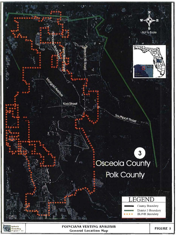
S-1