Attached files
| file | filename |
|---|---|
| 8-K - 8-K - Comstock Mining Inc. | v336228_8-k.htm |
| EX-99.1 - EXHIBIT 99.1 - Comstock Mining Inc. | v336228_ex99-1.htm |
Technical Report on the Comstock Mine Project, Virginia City, Nevada, USA
January 2013
1.0 SUMMARY
| 1.1 | PROPERTY POSITION AND OWNERSHIP |
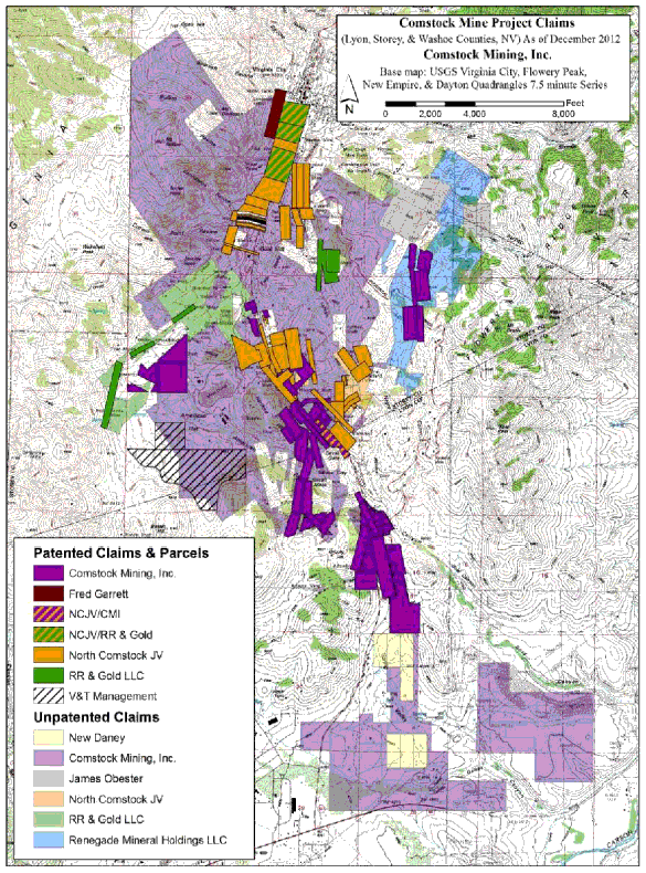
As of December 31, 2012, the Comstock Mine Project consists of approximately 5,900 acres of mining claims and parcels in the Comstock and Silver City Mining Districts. The acreage is comprised of approximately 1,350 acres of patented claims and surface parcels (private lands) and 4,550 acres of unpatented claims, administered by the United States Bureau of Land Management (BLM). A complete list of all the claims is stated in Appendix 1.0.
The Comstock Mine Project is 100% owned or controlled by Comstock Mining Inc. (CMI or "the Company") The property is located at approximately 119.66886° west longitude and 39.27389° north latitude in Storey and Lyon Counties, Nevada, adjacent to and extending south from Virginia City, Nevada, 30 miles southeast of Reno, Nevada.
The Lucerne resource area represents the largest classified gold and silver resource in the Comstock Mine Project and contains the previously mined Lucerne, Hartford, and Billie the Kid pits; the historic Justice, Keystone, and Woodville underground mines; and the recently discovered East Side and Chute zones. The Lucerne resource area is also host to CMI's Lucerne open pit mine, opened in 2012, with an associated heap leach and Merrill Crowe processing facility.
The Dayton resource area, approximately 1 mile south of the Lucerne resource area, along State Route 342, represents the Company's second largest classified gold and silver resource in the Comstock Mine Project and includes the historic Dayton, Alhambra, and Kossuth mines. The adjacent Spring Valley exploration target includes the site of the Company's 2009 discovery hole.
The Comstock Mine Project resource areas are located in portions of Sections 5, 6, and 8, Township 16 North, Range 21 East, Mount Diablo Baseline and Meridian (MDB&M), Storey County, Nevada and in portions of Sections 16 and 17 in Lyon County, Nevada. The Lucerne Mine site is adjacent to State Route 342 and south of the towns of Gold Hill, Nevada and Virginia City, Nevada. The Comstock Mine Project is located on both private lands and public lands administered by the BLM. The location of the Project is shown in Figure 1.1, and the entire CMI land position in the Comstock District is shown in Figure 1.2.
| Project 12-312 (NI 43-101) | 1 | BEHRE DOLBEAR |
Technical Report on the Comstock Mine Project, Virginia City, Nevada, USA
January 2013
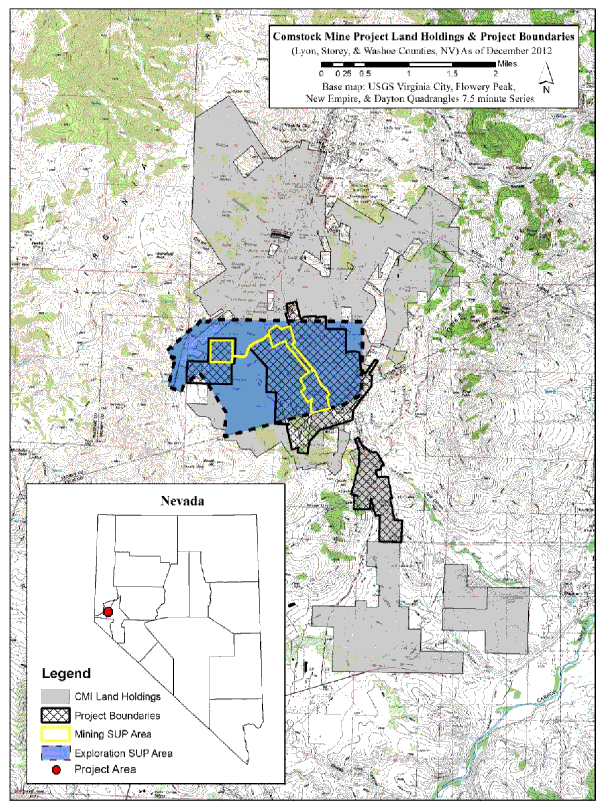
| Figure 1.1. | CMI Project location |
(Source: CMI, 2012)
| Project 12-312 (NI 43-101) | 2 | BEHRE DOLBEAR |
Technical Report on the Comstock Mine Project, Virginia City, Nevada, USA
January 2013
| Figure 1.2. | Comstock Mine Project land holding |
(Source: CMI, 2012)
| Project 12-312 (NI 43-101) | 3 | BEHRE DOLBEAR |
Technical Report on the Comstock Mine Project, Virginia City, Nevada, USA
January 2013
| 1.2 | OWNERSHIP CHANGES SINCE LAST NI 43-101 REPORT |
Since the last technical report, published in September 2011, CMI has further expanded and consolidated its land position in the Comstock District. The Company has opportunistically purchased mining patents and surface lots to further consolidate its controlled properties. CMI concluded specific transactions, which were:
| • | Exercised its option to acquire four mining patents and associated Silver City town lots from the Golden Goose Mine (October 17, 2011). This property makes up the core of the Dayton resource area, and was previously the subject of an Exploration License from Golden Goose. |
| • | Acquired the Diez Senores (Genessee) patent from Ms. Judith A Bryant. This 18-acre parcel is adjacent to and south of the Alhambra and Metropolitan patents in the Dayton resource area. |
| • | Acquired an option to purchase a 212-acre surface parcel in American Flat from V&T Management Company. |
| 1.3 | GEOLOGY |
The Comstock District is located within the western portion of the Basin and Range Province of Nevada, between Reno and Carson City. The majority of the epithermal ore bodies occur as veins, breccia zones, and stockwork veinlets, hosted in three major structural zones: the northeast striking, southeast dipping Comstock and Occidental fault zones, and the northwest striking, northeast dipping Silver City fault zone. The Comstock Mine Project deposits are all hosted by the Silver City fault zone and northeast striking faults that intersect it. Four sub-parallel, moderate- to low-angle brecciated fault zones, mapped from east to west as the Gold Canyon, Silver City, Billie the Kid, and Drysdale faults comprise the Silver City fault zone. Where the northeast striking faults intersect the Silver City fault zone, mineralization thickens and grade increases. The principal host rocks are Miocene-aged volcanic, volcanoclastic units, and various phases of quartz diorite/quartz porphyry to andesite porphyry as stocks, dikes, and plugs.
The Lucerne resource area includes the Lucerne, Billie the Kid, Hartford, Justice, Keystone, East Side, and Chute zones. Lucerne, Billie the Kid, and Justice are centrally located in the Lucerne resource area while the Hartford zone is up dip from the Lucerne pit and the East Side and Chute zones are down dip of the Lucerne pit. Most Lucerne resources are hosted in the Alta Formation, but much of the East Side and Chute zone is hosted in the Santiago Canyon Formation.
A significant discovery of higher-grade mineralization, termed by CMI geologists as the Chute zone, was discovered through the East Side drilling in 2012. Detailed mapping and further studies of the East Side drill holes revealed an intersection of the northwest striking and northeast dipping Silver City fault, a broad zone of N15°-25°E striking and southeast dipping mineralized fractures exposed in the Lucerne pit, and a N50°-60°E striking and southeast dipping zone of quartz veining and stockwork exposed on the surface. Projecting this complex series of structures onto level plans, the structures converged at the 4,600 and 4,500 foot elevations, defining a wedge shaped, N20°E trending, shallowly north plunging zone of enhanced mineralization confined between the hanging wall of the Silver City fault and the footwall of the N50°-60°E fault zone in the Santiago Canyon Formation tuff. This intersection zone hosts elevated grades of gold and silver that consistently average 0.095 ounces of gold per ton (3 g/t) over drill intercepts of 50 to 270 feet and has mapped dimensions of 100 to 150 feet by 100 feet by 450 feet.
| Project 12-312 (NI 43-101) | 4 | BEHRE DOLBEAR |
Technical Report on the Comstock Mine Project, Virginia City, Nevada, USA
January 2013
The Dayton resource area includes the historic Dayton, Alhambra, and Kossuth mines, along the southern strike extension of the Silver City fault zone. Dayton mineralization is hosted in the Santiago Canyon Formation. Drilling at Dayton is still widely-spaced but sufficient to prove continuity of geology and mineralization. In 2012, there were no additional drill holes at Dayton as the exploration effort focused on the Lucerne resource area, and thus there are no changes from the 2011 resource estimation (Behre Dolbear, 2011).
| 1.4 | MINERALIZATION |
The Lucerne resource has a strike length from the Billie the Kid to the Justice area of about 4,300 feet and when extended northward to the Keystone area, it is about 5,400 feet long. Substantial resources have been identified to the south at the Dayton property and encouraging exploration results have been received at Spring Valley, immediately to the south of the Dayton resource.
Mineralization within the project is gold enriched, with silver to gold ratios of approximately 10:1. This compares to ratios of silver to gold of 100:1, recorded for the historic Comstock bonanza ore bodies. Geologic studies have shown that the northeast striking, southeast dipping structures host a fairly unique, for the district, silver to gold ratio of approximately 1:1. This is particularly important since mineralization blossoms at the intersections of N50°E and N70°E striking, southeast dipping veins and the major, northwest striking Silver City fault zone.
Gold and silver mineralization in the project area typically occurs within late-stage manganiferous calcite-quartz and drusy quartz filling faults, fractures, breccia zones, and stockwork veinlets. Base metals have been identified at depth associated with quartz veining and near proximity to a quartz monzonite intrusive body. The base metal sulfides identified to date are molybdenite, sphalerite, galena, pyrite, chalcopyrite, and kermesite.
An unexpected attribute of the mineralization was identified by two independent studies. One study, prompted by Gene McClelland of McClelland Metallurgical Laboratories and conducted by Dr. Tommy Thompson, was completed in January 2011. Another study prompted by CMI, after identifying visible gold particles under 10x magnification, was conducted by American Assay Laboratories utilizing their inhouse electron microscope. Each study identified gold and silver mineralization on micron levels as the following: native gold particles approximately 20 to 50 microns by 5 microns thick, often associated with goethite; native silver wires approximately 5 microns in diameter by up to 100 microns long; ruby silver minerals, for example proustite and pyrargyrite; and electrum (gold and silver) particles greater than 300 microns. Further electron microscope analysis of the metallic particles greater than 300 microns identified that they were a combined cluster of individual 20 to 50 micron particles with open pore space between the particles.
It is visually obvious from a study of satellite photos and demonstrated by detailed mapping and drill hole logging that there is a direct genetic and spatial relationship between interpreted arcuate, circular, and linear features, and district-wide mineralization, quartz porphyry dikes, rhyolite domes, and deeper-seated molybdenum-bearing monzonite domes.
| 1.5 | DRILLING, SAMPLING, AND ASSAYING |
During 2012, reverse circulation (RC) drilling focused upon the in-fill, condemnation, and production requirements in the Lucerne, Hartford, Billie the Kid, Justice, Keystone, and St. Louis areas. Additionally,
| Project 12-312 (NI 43-101) | 5 | BEHRE DOLBEAR |
Technical Report on the Comstock Mine Project, Virginia City, Nevada, USA
January 2013
limited step-out and in-fill drilling on the East Side led to the discovery of the Chute zone. Core drilling focused on geotechnical holes for pit slope design and large diameter holes for metallurgical data.
During 2012, 364 RC holes totaling 138,521 feet and 27 diamond drill holes totaling 7,754 feet were drilled by CMI. A total of 1,877 RC holes totaling 540,051 feet and 127 core holes totaling 33,226 feet have been drilled by CMI and their predecessors and have defined resources in the Comstock Mine Project. In-fill drilling at the Lucerne deposit is approximately on a 50-foot by 50-foot grid to confirm mineral continuity and to improve the resource status.
Drilling is by RC and diamond coring methods. RC sampling is undertaken using a wet rotary splitter. Representative 5-foot splits plus duplicates on 100-foot intervals are collected, with the samples being secured with good chain of custody from the drill site to the primary assay laboratory. Diamond drill core is sawn in half for sampling.
All RC and core drilling and sampling procedures meet or exceed industry-standards. The author opines that the RC samples are representative of the material drilled. The security measures taken ensure the validity and integrity of samples collected until the assay laboratory takes possession. The author's opinion is that sample preparation, security, analytical procedures, and subsequent assay results from certified laboratories are compliant with NI 43-101 guidelines and meet all industry standards.
| 1.6 | RESOURCES AND RESERVES |
| 1.6.1 | Resources |
Based on a gold cutoff of 0.007 ounce per ton, the estimated Measured and Indicated Resources for the Lucerne resource area are approximately 53,550,000 tons, with an average gold grade of 0.030 ounce per ton and an average silver grade of 0.286 ounce per ton. The estimated Measured and Indicated Resources for the Dayton resource area are approximately 8,330,000 tons, with an average gold grade of 0.029 ounce per ton and an average silver grade of 0.213 ounce per ton. The total Measured and Indicated Resources at the Comstock Mine Project are approximately 61,880,000 tons, with an average gold grade of 0.029 ounce per ton and an average silver grade of 0.276 ounce per ton.
There is an additional Inferred Resource of 26,300,000 tons in the Lucerne Model with an average gold grade of 0.021 ounce per ton and an average silver grade of 0.177 ounce per ton, and 8,590,000 tons in the Dayton Model with an average gold grade of 0.024 ounce per ton and an average silver grade of 0.131 ounce per ton. The total Inferred Resources at the Comstock Mine Project are approximately 34,890,000 tons, with an average gold grade of 0.022 ounce per ton and an average silver grade of 0.166 ounce per ton. The estimated in-situ resources for the Comstock Mine Project are shown in Table 1.1.
| Project 12-312 (NI 43-101) | 6 | BEHRE DOLBEAR |
Technical Report on the Comstock Mine Project, Virginia City, Nevada, USA
January 2013
| TABLE 1.1 | |||||
| COMSTOCK MINE PROJECT RESOURCE SUMMARY | |||||
| Tons1 |
Au (opt) |
Ag (opt) |
Total Au (ounces) |
Total Ag (ounces) | |
| Measured Resource | 35,230,000 | 0.030 | 0.307 | 1,057,000 | 10,820,000 |
| Indicated Resource | 26,650,000 | 0.029 | 0.236 | 767,000 | 6,280,000 |
| Total Measured and Indicated2 | 61,880,000 | 0.029 | 0.276 | 1,824,000 | 17,100,000 |
| Inferred Resource | 34,890,000 | 0.022 | 0.166 | 758,000 | 5,790,000 |
|
1Resource total based on a gold cutoff of 0.007 ounce per ton 2Rounding differences may occur | |||||
The author believes that the resource model estimates and classifications are appropriate and conform to NI 43-101 Technical Report guidelines.
| 1.6.2 | Reserves |
Proven or Probable Reserves cannot be stated under NI 43-101 Technical Report requirements at this time. CMI is currently pre-planning the additional drilling, metallurgical testing, and geotechnical testing followed by mine planning and economic analysis that are the required elements of a pre-feasibility study for an Expanded Lucerne Mine. This necessary mine design work, metallurgical testing, operating cost and capital cost estimation, and permitting will be required to create a Mineral reserve.
| 1.7 | MINING METHODS |
The Comstock Mine Project is a hard rock operation, currently targeted for mining by one or more open pits that encompass several of the previously mined smaller pits and some of the old underground workings. Underground mining will be considered, when the economics are favorable, for deeper mineralized bodies.
Mining in the Lucerne resource area will proceed in multiple phases. The first phase, called the Lucerne Mine, began mine construction activities in May 2012 and is located entirely on patented (private) land controlled by CMI. This allows for accelerated mining and heap leaching within current permitted boundaries. CMI has installed crushing facilities, a redesigned and expanded Merrill Crowe processing facility, and has purchased a mining equipment fleet, which has been at work since mid-2012. The first gold pour occurred in late September 2012.
Concurrent with the operation of the Lucerne Mine, CMI is currently pre-planning for incremental expansion. The Company intends to complete East Side development drilling, metallurgical testing, and geotechnical testing, followed by mine planning and economic analysis. There are a number of expansion scenarios for the Lucerne Mine, many of which include public lands administered by the BLM, and some which require the eventual realignment of State Route 342. Assuming an expansion involving public lands is found to be feasible, a Plan of Operations would be prepared and filed with the BLM to initiate federal permitting.
| Project 12-312 (NI 43-101) | 7 | BEHRE DOLBEAR |
Technical Report on the Comstock Mine Project, Virginia City, Nevada, USA
January 2013
| 1.8 | PROCESSING |
Heap leach processing was initiated in 2012 with 294,093 tons of mineralized material placed on the heap for leaching by year-end 2012. The average grade of the placed material was 0.028 ounces of gold and 0.350 ounces of silver per ton. During the year, approximately 8,230 contained ounces of gold and 103,000 contained ounces of silver were placed on the heap. The metal production through the end of 2012 was 2,605.3 ounces of gold and 28,612 ounces of silver.
The current, calculated metallurgical recoveries are approaching the predicted gold recovery and have exceeded the predicted silver recovery. The portion of the heap under leach the longest, 80 days, has recovery of gold estimated at 67% and the recovery of silver estimated at 51%. Preliminary laboratory metallurgical test results provide CMI confidence that ultimate heap leach recoveries will meet or exceed the expected 70% for gold and 45% for silver.
| 1.9 | ENVIRONMENTAL AND PERMITTING |
CMI is fully permitted and resumed operations during the second half of 2012 with mining and processing activities on private lands and patented mineral claims. The current Lucerne Mine operation uses street-legal trucks on State Route 342 and a temporary right-of-way on an existing dirt road crossing BLM administered lands.
CMI has filed a Plan of Development (POD) with the BLM for a permanent Lucerne right-of-way (ROW) between the Lucerne Mine and the American Flat processing facility, and began the Environmental Assessment (EA) process under NEPA. Late in the fourth quarter of 2012, CMI and the BLM entered into a Memorandum of Understanding (MOU) to expedite the remainder of the permitting process for the Lucerne ROW. In January, the BLM launched the public scoping for comments associated with the permit application. The relevant public meetings have been completed, with strong public support. CMI expects this matter to reach a favorable conclusion during the next 6 to 12 months. The author agrees that this is a reasonable expectation.
In addition, the BLM is also processing a Color of Title application to resolve and recover the use of Lot 51, one of the factors that blocked access to the previously-used haul road. Either the granting of the Lucerne ROW or acceptance of the Color of Title would allow more expedient haulage and improve hauling efficiency and increase profitability while reducing impact on the public.
| 1.10 | PROJECT ECONOMICS |
The author verified that the cutoff grade selected for the Lucerne and Dayton resources (0.007 ounces of gold per ton) is close to the forecast break-even internal cutoff grade derived from the expected processing and general and administrative (G&A) operating costs.
The author further verified that the average gold and silver grades summarized for the Lucerne resource table (0.030 ounce per ton and 0.286 ounce per ton, respectively) and CMI's forecasts of future operating costs should result in a strong profit margin for the Lucerne Mine operations at current metal prices.
Forecast operating costs were also compared with the very preliminary results from the first three months of actual operations, and are considered by the author to be in reasonable agreement.
| Project 12-312 (NI 43-101) | 8 | BEHRE DOLBEAR |
Technical Report on the Comstock Mine Project, Virginia City, Nevada, USA
January 2013
| 1.11 | CONCLUSIONS |
| 1.11.1 | Geology and Exploration |
The author believes the Comstock Mine Project represents a well-explored, epithermal, precious metal deposit within a world-class mining district. The deposit is hosted in structurally prepared rocks within the northwest striking, northeast dipping Silver City fault zone. Grades and extent of mineralization are enhanced where this fault zone is intersected by east-west and north-east striking faults. The geology of the project area is well described and understood through vigorous surface mapping and drill hole logging. The density of geologic data is high, and the reliability is excellent, particularly in the various Lucerne Mine areas. Additional drilling is required down dip especially in the East Side zone and the newly discovered Chute zone.
Drilling and assaying followed accepted industry-standard methods, and the evaluation of Quality Assurance/Quality Control (QA/QC) results is very good. Exploration opportunities to expand the known mineralization down-dip and along strike to the north, south, and east are still good, excellent in the East Side and Chute zones, and have the potential of adding considerably to the estimated Measured and Indicated Resource.
| 1.11.2 | Mining |
CMI has followed through on recommendations made by the author in the September 2011 NI 43-101 report and has done considerable additional work on slope stability and final pit slopes in the Lucerne Mine area. A second consultant, Geocon Consultants, Inc. (Geocon), was engaged, additional core oriented holes were drilled, and additional surface observations and mapping were carried out. Building on the first consultant's June 2011 report, Geocon made slope angle recommendations that CMI has used in current and future pit designs for the Lucerne Mine.
| 1.12 | RECOMMENDATIONS |
| 1.12.1 | Geology and Mineral Resources |
| • | In the Lucerne Mine area, development drilling should be continued where necessary to assure continuity of the present mine plan. Similarly, in-fill drilling between the Billie the Kid highwall and the St. Louis ramp is recommended. Also, in-fill drilling between the Hartford and Lucerne pits is recommended as soon as BLM access is available. |
| • | RC drilling in the East Side and Chute zones should continue initially as step-out holes followed by in-fill drilling to fully evaluate the options for expanding the Lucerne Mine. |
| • | Additional drilling is recommended at the Dayton resource area and the Spring Valley exploration area. Shallow trenching continues to be recommended in the Spring Valley area so that a better understanding of the geology is gained. |
| • | Preliminary field investigations should be initiated on peripheral CMI lands where domal, arcuate, and linear features intersect. Some initial drilling is recommended, if field investigation results warrant. |
| Project 12-312 (NI 43-101) | 9 | BEHRE DOLBEAR |
Technical Report on the Comstock Mine Project, Virginia City, Nevada, USA
January 2013
| • | The author recommends that additional QA/QC standards that fall between 0.007 ounces of gold per ton (the resource cutoff grade) and 0.023 ounces of gold per ton (OxF100, the present lowest-grade certified standard) be added to the group of standards used at the project. |
| 1.12.2 | Mining |
| • | CMI should evaluate whether additional geotechnical core holes may be necessary, if and when mining moves beyond the limits of the current Lucerne Mine. |
| 1.12.3 | Processing |
| • | It is suggested that a record of the tonnages of the rock placed on the heap include an indication of the rock types and also to allow some extrapolation from the metallurgical test work predictions to the actual heap leach recoveries. This may allow some additional predictability of expected recoveries and the time required for ongoing operations. |
| 1.12.4 | Permitting |
| • | CMI should complete the East Side drilling, metallurgical and geotechnical testing, and economic analysis required for an Expanded Mine in the Lucerne resource area, including establishing alternatives for realigning State Route 342, and designing a new or expanded processing facility. |
| • | Once a feasible plan is finalized, CMI should move expeditiously toward preparing and submitting a Plan of Operations to the BLM to initiate permitting for the expansion. |
| Project 12-312 (NI 43-101) | 10 | BEHRE DOLBEAR |