Attached files
| file | filename |
|---|---|
| 8-K - FORM 8-K - Trilogy Metals Inc. | form8k.htm |
| NOVACOPPER INC. |
| Technical Report for the |
| Bornite Deposit |
South Reef and Ruby Creek Zones,
Northwest Alaska,
USA
| Report Prepared for |
| NovaCopper Inc. |
| 2300-200 Granville Street |
| Vancouver, British Columbia |
| V6C 1S4 Canada |
| Report Prepared by |
| BD Resource Consulting, Inc. |
| 4235 Cheyenne Drive |
| Larkspur, CO 80118 |
| Signed by QP: |
| Bruce Davis, FAusIMM |
| Robert Sim P.Geo. |
| Effective Date: January 31, 2013 |
| Release Date: February 8, 2013 |
 |
UPPER KOBUK MINERAL PROJECTS |
| BORNITE DEPOSIT – SOUTH REEF AND RUBY CREEK ZONES | |
| ALASKA, USA | |
| NI 43-101 TECHNICAL REPORT | |
Table of Contents
| TOC i |
| January 31, 2013 |
|
UPPER KOBUK MINERAL PROJECTS |
| BORNITE DEPOSIT – SOUTH REEF AND RUBY CREEK ZONES | |
| ALASKA, USA | |
| NI 43-101 TECHNICAL REPORT | |
| TOC ii |
| January 31, 2013 |
|
UPPER KOBUK MINERAL PROJECTS |
| BORNITE DEPOSIT – SOUTH REEF AND RUBY CREEK ZONES | |
| ALASKA, USA | |
| NI 43-101 TECHNICAL REPORT | |
| TOC iii |
| January 31, 2013 |
|
UPPER KOBUK MINERAL PROJECTS |
| BORNITE DEPOSIT – SOUTH REEF AND RUBY CREEK ZONES | |
| ALASKA, USA | |
| NI 43-101 TECHNICAL REPORT | |
| TOC iv |
| January 31, 2013 |
|
UPPER KOBUK MINERAL PROJECTS |
| BORNITE DEPOSIT – SOUTH REEF AND RUBY CREEK ZONES | |
| ALASKA, USA | |
| NI 43-101 TECHNICAL REPORT | |
| TOC v |
| January 31, 2013 |
|
UPPER KOBUK MINERAL PROJECTS |
| BORNITE DEPOSIT – SOUTH REEF AND RUBY CREEK ZONES | |
| ALASKA, USA | |
| NI 43-101 TECHNICAL REPORT | |
| TOC vi |
| January 31, 2013 |
|
UPPER KOBUK MINERAL PROJECTS |
| BORNITE DEPOSIT – SOUTH REEF AND RUBY CREEK ZONES | |
| ALASKA, USA | |
| NI 43-101 TECHNICAL REPORT | |
| TOC vii |
| January 31, 2013 |
|
UPPER KOBUK MINERAL PROJECTS |
| BORNITE DEPOSIT – SOUTH REEF AND RUBY CREEK ZONES | |
| ALASKA, USA | |
| NI 43-101 TECHNICAL REPORT | |
| 1 |
SUMMARY |
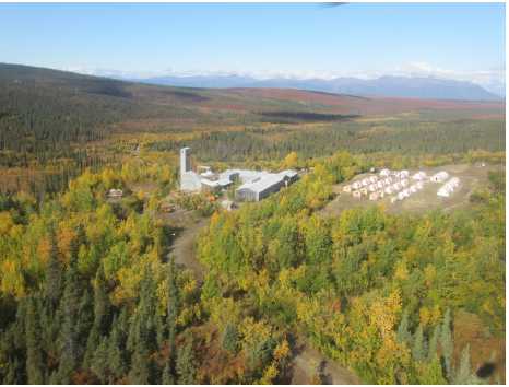
BD Resource Consulting Inc. (BDRC) was commissioned by NovaCopper Inc. (NovaCopper) and NovaCopper US Inc. (NovaCopper US), a wholly-owned subsidiary of NovaCopper, to prepare an updated 43-101 Technical Report on the Bornite deposit. The Bornite deposit is one of several mineralized occurrences at the Upper Kobuk Mineral Projects encompassing a portion of the Ambler mining district of northwestern Alaska. BDRC has previously reported on the Ruby Creek zone of the Bornite deposit. This updated NI 43-101 Technical Report includes the newly discovered South Reef zone and presents comprehensive results for the Bornite deposit. Figure 1-1 shows an aerial view of the Bornite exploration shaft and the NovaCopper exploration camp.
FIGURE 1-1: EXPLORATION SHAFT AND CAMP
On October 19, 2011, NovaCopper US entered into an Exploration Agreement and Option to Lease (the NANA Agreement) with the NANA Regional Corporation, Inc. (NANA) for the cooperative development of their respective resource interests in the Ambler mining district. The NANA Agreement consolidates NovaCopper’s Ambler Project land holdings, NANA’s Bornite land holdings, and certain (Alaska Native Claims Settlement Act (ANSCA) Lands (each as defined in the NANA Agreement) into a land package of approximately 143,191 ha; these lands are collectively referred to as the Upper Kobuk Mineral Projects (UKMP), hosting the Arctic deposit resources and the Bornite deposit resources. The deposits are independent of one another due to their distance and differing ore deposit types. The NANA Agreement provides a framework for the exploration and any future development of the UKMP lands. On April 30, 2012, NovaGold Resources Inc. (NovaGold) completed a corporate reorganization in which NovaCopper and its Upper Kobuk Mineral Projects were successfully spun out as a new independent, public company trading on the NYSE-MKT and TSX exchanges.
| Page 1-1 |
| January 31, 2013 |
|
UPPER KOBUK MINERAL PROJECTS |
| BORNITE DEPOSIT – SOUTH REEF AND RUBY CREEK ZONES | |
| ALASKA, USA | |
| NI 43-101 TECHNICAL REPORT | |
| 1.1 |
Location |
The UKMP which encompasses the Bornite deposit and the previously reported Arctic deposit are located approximately 160 miles (260 km) east of Kotzebue, Alaska and 285 miles (460 km) northwest of Fairbanks, Alaska. The closest village is the community of Kobuk, approximately 10.5 miles (17 km) to the south situated along the banks of the Kobuk River.
| 1.2 |
Land Status |
The UKMP constitute a land package of approximately 143,191 ha and is governed by the NANA Agreement which provides a framework for exploration and resource development of the UKMP lands.
The UKMP are an amalgamation of: NovaCopper’s Ambler lands comprising 112,058 acres (45,348 ha) of the State of Alaska's mining claims and Federally-patented mining claims located in the Ambler mining district of the southern Brooks Range of northwestern Alaska, and NANA’s Bornite and ANCSA Lands as outlined in the NANA Agreement. The Bornite deposit which is the basis for this National Instrument 43-101 Technical Report is located on NANA lands.
| 1.3 |
History |
Regional exploration began in the early 1900s when gold prospectors noted copper occurrences in the hills north of Kobuk, Alaska. In 1947, local prospector Rhinehart “Rhiny” Berg, along with various partners traversing in the area, located outcropping mineralization along Ruby Creek (Bornite) on the north side of the Cosmos Hills. Bear Creek Mining Company, Kennecott's exploration subsidiary, optioned the property from Berg in 1957. In 1961, drilling culminated in the discovery of the No.1 Ore Body when drill hole DDH-RC-34 cut 65.6 ft (20 m) of 24% Cu (copper).
The discovery of the No.1 Ore Body led to the development of a 1,075 ft (328 m) exploration shaft in 1966 which provided access for sampling, mapping, and underground drilling to further delineate the No. 1 Ore Body.
| Page 1-2 |
| January 31, 2013 |
|
UPPER KOBUK MINERAL PROJECTS |
| BORNITE DEPOSIT – SOUTH REEF AND RUBY CREEK ZONES | |
| ALASKA, USA | |
| NI 43-101 TECHNICAL REPORT | |
In 1965, the discovery of the Arctic deposit, 11 miles (17 km) to the northeast, focused Kennecott's exploration efforts elsewhere in the district resulting in an exploration hiatus at Bornite. In 1989, Kennecott sold its interest in Bornite to NANA, but re-acquired the property from NANA in 1997 for a short period to complete minor, additional drilling.
In 2004, NovaGold began discussions with NANA concerning an acquisition that eventually resulted in the NANA Agreement in October 2011. The agreement allowed the consolidation, exploration, and development of the UKMP. In 2011, exploration drilling by NovaGold identified the South Reef area as a potential new resource which was then extensively drilled by NovaCopper in 2012. The results of that drilling are incorporated in this report.
| 1.4 |
Geological Setting |
Mineralization in the UKMP area is characterized by two discrete mineralized belts: the Devonian Ambler Schist Belt and the Devonian Bornite carbonate sequence. The Ambler Schist Belt is host to a series of VMS (volcanogenic massive sulphide) deposits related to metamorphosed and strongly deformed bimodal Devonian volcanic and sedimentary rocks. A series of notable VMS deposits, including the Arctic, Dead Creek (Shungnak), Sunshine, Horse Creek, Sun, and Smucker deposits, occur in this belt.
At Bornite, the focus of this NI 43-101 technical report, mineralization is hosted in less-strongly deformed Devonian clastic and carbonate sedimentary rocks lying immediately south of the Schist Belt rocks across the Ambler lowlands. Widespread hydrothermal dolomitization is characteristic of the belt and hosts the associated copper mineralization.
| 1.5 |
Deposit Type |
Bornite has characteristics similar to a series of districts and deposits including the Mt Isa district in Australia, the Tynagh deposit in Ireland, the Kipushi deposit in the Congo, and the Tsumeb deposit in Namibia. All of these deposits show: syngenetic to early epigenetic characteristics; emplacement in carbonate stratigraphy; and, early pyrite-dolomite alteration followed by sulphide mineralization. All occur in intra-continental to continental margin settings undergoing extensional tectonics and bimodal volcanism. Basin-margin faults seem to play an important role in localizing mineralization.
| 1.6 |
Mineralization |
Copper mineralization at Bornite is comprised of chalcopyrite, bornite, and chalcocite as stringers, veinlets, and breccia fillings distributed in stacked, roughly stratiform zones exploiting favourable stratigraphy. Stringer pyrite and locally significant sphalerite occur above and around the copper zones, while locally massive pyrite and sparse pyrrhotite occur in association with siderite alteration below copper mineralization in the Lower Reef.
| Page 1-3 |
| January 31, 2013 |
|
UPPER KOBUK MINERAL PROJECTS |
| BORNITE DEPOSIT – SOUTH REEF AND RUBY CREEK ZONES | |
| ALASKA, USA | |
| NI 43-101 TECHNICAL REPORT | |
| 1.7 |
Bornite Mineral Resources – South Reef and Ruby Creek Zones |
In 2012, NovaCopper drilled 21 holes targeting the newly discovered South Reef zone paralleling and lying approximately 600 m southeast of the Ruby Creek zone. In 2012, drilling defined an approximately 250 m wide by 700 m long zone of mineralization at South Reef, the estimation results are shown in Table 1.1.
TABLE 1.1: RESULTS FROM SOUTH REEF ZONE RESOURCE ESTIMATION AT BORNITE
| Inferred | |||
| Cut-off % Cu |
Tonnes (millions) |
Grade % Cu |
Pounds (millions) |
| 0.5 | 104.3 | 1.46 | 3,344 |
| 1.0 | 43.1 | 2.54 | 2,409 |
| 1.5 | 28.8 | 3.21 | 2,037 |
| 2.0 | 25 | 3.44 | 1,896 |
| 2.5 | 21.7 | 3.61 | 1,730 |
| 3.0 | 16 | 3.92 | 1,382 |
| 3.5 | 9.5 | 4.38 | 916 |
| 4.0 | 4.9 | 4.99 | 543 |
|
1. |
Base Case is a 1.0% Cu cut-off grade. |
|
2. |
Mineral Resources are not Mineral Reserves and do not have demonstrated economic viability. There is no certainty that all or any part of the Mineral Resources will be converted into Mineral Reserves. |
|
3. |
Mineral Resources at a 1% cut-off are considered as potentially economically viable in an underground mining scenario based on an assumed projected copper price of US$2.75/lb and total site operating costs of US$60.00/tonne. |
|
4. |
Mineral resource tonnage and contained metal have been rounded to reflect the accuracy of the estimate, and numbers may not add due to rounding. |
| Page 1-4 |
| January 31, 2013 |
|
UPPER KOBUK MINERAL PROJECTS |
| BORNITE DEPOSIT – SOUTH REEF AND RUBY CREEK ZONES | |
| ALASKA, USA | |
| NI 43-101 TECHNICAL REPORT | |
In 2011, NovaGold drilled a series of holes to verify the historical Kennecott drilling in the Ruby Creek zone and to begin exploration in and around the deposit. Results from the Ruby Creek zone which contain two discrete mineralized lenses, the Upper and Lower Reef, are shown in Table 1.2. The Upper Reef is located approximately 300 m north of the outcropping Lower Reef and includes a small, but very high-grade, area dubbed the "No.1 Orebody" by Kennecott.
The Kennecott drilling was conducted using imperial measurement units. Imperial units have been converted to metric equivalents in the NovaCopper database. NovaCopper worked exclusively in metric units.
TABLE 1.2: RESULTS FROM 2012 RUBY CREEK ZONE RESOURCE ESTIMATION AT BORNITE
| Indicated | Inferred | |||||
| Cut-off % Cu |
Tonnes
(millions) |
Grade % Cu |
Pounds
(millions) |
Tonnes
(millions) |
Grade % Cu |
Pounds
(millions) |
| 0.3 | 9.0 | 1.00 | 198.6 | 74.3 | 0.68 | 1113.3 |
| 0.5 | 6.8 | 1.19 | 178.7 | 47.7 | 0.84 | 883.2 |
| 1.0 | 2.4 | 2.03 | 109.3 | 11.4 | 1.31 | 329.8 |
| 1.5 | 1.0 | 3.26 | 71.6 | 1.9 | 1.94 | 82.8 |
| 2.0 | 0.6 | 4.49 | 55.0 | 0.5 | 2.65 | 30.3 |
| 1. |
Base Case is 0.5% Cu cut-off grade. |
| 2. |
Mineral Resources are not Mineral Reserves and do not have demonstrated economic viability. There is no certainty that all or any part of the Mineral Resources will be converted into Mineral Reserves. |
| 3. |
Resources stated as contained within a manually constructed potentially economic resource limiting pit shell using metal price of US$3.00/lb Cu, mining costs of US$1.50/tonne, processing costs of US$10.00/tonne, 100% recoveries and an average pit slope of 45 degrees. |
| 4. |
Mineral resource tonnage and contained metal have been rounded to reflect the accuracy of the estimate, and numbers may not add due to rounding. |
| 1.8 |
Project Status |
In 2013, NovaCopper expects to continue expansion of the Bornite deposit. The 2013 program may include three drill rigs and approximately 29,500 ft (9,000 m) of drilling targeted at expanding the South Reef resource.
| Page 1-5 |
| January 31, 2013 |
|
UPPER KOBUK MINERAL PROJECTS |
| BORNITE DEPOSIT – SOUTH REEF AND RUBY CREEK ZONES | |
| ALASKA, USA | |
| NI 43-101 TECHNICAL REPORT | |
| 1.9 |
Conclusions and Recommendations |
Based on the recent assembly and verification of historic data, and drilling by NovaCopper on the Bornite deposit, the following conclusions can be made:
-
The level of understanding of the Bornite deposit geology is relatively good. The practices used during the various drilling campaigns were conducted in a professional manner and adhered to accepted industry standards. There are no evident factors that would lead one to question the integrity of the database.
-
A significant copper deposit comprised of several discrete zones of mineralization (South Reef and Ruby Creek zones) continues to be outlined. Mineralization is hosted in stratiform zones occurring in favourable carbonate stratigraphy. There is significant potential to continue to expand the deposit.
-
Drilling to date in the South Reef zone has produced an estimated Inferred resource (at a 1.0% Cu cut-off) of 43.1 Mtonnes of 2.54% Cu.
-
Drilling to date in the Ruby Creek zone has produced an estimated Indicated resource (at a 0.5% Cu cut-off) of 6.8 Mtonnes at 1.19% Cu and an Inferred resource (at a 0.5% Cu cut-off) of 47.7 Mtonnes at 0.84% Cu.
The following actions are recommended for the Bornite deposit:
-
Additional drilling to determine the extent of the mineralization in the South Reef zone, especially down dip of the current mineralization. A budget of US$2.0 million is proposed to complete this work.
-
Additional drilling to further define the higher-grade zones in both the Upper and Lower Reefs of the Ruby Creek and South Reef zones. A budget of US$2.0 million is proposed to complete this work.
-
Consolidated exploration program testing for satellite deposits that includes: geophysics, geochemistry, geologic mapping, and drilling. A budget of US$1.5 million is proposed to complete this work.
-
Following next phase of drilling, a preliminary economic assessment that includes: geotechnical work, metallurgical studies, hydrological studies, resource estimation (including further collection and analysis of specific gravity data and further verification and analysis of the historical drilling data), mine planning, and an economic analysis of the Project. A budget of US$1.5 million is proposed to complete this work.
| Page 1-6 |
| January 31, 2013 |
|
UPPER KOBUK MINERAL PROJECTS |
| BORNITE DEPOSIT – SOUTH REEF AND RUBY CREEK ZONES | |
| ALASKA, USA | |
| NI 43-101 TECHNICAL REPORT | |
| 2 |
INTRODUCTION |
This Technical Report has been prepared for NovaCopper U.S. Inc. (NovaCopper US), a wholly-owned subsidiary of NovaCopper Inc. (NovaCopper), by Bruce Davis of BD Resource Consulting, Inc. (BDRC).
| 2.1 |
Terms of Reference |
This report documents the recent mineral resource estimate for the Bornite deposit which is part of NovaCopper's Upper Kobuk Mineral Projects (UKMP). The UKMP consolidates NovaCopper’s Ambler land holdings, NANA’s Bornite land holdings, and certain Alaska Native Claims Settlement Act (ANCSA) Lands, and provides a framework for the exploration and development of these lands through an Exploration Agreement and Option to Lease (the NANA Agreement) with NANA Regional Corporation, Inc. (NANA).
This report also discusses historic and current exploration results and outlines work carried out by BDRC to generate a mineral resource estimate for the South Reef and Ruby Creek mineralized zones at Bornite.
This report does not include the Arctic deposit discussed in Section 2.6 due to the physical separation of the Bornite and Arctic deposits and their differences in the type and style of the deposits. At this early stage, it is unclear whether future engineering studies will identify a synergy between the Bornite and Arctic deposits.
This report complies with the reporting and disclosure requirements outlined in the TSX Exchange (TSX) Company Manual and the Canadian Securities Administrators National Instrument 43-101 Standards of Disclosure for Mineral Projects (NI 43-101).
| 2.2 |
Qualified Persons |
Bruce Davis, FAusIMM, is the president of BDRC and the author of this Technical Report. Bruce Davis is an independent “qualified person”, within the meaning of NI 43-101. He is responsible for the preparation of this Technical Report on the Bornite deposit (Technical Report) which has been prepared in accordance with NI 43-101 and Form 43-101F1.
Robert Sim, PGeo, is the president of SIM Geological Inc. (SGI) and the co-author of Section 14 of this Technical Report. Robert Sim is an independent “qualified person”, within the meaning of NI 43-101. He contributed to the resource estimation of the South Reef zone on the Bornite property (Technical Report) which has been prepared in accordance with NI 43-101 and Form 43-101F1.
| Page 2-1 |
| January 31, 2013 |
|
UPPER KOBUK MINERAL PROJECTS |
| BORNITE DEPOSIT – SOUTH REEF AND RUBY CREEK ZONES | |
| ALASKA, USA | |
| NI 43-101 TECHNICAL REPORT | |
Neither Bruce Davis or Robert Sim, or any associates employed in the preparation of this report (Consultants), have any beneficial interest in NovaCopper. These Consultants are not insiders, associates, or affiliates of NovaCopper. The results of this Technical Report are not dependent on any prior agreements concerning the conclusions of this report, and there are no undisclosed understandings concerning future business dealings between NovaCopper and the Consultants. The Consultants are paid a fee for their work in accordance with normal professional consulting practices.
| 2.3 |
Site Visit |
Bruce Davis conducted a site visit to the UKMP on July 26-27, 2011, and again on September 25, 2012. Davis arrived via charter aircraft and was driven to the Bornite exploration camp and logging facility. Figure 2-1 shows the Bornite exploration shaft and the NovaCopper exploration camp. The site visits included a review of: drilling procedures, site facilities, historic and recent drill core, logging procedures, data capture, and sample handling. During the 2012 Bornite site visit, Davis also visited the Arctic deposit via helicopter.
Figure 2-1: Bornite Exploration Shaft and the NovaCopper Exploration Camp
![]()
| 2.4 |
Effective Date |
The effective date of this report is January 31, 2013.
| Page 2-2 |
| January 31, 2013 |
|
UPPER KOBUK MINERAL PROJECTS |
| BORNITE DEPOSIT – SOUTH REEF AND RUBY CREEK ZONES | |
| ALASKA, USA | |
| NI 43-101 TECHNICAL REPORT | |
| 2.5 |
Information Sources and References |
NovaCopper provided electronic copies of drill hole data and various geologic reports, maps, cross sections, and miscellaneous data to BDRC. NovaCopper US obtained the data as a part of the acquisition of the Ambler lands from Alaska Gold Company, LLC, a wholly-owned subsidiary of NovaGold Resources Inc. (collectively NovaGold), on October 17, 2011. NovaGold had originally obtained project data from both NANA Regional Corporation Inc. and Kennecott Arctic Company (Kennecott) who had discovered and explored the Bornite deposit from 1957-1998.
All of the drill data collected during the Kennecott drilling programs (1958-1997) was logged on paper drill logs, copies are now stored in Kennecott's exploration office in Salt Lake City, Utah. In 1995, Kennecott scanned and converted the drilling assay data, geologic core logs, and the down-hole and collar survey information into an electronic format. In 2009, NovaGold geologists verified the geologic data comparing the original paper logs against the Kennecott database, and merged all the data into a Microsoft™ SQL database for the deposit.
The 2011 and 2012 NovaGold/NovaCopper diamond drilling programs used a commercial, computer-based core logging system for data capture: GeoSpark Logger© (data logger) developed by GeoSpark Consultants Inc. GeoSpark Logger© stores and validates the information logged in a Microsoft™ SQL database and merges it into the main SQL database for the project. Hardcopies of the 2011 and 2012 drill core logs are stored in the Fairbanks office. Scanned copies of the Kennecott-era drill logs are also stored in the Fairbanks field office.
| 2.6 |
Previous Technical Reports |
On July 18, 2012, NovaCopper filed a NI 43-101 Technical Report on the Ruby Creek zone of the Bornite mineral deposit based on NovaGold's 2011 verification drilling and Kennecott's historic drilling. This NI 43-101 Technical Report incorporates the results of that report and provides initial results on the South Reef zone of the Bornite mineral deposit based on NovaCopper's 2011 and 2012 drilling.
In addition, NovaCopper filed an NI 43-101 Preliminary Economic Assessment (PEA) for its Arctic mineral deposit located on Ambler lands 11 miles (17 km) NE of the Bornite mineral deposit. The PEA is dated March 9, 2012, with an effective date of February 1, 2012. On October 19, 2011, the lands that comprise NovaCopper’s Arctic Project and the lands that comprise the Bornite Project were consolidated under the NANA Agreement and are referred to as the Upper Kobuk Mineral Projects (UKMP). The Ambler Project's NI 43-101 PEA is available at www.sedar.com or at NovaCopper’s website www.novacopper.com.
| Page 2-3 |
| January 31, 2013 |
|
UPPER KOBUK MINERAL PROJECTS |
| BORNITE DEPOSIT – SOUTH REEF AND RUBY CREEK ZONES | |
| ALASKA, USA | |
| NI 43-101 TECHNICAL REPORT | |
| 2.7 |
List of Abbreviations and Acronyms |
| 3D | three-dimensional |
| AA | atomic absorption |
| Acme | Acme Analytical Laboratories Ltd. |
| ADEC | Alaska Department of Environmental Conservation |
| ADF&G | Alaska Department of Fish and Game |
| ADNR | Alaska Department of Natural Resources |
| ADOR | Alaska Department of Revenue |
| ADOT | Alaska Department of Transportation |
| Ag | Silver |
| AGC | Alaska Gold-Nova Copper |
| AHEA | Annual Hardrock Exploration Permit |
| AIDEA | Alaska Industrial Development and Export Authority |
| ALS | ALS Chemex/G&T Metallurgical |
| ALS Chemex | ALS Chemex Labs Ltd. |
| AMT | Audio-Frequency Magneto-Telluric |
| ANCSA | Alaska Native Claims Settlement Act |
| Andover | Andover Resources |
| Au | Gold |
| AX | core size |
| BDRC | BD Resource Consulting, Inc. |
| BX | core size |
| Co | Cobalt |
| COE | U.S. Army Corp of Engineers |
| CRIP | complex resistivity induced polarization |
| Cu | Copper |
| DGGS | Division of Geological & Geophysical Surveys |
| DNR | Department of Natural Resources |
| DTM | digital terrain model |
| EDA | exploratory data analysis |
| EIS | environmental impact statement |
| EM | Electromagnetic |
| EPA | Environmental Protection Agency |
| EX | core diameter |
| ft | Feet |
| g | Gram |
| Page 2-4 |
| January 31, 2013 |
|
UPPER KOBUK MINERAL PROJECTS |
| BORNITE DEPOSIT – SOUTH REEF AND RUBY CREEK ZONES | |
| ALASKA, USA | |
| NI 43-101 TECHNICAL REPORT | |
| g/t | grams per tonne |
| GeoSpark | GeoSpark Consultants Inc. |
| ha | Hectare |
| HQ | core diameter |
| ICP | inductively coupled plasma |
| in | Inch |
| Kennecott | Kennecott Arctic Company or Kennecott Minerals |
| kg | Kilogram |
| km | Kilometre |
| lbs | Pounds |
| M | Million |
| Mg | Magnesium |
| mm | Millimetre |
| Mton | million imperial tons |
| Mtonnes | million metric tonnes |
| Na | Sodium |
| NANA | Northwest Alaskan Native Association |
| NLUR | Northern Land Use Research Inc. |
| NovaCopper | Nova Copper Inc. |
| NovaCopper US | NovaCopper US Inc. |
| NovaGold | NovaGold Resources Inc. |
| NPV | net present value |
| NQ | core size, 47.6 mm |
| NSAMT | natural source audio-magnetotelluric |
| NSR | net smelter return |
| NWAB | Northwest Arctic Borough |
| NX | core size, 2.125 inch diameter |
| Pb | Lead |
| ppm | parts per million |
| Project | Bornite Project |
| QA/QC | quality assurance/quality control |
| Re-Os | Rhenium-Osmium |
| S | Sulphur |
| SGI | SIM Geological Inc. |
| Shaw Alaska | Shaw Alaska Inc. |
| SMU | selective mining unit |
| SP | single point |
| SPCC | Spill Prevention, Control, and Countermeasures |
| SRM | standard reference material |
| t | metric tonne |
| Page 2-5 |
| January 31, 2013 |
|
UPPER KOBUK MINERAL PROJECTS |
| BORNITE DEPOSIT – SOUTH REEF AND RUBY CREEK ZONES | |
| ALASKA, USA | |
| NI 43-101 TECHNICAL REPORT | |
| ton | imperial ton |
| tonne | metric tonne |
| Teck Cominco | Teck Cominco Limited |
| TetraTech | TetraTech Inc. |
| U | uranium |
| UKMP | Upper Kobuk Mineral Projects |
| US$ | United States dollar |
| USGS | U.S. Geological Survey |
| VMS | volcanic massive sulphide |
| WHPacific | WH Pacific, Inc. |
| Zn | zinc |
| Zonge | Zonge International Inc. |
| Page 2-6 |
| January 31, 2013 |
|
UPPER KOBUK MINERAL PROJECTS |
| BORNITE DEPOSIT – SOUTH REEF AND RUBY CREEK ZONES | |
| ALASKA, USA | |
| NI 43-101 TECHNICAL REPORT | |
| 3 |
RELIANCE ON OTHER EXPERTS |
The opinions of BD Resource Consulting Inc., contained herein are based on information provided by NovaCopper throughout the course of the investigations and estimation of the mineral resources. BDRC relied on data and reports supplied by NovaCopper, including data and documents referenced in Section 2.5.
| 3.1 |
Mineral Tenure and Surface Rights |
For the purpose of Section 4 (Property Description and Location) of this Technical Report, BDRC has relied on the ownership data (mineral, surface, access rights, and royalty rights) provided by NovaCopper. BDRC believes this data and information is essentially complete and correct to the best of its knowledge and that no information was intentionally withheld that would affect the conclusion made herein. BDRC has not researched the property title or mineral rights for the Bornite Project and expresses no legal opinion as to the ownership status of the property.
| Page 3-1 |
| January 31, 2013 |
|
UPPER KOBUK MINERAL PROJECTS |
| BORNITE DEPOSIT – SOUTH REEF AND RUBY CREEK ZONES | |
| ALASKA, USA | |
| NI 43-101 TECHNICAL REPORT | |
| 4 |
PROPERTY DESCRIPTION AND LOCATION |
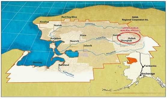
The Upper Kobuk Mineral Projects (UKMP) which encompass the Bornite deposit and the previously reported Arctic deposit are located approximately 160 miles (260 km) east of Kotzebue, Alaska, and 285 miles (460 km) northwest of Fairbanks Alaska (Figure 4-1). The closest village is the community of Kobuk, approximately 10.5 miles (17 km) to the south, situated along the banks of the Kobuk River.
FIGURE 4-1: LOCATION MAP OF THE UKMP – NORTHWEST ALASKA
The Bornite prospect and resource area is located in the USGS Ambler River A-2 quadrangle, Kateel River Meridian T 8N, R 9S, sections 4, 5, 8, and 9, with additional exploration activity throughout the Cosmos Hills.
| 4.1 |
Property Description and Location |
Upper Kobuk Mineral Projects
The UKMP shown in Figure 4-2 constitute a land package of approximately 352,943 acres (143,191 hectares) and is governed by the Northwest Alaskan Native Association (NANA) Agreement which provides a framework for exploration and resource development of the UKMP lands.
| Page 4-1 |
| January 31, 2013 |
|
UPPER KOBUK MINERAL PROJECTS |
| BORNITE DEPOSIT – SOUTH REEF AND RUBY CREEK ZONES | |
| ALASKA, USA | |
| NI 43-101 TECHNICAL REPORT | |
The UKMP are an amalgamation of: NovaCopper’s Ambler lands, comprising 112,058 acres (45,348 hectares) of State of Alaska mining claims and Federal patented mining claims located in the Ambler mining district of the southern Brooks Range of Northwestern Alaska; and NANA’s Bornite and ANCSA lands as outlined in the NANA Agreement, comprising 240,885 acres (97,483 hectares). The Bornite deposit which is the basis for this NI 43-101 Technical Report is located on NANA lands.
FIGURE 4-2: UPPER KOBUK MINERAL PROJECTS LANDS

| 4.2 |
Property Agreements |
The NANA Agreement (Ambler, Bornite, and ANCSA Lands)
The NANA Agreement which governs the exploration and future development of the UKMP lands provides that NANA grants NovaCopper US the nonexclusive right to enter, and the exclusive right to explore, the Bornite lands and certain ANCSA lands as defined in the agreement and to construct and use temporary access roads, camps, airstrips, and other incidental works. In consideration for this right, NovaCopper US paid NANA US$4 million. Under the agreement, NovaCopper US will also be required to make payments to NANA for scholarship purposes and it has agreed to use reasonable commercial efforts to train and employ NANA shareholders in connection with its operations on the UKMP Lands.
| Page 4-2 |
| January 31, 2013 |
|
UPPER KOBUK MINERAL PROJECTS |
| BORNITE DEPOSIT – SOUTH REEF AND RUBY CREEK ZONES | |
| ALASKA, USA | |
| NI 43-101 TECHNICAL REPORT | |
The NANA Agreement has a term of 20 years, with an option in favour of NovaCopper to extend the term for an additional ten years. The NANA Agreement may be terminated by mutual agreement of the parties or by NANA if NovaCopper does not meet certain expenditure requirements for the Bornite Lands and ANCSA Lands.
Under the agreement, NovaCopper is required to notify NANA of the following: the receipt of a feasibility study on a specific project; the release of a draft environmental impact statement (EIS) for public comment; or, a decision by NovaCopper to proceed with construction of a mine on UKMP Lands. Once notified, NANA will have 120 days to either: (a) exercise a non-transferrable back-in-right to acquire between 16% and 25% (as specified by NANA) of the specific project; or, (b) not exercise its back-in-rights, and instead receive a net proceeds royalty equal to 15% of the net proceeds realized by NovaCopper from the specific project. The cost to exercise the back-in-right is equal to the percentage interest in the project elected by NANA multiplied by the difference between all costs incurred by NovaCopper on the project, including historical costs incurred prior to the date of the NANA Agreement together with interest on the historical costs less US$40 million which is not less than zero. This amount will be payable by NANA to NovaCopper at the time the parties enter into a joint venture agreement on the specific project.
In the event that NANA elects to exercise its back-in-right, the parties will form a joint venture: NANA’s interest will be between 16% and 25% and NovaCopper’s interest will be the balance of the total interest in the joint venture. Upon formation of the joint venture, the joint venture will assume all of the obligations of NovaCopper and be entitled to all the benefits of NovaCopper under the NANA Agreement in connection with the mine to be developed. A party’s failure to pay its proportionate share of costs in connection with the joint venture will result in dilution of its interest. Each party will have a right of first refusal over any proposed transfer of the other party’s interest in the joint venture other than to an affiliate or for the purposes of granting security. A transfer by NANA of the net smelter royalty (NSR) return or any net proceeds interest in a project, other than for financing purposes, will also be subject to a first right of refusal in favour of NovaCopper.
In connection with possible development on the Bornite lands or ANCSA lands, NovaCopper and NANA will execute a mining lease to allow NovaCopper or the joint venture to construct and operate a mine on the Bornite or ANCSA lands. These leases will provide NANA a 2% NSR as to production from the Bornite lands and a 2.5% NSR as to production from the ANCSA Lands. If NovaCopper decides to proceed with the construction of a mine on the Ambler Lands, NANA will enter into a surface-use agreement with NovaCopper which will give NovaCopper access to the Ambler lands along routes approved by NANA. In considering such surface-use rights, NovaCopper US will grant NANA a 1% NSR on production and an annual payment of US$755 per acre (as adjusted for inflation each year, beginning with the second anniversary of the effective date of the NANA Agreement and for each of the first 400 acres, and US$100 for each additional acre) of the lands owned by NANA and used for access which are disturbed and not reclaimed.
| Page 4-3 |
| January 31, 2013 |
|
UPPER KOBUK MINERAL PROJECTS |
| BORNITE DEPOSIT – SOUTH REEF AND RUBY CREEK ZONES | |
| ALASKA, USA | |
| NI 43-101 TECHNICAL REPORT | |
NovaCopper and NANA have formed an Oversight Committee which consists of four representatives each from NovaCopper and NANA. The Oversight Committee is responsible for certain planning and oversight matters carried out by NovaCopper under the NANA Agreement. The planning and oversight matters that are the subject of the NANA Agreement will be determined by majority vote. The representatives from NovaCopper US and NANA that attend a meeting will have one vote in the aggregate and, in the event of a tie, the NovaCopper representatives will jointly have a casting vote on all matters other than Sustainability Matters, as that term is defined in the NANA Agreement. There shall be no casting vote with respect to Sustainability Matters and NovaCopper may not proceed with such matters without the consent of NANA, such consent not to be unreasonably withheld or delayed.
Alaska Gold-NovaCopper Purchase Agreement (Ambler Lands)
The Ambler lands were acquired on October 17, 2011 by NovaCopper US through a purchase and sale agreement between the Alaska Gold Company LLC (AGC) and Nova Copper US, both wholly-owned subsidiaries of NovaGold Resources Inc. (NovaGold) at the time. NovaGold is a precious metals company engaged in the exploration and development of mineral properties in North America with a portfolio of mineral properties located principally in Alaska and British Columbia. On October 24, 2011, NovaGold transferred its ownership of NovaCopper US to NovaCopper Inc., also a wholly-owned subsidiary of NovaGold, in exchange for shares of NovaCopper.
NovaGold-Kennecott Exploration and Purchase Agreements (Ambler Lands)
An exploration agreement between Kennecott Arctic Company (Kennecott) and NovaGold, under which NovaGold had the ability to earn a 51% interest in the Ambler lands, was signed on March 22, 2004. Between 2004 and 2009, NovaGold conducted project and regional level mapping, geophysical and geochemical surveys, and drilling on Ambler lands.
Under a purchase agreement dated December 18, 2009 between NovaGold, its wholly-owned subsidiary Alaska Gold Company, Kennecott Exploration Company, and Kennecott Arctic Company, NovaGold agreed to pay Kennecott a total purchase price of US$29 million for a 100% interest in the Ambler lands, to be paid as follows: US$5 million by issuing 931,098 NovaGold shares and two instalments of US$12 million in cash, each due 12 months and 24 months, respectively, from the closing date of January 7, 2010. Kennecott retained a security interest in the Ambler lands to secure these cash payments. The NovaGold shares were issued in January 2010: the first US$12 million payment was made on January 7, 2011, and the second US$12 million payment was made early on August 5, 2011, thereby completing NovaGold’s obligations under the agreement. Kennecott released its security interest and retains a 1% NSR royalty that is purchasable at any time by NovaCopper for a one-time payment of US$10 million.
| Page 4-4 |
| January 31, 2013 |
|
UPPER KOBUK MINERAL PROJECTS |
| BORNITE DEPOSIT – SOUTH REEF AND RUBY CREEK ZONES | |
| ALASKA, USA | |
| NI 43-101 TECHNICAL REPORT | |
| 4.3 |
Mineral Tenure |
Bornite and ANCSA Lands
In 1971, the United States Congress passed the Alaska Native Claims Settlement Act (ANCSA) which settled land and financial claims made by the Alaska Natives and provided for the establishment of 13 regional corporations to administer those claims. These are known as the Alaska Native Regional Corporations. One of these 13 regional corporations was the Northwest Alaskan Native Association (NANA) Regional Corporation. NANA holds the mineral rights as fee simple land for Bornite and ANCSA lands as defined in the NANA Agreement and shown in Figure 4-2. The Bornite deposit, the focus of this Technical Report, is located exclusively on lands owned by NANA.
Ambler Project Lands
The Ambler land's portion of the Upper Kobuk Mineral Projects (UKMP) comprises 112,058 acres (45,348 hectares) of State of Alaska mining claims and US Federal patented mining claims in the Kotzebue Recording District. The Ambler land tenure consists of 1,356 contiguous claims, including: 875 40-acre State claims, 481 160-acre State claims, and two Federal patented claims comprising 272 acres (20 acres is equivalent to 8 hectares). There are no fees for the Federal patented claims. Annual labour which is bankable for up to four years is US$100/40 acre State claim or US$400/160 acre State claim. Rent for each State claim is paid annually to the Alaska Department of Natural Resources (DNR). Estimated State rental payments are US$241,840 per year. There is no expiration date on State claims unless rent or labour requirements are not met. In addition, the UKMP property border is within 25 km of National Park lands.
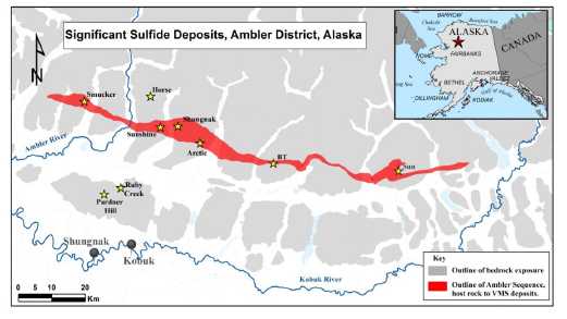
The Ambler mining district contains many mineralized prospects and two known significant deposits, in addition to the Arctic and Bornite deposits of the UKMP. Figure 4-3 shows the Ambler Claim group and most of the significant mineral occurrences in the district.
| Page 4-5 |
| January 31, 2013 |
|
UPPER KOBUK MINERAL PROJECTS |
| BORNITE DEPOSIT – SOUTH REEF AND RUBY CREEK ZONES | |
| ALASKA, USA | |
| NI 43-101 TECHNICAL REPORT | |
FIGURE 4-3: STATE AND FEDERAL CLAIMS OF THE UPPER KOBUK MINERAL PROJECTS

Figure 4-3 also shows the location of the majority of known prospects and deposits of the UKMP, including: Arctic, Sunshine, Horse, Cliff, Shungnak, and BT in the Ambler Schist Belt, and Aurora Mountain, Pardner Hill, and Bornite in the Bornite Carbonate sequence. Historically, the Bornite prospect has also been known as the Ruby Creek deposit.
In addition to the UKMP deposits and occurrences, two additional deposits of note occur in the Ambler Schist Belt rocks. The first prospect, located west of the Ambler claim group, is the Smucker deposit owned by Teck Cominco Limited (Teck Cominco), and is currently in a target delineation phase. The second prospect, located east of the UKMP Ambler claims, is the Sun deposit owned by Andover Ventures Inc. (Andover). Both targets have historically reported resources. Figure 4-4 shows the locations of the Sun and Smucker deposits in relation to the UKMP deposits and occurrences.
| Page 4-6 |
| January 31, 2013 |
|
UPPER KOBUK MINERAL PROJECTS |
| BORNITE DEPOSIT – SOUTH REEF AND RUBY CREEK ZONES | |
| ALASKA, USA | |
| NI 43-101 TECHNICAL REPORT | |
| Figure 4-4: Sun and Smucker Deposits in Relation to the Ambler District Mineral Occurrences |
| 4.4 |
Surface Rights |
Surface rights and access to the Bornite and ANCSA Lands are governed according to the NANA Agreement which provides NovaCopper with the nonexclusive right to enter, and the exclusive right to explore, the lands and to also construct and use temporary access roads, camps, airstrips, and other incidental works.
| 4.5 |
Royalties |
Under the terms of the NANA Agreement, if NovaCopper decides to proceed with construction of a mine on the Bornite, ANCSA, or Ambler Lands, NANA will have an opportunity to either: exercise a non-transferrable back-in-right to acquire between 16% and 25% (as specified by NANA) of the specific project subject to payment of its cost; or, not exercise its back-in-rights, and instead receive a net proceeds royalty equal to 15% of the net proceeds from the specific project. The cost for NANA to exercise such back-in-rights is summarized in Section 4.2.
In addition, the NANA Agreement defines a surface-use agreement with NovaCopper which affords NovaCopper access to the Ambler Lands along routes approved by NANA. In considering such surface-use rights, NovaCopper will grant NANA a 1% NSR on production and annual payments as outlined in Section 4.2. In addition to those royalties that may impact the potential development of resources at the Bornite deposit, Kennecott retains a 1% NSR royalty on Ambler Lands as defined under the 2009 purchase agreement with NovaGold. That NSR is purchasable at any time for a one-time payment of US$10 million.
| Page 4-7 |
| January 31, 2013 |
|
UPPER KOBUK MINERAL PROJECTS |
| BORNITE DEPOSIT – SOUTH REEF AND RUBY CREEK ZONES | |
| ALASKA, USA | |
| NI 43-101 TECHNICAL REPORT | |
| 4.6 |
Exploration Permits |
Multiple permits are required during the exploration phase of the Bornite Project. Permits are issued from Federal, State, and Regional agencies, including: the Environmental Protection Agency (EPA), the US Army Corps of Engineers (COE), the Alaska Department of Environmental Conservation (ADEC), the Alaska Department of Fish and Game (ADF&G), the Alaska Department of Natural Resources (ADNR), the (ADOR), and the Northwest Arctic Borough (NWAB). The Annual Hardrock Exploration Permit (AHEA) issued by ADNR's Division of Mining, Land, and Water is a multi-year permit that is valid for up to five years. The AHEA is a multi-agency permit that includes various Nationwide Permits issued by the COE, a Title 16 Fish Habitat Permit issued by the ADF&G, a Temporary Water Use Permit issued by the ADNR, and a mining license issued by the ADOR. NovaCopper or NovaGold has retained a valid AHEA permit since 2011. The EPA requires a Spill Prevention, Control, and Countermeasures (SPCC) plan for bulk fuel storage of greater than 1,320 gallons. NovaCopper or NovaGold has retained a valid SPCC plan since 2010. Due to the location of the Bornite Project within the Northwest Arctic Borough, several Title 9 Miscellaneous Land Use permits are required, including permits for mineral exploration, bulk fuel storage, use of airstrips, and establishment of camps. NovaCopper or NovaGold has retained Title 9 Permits since 2004. Project support is provided by the Bornite Camp including the Bornite Camp Landfill. Bornite Camp and Landfill are permitted through the ADEC and permits have been retained since 2011 and 2012, respectively. Year-end reclamation reports must be submitted to the ADNR and the NWAB which outline areas of ground disturbances and reclamation. A number of statutory reports and payments are required to keep the claims in good standing on annual basis.
| 4.7 |
Environmental Liabilities |
Under the NANA Agreement, NANA is required to complete a baseline environmental report following the cleanup of the former mining camp on the Bornite Lands; this must be completed to Alaska Department of Environmental Conservation standards. Cleanup includes the removal and disposal, as required by law, of all hazardous substances present on the Bornite Lands. NANA has indemnified and will hold NovaCopper harmless for any loss, cost, expense, or damage suffered or incurred attributable to the environmental condition of the Bornite Lands at the date of the baseline report which relate to any activities prior to the date of the agreement.
| Page 4-8 |
| January 31, 2013 |
|
UPPER KOBUK MINERAL PROJECTS |
| BORNITE DEPOSIT – SOUTH REEF AND RUBY CREEK ZONES | |
| ALASKA, USA | |
| NI 43-101 TECHNICAL REPORT | |
In addition, there are no indications of any known environmental impairment or enforcement actions associated with NovaGold’s activities to date. As a result, NovaGold, now NovaCopper has not incurred outstanding environmental liabilities in conjunction with its entry into the NANA Agreement.
| Page 4-9 |
| January 31, 2013 |
|
UPPER KOBUK MINERAL PROJECTS |
| BORNITE DEPOSIT – SOUTH REEF AND RUBY CREEK ZONES | |
| ALASKA, USA | |
| NI 43-101 TECHNICAL REPORT | |
| 5 |
ACCESSIBILITY, CLIMATE, LOCAL RESOURCES, INFRASTRUCTURE, AND PHYSIOGRAPHY |
| 5.1 |
Accessibility |
The Bornite deposit is located in Northwest Alaska in the Cosmos Hills on the southern flank of the Brooks Range. It is circa 67.1 ° north latitude and 156.38° west longitude, approximately 160 miles (260 km) east of Kotzebue, Alaska, and 285 miles (460 km) northwest of Fairbanks, Alaska. Kobuk is the closest community to Bornite. There is daily air service from Kotzebue to Kobuk. Sixteen miles (26 km) of improved gravel road connect Kobuk to the Bornite Camp. On the road to the Bornite Camp are the Dahl Camp and a 4,780 ft (1,460 m) airstrip. During the summer months, the Dahl Camp airstrip is suitable for larger aircraft, such as C-130 and DC-6. A second, shorter airstrip is adjacent to the Bornite Camp. This strip is more suited to smaller aircraft that support the Bornite Camp with personnel and supplies. The two other villages close to Bornite are: Shungnak, 10 miles (16 km) downriver from Kobuk, and Ambler, 30 miles (48 km) further downriver from Shungnak.
| 5.2 |
Climate |
The Bornite Camp is 40 miles (64 km) north of the Arctic Circle. Average rainfall is approximately 17 in (43 cm) per year, and snowfall is approximately 56 in (142 cm) per year. Summers are generally mild and sunny, and winters are extremely cold and dark. Extreme temperatures recorded in Kobuk, Alaska range from 90°F in summer to -68°F in winter.
Year-round exploration is not possible with the current camp facilities, so the field season is May to October. The Bornite Camp closes during winter and a caretaker is on-site during the months of November through April.
| 5.3 |
Local Resources and Infrastructure |
Except for resident personnel, the logistical resources necessary for the exploration work are limited. Most equipment and supplies are flown in by charter flights from Fairbanks or Kotzebue, Alaska. Some supplies are flown in from Anchorage, Alaska.
The main Bornite Camp facilities are located on Ruby Creek on the northern edge of the Cosmos Hills. The camp houses and provides office space for the geologists, drillers, pilots, and support staff. There are four 2-person cabins and a caretaker cabin with ten beds.
In 2011, the camp was expanded to twenty sleeping tents, three administrative tents, two shower/bathroom tents, one medical tent, and one dining/cooking tent. With these additions, the camp capacity was increased to 49 beds. A 100 ft by 30 ft core logging facility was also built in summer of 2011. Figure 5-1 shows the 2011 core logging facility.
| Page 5-1 |
| January 31, 2013 |
|
UPPER KOBUK MINERAL PROJECTS |
| BORNITE DEPOSIT – SOUTH REEF AND RUBY CREEK ZONES | |
| ALASKA, USA | |
| NI 43-101 TECHNICAL REPORT | |
In 2012, the camp was further expanded with the addition of a laundry tent, a women's shower/washroom tent, a recreation tent, several additional sleeping tents, and a twice-as-large kitchen tent. Camp capacity increased to 71 beds. The septic field was upgraded to accommodate the increase in camp population. One of the two-person cabins was winterized for use by the winter caretaker. A permitted landfill was established to allow for the continued cleanup and rehabilitation of the historic shop facilities and surroundings.
FIGURE 5-1: NOVACOPPER CORE LOGGING FACILITY

The Dahl Creek Camp is an overflow facility to the Main Bornite Camp. The Dahl Creek Camp has a main cabin for dining and administrative duties, and a shower facility. Sleeping facilities include two hard-sided sleeping areas with seven beds (primarily used for staff), two 4-person sleeping tents, and three 2-person sleeping tents for a total of 21 beds. There are support structures, including a shop and storage facilities.
| 5.4 |
Physiography |
The Bornite deposit is located on Ruby Creek on the northern edge of the Cosmos Hills. The Cosmos Hills are part of the southern flank of the Brooks Range in Northwest Alaska.
| Page 5-2 |
| January 31, 2013 |
|
UPPER KOBUK MINERAL PROJECTS |
| BORNITE DEPOSIT – SOUTH REEF AND RUBY CREEK ZONES | |
| ALASKA, USA | |
| NI 43-101 TECHNICAL REPORT | |
Topography in the area is moderately rugged. Maximum relief in the Cosmos Hills is approximately 3,300 ft (1,000 m) with an average of 1,650 to 2,300 ft (500 to 700 m). Talus covers the upper portions of the hills. Glacial and fluvial sediments occupy valleys.
Alder brush and spruce grow in protected valleys, but exposed terrain is tundra-covered. Water is abundant. Discontinuous permafrost occurs throughout the area and is more prevalent on north-facing slopes.
| 5.5 |
Sufficiency of Surface Rights |
In regard to future mining operations, sufficient space is available to locate the various facilities, including staff housing, stockpiles, tailings storage facility, waste rock storage facilities, and processing plants.
| Page 5-3 |
| January 31, 2013 |
|
UPPER KOBUK MINERAL PROJECTS |
| BORNITE DEPOSIT – SOUTH REEF AND RUBY CREEK ZONES | |
| ALASKA, USA | |
| NI 43-101 TECHNICAL REPORT | |
| 6 |
HISTORY |
| 6.1 |
Bornite Deposit History |
Kennecott and Bear Creek Mining Tenure
Regional exploration began in the early 1900s when gold prospectors noted copper occurrences in the hills north of Kobuk, Alaska. In 1947, local prospector Rhinehart “Rhiny” Berg, along with various partners traversing the area, located outcropping mineralization along Ruby Creek (Bornite) on the north side of the Cosmos Hills. They subsequently staked claims over the Ruby Creek showings and constructed an airstrip for access (http://alaskamininghalloffame.org/inductees/berg.php, Feb 14, 2012). In 1956, R. Chadwick, Kennecott Mining Company, heard about the Ruby Creek property from a Bureau of Mines employee in Nome and followed up with Rhiny Berg. In 1957, as a result of this communication, Bear Creek Mining Company (Bear Creek), Kennecott's exploration subsidiary, optioned the property from Berg.
Exploration drilling in 1961 and 1962 culminated in the discovery of the No.1 Ore Body in what is now referred to as the Upper Reef where drill hole DDH-RC-34 cut 65.6 ft (20 m) of 24% copper. The discovery of the No.1 Ore Body led to the development of an exploration shaft in 1966. The shaft which reached a depth of 1,075 ft (328 m) encountered a significant watercourse and was flooded near completion depth. The shaft was subsequently dewatered and an exploration drift was developed to provide access for sampling and mapping, and to accommodate underground drilling to further delineate the orebody. A total of 59 underground holes were drilled and, after the program, the shaft was allowed to re-flood.
In 1961, concurrent with ongoing exploration at Bornite, Bear Creek initiated preliminary metallurgical test work. A total of 32 assay reject samples from five AX diamond drill holes weighing approximately 150 lbs (68 kg) from drill holes (RC-34, RC-54, RC-60, RC-61, and RC-65) that mainly penetrated the No.1 Ore Body were submitted for analysis (Bear Creek Mining Co. Memo Lutz, 1961).
All holes were composited using weighted compositing methodology and individual samples entered the composite in proportion to the tonnage of ore represented by each sample using ore reserve data. Prior to compositing, each sample was crushed and screened to pass a 10-mesh screen. Most samples were in two parts: one contained in plastic (assumed unoxidized), and one contained in canvas (oxidized).
| Page 6-1 |
| January 31, 2013 |
|
UPPER KOBUK MINERAL PROJECTS |
| BORNITE DEPOSIT – SOUTH REEF AND RUBY CREEK ZONES | |
| ALASKA, USA | |
| NI 43-101 TECHNICAL REPORT | |
The composite sample assayed 13.9% Cu; 97.64% of the copper was recovered in a concentrate assaying 43.90% Cu after a locked-cycle laboratory test. Fine grinding to 5% passing +200-mesh was required to obtain the liberation of copper minerals from pyrite necessary for such high recovery. Composite ore mineralogy from the test work is shown in Table 6.1.
TABLE 6.1: MICROMETRIC ESTIMATES OF COPPER MINERAL DISTRIBUTION
| Ore Mineral | Percent by Weight |
Percent of Total Cu Content |
| Bornite | 44.7 | 51 |
| Chalcopyrite | 36.6 | 22.8 |
| Chalcocite | 17.7 | 25.5 |
| Tetrahedrite | 0.9 | 0.7 |
The discovery of the Arctic deposit in 1965 prompted a hiatus in exploration at Bornite. In the late 1990s, Kennecott resumed its evaluation of the Bornite deposit and the mineralization in the Cosmos Hills with an intensive soil, stream, and rock chip geochemical sampling program using 32 element ICP analysis. Grid soil sampling yielded 765 samples. Ridge and spur sampling resulted in an additional 850 soil samples in the following year. Skeletonized core samples (85 samples) from key historic drill holes were also analyzed using 32 element ICP analytical methods. Geochemical sampling identified multiple areas of elevated copper and zinc in the Bornite region (Kennecott Annual Ambler Project Reports, 1995-1997).
Kennecott completed numerous geophysical surveys as an integral part of exploration throughout their tenure on the property. Various reports, notes, figures, and data files stored in Kennecott’s Salt Lake City exploration office indicated that geophysical work included, but was not limited to, the following:
-
Airborne magnetic and electromagnetic (EM) surveys (fixed-wing INPUT) (1950s)
-
Gravity, single point (SP), Audio-Frequency Magneto-Telluric (AMT), EM, borehole and surface IP/resistivity surveys (1960s)
-
Gravity, airborne magnetic, and Controlled Source Audio-frequency Magneto- Telluric (CSAMT) surveys (1990s)
NovaCopper has little information or documentation associated with the geophysical surveys conducted prior to 1990s. Where data are available in these earlier surveys, the lack of details in data acquisition, coordinate systems, and data reduction procedures limit their usefulness. The only complete geophysical report available concerns down-hole IP/resistivity results (Merkel, 1967). Most notable is the 1996 Bouger gravity survey from the Bornite deposit into the Ambler lowlands. The Bornite deposit itself is seen as a significant 3 milligal (mGal) anomaly. Numerous 2 milligal to > 6 milligal anomalies occur under cover in the Ambler lowlands and near the Aurora Mountain and Pardner Hill occurrences. Figure 6-1 shows the correct Bouger residual gravity survey anomalies.
| Page 6-2 |
| January 31, 2013 |
|
UPPER KOBUK MINERAL PROJECTS |
| BORNITE DEPOSIT – SOUTH REEF AND RUBY CREEK ZONES | |
| ALASKA, USA | |
| NI 43-101 TECHNICAL REPORT | |
FIGURE 6-1: 1996 KENNECOTT RESIDUAL GRAVITY

The wide range of geophysical techniques used in and around the deposit over a span of 40 years indicates the level of difficulty experienced by Kennecott/Bear Creek while trying to detect ore. When applying EM and IP/resistivity methods, the problem appears to be that deeper mineralization is often masked by the response of near-surface conductive and polarizable rocks.
In addition to the geophysical surveys conducted by Kennecott, the Alaska Department of Natural Resources and Geometries completed an aeromagnetic survey of portions of the Ambler district in 1974-1975. Part of this survey is reproduced in Figure 16 (Gilbert et al., 1977).
| Page 6-3 |
| January 31, 2013 |
|
UPPER KOBUK MINERAL PROJECTS |
| BORNITE DEPOSIT – SOUTH REEF AND RUBY CREEK ZONES | |
| ALASKA, USA | |
| NI 43-101 TECHNICAL REPORT | |
Kennecott Ambler District Exploration
Concurrent with the ongoing work at Bornite (specifically Ruby Creek), Bear Creek mounted an aggressive regional exploration program that began in 1962 in the Cosmos Hills and adjacent Ambler Schist Belt.
In 1965, while re-evaluating a 1,400 ppm copper geochemical anomaly from sampling completed in 1963, Bear Creek geologists discovered sulphides in float on the east side of Arctic Ridge, a short distance below the crest of the ridge. Eight core holes were drilled in 1967 intersecting massive sulphide mineralization over a 1,500 ft strike length. Initial results were sufficiently encouraging and Bear Creek changed their focused from the Bornite (Ruby Creek) mineralization to the Arctic deposit. Bear Creek subsequently drilled 84 core holes at Arctic totalling 51,472 ft (15,689 m) from August, 1967 to July, 1985.
In 1973, a claim-staking war began which lasted more than two years: Anaconda, Noranda, WGM, and Sunshine Mining entered the Ambler District. Bear Creek and its competitors discovered several other prospects, including two potential deposits (Sun and Smucker). Both the Bornite (Ruby Creek) and Arctic deposits received patents on the core claim groups. However, the relative inaccessibility of the Ambler District, along with depressed metals prices, caused interest in the district to wane and any significant exploration or development activity in the district ended in 1985. In 1987, Cominco acquired the claims covering the Sun and Smucker deposits from Anaconda. In 1989, Kennecott sold its Bornite (Ruby Creek) deposit and the surface development at Bornite to NANA. The area's inaccessibility remains the single largest obstacle in the development of the Ambler District.
In 1993, after negotiating an agreement with NANA Regional Corporation, Kennecott Minerals began a re-evaluation of the Arctic deposit that included reinterpretation of the geology of the deposit and the assembly of a computer database. In 1995, a computer-generated block model was constructed and an updated mineral resource estimate was calculated using the block model. In September 1997, a total of 2,035 State of Alaska claims were located; these covered most of the known Ambler Schist Belt rocks.
NovaGold Tenure - Ambler Mining District
An exploration agreement between Kennecott Arctic Company and NovaGold under which NovaGold had the ability to earn a 51% interest in the Ambler lands was signed on March 22, 2004. Between 2004 and 2009, NovaGold conducted project and regional level mapping, geophysical and geochemical surveys, and drilling on Ambler lands.
| Page 6-4 |
| January 31, 2013 |
|
UPPER KOBUK MINERAL PROJECTS |
| BORNITE DEPOSIT – SOUTH REEF AND RUBY CREEK ZONES | |
| ALASKA, USA | |
| NI 43-101 TECHNICAL REPORT | |
Under a purchase agreement dated December 18, 2009 between NovaGold, its wholly-owned subsidiary Alaska Gold Company, Kennecott Exploration Company, and Kennecott Arctic Company, NovaGold agreed to pay Kennecott a total purchase price of US$29 million for a 100% interest in the Ambler lands. On August 5, 2011, NovaGold made the final payment thereby completing NovaGold’s obligations under the purchase agreement.
| 6.2 |
Bornite Historical Resource Estimations |
All of the historic resource estimates presented in Section 6.2 were made prior to the implementation of NI 43-101. They do not conform to NI 43-101 reporting standards and should not be interpreted as such. They are presented here for information purposes only.
Although Kennecott and NANA have released no NI 43-101 compliant resource estimates, a series of historical resources have been compiled for the Bornite property. The earliest and most widely repeated resource estimate is from Lund (1961), shown in Table 6.2, who reported 91 million tons at 1.2% Cu in an unconstrained polygonal resource estimate. At a constrained 1% Cu cut-off grade, Lund reported 21.2 million tons of 3.04% Cu, and at a 2.5% Cu cut-off grade, Lund reported 5.2 million tons of 5.83% Cu. This estimation is based on an 11.0 ft3/ton tonnage factor for the lower grade Lower Reef mineralization, and a 10.0 ft3/ton tonnage factor for the higher-grade Upper Reef mineralization. It is not known if the tonnage factors were based on any direct specific gravity measurements of the Bornite drill core. Metals, such as silver and cobalt, were not considered and were not included in any of the historical estimations (Robinson, 2010).
TABLE 6.2: BORNITE HISTORICAL RESOURCE (LUND, 1961)
Ore Body |
2.5% Cu Cut-off | 1% Cu Cut-off | ||
| Tonnage (M tons) |
Grade (Cu%) |
Tonnage (M tons) |
Grade (Cu%) | |
| No. 1 | 1.71 | 10.6 | 3.35 | 8.6 |
| No. 2 | 0.52 | 4.8 | 2.45 | 2.3 |
| No. 3 | 1.5 | 1.6 | ||
| No. 4 | 2.47 | 3 | 8.55 | 2.1 |
| No. 5 | 0.33 | 4.7 | 3.28 | 1.9 |
| No. 6 | 0.14 | 4.1 | 1.33 | 1.7 |
| No. 7 | 0.77 | 1.7 | ||
| TOTAL | 5.17 | 5.83 | 21.23 | 3.04 |
As reported by Robinson (2010), another historical resource estimate was completed in 1968 for the No.1 Ore Body by C.T. Penney. The unverified estimate is 180,000-200,000 tons at 8.4% Cu. A second resource estimate by Reed in 1971 and shown in Table 6.3, is summarized in Kennecott's annual reports for the project. As with Penny's resource, the details of the estimation could not be verified. This estimation was apparently tabulated using a grade times thickness cut-off criterion.
| Page 6-5 |
| January 31, 2013 |
|
UPPER KOBUK MINERAL PROJECTS |
| BORNITE DEPOSIT – SOUTH REEF AND RUBY CREEK ZONES | |
| ALASKA, USA | |
| NI 43-101 TECHNICAL REPORT | |
TABLE 6.3: BORNITE HISTORICAL RESOURCE (REED, 1971)
| Ore Body |
Tonnage (M tons) |
Grade (Cu%) |
| Upper Reef | 15.4 | 2.6 |
| Lower Reef | 20.2 | 1.8 |
| TOTAL | 35.6 | 2.15 |
In the late 1970s, Bear Creek restated the 5.17 million ton resource, including the No. 1 Ore Body and other unnamed bodies of high-grade ore east and west of the shaft (Figure I, Bernstein and Cox, 1986).
In 1974, Sichermann completed another internal Kennecott resource estimate for Bornite; results are shown in Table 6.4. The estimation using a polygonal methodology is not considered entirely accurate as down-hole surveys were not available for all drill holes (Sichermann, 1974). Sichermann recognized that the ore (mineralized) lenses where erratic; however, in total, Sichermann felt that the resource was “a reasonable approximation of the potential of the two reefs.” Sichermann used a 10.5 ft3/ton tonnage factor for >1% Cu mineralization and an 8.0 ft3/ton tonnage factor for >4% Cu mineralization.
TABLE 6.4: BORNITE HISTORICAL RESOURCE (SICHERMANN, 1974)
| Ore Body |
4% Cu Cut-off | 1% Cu Cut-off | ||
| Tonnage (M tons) |
Grade (Cu %) |
Tonnage (M tons) |
Grade (Cu %) | |
| Upper Reef | 4.5 | 11.52 | 18.9 | 3.16 |
| Lower Reef | 18.7 | 1.92 | ||
| TOTAL | 4.5 | 11.5 | 37.6 | 2.54 |
Two different resource estimates appear in Bundtzen et al. (1996), and in earlier editions of the DGGS Special Report series published by the State of Alaska. These estimations report 5 million tons (4.56 million tonnes) at 4% Cu and 40 million tons (36.2 million tonnes) at 2% Cu, respectively, without reporting cut-off grades. The sources of these estimations are unknown.
In 1997, Macfarlane conducted a more rigorous resource estimation of the Ruby Creek (Bornite) deposit for Kennecott. This estimation used Vulcan 3D modelling and resource estimation software. A series of grade shells at 0.2%, 0.5% and 1.0% Cu were manually constructed on sections and imported into Vulcan. Within each shell, separate resource calculations at 0.5%, 1.0%, 2%, and 4.0% Cu cut-off grades were made. The grade shells were constructed irrespective of various lithologies or mineralization styles. Attempts to create meaningful semi-variograms for copper mineralization were unsuccessful; the author concluded, “This is not surprising since different ore and host types have been mixed, a lack of consistency in drill direction, and a relatively widely spaced drilling grid.” Lacking useful semi-variograms, the author reverted to an inverse-distance-squared weighting methodology to estimate the resource. Results of the estimation are shown in Table 6.5.
| Page 6-6 |
| January 31, 2013 |
|
UPPER KOBUK MINERAL PROJECTS |
| BORNITE DEPOSIT – SOUTH REEF AND RUBY CREEK ZONES | |
| ALASKA, USA | |
| NI 43-101 TECHNICAL REPORT | |
TABLE 6.5: BORNITE HISTORICAL RESOURCE (KENNECOTT, 1997)
| Cut-off (% Cu) |
0.2% Grade shell | 0.5% Grade shell | 1% Grade shell | |||
| Tonnage (Mtonnes) |
Grade (Cu %) |
Tonnage (Mtonnes) |
Grade (Cu %) |
Tonnage (Mtonnes) |
Grade (Cu %) | |
| 0.5 | 71.6 | 1.24 | 40.5 | 1.41 | 17.1 | 2.02 |
| 1.0 | 27.0 | 2.09 | 22.3 | 1.92 | 14.2 | 2.26 |
| 2.0 | 6.6 | 4.48 | 4.7 | 4.02 | 4.0 | 4.39 |
| 4.0 | 2.2 | 8.06 | 1.5 | 7.15 | 1.1 | 9.54 |
An approximation of the specific gravity, based on the relationship of copper grade to specific gravity, was supplied by Kennecott as shown in Table 6.6. No support for Table 6.6 is presented. The author recognized that the tonnages for massive pyrite areas with low grade copper zones were significantly underestimated.
TABLE 6.6: SPECIFIC GRAVITY USED IN 1997 HISTORICAL KENNECOTT RESOURCE ESTIMATE
| %Cu | SG |
| <0.5 | 2.8 |
| 0.5 – 1 | 2.9 |
| 1 – 2 | 3.0 |
| 2 – 3 | 3.2 |
| 3 – 4 | 3.5 |
| 4 – 5 | 3.8 |
| 5 – 10 | 4.0 |
| 10 – 15 | 4.2 |
| 15 – 20 | 4.4 |
| >20 | 4.6 |
| Page 6-7 |
| January 31, 2013 |
|
UPPER KOBUK MINERAL PROJECTS |
| BORNITE DEPOSIT – SOUTH REEF AND RUBY CREEK ZONES | |
| ALASKA, USA | |
| NI 43-101 TECHNICAL REPORT | |
| 7 |
GEOLOGICAL SETTING AND MINERALIZATION |
| 7.1 |
Regional Geology |
The Bornite Project is located within the Arctic Alaska Terrane, a sequence of mostly Paleozoic continental margin rocks that make up the Brooks Range and North Slope of Alaska (Moore, 1992). It is within the Phyllite Belt geologic subdivision, which together with the higher-grade Schist Belt, stretches almost the entire length of the Brooks Range and is considered to represent the hinterland of the Jurassic Brooks Range orogeny. The southern margin of the Phyllite Belt is marked by melange and low angle faults associated with the Kobuk River fault zone, while the northern boundary is thought to be gradational with the higher-grade metamorphic rocks of the Schist Belt (Till et al., 2008).
| 7.2 |
Tectonic and Metamorphic History |
The tectonic setting of the project area during mineralization (early Devonian) has been masked by subsequent deformation and remains poorly understood. Dillon et al. (1980) interpret the existence of Devonian granites throughout the Brooks Range as supporting a volcanic arc environment, while Hitzman et al. (1986) point to bimodal volcanic rocks and abrupt sedimentary facies transitions as supporting an extensional tectonic setting. Based on igneous geochemistry, Ratterman et al. (2006) suggest that the Ambler sequence volcanic rocks were emplaced in an extensional back-arc spreading environment; however, the original pre-deformation spatial relationship between the Bornite Project area and the Ambler sequence is still poorly understood.
The project area underwent regional deformation and metamorphism during the Middle Jurassic to Early Cretaceous Brooks Range orogeny. The collision of the Koyukuk Arc Terrane from present-day south caused north-directed imbrication and partial subduction of the Arctic Alaska passive margin sedimentary sequence. Rocks in the Schist Belt were metamorphosed to blueschist facies but were partially exhumed by north-directed faulting prior to full thermal equilibration. Both the Schist Belt and the Phyllite Belt cooled from greenschist conditions during a period of rapid extension and erosion beginning around 103 Ma (Moore et al., 1994, Vogl et al., 2003).
In the project area, a strand of the Kobuk fault zone separates the Cosmos Hills stratigraphy (Schist Belt and Phyllite Belt) from the overlying Angayucham Terrane, and another strand may separate Cosmos Hills from the Ambler sequence to the north (Figure 7-1).
| Page 7-1 |
| January 31, 2013 |
|
UPPER KOBUK MINERAL PROJECTS |
| BORNITE DEPOSIT – SOUTH REEF AND RUBY CREEK ZONES | |
| ALASKA, USA | |
| NI 43-101 TECHNICAL REPORT | |
FIGURE 7-1: GENERALIZED
GEOLOGIC MAP OF THE COSMOS
HILLS
(MODIFIED FROM TILL ET
AL., 2008)

| 7.2.1 |
Regional Stratigraphy |
The autochthonous stratigraphy of the district is characterized by lower greenschist to epidote-amphibolite facies, pelitic, carbonate, and local metavolcanic rocks as shown in Figure 7-1 and summarized in Table 7.1.
| Page 7-2 |
| January 31, 2013 |
|
UPPER KOBUK MINERAL PROJECTS |
| BORNITE DEPOSIT – SOUTH REEF AND RUBY CREEK ZONES | |
| ALASKA, USA | |
| NI 43-101 TECHNICAL REPORT | |
TABLE 7.1: STRATIGRAPHIC
UNITS OF THE COSMOS HILLS
AREA
(MODIFIED FROM HITZMAN ET AL., 1986)
| Unit (age) |
Lithology |
Metamorphic
grade |
Approximate
thickness |
| Shungnak conglomerate (Cretaceous) |
Pebble conglomerate, sandstone, siltstone, minor intermediate volcanics |
Unmetamorphosed |
1000m |
| Angayucham terrane
(Devonian-Mississippian) (allochthonous) |
Pillow basalt, pillow breccia |
Prehnite- Pumpellyite |
>500m |
| Beaver Creek phyllite
(Devonian*) |
Phyllite, quartzite, marble | Lower Greenschist | >2000m |
Ambler sequence (Devonian*) |
Metarhyolite, metabasite,
tuffaceous metasediments, calcareous metasediments, pelitic schist |
Blueschist to Greenschist |
700-1850m |
| Bornite carbonate
sequence (Lower Devonian to Upper Silurian*) |
Marble, argillaceous
marble, dolostone, phyllite, phyllitic marble |
Lower Greenschist | 200-1000m |
| Anirak schist (Devonian*) |
Pelitic schist, quartzite,
marble, minor metabasite |
Greenschist |
3000m |
| Kogoluktuk schist (Precambrian to Devonian*) |
Pelitic schist, quartzite, metagabbro, minor marble |
Epidote-Amphibolite |
4000m |
*Ages from Till et al., 2008
| 7.2.2 |
Igneous Rocks |
The intersection of the Cosmos Arch and the Kogoluktuk River drainage 9 miles (14 km) southeast of Bornite exposes a cataclastic orthogneiss of granitic composition which intrudes the Kogoluktuk Schist. Zircons return a syn-mineral uranium-lead age of 386 ± 3 Ma (Till et al., 2008, citing W.C. McClelland).
Higher in the section, the Kogoluktuk Schist is also intruded by sill-form metagabbro bodies of unknown age. Other metamafic ‘greenstones’ are interpreted to have originated as flows and/or tuffaceous sediments (Hitzman, 1986).
| Page 7-3 |
| January 31, 2013 |
|
UPPER KOBUK MINERAL PROJECTS |
| BORNITE DEPOSIT – SOUTH REEF AND RUBY CREEK ZONES | |
| ALASKA, USA | |
| NI 43-101 TECHNICAL REPORT | |
Although none occur in the Bornite resource area, discontinuous stratabound greenstone bodies occur in the Anirak Schist and at the base of the Bornite carbonate sequence, particularly west and southwest of Bornite (Hitzman et al., 1982). A gabbroic outcrop approximately 650 ft (200 m) in width outcrops 1.2 miles (2 km) east of Bornite and is interpreted to be Cretaceous to Tertiary in age.
The most significant igneous rocks in the district are the bimodal volcanic rocks of the Ambler sequence—host of the Ambler VMS district—which outcrop 12 miles (20 km) north of Bornite, but are not observed in the Cosmos Hills (Table 7.1). These include sub-alkaline basaltic flows and sills with an undepleted mantle geochemical signature. Sub-alkaline rhyolitic to andesitic tuffs and flows have geochemistry consistent with formation from a source that includes melting continental crust. Geochemistry collectively implies origin in an extensional, back-arc basin setting (Ratterman et al., 2006). Uranium-lead zircon dating from Ambler sequence metarhyolites returns ages of 376-387 Ma (McClelland et al., 2006), which are syn- to early post-mineral with respect to the Bornite (Ruby Creek) deposit.
| 7.2.3 |
Timing of Mineralization in the District |
Sulphide mineralization (chalcopyrite, pyrite, and bornite) from Bornite (Ruby Creek) was dated by Re-Os techniques (Selby et al., 2009), producing an age of 384 ± 4.2 Ma for main stage copper mineralization.
The syngenetic VMS deposits in the Ambler sequence are constrained by dating of related felsic volcanic rocks. Early post-mineral metarhyolite at the Arctic prospect yielded a mean uranium-lead zircon age of 378 ± 2Ma. Uranium-lead zircon ages for metarhyolite at the Tom-Tom prospect, 7 miles (11 km) east of Arctic, and the Sun prospect, 36 miles (60 km) east of Arctic, are 381 ± 2 Ma and 386 ± 2 Ma, respectively (McClelland et al., 2006). Since the VMS deposits and Bornite deposit may have a common fluid source, the potential scale of Bornite type mineralization may be much larger than the reefs delineated by current drilling.
| 7.3 |
Deposit Geology |
The geology of the Bornite resource area is composed of alternating beds of carbonate rocks (limestone and dolostone) and calcareous phyllite. Limestone transitions laterally into dolostone, which hosts the majority of the mineralization and is considered to be hydrothermal in origin. Spatial relationships and petrographic work establish dolomitization as genetically related to early stages of the copper mineralizing system (Hitzman, 1986).
| Page 7-4 |
| January 31, 2013 |
|
UPPER KOBUK MINERAL PROJECTS |
| BORNITE DEPOSIT – SOUTH REEF AND RUBY CREEK ZONES | |
| ALASKA, USA | |
| NI 43-101 TECHNICAL REPORT | |
NovaCopper geologists have been unable to identify any meta-igneous rocks in the resource area; all lithologies described are interpreted as metasedimentary in origin.
| 7.3.1 |
Lithology Units |
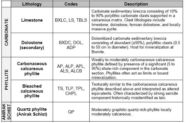
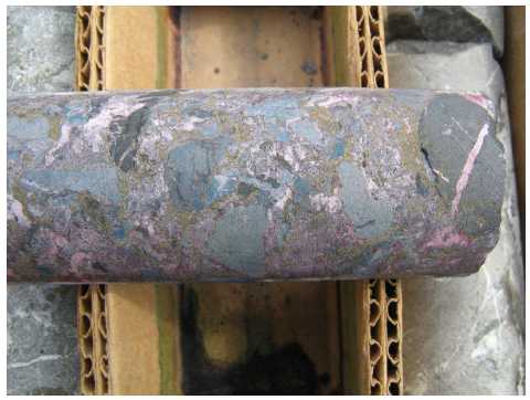
The current lithology system derives from early Bear Creek Mining Company core logs (1960). Original unit descriptions have not been found; however, the units were re-described during re-logging by NovaGold geologists in the summer of 2010. The scheme encompasses not only primary lithology, but also alteration, and compositional and textural variations. Resource-scale geologic interpretation and modelling is based on the hierarchical generalization shown with condensed descriptions in Table 7.2. Figure 7-2 shows typical dolomitized sedimentary breccias of the Bornite carbonate sequence, which are the principal host of mineralization at Bornite.
TABLE 7.2: LITHOLOGY UNITS ON THE BORNITE PROPERTY
| Page 7-5 |
| January 31, 2013 |
|
UPPER KOBUK MINERAL PROJECTS |
| BORNITE DEPOSIT – SOUTH REEF AND RUBY CREEK ZONES | |
| ALASKA, USA | |
| NI 43-101 TECHNICAL REPORT | |
FIGURE 7-2: A TYPICAL DOLOMITIZED SEDIMENTARY BRECCIA OF THE BORNITE CARBONATE SEQUENCE
| 7.3.2 |
Structure |
Structural fabrics observed on the property include bedding and two separate foliations. Bedding (S0) can be measured only rarely where phyllite and carbonate are interbedded and it is unclear to what extent it is transposed. The pervasive foliation (S1) is easily measured in phyllites and may be reflected by colour banding and/or stylolamination (flaggy habit in outcrop) of the carbonates. Core logging shows that S1 is folded gently on the 10 m scale and locally tightly folded at the decimeter scale. S2 axial planar cleavage is locally developed in decimeter scale folds of S1. Both S1 and S2 foliations are considered to be Jurassic in age.
Owing to their greater strength, bodies of secondary dolostone have resisted strain and foliation development, whereas the surrounding limestone and calc-phyllite have become attenuated during deformation. The result is that the carbonate section increases in thickness in some areas of dolomitization and mineralization. This deformation, presumably Jurassic, complicates sedimentological interpretations.
Potentially the earliest and most prominent structure in the resource area is the northeast-trending, steeply northwest-dipping Iron Mountain structure. The structure shows significant displacement of the hosting dolomite altered package of the Lower Reef to the east across the structure and has been interpreted as: a pre or syn-mineral (Devonian) growth fault; or, the post-mineral (Cretaceous) axis of a small overturned kink fold.
| Page 7-6 |
| January 31, 2013 |
|
UPPER KOBUK MINERAL PROJECTS |
| BORNITE DEPOSIT – SOUTH REEF AND RUBY CREEK ZONES | |
| ALASKA, USA | |
| NI 43-101 TECHNICAL REPORT | |
Numerous observations can be made to support both interpretations. Importantly, the distribution of pre-mineral sedimentary breccias and the mineralization which is relatively undeformed along the corridor suggest an early ore-controlling origin of the structure while the locally overturned nature of the displacement, some possible overturned stratigraphy and mineralization and shear deformation within the Anirak Schist along its contact with the Bornite carbonate suggests a possible post-mineral fold origin.
To the north, the Bornite Carbonate sequence is in fault contact with the Beaver Creek phyllite along the moderately north-dipping Beaver Creek fault (Figure 7-1). The fault, a thick, brittle structure of potentially regional significance, defines the roughly bedded parallel base of the Beaver Creek phyllite and the Bornite Carbonate sequence in the immediate Bornite area. Both the Beaver Creek fault and the Bornite Carbonate sequence are cut by a series of north-trending high angle structures of apparent small displacement as shown in Figure 7-1 (Hitzman et al., 1982).
| 7.4 |
Mineral Deposits |
South Reef Zone
Copper mineralization in the South Reef zone consists of one to as many as three mineralized intervals (at a 0.5% cut-off) coalescing into a crudely stratiform body hosted in secondary dolomite developed at or near the Iron Mountain structure. The body which is approximately 250 m to 300 m wide and 750 m long varies in true thickness from roughly 10 m to as much as 170 m.
Ruby Creek Zone
Copper mineralization in the Ruby Creek zone consists of stacked, crudely-stratiform bodies hosted in secondary dolostone. These approximately tabular zones are semi-equant in plan view and range from 250 ft to 5,600 ft (approximately 75 m to 1,700 m) in dimension (at a 0.2% Cu cut-off). True thicknesses vary greatly and range from 3 ft to > 495 ft (roughly 1 m to > 150 m) with thicknesses up to 650 ft (200 m) where multiple zones are closely stacked.
High-grade mineralization—massive copper sulphides > 10% Cu—occurs as stratiform bodies with footprints of 165 ft to 495 ft (50 m to 150 m) and thicknesses ranging from 3 ft to 56 ft (1 m to 17 m).
| Page 7-7 |
| January 31, 2013 |
|
UPPER KOBUK MINERAL PROJECTS |
| BORNITE DEPOSIT – SOUTH REEF AND RUBY CREEK ZONES | |
| ALASKA, USA | |
| NI 43-101 TECHNICAL REPORT | |
The Bornite deposit area is divided into three generalized zones or loci of increased grade and thickness: the South Reef zone and the Ruby Creek zone comprised of the Lower Reef and Upper Reef (Figure 7-3). The Lower and Upper Reefs of the Ruby Creek zone are separated stratigraphically (Figure 7-4), but lie along a common north-easterly trend, and the South Reef is located about 2,500 ft (750 m) to the southeast along a similar north-easterly trend.
FIGURE 7-3: GRADE THICKNESS MAP SHOWING LOCI OF MINERALIZATION IN THE SOUTH REEF AND RUBY CREEK ZONES
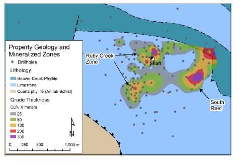
| Page 7-8 |
| January 31, 2013 |
|
UPPER KOBUK MINERAL PROJECTS |
| BORNITE DEPOSIT – SOUTH REEF AND RUBY CREEK ZONES | |
| ALASKA, USA | |
| NI 43-101 TECHNICAL REPORT | |
FIGURE 7-4: N-S CROSS
SECTION AT 589250E SHOWING THE
GEOMETRY OF MINERALIZATION AND
GEOLOGY IN THE RUBY CREEK
ZONE
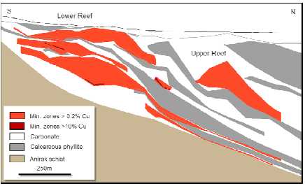
| 7.4.1 |
Mineralization |
Copper mineralization at Bornite is comprised of chalcopyrite, bornite, and chalcocite distributed in stacked, roughly stratiform zones exploiting favourable stratigraphy within the dolomitized limestone package. Mineralization occurs, in order of increasing grade, as disseminations, irregular and discontinuous stringer-style veining, breccia matrix replacement, and stratiform massive sulphides. Figure 7-5 shows typical high-grade mineralization composed of strong chalcocite, bornite, and chalcopyrite mineralization.
| Page 7-9 |
| January 31, 2013 |
|
UPPER KOBUK MINERAL PROJECTS |
| BORNITE DEPOSIT – SOUTH REEF AND RUBY CREEK ZONES | |
| ALASKA, USA | |
| NI 43-101 TECHNICAL REPORT | |
FIGURE 7-5: TYPICAL HIGH-GRADE CHALCOCITE, BORNITE, AND CHALCOPYRITE MINERALIZATION

The distribution of copper mineral species is zoned around the bottom-centre of each zone, with bornite-chalcocite-chalcopyrite at the core and progressing outward to chalcopyrite-pyrite. Additional volumetrically minor copper species include carrollite, digenite, tennantite-tetrahedrite, and covellite (Bernstein and Cox, 1986). Stringer pyrite and locally significant sphalerite occur above and around the copper zones, while locally massive pyrite and sparse pyrrhotite occur in association with siderite alteration below copper mineralization in the Lower Reef. Figures 7-6 and 7-7 show northeast-southwest and northwest-southeast-trending sections across the South Reef, showing geology, mineralization, and alteration. Figure 10-5 shows the South Reef section locations. Figure 7-8 shows a northwest-trending section through the Ruby Creek zone, with the Lower Reef again showing geology, mineralization, and alteration.
| Page 7-10 |
| January 31, 2013 |
|
UPPER KOBUK MINERAL PROJECTS |
| BORNITE DEPOSIT – SOUTH REEF AND RUBY CREEK ZONES | |
| ALASKA, USA | |
| NI 43-101 TECHNICAL REPORT | |
FIGURE 7-6: NE-SW LONG
SECTION THROUGH THE SOUTH REEF
ILLUSTRATING GEOLOGY AND
ZONATION
OF ORE MINERALS AND SECONDARY
DOLOSTONE
![]()
| Page 7-11 |
| January 31, 2013 |
|
UPPER KOBUK MINERAL PROJECTS |
| BORNITE DEPOSIT – SOUTH REEF AND RUBY CREEK ZONES | |
| ALASKA, USA | |
| NI 43-101 TECHNICAL REPORT | |
FIGURE 7-7: NW-SE CROSS
SECTION THROUGH THE SOUTH REEF
ILLUSTRATING GEOLOGY AND
ZONATION
OF ORE MINERALS AND SECONDARY
DOLOSTONE
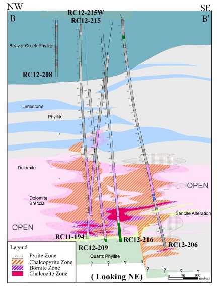
| Page 7-12 |
| January 31, 2013 |
|
UPPER KOBUK MINERAL PROJECTS |
| BORNITE DEPOSIT – SOUTH REEF AND RUBY CREEK ZONES | |
| ALASKA, USA | |
| NI 43-101 TECHNICAL REPORT | |
FIGURE 7-8: NW-SE CROSS
SECTION THROUGH THE LOWER REEF
ILLUSTRATING GEOLOGY AND
ZONATION
OF ORE MINERALS AND SECONDARY
DOLOSTONE

In addition to the copper mineralization, significant cobalt mineralization (for example, drill hole RC11-0187 with 34.7 m at 0.10% Co in the South Reef, and drill hole RC11-0184 with 5.5 m at 0.44% Co in the Upper Reef) is found accompanying bornite-chalcocite mineralization. Cobalt occurs with high-grade copper as both carrollite (Co2CuS4) and as cobaltiferous rims on recrystallized pyrite grains (Bernstein and Cox, 1986).
Appreciable silver values (for example, drill hole RC11-0184 with 5.5 m at 30.9 g/t Ag) are also found with bornite-rich mineralization in the South Reef and Ruby Creek zones.
| 7.4.2 |
Alteration |
Limestone in much of the resource area is altered to secondary hydrothermal dolostone. Dolomitic alteration follows and also cuts stratigraphy, generally following the distribution of copper sulphide mineralization which is almost entirely hosted within it. Iron content of secondary dolomite is distinctively zoned, with high-iron dolostone centred on the axis of higher-grade chalcopyrite-bornite-chalcocite mineralization (Figure 7-8). At its most intense, dolomitic alteration can also include secondary siderite (± pyrrhotite), which is mapped as an elongated northeast-trending body beneath copper mineralization in the Lower Reef (Hitzman, 1986).
| Page 7-13 |
| January 31, 2013 |
|
UPPER KOBUK MINERAL PROJECTS |
| BORNITE DEPOSIT – SOUTH REEF AND RUBY CREEK ZONES | |
| ALASKA, USA | |
| NI 43-101 TECHNICAL REPORT | |
Secondary dolomite alteration is mainly restricted to the limestone units, although calcareous phyllites are locally affected. More widespread are the green-gray ‘bleached’ calc-phyllites (so-called ‘talc’ phyllites), which are tentatively interpreted as an alteration product of the dark gray argillaceous calc-phyllite units. Bleached calc-phyllite occurs as discontinuous, semi-stratiform to discordant bodies within the larger interpreted phyllite beds; distribution is ambiguous with respect to dolomitization and copper mineralization. Initial analysis of ICP multi-element data indicates that bleached phyllites have experienced neither magnesium nor sodium metasomatism.
| 7.5 |
Prospects/Exploration Targets |
The Bornite carbonate sequence host to the mineralization at Bornite is exposed over approximately 10 miles (16 km) along the north slope of the Cosmos Hills and to a lesser extent on the southern margin of the Cosmos Hills arch (Figure 7-1). Numerous areas of hydrothermal dolomitization and copper mineralization occur across the entire width of outcropping carbonates and are the focus of ongoing regional exploration by NovaCopper. Most notable of the known prospects are the Pardner Hill and Aurora Mountain areas, where outcropping mineralization was discovered and drill-tested during the Kennecott era.
The Pardner Hill prospect is located 3 miles (5 km) west of Bornite (Figure 7-1) and consists of a 1.8 mile (3 km) copper (± zinc) soil and rock geochemical anomaly in rubble cropping ferroan dolostone. Kennecott drilled 16 holes in the area and defined a stratiform copper mineralized zone approximately 490 ft by 1,310 ft (150 m by 400 m) and varying from 16 ft to 115 ft (5 m to 35 m) thick at the southern end of the geochemical anomaly. Mineralization remains open down-dip and to the south.
Dolomitization and anomalous copper and zinc geochemistry also characterize the Aurora Mountain prospect located 3.6 miles (6 km) west of Bornite (Figure 7-1). Anomalies are distributed along a 1.2 mile (2 km) mineralized horizon about a third of which has been tested by four Kennecott-era drill holes.
| Page 7-14 |
| January 31, 2013 |
|
UPPER KOBUK MINERAL PROJECTS |
| BORNITE DEPOSIT – SOUTH REEF AND RUBY CREEK ZONES | |
| ALASKA, USA | |
| NI 43-101 TECHNICAL REPORT | |
| 8 |
DEPOSIT TYPES |
As outlined in the previous section, copper-cobalt-silver-zinc-germanium mineralization at Bornite occurs as disseminated, vein, and massive sulphides forming stacked, semi-stratiform bodies closely associated with secondary hydrothermal dolomitization. The crosscutting nature of the mineralization along with the presence of early pyrite and sphalerite in sedimentary breccia clasts point to a clearly epigenetic origin, but temporally very close to the formation of the enclosing stratigraphy. Recent Re-Os dating supports this interpretation.
Data are limited regarding sources of the copper-rich fluids which formed the Bornite deposit, but it suggests that ore fluids may have formed from the interaction of saline basinal fluids with mafic volcanic rocks mapped within the section.
Given these constraints, Bornite has characteristics similar to a series of districts and deposits including: the Mt Isa and McArthur River districts in Australia, the Tynagh deposit in Ireland, the Kipushi deposit in the Congo, and the Tsumeb deposit in Namibia. All of these deposits show: syngenetic to early epigenetic characteristics; emplacement in carbonate stratigraphy; and, early pyrite-dolomite alteration followed by sulphide mineralization.
All of these analogous deposits occur in intra-continental to continental margin settings undergoing extensional tectonics and bimodal volcanism similar to Bornite. Basin-margin faults seem to play an important role in localizing mineralization (Hitzman, 1983) even though the postulated basin margin structures at Bornite have not been directly identified.
| Page 8-1 |
| January 31, 2013 |
|
UPPER KOBUK MINERAL PROJECTS |
| BORNITE DEPOSIT – SOUTH REEF AND RUBY CREEK ZONES | |
| ALASKA, USA | |
| NI 43-101 TECHNICAL REPORT | |
| 9 |
EXPLORATION |
Kennecott's 1957-1998 exploration in and around the Bornite deposit is summarized in Section 6.1 of this Technical Report. In addition to the extensive drilling completed during Kennecott's more than 40 year tenure in the district, Kennecott completed widespread surface geochemical sampling, regional and property scale mapping, and numerous geophysical surveys that employed a wide variety of techniques. The majority of the data has been acquired by NovaCopper and forms the basis for renewed exploration that targets the Bornite-style mineralization in the Bornite carbonate sequence.
In 2005, NovaGold actively pursued an agreement with NANA Regional Corporation to explore the Bornite district. This resulted in an initial airborne geophysical survey in 2006. Negotiations on the consolidation and exploration of the entire Ambler district continued for the next several years culminating in the NANA Agreement in October, 2011.
With the agreement approaching completion, NovaGold initiated work in 2010 to characterize the exploration potential and depositional controls by re-logging and re-analyzing select drill holes with a Niton portable XRF to determine geochemical variability. In 2011, NovaGold began an initial drill program to verify the historical database and exploration potential and conducted additional geophysical surveys to provide better targeting tools for continued exploration in the district. In 2012, NovaCopper expanded the IP geophysical coverage completing a major district-wide survey that targeted the prospective Bornite Carbonate sequence.
| 9.1 |
2006 NovaGold Exploration |
In 2006, NovaGold contracted Fugro Airborne Surveys (Fugro) to complete a detailed helicopter DIGHEM magnetic, electromagnetic and radiometric survey of the Cosmos Hills. The survey covered a rectangular block approximately 11 miles by 30 miles (18 km by 49 km which totalled 2,852 line kilometres). The survey was flown at 1,000 ft (300 m) line spacing with a line direction of N20E. The DIGHEM helicopter survey system produced detailed profile data of magnetics, EM responses and radiometrics (total count, uranium, thorium, and potassium) and was processed into maps of magnetics, discrete EM anomalies, EM apparent resistivities, and radiometric responses. A report and Fugro-processed maps and grids are available (Fugro, 2007). Figure 9-1 shows total field magnetics from the survey.
| Page 9-1 |
| January 31, 2013 |
|
UPPER KOBUK MINERAL PROJECTS |
| BORNITE DEPOSIT – SOUTH REEF AND RUBY CREEK ZONES | |
| ALASKA, USA | |
| NI 43-101 TECHNICAL REPORT | |
FIGURE 9-1: 2006 DIGHEM TOTAL FIELD MAGNETICS
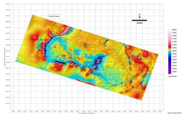
| 9.2 |
2010 NovaGold Exploration |
In 2010, in anticipation of completing the NANA Agreement, NANA Regional Corporation granted NovaGold permission to begin low level exploration at Bornite; this consisted of re-logging and re-analyzing select drill holes using a Niton portable XRF. A profile containing Kennecott surface diamond drill holes: RC-27, -29, -32, -35, -53, -0, -62, and -102, and underground drill hole RU-16 were re-logged and re-analyzed in the Bornite camp in July and August 2010. The results are shown in Figure 9-2. In general, the re-logging compared moderately well with the 1996 Kennecott interpretation. General relationships apparent in Figure 9-2 include: a thick area of dolomitization centred approximately at drill hole RC-60 corresponding with mineralization, and surrounding and overlying the No. 1 Ore Body; iron-rich dolomite, forming an inner alteration zone; and, a strong stratigraphic control with mineralization occurring in dolomitized limestones immediately overlying a graphitic phyllite.
| Page 9-2 |
| January 31, 2013 |
|
UPPER KOBUK MINERAL PROJECTS |
| BORNITE DEPOSIT – SOUTH REEF AND RUBY CREEK ZONES | |
| ALASKA, USA | |
| NI 43-101 TECHNICAL REPORT | |
FIGURE 9-2: 2010 NW-SE REINTERPRETED PROFILE ACROSS THE BORNITE DEPOSIT
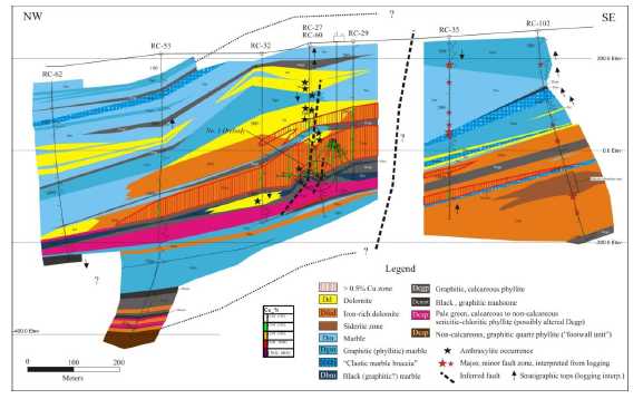
One notable distinction from the Kennecott re-logging interpretation was the recognition of a significant stratigraphic and structural discontinuity between the southeastern and northwestern parts of the section. A sharp, apparent truncation or offset of mineralization, dolomitization, and stratigraphic units across this boundary is apparent in the re-logging effort. Interpretation of the discontinuity remains unclear at this time, but could represent either a post-mineral offset or a potential syn-mineral feeder structure associated with mineralization in the No. 1 Ore Body.
The apparent structural complexity in the area surrounding the No. 1 Ore Body, including the inferred structural discontinuity east of the No. 1 Ore Body, contrast with the stratigraphic and structural continuity evident in weakly- to unmineralized strata in the northwestern part of the section (Figure 9-2). The structural heterogeneity in the area of the No. 1 Ore Body suggests that inferred structures in this area may have been active during hydrothermal activity and may have in part controlled mineral deposition (Montgomery, 2010).
In addition to the 2010 re-logging effort, NovaGold contracted a consulting geophysicist, Lou O'Connor, to compile a unified airborne magnetic map for the Ambler district from Kennecott, Alaska DNR, and NovaGold airborne geophysical surveys; the compilation is shown in Figure 9-3.
| Page 9-3 |
| January 31, 2013 |
|
UPPER KOBUK MINERAL PROJECTS |
| BORNITE DEPOSIT – SOUTH REEF AND RUBY CREEK ZONES | |
| ALASKA, USA | |
| NI 43-101 TECHNICAL REPORT | |
FIGURE 9-3: DISTRICT AIRBORNE MAGNETICS COMPILED FROM KENNECOTT, AK DNR AND NOVAGOLD SURVEYS

| 9.3 |
2011 NovaGold Exploration |
In 2011, in light of the relatively poor understanding of appropriate ground geophysical techniques for the prospect and the extensive cover over perspective stratigraphic terrain dipping shallowly to the north in the Ambler lowlands, NovaGold contracted Zonge International Inc. (Zonge) to conduct both dipole-dipole complex resistivity induced polarization (CRIP) and natural source audio-magnetotelluric (NSAMT) surveys over the prospect to develop better geophysical tools for further exploration.
NSAMT data were acquired along two lines totalling 5.15 line-km, with one line oriented generally north-south through the centre of the survey area and one being the southernmost east-west line in the survey area. CRIP data were acquired on five lines: four east-west lines and one north-south line, for a total coverage of 14.1 line-km and 79 collected CRIP stations. The initial objective of the survey was to investigate geological structures and the distribution of sulphides possibly associated with copper mineralization.
Results from the paired surveys show that wide-spaced dipole-dipole resistivity is the most effective technique to directly target the mineralization package. Broad low resistivity anomalies reflecting the pyrite haloes and mineralization appear to define the limits of the fluid package. Well-defined and often very strong chargeability anomalies are also present, but appear in part to be masked by phyllitic units which also have strong chargeability signatures. The NSAMT show similar resistivity features as the IP, but are less well resolved.
| Page 9-4 |
| January 31, 2013 |
|
UPPER KOBUK MINERAL PROJECTS |
| BORNITE DEPOSIT – SOUTH REEF AND RUBY CREEK ZONES | |
| ALASKA, USA | |
| NI 43-101 TECHNICAL REPORT | |
| 9.4 |
2012 NovaCopper Exploration |
In light of the success of the 2011 geophysical program, NovaCopper contracted Zonge to conduct a major district-wide dipole/dipole IP survey, a down-hole IP radial array survey in the South Reef, and an extensive physical property characterization study of the various lithologies to better interpret the existing historical geophysical data.
Zonge completed 29.8 line miles (48 line km) of 200 m dipole/dipole IP during 2012, infilling and expanding on the 2011 survey, and stretching across the most prospective part of the outcropping permissive Bornite Carbonate sequence. Figures 9-4 and 9-5 show isometric views of the combined 2011 and 2012 surveys for resistivity and IP, respectively. Although the data are only now being interpreted, the results show a well-defined low resistivity area associated with mineralization and variable IP signatures attributed both to mineralization and the overlying Beaver Creek phyllite. Numerous target areas occur in the immediate Bornite area with lesser targets occurring in the Aurora Mountain and Pardner Hill areas and in the far east of the survey area. During the 2012 drill program at South Reef, a single drill hole was targeted on a low resistivity area approximately 500 m to 600 m southeast of the South Reef trend. Although the drill hole intersected some dolomite alteration in the appropriate stratigraphy, no significant sulphides were encountered.
| Page 9-5 |
| January 31, 2013 |
|
UPPER KOBUK MINERAL PROJECTS |
| BORNITE DEPOSIT – SOUTH REEF AND RUBY CREEK ZONES | |
| ALASKA, USA | |
| NI 43-101 TECHNICAL REPORT | |
FIGURE 9-4: ISOMETRIC VIEW OF 2011 AND 2012 RESISTIVITY PROFILES
![]()
FIGURE 9-5: ISOMETRIC VIEW OF 2011 AND 2012 CHARGEABILITY PROFILES
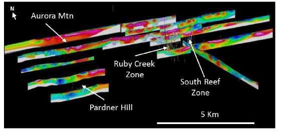
In addition to the extensive ground IP survey, Zonge also completed 5.6 line miles (9 km) of down-hole radial IP using an electrode placed in drill hole RCDH12-0197 to further delineate the trend and potential in and around the South Reef. Results for the resistivity and chargeability are shown in Figures 9-6 and 9-7. The heavy black line represents the limit of copper grade x thickness >50% m. Due to the nature of the geophysical methodology, and because the electrode was emplaced directly within the conductive mineralized body, the apparent resistivity is shown as inverse values. Mineralization shows as broad conductive areas in both the Ruby Creek and the South Reef zones. The resistivity survey indicates there is potential to expand the South Reef zone to the northeast and to the south. The chargeability data show the overlying highly chargeable Beaver Creek phyllite and some irregular IP features surrounding the low resistivity zone related to mineralization within the Bornite Carbonate. These features could represent marginal high pyrite zones.
| Page 9-6 |
| January 31, 2013 |
|
UPPER KOBUK MINERAL PROJECTS |
| BORNITE DEPOSIT – SOUTH REEF AND RUBY CREEK ZONES | |
| ALASKA, USA | |
| NI 43-101 TECHNICAL REPORT | |
FIGURE 9-6: PLAN MAP OF RESISTIVITY – DOWN-HOLE RADIAL IP SURVEY

| Page 9-7 |
| January 31, 2013 |
|
UPPER KOBUK MINERAL PROJECTS |
| BORNITE DEPOSIT – SOUTH REEF AND RUBY CREEK ZONES | |
| ALASKA, USA | |
| NI 43-101 TECHNICAL REPORT | |
FIGURE 9-7: PLAN MAP OF RESISTIVITY – DOWN-HOLE RADIAL IP SURVEY

In addition to the ground geophysical surveys, extensive physical property data including resistivity, chargeability, specific gravity, and magnetic susceptibility have been captured and are currently being used in modelling of the existing ground IP and gravity surveys, and the airborne EM and magnetic surveys. In general, some broad comments can be made concerning geophysical domains in and around mineralization at Bornite. Mineralization is characterized by low resistivity < 20 ohms, ambiguous but elevated, often irregular chargeability highs (> 35 milliradians) marginal to the mineralization, and 3-5 milligal gravity anomalies. Mineralization appears to lie along the flanks of 20-150 nT long wave magnetic anomalies which might reflect deep-seated mafic greenstones deeper in the stratigraphy.
| 9.5 |
Exploration Potential |
The Ambler District, which is part of the UKMP, was the focus of major exploration activities in the 1960s through to the early 1980s after which the district received little attention. Exploration beginning after NovaGold’s entry into the district in 2004, using current exploration techniques and ore genesis models, suggests the Bornite carbonate sequence is a substantial exploration target.
Outcropping exposures of the ore-hosting carbonate stratigraphy along with large areas of precursor dolomite alteration occur over approximately 11 miles (18 km) of strike along the northern flank of the Cosmos Hills. Historical exploration drilling has focused solely on outcropping mineralization and subsurface extensions at Bornite and the Aurora Mountain and Pardner Hill areas. Much of the carbonate belt has yet to be evaluated.
| Page 9-8 |
| January 31, 2013 |
|
UPPER KOBUK MINERAL PROJECTS |
| BORNITE DEPOSIT – SOUTH REEF AND RUBY CREEK ZONES | |
| ALASKA, USA | |
| NI 43-101 TECHNICAL REPORT | |
Recent USGS dating of mineralization in the Ambler District has shown that the VMS belt that hosts the Arctic deposit and the Bornite carbonate-hosted mineralization are contemporaneous and only slightly post-date enclosing stratigraphy. This early and extensive syngenetic/early epigenetic signature, along with the overall fluid chemistry of the system investigated by early workers, such as Hitzman (1983 and 1986), point to large saline basin-generated fluid transport as the mechanism controlling the metallogeny of the Ambler District. Importantly, similar metallogenies related to saline, basin-generated fluids and their associated deposits form some of the largest copper districts in the world.
Understanding the potential scale of mineralization in the Ambler District has led NovaCopper to adopt geophysical and geochemical zonation as their main tools of exploration.
Airborne geophysics completed in 2006, discussed in Section 9.1, along with district-wide compilations of select third party data, discussed Section 9.2 and shown in Figure 9-3, show that the Bornite carbonate section and bounding stratigraphy simply dip to the north under the Ambler lowlands toward the Ambler Schist Belt. This opens up important potential to explore for high-grade, Bornite-style, carbonate-hosted deposits at depth using new deeper-penetrating geophysical techniques.
The geophysical surveys have delineated significant north-northeast to northeast oriented structures which appear in part to control local basin morphology and mineralization (Figure 9-1). Better understanding of basin development and its structural framework is critical to the exploration of Bornite-style systems.
In 1999, Kennecott completed an initial gravity survey of the lowlands showing significant gravimetric anomalies which may indicate structural dislocations and potential alteration and mineralization (Figure 6-1). In 2011, NovaCopper investigated both deep IP and NSAMT geophysical techniques.
Results from the 2011 program led to a 2012 district-wide, 200 m dipole-dipole, deep-penetrating IP survey; the results are summarized in Section 9.4. That survey along with extensive 2012 physical property data capture for all lithologies and existing ground IP, gravity and airborne EM and magnetic surveys is currently being used to develop a comprehensive geophysical model of the district to support future exploration targeting.
| Page 9-9 |
| January 31, 2013 |
|
UPPER KOBUK MINERAL PROJECTS |
| BORNITE DEPOSIT – SOUTH REEF AND RUBY CREEK ZONES | |
| ALASKA, USA | |
| NI 43-101 TECHNICAL REPORT | |
In addition to the geophysical techniques used in exploration, recent ICP trace element analysis suggests a series of effective zonation vectors, including very distinct high iron (as pyrite) and zinc (as sphalerite) zones which overly and cap areas of significant copper mineralization.
| Page 9-10 |
| January 31, 2013 |
|
UPPER KOBUK MINERAL PROJECTS |
| BORNITE DEPOSIT – SOUTH REEF AND RUBY CREEK ZONES | |
| ALASKA, USA | |
| NI 43-101 TECHNICAL REPORT | |
| 10 |
DRILLING |
The Bornite Project database contains data from a total of 247 drill holes, totaling 76,593 metres. This includes drilling on the Bornite deposits plus exploratory drilling on other targets on the Ambler property. A total of 217 drill holes, totaling 70,003 metres, are considered to be targeted in proximity to the Bornite deposits. These holes have been completed during 20 different annual campaigns dating from 1957 through 2012. Three underground programs totalling 51 drill holes and targeting the No.1 Ore Body at Ruby Creek were completed between 1966 and 1968.
All of the drill campaigns, with the exception of the 2011 NovaGold campaign and the 2012 NovaCopper campaign, 14 and 22 drill holes, respectively, were completed by Kennecott. Sprague and Henwood, a Pennsylvania-based drilling company, completed all of the Kennecott drilling, with the exception of the 1997 program (three drill holes) completed by Tonto Drilling Services, Inc. (a NANA Dynatech company). The 2011/2012 NovaGold/NovaCopper programs used Boart Longyear Company.
The Kennecott drilling was conducted using imperial measurement units. Imperial units have been converted to metric equivalents in the NovaCopper database. NovaCopper worked exclusively in metric units.
In the initial years of drilling at Bornite, Kennecott relied on AX core (1.1875 in diameter), but, as deeper holes pursued mineralization down dip to north became the norm, use of BX core (1.625 in diameter) was gradually implemented; small diameter AX rods would twist under the high torque and deviate in undetermined directions. From 1966 to1967, drilling activity at Bornite moved underground and EX diameter core (0.845 in diameter) was implemented to define the No.1 Ore Body. Drilling activity moved back to the surface in 1968, and, from 1968 to 1972, BX core was most commonly drilled. In later years, core size increased to NX (2.125 in diameter) and finally, in 2011, core size increased to NQ (1.874 in or 47.6 mm diameter) and HQ (2.5 in or 63.5 mm diameter). Progressively larger diameter drill rods have been continually used over the years in an attempt to minimize drill hole deviations.
| 10.1 |
Drill Campaigns |
Figure 10-1 shows 1957-1963 surface drill campaigns and collar locations completed by Kennecott.
| Page 10-1 |
| January 31, 2013 |
|
UPPER KOBUK MINERAL PROJECTS |
| BORNITE DEPOSIT – SOUTH REEF AND RUBY CREEK ZONES | |
| ALASKA, USA | |
| NI 43-101 TECHNICAL REPORT | |
FIGURE 10-1: 1957 TO 1963 DRILL CAMPAIGNS AND COLLAR LOCATIONS
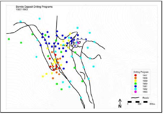
In October 1965, Kennecott began a shaft to further investigate the No.1 Ore Body. In 1966, the shaft reached the 975 ft (297 m) level. At this level, a 300 ft (91 m) crosscut was driven due north to the No.1 Ore Body. The shaft was continued to 1,075 ft (328 m) deep to prepare a sump and loading pocket. On October 27, 1966, a small blast to excavate a bay at the bottom of the shaft opened a watercourse. The in-flood of water quickly exceeded the pump capacity and within 12 hours the 1,075 ft (328 m) shaft was flooded to within 42 ft (13 m) from the surface (Hawke Engineering 1966, Flooding on October 27, 1966 exploration shaft at Bornite Alaska: Ruby Creek development Kennecott Copper Corporation).
Prior to the shaft flooding, six diamond drill holes were completed from the 700 level shaft station and 22 drill holes from the 975 shaft station and crosscut. In 1967, the shaft bottom was partially sealed and then pumped out, and an additional 24 holes were drilled from the 975 level and the 700 level shaft stations. Figures 10-2 and 10-3 show underground diamond drilling from the 700 and 975 levels.
| Page 10-2 |
| January 31, 2013 |
|
UPPER KOBUK MINERAL PROJECTS |
| BORNITE DEPOSIT – SOUTH REEF AND RUBY CREEK ZONES | |
| ALASKA, USA | |
| NI 43-101 TECHNICAL REPORT | |
FIGURE 10-2: DIAMOND DRILLING FROM THE 700 LEVEL OF THE NO. 1 SHAFT

FIGURE 10-3: DIAMOND DRILLING FROM THE 975 LEVEL OF THE NO. 1 SHAFT
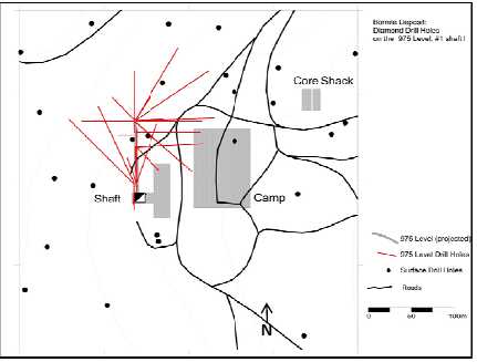
| Page 10-3 |
| January 31, 2013 |
|
UPPER KOBUK MINERAL PROJECTS |
| BORNITE DEPOSIT – SOUTH REEF AND RUBY CREEK ZONES | |
| ALASKA, USA | |
| NI 43-101 TECHNICAL REPORT | |
Between 1968 and 1983, Kennecott completed very limited drilling at Bornite that focused largely on extensions to the No.1 Ore Body or targeted the South Reef area. Kennecott subsequently sold the property to NANA and no exploration drilling occurred between 1983 and 1997. In 1997, Kennecott leased the Bornite property from NANA and drilled five exploration holes.
In 2011, NovaGold negotiated a preliminary agreement with NANA that allowed NovaGold to conduct an exploration program on the Bornite property in anticipation of the broader scoped NANA Agreement which was close to completion. That same year NovaGold drilled 14 holes totalling 19,091 ft (5,819 m). Figure 10-4 shows collar locations for holes drilled between 1968 and 2011.
FIGURE 10-4: DRILL HOLE COLLAR LOCATION 1968 - 2011
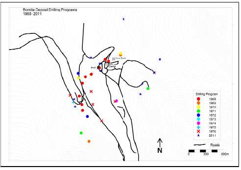
The 2011 NovaGold drill program had three objectives: obtain new geologic and assay data to verify and validate the previous work done by Kennecott; test extensions of the known deposit; and, drill new areas for potential mineralization and geologic information near the deposit.
In 2012, NovaCopper, based on the results of its 2011 exploration drilling at South Reef, began aggressively delineating mineralization in that zone. A total of 21 drill holes and one nearby exploration drill hole were completed totalling 15,457 m (Figure 10-5). The drilling was patterned on hexagonal closely-packed drill spacing with individual holes spaced approximately 100 m apart on the apices of equilateral triangles. Results of that drilling program are shown in Table 10.1.
| Page 10-4 |
| January 31, 2013 |
|
UPPER KOBUK MINERAL PROJECTS |
| BORNITE DEPOSIT – SOUTH REEF AND RUBY CREEK ZONES | |
| ALASKA, USA | |
| NI 43-101 TECHNICAL REPORT | |
FIGURE 10-5: SOUTH REEF DRILL HOLE COLLAR LOCATIONS 2012

| Page 10-5 |
| January 31, 2013 |
|
UPPER KOBUK MINERAL PROJECTS |
| BORNITE DEPOSIT – SOUTH REEF AND RUBY CREEK ZONES | |
| ALASKA, USA | |
| NI 43-101 TECHNICAL REPORT | |
TABLE 10.1: SUMMARY OF 2012 SOUTH REEF DRILLING
| Thickness | Cu | Co | Au | Ag | |||
| From | To | (metres) | % | % | g/t | g/t | |
| DDH RC12-0195 | 581.7 | 593.5 | 11.7 | 2.74 | - | - | - |
| 1 interval | 11.7 | 2.74 | - | - | - | ||
| DDH RC12-196 | 460.2 | 486.8 | 26.6 | 2.64 | - | - | - |
| 489.8 | 504.1 | 14.3 | 1.47 | - | - | - | |
| 2 intervals | 40.8 | 2.23 | - | - | - | ||
| DDH RC12-197 | 397.4 | 435.4 | 37.9 | 3.12 | - | - | - |
| 442.4 | 462.6 | 20.2 | 1.83 | - | - | - | |
| 2 intervals | 58.1 | 2.67 | - | - | - | ||
| DDH RC12-0198 | 544.6 | 562.3 | 17.7 | 1.47 | - | - | - |
| 631.7 | 652.9 | 21.2 | 3.86 | 0.23 | 0.22 | - | |
| 2 intervals | 38.9 | 2.77 | - | - | - | ||
| DDH RC12-0199 | 580.0 | 586.5 | 6.5 | 4.30 | - | - | - |
| 1 interval | 6.5 | 4.30 | - | - | - | ||
| DDH RC12-0200 | 488.0 | 502.6 | 14.7 | 4.73 | - | - | - |
| 536.3 | 538.6 | 2.3 | 9.47 | - | 0.39 | 5.6 | |
| 566.0 | 578.2 | 12.2 | 3.42 | - | - | - | |
| 584.3 | 605.7 | 21.4 | 1.86 | - | - | - | |
| 4 intervals | 50.5 | 3.41 | - | - | - | ||
| DDH RC12-0201 | 560.1 | 596.5 | 36.4 | 5.27 | - | - | - |
| 1 intervals | 36.4 | 5.27 | - | - | - | ||
| DDH RC12-202 | 533.9 | 561.8 | 27.9 | 4.13 | - | 0.27 | 6.1 |
| 578.5 | 591.3 | 12.8 | 2.41 | - | - | - | |
| 2 intervals | 40.6 | 3.59 | - | - | - |
| Page 10-6 |
| January 31, 2013 |
|
UPPER KOBUK MINERAL PROJECTS |
| BORNITE DEPOSIT – SOUTH REEF AND RUBY CREEK ZONES | |
| ALASKA, USA | |
| NI 43-101 TECHNICAL REPORT | |
TABLE 10.1: SUMMARY OF 2012 SOUTH REEF DRILLING - CONT'D
| Thickness | Cu | Co | Au | Ag | |||
| From | To | (metres) | % | % | g/t | g/t | |
| DDH RC12-0203 | 392.1 | 420.0 | 27.9 | 1.67 | - | - | - |
| 444.4 | 463.6 | 19.2 | 1.59 | - | - | - | |
| 629.2 | 651.7 | 22.5 | 2.78 | - | - | 14.9 | |
| 3 intervals | 69.6 | 2.01 | - | - | - | ||
| DDH RC12-0204 | no significant intervals | ||||||
| - | - | - | |||||
| DDH RC12-0205 | 621.2 | 635.5 | 14.3 | 2.67 | - | - | - |
| 638.6 | 647.2 | 8.6 | 2.48 | - | - | - | |
| 2 intervals | 22.9 | 2.60 | - | - | - | ||
| DDH RC12-0206 | 516.6 | 524.6 | 8.0 | 4.44 | - | - | - |
| 657.1 | 661.2 | 4.2 | 5.50 | - | 0.15 | - | |
| 2 intervals | 12.2 | 4.80 | - | - | - | ||
| DDH RC12-0207 | 540.0 | 551.7 | 11.7 | 5.02 | - | - | - |
| 1 interval | 11.7 | 5.02 | - | - | - | ||
| DDH RC12-0208 | hole lost before target depth | ||||||
| - | - | - | |||||
| DDH RC12-0209 | 667.5 | 682.4 | 14.9 | 1.68 | - | - | - |
| 686.9 | 715.7 | 28.8 | 3.79 | - | 0.13 | - | |
| 723.0 | 738.2 | 15.2 | 5.94 | - | - | - | |
| including* | 729.1 | 731.7 | 2.6 | 22.26 | - | 0.30 | - |
| 752.5 | 764.8 | 12.3 | 2.93 | - | - | - | |
| 4 intervals | 71.2 | 3.66 | - | - | - | ||
| no significant intervals - exploration drill | |||||||
| DDH RC12-0210 | hole - 500m east | - | - | - | |||
| - | - | - | |||||
| Page 10-7 |
| January 31, 2013 |
|
UPPER KOBUK MINERAL PROJECTS |
| BORNITE DEPOSIT – SOUTH REEF AND RUBY CREEK ZONES | |
| ALASKA, USA | |
| NI 43-101 TECHNICAL REPORT | |
TABLE 10.1: SUMMARY OF 2012 SOUTH REEF DRILLING - CONT'D
| Thickness | Cu | Co | Au | Ag | |||
| From | To | (metres) | % | % | g/t | g/t | |
| DDH RC12-0211 | 619.8 | 628.0 | 8.2 | 7.91 | - | 0.15 | - |
| 637.2 | 642.5 | 5.3 | 4.08 | - | - | - | |
| 651.7 | 669.2 | 17.5 | 5.10 | 0.07 | 0.47 | 11.02 | |
| including* | 656.3 | 658.5 | 2.2 | 16.80 | 0.45 | 3.18 | 58.70 |
| 673.7 | 686.9 | 13.2 | 6.96 | 0.06 | 0.23 | - | |
| including* | 676.2 | 679.4 | 3.2 | 14.28 | 0.08 | 0.42 | - |
| 4 intervals | 44.2 | 6.06 | - | - | - | ||
| DDH RC12-0212 | 551.2 | 559.9 | 8.7 | 4.95 | - | - | - |
| 570.4 | 578.5 | 8.2 | 3.64 | - | 0.15 | - | |
| 2 intervals | 16.8 | 4.31 | - | - | - | ||
| DDH RC12-0213 | 606.7 | 610.3 | 3.6 | 3.97 | - | - | 6.5 |
| 1 interval | 3.6 | 3.97 | - | - | - | ||
| DDH RC12-0214 | 480.3 | 493.8 | 13.5 | 2.27 | - | - | - |
| 498.1 | 533.3 | 35.2 | 2.50 | - | - | - | |
| 540.5 | 565.6 | 25.1 | 3.18 | - | - | - | |
| 3 intervals | 73.8 | 2.69 | - | - | - | ||
| DDH RC12-0215* | 634.5 | 652.1 | 17.6 | 2.05 | - | - | - |
| 1 interval | 17.6 | 2.05 | - | - | - | ||
| DDH RC12-0215W** | 628.7 | 644.5 | 15.9 | 2.54 | - | - | - |
| 1 interval | 15.9 | 2.54 | - | - | - | ||
| DDH RC12-0216 | 599.6 | 609.8 | 10.1 | 2.80 | - | - | - |
| 627.7 | 639.2 | 11.4 | 4.71 | - | - | 8.4 | |
| 671.0 | 726.7 | 55.7 | 4.45 | 0.05 | 0.27 | - | |
| 3 intervals | 77.2 | 4.27 | - | - | - |
| Page 10-8 |
| January 31, 2013 |
|
UPPER KOBUK MINERAL PROJECTS |
| BORNITE DEPOSIT – SOUTH REEF AND RUBY CREEK ZONES | |
| ALASKA, USA | |
| NI 43-101 TECHNICAL REPORT | |
| 10.2 |
Drill Contractors |
All of the drill campaigns, with the exception of the 2011/2102 NovaGold/NovaCopper campaigns, were completed by Kennecott. Sprague and Henwood, a Pennsylvania-based drilling company, completed all of the Kennecott drilling, with the exception of the 1997 program (three drill holes) completed by Tonto Drilling Services, Inc. (a NANA Dynatech company). The 2011 and 2012 NovaGold program used Boart Longyear Canada Inc. Table 10.2 summarizes the drill campaigns, the core sizes used, and the drilling contractors.
TABLE 10.2: SUMMARY OF THE BORNITE DRILLING PROGRAMS
Year |
Surface
DH's |
UG DH's |
Metres |
Core Size |
Drill Contractor |
| 1957 | 8 | 1,749 | AX | Sprague and Henwood | |
| 1958 | 10 | 2,150 | AX | Sprague and Henwood | |
| 1959 | 14 | 4,932 | AX & BX | Sprague and Henwood | |
| 1960 | 13 | 4,083 | AX & BX | Sprague and Henwood | |
| 1961 | 33 | 13,590 | AX, BX, & NX | Sprague and Henwood | |
| 1962 | 24 | 8,450 | AX, BX, & NX | Sprague and Henwood | |
| 1963 | 1 | 396 | BX | Sprague and Henwood | |
| 1966 | 0 | 26 | 1,384 | EX & AX | Sprague and Henwood |
| 1967 | 0 | 21 | 1,862 | EX & AX | Sprague and Henwood |
| 1968 | 8 | 4 | 3,210 | BX & AX | Sprague and Henwood |
| 1969 | 2 | 781 | BX | Sprague and Henwood | |
| 1970 | 2 | 733 | BX | Sprague and Henwood | |
| 1971 | 2 | 829 | BX? | Sprague and Henwood | |
| 1972 | 2 | 712 | BX? | Sprague and Henwood | |
| 1974 | 1 | 456 | NX & BX | Sprague and Henwood | |
| 1975 | 1 | 316 | NX & BX | Sprague and Henwood | |
| 1976 | 6 | 2,168 | NXWL & BXWL | Sprague and Henwood | |
| 1997 | 3 | 928 | NX & HQ | Tonto | |
| 2011 | 14 | 5,819 | NQ & HQ | Boart Longyear | |
| 2012 | 22 | 15,457 | NQ & HQ | Boart Longyear | |
| Total | 166 | 51 | 70,003 |
| Page 10-9 |
| January 31, 2013 |
|
UPPER KOBUK MINERAL PROJECTS |
| BORNITE DEPOSIT – SOUTH REEF AND RUBY CREEK ZONES | |
| ALASKA, USA | |
| NI 43-101 TECHNICAL REPORT | |
| 10.3 |
Core Logging |
All of the drill data collected during the Kennecott drilling programs (1958-1997) was logged on paper drill logs; copies are stored in the Kennecott exploration office in Salt Lake City, Utah. Electronic scanned copies of the paper logs, in PDF format, are held by NovaCopper.
In 1995, Kennecott converted the drilling assay data, the geologic core logs, and the down-hole collar survey data into an electronic format. In 2009, NovaGold geologists verified the geologic data comparing the original paper logs against the Kennecott database and merged all the data into a Microsoft™ SQL database.
The 2011 and 2012 NovaGold/NovaCopper diamond drilling programs used a commercial, computer-based core logging system for data capture: GeoSpark Logger© developed by GeoSpark Consulting Inc. During each drill program, all logging data was captured on individual lap tops in a Microsoft™ SQL database and then validated and merged into the main database. In 2012, the system was modified to allow each laptop to sync daily to the master Data Logger database residing on the Bornite Camp server. The server was periodically backed up and the database was sent to Vancouver, British Columbia for backup storage. The camp server is stored in the Fairbanks field office at the end of each field season. Hardcopies of the 2011 and 2012 drill core logs are stored in the Fairbanks office. Scanned copies of the Kennecott-era drill logs are also stored in the Fairbanks field office.
| 10.4 |
Core Recovery |
Table 10.3 shows the core recovery data compared to various rock types with available recovery data for all campaigns through to 2011. In general, core recovery averaged > 90% with only slightly poorer recoveries in phyllitic rocks. Mineralized dolomitic units had excellent recoveries in excess of 93%. South Reef drilling, in 2012, showed core recovery rates of 88.8% overall and 88.3% in the mineralized dolomite and massive sulphide intervals.
| Page 10-10 |
| January 31, 2013 |
|
UPPER KOBUK MINERAL PROJECTS |
| BORNITE DEPOSIT – SOUTH REEF AND RUBY CREEK ZONES | |
| ALASKA, USA | |
| NI 43-101 TECHNICAL REPORT | |
TABLE 10.3: CORE RECOVERY VERSUS LITHOLOGY
Lithology |
% Recovery |
Standard Deviation |
Number of Samples |
Length (m) |
| Argillaceous Limestone Clastic Breccia | 91.9 | 51.0 | 619 | 1,189 |
| Argillaceous Carbonaceous Phyllite | 89.3 | 32.6 | 2,169 | 3,865 |
| Dolostone Clastic Breccia | 95.2 | 22.1 | 1,552 | 3,442 |
| Limestone Clastic Breccia | 91.8 | 34.5 | 2,437 | 5,399 |
| Dolostone & Thinly Bedded Dolostone | 93.4 | 46.6 | 1,601 | 3,100 |
| Fault Zone | 66.2 | 32.3 | 62 | 71 |
| Limestone & Thinly Bedded Limestone | 91.2 | 27.7 | 1,245 | 2,980 |
| Massive Sulphides | 101.2 | 9.4 | 16 | 43 |
| Undefined | 91.9 | 20.7 | 298 | 743 |
| Quartz Phyllite | 84.3 | 25.7 | 130 | 266 |
| Talc Phyllite & Talc Lime Phyllite | 83.6 | 40.5 | 544 | 939 |
| Totals | 91.3 | 35.3 | 10,674 | 22,038 |
| 10.5 |
Collar Surveys |
Collar locations for the 14 holes drilled in 2011 were surveyed by NovaGold using a differential GPS relative to ‘AAA-1' benchmark established by Karl Spohn, PLS, WH Pacific, Inc. (WHPacific), in 2010. An Ashtech ProMark2 GPS instrument was used for this survey.
Also during the 2011 field season, 63 of the 131 historic surface holes were resurveyed in UTM NAD83 zone 4N datum. Results of this resurvey were compared to the original Kennecott collar survey data. Errors were found to cluster tightly around zero, with a mean difference of 1.61 m Easting and -0.80 m Northing. Absolute total horizontal error ranged from 0.39 m to a maximum 24.27 m, with a median absolute error of 1.22 m. The 24.7 m error was an obvious outlier surveying error. Based on these results, the original Kennecott collar coordinates were accepted for the 68 non-resurveyed surface holes without application of a horizontal correction. Given that the underground drill collars are not accessible, the original coordinates for the 51 underground holes were also accepted and included in the 2012 Ruby Creek resource estimate. The 2011 Ashtech collar re-survey replaced the collar coordinates for the 63 re-surveyed surface holes.
The 2011 collar re-survey campaign revealed a semi-systematic elevation error of about +10 m in most of the historic collars. Elevation differences in the existing database were found to range from -2.17 m to 10.91 m, with a median error of 9.61 m. While these errors show some patterns in space and time, it was not feasible to determine a unifying correction factor for elevation. To find a reasonable solution for surface holes that could not be re-surveyed, NovaCopper assigned these holes elevations from NovaGold’s 2010 PhotoSat 1 m resolution digital terrain model (DTM).
| Page 10-11 |
| January 31, 2013 |
|
UPPER KOBUK MINERAL PROJECTS |
| BORNITE DEPOSIT – SOUTH REEF AND RUBY CREEK ZONES | |
| ALASKA, USA | |
| NI 43-101 TECHNICAL REPORT | |
Also, the benchmark for the shaft and the elevation control for the underground drill hole collar surveys could not be located during the re-survey exercise to provide a reasonable elevation check between the underground survey and the surface elevations of the DTM. Therefore, the underground holes were given a blanket +10 m correction consistent with the error observed in the re-surveyed surface holes around the underground workings. As a quantitative check, it was confirmed that the lithological contacts constructed from the adjusted drill holes aligned well with the lithological contacts encountered in the 2011 drilling. The collar elevations for the 63 resurveyed holes were assigned elevations from the 2011 re-survey.
In summary, the collar coordinates for 63 historical surface holes, including fourteen 2011 drill holes used in the 2012 Ruby Creek resource estimate, were surveyed or re-surveyed in 2011 using UTM NAD 83 zone 4 coordinates. For the remaining 119 surface and underground drill holes, the original collar horizontal coordinates were directly converted to UTM NAD83 zone 4 coordinates. The comparisons of new and historic collar elevations indicated an inconsistent, but approximate, +10 m variance. For the surface drill holes that were not re-surveyed, the collar elevations were assigned the surface elevation from the 2010 PhotoSat 1 m resolution DTM. For underground drill hole collars, a +10 m adjustment was assigned to the original collar survey data.
In 2012, collar locations for 17 of the 22 holes drilled in the South Reef were surveyed by WHPacific professional land surveyors using a differential GPS relative to benchmark ‘AAA-1’ established by WHPacific in 2010. The remaining five holes were surveyed by NovaCopper using an Ashtech ProMark2 GPS instrument relative to the same ‘AAA-1’ benchmark. The three holes drilled in 2011, which are part of the South Reef resource, were also surveyed by NovaGold using the same GPS and base station as mentioned above. All 2011 and 2012 holes were surveyed in the UTM zone 4N datum coordinate system and the NAD83 datum.
Five of the six historical drill holes, that are part of the South Reef resource, were located and surveyed. The original horizontal Kennecott collar coordinates for drill hole RC-163 (the one drill hole not found) was accepted and included. The collar elevation for drill hole RC-163 was assigned the surface elevation from the 2010 PhotoSat 1-m resolution DTM.
| Page 10-12 |
| January 31, 2013 |
|
UPPER KOBUK MINERAL PROJECTS |
| BORNITE DEPOSIT – SOUTH REEF AND RUBY CREEK ZONES | |
| ALASKA, USA | |
| NI 43-101 TECHNICAL REPORT | |
| 10.6 |
Down-Hole Surveys |
Of the 217 diamond drill holes completed at Bornite, approximately 48%, or 104 drill holes, have down-hole surveys. However, evaluated from a drill-length perspective, 68%, or 47,689 m of the total 70,003 m drilled are located by down-hole surveys.
Since 1961, Sperry-Sun single shot surveys were conducted on drill holes with significant mineralization, and holes with marginal mineralization were often not surveyed. In 1961, Kennecott attempted to survey previous holes drilled in 1959 and 1960. Of the 51 underground holes, only 11 are surveyed. From 1968 through 1997, down-hole surveys were sporadic. The first six holes of the 1968 campaign, and all holes drilled in 1971 and 1997 were not surveyed.
Four Kennecott drill holes at South Reef that were never surveyed have been assigned projected deviations based on nearby (surveyed) holes. (Down-hole surveys assigned to holes RC-96, RC-95, RC-99 and RC-163). The resulting locations of mineralized intervals in these drill holes mesh better with the overall geologic interpretation of the deposit.
NovaGold (in 2011) and NovaCopper (in 2012) completed down-hole surveys of all of their drill holes using a Reflex Easy-Shot instrument. The 2011 holes were surveyed every 100 ft (30 m), and the 2012 holes were surveyed every 150 ft (45 m). Three drill holes (RC-95, RC-96 and RC-163) within the South Reef resource area have not been surveyed and their down-hole deviations have been estimated by averaging the deviations of nearby holes of the same drill diameter. Figure 10-6 shows surface drill holes with down-hole survey data.
| Page 10-13 |
| January 31, 2013 |
|
UPPER KOBUK MINERAL PROJECTS |
| BORNITE DEPOSIT – SOUTH REEF AND RUBY CREEK ZONES | |
| ALASKA, USA | |
| NI 43-101 TECHNICAL REPORT | |
FIGURE 10-6: SURFACE DRILLING WITH DOWN-HOLE SURVEYS
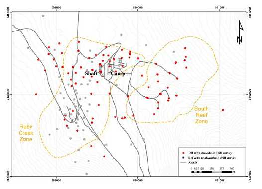
| 10.7 |
Miscellaneous Drilling Information |
No geotechnical, hydrological, or metallurgical drilling has been completed by NovaCopper on the Project.
| Page 10-14 |
| January 31, 2013 |
|
UPPER KOBUK MINERAL PROJECTS |
| BORNITE DEPOSIT – SOUTH REEF AND RUBY CREEK ZONES | |
| ALASKA, USA | |
| NI 43-101 TECHNICAL REPORT | |
| 11 |
SAMPLE PREPARATION, ANALYSES, AND SECURITY |
| 11.1 |
Sampling Methods |
During the 2011 and 2012 drill programs at Bornite, NovaGold/NovaCopper used the same strict sampling protocols that were developed for the nearby Arctic deposit in 2004 and documented in NovaGold's procedure manuals for all subsequent years.
The following discussion outlines the standard protocols used by NovaGold/NovaCopper in 2011/2012: The entire length of each drill hole was sampled, excluding recovered overburden. Core-logging geologists marked each sample interval on the core and labelled the core boxes using a china marker. A tear-off sample tag was secured to the core box at the beginning of each sample interval which typically ranged from 1 m to 3 m) long, although samples as short as 0.35 m and as long as 6.09 m were taken in a few instances. Sample intervals within mineralized zones were limited to a maximum length of 2 m. Sample breaks were placed at lithological contacts, changes in alteration, and areas of sulphide mineralization. There are no known drilling or recovery issue that could materially impact accuracy.
The core was digitally photographed and cut in half using diamond core saws after logging at the on-site core facility. If the drill core intersected mineralization at a shallow angle, the core-logging geologist would place a guide line on the core to ensure a representative sample. Oriented core was cut along the orientation mark to preserve the orientation of the core unless otherwise marked by the core geologist. One-half of the cut core was returned to the box for storage on-site, and the other half was bagged and labelled for sample processing and analysis. Figure 11-1 shows one of the four drill core cutting bays.
FIGURE 11-1: DRILL CORE CUTTING BAY

| Page 11-1 |
| January 31, 2013 |
|
UPPER KOBUK MINERAL PROJECTS |
| BORNITE DEPOSIT – SOUTH REEF AND RUBY CREEK ZONES | |
| ALASKA, USA | |
| NI 43-101 TECHNICAL REPORT | |
In 2012, six drill holes (RC-92, RC-93, RC-95, RC-96, RC-163, and RC-174) that were drilled in and around the South Reef zone during Kennecott’s historical tenure on the property were re-assayed using historical core archived on the property. Due to the small diameter of some holes, partial sampling, and the mixture of half and full core, NovaCopper opted to consume the entire remaining core from these holes during re-assay. All of the holes were re-logged using the same criteria and procedures as the 2011/2012 drilling and digitally photographed. All of the drill holes for the South Reef zone have the same logging and assay procedures. No historical Kennecott data, other than the historical down-hole surveys or lack thereof, are included in the South Reef resource estimate.
Sampling of drill core by Kennecott during their tenure on the property focused primarily on moderately to strongly mineralized zones. Numerous intervals of weak to moderate mineralization remain unsampled in the historic drill core and in the 1997 campaign where Kennecott did not intersect significant mineralization and no analyzes were done for resource evaluation. Intervals of moderate to strong sulphide mineralization were selected for sampling, and analyzes were conducted by the Union Assay Office Inc. of Salt Lake City, Utah prior to the establishment of the on-site lab in 1962. Historical Kennecott assays and data from the Ruby Creek zone used in the Ruby Creek resource estimate are discussed further and verified in Section 12.
| 11.2 |
Metallurgical Sampling |
In 2011, NovaGold did not sample any drill core for metallurgical test work. Kennecott composited 32 crushed (coarse reject) AX core samples from five surface holes for metallurgic float tests done in 1961 (Zimmerley, 1961). The core samples were from the high-grade No.1 Ore Body and averaged 13.9% Cu. Additional details can be found in Section 6.1.
In late 2012, NovaCopper requested an initial metallurgical evaluation on a series of varying grade composites developed from the South Reef zone. Four composites reflecting low-grade (0.5 -1.0% Cu), medium-grade (1.0 -2.0% Cu), high-grade (2.0 -10.0% Cu), and very high-grade (>10.0% Cu) copper have been submitted to ALS Chemex Labs Ltd. (ALS Chemex) in Vancouver, British Columbia and G&T Metallurgical Services Ltd. (G&T Metallurgical) in Kelowna, British Columbia for analysis. Results are expected in the second quarter of 2013.
| 11.3 |
Density Determinations |
All density measurements for the 2011 and 2012 programs were performed on-site by NovaGold/NovaCopper. The specific gravity of selected samples was calculated by weighing the entire assay interval dry and then submersed in water. In 2011, the dry and wet weights were entered into a Microsoft™ Excel spreadsheet that calculated the specific gravity. The data were uploaded into the DataShed database. In 2012, the dry and wet weights were recorded on pre-printed paper forms and later entered into the DataShed database. All sample intervals that were estimated as having ≥ 1% chalcopyrite (CuFeS2) or its equivalent copper content (0.3% Cu) were measured along with one interval in every five boxes (10 m to 15 m) of unmineralized core.
| Page 11-2 |
| January 31, 2013 |
|
UPPER KOBUK MINERAL PROJECTS |
| BORNITE DEPOSIT – SOUTH REEF AND RUBY CREEK ZONES | |
| ALASKA, USA | |
| NI 43-101 TECHNICAL REPORT | |
No known density measurements were performed by Kennecott.
| 11.4 |
Analytical and Test Laboratories |
ALS Minerals was used for all primary analyses submitted by NovaGold in 2011 and NovaCopper in 2012. The core samples were sent from site to the ALS prep facility in Fairbanks, Alaska. The samples were processed and reduced to pulp at this facility and sent to ALS Minerals Vancouver, British Columbia lab for analysis. ALS Minerals is located at 2103 Dollarton Highway, North Vancouver, BC V7H 0A7. ALS Minerals complies with and is accredited for the requirements of International Standards Organization ISO 9001:2008 and ISO/IEC 17025:2005 General Requirements for the Competence of Testing and Calibration Laboratories.
The ALS Minerals Vancouver lab forwarded the selected check sample pulps to Acme Analytical Laboratories (Acme Labs), Vancouver, British Columbia. Acme Labs is located at 1020 Cordova St. East, Vancouver, BA V6A 4A3. Acme Labs is compliant with the International Standards Organization (ISO) 9001 Model for Quality Assurance and ISO/IEC 17025 General Requirements for the Competence of Testing and Calibration Laboratories.
Historical core was analyzed by Union Assay Lab in Salt Lake City, Utah and by the on-site Kennecott lab established in 1964.
| 11.5 |
Sample Preparation and Analysis |
The 2011 and 2012 halved core samples were crushed to 70% passing 2 mm and a nominal 250 g split was pulverized to 85% passing 75 microns at the ALS Minerals Fairbanks facility. The resulting pulp was sent to ALS Minerals Vancouver lab for analysis. Gold content was determined by fire assay fusion with an atomic absorption (AA) finish from a nominal 30 g split. Initial results for all other elements (48) were determined via four acid digestion and both ICP-MS and ICP-AES analysis on a nominal 25 g split. Samples with over-limit values for copper and zinc (> 10,000 ppm) were re-run using a four-acid digestion, which was diluted for an ICP-AES or AA finish. Samples greater than 40% Cu were re-run using a volumetric titration finish after a four acid-digestion.
| Page 11-3 |
| January 31, 2013 |
|
UPPER KOBUK MINERAL PROJECTS |
| BORNITE DEPOSIT – SOUTH REEF AND RUBY CREEK ZONES | |
| ALASKA, USA | |
| NI 43-101 TECHNICAL REPORT | |
| 11.6 |
Quality Assurance and Quality Control |
NovaCopper continued its standard QA/QC program, first initiated by NovaGold in 2004.Three QA/QC samples selected by the logging geologist were inserted into every 20-sample batch. QA/QC samples included one duplicate, one blank, and one standard reference material (SRM). Duplicate samples were prepared at the prep facility by taking a second split from the entire prepped sample. In 2011, a commercial landscape marble was used as the blank material for every drill hole, except one. Barren marble core, from a previous abandoned drill hole, was used as the blank material for one 2011 drill hole and all 2012 drill holes.
In 2011, four SRMs were used and, in 2012, five SRMs were used. In 2011, a very low grade SRM was inserted in batches that consisted of unmineralized core. The other three SRMs, ranging in accepted copper values of 0.193% to 2.37%, were inserted to match the estimated copper content of the core. One SRM was sourced from CDN Resource Laboratories Ltd. labs in Langley, British Columbia and the other three were from Ore Research and Exploration in North Victoria, Australia.
In 2012, a very low grade SRM was inserted in batches that consisted of unmineralized core. The other four SRMs, ranging in accepted copper values of 0.193% to 10.403%, were inserted to match the estimated copper content of the core. Two SRMs were sourced from CDN labs; one was sourced from Ore Research & Exploration Pty Ltd., North Victoria, Australia; and, the remaining two were sourced from Geostats Pty Ltd. of Western Australia.
In 2011, NovaCopper completed an in-house analysis and review of QA/QC results and, in 2012, NovaCopper contracted GeoSpark Consulting Inc. to review and manage QA/QC performance on the project. Assay performances for 2011 and 2012 blank and SRM samples were found to be within acceptable limits.
Examples of SRM performance for 2011 and 2012 are shown in Figures 11-2 and 11-3, respectively.
| Page 11-4 |
| January 31, 2013 |
|
UPPER KOBUK MINERAL PROJECTS |
| BORNITE DEPOSIT – SOUTH REEF AND RUBY CREEK ZONES | |
| ALASKA, USA | |
| NI 43-101 TECHNICAL REPORT | |
FIGURE 11-2: STANDARD OREAS 111 CONTROL CHART – 2011 PERFORMANCE
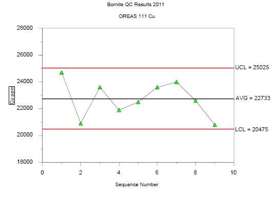
FIGURE 11-3: STANDARD ME-14 CONTROL CHART – 2012 PERFORMANCE

| Page 11-5 |
| January 31, 2013 |
|
UPPER KOBUK MINERAL PROJECTS |
| BORNITE DEPOSIT – SOUTH REEF AND RUBY CREEK ZONES | |
| ALASKA, USA | |
| NI 43-101 TECHNICAL REPORT | |
As an added check to the labs, check samples for an alternative second lab were selected by the project geologist once all the primary assay results were received in both 2011 and 2012. The check samples consisted of 5% of the total samples from only the mineralized lithologies (carbonates and semi- to massive-sulphides) and were randomly selected. These samples were forwarded to Acme Labs, also located in Vancouver, British Columbia. Figures 11-4 and 11-5 show 5% Acme Labs check assays plotted against original ALS Chemex assays in 2011 and 2012. No bias is apparent.
FIGURE 11-4: ACME LABS VERSUS ALS CHEMEX – 2011 5% DUPLICATE CHECK

| Page 11-6 |
| January 31, 2013 |
|
UPPER KOBUK MINERAL PROJECTS |
| BORNITE DEPOSIT – SOUTH REEF AND RUBY CREEK ZONES | |
| ALASKA, USA | |
| NI 43-101 TECHNICAL REPORT | |
FIGURE 11-5: ACME LABS VERSUS ALS CHEMEX – 2012 5% DUPLICATE CHECK

| 11.7 |
Databases |
All 2011 and 2012 core logging data, including sample intervals and descriptions, were directly entered into a Microsoft™ Access-based application called Data Logger created by, and customized for, the project by GeoSpark Consulting Inc., Nanaimo, British Columbia. In 2011, data were imported on a weekly basis into the DataShed database located on the server at NovaGold's Vancouver, British Columbia office. In 2012, the system was modified to allow each laptop to sync daily to the master Data Logger database residing on the Bornite camp server. The server was periodically backed up periodically and the database was sent to Vancouver. Assay data were imported directly into the DataShed database from .csv files either downloaded or e-mailed from ALS Labs.
| 11.8 |
Sample Security |
Each cut sample interval was placed in a 6-mil polyethylene bag with the sample number written in black permanent marker on an attached Tyvek sample card stub detailing the sample number and bar code. Two to four samples were placed into a larger rice bag labelled with the ALS Minerals address, project (hole) number, bag number, and enclosed sample numbers. The rice bag was secured with a pre-numbered, plastic security tie and a twist wire tie. The security tie number and total weight was recorded. The rice bags were transported from the Bornite Camp to Fairbanks on a chartered flight with a commercial carrier. A contracted expeditor met the chartered flight at the airport to pick-up up the sample shipment and delivered it directly to the ALS Minerals prep facility located at 1060 Bush Street, Fairbanks.
| Page 11-7 |
| January 31, 2013 |
|
UPPER KOBUK MINERAL PROJECTS |
| BORNITE DEPOSIT – SOUTH REEF AND RUBY CREEK ZONES | |
| ALASKA, USA | |
| NI 43-101 TECHNICAL REPORT | |
Generally, five to seven batches, weighing between 1,000 and 2,400 pounds, were shipped each week. ALS processed each batch as they arrived at the prep facility; however, ALS held the pulps until the entire drill hole was prepared so that the drill hole was analyzed as a single project or job in Vancouver. ALS Minerals did not notify NovaGold/NovaCopper of any missing or broken security ties or any other issues related to the sample shipments or packaging.
BDRC considers the Bornite Project drill core sampling protocols, security, and analytical procedures to have met accepted industry standard procedures. Core recovery is good and there is no evidence that diamond drill recovery could materially impact the assay sampling results.
| Page 11-8 |
| January 31, 2013 |
|
UPPER KOBUK MINERAL PROJECTS |
| BORNITE DEPOSIT – SOUTH REEF AND RUBY CREEK ZONES | |
| ALASKA, USA | |
| NI 43-101 TECHNICAL REPORT | |
| 12 |
DATA VERIFICATION |
A number of previous data verification programs have been undertaken on the Bornite Project data by NovaGold, NovaCopper, and independent consultants. In 2012-2013, Bruce Davis, FAusIMM, completed two site visits and two independent verifications of the Bornite Project database in support of the Ruby Creek zone (2012) and South Reef zone (2013) mineral resource updates.
| 12.1 |
Verifications by NovaGold/NovaCopper |
In 2007, legacy data (1957-1997) were compiled from both digital and paper logs supplied by Kennecott into a central Microsoft™ Access database.
In 2008, the Microsoft™ Access database was imported into DataShed, a SQL-based data management software program created by Maxwell GeoServices Pty Ltd.
In 2011, NovaGold began using a customizable Data Logger created by GeoSpark Consulting Inc. at the Bornite Project. This Microsoft™ Access-based software was used to capture all drilling and surface data. A data entry technician entered the geological information, collar, and down-hole survey data at the Bornite camp. Data were then exported by geologists on-site to Microsoft™ Excel or Microsoft™ Access format and posted on a secure FTP site for the Database Manager in Vancouver. These exports were then imported directly into the DataShed database in Vancouver. Assay data were imported directly from electronic files provided by the laboratories. At the end of the field season, all geological information, collar, and down-hole survey information was visually verified by NovaGold geologists by comparing original files against an export of the database.
Also in 2011, NovaGold began to capture specific gravity and geotechnical data, such as Rock Quality Designation (RQD) and core recovery. Specific gravity data were recorded and then entered into Microsoft™ Excel spreadsheets. Geotechnical data were recorded and then entered into the Data Logger software. Data were exported to the Database Manager in Vancouver to be included in the DataShed database. A 100% visual check of the specific gravity and geotechnical logs were completed at the end of the 2011 field season and all errors and omissions were corrected in the DataShed database.
Also in 2011, NovaGold re-surveyed all accessible historic drill hole collars; this is further discussed in Section 10.5.
| Page 12-1 |
| January 31, 2013 |
|
UPPER KOBUK MINERAL PROJECTS |
| BORNITE DEPOSIT – SOUTH REEF AND RUBY CREEK ZONES | |
| ALASKA, USA | |
| NI 43-101 TECHNICAL REPORT | |
In 2012, NovaCopper contracted GeoSpark to convert the Bornite Project DataShed database into a SQL-based data management software program. GeoSpark was contracted to update the Data Logger software, manage the database, and provide ongoing QA/QC support. In 2012, NovaCopper geologists logged directly into the Data Logger software and data were uploaded to the master database on a daily basis. Assay data were imported directly from electronic files provided by the laboratories. At the end of the field season, QA/QC checks were conducted on the database and, at that time, some minor errors and omissions were corrected.
| 12.2 |
Verifications by Independent Consultants |
| 12.2.1 |
Jack Cote (2011) |
In September 2011, to ensure the integrity of the Bornite database, an independent data management consultant, Jack Cote, was contracted by NovaGold to carry out a 100% audit of the historic (1957-1997) collar, down-hole survey, sample interval, and assay data. There are no previously known comprehensive audits of the historic Bornite dataset.
A preliminary Bornite database had been constructed in 2007-2008 by NovaGold, as outlined in the Section 12.1; this was used as a starting point for Cote's audit. After initial review, it was decided that the entire legacy (1957-1997) dataset be rebuilt using the original data sources now in the NovaGold's possession. Collar, down-hole survey, sample interval, and assay data were re-entered into the database using double entry procedures to ensure validity. All remaining data, including lithology, alteration, and mineralization were not re-entered or validated at the time.
All discrepancies and errors, and subsequent actions and adjustments to the database for the collar, down-hole survey, sample interval, and assay data are outlined here; these were implemented by NovaGold’s Database Manager according to Jack Cote’s recommendations.
| Page 12-2 |
| January 31, 2013 |
|
UPPER KOBUK MINERAL PROJECTS |
| BORNITE DEPOSIT – SOUTH REEF AND RUBY CREEK ZONES | |
| ALASKA, USA | |
| NI 43-101 TECHNICAL REPORT | |
Collar Data
-
213 collars were initially in the Bornite database in DataShed.
-
76 of the 213 collars could not be verified with any original data source.
-
9 significant conversion errors were identified within the RC* holes.
-
All of the RU* and RUS* underground holes had significant conversion errors.
-
All of the verified collar data were merged into the Bornite database in DataShed.
Down-hole Survey Data
-
664 down-hole survey records were initially in the Bornite database in DataShed.
-
160 of the 664 could not be verified with any original data source.
-
20 of the 504 records that could be verified had small (<2 degree) errors, mostly due to incorrect calculations using magnetic north.
-
All of the verified down-hole survey data were merged into the Bornite database in DataShed.
Sample Data
-
After backup, all sample data were deleted from the Bornite database in DataShed.
-
Cote located 7,385 samples from original data sources (documents, drill logs, etc.).
-
563 “NoSample(s)” were created to account for unsampled intervals.
-
819 quality control (check) samples were delineated.
-
39 overall errors (meterage and sample numbers) were identified.
-
28 of the 39 errors were accepted and changes were made to the database.
-
All of the verified sample data were merged into the Bornite database in DataShed.
| Page 12-3 |
| January 31, 2013 |
|
UPPER KOBUK MINERAL PROJECTS |
| BORNITE DEPOSIT – SOUTH REEF AND RUBY CREEK ZONES | |
| ALASKA, USA | |
| NI 43-101 TECHNICAL REPORT | |
Assay Data
-
After backup, all assay data were deleted from the Bornite database in DataShed.
-
Cote made a first pass of the assay data and entered all copper values from assay certificates.
-
After the first pass, 1,385 copper values in the database were without a verifiable data source.
-
After the first pass, 1,766 cobalt values and 743 base metal values (gold, silver, lead, and zinc) were without a verifiable data source. NovaCopper geologist, Bonnie Broman, made a second pass and entered the remaining copper assay data from other sources (principally drill logs) and then she made a third pass and verified the remainder of the cobalt and base metal data.
-
All of the verified assay data was merged into the Bornite database in DataShed.
Overall, very few errors (<3%) were found between the 2007-2008 NovaGold compiled historic database and Cote's re-entered database files. Collar errors were mostly transformation problems between coordinate systems, and errors in the down-hole survey data were small azimuth and dip calculation problems. Minor errors in the sample data were generally meterage typos. All errors have been addressed and corrected.
| 12.2.2 |
GeoSpark Consulting Inc. (2012) |
The 2012 exploration program used the GeoSpark Logger database system to enter drill hole data directly into a relational database interface to control data quality and data integrity as it was entered. The data were synchronized to a master GeoSpark Logger database. The master database was populated with assay results directly from source files.
The analytical results were reviewed by GeoSpark for inferred precision and accuracy as the results were reported. Any issues with the quality of the results were addressed as the results were reported. Rerun of samples in the vicinity of any failing standard or blank materials took place and the rerun results were assigned precedence in the database.
| Page 12-4 |
| January 31, 2013 |
|
UPPER KOBUK MINERAL PROJECTS |
| BORNITE DEPOSIT – SOUTH REEF AND RUBY CREEK ZONES | |
| ALASKA, USA | |
| NI 43-101 TECHNICAL REPORT | |
At the completion of the 2012 exploration program, GeoSpark completed further database quality checks. It is GeoSpark’s opinion that NovaCopper has taken the necessary steps to ensure a good quality database for its 2012 exploration program at the Upper Kobuk Mineral Projects, which includes the Bornite Project.
GeoSpark said the following:
Check samples were selected as a representative set of samples using a five percent random selection within percentile ranges on significant drill hole intervals defined by the project geologists. The check sample review found that there is no significant bias in the results reported by ALS compared to results reported by Acme Labs.
The re- assay results reported by ALS Chemex on original historic analytical results within the Upper Kobuk Mineral Project databases were compared in order to provide insight into the original result quality. 274 silver pairs and 224 copper pairs were compared to provide insight for any bias in the results. The review ultimately found bias in the original results to be insignificant.
| 12.2.3 |
BD Resource Consulting, Inc. & SIM Geological Inc. (2011, 2012) |
Bruce Davis, FAusIMM, BD Resource Consulting, Inc., examined a series of randomly selected drill core intervals from the Ruby Creek and South Reef zones during his site visits in July, 2011 and September, 2012. In all cases, the type and content of observed copper-bearing minerals supported the copper grades found in the Bornite Project database.
To support the South Reef mineral resource estimate, Robert Sim, P.Geo., SIM Geological Inc., selected the following five NovaCopper-era drill holes for manual validation:
- RC12-0211
- RC12-0214
- RC12-0196
- RC12-0202
- RC11-0192
The collar, survey, and assay information for these holes in the electronic database was checked against original data sources. No significant errors or differences were found in the collar or survey data. The original assay certificate for drill hole RC11-0192 was not immediately available; therefore, drill hole RC11-0192 could not be verified. Since no errors were found in assays from the other four holes, and because those four holes represented over 15% of the total data, no effort was made to retrieve the missing certificate.
| Page 12-5 |
| January 31, 2013 |
|
UPPER KOBUK MINERAL PROJECTS |
| BORNITE DEPOSIT – SOUTH REEF AND RUBY CREEK ZONES | |
| ALASKA, USA | |
| NI 43-101 TECHNICAL REPORT | |
The South Reef database is derived from 100% NovaCopper-era drill holes and six Kennecott drill holes which were re-sampled by NovaCopper in 2012. These data were collected and assayed using industry standard practices and assaying was controlled by the QA/QC program outlined in Section 11.
| 12.3 |
Conclusions |
Given the assay check results, the review of the drilling and core sampling, and the comparison of certificates to the electronic database, the sample assay data are within acceptable limits of precision and accuracy to generate a mineral resource estimate.
BDRC believes the database construction procedures outlined in Section 12 meet industry standards, and the current data are sufficient for the estimation of Indicated and Inferred mineral resources.
| Page 12-6 |
| January 31, 2013 |
|
UPPER KOBUK MINERAL PROJECTS |
| BORNITE DEPOSIT – SOUTH REEF AND RUBY CREEK ZONES | |
| ALASKA, USA | |
| NI 43-101 TECHNICAL REPORT | |
| 13 |
MINERAL PROCESSING AND METALLURGICAL TESTING |
| 13.1 |
Historical Metallurgical Testwork |
Very limited metallurgical testwork has been completed at Bornite. In 1961, Kennecott completed some preliminary metallurgical test work from five drill holes (RC-34, RC-54, RC-60, RC-61, and RC-65) comprising 32 coarse reject samples piercing the No.1 Ore Body (Bear Creek Mining Co. Memo Lutz, 1961).
All sample intervals, in total weighing approximately 150 lbs (68 kg) were composited using weighted compositing methodology. Prior to compositing, each sample was crushed and screened to pass a 10-mesh screen. Most samples were in two parts: one contained in plastic (assumed unoxidized) and one contained part in canvas (oxidized).
The composite sample assayed 13.9% Cu; 97.64% of the copper was recovered in a concentrate assaying 43.90% copper after a locked-cycle laboratory test. Fine grinding to 5% passing +200-mesh was required to obtain the liberation of copper minerals from pyrite necessary for such high recovery. Composite ore mineralogy from the test work is shown in Table 6.1 where deportment studies show the high-grade mineralization of the No.1 Ore Body dominated by bornite with subordinate chalcocite and chalcopyrite.
It is not known whether the testing conducted by Kennecott used samples representative of the various types of mineralization, or whether any deleterious elements were encountered during the tests.
NovaGold and NovaCopper have done no metallurgical testwork on the Bornite deposit.
| Page 13-1 |
| January 31, 2013 |
|
UPPER KOBUK MINERAL PROJECTS |
| BORNITE DEPOSIT – SOUTH REEF AND RUBY CREEK ZONES | |
| ALASKA, USA | |
| NI 43-101 TECHNICAL REPORT | |
| 14 |
MINERAL RESOURCE ESTIMATES |
| 14.1 |
Introduction |
This section describes the generation of mineral resource estimates for the Ruby Creek and South Reef zones of the Bornite Project. NovaCopper filed a previous National Instrument 43-101 (NI 43-101) Technical Report, dated August 28, 2012 and authored by Bruce M. Davis, FAusIMM of BD Resource Consulting, Inc. (BDRC), that contains a mineral resource estimate for the Ruby Creek zone. There has been no new information related to the Ruby Creek zone and, as a result, the 2012 Technical Report (Davis, 2012) remains valid. Information from the August 2012 Technical Report regarding the Ruby Creek mineral resource estimate has been summarized and included in this report.
The South Reef zone mineral resource estimate has been prepared by Bruce M. Davis FAusIMM, BDRC and Robert Sim P.Geo., SIM Geological Inc. (SGI) both “independent Qualified Persons” as defined in NI 43-101. The effective date of the South Reef zone mineral resource statement is January 31, 2013.
This section describes the resource estimation methodology and summarizes the key assumptions considered by the Qualified Persons. In the opinion of the Qualified Persons, the resource evaluation reported herein is a sound representation of the copper mineral resources found on the Bornite Project at the current level of sampling. The mineral resources have been estimated in conformity with generally accepted CIM Estimation of Mineral Resources and Mineral Reserves Best Practices Guidelines and are reported in accordance with the Canadian Securities Administrators’ National Instrument 43-101 (NI 43-101). Mineral resources are not mineral reserves and do not have demonstrated economic viability. There is no certainty that all or any part of the mineral resource will be converted into mineral reserve.
The databases used to estimate the Bornite Project mineral resources were audited by the Qualified Persons. The Qualified Persons are of the opinion that the current drilling information is sufficiently reliable to interpret with confidence the boundaries for copper mineralization and that the assay data are sufficiently reliable to support mineral resource estimation.
Vulcan version 8.1.4 was used to review, verify, and design the Ruby Creek resource estimation domains, prepare assay data for geostatistical analysis, construct the block model, estimate metal grades, and tabulate mineral resources. The non-commercial software, including Geostatistical Library (GSLib) family of software, and Sage 2001© were used for geostatistical analysis and variography.
| Page 14-1 |
| January 31, 2013 |
|
UPPER KOBUK MINERAL PROJECTS |
| BORNITE DEPOSIT – SOUTH REEF AND RUBY CREEK ZONES | |
| ALASKA, USA | |
| NI 43-101 TECHNICAL REPORT | |
MineSight® v7.50 was used to review, verify, and design the South Reef resource estimation domains, prepare assay data for geostatistical analysis, construct the block model, determine a “dynamic anisotropy” search orientation, estimate metal grades, and tabulate mineral resources. The non-commercial software, including Geostatistical Library (GSLib) family of software was used for geostatistical analysis.
| 14.2 |
Resource Estimation Procedures |
The resource evaluation methodology involved the following procedures:
- Site investigation;
- Database compilation and verification;
- Interpretation of geologic model;
- Exploratory analysis and definition of pertinent domains to be used during resource estimation;
- Geostatisical analysis and variography;
- Treatment of potential outlier sample data;
- Interpolation of copper grades in the block model;
- Estimation of density (specific gravity) values in block model;
- Resource classification and validation;
- Assessment of “reasonable prospects for economic extraction” and selection of appropriate cut-off grades; and
- Preparation of the Mineral Resource Statement.
| 14.3 |
Sample Database and other available data |
The Ruby Creek and South Reef datasets were provided to the Qualified Persons in Microsoft™ Excel format, exported from NovaCopper’s master Bornite Project database. The files contain collar, survey, assay, lithology, and specific gravity data, and other geological and geotechnical information.
The Project database comprises a total of 247 diamond drill (core) holes totalling 76,593 m; 164 holes target the Ruby Creek zone and 42 holes target the South Reef zone. The remaining holes in the database are exploratory in nature and test for satellite mineralization proximal to the Bornite deposits. The database contains a total of 16,036 samples that have been analyzed for copper content. All holes drilled by NovaCopper, plus a few select holes drilled by Kennecott, contain additional analyses for zinc, lead, gold, silver, and cobalt. Individual sample intervals range from 0.01 m to 10.67 m in length. Average sample lengths at Ruby Creek and South Reef are 1.64 m and 1.22 m, respectively.
| Page 14-2 |
| January 31, 2013 |
|
UPPER KOBUK MINERAL PROJECTS |
| BORNITE DEPOSIT – SOUTH REEF AND RUBY CREEK ZONES | |
| ALASKA, USA | |
| NI 43-101 TECHNICAL REPORT | |
Drill hole spacing at Ruby Creek varies from approximately 10 m to 20 m in underground holes and 50 m to 75 m in holes drilled from surface. All holes testing the South Reef zone are collared from surface and typically intersect mineralization at 100 m intervals.
Specific gravity measurements were conducted on 2,515 samples in the database and range from a minimum of 2.12 t/m3 to a maximum of 8.3 t/m3 and average 2.92 t/m3. Density measurements are relatively sparse at Ruby Creek, available only in holes drilled by NovaCopper in 2011. The majority of drill holes at South Reef have specific gravity measurements conducted at 10 m intervals within unmineralized rock and at 3 m intervals within the mineralized carbonate/phyllite domain.
Drill core recovery has been recorded for approximately 50% of the Ruby Creek drill holes and essentially all of the South Reef drill holes. Overall, core recoveries are considered to be very good with an average of 86% for the Project; only 8% of samples have recoveries ≤ 50% and approximately 80% of samples have core recoveries ≥ 75%. There is no apparent correlation between copper grade and drill core recovery. There have been no adjustments or omissions to the resource database in response to diamond drill recoveries.
NovaCopper provided a topographic digital terrain surface derived from a 2010 Photosat 1 m resolution model. Drill hole collar locations, surveyed using a differential GPS, correlate very well with the local digital terrain (topographic) surface. The distribution of copper grades in drill holes in the vicinity of the Ruby Creek zone and South Reef zone is shown in Figure 14-1. Table 14.1 provides a summary of the drilling used for the Ruby Creek resource estimation and Table 14.2 provides a summary of the drilling used for the South Reef resource estimation.
| Page 14-3 |
| January 31, 2013 |
|
UPPER KOBUK MINERAL PROJECTS |
| BORNITE DEPOSIT – SOUTH REEF AND RUBY CREEK ZONES | |
| ALASKA, USA | |
| NI 43-101 TECHNICAL REPORT | |
FIGURE 14-1: DISTRIBUTION OF COPPER IN DRILL HOLES IN THE RUBY CREEK AND SOUTH REEF AREAS
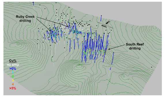
TABLE 14.1: EXPLORATION DATA WITHIN THE RUBY CREEK RESOURCE AREA
| Company |
Years |
Number of Drill Holes |
Number of
Samples |
Total Sample
Length (m) |
| Kennecott | 1957-1997 | 158 | 6,898 | 11,934 |
| NovaCopper | 2011 | 6 | 1,873 | 2,457 |
TABLE 14.2: EXPLORATION DATA WITHIN THE SOUTH REEF RESOURCE AREA
Company |
Years |
Number of Drill Holes |
Number of
Samples |
Total Sample
Length (m) |
| Kennecott | 1957-1997 | 13 | 3,585 | 4,554 |
| NovaCopper | 2011-2012 | 29 | 11,919 | 14,322 |
Historic drilling at the Bornite Project was conducted by Kennecott, a leading technical exploration company during its tenure, known for rigorously controlled drilling programs which typically included the insertion of quality control samples. Unfortunately, records from the Kennecott-era are incomplete and direct validation of portions of the database cannot be made.
| Page 14-4 |
| January 31, 2013 |
|
UPPER KOBUK MINERAL PROJECTS |
| BORNITE DEPOSIT – SOUTH REEF AND RUBY CREEK ZONES | |
| ALASKA, USA | |
| NI 43-101 TECHNICAL REPORT | |
The Qualified Person confirmed the validity of the Kennecott assays in the Ruby Creek zone through comparisons with recent NovaCopper drill results. Comparisons of declustered data sets, derived from the two vintages of drilling, indicate the Kennecott and NovaCopper drilling produce essentially the same results. There is no reason to believe the sample results produced during historic drilling are significantly different from those being generated by NovaCopper. All of the historic drilling has been included in the Ruby Creek mineral resource estimation and there have been no adjustments made to any of this historical data.
Of the 42 drill holes at South Reef, 13 are historic holes drilled by Kennecott. Several of these historic drill holes, located around the periphery of the South Reef mineralization, have no associated assay results. These holes may not have intersected zones of mineralization, or the assay results may be missing. There are only six historic drill holes located close enough to the deposit to have an impact on the estimation of the mineral resources at South Reef. In 2012, NovaCopper re-assayed all available historic (Kennecott) core in the South Reef area. The results of these samples have been validated through the inclusion of blind standards and blanks. The remaining Kennecott drill core for the South Reef zone has been preserved at the Bornite camp.
| 14.4 |
Geologic Model |
Interpretation of the geologic model for the Bornite deposits primarily considered lithologic domains that may influence or control the distribution of copper mineralization. The highest grade parts of the deposits occur within areas where semi-massive and massive sulphides are present. At Ruby Creek, the density of drilling information allowed for the interpretation of a series of massive sulphide domains. The wider-spaced drilling at South Reef does not allow for this level of detailed interpretation and, as a result, a probability shell approach was used to identify areas of higher-grade mineralization.
| 14.4.1 |
Ruby Creek |
Copper mineralization in the Ruby Creek zone occurs within a host sequence of altered carbonate rocks that dip gently towards the north-northeast. The potentially mineralized host unit ranges in thickness from 200 m to 250 m and is bounded by hanging wall dolomitic limestone and footwall quartz phyllite. At Ruby Creek the mineralization is much closer to surface than at South Reef, and most of the hanging wall dolomitic limestone has been eroded. Copper mineralization typically occurs as semi-massive to massive sulphide accumulations that generally mimic the banded nature of the host sequence of carbonates and phyllites.
| Page 14-5 |
| January 31, 2013 |
|
UPPER KOBUK MINERAL PROJECTS |
| BORNITE DEPOSIT – SOUTH REEF AND RUBY CREEK ZONES | |
| ALASKA, USA | |
| NI 43-101 TECHNICAL REPORT | |
A series of six individual massive sulphide lenses were interpreted from the drilling results. The relatively close-spaced drilling at Ruby Creek also allowed for the interpretation and segregation of the (generally) lower grade phyllite zones from the weak to moderately mineralized carbonate domains. An example of the geologic model for Ruby Creek is shown in Figure 14-2.
FIGURE 14-2: CROSS SECTION OF THE RUBY CREEK GEOLOGIC MODEL
![]()
| 14.4.2 |
South Reef |
Similar to Ruby Creek, copper mineralization at South Reef occurs within a host sequence of altered carbonate rocks. A prominent fault or fold is apparent which results in local thickening of the host carbonate stratigraphy. This fault/fold does not appear to have a significant impact on the distribution of copper mineralization in the deposit. Figures 14-3 and 14-4 show perspective views of the general lithologic units of the South Reef zone.
| Page 14-6 |
| January 31, 2013 |
|
UPPER KOBUK MINERAL PROJECTS |
| BORNITE DEPOSIT – SOUTH REEF AND RUBY CREEK ZONES | |
| ALASKA, USA | |
| NI 43-101 TECHNICAL REPORT | |
FIGURE 14-3: GEOLOGIC MODEL SOUTH REEF ZONE
![]()
FIGURE 14-4: GEOLOGIC MODEL SOUTH REEF ZONE
![]()
| Page 14-7 |
| January 31, 2013 |
|
UPPER KOBUK MINERAL PROJECTS |
| BORNITE DEPOSIT – SOUTH REEF AND RUBY CREEK ZONES | |
| ALASKA, USA | |
| NI 43-101 TECHNICAL REPORT | |
Current drilling information at South Reef is considered too widely-spaced to allow for the interpretation of individual massive sulphide domains similar to the approach taken at Ruby Creek; as a result, a probability shell approach has been used to define domains that are more likely to contain significant copper mineralization.
The probability shell is based on a threshold grade of 2% copper. This threshold limit is based primarily on visual observations of the distribution of sample data that suggest that a relatively continuous zone of higher-grade copper mineralization occurs above a threshold grade of 2% copper. It should be noted that approximately 90% of the sample data in the carbonate/phyllite domain at South Reef is below 2% copper and 10% of the data is greater than 2% copper. The initial sample data were composited to 1 m intervals and indicator values were assigned above and below the 2% copper threshold. An indicator variogram was generated and probability values were estimated into model blocks using ordinary kriging. A variety of shells were then tested and it was found that a 30% probability shell forms a relatively continuous domain that honours the sample data. Some minor editing was conducted on the shape of the shell: the elimination of small patches in the shell and limiting of areas where the shell extends irregularly beyond the limits of current drilling. Ultimately, the shell represents areas of the deposit where there is a greater than 30% probability that the grade will be greater than 2% copper. Figure 14-5 shows the shape and extent of the probability shell inside of the carbonate/phyllite domain.
FIGURE 14-5: COPPER PROBABILITY SHELL INSIDE OF CARBONATE / PHYLLITE DOMAIN
![]()
| 14.4.3 |
Summary of Geologic Domains |
The interpreted geologic domains are summarized in Table 14.3.
| Page 14-8 |
| January 31, 2013 |
|
UPPER KOBUK MINERAL PROJECTS |
| BORNITE DEPOSIT – SOUTH REEF AND RUBY CREEK ZONES | |
| ALASKA, USA | |
| NI 43-101 TECHNICAL REPORT | |
TABLE 14.3: SUMMARY OF GEOLOGIC DOMAINS
| Deposit | Geologic Domain |
Ruby Creek |
Hanging wall Dolomite / Limestone – the majority of this has been eroded. |
| Massive Sulphides – high-grade zones of mineralization | |
| Carbonate – contains moderate accumulations of sulphides | |
| Phyllite – generally void of sulphide mineralization | |
| Footwall Quartz Phyllite – contains only minor, local copper mineralization. | |
South Reef |
Hanging wall Dolomite / Limestone – essentially unmineralized. |
| Carbonate / Phyllite domain – Copper probability shell defined within this domain segregating stronger and weaker mineralized areas. | |
| Footwall Quartz Phyllite – contains only minor, local copper mineralization. |
| 14.5 |
Compositing |
Compositing drill hole samples standardizes the database for further statistical evaluation. This step eliminates any effect the sample length may have on the data. To retain the original characteristics of the underlying data, a composite length that reflects the average, original sample length is selected: a too long composite can sometimes result in a degree of smoothing that can mask certain features of the data.
At Ruby Creek, the average sample length is 1.64 m, with the majority of samples collected at 1.5 m intervals. A 5-m composite length was selected for Ruby Creek to be consistent with the 5 m block size, and to avoid segmenting long sample intervals. The 5-m composite length selected for Ruby Creek is consistent with geostatistical practice and ultimately has no impact on the resource model estimation.
At South Reef, the average sample length is 1.22 m, with the majority of samples collected at 1 m intervals; sample length varies depending on local geologic conditions. A 1-m composite length was selected for South Reef.
Drill hole composites are length-weighted and are generated down-the-hole, meaning composites begin at the top of each drill hole and are generated at constant intervals down the length of the hole. Composites were not broken at domain boundaries. Once composites were generated, domain codes were assigned using the interpreted three-dimensional wireframe domains. At Ruby Creek, composites were assigned a specific code if the centroid of the composite occurs within the domain. At South Reef, domain codes were assigned on a majority basis; codes were assigned if the majority of the composite occurs inside the domain boundary. Several holes were randomly selected and the composited values were checked for accuracy. No errors were found.
| Page 14-9 |
| January 31, 2013 |
|
UPPER KOBUK MINERAL PROJECTS |
| BORNITE DEPOSIT – SOUTH REEF AND RUBY CREEK ZONES | |
| ALASKA, USA | |
| NI 43-101 TECHNICAL REPORT | |
| 14.6 |
Exploratory Data Analysis |
Exploratory data analysis (EDA) involves statistically summarizing the database to better understand the characteristics of the data that may control grade. One of the main purposes of EDA is to determine if there is evidence of spatial distinctions in grade. This would require the separation and isolation of domains during interpolation. The application of separate domains prevents unwanted mixing of data during interpolation, and the resulting grade model will better reflect the unique properties of the deposit. However, applying domain boundaries in areas where the data are not statistically unique may impose a bias in the distribution of grades in the model.
A domain boundary, which segregates the data during interpolation, is typically applied if the average grade in one domain is significantly different from another. A domain boundary may also be applied where a significant change in the grade distribution exists across the contact.
| 14.6.1 |
Ruby Creek EDA |
Descriptive statistics were generated from samples in the Ruby Creek zone. The results show that the massive sulphide domains contain very high copper grades; the carbonate zones contain moderate copper accumulations; and, the phyllite zones are essentially unmineralized. The results also show that the hanging wall limestone/dolomite and footwall quartz phyllite contain little to no significant copper mineralization.
Contact profiles evaluate the nature of grade trends between two domains; they graphically display the average grades at increasing distances from the contact boundary. Those contact profiles that show a marked difference in grades across a domain boundary indicate that the two datasets should be isolated during interpolation. Conversely, if a more gradual change in grade occurs across a contact, the introduction of a hard boundary (in other words, segregation during interpolation) may result in much different trends in the grade model; in this case, the change in grade between model domains is often more abrupt than the trends seen in the raw data.
| Page 14-10 |
| January 31, 2013 |
|
UPPER KOBUK MINERAL PROJECTS |
| BORNITE DEPOSIT – SOUTH REEF AND RUBY CREEK ZONES | |
| ALASKA, USA | |
| NI 43-101 TECHNICAL REPORT | |
Finally, a flat contact profile indicates that there are no grade changes across the boundary; in this case, hard or soft domain boundaries will produce similar results in the model.
A series of contact profiles were generated to evaluate the copper trends between geologic domains at Ruby Creek. As expected, the copper content in the massive sulphides significantly differs from surrounding rock types. Figure 14-6 shows that copper grades between the carbonate and phyllite are variable but still considered abrupt enough to segregate these data samples during grade interpolation.
FIGURE 14-6: CONTACT PROFILE SHOWING COPPER IN CARBONATE VERSUS PHYLLITE AT RUBY CREEK
![]()
| 14.6.2 | South Reef EDA |
Summary statistics for South Reef are evaluated using a series of boxplots; these boxplots compare the nature of sample data between various domains. Figure 14-7 shows the distribution of copper between hanging wall (dolomite/limestone), footwall (quartz phyllite), and the carbonate/phyllite domain that hosts the mineralization. The grade differences are quite apparent, showing that the hanging wall and footwall units contain essentially no potentially economic copper concentrations. Figure 14-8 shows the distribution of copper samples inside and outside of the probability shell in the carbonate/phyllite zone (exclusive of the hanging wall and footwall domains). There is a marked difference between these two sets of samples.
| Page 14-11 |
| January 31, 2013 |
|
UPPER KOBUK MINERAL PROJECTS |
| BORNITE DEPOSIT – SOUTH REEF AND RUBY CREEK ZONES | |
| ALASKA, USA | |
| NI 43-101 TECHNICAL REPORT | |
FIGURE 14-7: BOXPLOT COPPER BETWEEN LITHOLOGIC DOMAINS AT SOUTH REEF
![]()
FIGURE 14-8: BOXPLOT COPPER INSIDE/OUTSIDE PROBABILITY SHELL AT SOUTH REEF
![]()
A series of contact profiles were generated to compare copper grades between the various lithologic domains. Figure 14-9 shows that copper grades within the mineralized domain (carbonate/phyllite) are much higher than in the footwall suggesting that a hard boundary should be used during the estimation process between the two domains. The contact between the mineralized domain and the hanging wall is not as sharp, but still there is some evidence that hard boundaries should be applied as well.
| Page 14-12 |
| January 31, 2013 |
|
UPPER KOBUK MINERAL PROJECTS |
| BORNITE DEPOSIT – SOUTH REEF AND RUBY CREEK ZONES | |
| ALASKA, USA | |
| NI 43-101 TECHNICAL REPORT | |
FIGURE 14-9: CONTACT PROFILES SHOWING COPPER BETWEEN LITHOLOGIC DOMAINS AT SOUTH REEF
![]()
Similarly, a contact profile was produced to compare samples inside and outside of the probability shell in the carbonate/phyllite domain (Figure 14-10). This shows that copper grades within the mineralized domain are much higher inside the probability shell compared to outside of the probability shell. The abrupt change in grade across the contact indicates that a hard boundary should be applied during the estimation process.
| Page 14-13 |
| January 31, 2013 |
|
UPPER KOBUK MINERAL PROJECTS |
| BORNITE DEPOSIT – SOUTH REEF AND RUBY CREEK ZONES | |
| ALASKA, USA | |
| NI 43-101 TECHNICAL REPORT | |
FIGURE 14-10: CONTACT PROFILE SHOWING COPPER IN / OUT OF PROBABILITY SHELL AT SOUTH REEF
![]()
| 14.6.3 |
Modelling Implications |
Grade estimates for the Bornite deposits are restricted to the carbonate/phyllite rocks that potentially host appreciable copper concentrations. The hanging wall dolomite/limestone and footwall quartz phyllite show little or no signs of hosting potentially economic resources and, as a result, grade estimations have not been conducted in these lithologic units.
The results of exploratory data analysis (EDA) at Ruby Creek indicate that the distribution of copper differs between the massive sulphide, carbonate, and phyllite domains and samples contained within each should be segregated during the development of the resource model.
At South Reef, EDA on samples in the carbonate/phyllite domain indicates that the probability shell contains samples that significantly differ from surrounding data and that this shell domain should be used as a hard boundary during the estimation of copper in the model.
A summary of the estimation domains is shown in Table 14.4.
| Page 14-14 |
| January 31, 2013 |
|
UPPER KOBUK MINERAL PROJECTS |
| BORNITE DEPOSIT – SOUTH REEF AND RUBY CREEK ZONES | |
| ALASKA, USA | |
| NI 43-101 TECHNICAL REPORT | |
TABLE 14.4: SUMMARY OF ESTIMATION DOMAINS
| Deposit | Estimation Domain |
Ruby Creek |
Massive Sulphides – high-grade zones of mineralization |
| Carbonate – contains moderate accumulations of sulphides | |
| Phyllite – generally void of sulphide mineralization | |
South Reef |
Inside copper probability shell – high-grade zone |
| Outside copper probability shell – low and medium grade zone. |
| 14.7 |
Treatment of Outlier Grades |
Histograms and probability plots were generated from composited sample data to show the distribution of copper in each estimation domain. These were used to identify the existence of anomalous outlier grades in the composite database. The physical locations of these potential outlier samples were reviewed in relation to the surrounding data. At Ruby Creek, it was decided that the effects of these potentially anomalous samples could be controlled through the use of outlier limitations during block grade interpolation. An outlier limitation approach limits samples above a defined threshold to a maximum distance of influence during grade estimates. At South Reef, high-grade copper samples were controlled using a combination of traditional top-cutting and outlier limitations.
At Ruby Creek, 5-m composited samples containing greater than 10% copper in any domain are limited to a maximum distance of influence of 20 m laterally and 10 m vertically, during block grade estimation. Overall, this approach resulted in a 14% reduction in the total contained metal in the deposit.
At South Reef, seven 1-m composite samples inside the probability shell domain have been top-cut to a grade of 25% copper. During interpolation inside the probability shell, composites that exceeded a grade of 10% copper were limited to a maximum distance of influence of 50 m. Outside of the probability shell, composites greater than 10% copper were restricted to a maximum distance of influence of 25 m. Overall, these limitations resulted in a 10.2% loss in copper metal in the resource model.
Table 14.5 summarizes the treatment of outlier sample data and the resulting effects on the estimate of contained metal in the models.
| Page 14-15 |
| January 31, 2013 |
|
UPPER KOBUK MINERAL PROJECTS |
| BORNITE DEPOSIT – SOUTH REEF AND RUBY CREEK ZONES | |
| ALASKA, USA | |
| NI 43-101 TECHNICAL REPORT | |
TABLE 14.5: SUMMARY OF TREATMENT OF OUTLIER SAMPLE DATA – RUBY CREEK & SOUTH REEF
| Deposit |
Element,
Domain, and Limits |
Resulting Metal
Loss in Model |
| Ruby Creek | 5 m composites >10% copper limited to maximum distance of influence of 20m laterally and 10m vertically during grade interpolation. | -14.0% |
| South Reef | Inside Probability shell – 1m composites >25%Cu cut to 25% and composites >10%Cu were limited to maximum distance of 50m during interpolation. | -10.2% |
| Outside Probability shell – 1m composites >10%Cu limited to maximum distance of 25m during interpolation. |
| 14.8 |
Specific Gravity Data |
Specific gravity measurements were conducted on 2,515 samples in the database and range from a minimum of 2.12 t/m3 to a maximum of 8.3 t/m3 and average 2.92 t/m3. Density measurements are relatively sparse at Ruby Creek, available only in holes drilled by NovaCopper in 2011. The majority of drill holes at South Reef have specific gravity measurements conducted at 10 m intervals within unmineralized rock, and at 3 m intervals within the mineralized carbonate/phyllite domain.
There are insufficient data available at Ruby Creek to support interpolating specific gravity values in the block model. Statistical comparisons show a reasonable correlation between copper grade and specific gravity and, as a result, an approach was adopted that assigns specific gravity values to model blocks based on the estimated copper grade. The assigned values are summarized in Table 14.6. The default specific gravity for unmineralized to weakly mineralized material at Ruby Creek is 2.9 t/m3.
| Page 14-16 |
| January 31, 2013 |
|
UPPER KOBUK MINERAL PROJECTS |
| BORNITE DEPOSIT – SOUTH REEF AND RUBY CREEK ZONES | |
| ALASKA, USA | |
| NI 43-101 TECHNICAL REPORT | |
TABLE 14.6: SPECIFIC GRAVITY VALUES ASSIGNED TO MODEL BLOCKS AT RUBY CREEK
%Cu Bin |
Assigned SG
gm/cm3 |
| <0.5 | 2.90 |
| 0.5 - 1.0 | 2.99 |
| 1.0 - 3.0 | 3.00 |
| 3.0 - 5.0 | 3.04 |
| 5.0 - 10.0 | 3.21 |
| 10.0 - 15.0 | 3.43 |
| 15.0 - 20.0 | 3.99 |
| > 20 | 4.02 |
At South Reef, there are sufficient specific gravity data to allow for the interpolation of density values into model blocks.
| 14.9 |
Variography |
The degree of spatial variability and continuity in a mineral deposit depend on both the distance and direction between points of comparison. Typically, the variability between samples is proportionate to the distance between samples. If the variability is related to the direction of comparison, then the deposit is said to exhibit anisotropic tendencies which can be summarized by an ellipse fitted to the ranges in the different directions. The semi-variogram is a common function used to measure the spatial variability within a deposit.
The components of the variogram include the nugget, the sill, and the range. Often samples compared over very short distances (including samples from the same location) show some degree of variability. As a result, the curve of the variogram often begins at a point on the y-axis above the origin; this point is called the nugget. The nugget is a measure of not only the natural variability of the data over very short distances, but also a measure of the variability which can be introduced due to errors during sample collection, preparation, and assaying.
Typically, the amount of variability between samples increases as the distance between the samples increase. Eventually, the degree of variability between samples reaches a constant or maximum value; this is called the sill, and the distance between samples at which this occurs is called the range.
The spatial evaluation of the data was conducted using a correlogram instead of the traditional variogram. The correlogram is normalized to the variance of the data and is less sensitive to outlier values; this generally gives cleaner results.
| Page 14-17 |
| January 31, 2013 |
|
UPPER KOBUK MINERAL PROJECTS |
| BORNITE DEPOSIT – SOUTH REEF AND RUBY CREEK ZONES | |
| ALASKA, USA | |
| NI 43-101 TECHNICAL REPORT | |
Correlograms were generated for the distribution of copper using the commercial software package Sage 2001© developed by Isaacs & Co.
| 14.9.1 |
Ruby Creek Variography |
At Ruby Creek, a variogram could not be produced in the massive sulphide domain due to a lack of samples data. The carbonate variogram was used to estimate copper in the massive sulphide domain. Correlograms are summarized in Table 14.7.
TABLE 14.7: VARIOGRAM PARAMETERS – RUBY CREEK
| 1st Structure | 2nd Structure | ||||||||
Domain |
Nugget |
S1 |
S2 |
Range (m) |
AZ |
Dip |
Range (m) |
AZ |
Dip |
| Carbonate / Massive Sulphide |
0.3 | 0.447 | 0.253 | 31 | 80 | 5 | 737 | 33 | -25 |
Spherical |
12 | 80 | 7 | 71 | 47 | 65 | |||
| 10 | 341 | 60 | 40 | 125 | -5 | ||||
Phyllite |
0.3 | 0.69 | 0.01 | 44 | 40 | -64 | 296 | 97 | -10 |
Spherical |
7 | 83 | 19 | 247 | 180 | 34 | |||
| 4 | 347 | 16 | 107 | 21 | 54 | ||||
Note: Correlograms generated from 5 m composited sample data.
| 14.9.2 |
South Reef Variography and Trend Plane Analysis |
A three-dimensional plane was interpreted through the South Reef zone that represents the general trend of the copper mineralization. This “trend plane” was used as a datum to control search orientations during subsequent interpolations in the model. This dynamic search orientation approach replicates the trends and undulations of the distribution of mineralization in the resource model. The shape and location of this trend plane is shown in Figure 14-11. The correlograms at South Reef were generated using distances relative to the trend plane rather than the true sample elevations. This approach essentially flattens out the zone during interpolation relative to the defined trend plane. Correlograms for the South Reef are summarized in Table 14.8.
| Page 14-18 |
| January 31, 2013 |
|
UPPER KOBUK MINERAL PROJECTS |
| BORNITE DEPOSIT – SOUTH REEF AND RUBY CREEK ZONES | |
| ALASKA, USA | |
| NI 43-101 TECHNICAL REPORT | |
FIGURE 14-11: PLANE REPRESENTING THE GENERAL TREND OF COPPER MINERALIZATION AT SOUTH REEF
![]()
TABLE 14.8: VARIOGRAM PARAMETERS – COPPER AT SOUTH REEF
| 1st Structure | 2nd Structure | ||||||||
| Element / Domain |
Nugget |
S1 |
S2 |
Range (m) |
AZ |
Dip |
Range (m) |
AZ |
Dip |
| Copper – In Prob. Shell |
0.3 | 0.676 | 0.024 | 118 | 33 | 14 | 491 | 115 | 52 |
Spherical |
72 | 288 | 48 | 392 | 1 | 17 | |||
| 11 | 134 | 39 | 27 | 80 | -32 | ||||
| Copper – Out Prob. Shell |
0.15 | 0.707 | 0.014 | 59 | 56 | -4 | 809 | 61 | 24 |
Spherical |
50 | 327 | 12 | 808 | 348 | -33 | |||
| 15 | 131 | 77 | 104 | 302 | 47 | ||||
Note: Correlograms generated from 1 m composited sample data relative to plane representing the trend of mineralization.
| 14.10 |
Model Setup and Limits |
Block models were initialized with the dimensions shown in Tables 14.9 and 14.10. A nominal block size of 5 x 5 x 5 m is considered appropriate for both zones, based on current drill hole spacing, and the selective mining unit (SMU) size that is considered appropriate for deposits of this type and scale.
| Page 14-19 |
| January 31, 2013 |
|
UPPER KOBUK MINERAL PROJECTS |
| BORNITE DEPOSIT – SOUTH REEF AND RUBY CREEK ZONES | |
| ALASKA, USA | |
| NI 43-101 TECHNICAL REPORT | |
TABLE 14.9: BLOCK MODEL LIMITS – RUBY CREEK
| Direction |
Minimum (m) |
Maximum (m) |
Block size
(m) |
Number of Blocks |
| X-axis (W-E) | 588500 | 591000 | 5 | 500 |
| Y-axis (N-S) | 7438500 | 7441300 | 5 | 560 |
| Elevation | -600 | 400 | 5 | 200 |
TABLE 14.10: BLOCK MODEL LIMITS – SOUTH REEF
| Direction |
Minimum (m) |
Maximum (m) |
Block size
(m) |
Number of Blocks |
| X-axis (W-E) | 589800 | 590800 | 5 | 200 |
| Y-axis (N-S) | 7439500 | 7440900 | 5 | 280 |
| Elevation | -700 | 400 | 5 | 220 |
Using the domain wireframes, blocks in the model are assigned zone code values on a majority basis. Blocks with more than 50 percent of their volume inside a wireframe domain are assigned a zone code value of that domain.
| 14.11 |
Interpolation Parameters |
Ruby Creek and South Reef copper grades were estimated using ordinary kriging. The ordinary kriging models were evaluated using a series of validation approaches as described in Section 14.12 of this report. The interpolation parameters have been adjusted until the appropriate results were achieved. In general, the ordinary kriging models have been generated using a relatively limited number of composited sample data. This approach reduces the amount of smoothing (also known as averaging) in the model and, while there may be some uncertainty on a localized scale, this approach produces reliable estimates of the potentially recoverable grade and tonnage for the overall deposit Interpolation parameters for the Ruby Creek and South Reef zones are shown in Tables 14.11 and 14.12.
| Page 14-20 |
| January 31, 2013 |
|
UPPER KOBUK MINERAL PROJECTS |
| BORNITE DEPOSIT – SOUTH REEF AND RUBY CREEK ZONES | |
| ALASKA, USA | |
| NI 43-101 TECHNICAL REPORT | |
TABLE 14.11: INTERPOLATION PARAMETERS – RUBY CREEK
Element/Domain |
Search
Ellipse Range (m) |
Number of
Composites (5 m) |
Other | ||||
| X | Y | Z | Min/block | Max/block | Max/hole | ||
| Copper (all domains) |
300 | 300 | 40 | 1 | 12 | 2 | |
(1) Ellipse inclined at bearing of 30 degrees and plunge of -15 degrees
TABLE 14.12: INTERPOLATION PARAMETERS – SOUTH REEF
Element/Domain |
Search Ellipse
Range (m) |
Number of
composites (1 m) |
Other | ||||
| X | Y | Z (1) | Min/block | Max/block | Max/hole | ||
| Copper In/out Prob. Shell |
500 |
500 |
10 |
5 |
21 |
7 |
OK (1 DH per octant) |
| Specific Gravity | 500 | 500 | 25 | 1 | 21 | 7 | ID2 |
(1) Vertical range relative to distances from trend plane of mineralization
During grade estimation at South Reef, search orientations were designed to follow the mineralization trend surface interpreted to represent the general trend of the mineralization in the deposit. Although the maximum XY range is set at 500 m, estimation of block grades is limited to the nearest 3 or 4 drill holes; this criterion is typically met within a maximum distance of less than 150 m at South Reef.
Block estimates of specific gravity at South Reef are done using the inverse distance (ID2) interpolation method and the probability shell was recognized as a hard boundary domain.
| 14.12 |
Block Model Validation |
The block models were validated through several methods: a thorough visual review of the model grades in relation to the underlying drill hole sample grades; comparisons with the change of support model; comparisons with other estimation methods; and, grade distribution comparisons using swath plots.
| 14.12.1 |
Visual Inspection |
Detailed visual inspections of the Ruby Creek and South Reef block models were conducted in both section and plan to compare estimated grades against underlying sample data. This included confirmation of the proper coding of blocks within the respective zone domains. The distribution of block copper grades and specific gravity estimates were compared relative to the drill hole samples to ensure proper representation in the model. Examples of the distribution of the block model grades are shown in cross section in Figures 14-12 and 14-13.
| Page 14-21 |
| January 31, 2013 |
|
UPPER KOBUK MINERAL PROJECTS |
| BORNITE DEPOSIT – SOUTH REEF AND RUBY CREEK ZONES | |
| ALASKA, USA | |
| NI 43-101 TECHNICAL REPORT | |
FIGURE 14-12: NNE-TRENDING VERTICAL SECTION OF THE BLOCK MODEL AND ESTIMATION DOMAINS AT RUBY CREEK
![]()
| Page 14-22 |
| January 31, 2013 |
|
UPPER KOBUK MINERAL PROJECTS |
| BORNITE DEPOSIT – SOUTH REEF AND RUBY CREEK ZONES | |
| ALASKA, USA | |
| NI 43-101 TECHNICAL REPORT | |
FIGURE 14-13: VERTICAL CROSS SECTION OF BLOCK MODEL AND DRILL HOLE GRADES AT SOUTH REEF
![]()
| 14.12.2 |
Model Checks for Change of Support |
The relative degree of smoothing in the block estimates was evaluated using the Hermitian Polynomial Change of Support (Herco) method, also known as the Discrete Gaussian Correction (Journel and Huijbregts, 1978). With this method, the distribution of the hypothetical block grades can be directly compared to the estimated ordinary kriging model through the use of pseudo-grade/tonnage curves. Adjustments are made to the block model interpolation parameters until an acceptable match is made with the Herco distribution. In general, the estimated model should be slightly higher in tonnage and slightly lower in grade when compared to the Herco distribution at the projected cut-off grade. These differences account for selectivity and other potential ore-handling issues which commonly occur during mining.
The Herco distribution is derived from the declustered composite grades which have been adjusted to account for the change in support moving from smaller drill hole composite samples to the larger blocks in the model. The transformation results in a less skewed distribution, but with the same mean as the original declustered samples. Examples of Herco plots from the copper models at Ruby Creek and South Reef are shown in Figures 14-14 and 14-15, respectively.
| Page 14-23 |
| January 31, 2013 |
|
UPPER KOBUK MINERAL PROJECTS |
| BORNITE DEPOSIT – SOUTH REEF AND RUBY CREEK ZONES | |
| ALASKA, USA | |
| NI 43-101 TECHNICAL REPORT | |
FIGURE 14-14: HERCO AND MODEL GRADE / TONNAGE PLOTS FOR COPPER AT RUBY CREEK
![]()
FIGURE 14-15: HERCO AND MODEL GRADE / TONNAGE PLOTS FOR COPPER AT SOUTH REEF – INSIDE AND OUTSIDE THE PROBABILITY SHELL
![]()
Overall, the desired degree of correlation between models has been achieved. It should be noted that the change of support model is a theoretical tool intended to direct model estimation. There is uncertainty associated with the change of support model, and its results should not be viewed as a final or correct value. In cases where the model grades are greater than the change of support grades, the model is relatively insensitive to any changes to the modelling parameters. Any extraordinary measures to make the grade curves change are not warranted.
| Page 14-24 |
| January 31, 2013 |
|
UPPER KOBUK MINERAL PROJECTS |
| BORNITE DEPOSIT – SOUTH REEF AND RUBY CREEK ZONES | |
| ALASKA, USA | |
| NI 43-101 TECHNICAL REPORT | |
| 14.12.3 |
Comparison of Interpolation Methods |
For comparison purposes, additional grade models were generated for South Reef using the inverse distance weighted (ID2) and nearest neighbour (NN) interpolation methods. The NN model was created using data composited to 5 m lengths to ensure all sample data are used in the model. The results of these models are compared to the ordinary kriging (OK) models at various cut-off grades using a grade/tonnage graph shown in Figure 14-16. There is good correlation between model types.
FIGURE 14-16: COMPARISON OF COPPER MODEL TYPES AT SOUTH REEF
![]()
| 14.12.4 |
Swath Plots (Drift Analysis) |
A swath plot is a graphical display of the grade distribution derived from a series of bands, or swaths, generated in several directions throughout the deposit. Using the swath plot, grade variations from the ordinary kriging model are compared to the distribution derived from the declustered nearest neighbour grade model.
On a local scale, the nearest neighbour model does not provide reliable estimations of grade, but, on a much larger scale, it represents an unbiased estimation of the grade distribution based on the underlying data. Therefore, if the ordinary kriging model is unbiased, the grade trends may show local fluctuations on a swath plot, but the overall trend should be similar to the nearest neighbour distribution of grade.
| Page 14-25 |
| January 31, 2013 |
|
UPPER KOBUK MINERAL PROJECTS |
| BORNITE DEPOSIT – SOUTH REEF AND RUBY CREEK ZONES | |
| ALASKA, USA | |
| NI 43-101 TECHNICAL REPORT | |
Swath plots were generated in three orthogonal directions that compare the ordinary kriging and nearest neighbour estimates for copper in the deposits.
An example from Ruby Creek is shown in Figure 14-17. The results suggest there is good correlation between the models; the degree of smoothing in the ordinary kriging model is evident in the peaks and valleys shown in the swath plots.
Examples from South Reef are shown in Figure 14-18. The results suggest that the ordinary kriging model estimate inside of the probability shell is slightly more conservative than the nearest neighbour model. The differences in the last several swaths are due to the small number of blocks in those swaths and, therefore, the differences are considered inconsequential.
FIGURE 14-17: SWATH PLOTS OF COPPER IN CARBONATE DOMAIN AT RUBY CREEK
![]()
| Page 14-26 |
| January 31, 2013 |
|
UPPER KOBUK MINERAL PROJECTS |
| BORNITE DEPOSIT – SOUTH REEF AND RUBY CREEK ZONES | |
| ALASKA, USA | |
| NI 43-101 TECHNICAL REPORT | |
FIGURE 14-18: SWATH PLOTS OF COPPER MODELS IN/OUT OF THE PROBABILITY SHELL AT SOUTH REEF
![]()
| 14.13 |
Resource Classification |
The mineral resources were classified in accordance with the CIM Definition Standards for Mineral Resources and Mineral Reserves (November, 2010). The classification parameters are defined relative to the distance between sample data and are intended to encompass zones of reasonably continuous mineralization that exhibit the desired degree of confidence in the estimate.
The classification parameters used at Ruby Creek and South Reef are summarized in this section. In both cases, these parameters were applied directly and then manually manipulated to remove artifacts and produce contiguous volumes of classification.
| 14.13.1 |
Ruby Creek Classification Criteria |
The classification parameters used at Ruby Creek are based on variogram analysis and visual interpretation of the nature of the mineralization and are defined as follows:
-
Indicated Mineral Resources require a minimum of three drill holes within a maximum distance of 50 m and form relatively continuous mineralized zones.
| Page 14-27 |
| January 31, 2013 |
|
UPPER KOBUK MINERAL PROJECTS |
| BORNITE DEPOSIT – SOUTH REEF AND RUBY CREEK ZONES | |
| ALASKA, USA | |
| NI 43-101 TECHNICAL REPORT | |
-
Inferred Mineral Resources require a minimum of two drill holes within a maximum distance of 88 m. The Inferred parameters are based on the assumption that drilling exists at a maximum grid spacing of 125 m.
| 14.13.2 |
South Reef Classification Criteria |
Evaluation of indicator variograms (>1% copper using 5 m composite data) from South Reef suggest similar ranges of continuity to those observed at Ruby Creek. However, the Ruby Creek classification parameters for Inferred resources are not directly applicable at South Reef because the South Reef deposit remains “open” at depth. At South Reef, the two-hole requirement for Inferred mineral resources truncates the down dip potential of the resource in a manner that is not considered appropriate at this stage of evaluation of the deposit. As a result, classification parameters for South Reef account for the current drilling configuration are easy to describe and apply, and are similar, in effect, to those used at Ruby Creek. Resources in the Inferred category at South Reef include model blocks that are within a maximum distance of 100 m from a drill hole. This distance criterion is reduced to approximately 60 m along the northern (down-dip) part of the deposit. The deposit exhibits thick intervals of relatively high-grade mineralization that remain “open” based on current drilling. It is felt that this is a more appropriate approach for retaining the desired degree of confidence in the mineral resource estimate at South Reef. Currently there are no resources that exhibit the degree of confidence required to be in the Indicated category at South Reef.
The classification parameters used at South Reef are based on variogram analysis and visual interpretation of the nature of the mineralization and are defined as follows:
Inferred Mineral Resources require a minimum of one drill hole within a maximum distance of 100 m and exhibit reasonable confidence in the grade and continuity of mineralization.
| 14.14 |
Mineral Resource Statement |
CIM Definition Standards for Mineral Resources and Mineral Reserves defines a mineral resource as:
“(A) concentration or occurrence of diamonds, natural solid inorganic material, or natural solid fossilized organic material including base and precious metals, coal, and industrial minerals in or on the Earth’s crust in such form and quantity and of such grade or quantity that it has reasonable prospects for economic extraction. The location, quantity, grade geological characteristics and continuity of a Mineral Resource are known, estimated or interpreted from specific geological evidence and knowledge”.
| Page 14-28 |
| January 31, 2013 |
|
UPPER KOBUK MINERAL PROJECTS |
| BORNITE DEPOSIT – SOUTH REEF AND RUBY CREEK ZONES | |
| ALASKA, USA | |
| NI 43-101 TECHNICAL REPORT | |
The Ruby Creek deposit is located close to surface and, as a result, is potentially amenable to surface mining extraction methods. The “reasonable prospects for economic extraction” were originally tested using a pit shell based on reasonable technical and economic assumptions (US$3.00/lb copper price, US$1.50/t mining cost, US$10.00/t processing cost, a pit slope of 45 degrees, and 100% mining and metallurgical recoveries). The Ruby Creek resource has been re-evaluated at a projected copper price of US$2.75/lb and this change has no appreciable effect on the reported mineral resource.
The South Reef deposit is a relatively continuous zone of moderate- to high-grade copper mineralization that occurs at depths between 350 m and 750 m below surface. The location, shape, and nature of the deposit suggest that any or all of the deposit is potentially amenable to underground mining methods. Based on assumptions of a projected copper price of US$2.75/lb and total site operating costs of US$60.00/t, mineral resources above a base case cut-off grade of 1% copper are considered to pass the test for reasonable economic viability.
It is important to recognize that these discussions of underground and surface mining parameters are used solely for the purpose of testing the “reasonable prospects for economic extraction,” and do not represent an attempt to estimate mineral reserves. There are no mineral reserves calculated for the Bornite Project. These preliminary evaluations are used to assist with the preparation of a Mineral Resource Statement and to select appropriate reporting assumptions. Table 14.13 summarizes the estimate of Bornite mineral resources.
There are no known factors related to environmental, permitting, legal, title, taxation, socioeconomic, marketing, or political issues which could materially affect the mineral resource.
TABLE 14.13: ESTIMATE OF MINERAL RESOURCES – BORNITE
Deposit |
Cut-off (Cu %) |
Mtonnes |
Cu% |
Cu (Mlbs) |
| Indicated | ||||
| Ruby Creek | 0.5 | 6.8 | 1.19 | 179 |
| Inferred | ||||
| South Reef | 1.0 | 43.1 | 2.54 | 2,409 |
| Ruby Creek | 0.5 | 47.7 | 0.84 | 883 |
| Total Inferred | 90.8 | 1.64 | 3,292 | |
| Page 14-29 |
| January 31, 2013 |
|
UPPER KOBUK MINERAL PROJECTS |
| BORNITE DEPOSIT – SOUTH REEF AND RUBY CREEK ZONES | |
| ALASKA, USA | |
| NI 43-101 TECHNICAL REPORT | |
Mineral Resources are not Mineral Reserves and do not have demonstrated economic viability. There is no certainty that all or any part of the Mineral Resources will be converted into Mineral Reserves.
| 14.15 |
Grade Sensitivity Analysis |
For information purposes, resources are summarized at a series of cut-off thresholds in Tables 14.14 and 14.15. For each zone, the base case cut-off limit, about which the mineral resource statement has been derived, is highlighted. The reader is cautioned that the figures presented in these tables should not be misconstrued with a Mineral Resource Statement. The figures are only presented to show the sensitivity of the block model estimates to the selection of the cut-off grade.
TABLE 14.14: QUANTITIES & GRADE ESTIMATES AT VARYING CUT-OFF GRADES (RUBY CREEK)
| Indicated | Inferred | |||||
| Cut-off %Cu |
Tonnes (millions) |
Grade % Cu |
Pounds (millions) |
Tonnes (millions) |
Grade % Cu |
Pounds (millions) |
| 0.3 | 9.0 | 1.00 | 198.6 | 74.3 | 0.68 | 1113.3 |
| 0.5 | 6.8 | 1.19 | 178.7 | 47.7 | 0.84 | 883.2 |
| 1.0 | 2.4 | 2.03 | 109.3 | 11.4 | 1.31 | 329.8 |
| 1.5 | 1.0 | 3.26 | 71.6 | 1.9 | 1.94 | 82.8 |
| 2.0 | 0.6 | 4.49 | 55.0 | 0.5 | 2.65 | 30.3 |
| 1. |
Base Case is 0.5% Cu cut-off grade. |
| 2. |
Mineral Resources are not Mineral Reserves and do not have demonstrated economic viability. There is no certainty that all or any part of the Mineral Resources will be converted into Mineral Reserves. |
| 3. |
Resources stated as contained within a manually constructed potentially economic resource limiting pit shell using metal price of US$3.00/lb Cu, mining costs of US$1.50/tonne, processing costs of US$10.00/tonne, 100% recoveries and an average pit slope of 45 degrees. |
| 4. |
Mineral resource tonnage and contained metal have been rounded to reflect the accuracy of the estimate, and numbers may not add due to rounding. |
| Page 14-30 |
| January 31, 2013 |
|
UPPER KOBUK MINERAL PROJECTS |
| BORNITE DEPOSIT – SOUTH REEF AND RUBY CREEK ZONES | |
| ALASKA, USA | |
| NI 43-101 TECHNICAL REPORT | |
TABLE 14.15: QUANTITIES & GRADE ESTIMATES AT VARYING CUT-OFF GRADES (SOUTH REEF)
| Inferred | |||
| Cut-off %Cu |
Tonnes (millions) |
Grade % Cu |
Pounds (millions) |
| 0.5 | 104.3 | 1.46 | 3,344 |
| 1.0 | 43.1 | 2.54 | 2,409 |
| 1.5 | 28.8 | 3.21 | 2,037 |
| 2.0 | 25.0 | 3.44 | 1,896 |
| 2.5 | 21.7 | 3.61 | 1,730 |
| 3.0 | 16.0 | 3.92 | 1,382 |
| 3.5 | 9.5 | 4.38 | 916 |
| 4.0 | 4.9 | 4.99 | 543 |
|
1. |
Base Case is a 1.0% Cu cut-off grade. |
|
2. |
Mineral Resources are not Mineral Reserves and do not have demonstrated economic viability. There is no certainty that all or any part of the Mineral Resources will be converted into Mineral Reserves. |
|
3. |
Mineral Resources at a 1% cut-off are considered as potentially economically viable in an underground mining scenario based on an assumed projected copper price of US$2.75/lb and total site operating costs of US$60.00/tonne. |
|
4. |
Mineral resource tonnage and contained metal have been rounded to reflect the accuracy of the estimate, and numbers may not add due to rounding. |
| Page 14-31 |
| January 31, 2013 |
|
UPPER KOBUK MINERAL PROJECTS |
| BORNITE DEPOSIT – SOUTH REEF AND RUBY CREEK ZONES | |
| ALASKA, USA | |
| NI 43-101 TECHNICAL REPORT | |
| 15 |
MINERAL RESERVE ESTIMATES |
The Bornite Project is an early exploration project; there are presently no mineral reserves at the Project.
| Page 15-32 |
| January 31, 2013 |
|
UPPER KOBUK MINERAL PROJECTS |
| BORNITE DEPOSIT – SOUTH REEF AND RUBY CREEK ZONES | |
| ALASKA, USA | |
| NI 43-101 TECHNICAL REPORT | |
| 16 |
MINING METHODS |
The Bornite Project is an early exploration project; no mining method has been evaluated for the Project.
| Page 16-1 |
| January 31, 2013 |
|
UPPER KOBUK MINERAL PROJECTS |
| BORNITE DEPOSIT – SOUTH REEF AND RUBY CREEK ZONES | |
| ALASKA, USA | |
| NI 43-101 TECHNICAL REPORT | |
| 17 |
RECOVERY METHODS |
The Bornite Project is an early exploration project; no recovery methods have been investigated for the Project.
| Page 17-1 |
| January 31, 2013 |
|
UPPER KOBUK MINERAL PROJECTS |
| BORNITE DEPOSIT – SOUTH REEF AND RUBY CREEK ZONES | |
| ALASKA, USA | |
| NI 43-101 TECHNICAL REPORT | |
| 18 |
PROJECT INFRASTRUCTURE |
Although Bornite and the greater UKMP, particularly the Arctic deposit (PEA, March 2012), are still in the exploration phase, NovaCopper and NANA are supporting Alaska's efforts to develop infrastructure into the region under the ‘Alaska Road to Resources’ program. Between 2009 and 2012, the state of Alaska funded over US$10 million to study access to the Ambler mining district. During that period, a working group consisting of the Alaska Department of Transportation (ADOT), the Governor’s office, Alaska Industrial Development and Export Authority (AIDEA), NANA Regional Corporation, and NovaCopper was developed to advance the Project.
Efforts from 2009 to 2011 focused on identifying optimal access routes and, after input from local communities and a review of a series of options, the Brooks East Access Route was chosen for further assessment. In 2012, the Alaska State Legislature approved an additional US$4 million to allow the ADOT to initiate environmental baseline studies on the Brooks East Access Route connecting the Ambler district with the Dalton Highway 220 miles to the east. In the fall of 2012, a Project description was prepared by the Project proponent to finalize the proposed action and identify the lead federal agency for impact analysis and determine the state and federal cooperating agencies to assure permit coordination. This work will lead to the completion of a draft Environmental Impact Statement (EIS) in early 2014. Figure 18-1 shows the preferred access option Brooks East Access Route) in yellow, and a variation of the route in pink.
FIGURE 18-1: BROOKS EAST ROUTE ACCESS TO THE UKMP
![]()
| Page 18-1 |
| January 31, 2013 |
|
UPPER KOBUK MINERAL PROJECTS |
| BORNITE DEPOSIT – SOUTH REEF AND RUBY CREEK ZONES | |
| ALASKA, USA | |
| NI 43-101 TECHNICAL REPORT | |
| 19 |
MARKET STUDIES AND CONTRACTS |
The Bornite Project is an early exploration project; no market studies have been completed.
| Page 19-1 |
| January 31, 2013 |
|
UPPER KOBUK MINERAL PROJECTS |
| BORNITE DEPOSIT – SOUTH REEF AND RUBY CREEK ZONES | |
| ALASKA, USA | |
| NI 43-101 TECHNICAL REPORT | |
| 20 |
ENVIRONMENTAL STUDIES, PERMITTING, AND SOCIAL OR COMMUNITY IMPACT |
| 20.1 |
Baseline Studies |
Since 2007, baseline environmental studies have been completed in the district by various parties; areas of study have included: water quality, hydraulics, sediment, meteorology, wetlands delineation, cultural resources, and asbestos testing. In 2007, NovaGold/NovaCopper began collecting its own baseline data.
2007 Studies
Travis/Peterson Environmental Consulting Inc. completed a site characterization for Bornite. The report identified several safety and environmental issues and possible mitigation solutions. Identified in the report are asbestos-containing structures, petroleum ground contamination, an open shaft which presents a safety hazard, and environmental liabilities due to out of service vehicles. Full results are available in the report, Bornite Mine Camp Site Characterization Report (Travis/Peterson Environmental Consulting, Inc., 2007).
Shaw Alaska Inc. sampled a total of 34 primary surface water locations and seven primary sediment locations associated with the UKMP. Sites were selected on the Shungnak River, Subarctic Creek, Arctic Creek, and the Kogoluktuk River. The samples were analyzed for metals and common environmentally significant parameters. Field parameters were also measured using a handheld YSI unit. Full results are available in the report, Environmental Baseline Sampling Alaska Gold (Crupi, Steven R., 2007).
2008 Studies
Shaw Alaska Inc. measured hydraulic data from thirteen locations related to the UKPM. Velocity, depth, width, and discharge (cubic feet per second) were measured using a Marsh McBirney flow meter. Full results are available in the report, Shaw Hydraulics Data Report (Crupi, Steven R., 2008, Hydraulics).
Shaw Alaska Inc. sampled 13 of the 34 total primary surface water locations originally selected in 2007. Full results are available in the report, Water Quality Report (Crupi, Steven R., 2008, Water Quality).
Northern Land Use Research Inc. (NLUR) surveyed sites associated with the UKMP that could have potential cultural significance, including the Bornite property. The survey looked for historic land use, including trails and sites that could contain artifacts. NLUR concluded "No Historic Properties Affected." Full results are available in the report, Assessment of Cultural Resources and Site Potential of Proposed Geologic Exploration Drill Areas (Neely, Burr, and Proue, Molly, 2008).
| Page 20-1 |
| January 31, 2013 |
|
UPPER KOBUK MINERAL PROJECTS |
| BORNITE DEPOSIT – SOUTH REEF AND RUBY CREEK ZONES | |
| ALASKA, USA | |
| NI 43-101 TECHNICAL REPORT | |
Amerikanuak Inc. assessed the reclamation success of the sites reclaimed in 2007, and sampled water from three existing drill holes at Bornite. The holes were sampled for dissolved metals, nutrients, and low level mercury. Full results are available in the report (Bergstrom, Frank, 2008).
2009 Studies
Shaw Alaska Inc. measured hydraulic data from thirteen gauging stations related to the UKMP. Velocity, depth, width and discharge (cubic feet per second) were measured using a Marsh McBirney current meter. A weir was used to collect data at Subarctic Creek. Full results are available in the report, Hydraulics Data Report (Crupi, Steven R., 2009, Hydraulics).
Shaw Alaska Inc., as in 2008, sampled 13 of the 34 total primary surface water locations associated with the UKMP. Full results are available in the report, Water Quality Report (Crupi, Steven R., 2009, Water Quality)
2010 Studies
TetraTech Inc. conducted environmental baseline work to support permitting of a proposed access road between the Bornite and Arctic mineral deposits. The work consisted of characterizing the hydrology, water quality, and aquatic life in the Shungnak River and tributaries intersecting the proposed access road, including Subarctic Creek, and mapping vegetation and wetlands along the proposed alignments.
The aquatic resources survey sampled fish and macro-invertebrates in water bodies along the Arctic Access Road route including the Shungnak River, Ruby Creek, Subarctic Creek, Unnamed Tributaries, and Kettle Lakes. Fish were sampled using seine nets, gill nets, hoop nets, minnow traps, electro-fishing, and hook and line. Macro-invertebrates were sampled using a framed kick-net. Fish were observed in all rivers and tributaries but not in the Kettle Lakes. The number of fish observed varied from three to four species. Macro-invertebrate sampling revealed that the water bodies are in good ecological health as indicated by their relatively high species diversity and species richness. Full results are available in the report, Arctic Deposit Access Environmental Baseline Data Collection Aquatics (TetraTech, 2010, Aquatics).
The water quality sampling and hydrologic characterizations included three sites in the Shungnak River and nine sites from tributaries, including Subarctic Creek. A total of twelve locations were sampled and analyzed for a suite of dissolved metals, total metals, and non-metal parameters. A comparison of the analytical results indicated that water quality is generally good throughout the study area with most constituents within Alaska State Water Quality Standards (WQS). Any exceeded WQS limits occurred within chronic exposure criteria and not acute conditions. Full results are available in the report, Arctic Deposit Access Environmental Baseline Data Collection Hydrology (TetraTech, 2010, Hydrology)
| Page 20-2 |
| January 31, 2013 |
|
UPPER KOBUK MINERAL PROJECTS |
| BORNITE DEPOSIT – SOUTH REEF AND RUBY CREEK ZONES | |
| ALASKA, USA | |
| NI 43-101 TECHNICAL REPORT | |
Wetlands were identified using the standard three-parameter approach required by the US Army Corps of Engineers. Thirty-three sampling locations were evaluated reflecting the fourteen vegetation communities observed in the field. Vegetation communities were characterized using the Alaska Vegetation Classification system. Taking into consideration topographic position and field observations, the communities were categorized as uplands, wetlands, or a combination of both. To the extent possible, vegetation communities were identified on the area's satellite imagery to create a vegetation and wetland map. Full results are available in the report, Arctic Deposit Access Environmental Baseline Data Collection Wetlands & Vegetation (TetraTech, 2010, Wetlands & Vegetation).
2011 Studies
Using wetland information gathered during the 2010 field season, including with satellite imagery, TetraTech Inc. created a wetlands map of the Bornite area. The map will be used in 2012 to avoid disturbing wetlands whenever possible and to plan drill holes and road routes accordingly. The wetlands map was also used to permit a Class III Municipal Landfill to be located near the Bornite Airstrip.
Soil asbestos sampling was done by the NovaGold on-site Compliance Coordinator. A total of 27 grab samples were collected to create five composite samples from Dahl Creek Camp, the Dahl Creek to Bornite road, Bornite Airstrip, Bornite Camp, and the Arctic deposit. The composite samples were analyzed for the presence or absence of asbestos using Polarized Light Microscopy (PLM) by White Environmental Consultants Inc. All of the composite samples tested negative for asbestos. Full results are available in the report, Ambler Project Asbestos Soil Sampling Report (Craig, C., 2011).
2012 Studies
In late July and early August, two hydraulic gauging stations were installed and operated at the Shungnak River and Subarctic Creek. The purpose of the gauging stations is to build knowledge of hydraulic baseline conditions on Subarctic Creek and the Shungnak River. Full results of the installation are available in the reports, Stream Gauge Install (DOWL HKM, 2012) and Stream Gauge Install (Dryden, James, 2012).
| Page 20-3 |
| January 31, 2013 |
|
UPPER KOBUK MINERAL PROJECTS |
| BORNITE DEPOSIT – SOUTH REEF AND RUBY CREEK ZONES | |
| ALASKA, USA | |
| NI 43-101 TECHNICAL REPORT | |
In September, discharge measurements were collected at the Shungnak River and Subarctic Creek gauging stations. Full results are available in the report, September 2012 Trip Report (DOWL HKM, 2012)
In September, water quality characterization was performed at seven locations. Four of the seven locations were sites sampled previously in 2007, 2008, or 2010. In addition to the four sites previously sampled, three sites were added to incorporate Ruby Creek. Full results are available in the report, Water Quality Monitoring Report (Craig, C., 2012).
Meteorological data were collected at the Arctic Airstrip using an existing weather station. Site data were collected hourly for the following: humidity, barometric pressure, precipitation, solar radiation, temperature, wind speed, and wind direction. Full results are pending in DOWL HKM's 2012 yearend report.
| 20.2 |
Environmental Issues |
Under the NANA Agreement, NANA Regional Corporation, Inc. (NANA) is required to complete a baseline environmental report following completion of cleanup of the former mining camp on the Bornite Lands, to the standards required by the Alaska Department of Environmental Conservation. This includes removal and disposal as required by law of all hazardous substances present on the Bornite Lands. NANA has indemnified and will hold NovaCopper harmless for any loss, cost, expense, or damage suffered or incurred attributable to the environmental condition of the Bornite Lands at the date of the baseline report which relate to any activities prior to the date of the agreement.
In addition, there are no indications of any known environmental impairment or enforcement actions associated with NovaGold’s activities to date. As a result, NovaGold has not incurred outstanding environmental liabilities in conjunction with its entry into the NANA Agreement.
| 20.3 |
Exploration Closure Plan |
Reclamation at the UKMP is completed under the guidelines presented by the State of Alaska in the Multi-Year Hardrock Exploration Permit #2183 issued by the Department of Natural Resources Division of Mining, Land, and Water.
| Page 20-4 |
| January 31, 2013 |
|
UPPER KOBUK MINERAL PROJECTS |
| BORNITE DEPOSIT – SOUTH REEF AND RUBY CREEK ZONES | |
| ALASKA, USA | |
| NI 43-101 TECHNICAL REPORT | |
Key components include the following:
- Topsoil will be stockpiled.
- The area will be reshaped to blend with surrounding topography.
- Organic material will be spread over the site to prevent erosion.
- Reclamation will be done in the same season as disturbance.
- Drill casing will be removed or cut off at ground level.
- Drill holes will be plugged with bentonite clay or equivalent.
- Reseeding will be done as necessary.
- Disturbance will be held to a minimum.
| 20.4 |
Permitting |
Development of the UKMP will require a significant number of permits and authorizations from state, federal, and regional organizations. Much of the groundwork to support a successful permitting effort must be undertaken prior to submission of permit applications so that issues can be identified and resolved, baseline data can be acquired, and regulators and stakeholders can become familiar with the proposed Project.
The comprehensive permitting process for the UKMP can be divided into three categories:
| 1. |
Exploration state/regional permitting: required to obtain approval for drilling, camp operations, engineering, and environmental baseline studies. | |
| 2. |
Pre-application phase: conducted in conjunction with engineering feasibility studies. This stage includes the collection of environmental baseline data and interaction with stakeholders and regulators to facilitate the development of a project that can be successfully permitted. | |
| 3. |
The National Environmental Policy Act (NEPA) phase: formal agency review of the Federal and State requirements for public and agency participation to determine if and how the Project can be done in an acceptable manner. |
Table 20.1 lists the typical permits that may be required for the Project.
| Page 20-5 |
| January 31, 2013 |
|
UPPER KOBUK MINERAL PROJECTS |
| BORNITE DEPOSIT – SOUTH REEF AND RUBY CREEK ZONES | |
| ALASKA, USA | |
| NI 43-101 TECHNICAL REPORT | |
TABLE 20.1: PERMITS THAT MAY BE REQUIRED FOR THE BORNITE PROJECT
| Authority | Permit |
| FEDERAL | |
| Environmental Protection
Agency (EPA) |
Spill Prevention Containment and Contingency (SPCC) Plan |
| U.S. Army Corps
of Engineers (USACE) |
CWA Section 404 Permit (wetlands dredge and fill) |
| River and Harbors Act (RHA)
Section 10 (structures in navigable waters) | |
| RHA Section 9 (dams and dykes
in navigable waters-interstate commerce) | |
| U.S. Coast Guard | RHA Section 9 Construction
Permit (bridge across navigable waters) |
| Bureau of
Alcohol, Tobacco, and Firearms |
License to Transport Explosives |
| Permit and License for Use of Explosives | |
| Federal Aviation
Administration |
Notice of Landing Area Proposal (existing airstrip) |
| Notice of Controlled Firing Area for Blasting | |
| U.S. Department of Transportation | Hazardous Materials Registration |
| U.S. Fish and
Wildlife Service |
Section 7 of the Endangered
Species Act, Consultation requiring a Biological Assessment or Biological Opinion |
| STATE | |
| Division of Mining, Land, and
Water |
Plan of Operations |
| Reclamation Plan Approval | |
| Mining License | |
| Land Use Permits and Leases | |
| Right-of-Ways, Easements, Material Sales, etc. | |
| Certificate of Approval to Construct a Dam | |
| Certificate of Approval to Operate a Dam | |
| Temporary Water Use Permit | |
| Water Rights Permit/Certificate to Appropriate Water | |
| State Historic Preservation Office | Section 106 Historical and
Cultural Resources Protection Act clearance |
| Department of
Fish and Game |
Fish Habitat Permit |
| Wildlife Hazing Permit | |
| Culvert/Bridge Installation Permit |
| Page 20-6 |
| January 31, 2013 |
|
UPPER KOBUK MINERAL PROJECTS |
| BORNITE DEPOSIT – SOUTH REEF AND RUBY CREEK ZONES | |
| ALASKA, USA | |
| NI 43-101 TECHNICAL REPORT | |
TABLE 20.2: PERMITS THAT MAY BE REQUIRED FOR THE BORNITE PROJECT – CONT'D
| Authority | Permit |
| FEDERAL | |
| Division of Water
|
Section 401 Water Quality Certification (CWA 402 permit) |
| Waste water Disposal Permits | |
| Non-Domestic Wastewater Disposal Permit | |
| Storm Water Discharge Pollution Prevention Plan | |
| Domestic Waste water Disposal Permit | |
| Approval to Construct and Operate a Public Water Supply System | |
| Division of
Environmental Health |
Solid Waste Disposal Permits |
| Food Sanitation Permit | |
| Class III Municipal Solid Waste Landfill Permit | |
| Division of Air
Quality |
Air Quality Construction Permit (first 12 months) |
| Air Quality PSD Title V Operating Permit (after 12 months) | |
| Air Quality permit to Open Burn | |
| REGIONAL | |
| Northwest Arctic
Borough |
Title 9 Land Use Permit |
| Fuel Storage Permit | |
| Commercial Transporter Authorization | |
| Master Plan of Operations |
The permit review process will determine the number of management plans required to address all aspects of the Project to ensure compliance with environmental design and permit criteria. Each plan will describe the appropriate environmental engineering standard (for example, secondary containment for petroleum products, process solutions, and reagents) and the applicable operations requirements, maintenance protocols, and response actions.
| Page 20-7 |
| January 31, 2013 |
|
UPPER KOBUK MINERAL PROJECTS |
| BORNITE DEPOSIT – SOUTH REEF AND RUBY CREEK ZONES | |
| ALASKA, USA | |
| NI 43-101 TECHNICAL REPORT | |
| 21 |
CAPITAL AND OPERATING COSTS |
The Bornite Project is an early exploration project; no capital or operating costs have been estimated.
| Page 21-1 |
| January 31, 2013 |
|
UPPER KOBUK MINERAL PROJECTS |
| BORNITE DEPOSIT – SOUTH REEF AND RUBY CREEK ZONES | |
| ALASKA, USA | |
| NI 43-101 TECHNICAL REPORT | |
| 22 |
ECONOMIC ANALYSIS |
The Bornite Project is an early exploration project; no economic analysis has been completed.
| Page 22-1 |
| January 31, 2013 |
|
UPPER KOBUK MINERAL PROJECTS |
| BORNITE DEPOSIT – SOUTH REEF AND RUBY CREEK ZONES | |
| ALASKA, USA | |
| NI 43-101 TECHNICAL REPORT | |
| 23 |
ADJACENT PROPERTIES |
No adjacent property information was used to generate the Bornite resource estimate. The Bornite deposit is located approximately 11 miles (17 km) from NovaCopper’s Arctic deposit.
In addition to the UKMP’s land holdings encompassing Bornite and Arctic, there are two properties adjacent to the UKMP: Sun and Smucker. Sun and Smucker, both located in the Ambler Schist Belt, are analogous to the UKMP’s Arctic deposit, but not to the Bornite deposit. Andover Resources and Teck Cominco own Sun and Smucker, respectively, and neither property has a current NI 43-101 complaint resource.
| 23.1 |
Sun Prospect |
The Sun prospect, also referred to as the Hot prospect, is located 52 miles (83 km) east of Bornite and is described as a polymetallic copper, zinc, lead, and silver VMS deposit. It is in the same terrane and lithological sequence as the UKMP’s Arctic deposit. The deposit is currently in resource development and is being assessed as a potential open pit and underground mine site. Andover Resources owns 100% interest in the property subject to a 1.5% NSR production royalty held by the former owner, Hastings Base Metals Corporation.
| 23.2 |
Smucker Prospect |
This Smucker prospect is located 17 miles (28 km) north-northwest of Bornite in the same terrane and lithological sequence as the Arctic deposit. Like Arctic, it is described as a polymetallic copper, zinc, lead, and silver VMS prospect currently in target delineation. Significant drilling in the 1970s by Anaconda intersected precious metals-rich VMS mineralization analogous to other prospects of the Ambler Schist Belt. There are no published resources or reserve estimates for this Project (www.meg.com, 2007). Teck Cominco owns 100% interest in the property.
| 23.3 |
Arctic Deposit |
In addition to the Bornite deposit discussed herein, NovaCopper also controls the Arctic deposit. The Arctic deposit is located 11 miles (17 km) northeast of Bornite on State of Alaska claims held by NovaCopper, and falls within the NANA Agreement Area of Interest with the NANA Regional Corporation. The deposit has a publicly disclosed copper, zinc, lead, silver, and gold resource that is NI 43-101 compliant. Arctic is the largest and highest grade deposit known in the Ambler Schist Belt. SRK Consulting prepared a preliminary economic assessment (PEA) for NovaGold and its release in March 2012 shows a positive net present value (NPV) at an 8% discount rate and forecasted metal prices (NovaGold, 2011).
| Page 23-1 |
| January 31, 2013 |
|
UPPER KOBUK MINERAL PROJECTS |
| BORNITE DEPOSIT – SOUTH REEF AND RUBY CREEK ZONES | |
| ALASKA, USA | |
| NI 43-101 TECHNICAL REPORT | |
| 24 |
OTHER RELEVANT DATA AND INFORMATION |
There is no other relevant data or information.
| Page 24-1 |
| January 31, 2013 |
|
UPPER KOBUK MINERAL PROJECTS |
| BORNITE DEPOSIT – SOUTH REEF AND RUBY CREEK ZONES | |
| ALASKA, USA | |
| NI 43-101 TECHNICAL REPORT | |
| 25 |
INTERPRETATION AND CONCLUSIONS |
This NI 43-101 Technical Report for the Bornite deposit encompasses: the Ruby Creek resource area, originally filed as a technical report in 2012 based on the assembly and verification of historic Kennecott data and drilling in 2011 by NovaGold/NovaCopper; and, the South Reef resource area based on 2011 and 2012 drilling by NovaGold/NovaCopper.
The following conclusions can be made:
-
The level of understanding of the Bornite deposit geology is relatively good. The practices used during the various drilling campaigns were conducted in a professional manner and adhered to accepted industry standards. There are no evident factors that would lead one to question the integrity of the database.
-
A significant copper deposit continues to be outlined. Mineralization is hosted in stratiform zones occurring in favourable carbonate stratigraphy. There is significant potential to continue to expand the deposit.
-
Drilling to date in the South Reef zone has produced an estimated Inferred resource (at a 1.0% Cu cut-off) of 43.1 Mtonnes of 2.54% Cu.
-
Drilling to date in the Ruby Creek zone has produced an estimated Indicated resource (at a 0.5% Cu cut-off) of 6.8 Mtonnes of 1.19% Cu and an Inferred resource (at a 0.5% Cu cut-off) of 47.7 Mtonnes of 0.84% Cu.
| Page 25-1 |
| January 31, 2013 |
|
UPPER KOBUK MINERAL PROJECTS |
| BORNITE DEPOSIT – SOUTH REEF AND RUBY CREEK ZONES | |
| ALASKA, USA | |
| NI 43-101 TECHNICAL REPORT | |
| 26 |
RECOMMENDATIONS |
The following actions are recommended for the Bornite deposit:
-
Additional drilling to determine the extent of the mineralization in the South Reef zone, especially down dip of the current mineralization. A budget of US$2.0 million is proposed to complete this work.
-
Additional drilling to further define the higher-grade zones in both the Upper and Lower Reefs of the Ruby Creek and South Reef zones. A budget of US$2.0 million is proposed to complete this work.
-
Consolidated exploration program testing for satellite deposits that includes: geophysics, geochemistry, geologic mapping, and drilling. A budget of US$1.5 million is proposed to complete this work.
-
Following next phase of drilling, a preliminary economic assessment that includes: geotechnical work, metallurgical studies, hydrological studies, resource estimation (including further collection and analysis of specific gravity data and further verification and analysis of the historical drilling data), mine planning, and an economic analysis of the Project. A budget of US$1.5 million is proposed to complete this work.
| Page 26-1 |
| January 31, 2013 |
|
UPPER KOBUK MINERAL PROJECTS |
| BORNITE DEPOSIT – SOUTH REEF AND RUBY CREEK ZONES | |
| ALASKA, USA | |
| NI 43-101 TECHNICAL REPORT | |
| 27 |
REFERENCES |
Avé Lallemant, H.G., Gottschalk, R.R., Sisson, V.B., and Oldow, J.S., 1998, Structural analysis of the Kobuk fault zone, north-central Alaska, in Oldow, J.S., and Avé Lallemant, H.G., eds., Architecture of the Central Brooks Range Fold and Thrust Belt, Arctic Alaska: Boulder, Colorado, Geologic Society of America Special Paper 324.
Beisher, G., 2000, Ruby Creek Copper Prospect Bornite Carbonate Sequence, NANA Regional Corporation Lands Northwest Alaska report submitted to M.I.M. (USA) Inc.
Bergstrom, Frank, 2008, Trip Report – Arctic and Bornite, August 13 thru 18, 2008 MEMO, Amerikanuak, Inc.
Bernstein, L.R., and Cox, D.P., 1986, Geology and Sulfide Mineralization of the Number One Orebody, Ruby Creek Copper Deposit, Alaska: Economic Geology, 81, p. 1675-1689
Bigelow, Charles G., 1963, Facies distribution, structure and mineralization, Ruby Creek Development project, Alaska June 1963: Bear Creek Mining company internal report.
Christiansen, P.P. and Snee, L.W., 1994, Structure, metamorphism, and geochronology of the Cosmos Hills and Ruby Ridge, Brooks Range Schist Belt, Alaska: Tectonics, 13, p. 193-213.
CIM. (November 2010). CIM Definition Standards - For Mineral Resources and Mineral Reserves. Retrieved from http://web.cim.org/UserFiles/File/CIM_DEFINITION_STANDARDS_Nov_2010.pdf.
Craig, C., 2011, Ambler Project Asbestos Soil Sampling Report, Internal Report Prepared for the Alaska Gold Company
Craig, C., 2012, 2012 Water Quality Monitoring Report, Internal Report prepared for NovaCopper US Inc.
Crupi, Steven R., 2007, Ambler Project 2007 Environmental Baseline Sampling Alaska Gold Co., Shaw Alaska, Inc.
Crupi, Steven R., 2008, Shaw Hydraulics Data Report July 2008 Event Final, Shaw Environmental, Inc.
Crupi, Steven R., 2008, Water Quality Report July 2008 Event Final, Shaw Environmental, Inc.
Crupi, Steven R., 2009, Hydraulics Data Report July 2009 Event Draft, Shaw Environmental, Inc.
| Page 27-1 |
| January 31, 2013 |
|
UPPER KOBUK MINERAL PROJECTS |
| BORNITE DEPOSIT – SOUTH REEF AND RUBY CREEK ZONES | |
| ALASKA, USA | |
| NI 43-101 TECHNICAL REPORT | |
Crupi, Steven R., 2009, Water Quality Report July 2009 Event Final, Shaw Alaska, Inc.
Davis, Bruce, 2012, Resource Estimate – Ruby Creek Zone, Bornite Deposit, Upper Kobuk Mineral Project, Northwest Alaska, NI 43-101 Technical Report
Dillon, J.T., Pessel, G.H., Chen, J.H., and Veach, N.C., 1980, Middle Paleozoic magmatism and orogenesis in the Brooks Range, Alaska: Geology, 8, p. 338-343.
DOWL HKM, 2012, DOWL HKM September 2012 Trip Report, DOWL HKM
DOWL HKM, 2012, DOWL HKM Stream Gage Install July-August 2012 Trip Report Dryden, James, 2012, Dryden Stream Gage Install Aug 2012 Trip Report
Hale, C., 1996, 1995 Annual Ambler District Report: Kennecott Exploration Internal report.
Hale, C., 1997, Ruby Creek-Cosmos Hills Geology, 1997 Results: Kennecott Exploration Internal report.
Hawke Engineering, 1966, Flooding on October 27, 1966 exploration shaft at Bornite Alaska: Hawk Engineering internal report for Ruby Creek development Kennecott Copper Corp.
Hitzman, M.W., Smith, T.E., and Proffett, J.M., 1982, Bedrock Geology of the Ambler District, Southwestern Brooks Range, Alaska: Alaska Division of Geological and Geophysical Surveys Geologic Report 75, 1:50,000.
Hitzman, M.W., 1983, Geology of the Cosmos Hills and its relationship to the Ruby Creek copper-cobalt deposit: Unpublished Ph.D. dissertation, Stanford, CA, Stanford University, 266p.
Hitzman, M.W., 1986, Geology of the Ruby Creek Copper Deposit: Economic Geology, 81, p. 1644-1674.
Hitzman, M.W., Proffett, J.M., Schmidt, J.M., Smith, T.E., 1986, Geology and Mineralization of the Ambler District, Northwest Alaska: Economic Geology, 81, p. 1592-1618.
Journel A., Huijbregts, C. J. (1978). Mining Geostatics. London: Academic Press.
Lutz, Norman R. 1960, Progress report Ruby Creek thru 1959: Bear Creek Mining Company internal report.
| Page 27-2 |
| January 31, 2013 |
|
UPPER KOBUK MINERAL PROJECTS |
| BORNITE DEPOSIT – SOUTH REEF AND RUBY CREEK ZONES | |
| ALASKA, USA | |
| NI 43-101 TECHNICAL REPORT | |
McClelland, W.C., Schmidt, J.M., and Till, A.B., 2006, New U-Pb SHRIMP ages from Devonian felsic volcanic and Proterozoic plutonic rocks of the southern Brooks Range, AK: Geologic Society of America Abstracts with Programs, v. 38, n. 5, p. 12.
Moore, T.E., 1992, The Arctic Alaska Superterrane, p. 238-244, in Bradley, D.C., and Dusel-Bacon, C., eds., Geologic Studies in Alaska by the U.S. Geological Survey, 1991: U.S. Geological Survey Bulletin 2041.
Moore, T.E., Wallace, W.K, Bird, K.J., Karl, S.M., Mull, C.G., and Dillon, J.T., 1994, Geology of northern Alaska, in Plafker, G., and Berg, H.C., eds., The Geology of Alaska: Boulder, Colorado, Geologic Society of America, The Geology of North America, v. G-1.
NANA Regional Corporation, Inc., 2010, Kobuk Village Profile
Neely, Burr, and Proue, Molly, 2008, Assessment of Cultural Resources and Site Potential of Proposed Geologic Exploration Drill Areas, Northwest Alaska, Northern Land Use Research, Inc.
Penny, C. T., 1966, Annual Report Ruby Creek Division, Kennecott Copper Corp. Internal report.
Penny, C. T., 1968, Review Ruby Creek Division 1964 – 68: Kennecott Exploration Internal report
Ratterman, N.S., McClelland, W.C., and Presnell, R.D., 2006, Geochronology and lithogeochemistry of volcanic rocks of the Ambler District, Southern Brooks Range, Alaska: Geologic Society of America Abstracts with Programs, v. 38, n. 5, p. 69.
Robinson, J., 2010, The Ruby Creek Deposit in 2009, NovaGold Resources Internal report.
Roskowski, J., 2011, Bornite Collar Corrections, NovaCopper Internal memo.
Selby, D., Kelley, K.D., Hitzman, M.W., Zieg, J., 2009, Re-Os sulfide (bornite, chalcopyrite, and pyrite) systematics of the carbonate-hosted copper deposits at Ruby Creek, southwestern Brooks Range, Alaska: Economic Geology, 104, p. 437-444.
TetraTech, 2010, Arctic Deposit Access Environmental Baseline Data Collection Aquatics, TetraTech, Inc.
TetraTech, 2010, Arctic Deposit Access Environmental Baseline Data Collection Hydrology, TetraTech, Inc.
| Page 27-3 |
| January 31, 2013 |
|
UPPER KOBUK MINERAL PROJECTS |
| BORNITE DEPOSIT – SOUTH REEF AND RUBY CREEK ZONES | |
| ALASKA, USA | |
| NI 43-101 TECHNICAL REPORT | |
TetraTech, 2010, Arctic Deposit Access Environmental Baseline Data Collection Wetlands & Vegetation, TetraTech, Inc.
Till, A.B., Dumoulin, J.A., Harris, A.G., Moore, T.E., Bleick, H.A., and Siwiec, B.R., 2008, Bedrock geologic map of the Southern Brooks Range, Alaska and accompanying conodont data: U.S. Geologic Survey Open File Report 2008-1149.
Travis/Peterson Environmental Consulting, Inc., 2007, Bornite Mine Camp Site Characterization Report, prepared for NANA Regional Corporation.
Vogl, J.J., 2003, Thermal-baric structure and P-T history of the Brooks Range metamorphic core, Alaska: Journal of Metamorphic Geology, 21, p. 269-284.
Williams 1988, Bornite Data Summaries internal report, Kennecott Internal report.
Zimmerley, S. R, 1961, Amenability of Samples from the Ruby Creek, Alaska, Copper Prospect – Exploration Lot D-378, Letter to R. D. Hutchinson, District Geologist, Bear Creek Mining Company.
| Page 27-4 |
| January 31, 2013 |
|
UPPER KOBUK MINERAL PROJECTS |
| BORNITE DEPOSIT – SOUTH REEF AND RUBY CREEK ZONES | |
| ALASKA, USA | |
| NI 43-101 TECHNICAL REPORT | |
| 28 |
CERTIFICATES AND SIGNATURES |
Bruce Davis, FAusIMM, BD Resource Consulting, Inc.
I, Bruce Davis, FAusIMM, do hereby certify that:
| 1. |
I am an independent consultant of BD Resource Consulting, Inc., located at 4253 Cheyenne Drive, Larkspur, CO, U.S.A., 80118, and incorporated January 18, 2008. | |
| 2. |
I graduated with a Doctor of Philosophy degree from the University of Wyoming in 1978. | |
| 3. |
I am a fellow of the Australasian Institute of Mining and Metallurgy, Registration Number 2111185. | |
| 4. |
I have practiced my profession continuously for 34 years and have been involved in geostatistical studies, mineral resource and reserve estimations and feasibility studies on numerous underground and open pit base metal and gold deposits in Canada, the United States, Central and South America, Europe, Asia, Africa and Australia. | |
| 5. |
I have read the definition of “qualified person” set out in National Instrument 43-101 (“NI 43-101”) and certify that by reason of my education, affiliation with a professional association (as defined in NI 43- 101) and past relevant work experience, I fulfill the requirements to be a “qualified person” for the purposes of NI 43-101. | |
| 6. |
I am responsible for the Technical Report titled “Technical Report for the Bornite Deposit, South Reef and Ruby Creek Zones, Northwest Alaska, USA” dated February 8, 2013, with an effective date of January 31, 2013 (the “Technical Report”). I personally visited the site from July 26 to July 27, 2011 and again on September 25, 2012. | |
| 7. |
I am the author of a prior NI 43-101 technical report titled “Technical Report, Upper Kobuk Mineral Project, Bornite Deposit, Ruby Creek Zone, Alaska, USA”, effective date July 18, 2012. | |
| 8. |
As of the date of this certificate, to the best of my knowledge, information and belief, the Technical Report contains all scientific and technical information that is required to make the Technical Report not misleading. | |
| 9. |
I am independent of the issuer applying all of the tests in Section 1.4 of National Instrument 43-101. | |
| 10. |
I have read National Instrument 43-101 and Form 43-101F1, and the Technical Report has been prepared in compliance with that instrument and form. | |
| 11. |
I consent to the filing of the Technical Report with any stock exchange and other regulatory authority and any publication by them, including electronic publication in the public company files on their websites accessible by the public, of the Technical Report. |
Dated this 8th day of February, 2013.
“original signed and sealed”
| Bruce M. Davis, FAusIMM |
| Page 28-1 |
| January 31, 2013 |
|
UPPER KOBUK MINERAL PROJECTS |
| BORNITE DEPOSIT – SOUTH REEF AND RUBY CREEK ZONES | |
| ALASKA, USA | |
| NI 43-101 TECHNICAL REPORT | |
Robert Sim, P.Geo, SIM Geological Inc.
I, Robert Sim, P.Geo, do hereby certify that:
| 1. |
I am an independent consultant of: |
| SIM Geological Inc. |
| 6810 Cedarbrook Place |
| Delta, British Columbia, Canada V4E 3C5 |
| 2. |
I graduated from Lakehead University with an Honours Bachelor of Science (Geology) in 1984. | |
| 3. |
I am a member, in good standing, of the Association of Professional Engineers and Geoscientists of British Columbia, License Number 24076. | |
| 4. |
I have practiced my profession continuously for 28 years and have been involved in mineral exploration, mine site geology and operations, mineral resource and reserve estimations and feasibility studies on numerous underground and open pit base metal and gold deposits in Canada, the United States, Central and South America, Europe, Asia, Africa and Australia. | |
| 5. |
I have read the definition of “qualified person” set out in National Instrument 43-101 (“NI 43-101”) and certify that by reason of my education, affiliation with a professional association (as defined in NI 43- 101) and past relevant work experience, I fulfill the requirements to be a “qualified person” for the purposes of NI 43-101. | |
| 6. |
I am responsible for the preparation of section 14, of the report titled Technical Report for the Bornite Deposit, South Reef and Ruby Creek Zones, Northwest Alaska, USA, dated February 8, 2013, with an effective date of January 31, 2013 (the “Technical Report”). | |
| 7. |
I have not visited the Bornite property. | |
| 8. |
I have not had any prior involvement with the property that is the subject of the Technical Report. | |
| 9. |
As of the effective date of the Technical Report, to the best of my knowledge, information and belief, the Technical Report contains all scientific and technical information that is required to be disclosed to make the Technical Report not misleading. | |
| 10. |
I am independent of NovaCopper Inc. applying all of the tests in Section 1.5 of NI 43-101. | |
| 11. |
I have read NI 43-101 and Form 43-101F1, and the Technical Report has been prepared in compliance with that instrument and form. |
Dated this 8th day of February, 2013.
“original signed and sealed”
| Robert Sim, P.Geo |
| Page 28-2 |
| January 31, 2013 |