Attached files
| file | filename |
|---|---|
| S-1/A - S-1/A - Armstrong Resource Partners, L.P. | c65698a7sv1za.htm |
| EX-10.24 - EX-10.24 - Armstrong Resource Partners, L.P. | c65698a7exv10w24.htm |
Exhibit 10.63
Elk Creek
Ohio County
Ohio County
COAL MINING LEASE AND SUBLEASE
This Coal Mining Lease and Sublease (this “Lease”) is made and entered into as of
February 9, 2011 (the “Effective Date”), by and between: (i) Ceralvo Holdings, LLC, a
Delaware limited liability company (the “Lessor”), and (ii) Armstrong Coal Company, Inc.,
a Delaware corporation (the “Lessee”).
WITNESSETH:
Whereas, Lessor owns the fee interests as indicated on Schedule A, attached hereto,
in the real property indicated on Schedule A (the “Owned Property”) and/or the leasehold interests
as indicated on Schedule B, attached hereto, in the real property indicated on Schedule B (the
“Leased Property”), demised pursuant to the agreements identified in Schedule B (as such agreements
may be supplemented, amended, restated, replaced, or modified from time to time, each such
agreement an “Underlying Lease”), together with any greater estate therein as may now exist or
hereafter may be acquired by Lessor (the Owned Property and the Leased Property are, collectively,
the “Premises”); and
Whereas, Lessor desires to lease the Premises to Lessee, and Lessee desires to lease
the same from Lessor, upon such terms and conditions as are set forth herein.
Now Therefore, in consideration of One Dollar and the mutual covenants hereinafter
contained, the parties hereto agree as follows:
Subject to the terms hereof, Lessor does hereby lease unto Lessee the Premises and grant unto
Lessee an exclusive license to enter upon the Surface Lands (as hereafter defined) for the purpose
of mining all veins of coal on the Premises. It is agreed that Lessor hereby grants to Lessee,
with respect to the Premises, to the extent the Lessor has the right to do so, all mining rights,
privileges and immunities, of every nature and kind (including deep mining, strip mining, highwall
mining and auger mining rights), coal-bed methane rights and the rights to extract all other
minerals not covered by pre-existing rights currently held by Lessor or third parties, which are
necessary, convenient or customary in connection with or in relation to the conduct of mining
operations or the development, equipment or improvement of mines, or for the mining, extraction,
removal or recovery of coal, including the right to disturb, cast, and pile all strata without
regard to mineral content and for preparing and marketing coal; such rights, including, without
limitation, to the extent permitted by applicable statutes and regulations and to the extent the
Lessor has the right to grant the same, the right to install and maintain railroad, truck and river
dock loading facilities, storage areas, railroad tracks and switches, pumping stations, pole lines
and wires; to create gob piles (provided gob piles are maintained, stabilized, and removed or
covered as governed by all existing and future laws); to dig ditches for the drainage of water; to
lay pipe lines; to erect towers; to provide for the storage of materials and supplies; to construct
and use roadways; to erect and use
buildings, plants and structures of every kind; and, in general, and without limitation, to do any
and all things incident to Lessee’s mining, processing, and marketing of coal produced from the
Premises; and Lessee is empowered and authorized to exercise all of the aforesaid rights,
privileges and immunities.
Subject, however, to the following rights existing as of the Effective Date: oil and gas
lease rights, public roads, public drainage ditches, easements for power lines, pipelines,
railroads and rights-of-way, telephone lines, buried cables and all other easements and
reservations.
To Have and To Hold the same unto the Lessee, its successors and assigns, for and
during the term herein set forth and upon the following terms and conditions:
ARTICLE 1
Term of Lease
Term of Lease
Section 1.1-Term. The term of this Lease (“Term”) shall commence on the Effective
Date, and terminate on the tenth (10th) anniversary of the Effective Date; provided,
that the Term shall automatically be extended for ten (10) one-year extension periods, and
thereafter until such time as all of the minable and merchantable coal has been mined, unless
Lessee delivers notice of non-renewal to Lessor prior to the end of the then-existing Term. Lessee
shall be entitled to terminate this Lease upon ninety (90) days’ written notice to Lessor, in which
case Lessee’s obligations, including any royalty payments, shall be limited to those incurred as of
the date of such termination.
ARTICLE 2
Mining Operations and Surface Lands
Mining Operations and Surface Lands
Section 2.1-Mining Operations. Lessee will conduct mining operations on the Premises
and the Surface Lands in a reasonable and professional manner in accordance with standard practices
employed in western Kentucky coalfields. Lessee shall conduct its mining operations in accordance
with, and shall comply with, all state and local laws and the lawful rules, regulations and orders
of any governmental authority in respect of such mining operations. Lessor grants to Lessee the
right, at the cost and expense of Lessee, to do and perform, with respect to the Premises, whatever
may be required to be performed by Lessee, or may be deemed by Lessee to be required or to be
advisable, in order to comply with federal, state or local law or the lawful rules, regulations or
orders or any governmental authority. Lessor further agrees to execute and deliver upon the request
of Lessee any additional forms or documentation required by any governmental agency or bureau with
regard to the prosecution of the mining operation.
Section 2.2-Use of Surface Lands. Lessor shall retain in its possession the
instruments of every nature and kind evidencing Lessor’s interest in and to the Premises and the
Surface Lands and every part thereof; provided, however, that upon request by Lessee, Lessor shall
make such records available to Lessee for use thereof by Lessee. Except as otherwise provided
herein, Lessor shall retain possession of the surface rights related to the Premises (the “Surface
Lands”), until the same shall be required by Lessee in connection with its mining operations
hereunder, it being recognized by Lessee that the
2
Surface Lands are now or may hereafter be used by Lessor for farming or other purposes. When
and as often as Lessee shall first require any of the Surface Lands in connection with its mining
operation, Lessee shall, not more than one hundred twenty (120) or less than ninety (90) days prior
to January 1 of the year when such Surface Lands will be required by Lessee, give written notice to
Lessor specifying such lands. At such time within said year as shall be mutually determined, but
not before the expiration of one hundred twenty (120) days after the receipt by Lessor of such
notice, Lessor shall deliver exclusive possession of said Surface Lands to Lessee. Notwithstanding
the above, if circumstances warrant, Lessee shall have the right, upon giving Lessor forty (40)
days’ written notice, to take possession of such Surface Lands in connection with its mining
operations by paying Lessor or crop tenant for crop damage or soil preparation costs, as the case
may be. Lessee may, upon taking possession thereof, remove and disturb such Surface Lands or any
part thereof, except that Lessee shall, in its operations, prevent and avoid damage to existing oil
wells and/or pipelines. Forthwith upon termination of the need by Lessee for any particular part of
the said Surface Lands in connection with its mining operations hereunder, as determined by
Lessee’s mining plans, Lessee shall surrender possession thereof to Lessor, subject to the
provisions of Article 8, Lessee shall, prior to such surrender of possession, comply with all
applicable statutes and regulations then in effect with respect to restoration of such Surface
Lands. At Lessor’s request, and upon Lessee’s consent, such consent not to be unreasonably
withheld, Lessee may surrender additional Surface Lands to Lessor that are not in Lessee’s mining
plan or have been reclaimed by Lessee and reclamation bonds released. Thereafter, Lessee shall
have no further obligations or rights with respect to such lands surrendered and the same shall be
deemed to be no longer a part of the Surface Lands; provided, however, that nothing contained in
this sentence shall derogate from or be construed to deny to Lessee, with respect to lands so
surrendered, the rights granted herein. Lessor shall have the right to convey title to any part of
lands so surrendered, subject, however, to the consent of Lessee, such consent not to be
unreasonably withheld, in which case Lessee shall have no further rights to such lands and such
lands shall no longer be part of this Lease. It is understood that Lessor shall make no use of any
lands so surrendered which may adversely affect Lessee’s and/or any assignees’ or sublessees’
rights hereunder in meeting their obligations with regard to reclamation of such lands under
applicable law.
Section 2.3-Underlying Leases. Lessee hereby agrees to comply with the applicable
terms and conditions of any Underlying Lease, which terms are hereby incorporated herein by
reference.
ARTICLE 3
Royalties
Royalties
Section 3.1-Production Royalty Payments.
(a) Payment for Coal Mined. For all coal mined and sold by Lessee from the Premises,
Lessee shall pay to Lessor a Production Royalty Payment in an amount equal to seven percent (7%) of
the Sales Price (as hereinafter defined) received by Lessee. In addition to the foregoing, Lessee
shall pay any royalties due for coal leased (not owned in fee) by Lessor. The aforementioned
payments shall be defined herein as
3
the “Production Royalty Payments” for all purposes of this Lease. The parties agree that
Lessor has received credit for an advance royalty equal to $12,000,000 (“Advance Payment”), and the
amount of the Advance Payment shall be applied against and be recoupable against all future
Production Royalty Payments otherwise coming due.
(b) Definition of Sales Price. The term Sales Price as used herein shall mean the per
ton consideration actually charged Lessee for each 2,000 pounds of coal sold F.O.B. the mine after
final preparation and loading without any deduction of preparation and loading costs,
transportation costs, sales commissions or selling expenses, discounts, rebates, preparation
charges or any other costs or charges whatsoever. In the case of any coal not sold at arm’s
length, sold to an affiliate of Lessee, consumed by Lessee or sold for a consideration other than
money, the per ton consideration for computing the Sales Price shall be the average sale price for
coal of comparable quality under similar contracts, F.O.B. the mine at the time of shipment or
consumption without any deduction of preparation and loading costs, transportation costs, sales
commissions or selling expenses, discounts, rebates, preparation charges or any other costs or
charges whatsoever.
(c) Lessee to Keep Records. Lessee shall keep records of truck scale weights, or
river barge dead weight surveys, or railroad car weights, whichever is applicable, together with
accurate surveys and progress maps used in conjunction with accepted and recognized engineering
methods which shall be taken as the basis for payment of Production Royalty Payments. Lessee shall
keep a true and correct record of all coal mined, removed and sold from the Premises and shall
permit Lessor or its agents, at all reasonable times, to inspect the records, and perform other
practical and reasonable investigations to check the accuracy of the records of Lessee. Lessor,
through its agents, may enter upon the Premises at any time for the purpose of verifying the
quantity of coal removed therefrom.
(d) Time, Place and Allocation of Payment of Production Royalty Payments. All
Production Royalty Payments shall be paid by Lessee to Lessor on or before the 25th day
of each calendar month on all coal mined and produced by Lessee from the Premises which was sold
during the preceding calendar month and for which Lessee has received payment. All Production
Royalty Payments shall be paid by check or by wire transfer if Lessor so instructs. Each payment
of Production Royalty Payments hereunder shall be accompanied by a statement from Lessee showing
the number of tons of coal mined and sold during the preceding calendar month (showing separately
coal produced by the strip, surface, auger or open-pit method of mining and coal produced by any
other method of mining), the weighted average of the Sales Price and the computation of royalties
payable on such coal so mined and sold during such calendar month. All payments due hereunder
shall be mailed to Lessor at the address listed in this Lease, or as otherwise directed by Lessor.
ARTICLE 4
Default
Default
Section 4.1-Events of Default.
4
(a) Defaults Under this Lease. Should Lessee fail to pay any installment of any
royalty payment herein provided for when due, or should Lessee fail to observe or perform any other
covenant on its part to be observed or performed under the terms of this Lease, Lessor shall have
the right to give Lessee written notice specifying the particular default or defaults of which
complaint is made and of its intention to declare a forfeiture of this Lease by reason of such
default or defaults unless the same are rectified. If the default is the failure to pay to Lessor
an installment of a royalty payment at the time provided for herein, Lessee shall have five (5)
days from the date of receipt of such notice to correct such default. If the default is the failure
of Lessee to observe or perform some other covenant of this Lease other than to pay royalty
payments to Lessor, Lessee shall have thirty (30) days (if such default cannot be cured within
thirty (30) days, Lessee shall have such additional reasonable time to cure such default, provided
Lessee diligently takes action to cure such default within such thirty (30) day period) from the
date of receipt of such notice to cure such default. In case of a dispute as to whether or not any
such default exists, the time Lessee may cure such default, as aforesaid, shall not commence to run
until after the dispute is resolved by arbitration.
(b) Remedies Upon Default. If Lessee fails to remedy any such default or defaults
within the time or times herein specified, then at the option of Lessor, all of Lessee’s rights
under this Lease shall terminate, except as otherwise provided in Section 4.1(e), and Lessor shall
have the right to re-enter and take possession of the Premises and the Surface Lands without
obligation to assume any debt of Lessee; provided, however, that the termination of this Lease in
any manner or for any cause whatever shall not relieve Lessee of its obligation for any royalty
payment which may have accrued hereunder at the date of such termination; provided, further, that
the remedy of termination in the event of default by Lessee as above authorized shall not be deemed
or interpreted as the exclusive remedy available to Lessor, and Lessor may require and enforce
performance by Lessee of each and every term and provision of this Lease incumbent upon the Lessee
to be kept and performed, utilizing any available remedy therefor.
(c) Arbitration. Any disagreement between Lessor and Lessee arising hereunder shall be
submitted to binding arbitration in accordance with the rules of the American Arbitration
Association then in effect. A panel of three arbitrators, knowledgeable with the coal industry in
the western Kentucky area, shall be named, one to be selected by Lessee, one to be selected by
Lessor, and one to be selected by the other two arbitrators. If the two arbitrators appointed by
Lessor and Lessee cannot agree on the selection of the third neutral arbitrator selection of such
arbitrator shall be made by the American Arbitration Association. The non-prevailing party shall be
responsible for the reasonable expenses, fees and costs (including, without limitation, reasonable
attorney’s fees) incurred by both Lessor and Lessee in such arbitration. If royalty payments are
disputed, then those payments shall be placed by Lessee in an interest-bearing escrow account to be
distributed in accordance with the decision of the arbitrators. With regard to any monetary sum or
quantum measurement such as coal tonnages or reserves, the figures determined by each of the
arbitrators shall be averaged and the determination which differs most from said average shall be
excluded; the remaining two determinations shall then be averaged and such average shall be final
and conclusive.
5
(d) Rights of Lessee Upon Termination of Lease. Upon the termination of this Lease for
any cause or in any manner, and upon completion of all reclamation as required by governing
authorities and upon payment by Lessee to Lessor of all royalties due hereunder, Lessee shall have
the right and obligation within a period of twelve (12) months from the date of such termination to
remove all buildings, structures, machinery, equipment, tools, tracks, power lines and other
property owned by Lessee from any portion of the Surface Lands then owned by Lessor; provided,
however, that if the propriety of such termination shall be a matter of disagreement or dispute
between Lessor and Lessee, then such twelve (12) months’ period shall not commence to run until,
after the dispute is resolved. Provided, further, that if Lessee, notwithstanding the exercise of
reasonable diligence, is prevented by causes beyond the control, and without the fault or
negligence, of Lessee from removing said property of Lessee within such twelve (12) months’ period,
Lessee shall have, in addition to said twelve (12) months, a period of time equal to the period of
time during which Lessee was so prevented from removing such property.
ARTICLE 5
Representations and Warranties
Representations and Warranties
Section 5.1-Due Authority of Lessor and Quiet Enjoyment. Lessor covenants and warrants
that it has full power and authority to grant, lease, and let the Premises and the license to the
Surface Lands as hereinabove and hereinafter set forth. Lessor, for itself and its successors and
assigns, covenants that Lessee shall, against all and every person or persons lawfully claiming the
whole or any part of the Premises or the Surface Lands by, through, or under Lessor, have and
quietly possess and enjoy the Premises and the Surface Lands throughout the term of this Lease, so
long as Lessee shall not be in default in the performance of any covenant of this Lease incumbent
upon it to be kept and performed. In the event of any such asserted claim which may affect or
impair the quiet possession of any part of the Premises or the Surface Lands by Lessee, notice in
writing thereof shall be promptly delivered to Lessor, and Lessor shall be privileged to contest
any such claim at its expense; and in such event Lessee shall cooperate with Lessor to remedy the
situation, with respect to the part of the Premises or the Surface Lands as to which such claim has
been asserted until such claim is settled, which Lessor agrees shall be done promptly if same can
be done on a reasonable basis. Lessor shall not enter into any agreement(s) with third parties
that may interfere with the mining operation or create any obligation or responsibility on Lessee’s
part unless agreed to in writing by Lessee.
Section 5.2-Eminent Domain or Condemnation Proceedings. Lessor covenants that there
are no eminent domain, zoning or condemnation proceedings pending or threatened against or related
to the Surface Lands or any portion thereof.
Section 5.3-Litigation. Lessor represents and warrants that there is no claim, legal
action, suit, proceeding, arbitration, dispute, governmental investigation or administrative
proceeding, nor any order, decree, or judgment, pending or in effect, or, to Lessor’s knowledge,
threatened, against or affecting (i) the Premises and/or the Surface Lands, (ii) the ability of
Lessor to execute this Lease, or (iii) the accuracy and completeness of any representation and
warranty of Lessor made herein.
6
Section 5.4-Third Party Claims. Lessor represents and warrants that neither Lessor
nor the Premises and/or the Surface Lands are bound by any contract, agreement, lease, license or
subject to any encumbrance of any kind or nature, to which Lessor or its predecessors were a party
thereto, and that would in any manner restrict, limit or affect Lessee’s ability to mine and
operate the Premises and/or the Surface Lands as Lessee would choose, free of any obligation to or
claim of any person or organization associated with, arising out of or in connection with any such
contract, agreement, lease, license or encumbrance of Lessor or of any affiliate thereof, or of any
predecessor in title in interest to the Premises and/or the Surface Lands, including any agreement
applicable to any of its employees.
ARTICLE 6
Indemnification
Indemnification
Section 6.1-Indemnification of Lessor. Lessee shall, at its own cost and expense, pay
all wages, workmen’s compensation claims, claims for material, equipment and supplies contracted
for by the Lessee in connection with the conduct of its operations hereunder, and shall indemnify
and hold, Lessor and its assigns harmless of, from and against, any and all claims damages,
demands, expenses, fines, liabilities and taxes (of any character or nature whatsoever, regardless
of by whom imposed), and losses of every conceivable kind, character and nature whatsoever
(including, but not limited to, claims for losses or damages to any property or injury to or death
of any person) asserted by or on behalf of any person arising out of, resulting from or in any way
connected with Lessee’s presence on or mining of the coal on the Premises or the Surface Lands.
Lessee also covenants and agrees, at its expense, to pay, and to indemnify and save Lessor and its
assigns harmless of, from and against, all costs, reasonable attorneys’ fees, expenses and
liabilities incurred in any action or proceeding brought by reason of any such claim or demand.
ARTICLE 7
Taxes
Taxes
Section 7.1-Payment of Taxes. Lessee shall pay or cause to be paid the real estate
taxes levied on the Premises and the Surface Lands and shall pay all severance taxes or other taxes
based upon production of coal mined from the Premises.
ARTICLE 8
Reclamation of Surface Lands
Reclamation of Surface Lands
Section 8.1-Reclamation of Surface Lands by Lessee. Once mining commences on the
Surface Lands, Lessee will reclaim the Surface Lands in accordance with all existing applicable
federal, state and local laws. In this connection, it will, among other things, fill in or cover
all cuts, pits and adits or establish water impoundments, restore the mined out areas to an
acceptable contour, replant such areas and dispose of all toxic and acid-bearing substances in
accordance with all applicable laws and regulations in order to ensure that the Surface Lands will
not constitute an unreasonable hazard. Lessor shall have the right, but not the obligation, to
inspect all land restoration and revegitation of the Surface Lands and the disposal of toxic
substances on the Surface Lands to see that Lessee has complied with all existing applicable federal, state and local laws before Lessee
requests releases from any federal, state or county bonding requirements in connection with the
above. Lessee shall have no obligation to dispose of foreign or toxic substances of Lessor or
others without the written agreement of Lessee. Lessee shall have the right to make re-entry onto
the Surface Lands with machinery and equipment from time to time after the formal termination of
the term hereof for the purpose of compliance with any federal, state or local government
requirements.
7
ARTICLE 9
General
General
Section 9.1-Remedies, Etc., Cumulative. Each right, power and remedy of Lessor
or Lessee provided for in this Lease shall be cumulative and concurrent and shall be in addition to
every other right, power or remedy provided for in this Lease or now or hereafter existing at law
or in equity or by statute or otherwise, and the exercise or beginning of the exercise or the
failure to exercise by Lessor or Lessee of any one or more of the rights, powers or remedies
provided for in this Lease or now or hereafter existing at law or in equity or by statute or
otherwise shall not preclude the simultaneous or later exercise by Lessor or Lessee of any or all
rights, powers or remedies.
Section 9.2-Notices. All notices and other communications with respect to this Lease
shall be in writing and shall be deemed effectively given when delivered personally or seventy-two
(72) hours after mailing by certified mail, postage prepaid, to the following addresses of the
parties:
If to Lessor:
Ceralvo Holdings, LLC
7733 Forsyth Blvd., Suite 1625
St. Louis, MO 63105
Attn: J. Hord Armstrong, III
Facsimile: (314) 721-8211
7733 Forsyth Blvd., Suite 1625
St. Louis, MO 63105
Attn: J. Hord Armstrong, III
Facsimile: (314) 721-8211
If to Lessee:
Armstrong Coal Company, Inc.
7733 Forsyth Blvd., Suite 1625
St. Louis, MO 63105
Attn: J. Hord Armstrong, III
Facsimile: (314) 721-8211
7733 Forsyth Blvd., Suite 1625
St. Louis, MO 63105
Attn: J. Hord Armstrong, III
Facsimile: (314) 721-8211
Each party may change its address by giving written notice of such change to the other party.
Section 9.3-Binding Effect of Lease, Subleasing. This Lease shall be binding upon and
inure to the benefit of the parties hereto and their respective successors and assigns; provided,
however, that no assignment of this Lease or sublease of the Premises
8
may be made by Lessee other than to an affiliate of Lessee, without the prior written consent of
Lessor, which consent shall not be unreasonably withheld, delayed or conditioned.
Section 9.4-Entire Agreement. This Lease constitutes the entire agreement between the
parties hereto with respect to the subject matter hereof, and no alteration, modification or
interpretation hereof shall be binding upon the parties hereto unless in writing and signed by
Lessor and Lessee.
Section 9.5-Governing Law and Section Headings. This Lease shall be interpreted and
construed in accordance with the laws of the Commonwealth of Kentucky. The titles of the Articles
and Sections in this Lease have been inserted as a matter of convenience of reference only and
shall not control or affect the meaning or construction of any of the terms and provisions hereof.
Section 9.6-Force Majeure. If because of Force Majeure either party hereto is unable
to carry out any of its obligations under this Lease (other than obligations of either party to pay
money due), and if such party promptly gives to the other party hereto written notice of such Force
Majeure, then the obligations of the party giving such notice shall be suspended to the extent made
necessary by such Force Majeure and during its continuance, provided the effect of such Force
Majeure is eliminated in so far as possible with all reasonable dispatch. The term “Force Majeure”
as used herein shall mean any unforeseeable causes beyond the control and without fault or
negligence of the party affected thereby, such as acts of God, acts of the public enemy,
insurrections, riots, labor disputes, labor or material shortages, fires, explosions, floods,
breakdowns of or damage to plants, equipment or facilities, interruptions to transportation, river
freeze-ups, embargoes, legislation causing loss of markets, orders or acts of civil or military
authority, or other like or unlike causes which wholly or partly prevent the mining, loading or
delivering of the coal by Lessee.
Section 9.7-Recording of Short Form. Lessor and Lessee agree to record a short form
of this Lease in the Office of the Ohio County Clerk.
Section 9.8-Oil and Gas. In connection with the mining of any coal on properties
where Lessor owns the coal rights and on which there exist any abandoned and/or active oil and gas
wells, if Lessor and Lessee mutually agree that it is economically beneficial to mine through any
such wells, then Lessor and Lessee agree that each will pay (i) one half of the costs of plugging
any abandoned oil or gas wells, and (ii) one half of the costs of plugging, re-drilling and
restoring production (including piping relocation) in the case of any active oil and gas wells.
In Witness Whereof, the parties hereto have each caused this Lease to be executed by
one of its duly authorized officers as of the date first above written.
| Ceralvo Holdings, LLC | ||||||
| By: | /s/ Martin D. Wilson | |||||
| Martin D. Wilson, Manager | ||||||
` |
||||||
| Armstrong Coal Company, Inc. | ||||||
| By: | /s/ Martin D. Wilson | |||||
| Martin D. Wilson, President | ||||||
9
Elk Creek
Ohio County
Ohio County
SCHEDULE A
Owned Property
All of Lessor’s right, title and interest in and to the following surface and/or coal tracts
situated in Ohio County, Kentucky:
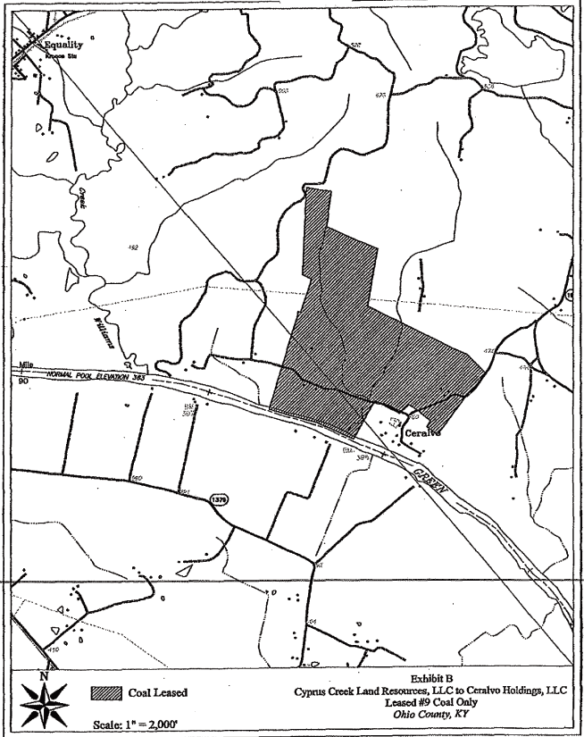
(a) The Ohio County Underground #9 Coal Area of the owned Kentucky #9 seam of coal only comprised
of approximately 18,153.5 entire interest acres and 673.5 partial interest acres, for a total of
approximately 18, 827 owned #9 coal acres, and all of the #9 coal mining rights and privileges
appurtenant thereto, in, on, and underlying the owned entire interest and partial interest #9 coal
only tracts, more particularly described on the attached
Exhibit A-1 and depicted on the map
attached hereto as Exhibit A-2; and
(b) The Elk Creek Surface Area comprised of approximately 415 acres of owned surface, and the
surface and coal mining rights and privileges appurtenant thereto, more particularly described on
the attached Exhibit B-1 and depicted on the map attached hereto as B-2;
all of the aforesaid Exhibits are incorporated herein by reference and made a part hereof, together
with all appurtenants thereunto belonging or in anywise appertaining, and being subject to the
known exceptions and prior conveyances more particularly set forth herein.
BEING the same property acquired by Ceralvo Holdings, LLC from Cyprus Creek Land Resources, LLC and
Cyprus Creek Land Company by Deed dated March 31, 2008, of record in Deed Book 373, Page 262, in
the office of the Clerk of Ohio County, Kentucky.
EXHIBIT A-1
No. 9 Vein of Coal and No. 9 Coal Mining Rights Only
| Item | Orig. L.C. No. | Acreage | ||
1.
|
028 - 296 | 220.09 acres |
AND BEING the same property conveyed to Peabody Coal Company by Big Rivers Electric Corporation by
deed dated May 13, 1988, recorded in Deed Book 265, page 418, in the Ohio County
Clerk’s office.
2.
|
028 - 033, T.23 | 258 acres | ||
| (except portion conveyed at Deed Book 237, page 80) |
AND BEING a portion of the property conveyed to Beaver Dam Coal Company and Rough River Coal
Company by Deed from W. G. Parrott, et ux., dated December 17,
1946, recorded in Deed Book 103,
page 394, in the Ohio County Clerk’s office. Rough River Coal Company conveyed its undivided
1/2 interest in Tracts No. 028 - 033 to The Alston Coal Company by deed dated November
21, 1947, recorded in Deed Book 105, page 621; and The Alston Coal Company conveyed its
undivided 1/2 interest in Tracts No. 028 - 033 to Sentry Royalty Company by deed
dated December 1, 1956, recorded in Deed Book 154, page 573; of record in the Ohio County Clerk’s
office.
3.
|
028 - 122 | 168 acres | ||
| (except portion conveyed at Deed Book 237, page 80) |
AND BEING a portion of the property conveyed to Sentry Royalty Company and Beaver Dam Coal Company
by Raymond T. Nall, widower, by deed dated February 14, 1961, recorded in Deed Book 178, page 18;
and also being the same property in which Peabody Coal Company conveyed its undivided 1/2
interest to Beaver Dam Coal Company, expressly reserving all underlying coal, by deed dated
December 27, 1974, recorded in Deed Book 210, page 657, both, in the Ohio County Clerk’s office.
4.
|
028 - 252 | 0.55 acres |
AND BEING the same property conveyed to Peabody Coal Company by Edwin Brown, et ux, by deed dated
June 8, 1977, recorded in Deed Book 224, page 227, in the Ohio County Clerk’s office.
5.
|
028 - 251 | 1.25 acres |
AND BEING
the same property conveyed to Peabody Coal Company by Earl Powers, et ux, by deed dated
June 8, 1977, recorded in Deed Book 224, page 229, in the Ohio County Clerk’s office.
8
6.
|
028 - 033, T.12, P.1 | 135.25 acres | ||
| (except portion conveyed at Deed Book 237, page 80) | ||||
7.
|
028 - 033, T.6, P.2 | 84.875 acres | ||
8.
|
028 - 033, T.2, P.2 | 72.5 acres | ||
9.
|
028 - 033, T.45 | 22 acres | ||
10.
|
028 - 033, T.1, P.2 | 58.5 acres | ||
11.
|
028 - 033, T.25 | 41.50 acres 50% Interest | ||
12.
|
028 - 033, T.15 | 42 acres | ||
13.
|
028 - 033, T.47 | 75 acres |
AND BEING a portion of the property conveyed to Beaver Dam Coal Company and Rough River Coal
Company by Deed from W. G. Parrott, et ux., dated December 17, 1946, recorded in Deed Book 103,
page 394, in the Ohio County Clerk’s office. Rough River Coal Company conveyed its undivided
1/2 interest in Tracts No. 028 - 033 to The Alston Coal Company by deed dated November
21, 1947, recorded in Deed Book 105, page 621; and The Alston Coal Company conveyed its undivided
1/2 interest in Tracts No. 028 - 033 to Sentry Royalty Company by deed dated December
1, 1956, recorded in Deed Book 154, page 573; of record in the Ohio County Clerk’s office.
14.
|
028 - C - 107 | 67 acres |
AND BEING
a portion of the property conveyed to Beaver Dam Coal Company by
Hattie B. Speed, et al.,
by deed dated March 15, 1916, recorded in Deed Book 51, page
135, in the Ohio County Clerk’s
office.
15.
|
028 - 194 | 5 acres |
AND BEING the same property conveyed to Peabody Coal Company and Beaver Dam Coal Company by
J. William Bassett, Trustee, by deed dated March 2, 1971, recorded in Deed Book 192,
page 387, in the Ohio County Clerk’s office.
16.
|
028 - C - 41 | 25 Less 5 acres |
AND BEING
a portion of the property conveyed to Beaver Dam Coal Company by
Hattie B. Speed, et al.,
by deed dated March 15, 1916, recorded in Deed Book 51, page 135, in the Ohio County
Clerk’s office.
17.
|
028 - 234 | 3 Less 0.25 acres |
AND BEING the same property conveyed to Peabody Coal Company by M. J. Boling, et ux.,
by deed dated December 2, 1974, recorded in Deed Book 210, page 311, in the Ohio County Clerk’s
office.
18.
|
028 - O - 7 | 10 acres |
AND BEING the same property conveyed to The Ohio County Land & Mining Company, a Kentucky
corporation, by J. P. Tichenor, et ux., by deed dated February 24, 1910,
recorded in Deed Book 38, page 416, in the Ohio County Clerk’s
office. Beaver Dam Coal Company became the owner of all of the stock, mineral tracts, and property of the Ohio County Land &
Mining Company, which was composed of the same shareholders as the Beaver Dam Coal Company.
9
19.
|
028 - C - 75 | 100 acres Less 3 acres, and Less 10 acres |
AND BEING a portion of the property conveyed to Beaver Dam Coal Company by Hattie B.
Speed, et al., by deed dated March 15, 1916, recorded in Deed Book 51, page 135, in the Ohio
County Clerk’s office.
20. |
028 - 033, T.14, P.1 | 34.80 acres | ||
| 028 - 033, T.14, P.2 | 66.15 acres | |||
21. |
028 - 033, T.1, P.1 | 95 acres | ||
22. |
028 - 033, T.7, P.1 | 100 acres |
AND BEING a portion of the property conveyed to Beaver Dam Coal Company and Rough River Coal
Company by deed from W. G. Parrott, et ux., dated December 17, 1946, recorded in Deed Book 103, page
394, in the Ohio County Clerk’s office. Rough River Coal Company conveyed its undivided 1/2
interest in Tracts No. 028 - 033 to The Alston Coal Company by deed dated November 21, 1947,
recorded in Deed Book 105, page 621; and The Alston Coal Company conveyed its undivided 1/2
Interest in Tracts No. 028 - 033 to Sentry Royalty Company by deed dated December 1, 1956,
recorded in Deed Book 154, page 573; of record in the Ohio County Clerk’s office.
23.
|
028 - C - 68 | 26.5 acres | ||
24.
|
028 - C - 69 | 100 acres |
AND BEING
a portion of the property conveyed to Beaver Dam Coal Company by Hattie B. Speed, et al.,
by deed dated March 15, 1916, recorded in Deed Book 51, page 135, in the Ohio County Clerk’s
office.
25. |
028 - 033, T.2, P.3 | 82.5 acres | ||
26. |
028 - 033, T.9 | 83.88 acres | ||
27. |
028 - 033, T.5, P.1 | 125 acres | ||
28. |
028 - 033, T.27 | 6.25 acres | ||
29. |
028 - 033, T.5, P.1 | 25 acres |
AND BEING a portion of the property conveyed to Beaver Dam Coal Company and Rough River Coal
Company by eed from W. G. Parrott, et ux., dated December 17, 1946, recorded
in Deed Book 103, page 394, in the Ohio County Clerk’s office. Rough River Coal Company conveyed
its undivided 1/2 interest in Tracts No. 028 - 033 to The Alston Coal Company by deed
dated November 21, 1947, recorded in Deed Book 105, page 621; and The Alston Coal Company conveyed
its undivided 1/2 interest in Tracts No. 028 - 033 to Sentry Royalty Company by deed
dated December 1, 1956, recorded in Deed Book 154, page 573; of record in the Ohio County Clerk’s
office.
30.
|
028 - C - 133 | 35 acres | ||
31.
|
028 - C - 134 | 15 acres |
AND BEING
a portion of the property conveyed to Beaver Dam Coal Company by Hattie B. Speed, et al.,
by deed dated March 15, 1916, recorded in Deed Book 51, page
135, in the Ohio County Clerk’s office.
32.
|
028 - 033, T.29, P.4 | 262 acres except cemetery | ||
33.
|
028 - 033, T.29, P.5 | 101.25 acres |
10
| (except portion conveyed at Deed Book 237, page 80) | ||||
34.
|
028 - 033, T.32, P.3 | 25 acres Undivided 1/2 Interest | ||
| (except portion conveyed at Deed Book 237, page 80) | ||||
35.
|
028 - 033, T.18, P.1 | 240 acres | ||
| (except portion conveyed at Deed Book 237, page 80) | ||||
36.
|
028 - 033, T.16 | 100 acres | ||
| (except portion conveyed at Deed Book 237, page 80) | ||||
37.
|
028 - 033, T.17 | 55 acres | ||
| (except portion conveyed at Deed Book 237, page 80) | ||||
38.
|
028 - 033, T.28, P.1 | 41 acres | ||
| (except portion conveyed at Deed Book 237, page 80) |
AND BEING a portion of the property conveyed to Beaver Dam Coal Company and Rough River Coal
Company by deed from W. G. Parrott, et ux., dated December 17, 1946, recorded in Deed
Book 103, page 394, in the Ohio County Clerk’s office. Rough River Coal Company conveyed its
undivided 1/2 interest in Tracts No. 028 - 033 to The Alston Coal Company by deed dated
November 21, 1947, recorded in Deed Book 105, page 621; and The Alston Coal Company conveyed its
undivided 1/2 interest in Tracts No. 028 - 033 to Sentry Royalty Company by deed dated
December 1, 1956, recorded in Deed Book 154, page 573; of record in the Ohio County Clerk’s office.
39.
|
028 - C - 35 | 679 acres |
AND BEING a portion of the property conveyed to Beaver Dam Coal Company by Hattie B. Speed, et al.,
by deed dated March 15, 1916, recorded in Deed Book 51, page 135, in the Ohio County Clerk’s
office.
40.
|
028 - 033, T.29, P.6 | 9.58 acres |
AND BEING a portion of the property conveyed to Beaver Dam Coal Company and Rough River Coal
Company by Deed from W. G. Parrott, et ux., dated December 17, 1946, recorded
in Deed Book 103, page 394, in the Ohio County Clerk’s office. Rough River Coal Company conveyed
its undivided 1/2 interest in Tracts No. 028 - 033 to The Alston Coal Company by deed dated
November 21, 1947, recorded in Deed Book 105, page 621; and The Alston Coal Company conveyed its
undivided 1/2 interest in Tracts
No. 028 - 033 to Sentry Royalty Company by deed dated December 1, 1956, recorded in Deed Book 154,
page 573; of record in the Ohio County Clerk’s office.
41.
|
028 - C - 144 | 123.75 acres | ||
42.
|
028 - C - 72 | 109 acres |
AND BEING a portion of the property conveyed to Beaver Dam Coal Company by Hattie B. Speed, et al.,
by deed dated March 15, 1916, recorded in Deed Book 51, page 135, in the Ohio County Clerk’s
office.
43.
|
028 - 033, T.61 | 53 acres |
AND BEING a portion of the property conveyed to Beaver Dam Coal Company and Rough River
Coal Company by deed from W. G. Parrott, et ux., dated
December 17, 1946, recorded in Deed Book 103,
page 394, in the Ohio County Clerk’s office. Rough River Coal
Company conveyed its undivided 1/2
interest in Tracts No. 028 - 033 to The Alston Coal Company by deed dated November 21, 1947,
recorded in Deed Book 105, page 621; and The Alston Coal
11
Company
conveyed its undivided 1/2 interest in Tracts No. 028 - 033 to Sentry Royalty
Company by deed dated December 1, 1956, recorded in Deed Book 154, page 573; of record in the Ohio
County Clerk’s office.
44.
|
028 - C - 36 | 133 acres | ||
45.
|
028 - C - 74 | 16 acres | ||
46.
|
028 - C - 45 | 36 acres | ||
47.
|
028 - C - 65 | 80 acres |
AND BEING a portion of the property conveyed to Beaver Dam Coal Company by Hattie B. Speed, et al.,
by deed dated March 15, 1916, recorded in Deed Book 51, page 135, in the Ohio County Clerk’s
office.
48.
|
028 - 033, T.32, P.2 | 5 acres |
AND BEING a portion of the property conveyed to Beaver Dam Coal Company and Rough River Coal
Company by deed from W. G. Parrott, et ux., dated December 17,
1946, recorded in Deed Book 103, page 394, in the Ohio County Clerk’s office. Rough River Coal
Company conveyed its undivided 1/2 interest in Tracts No. 028 - 033 to The Alston Coal
Company by deed dated November 21, 1947, recorded in Deed Book 105, page 621; and The
Alston Coal Company conveyed its undivided 1/2 interest in Tracts No. 028 - 033 to
Sentry Royalty Company by deed dated December 1, 1956, recorded in Deed Book 154, page 573; of
record in the Ohio County Clerk’s office.
49.
|
028 - C - 73 | 50 acres |
AND BEING
a portion of the property conveyed to Beaver Dam Coal Company by Hattie B. Speed, et al.,
by deed dated March 15, 1916, recorded in Deed Book 51, page 135, in the Ohio County Clerk’s
office.
50.
|
028 - 033, T.32, P.1 | 60 acres | ||
51.
|
028 - 033, T.31, P.2 | 124.50 acres |
AND BEING a portion of the property conveyed to Beaver Dam Coal Company and Rough River Coal
Company by deed from W. G. Parrott, et ux., dated December 17, 1946, recorded
in Deed Book 103, page 394, in the Ohio County Clerk’s office. Rough River Coal Company conveyed
its undivided 1/2 interest in Tracts No. 028 - 033 to The Alston Coal Company by deed
dated November 21, 1947, recorded in Deed Book 105, page 621; and The Alston Coal Company conveyed
its undivided 1/2 interest in Tracts No. 028 - 033 to Sentry Royalty Company by deed dated December
1, 1956, recorded in Deed Book 154, page 573; of record in the Ohio County Clerk’s office.
52.
|
028 - C - 127 | 30 acres | ||
53.
|
028 - C - 128 | 29 acres | ||
54.
|
028 - C - 126 | 60 acres |
AND BEING
a portion of the property conveyed to Beaver Dam Coal Company by Hattie B. Speed, et al.,
by deed dated March 15, 1916, recorded in Deed Book 51, page
135, in the Ohio County
Clerk’s office.
55.
|
028 - 033, T.42 | 71.5 acres |
12
AND BEING a portion of the property conveyed to Beaver Dam Coal Company and Rough River
Coal Company by deed from W. G. Parrott, et ux., dated December
17, 1946, recorded in Deed Book 103, page 394, in the Ohio County Clerk’s office. Rough River Coal
Company conveyed its undivided 1/2 interest in Tracts No. 028 - 033 to The Alston Coal
Company by deed dated November 21, 1947, recorded in Deed Book 105, page 621; and The Alston Coal
Company conveyed its undivided 1/2 interest in Tracts No. 028 - 033 to Sentry Royalty
Company by deed dated December 1, 1956, recorded in Deed Book 154, page 573; of record in the Ohio
County Clerk’s office.
56.
|
028 - C - 34 | 22.5 acres | ||
57.
|
028 - C - 113 | 230 acres Less 1 acre Cemetery | ||
58.
|
028 - C - 63 | 62.5 acres | ||
59.
|
028 - C - 64 | 25 acres |
AND BEING a portion of the property conveyed to Beaver Dam Coal Company by Hattie B. Speed, et al.,
by deed dated March 15, 1916, recorded in Deed Book 51, page 135, in the Ohio County Clerk’s
office.
60.
|
028 - 033, T.54 | 110.5 acres |
AND BEING a portion of the property conveyed to Beaver Dam Coal Company and Rough River Coal
Company by deed from W. G. Parrott, et ux., dated December 17, 1946, recorded
in Deed Book 103, page 394, in the Ohio County Clerk’s office. Rough River Coal Company conveyed
its undivided 1/2 interest in Tracts No. 028 - 033 to The Alston Coal Company by deed
dated November 21, 1947, recorded in Deed Book 105, page 621; and The Alston Coal Company conveyed
its undivided 1/2 interest in Tracts No. 028 - 033 to Sentry Royalty Company by deed
dated December 1, 1956, recorded in Deed Book 154, page 573; of record in the Ohio County Clerk’s
office.
61.
|
028 - C - 60 | 80 Less 20 acres, and Less 15 acres | ||
62.
|
028 - C - 61 | 40.25 acres | ||
63.
|
028 - C - 70 | 36 acres | ||
64.
|
028 - C - 66 | 90.5 acres |
AND BEING
a portion of the property conveyed to Beaver Dam Coal Company by Hattie B.
Speed, et al., by deed dated March 15, 1916, recorded in Deed Book 51, page 135, in the Ohio
County Clerk’s office.
65.
|
028 - 033, T.13 | 102.45 acres | ||
66.
|
028 - 033, T.49, P.1 | 81 acres |
AND BEING a portion of the property conveyed to Beaver Dam Coal Company and Rough River Coal
Company by deed from W. G. Parrott, et ux., dated December 17, 1946,
recorded in Deed Book 103, page 394, in the Ohio County Clerk’s office. Rough River Coal Company
conveyed its undivided 1/2 interest in Tracts No. 028 - 033 to The Alston Coal Company
by deed dated November 21, 1947, recorded in Deed Book 105, page 621; and The Alston
Coal Company conveyed its undivided 1/2 interest in Tracts No. 028 - 033 to Sentry
Royalty Company by deed dated December 1, 1956, recorded in Deed Book 154, page 573; of record in
the Ohio County Clerk’s office.
67.
|
028 - C - 67 | 31 acres |
13
AND BEING
a portion of the property conveyed to Beaver Dam Coal Company by Hattie B. Speed, et al.,
by deed dated March 15, 1916, recorded in Deed Book 51, page 135, in the Ohio County Clerk’s
office.
68.
|
028 - 033, T.43 | 25 acres |
AND BEING a portion of the property conveyed to Beaver Dam Coal Company and Rough River Coal
Company by deed from W. G. Parrott, et ux., dated December 17, 1946, recorded in Deed
Book 103, page 394, in the Ohio County Clerk’s office. Rough River Coal Company conveyed its
undivided 1/2 interest in Tracts No. 028 - 033 to The Alston Coal Company by deed dated November
21, 1947. recorded in Deed Book 105, page 621; and The Alston. Coal Company conveyed its undivided
1/2 interest in Tracts No. 028 - 033 to Sentry Royalty Company by deed dated December 1, 1956,
recorded in Deed Book 154, page 573; of record in the Ohio County Clerk’s office.
69.
|
028 - C - 71 | 20 acres |
AND BEING a portion of the property conveyed to Beaver Dam Coal Company by Hattie B. Speed, et al.,
by deed dated March 15, 1916, recorded in Deed Book 51, page 135, in the Ohio County Clerk’s
office. Also being a portion of the property in which Beaver Dam Coal Company conveyed all coal
above the # 9 seam of coal to Blue Diamond Mining Company by deed dated November 15,
1921, recorded in Deed Book 62, page 381, in the Office of the Ohio County Clerk.
70.
|
028 - E - 81 | 13.5 Less 0.07 Acres |
AND BEING the same property conveyed to Beaver Dam Coal Company by Robert Snodgrass, et ux.,
by deed dated December 18, 1974, recorded in Deed Book 210, page 654, in the Ohio County
Clerk’s office.
71.
|
028 - C - 123 | 69.5 acres | ||
72.
|
028 - C - 122 | 50 acres | ||
73.
|
028 - C - 111 | 42 acres and 74 poles. |
AND BEING
a portion of the property conveyed to Beaver Dam Coal Company by Hattie B. Speed, et al.,
by deed dated March 15, 1916, recorded in Deed Book 51, page
135, in the Ohio County Clerk’s
office. Also being a portion of the property in which Beaver Dam Coal Company conveyed all coal
above the # 9 seam of coal to Blue Diamond Mining Company by deed
dated November 15, 1921,
recorded in Deed Book 62, page 381, in the Ohio County Clerk’s Office.
74.
|
028 - 195 | 42 acres and 74 poles |
AND BEING the same property conveyed to Peabody Coal Company and Beaver Dam Coal Company
by J. William Bassett, Trustee, by deed dated March 12, 1971, recorded in Deed Book
192, page 385, in the Ohio County Clerk’s office.
75.
|
038 - 121 | 42 acres and 74 poles |
AND BEING the same property conveyed to Peabody Coal Company by Robert Snodgrass, et ux.,
by deed dated February 26, 1979, recorded in Deed Book 231, page 661, in the Ohio County
Clerk’s office.
14
76.
|
028 - C - 112 | 42 acres and 74 poles | ||
77.
|
028 - C - 108 | 15 acres | ||
78.
|
028 - C - 110 | 43 acres and 77 poles, except 2.5 acres | ||
79.
|
028 - C - 109 | 42 acres |
AND BEING a portion of the property conveyed to Beaver Dam Coal Company by Hattie B. Speed, et al.,
by deed dated March 15, 1916, recorded in Deed Book 51, page 135, in the Ohio County Clerk’s office.
80.
|
028 - D - 87 | 156.875 acres Except 1 acre cemetery | ||
81.
|
028 - D - 82 | 138.50 acres | ||
82.
|
028 - D - 84 | 55 acres | ||
| 38/40 Interest; and 2/40 Interest Adversely Possessed | ||||
83.
|
028 - D - 19 | 33.33 acres | ||
84.
|
028 - D - 81 | 61.50 acres |
AND BEING a portion of the property conveyed to Beaver Dam Coal Company by I. P. Barnard,
et ux., by deed dated March 15, 1916, recorded in Deed Book 51, page 101, in the Ohio County Clerk’s
office.
85.
|
028 - 250(2), P.2 | LEASEHOLD RESERVED HEREIN | ||
86.
|
028 - D - 50 | 31 acres |
AND BEING a portion of the property conveyed to Beaver Dam Coal Company by I. P. Barnard, et ux., by
deed dated March 15, 1916, recorded in Deed Book 51, page 101, in the Ohio County
Clerk’s office.
87.
|
028 - 202 | 17 acres | Undivided 2/7 Interest | |||
| 028 - 220 | 17 acres | Undivided 5/7 Interest |
AND BEING
the same property from which Katie Ball, widow, et al., conveyed an undivided 2/7
interest to Peabody Coal Company by deed dated January 28, 1972, recorded in Deed Book 197,
page 345; and from which Ernest Duncan, et ux., conveyed an undivided 5/7 interest to
Peabody Coal Company by deed dated December 7, 1972, recorded in Deed Book 216, page 604; both in
the Ohio County Clerk’s office.
88.
|
028 - D - 56 | 50 acres | ||
89.
|
028 - D - 80 | 38 acres | ||
90.
|
028 - D - 49 | 38 acres | ||
91.
|
028 - D - 48 | 77 acres and 23 poles |
AND BEING a portion of the property conveyed to Beaver Dam Coal Company by I. P. Barnard, et ux.,
by deed dated March 15, 1916, recorded in Deed Book 51, page 101, in the Ohio County Clerk’s office.
92.
|
028 - C - 1 | 92 acres |
AND BEING a portion of the property conveyed to Beaver Dam Coal Company by Hattie B.
Speed, et al., by deed dated March 15, 1916, recorded in Deed Book 51, page 135, in the Ohio County
Clerk’s office.
15
93.
|
028 - 250(2), P.1, T.2 and T.3 | LEASEHOLD RESERVED HEREIN | ||
94.
|
028 - 250(2), P.1, T.1 | LEASEHOLD RESERVED HEREIN | ||
95.
|
028 - 250(2), P.1, T.4 | LEASEHOLD RESERVED HEREIN | ||
96.
|
028 - 250(2), P .1, T.5 and T.6 | LEASEHOLD RESERVED HEREIN |
97.
|
028 - C - 62 | 139 acres |
AND BEING a portion of the property conveyed to Beaver Dam Coal Company by Hattie B. Speed, et al.,
by deed dated March 15, 1916, recorded in Deed Book 51, page 135, in the Ohio County Clerk’s
office.
98.
|
028 - 185, P.5 | 279 acres |
AND BEING the same property conveyed to Peabody Coal Company by BB Mining Company by deed dated
August 24, 1970, recorded in Deed Book 191, page 280, in the Ohio County Clerk’s
office.
99.
|
028 - 137, T.1 | 75 acres | ||
| 028 - 137, T.2 | 56 acres | |||
| 028 - 137, T.3, P.1 | 64.75 acres | |||
| 028 - 137, T.3, P.2 | 76 acres | |||
| 028 - 137, T.4, P.1 | 29.25 acres | |||
| 028 - 137, T.4, P.2 | 27.20 acres | |||
| 028 - 137, T.5 | 75 acres | |||
| 028 - 137, T.6 | 64 acres |
AND BEING the same property conveyed to Beaver Dam Coal Company and Sentry Royalty
Company by Deed from Grace Addington, et al., dated November 7, 1964, recorded in Deed Book 163,
page 241, in the Ohio County Clerk’s office.
100.
|
028 - C - 129 | 20 acres and 62 poles | ||
101.
|
028 - C - 16 | 56 acres | ||
102.
|
028 - C - 43 | 25 acres |
AND BEING a portion of the property conveyed to Beaver Dam Coal Company from Hattie B. Speed, et
al., by deed dated March 15, 1916, recorded in Deed Book 51, page 135, in the Ohio County Clerk’s
office.
103.
|
028 - O - 6 | 15 acres |
AND BEING the same property conveyed to The Ohio County Land & Mining Company, a Kentucky
corporation, by Louis Brown, et ux., by deed dated September 21, 1907, recorded in Deed Book 85,
page 314, in the Ohio County Clerk’s office. Beaver Dam Coal Company became the owner of all of the
stock, mineral tracts, and property of the Ohio County Land & Mining Company, which was composed of
the same shareholders as the Beaver Dam Coal Company.
104.
|
028 - 033, T.41 | 25 acres also known as 028 - 092, T.4 | ||
| 028 - 092, T.4 | 25 acres also known as 028 - 033, T.41 |
16
AND BEING a portion of Tracts No. 028 - 033 conveyed to Beaver Dam Coal Company and Rough
River Coal Company by Deed from W. G. Parrott, et ux., dated December 17, 1946, recorded in Deed
Book 103, page 394, in the Ohio County Clerk’s office. Rough River Coal Company conveyed its
undivided 1/2 interest in Tracts No. 028 - 033 to The Alston Coal Company by deed dated November
21, 1947, recorded in Deed Book 105, page 621; and The Alston Coal Company conveyed its undivided
1/2 interest in Tracts No. 028 - 033 to Sentry Royalty Company by deed dated December 1, 1956,
recorded in Deed Book 154, page 573; of record in the Ohio County Clerk’s office.
FURTHER BEING a portion of Tracts No. 028 - 092 conveyed to Beaver Dam Coal Company and Sentry
Royalty Company from Gertrude Igleheart, widow, et al., by deed dated December 24, 1957, recorded
in Deed Book 135, page 400; and by deed of correction dated January 3, 1959, recorded in Deed Book
139, page 338, in the Ohio County Clerk’s office.
105.
|
028 - C - 38 | 23 acres | ||
106.
|
028 - C - 22 | 28.375 acres |
AND BEING a portion of the property conveyed to Beaver Dam Coal Company from Hattie B. Speed, et
al., by deed dated March 15, 1916, recorded in Deed Book 51, page 135, in the Ohio County Clerk’s
office.
107.
|
028 - 033, T.31, P.1 | 39.5 acres | ||
108.
|
028 - 033, T.30 | 2.2 acres |
AND BEING a portion of the property conveyed to Beaver Dam Coal Company and Rough River Coal
Company by Deed from W. G. Parrott, et ux., dated December 17, 1946, recorded in Deed
Book 103, page 394, in the Ohio County Clerk’s office. Rough River Coal Company conveyed its
undivided 1/2 interest in Tracts No. 028 - 033 to The Alston Coal Company by deed dated November
21, 1947, recorded in Deed Book 105, page 621; and The Alston Coal Company conveyed its undivided
1/2 interest in Tracts No. 028 - 033 to Sentry Royalty Company by deed dated December 1, 1956,
recorded in Deed Book 154, page 573; of record in the Ohio County Clerk’s office.
109.
|
028 - C - 40 | 18 acres | ||
110.
|
028 - C - 37 | 63 Less 6 acres | ||
111.
|
028 - C - 29 | 100.25 acres | ||
112.
|
028 - C - 31 | 27 acres | ||
113.
|
028 - C - 30 | 130 acres | ||
114.
|
028 - C - 28 | 60 acres | ||
115.
|
028 - C - 33 | 2.5 acres | ||
116.
|
028 - C - 32 | 40 acres | ||
117.
|
028 - C - 21 | 68.75 acres | ||
118.
|
028 - C - 20 | 133 Less 68.75 acres | ||
119.
|
028 - C - 18 | 50 acres Except 0.75 acre school lot | ||
120.
|
028 - C - 19 | 26.80 acres |
AND BEING a portion of the property conveyed to Beaver Dam Coal Company from Hattie B. Speed, et
al., by deed dated March 15, 1916, recorded in Deed Book 51, page 135, in the Ohio County Clerk’s
office.
121.
|
028 - 111, P.1, T.1 | 1 acre |
17
AND BEING the same property conveyed to Sentry Royalty Company and Beaver Dam Coal Company
from Ray Ward, et ux., by deed dated July 25, 1960, recorded in Deed Book 145, page 479, in the
Ohio County Clerk’s office.
| 122. | 028 - 092, T.1 | 15.75 acres | ||
| 028 - 092, T.2 | 53 acres | |||
| 028 - 092, T.3 | 68 acres |
AND BEING a portion of the property conveyed to Beaver Dam Coal Company and Sentry Royalty
Company from Gertrude Igleheart, widow, et al., by deed dated December 24, 1957, recorded in Deed
Book 135, page 400; and by deed of correction dated January 3,
1959, recorded in Deed Book 139,
page 338, in the Ohio County Clerk’s office.
| 123. | 028 - C - 39 | 65 acres | ||
| 124. | 028 - C - 17 | 80 acres | ||
| 125. | 028 - C - 50 | 80 acres | ||
| 126. | 028 - C - 10 | 64.75 acres | ||
| 127. | 028 - C - 27 | 59 acres | ||
| 128. | 028 - C - 26 | 40 acres | ||
| 129. | 028 - C - 114 | 51 acres | ||
| 130. | 028 - C - 115 | 182 Less 51 acres | ||
| 131. | 028 - C - 11 | 156 Less 7 acres | ||
| 132. | 028 - C - 23 | 7 acres | ||
| 133. | 028 - C - 24 | 1 acre | ||
| 134. | 028 - C - 125 | 156.25 acres | ||
| 135. | 028 - C - 44 | 10 acres | ||
| 136. | 028 - C - 42 | 70 acres |
AND BEING
a portion of the property conveyed to Beaver Dam Coal Company from Hattie B. Speed, et
al., by deed dated March 15, 1916, recorded in Deed Book 51, page 135, in the Ohio County Clerk’s
office.
| 137. | 028 - 095 | 26.875 acres |
AND BEING the same property conveyed to Beaver Dam Coal Company and Sentry Royalty Company from
John W. Fulkerson, single, by deed dated December 30, 1957, recorded in Deed Book 135, page 445,
in the Ohio County Clerk’s office.
| 138. | 028 - 091 | 67.1 acres |
AND BEING the same property conveyed to Beaver Dam Coal Company and Sentry Royalty Company from
Elmer L. Fulkerson, et ux., by deed dated December 23, 1957, recorded in Deed Book 135, page 391,
in the Ohio County Clerk’s office.
| 139. | 028 - 094 | 67.1 acres |
AND BEING the same property conveyed to Beaver Dam Coal Company and Sentry Royalty Company from
O. D. Fulkerson, et ux., by deed dated December 24, 1957, recorded in Deed Book 135, page 406, in
the Ohio County Clerk’s office.
| 140. | 028 - 093, T.1 | 129.25 acres |
18
AND BEING the same property conveyed to Beaver Dam Coal Company and Sentry Royalty Company in the
following deeds of record in the Ohio County Clerk’s office:
| (a) | Gertrude Igleheart, widow, by deed dated December 24, 1957, recorded in Deed Book 135, page 397; | |
| (b) | Leslie K. Grimes, et ux., by deed dated January 2, 1958, recorded in Deed Book 135, page 504; | |
| (c) | Charles M. Grimes, et ux., by deed dated January 13, 1958, recorded in Deed Book 135, page 523; ‘ | |
| (d) | Mayme Jane Grimes Holland, et vir., by deed dated January 15, 1958, recorded in Deed Book 135, page 572; | |
| (e) | David E. Grimes, et ux., by deed dated January 21, 1958, recorded in Deed Book 135, page 587. |
| 141. | 028 - 185, P.4 | 151.875 acres |
AND BEING
the same property conveyed to Peabody Coal Company from BB Mining Company by deed dated
August 24, 1970, recorded in Deed Book 191, page 280, in the Ohio County Clerk’s office.
| 142. | 028 - 126, T.1 | 35 acres | ||
| 028 - 126, T.2 | 3 acres | |||
| 028 - 126, T.3 | 148 acres | |||
| 028 - 126, T.4 | 71.5 acres |
AND BEING the same tracts conveyed to Beaver Dam Coal Company and Sentry Royalty Company from
Ross Morton, et ux., by deed dated January 20, 1962, recorded in Deed Book 151, page 180, in the
Ohio County Clerk’s office.
| 143. | 028 - D - 38 | 73 acres |
||
| 144. | 028 - D - 63 | 54 Less 2 acres and 100% Interest |
||
2-acre portion of 54 acres 80% Interest |
||||
| 145. | 028 - D - 22 | 53.33 acres |
||
| 146. | 028 - D - 39 | 52.50 acres |
||
| 028 - D - 40 | 52 acres |
|||
| 147. | 028 - D - 40A | 3.50 acres |
||
| 148. | 028 - D - 53 | 40 acres |
||
| 149. | 028 - D - 47 | 83 acres |
AND BEING a portion of the property conveyed to Beaver Dam Coal Company from I. P. Barnard, et
ux., by deed dated March 15, 1916, recorded in Deed Book 51, page 101, in the Ohio County Clerk’s
office.
| 150. | 028 - C - 151 | 106 acres and 69.25 poles |
AND BEING a portion of the property conveyed to Beaver Dam Coal Company from Hattie B. Speed, et
al., by deed dated March 15, 1916, recorded in Deed Book 51, page 135, in the Ohio County Clerk’s
office.
| 151. | 1928 - 300 | 1.5 acres and 10.75 poles 50% Interest |
||
| 1928 - 300 - 01 | 1.5 acres and 10.75 poles 40% Interest |
19
AND BEING the same property from which an undivided 1/2 interest was conveyed from Morgan
Duncan, et ux., to Peabody Development Company, LLC, by deed dated February 1, 2005, recorded in
Deed Book 353, page 38; and from which an undivided 2/5 interest was conveyed from Joseph S.
Allen, et ux., to Peabody Development Company, LLC, by deed dated February 10, 2005, recorded in
Deed Book 353, page 42; both In the Ohio County Clerk’s office.
| 152. | 1928 - 302 | 7 acres | 60% Interest |
AND BEING the same property conveyed to Peabody Development Company, LLC, in the Ohio County
Clerk’s office, as follows:
| (a) | Fanny M. Curtis by deed dated March 17, 2005, recorded in Deed Book 354, page 341; | |
| (b) | Lillian Finley Bassett by deed dated April 25, 2005, recorded in Deed Book 354, page 350; | |
| (c) | Hubert Ashby by deed dated April 18, 2005, recorded in Deed Book 354, page 358. |
| 153. | 028 - D - 78 | 141.50 acres Except 15 acres |
||
| 154. | 028 - D - 1 | 52.75 acres |
||
| 155. | 028 - D - 23 | 243.33 acres |
||
| 156. | 028 - D - 77 | 40 acres |
||
| 157. | 028 - D - 76 | 160 acres Except 6 acres and 20 poles |
AND BEING a portion of the property conveyed to Beaver Dam Coal Company from I. P. Barnard, et
ux., by deed dated March 15, 1916, recorded in Deed Book 51, page 101, in the Ohio County Clerk’s
office.
| 158. | 028 - C - 77 | 50 acres |
||
| 159. | 028 - C - 76 | 78 acres |
||
| 160. | 028 - C - 52 | 50 acres |
AND BEING a portion of the property conveyed to Beaver Dam Coal Company from Hattie B. Speed, et
al., by deed dated March 15, 1916, recorded in Deed Book 51, page 135, in the Ohio County Clerk’s
office.
| 161. | 028 - D - 42 | 60 Less 5 acres |
AND BEING a portion of the property conveyed to Beaver Dam Coal Company from I. P. Barnard, et
ux., by deed dated March 15, 1916, recorded in Deed Book 51, page 101, in the Ohio County Clerk’s
office.
| 162. | 028 - C - 53 | 5 acres |
||
| 163. | 028 - C - 54 | 137 acres |
AND BEING a portion of the property conveyed to Beaver Dam Coal Company from Hattie B. Speed, et
al., by deed dated March 15, 1916, recorded in Deed Book 51, page 135, in the Ohio County Clerk’s
office.
| 164. | 028 - D - 46 | 25 acres |
20
AND BEING
a portion of the property conveyed to Beaver Dam Coal Company from I. P. Barnard, et
ux., by deed dated March 15, 1916, recorded in Deed Book 51, page 101, in the Ohio County Clerk’s
office.
| 165. | 028 - C - 154 | 71 acres |
AND BEING a portion of the property conveyed to Beaver Dam Coal Company from Hattie B. Speed, et
al., by deed dated March 15, 1916, recorded in Deed Book 51, page 135, in the Ohio County Clerk’s
office.
| 166. | 028 - D - 37 | 23 acres |
AND BEING a portion of the property conveyed to Beaver Dam Coal Company from I. P. Barnard, et
ux., by deed dated March 15, 1916, recorded in Deed Book 51, page 101, in the Ohio County Clerk’s
office.
| 167. | 028 - C - 55 | 60 acres |
AND BEING a portion of the property conveyed to Beaver Dam Coal Company from Hattie B. Speed, et
al., by deed dated March 15, 1916, recorded in Deed Book 51, page 135, in the Ohio County Clerk’s
office.
| 168. | 028 - D - 79 | 102.50 acres and 22 poles |
AND BEING a portion of the property conveyed to Beaver Dam Coal Company from I. P. Barnard, et
ux., by deed dated March 15, 1916, recorded in Deed Book 51, page 101, in the Ohio County Clerk’s
office.
| 169. | 028 - 083, T.5 | 80 acres |
AND BEING a portion of the property conveyed to Beaver Dam Coal Company and Sentry Royalty Company
from Ross Morton, et ux., et al., by deed dated February 18, 1957, recorded in Deed Book 131, page
492, in the Ohio County Clerk’s office.
| 170. | 028 - C - 105 | 40 acres |
AND BEING a portion of the property conveyed to Beaver Dam Coal Company from Hattie B. Speed, et
al., by deed dated March 15, 1916, recorded in Deed Book 51, page 135, in the Ohio County Clerk’s
office.
| 171. | 028 - D - 65 | 57 acres |
AND BEING a portion of the property conveyed to Beaver Dam Coal Company from I. P. Barnard, et
ux., by deed dated March 15, 1916, recorded in Deed Book 51, page 101, in the Ohio County Clerk’s
office.
| 172. | 028 - 146 | 30 acres |
AND BEING the same tract conveyed to Beaver Dam Coal Company and Sentry Royalty Company from
Elzoria Stearman Bishop, et al., by Master Commissioner Deed dated April 14, 1966, recorded in
Commissioner’s Deed Book M, page 201, in the Ohio County Clerk’s office.
21
| 173. | 028 - 081, T.1 | 130 acres |
||
| 028 - 081, T.2 | 100 acres |
AND BEING the same tracts conveyed to Beaver Dam Coal Company and Sentry Royalty Company from R.
H. Morris, et ux., by deed dated February 13, 1957, recorded in Deed Book 131, page 351; in the
Ohio County Clerk’s office.
| 174. | 028 - C - 5 | 38 acres |
||
| 175. | 028 - C - 8 | 105 acres except 1 acre school lot |
AND BEING a portion of the property conveyed to Beaver Dam Coal Company from Hattie B. Speed, et
al., by deed dated March 15, 1916, recorded in Deed Book 51, page 135, in the Ohio County Clerk’s
office.
| 176. | 028 - 096 | 35 acres |
AND BEING the same property conveyed to Beaver Dam Coal Company and Sentry Royalty Company
from Ethel Morton, et al., by Master Commissioner Deed dated April 19, 1958, recorded in
Commissioner’s Deed Book L, page 391, in the Ohio County Clerk’s office.
| 177. | 028 - C - 6 | 40 acres |
||
| 178. | 028 - C - 7 | 10 acres |
||
| 179. | 028 - C - 155 | 90 acres |
||
| 180. | 028 - C - 58 | 55 acres |
||
| 181. | 028 - C - 118 | 80 acres |
||
| 182. | 028 - C - 13 | 86 acres |
||
| 183. | 028 - C - 15 | 85.75 acres |
||
| 184 | 028 - C - 14 | 2 acres |
||
| 185. | 028 - C - 12 | 100 Less 2 acres except cemetery |
||
| 186. | 028 - C - 131 | 100 acres |
||
| 187. | 028 - C - 132 | 69.5 Less 31.25 acres |
||
| 188. | 028 - C - 130 | 31.25 acres |
||
| 189. | 028 - C - 47 | 50.5 acres except 0.5 acre cemetery |
||
| 190. | 028 - C - 48 | 55 acres |
||
| 191. | 028 - C - 157 | 87.35 less 5 acres |
||
| 192. | 028 - C - 9 | 166 acres |
||
| 193. | 028 - C - 149 | 47.25 acres |
AND BEING a portion of the property conveyed to Beaver Dam Coal Company from Hattie B. Speed,
et al., by deed dated March 15, 1916, recorded in Deed Book 51, page 135, in the Ohio County
Clerk’s office.
| 194. | 1123 - 005, T.1, P.1 | 100 acres except portion of 47.5 acres |
||
| 1123 - 005, T.1, P.2 | 9 acres, 2 roods |
|||
& 38 poles except portion of 47.5 acres |
||||
| 1123 - 005, T.1, P.3 | 9 acres, 1 rood |
|||
& 23 poles except portion of 47.5 acres |
||||
| 1123 - 005, T.1, P.4 | 30 acres, 3 roods |
|||
& 19 poles except portion of 47.5 acres |
||||
| 1123 - 005, T.2 | 19 acres |
22
AND BEING the same property conveyed to Peabody Development Company, LLC, from Wallace L.
Loyd, et ux., et al. (heirs of O. J. Loyd) by deed dated October 14, 2004, recorded in Deed Book
351, page 240, in the Ohio County Clerk’s office.
| 195. | 028 - C - 159 | 45.40 acres |
||
| 196. | 028 - C - 158 | 65 acres |
AND BEING a portion of the property conveyed to Beaver Dam Coal Company from Hattie B. Speed, et
al., by deed dated March 15, 1916, recorded in Deed Book 51, page 135, in the Ohio County Clerk’s
office.
| 197. | 028 - 125, T.1 | 10.66 acres | 100% Interest |
|||
| 028 - 125, T.2 | 31.80 acres | Approx. 93.3% Interest |
||||
| 028 - 125, T.3 | 44.20 acres | Approx. 93.3% Interest |
AND BEING the same property conveyed to Beaver Dam Coal Company and Sentry Royalty Company by the
following deeds of record in the Ohio County Clerk’s office:
| (a) | Altha Addington Morton, widow, et al., by deed dated January 20, 1962, recorded in Deed Book 151, page 184; | |
| (b) | Orhal Smith, single, by deed dated March 9, 1965, recorded in Deed Book 164, page 415; | |
| (c) | Alice Addington, widow, et al., by deed dated March 24, 1965, recorded in Deed Book 164, page 591; | |
| (d) | Esther Addington, widow, et al., by deed dated March 13, 1965, recorded in Deed Book 165, page 641; and | |
| (e) | Esther Addington, widow, et al., by deed dated April 7, 1966, recorded in Deed Book 168, page 609. |
| 198. | 028 - C - 56 | 91 less 2 acres |
||
| 199. | 028 - C - 49 | 140 less 30 acres |
||
| 200. | 028 - C - 51 | 68 acres |
||
| 201. | 028 - C - 25 | 30 acres |
||
| 202. | 028 - C - 135 | 70 acres |
||
| 203. | 028 - C - 46 | 62.5 less 12 acres |
AND BEING
a portion of the property conveyed to Beaver Dam Coal Company from Hattie B. Speed, et
al., by deed dated March 15, 1916, recorded in Deed Book 51, page 135, in the Ohio County Clerk’s
office.
| 204. | 028 - 083, T.1 | 62.5 acres | 80% Interest |
|||
| 028 - 083, T.2 | 75 acres | 100% Interest |
||||
| 028 - 083, T.3 | 102 acres | 100% Interest |
||||
| 028 - 083, T.4 | 12 acres | 100% Interest |
AND BEING a portion of the property conveyed to Beaver Dam Coal Company and Sentry Royalty
Company from Ross Morton, et ux., et al., by deed dated February 18, 1957, recorded in Deed Book
131, page 492, in the Ohio County Clerk’s office.
| 205. | 028 - C - 136 | 15.25 less 2.50 acres |
||
| 206. | 028 - C - 137 | 1.75 acres |
||
| 207. | 028 - C - 138 | 16.50 acres |
||
| 208. | 028 - C - 119 | 4.40 acres |
23
| 209. | 028 - C - 140 | 17 acres |
||
| 210. | 028 - C - 139 | 0.75 acres |
AND BEING a portion of the property conveyed to Beaver Dam Coal Company from Hattie B. Speed,
et al., by deed dated March 15, 1916, recorded in Deed Book 51, page 135, in the Ohio County
Clerk’s office.
| 211. | 028 - 138 | 135.5 acres | Approx. 58.432% Interest |
AND BEING the same property conveyed to Beaver Dam Coal Company and Sentry Royalty Company by the
following deeds of record in the Ohio County Clerk’s office:
| (a) | Ida Hicks, et vir., by deed dated December 14, 1964, recorded in Deed Book 163, page 535; | |
| (b) | O. D. Fulkerson by deed dated December 18, 1964, recorded in Deed Book 163, page 577; | |
| (c) | Athel Danks, et vir., et al., by deed dated December 15, 1964, recorded in Deed Book 163, page 582; | |
| (d) | C. O. Hunter, et ux., by deed dated December 24, 1964, recorded in Deed Book 163, page 585; | |
| (e) | Willie E. Henry, et vir., by deed dated August 17, 1967, recorded in Deed Book 175, page 560; | |
| (f) | Austin C. Hunter, et ux., by deed dated September 19, 1967, recorded in Deed Book 176, page 235; | |
| (g) | Roy Hunter Trunnell, et ux., by deed dated March 25, 1968, recorded in Deed Book 178, page 527; | |
| (h) | Martha Barnard Hess, et vir., by deed dated April 10, 1968, recorded in Deed Book 179, page 37; and | |
| (i) | Ernest B. Trunnell, et ux., by deed dated February 3, 1976, recorded in Deed Book 217, page 313. |
| 212. | 028 - C - 120 | 57.50 acres | 100% Interest |
|||
| 213. | 028 - C - 121 | 40 acres | 100% Interest |
|||
| 214. | 028 - C - 59 | 88 acres | 50% Interest |
AND BEING a portion of the property conveyed to Beaver Dam Coal Company from Hattie B. Speed, et
al., by deed dated March 15, 1916, recorded in Deed Book 51, page 135, in the Ohio County Clerk’s
office.
| 215. | 028 - 147, T.1 | 40 acres |
AND BEING the same property conveyed to Peabody Coal Company and Beaver Dam Coal Company from
Pauline Johnson, et ux., by deed dated April 28, 1966, recorded in Deed Book 169, page 130; from
Fannie White, et ux., by deed dated September 20, 1968, recorded in Deed Book 181, page 63; and
from Ellen Bellew by deed dated October 1, 1968, recorded in Deed Book 181, page 155; all in the
Ohio County Clerk’s office.
| 216. | 028 - C - 57 | 115 acres |
AND BEING a portion of the property conveyed to Beaver Dam Coal Company from Hattie B. Speed, et
al., by deed dated March 15, 1916, recorded in Deed Book 51, page 135, in the Ohio County Clerk’s
office.
24
| 217. | 028 - 100, T.2 | 59 acres |
AND BEING the same property conveyed to Sentry Royalty Company and Beaver Dam Coal Company from
Icelean Bennett Young by deed dated May 12, 1959, recorded in Deed Book 141, page 115, in the Ohio
County Clerk’s office.
| 218. | 028 - 070 | 86.5 acres |
AND BEING the same property conveyed to Homestead Coal Company and Beaver Dam Coal Company from
Herbert Martin, et ux., by deed dated September 22, 1955, recorded in Deed Book 126, page 245, in
the Ohio County Clerk’s office.
| 219. | 028 - 053 | 175 Less 7 acres |
AND BEING the same property conveyed to Homestead Coal Company and Beaver Dam Coal Company from
O. E. Allen, et ux., by deed dated March 30, 1955, recorded in Deed Book 124, page 73; and from
Margaret Gill, et vir., et al., by deed dated May 23, 1955, recorded in Deed Book 124, page 443;
both in the Ohio County Clerk’s office.
| 220. | 028 - 069 | 145 acres |
AND BEING the same property conveyed to Homestead Coal Company and Beaver Dam Coal Company
from Mary Lee Drake, et vir., by deed dated September 22, 1955, recorded in Deed Book 126, page
213, in the Ohio County Clerk’s office.
| 221. | 028 - 100, T.1 | 30.75 acres |
AND BEING the same property conveyed from Icelean Bennett Young to Sentry Royalty Company and
Beaver Dam Coal Company by deed dated May 12, 1959, recorded in Deed Book 141, page 115, in the
Ohio County Clerk’s office.
| 222. | 028 - 102, T.1 | 12 acres |
||
| 028 - 102, T.2 | 37.5 acres |
AND BEING
the same property conveyed to Sentry Royalty Company and Beaver Dam Coal Company in the
following deeds, all in the Ohio County Clerk’s office:
| a) | Ed Bennett, et ux., dated September 15, 1959, recorded in Deed Book 142, page 512; | |
| b) | Stella Russell dated September 19, 1959, recorded in Deed Book 142, page 516; | |
| c) | Minnie Perry, et al., dated September 25, 1959, recorded in Deed Book 142, page 514; | |
| d) | Augusta Miller, et al., dated October 14, 1959, recorded in Deed Book 142, page 635; | |
| e) | Seward Bennett, et al., dated September 21, 1959, recorded in Deed Book 143, page 26; | |
| f) | Pauline Hampton, et al., dated October 14, 1959, recorded in Deed Book 143, page 28; | |
| g) | Ariee Bennett Taylor, et al., dated October 22, 1959, recorded in Deed Book 143, page 80; | |
| h) | Wilbert Bennett dated November 16, 1959, recorded in Deed Book 143, page 207; | |
| i) | Louise Anderson dated November 16, 1959, recorded in Deed Book 143, page 205. |
| 223. | 028 - 101 | 76.1 acres |
25
AND BEING the same property conveyed to Sentry Royalty Company and Beaver Dam Coal Company from Ed
Bennett, et ux., by deed dated July 15, 1959, recorded in Deed Book 142, page 83, in the Ohio
County Clerk’s office.
224.
|
1123 - 004, T.1 | 58.5 acres | ||
| 123 - 004, T.2 | 88.6 acres |
AND BEING the same property conveyed to Peabody Development Company from Virginia Sue Campbell,
et al. (heirs of Charles E. Wolcott), by deed dated January 30, 1998, recorded’ in Deed Book 311,
page 79, in the Ohio County Clerk’s office.
225.
|
028 - 099, T.1 | 150 acres |
AND BEING the same property conveyed to Sentry Royalty Company and Beaver Dam Coal Company from
Render Bradshaw, et al., by deed dated April 6, 1959, recorded in Deed Book 140, page 279, in the
Ohio County Clerk’s office.
226.
|
028 - 080 | 186 acres |
AND BEING the same property conveyed to Homestead Coal Company and Beaver Dam Coal Company from
Roxie P. Gish, et al., by deed dated September 8, 1956, recorded in Deed Book 130, page 189, in
the Ohio County Clerk’s office.
227.
|
028 - C - 148 | 131.5 acres |
AND BEING a portion of the property conveyed to Beaver Dam Coal Company from Hattie B. Speed,
et al., by deed dated March 15, 1916, recorded in Deed Book 51, page 135, in the Ohio County Clerk’s
office.
228.
|
028 - 056, T.1 | 115 less 2 acres | ||
| 028 - 056, T.2 | Approx. 103 acres |
AND BEING the same property conveyed to Homestead Coal Company and Beaver Dam Coal Company from
Lucy Taylor, et vir., by deed dated April 7, 1955, recorded in Deed Book 124, page 179, in the
Ohio County Clerk’s office.
229.
|
028 - C - 141 | 392.3 acres | ||
230.
|
028 - C - 147 | 51 less 2 acres |
AND BEING a portion of the property conveyed to Beaver Dam Coal Company from Hattie B. Speed, et
al., by deed dated March 15, 1916, recorded in Deed Book 51, page 135, in the Ohio County Clerk’s
office.
231.
|
028 - 099, T.2 | 2 acres |
AND BEING the same property conveyed to Sentry Royalty Company and Beaver Dam Coal Company from
Render Bradshaw, et al., by deed dated April 6, 1959, recorded in Deed Book 140, page 279, in the
Ohio County Clerk’s office.
232.
|
028 - 169, T.7 | “100 to 120 acres” (per deed) | ||
| 028 - 169, T.8 | 115 1/4 acres Less 40 1/4 acres |
26
AND BEING the same property conveyed to Sentry Royalty Company and Beaver Dam Coal Company
from Farm Enterprises, Inc., by deed dated November 22, 1967, recorded in Deed Book 177, page 105,
in the Ohio County Clerk’s office.
233.
|
028 - C - 146 | 70 acres | ||
234.
|
028 - C - 143 | 40 acres and 1 acre | ||
235.
|
028 - C - 145 | 95 acres |
AND BEING a portion of the property conveyed to Beaver Dam Coal Company from Hattie B. Speed, et
al., by deed dated March 15, 1916, recorded in Deed Book 51, page 135, in the Ohio County Clerk’s
office.
236.
|
1123 - 002 - 0A | Undivided 1/2 Interest 152.1 acres |
AND BEING the same property from which an undivided 1/2 interest was conveyed to Peabody
Development Company by Master Commissioner’s Deed dated February 10, 1999, recorded in Deed Book
316, page 697, of the Ohio County Clerk’s office.
237.
|
028 - C - 142 | 135 acres |
AND BEING a portion of the property conveyed to Beaver Dam Coal Company from Hattie B. Speed,
et al., by deed dated March 15, 1916, recorded in Deed Book 51, page 135, in the Ohio County
Clerk’s office.
238.
|
028 - 068, T.1 | 93.5 acres | ||
| 028 - 068, T.2 | 76.8 acres | |||
| 028 - 068, T.3 | 0.5 acres | |||
| 028 - 068, T.4 | 20 acres | |||
| 028 - 068, T.5 | 17.48 acres | |||
| 028 - 068, T.6 | 21.25 acres | |||
| 028 - 068, T.7 | 94.5 acres |
AND BEING the same property conveyed to Homestead Coal Company and Beaver Dam Coal Company by
deed from Wallace Roe, et ux., et al., dated September 15, 1955, recorded in Deed Book 126, page
152; and by deed from Gussie C. Roe, et vir., dated September 22, 1955, recorded in Deed Book
126, page 215; both in the Ohio County Clerk’s office.
239.
|
028 - 086 | 50 acres |
AND BEING the same property conveyed to Sentry Royalty Company and Beaver Dam Coal Company from
Walter Withrow, et ux., by deed dated July 9, 1957, recorded in Deed Book 133, page 315, in the
Ohio County Clerk’s office.
240.
|
028 - 090 | 178 acres |
AND BEING the same property conveyed to Sentry Royalty Company and Beaver Dam Coal Company
from Bertie Eudaley, et al., by the following deeds of record in the Ohio County Clerk’s office:
a) Opia Coin, et vir., dated December 14, 1957, recorded in Deed Book 135, page 351;
b) George Erwin dated December 16, 1957, recorded in Deed Book 135, page 353;
c) Sudie Boone dated December 13, 1957, recorded in Deed Book 135, page 355;
27
d) William Eudaley dated November 7, 1957, recorded in Deed Book 135, page 357;
e) Bertie Eudaley, et al., dated December 13, 1957, recorded in Deed Book 135, page 359;
f) Ruth Brennick, et ux., dated December 30, 1957, recorded in Deed Book 135, page 443;
g) Mary Elizabeth Craft dated January 8, 1958, recorded in Deed Book 135, page 487;
h) Luvina Reid dated January 18, 1958, recorded in Deed Book 135, page 555; and
i) Rodney Chinn, Guardian for E. Robert and Erma Lee, dated December 28, 1957, recorded in Deed
Book 136, page 350.
241.
|
028 - 082 | 189 acres |
AND BEING the same property conveyed to Sentry Royalty Company and Beaver Dam Coal Company by the
following deeds of record in the Ohio County Clerk’s office:
a) Eva Morton Vance, et vir., dated February 15, 1957, recorded in Deed Book 131, page 363;
b) Jean Morton Sherrill, et vir., dated February 22, 1957, recorded in Deed Book 131, page 425;
c) Ethyl Morton dated February 22, 1957, recorded in Deed Book 131, page 436.
242.
|
028 - 215 | LEASEHOLD RESERVED HEREIN | ||
243.
|
028 - D - 64 | 56 acres and 40 poles |
AND BEING a portion of the property conveyed to Beaver Dam Coal Company from I. P. Barnard, et
ux., by deed dated March 15, 1916, recorded in Deed Book 51, page 101, in the Ohio County Clerk’s
office.
244.
|
028 - 210 | 45 Less 3 acres |
AND BEING the same property conveyed to Peabody Coal Company and Beaver Dam Coal Company from
Martha M. Marsh, et vir., by deed dated April 10, 1972, recorded in Deed Book 198, page 241, in the
Ohio County Clerk’s office.
245.
|
028 - C - 150 | 50 acres |
AND BEING a portion of the property conveyed to Beaver Dam Coal Company from I. P. Barnard,
et ux., by deed dated March 15, 1916, recorded in Deed Book 51, page 135, in the Ohio County
Clerk’s office.
246.
|
028 - D - 70 | 40 acres | ||
247.
|
028 - D - 69 | 47.60 acres | ||
248.
|
028 - D - 71 | 60 acres 3 rods and 4 poles except 6 acres |
AND BEING a portion of the property conveyed to Beaver Dam Coal Company from I. P. Barnard, et
ux., by deed dated March 15, 1916, recorded in Deed Book 51, page 101, in the Ohio County Clerk’s
office.
249.
|
028 - D - 74 | 45 acres | 25% Interest | |||
| 028-211 | 45 acres | 75% Interest |
AND BEING a portion of the property conveyed to Beaver Dam Coal Company from I. P. Barnard, et
ux., by deed dated March 15, 1916, recorded in Deed Book 51, page 101; and the same 45-acre tract
conveyed to Beaver Dam Coal Company and Peabody Coal Company from
28
Ben Kimmel, et ux., by deed dated May 2, 1972, recorded in Deed Book 198, page 383; both in the
Ohio County Clerk’s office.
250.
|
028-204 | 63.50 less 19.75 acres | 66% Interest |
AND BEING the same property conveyed to Beaver Dam Coal Company and Peabody Coal Company from heirs
of Druzilla Barnard in the following deeds of record in the Ohio County Clerk’s office:
a) Margret Everly, et al., by deed dated August 11, 1971, recorded in Deed Book 195, page 18;
b) Margaret D. Barnard, et al., by deed dated April 1, 1972, recorded in Deed Book 198, page 130;
c) Jessie B. Woodward, et vir., by deed dated August 20, 1971, recorded in Deed Book 195, page 145.
251.
|
028 - D - 75 | 19.75 acres | 25% Interest | |||
252.
|
028 - D - 74 | 202 acres and 10 acres | ||||
| except 60 acres | 25% Interest | |||||
253.
|
028 - D - 41 | 66 less 30 acres | ||||
254.
|
028 - D - 68 | 30 acres | ||||
255.
|
028 - D - 67 | 64 acres |
AND BEING a portion of the property conveyed to Beaver Dam Coal Company from I. P. Barnard, et
ux., by deed dated March 15, 1916, recorded in Deed Book 51, page 101, in the Ohio County Clerk’s
office.
256.
|
028 - C - 153 | 18.375 acres |
AND BEING a portion of the property conveyed to Beaver Dam Coal Company from I. P. Barnard, et
ux., by deed dated March 15, 1916, recorded in Deed Book 51, page 135, in the Ohio County Clerk’s
office.
257.
|
028 - D - 51 | 133.60 acres |
AND BEING a portion of the property conveyed to Beaver Dam Coal Company from I. P. Barnard, et
ux., by deed dated March 15, 1916, recorded in Deed Book 51, page 101, in the Ohio County Clerk’s
office.
258.
|
028 - C - 152 | 40 acres |
AND BEING a portion of the property conveyed to Beaver Dam Coal Company from I. P. Barnard, et
ux., by deed dated March 15, 1916, recorded in Deed Book 51, page 135, in the Ohio County Clerk’s
office.
259.
|
028 - 185, P.3, T.1 | 120 acres | ||
| 028 - 185, P.3, T.2 | 74 acres |
AND BEING a portion of the property conveyed to Peabody Coal Company from BB Mining Company by
deed dated August 24, 1970, recorded in Deed Book 191, page 280, in the Ohio County Clerk’s
office.
260.
|
Part of 2699-000006-00 — formerly: K-128-018, G. 6, T. 2 | 50 acres | ||
formerly:
K-128-018, G. 6, T. 3
|
0.50 acres |
29
AND BEING a portion of the property conveyed to Cyprus Creek Land Resources, LLC, from CNX Gas
Company, LLC, by deed dated October 9, 2007, of record in Deed Book 370, page 657, in the Ohio
County Clerk’s office.
261.
|
Part of 2699-000006-00 — formerly: K-128-018, G. 4 | 55 acres |
AND BEING a portion of the property conveyed to Cyprus Creek Land Resources, LLC, from CNX Gas
Company, LLC, by deed dated October 9, 2007, of record in Deed Book 370, page 657, in the Ohio
County Clerk’s office.
Common Sources of Title
1. By Quitclaim Deed dated September 30, 1957, recorded in Deed Book 134, page 219,
Homestead Coal Company, a Kentucky corporation, conveyed all of the
land it owned in Ohio County
to Sentry Royalty Company, a Nevada corporation. (Also see the Quitclaim Deed dated December 1,
1967, recorded in Deed Book 177, page 236; both in the Ohio County Clerk’s office.)
2. By Merger approved by the Illinois Secretary of State on February 5, 1968, recorded July 28,
1972, in Miscellaneous Book 6, page 375, in the Ohio County Clerk’s office, Sentry Royalty Company
merged with Peabody Coal Company. The merger occurred pursuant to Illinois law, and the instrument
recites that Peabody Coal Company, an Illinois corporation, owned all of the stock of the
non-surviving corporation.
3. By Deed dated March 29, 1968, recorded in Deed Book 178, page 395, in the Ohio County Clerk’s
office, Peabody Coal Company, an Illinois corporation, conveyed all of the property it owned in
Ohio County, Kentucky, to Peabody Coal Company, a Delaware corporation.
4. By Deed dated September 12, 1989, recorded in Deed Book 271, page 109, in the Ohio County
Clerk’s office, Peabody Coal Company, a Delaware corporation, conveyed all of the property it
owned in Ohio County, Kentucky, to Peabody Development Company, a Delaware corporation.
5. Pursuant to Section 266 of the Delaware General Corporation Law, Peabody Development Company, a
Delaware corporation, converted and changed its name to Peabody Development Company, LLC, a
Delaware limited liability company, effective December 16, 2003, recorded April 27, 2004, in
Miscellaneous Book 52, pages 627 - 630, in the Ohio County Clerk’s office.
6. Pursuant to Section 266 of the Delaware General Corporation Law, Peabody Coal Company, a
Delaware corporation, converted and changed its name to Peabody Coal Company, LLC, a Delaware
limited liability company, effective July 11, 2005, of record August 25, 2005, in Miscellaneous
Book 55, pages 147 -152, in the Ohio County Clerk’s office.
7. By
instrument effective September 12, 1989, dated December 20, 2005, and recorded in Deed Book
358, page 226, in the Ohio County Clerk’s office, Peabody Coal Company, LLC, and Peabody
Development Company, LLC, confirmed the reserves transfer of September 12, 1989, at Deed Book
271, page 109.
30
8. By Corporate Special Warranty Deed dated and recorded on December 20, 2005, in
Deed Book 358, page 301, in the Ohio County Clerk’s office, Peabody Coal Company, LLC,
conveyed all of the property it owned in Ohio County, Kentucky, to Peabody Development
Company, LLC.
9. By Corporate Special Warranty Deed dated and recorded December 20, 2005, in Deed Book 358, page
308, in the Ohio County Clerk’s office, Peabody Development Company, LLC, conveyed all of the
property it owned in Ohio County, Kentucky, to Central States Coal Reserves of Kentucky, LLC, a
Delaware limited liability company.
10. By Deed of Confirmation effective December 20, 2005, dated December 27, 2005, and recorded
January 17, 2006, in Deed Book 358, page 583, in the Ohio County Clerk’s office, Peabody
Development Company, LLC, confirmed the conveyance of the surface only of certain property
previously conveyed at Deed Book 358, page 308, to Central States Coal Reserves of Kentucky, LLC.
11. By Instrument effective December 20, 2005, dated August 23, 2006, recorded August 24, 2006, in
Deed Book 362, page 558, in the Ohio County Clerk’s office, Peabody Coal Company, LLC, confirmed
that it had conveyed certain tracts to Peabody Development Company, LLC.
12. By instrument effective December 20, 2005, dated August 23, 2006, recorded August 24, 2006, in
Deed Book 362, page 563, in the Ohio County Clerk’s office, Peabody Development Company, LLC,
confirmed that it had conveyed certain tracts to Central States Coal Reserves of Kentucky, LLC.
13. Pursuant to Section 266 of the Delaware General Corporation Law, Beaver Dam Coal Company, a
Delaware corporation, converted and changed its name to Beaver Dam Coal Company, LLC, a Delaware
limited liability company, effective May 16, 2007, recorded May 21, 2007, in Miscellaneous Book
58, pages 499 - 503, in the Ohio County Clerk’s office.
14. All of the foregoing is a portion of the same property conveyed by Beaver Dam Coal Company,
LLC, and Central States Coal Reserves of Kentucky, LLC, to Cyprus Creek Land Resources, LLC, by
deed dated September 13, 2007, of record in Deed Book 370, page 144, in the office of the Ohio
County Clerk.
15. All of the foregoing is a portion of the same property conveyed by Beaver Dam Coal Company,
LLC and Central States Coal Reserves of Kentucky, LLC to Cyprus Creek Land Resources, LLC by
Correction Special Warranty Deed effective September 13, 2007, recorded March 18, 2008, in Deed
Book 373, page 43, in the Office of the Ohio County Clerk.
Schedule of Known
Exceptions and Prior Conveyances
Exceptions and Prior Conveyances
1. Subject
to the conveyance to A. J. Early of “all the gases, and all rights thereto” underlying
all property owned by Beaver Dam Coal Company within a boundary containing 33,925.37 acres, by
deed dated March 22, 1928, recorded in Deed Book 74, page 103, in the Office of the Ohio County
Clerk.
31
2. Subject to the Notice of Royalty Interest in favor of William G. Parrott, et al., dated
December 19, 1983, recorded in Miscellaneous Book 16, pages 452 - 459, in the Ohio County
Clerk’s office, concerning the First, Third, and Fourth Boundaries described therein.
3. Subject
to the overriding royalty Agreement dated June 1, 1967, recorded in Deed Book
179, page 259, in the Ohio County Clerk’s office, between Sentry Royalty Company and W. B.
Dozier, Hellen Dozier and Lula Hickman, concerning the Third Boundary described therein;
additionally, all Tracts designated “028 - 033” herein.
4. Subject to the Easement Agreement among Peabody Development Company, Beaver
Dam Coal Company, and Big Rivers Electric Corporation dated April 12, 1996, recorded in
Deed Book 302, page 142, in the Office of the Ohio County Clerk.
5. Subject to the Easement Agreement between Peabody Coal Company and Big Rivers Electric
Corporation dated March 13, 1996, recorded in Deed Book 302, page 150, in the Office of the Ohio
County Clerk.
6. Subject to the Transmission Line Easements from Peabody Coal Company, Peabody Development
Company, and Beaver Dam Coal Company to Kentucky Utilities Company, dated September 18, 1996,
recorded in Deed Book 304, pages 39 - 89, in the Office of the Ohio County Clerk.
7. Subject to the Utility Easement from Central States Coal Reserves of Kentucky, LLC, to Cyprus
Creek Land Company by instrument dated November 5, 2006, recorded in Deed Book 364, page 352, in
the Office of the Ohio County Clerk.
8.
Item 3: Subject to the Easement from Beaver Dam Coal Company to Big Rivers Electric Corporation
dated August 17, 1982, recorded in Deed Book 245, page 600, in the Ohio County Clerk’s office.
9.
Item 74: Subject to the Unrecorded 1957 Trust Agreement in which certain beneficiaries
designated J. William Bassett as trustee on their behalf, to purchase the real estate of Chandler
Brothers, Inc. The Agreement empowered Bassett to sell, convey, lease, or dispose of the trust
estate on behalf of the beneficiaries without their personal execution of instruments; and further
empowered Bassett to pay all necessary and actual expenses incident to the acquisition, ownership,
and disposal of the subject real estate on behalf of the beneficiaries.
10.
Item 78: Subject to the exception of a church and cemetery described in the Commissioner’s
deed to John S. Dexter dated March 24, 1894, recorded in Commissioner’s Deed Book E, page 434, in
the Office of the Ohio County Clerk.
11.
Item 140: Subject to the highway right-of-way from Beaver Dam Coal Company and Sentry Royalty
Company to Ohio County, Kentucky, dated July 17, 1961, recorded in Deed Book 156, page 45, in the
Office of the Ohio County Clerk.
12.
Item 142: Subject to the pipeline easement from Ross Morton, et ux., to Ashland Oil
Transportation Company, by instrument dated October 13, 1955, recorded in Deed Book 127, page 33,
in the Office of the Ohio County Clerk;
32
13.
Item 144: A two (2) acre portion of the 54-acre tract is subject to an undivided 1/5
interest outstanding in the unknown heirs, unknown successors and/or assigns of Samuel K.
Bishop and Catherine Ellis Bishop, husband and wife, who last appear of record in Ohio County
in 1886 (Deed Book 5, page 356, in the Ohio County Clerk’s Office) as residents of Muhlenberg
County, Kentucky.
14. Item 145: Subject to an undivided 1/5 interest outstanding in the unknown heirs, unknown
successors and/or assigns of Samuel K. Bishop and Catherine Ellis Bishop, his wife, who last appear
of record in Ohio County in 1886 (Deed Book 5, page 356, in the Ohio County Clerk’s Office) as
residents of Muhlenberg County, Kentucky.
15. Item 151: Subject to an undivided interest in all coal owned by Gladys Marie Burgess 5%,
Sherry Ann Maddox 1.666%, Jim V. Maddox 1.666%, and Geneva Maddox Fulkerson 1.666%.
16.
Item 155: Subject to the deed from John Maddox, et al., to the United Baptist Church of West
Providence dated May 7, 1855, recorded in Deed Book O, page 537, in the Ohio County Clerk’s office.
17.
Items 172 and 173: Subject to the pipeline easement from Ross
Morton, et ux., to
Ashland Oil Transportation Company by instrument dated October 13, 1955, recorded in Deed Book
127, page 33, in the Ohio County Clerk’s office.
18. Item 150: Subject to the conveyance by J. W. Chancellor, et ux., to the Trustees of Lone Star
Church by deed dated February 3, 1904, recorded in Deed Book 26, page 89, which tract description
cited the existence of a graveyard in 1904.
19. Item 175: Subject to the exception of a one (1) acre school tract as stated in the tract
description. The parent tract chain of title reveals no recorded conveyance of one (1) acre for a
school; however, the Beaver Dam Coal Company map indicates some type of exception within the
bounds of Coal Tract No. 028 - C - 8.
20. Item 185: Subject to (a) the cemetery conveyance from William L. Barnard, et ux., to trustees
of Equality Church, by deed dated March 7, 1889, recorded in Deed Book 8, page 305; and (b) the
exception of two (2) acres conveyed from C. M. Igleheart, et ux., to Andrew Addington, by deed
dated December 12, 1899, recorded in Deed Book 24, page 452; both conveyances recorded in the
Office of the Ohio County Clerk. The two (2) acre tract is designated Item 184 herein.
21. Items 193 and 194: Tract 1, and Parcels 1 through 4, are subject to an undivided 1/8 fee
simple interest outstanding in the unknown heirs of Martha Tichenor Bennett and Timothy Bennett,
husband and wife in 1850 (Ohio County Marriage Book F, page 90).
22. Item 196: Subject to the Transmission Line Easement from Beaver Dam Coal Company to Kentucky
Utilities Company dated March 1, 1977, recorded in Deed Book 226, page 174, in the Ohio County
Clerk’s office.
23. Item 197: Grantors possess no information to substantiate the ownership interest purportedly
conveyed from these three tracts.
24. Item 197: Subject to outstanding partial interests in 028-125, T2 and T3.
33
25. Item 204:
(a) Tract 1 (62 1/2 acres) is subject to the life estate in an undivided 1/30 interest
in coal of Fannie E. Bullock, widow of W. C. Bullock who died in 1940. (See Deed Book 89, page
354.) No Affidavit of Death of Fannie E. Bullock appears of record in Ohio County.
(b) Tract 1 (62 1/2 acres) is subject to an outstanding undivided 20% interest in all coal
arising under the Will of Samuel Morton, recorded July 7, 1913, in Will Book E, page 28, in the
Office of the Ohio County Clerk. In 2003, the outstanding 20% interest in all coal was owned by
Hulan L. Bullock (13.33 percent), William M. Overhults (3.333 percent), and the Effie D. Everly
heirs (3.333 percent).
26. Item 205: Subject to a 2 1/2-acre fee simple exception, severed from J. R. Hunter, et ux., to
Sam Morton by deed dated January 20, 1902, recorded in Deed Book 24, page 343, in the Office of the
Ohio County Clerk. The 2 1/2-acre tract is a southwest portion of PVA Tract No. 126-19.
27. Item 211: Subject to the following, according to instruments of record in the Ohio County
Clerk’s office:
(a) Execution and recording of an Affidavit of Death in order to extinguish the dower interest of
Virgie Hunter Vincent (wife of Ben. T. Vincent) in all coal underlying the 135 1/2-acre tract.
(b) Approximately
an undivided 41.568% interest in all coal underlying the 135 1/2-acre tract was
owned in 2003 by William M. Overhults, W. C. Overhuls, O. W. Overhuls, Susie Yeiser, Robert D.
Hunter, William M. Hunter, Margaret Ethel Hunter, and the unknown heirs, successors and/or assigns
of Howard H. Hunter, deceased.
(c) Pipeline right-of-way easement from Kenneth Geary, et ux., to Ashland Oil & Transportation
Company by instrument dated October 21, 1955, recorded in Deed Book 127, page 28, in the Office of
the Ohio County Clerk.
28.
Items 215, 217, 218, 220, 225 and 226: Subject to the Easement Agreement dated April 12, 1996,
from Peabody Development Company and Beaver Dam Coal Company to Big Rivers Electric Corporation
recorded in Deed Book 302, page 142, in the Ohio County Clerk’s office.
29. Item 215: Subject to the Easement granted to Kentucky Utilities Company by Carl Addington, et
ux., dated October 4, 1977, recorded in Deed Book 226, page 168, in the Ohio County Clerk’s office.
30. Items 217 and 219: Subject to the Easement granted to Kentucky Utilities Company by Peabody
Coal Company and Beaver Dam Coal Company dated March 1, 1977, recorded in Deed Book 226, page 162,
in the Ohio County Clerk’s office.
31. Item 216: Subject to the following instruments of record in the Ohio County Clerk’s office:
| a) | Highway right-of-way granted to the Commonwealth of Kentucky by Nancy E. Spicer, by instrument dated April 12, 1934, recorded in Deed Book 89, page 102; |
34
| b) | Easement granted to Kentucky Utilities Company by Elwood Cundiff, et ux., dated April 12, 1934, recorded in Deed Book 111, page 247; | |
| c) | Pipeline Easement granted to Ashland Oil & Transportation Company by Elwood Cundiff, et ux., in the undated instrument recorded in Deed Book 127, page 81; | |
| d) | Easement granted to Kentucky Utilities Company by Delphine Addington dated October 11, 1977, recorded in Deed Book 226, page 166. |
32. Items 218 and 220: Subject to the following instruments of record in the Ohio County Clerk’s
office:
(a) Easement granted to Kentucky Utilities Company by Herbert Martin, et ux., dated January 9,
1948, recorded in Deed Book 106, page 379;
(b) Easement granted to Kentucky Utilities Company by Fosteen Burden dated October 5, 1977,
recorded in Deed Book 226, page 160; and
(c) Pipeline Easement granted to Ashland Oil & Transportation Company by Herbert Martin, et ux., in
an undated instrument recorded in Deed Book 127, page 81.
33. Item 219: Subject to the following instruments of record in the Ohio County Clerk’s office:
(a) Highway
right-of-way granted to the Commonwealth of Kentucky by R. H. Bennett, et ux., in the
instrument dated April 11, 1934, recorded in Deed Book 89, page 112;
(b) Easement granted to Kentucky Utilities Company by Icelean B. Young dated January 8, 1948,
recorded in Deed Book 106, page 405; and
(c) Pipeline Easement granted to Ashland Oil & Transportation Company by Ernest Burden, et ux., in
the instrument dated October 4, 1955, recorded in Deed Book 127, page 80, in the Ohio County
Clerk’s office.
34. Item 223: Subject to the 15 foot private road Easement granted to H. P. Addington by Robert
Bennett, et ux., in the deed dated September 18, 1906, recorded in Deed Book 29, page 607, in the
Ohio County Clerk’s office, now possessed by owners of PVA Tract
No. 148 - 4B.
35. Item 225: Subject to the Easement granted to Kentucky Utilities Company by Peabody Coal Company
and Beaver Dam Coal Company dated March 1, 1977, recorded in Deed Book 226, page 158, in the Ohio
County Clerk’s office.
36. Item 230: Subject to the Pipeline Easement granted to Ashland Oil & Transportation Company by
Herman Jones, et ux., in the instrument dated September 12, 1955, recorded in Deed Book 127, page
9, in the Ohio County Clerk’s office.
37. Items 224 and 226: Subject to the Pipeline Easement granted to Ashland Oil & Transportation
Company by J. J. Wolcott, et ux., and P. M. Wolcott, et ux., in the instrument dated September 29,
1955, recorded in Deed Book 127, page 1, in the Ohio County Clerk’s office.
38.
Item 238: (a) Tract No. 028 - 068, T.2, is subject to the Oil and Gas Lease dated March 27,
1992, recorded in Lease Book 180, page 385, in the Ohio County Clerk’s office, from
35
Warren C. Roe (trustee for Richard Wallace Hughes, II, and Jonathan Todd Hughes) to Refuge
Exploration Company, Inc. of 734 Carlton Drive, Owensboro, Kentucky, 42303, for a primary term of
three (3) years, or so long thereafter as production occurred on the premises; and (b) Tract No.
028 - 068, T.2 and T.4 are subject to the Oil and Gas Lease dated March 27, 1992, recorded in Lease
Book 180, page 387, in the Office of the Ohio County Clerk, from Warren C. Roe, et ux., to Refuge
Exploration Company, Inc. of 734 Carlton Drive, Owensboro, Kentucky, 42303, for a primary term of
three (3) years, or so long thereafter as production occurred
from the premises.
39. Items 229 and 230: Subject to the highway right-of-way granted to the Commonwealth of Kentucky
by C. A. Liter in the deed dated April 10, 1934, recorded in Deed Book 89, page 97, in the Office
of the Ohio County Clerk; and (b) C. D. Kessinger executed a similar conveyance in 1939 which
cannot be reviewed due to erroneous recording information in the indices of the Ohio County Clerk.
40. Items 235 and 236: Subject to the highway right-of-way granted to the Commonwealth of Kentucky
by H. G. Barnard, et ux., in the deed dated April 10, 1934, recorded in Deed Book 89, page 100, in
the Ohio County Clerk’s office.
41. Items 234, 235, 236 and 237: Subject to the Pipeline Easement granted to Ashland Oil &
Transportation Company by the H. G. Barnard heirs by instrument dated September 12, 1955, recorded
in Deed Book 127, page 5, in the Ohio County Clerk’s office.
42. Items 214, 215, 216, 217, 218, 219, 220, 221, 222, 223, 224, 225, 226, 227, 228, 229, 230, 231,
232, 233, 234, 235, 236, 237, 238 and 239: Subject to the Reciprocal Mining Agreement dated May 31,
2007, between Beaver Dam Coal Company, LLC and Central States Coal Reserves of Kentucky, LLC and
Western Land Company, LLC, recorded in Deed Book 368, page 1, in the Office of the Ohio County
Clerk.
43. Items 216, 219, 221, 222 and 232: Subject to the Utility Easement from Western Land Company,
LLC, to Central States Coal Reserves of Kentucky, LLC, dated December 12, 2006, recorded in Deed
Book 365, page 66, in the Office of the Ohio County Clerk.
44. Items 113, 115, 116, 126, 127 and 128: Subject to the Transmission Line Easement from Western
Land Company, LLC, to Central States Coal Reserves of Kentucky, LLC, dated December 27, 2006,
recorded in Deed Book 365, page 397, in the Office of the Ohio County Clerk.
45. Items 249 and 252: Subject to Correction Deed by Central States Coal Reserves of Kentucky, LLC
and Beaver Dam Coal Company, LLC, both Delaware limited liability companies, to Western Diamond,
LLC, a Nevada limited liability company, dated September 11, 2007, of record in Deed Book 369, page
759, in the Office of the Ohio County Clerk.
46. Items 260 and 261: Subject to the limitation on grant of deeded assets, Grantor’s reservation
of rights, and Grantee’s assumed liabilities contained in the Special Warranty Deed, Assignment,
Assumption and Bill of Sale from CNX Gas Company, LLC, as Grantor, to Cyprus Creek Land Resources,
LLC, as Grantee, dated October 9, 2007, of record in Deed Book 370, page 657, in the Office of the
Ohio County Clerk.
END OF EXHIBIT A-1
36
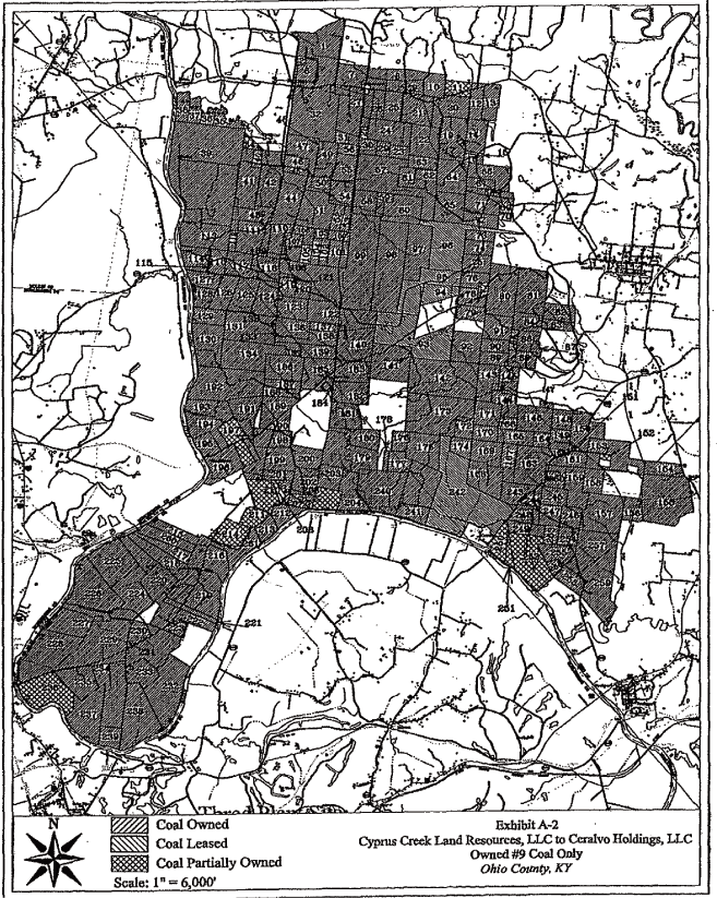
EXHIBIT B-1
Surface
and Surface Coal Mining Rights Only
| Item | Orig. L.C. No. | Acreage |
||
| 1. | 028-181(2) | 103 acres |
AND BEING a portion of the property conveyed to Peabody Coal Company and Beaver Dam Coal Company
from William I. Brown, et ux., by deed dated March 13, 1970, recorded in Deed Book 201, page 381,
in the Ohio County Clerk’s office.
| 2. | 028-242 | 32 acres |
AND BEING
the same property conveyed to Peabody Coal Company and Beaver Dam Coal Company from Ella
B. Bell, unmarried widow, by deed dated February 24, 1976, recorded in Deed Book 217, page 447, in
the Ohio County Clerk’s office.
| 3. | 028-296 | 220.09 acres |
AND BEING the same property conveyed to Peabody Coal Company from Big Rivers Electric Corporation
by deed dated May 13, 1988, recorded in Deed Book 265, page 418, in the Ohio County Clerk’s office.
4.
|
028-161, T.1 | 60.25 acres | ||||
| (except portion conveyed at Deed Book 237, page 90) | ||||||
| 028-161, T.2 | 75.00 acres | |||||
| (except portion conveyed at Deed Book 237, page 90) | ||||||
AND BEING a portion of the property conveyed to Sentry Royalty Company and Beaver Dam Coal Company
from Foster James, et ux., by deed dated December 15, 1966, recorded in Deed Book 177, page 317, in
the Ohio County Clerk’s office.
5.
|
028 -108, T.2 | 258 acres | ||||
| (except portion conveyed at Deed Book 237, page 90) | ||||||
AND BEING a portion of the property conveyed to Sentry Royalty Company and Beaver Dam Coal Company
from John Lindley, et ux., by deed dated May 17, 1960, recorded in Deed Book 155, page 151, in the
Ohio County Clerk’s office.
6.
|
028-122 | 168 acres | ||||
| (except portion conveyed at Deed Book 237, page 90) | ||||||
AND BEING a portion of the property conveyed to Sentry Royalty Company and Beaver Dam Coal Company
from Raymond T. Nall, widower, by deed dated February 14, 1961, recorded in Deed Book 178, page 18;
and also being the same property in which Peabody Coal Company conveyed its undivided 1/2 interest
to Beaver Dam Coal Company, expressly reserving all
38
underlying coal, by deed dated December 27, 1974, recorded in Deed Book 210, page 657; both
in the Ohio County Clerk’s office.
| 7. | 028-252 | 0.55 acres |
AND BEING
the same property conveyed to Peabody Coal Company from Edwin Brown, et ux., by deed
dated June 8, 1977, recorded in Deed Book 224, page 227, in the Ohio County Clerk’s office.
| 8. | 028-251 | 1.25 acres |
AND BEING the same property conveyed to Peabody Coal Company from Earl Powers, et ux., by
deed dated June 8, 1977, recorded in Deed Book 224, page 229, in the Ohio County Clerk’s office.
Common Sources of Title
(All recorded references are to the Ohio County, Kentucky, Clerk’s Office)
1. By Quitclaim Deed dated September 30, 1957, recorded in Deed Book 134, page 219, Homestead Coal
Company, a Kentucky corporation, conveyed all of the land it owned in Ohio County to Sentry Royalty
Company, a Nevada corporation. Also see the Quitclaim Deed dated December 1, 1967, recorded in Deed
Book 177, page 236.
2. By Merger approved by the Illinois Secretary of State on February 5, 1968, recorded July 28,
1972, in Miscellaneous Book 6, page 375, Sentry Royalty Company merged with Peabody Coal Company.
The merger occurred pursuant to Illinois law, and the instrument
recites that Peabody Coal Company,
an Illinois corporation, owned all of the stock of the non-surviving corporation.
3. By Deed dated March 29, 1968, recorded in Deed Book 178, page 395, Peabody Coal Company, an
Illinois corporation, conveyed all of the property it owned in Ohio County, Kentucky, to Peabody
Coal Company, a Delaware corporation.
4. By Deed dated September 12, 1989, recorded in Deed Book 271, page 109, Peabody Coal Company, a
Delaware corporation, conveyed all of the property it owned in Ohio County, Kentucky, to Peabody
Development Company, a Delaware corporation.
5. Pursuant to Section 266 of the Delaware General Corporation Law, Peabody Development Company, a
Delaware corporation, converted and changed its name to Peabody Development Company, LLC, a
Delaware limited liability company, effective December 16, 2003, recorded April 27, 2004, in
Miscellaneous Book 52, pages 627 - 630.
6. Pursuant to Section 226 of the Delaware General Corporation Law, Peabody Coal Company, a
Delaware corporation, converted and changed its name to Peabody Coal Company, LLC, a Delaware
limited liability company, effective July 11, 2005, of record August 25, 2005, in Miscellaneous
Book 55, pages 147 - 152.
7. By instrument effective September 12, 1989, dated December 20, 2005, and recorded in Deed Book
358, page 226, Peabody Coal Company, LLC, and Peabody Development Company, LLC, confirmed the
reserves transfer of September 12, 1989, at Deed Book 271, page 109.
39
8. By Corporate Special Warranty Deed dated and recorded December 20, 2005, in Deed Book 358, page
301, Peabody Coal Company, LLC, conveyed all of the property it owned in Ohio County, Kentucky, to
Peabody Development Company, LLC.
9. By Corporate Special Warranty Deed dated and recorded December 20, 2005, in Deed Book 358, page
308, Peabody Development Company, LLC, conveyed all of the property it owned in Ohio County,
Kentucky, to Central States Coal Reserves of Kentucky, LLC, a Delaware limited liability company.
10. By Deed of Confirmation effective December 20, 2005, dated December 27, 2005, and recorded
January 17, 2006, in Deed Book 358, page 583, Peabody Development Company, LLC, confirmed the
conveyance of the surface only of certain property previously conveyed at Deed Book 358, page 308,
to Central States Coal Reserves of Kentucky, LLC.
11. By instrument effective December 20, 2005, dated August 23, 2006, recorded August 24, 2006, in
Deed Book 362, page 558, Peabody Coal Company, LLC, confirmed that it had conveyed certain tracts
to Peabody Development Company, LLC.
12. By instrument effective December 20, 2005, dated August 23, 2006, recorded August 24, 2006, in
Deed Book 362, page 563, Peabody Development Company, LLC, confirmed that it had conveyed certain
tracts to Central States Coal Reserves of Kentucky, LLC.
13. Pursuant to Section 266 of the Delaware General Corporation Law, Beaver Dam Coal Company, a
Delaware corporation, converted and changed its name to Beaver Dam Coal Company, LLC, a Delaware
limited liability company, effective May 16, 2007, recorded May 21, 2007, in Miscellaneous Book 58,
pages 499 - 503.
14. And being a portion of the same property conveyed by Beaver Dam Coal Company, LLC and Central
States Coal Reserves of Kentucky, LLC, to Cyprus Creek Land Resources, LLC, by deed dated September
13, 2007, of record in Deed Book 370, page 144.
15. And being a portion of the same property conveyed by Cyprus Creek Land Resources, LLC to Cyprus
Creek Land Company by deed dated September 13, 2007, recorded in Deed Book 370, page 199.
16. And being a portion of the same property conveyed by Beaver Dam Coal Company, LLC and Central
States Coal Reserves of Kentucky, LLC to Cyprus Creek Land Resources, LLC, by Correction Special
Warranty Deed of Conveyance effective September 13, 2007, recorded March 28, 2008, in Deed Book
373, page 43.
Schedule of Known
Exceptions and Prior Conveyances
Exceptions and Prior Conveyances
1. Subject to the Notice of Royalty Interest in favor of William G. Parrott, et al., dated December
19, 1983, recorded in Miscellaneous Book 16, page 452, concerning the Third Boundary described
therein.
2. Subject to the Overriding Royalty Agreement dated June 1, 1967, recorded in Deed Book 179, page
259, between Sentry Royalty Company and W. B. Dozier, Helen Dozier, and Lula Hickman, concerning
the Third Boundary described therein.
40
3. Subject to the conveyance to A. J. Early of “all the gases, and all rights thereto” underlying
all property owned by Beaver Dam Coal Company within a boundary
containing 33,925.37 acres, by deed
dated March 22, 1928, recorded in Deed Book 74, page 103.
4. Item 4: Subject to the following instruments of record:
(a) The 1/4-acre cemetery excepted by heirs of John Howell in the deed dated and recorded
April 8, 1833, in Deed Book F, page 393;
(b) Highway right-of-way to Ohio County, Kentucky, dated February 13, 1931, recorded in Deed
Book 78, page 194;
(c) Highway right-of-way to the Commonwealth of Kentucky dated September 9, 1933, recorded
in Deed Book 81, page 595;
(d) Highway right-of-way to the Commonwealth of Kentucky dated September 19, 1933, recorded in
Deed Book 81, page 596;
(e) Conveyance of Raymond Nall Road by Big Rivers Electric Corporation, et al., to Ohio
County, Kentucky, dated January 10, 1984, recorded in Deed Book 249, page 599; and
(f) Pole Line Agreement from Bernie Tichenor, et ux., to Kentucky Utilities Company dated
March 17, 1947, recorded in Deed Book 104, page 331. The cited utility easement has been relocated
but no instrument appears of record to this effect. See the plat of record in Deed Book 237, page
102, which depicts the power line easement as located in 1980.
5. Item 5: Subject to the following instruments of record:
(a) The undivided 1/8 interest in the Alney Tichenor estate (179 acres) outstanding in
the heirs of Maria Tichenor and Squire W. Tichenor, wife and husband. Maria Tichenor last appears
of record in 1903 (Deed Book 30, page 453). The Affidavit of Descent dated April 17, 1950, recorded
April 22, 1950, in Deed Book 111, page 120, states that S. W. Tichenor died intestate circa 1945,
an unmarried resident of Ohio County, survived by the following persons who constitute his sole
heirs:
Clyde Tichenor
|
Son | 64 | Centertown, Ky. | 1/4 | ||||||
Gerda M. Tichenor
|
Daughter | 72 | Centertown, Ky. | 1/4 | ||||||
Melissa A. James
|
Daughter | 64 | Centertown, Ky. | 1/4 | ||||||
Willie L. Myers
|
Daughter | 68 | Alcoa, Tn. | 1/4 |
(b) Road reservation described in the deed dated September 19, 1919, recorded in Deed Book 57,
page 639, in which C. A. Lindley, et ux., and John Lindley, et ux., conveyed the 258 acre parent
tract to Homer Nation and Bert Nation. The road is located within
Surface Tract No. 028 - 197, T.1, as the same was conveyed to Theodore Hill, et ux., in 1919 (Deed Book 61, page 525).
(c) Agreement of Right of Way dated November 2, 1936, recorded in Deed Book 85, page 97, in
which Bert Nation, et ux., et al., granted a right-of-way across the subject tract to Kentucky
Natural Gas Corporation of Owensboro, Kentucky.
6. Item 6: Subject to the following instruments of record:
(a) The 168 acre tract is erroneously described in all instruments of record from
1875 to the present, which description fails to account for an 18 3/4 acre parcel described in 1830
at Deed Book F, page 242, comprising a northeastern portion of the 168 acre parent tract.
41
(b) The highway right-of-way deed dated September 6, 1933, recorded in Deed Book 81, page
593, by James N. Nall, et ux., to the Commonwealth of Kentucky, State Highway Commission.
(c) Pole Line Agreement dated May 13, 1947, recorded in Deed Book 104, page 392, by Raymond T.
Nall to Kentucky Utilities Company.
7. Item 8: Subject to the following highway rights-of-way of record:
(a) Deed
dated February 3, 1931, recorded in Deed Book 78, page 191, by J. N. Nall, et ux., to
Ohio County, Kentucky;
(b) Deed
dated August 22, 1931, recorded in Deed Book 78, page 216, by J. N. Nall, et ux., to
Ohio County, Kentucky; and
(c) Deed dated September 6, 1933, recorded in Deed Book 81, page 593, by J. N. Nall, et ux.,
to the Commonwealth of Kentucky, State Highway Commission.
END OF EXHIBIT B-1
42
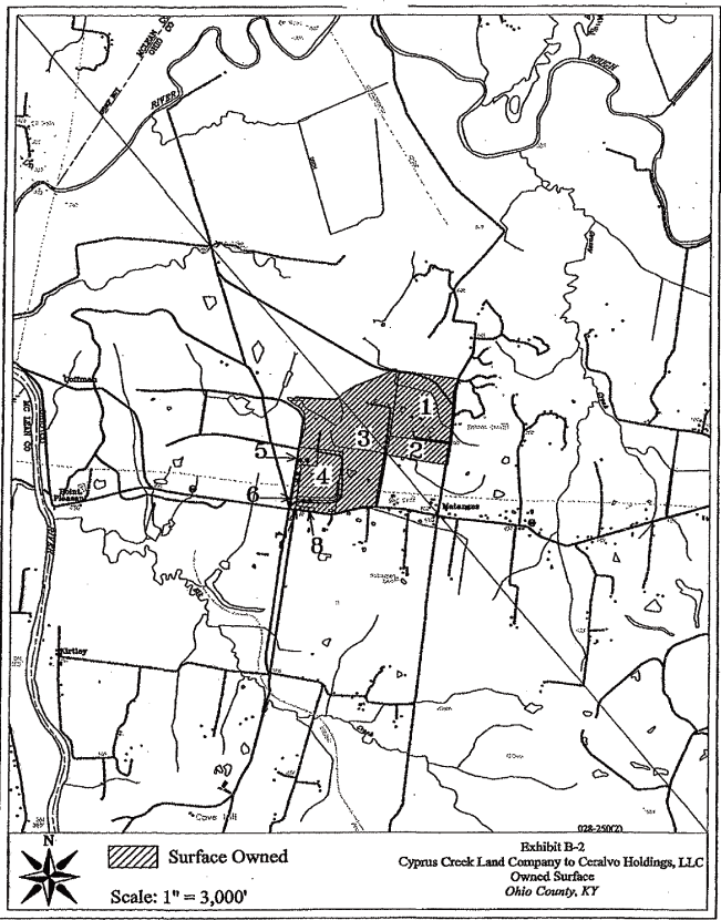
SCHEDULE B
Leased Property
All of Lessor’s right, title and interest in and to the following surface and/or coal tracts
situated in Ohio County, Kentucky: all of the #9 vein or seam of coal and the coal mining rights
and privileges appurtenant thereto, in, on and underlying the real property more particularly
described on Exhibit A attached hereto and depicted on the map attached as Exhibit B, both of the
aforesaid Exhibits are incorporated herein by reference and made a
part hereof, together with all
appurtenants thereunto belonging or in anywise appertaining, and being subject to the known
exceptions and prior conveyances more particularly set forth herein.
BEING the same property acquired by Ceralvo Holdings, LLC from Cyprus Creek Land Resources, LLC by
Assignment and Assumption of Mineral Leasehold Estate (Danks and Ray #9 Coal Only), dated March 31,
2008, a Memorandum of which being of record in Deed Book 373, Page 199, in the office of the Clerk
of Ohio County, Kentucky.
Underlying lease: Agreement between Athel W. Danks and Richard A. Danks and Amy Ray and Ed Ray in
favor of Peabody Coal Company dated August 25, 1972, a short form of which is of record in Deed
Book 200, Page 215, in the office of the Clerk of Ohio County, Kentucky.
2
EXHIBIT A
Tract
No. 028 - 215, Parcels 1 - 6
Parcel 1: Beginning at two beeches on the bank of Green River thence N. 12-1/2 E.
167 poles and 13 links to a stone; thence S. 68-1/4 E. 143 poles to a stone, thence S. 28 W. 76
poles and 23 links to a stone; thence S. 57-1/2 E. 30 poles and 8 links to a stone; thence S.
20-1/2 W. 66 poles to a hickory bush and stone on the bank of Green River; thence down the river to
the beginning, containing 131 acres.
Parcel
2: Beginning at a stone; thence N. 12-1/2 E. 58 poles and 12 links to a small ash
and stone; thence S. 68-1/4 E. 141 poles to a stone, thence South 2 West 38 poles and 5 links to a
stone; thence South 28 West 21 poles and 12 links to a stone; thence North 68-1/4 West 143 poles to
the beginning, containing 52 acres.
Parcel 3: Beginning at a stone; thence South 57-1/2 E. 30 poles and 8 links to a stone;
thence South 66 East 49 poles and 5 links to a stone; thence North
48-1/2 E. 20 poles and 7 links
to a stone in the Hartford and Ceralvo Road; thence North 65-1/2 East 43 poles and 16 links to a
stone in said road; thence North 50-3/4 E. 24 poles and 20 links to a stone; thence South 69 East
20 poles to two black oaks and a stone; thence North 36-3/4 East 8 poles and 17 links to a black
oak and stone; thence North 11 W. 33 poles and 5 links to a down poplar, black gum and stone;
thence North 9-1/2 East 38 poles and 20 links to a poplar and hickory; thence North 72-1/2 W. 32
poles to a black oak stump, hickory and stone; thence North 68-1/4 W. 113 poles and 20 links to a
stone; thence South 2 West 38 poles and 5 links to a stone; thence S. 28 W. 98 poles and 10 links
to the beginning, containing 115-1/2 acres.
Parcel 4: Beginning at a stone in the original line between Presley L. Wood and D. W.
Kimmel on the West side of the Hartford and Ceralvo road; thence with said road N. 36 1/4 E. 31
rods and 8 links to a stone, thence with said road N. 26 E. 11 rods and 20 links to a stone, thence
with the road that connects the Hartford and Ceralvo road with the Hartford and South Carrollton
road, N. 42 1/4 W. 35 rods and 16 links to a stone; thence S. 9 1/2 W. 34 rods to a black gum down
poplar and stone; thence S. 11 E. 30 rods to the beginning, containing Six acres more or less.
Parcel
5: Beginning at a black gum, the South west corner of J. O. Kimbley’s land, thence North
104-8/11 poles to a stone in the original line thence North 70 West 91 poles to a stone in a
branch, thence North 3 East 57 1/2 poles to a stone on bank of branch in M. F. Kimbley’s line,
thence with his line North 87 1/2 West 27 poles to a poplar tree and
stone, E. W. Smith’s corner in
M. F. Kimbley’s line, thence with E. W. Smith’s line South 152 8/11 poles to a gum tree and stone
in V. B. Morton’s line, thence South 70 East 121 poles to the beginning and containing 81 acres
more or less.
Parcel 6: Beginning at a stone in Hartford and Ceralvo Road; thence South 63-1/2 East 30
rods and 23 links to a stone; thence South 17-3/4 West 12 rods and 15 links to a stone in the back
line of the Town Plat of Ceralvo; thence South 64-1/2 East 23 rods and 17 links to a stone in Mrs.
Druzilla Barnard’s line; thence North [28 E] 76-1/2 rods to a stone and two black oaks, P.
- 6 -
L.
Wood’s corner; thence N. 69 W. 20 rods to a stone; thence South 50-3/4 West 24 rods and 20
links to a stone in the Hartford and Ceralvo road; thence S. 65-1/2 W. with said road 50 rods and
10 links to the beginning, containing 16 acres more or less.
AND BEING the same property in which the No. 9 seam of coal was leased to Peabody Coal Company by
Athel W. Danks, et vir., and Ama W. Ray, et vir., by Agreement dated August 25, 1972, recorded in
Deed Book 200, page 215, in the Ohio County Clerk’s office.
Common Sources of Title
All recording references are to the Office of the Ohio County Clerk:
1. By Deed dated September 12, 1989, recorded in Deed Book 271, page 109, Peabody Coal Company, a
Delaware corporation, conveyed all of the property it owned in Ohio County, Kentucky, to Peabody
Development Company, a Delaware corporation.
2. Pursuant to Section 266 of the Delaware General Corporation Law, Peabody Development
Company, a Delaware corporation, converted and changed its name to Peabody Development Company,
LLC, a Delaware limited liability company, effective December 16, 2003, recorded April 27, 2004, in
Miscellaneous Book 52, pages 627 - 630.
3. Pursuant to Section 226 of the Delaware General Corporation Law, Peabody Coal Company, a
Delaware corporation, converted and changed its name to Peabody Coal Company, LLC, a Delaware
limited liability company, effective July 11, 2005, of record August 25, 2005, in Miscellaneous
Book 55, pages 147 - 152.
4. By
instrument effective September 12, 1989, dated December 20, 2005, and recorded in Deed Book
358, page 226, Peabody Coal Company, LLC, and Peabody Development Company, LLC, confirmed the
reserves transfer of September 12, 1989, at Deed Book 271, page 109.
5. By Corporate Special Warranty Deed dated and recorded December 20, 2005, in Deed Book 358, page
301, Peabody Coal Company, LLC, conveyed all of the property it owned in Ohio County, Kentucky, to
Peabody Development Company, LLC.
6. By Corporate Special Warranty Deed dated and recorded December 20, 2005, in Deed Book 358, page
308, Peabody Development Company, LLC, conveyed all of the property it owned in Ohio County,
Kentucky, to Central States Coal Reserves of Kentucky, LLC, a Delaware limited liability company.
7. By Deed of Confirmation effective December 20, 2005, dated December 27, 2005, and recorded
January 17, 2006, in Deed Book 358, page 583, Peabody Development Company, LLC, confirmed the
conveyance of the surface only of certain property previously conveyed at Deed Book 358, page 308,
to Central States Coal Reserves of Kentucky, LLC.
8. By instrument effective December 20, 2005, dated August 23, 2006, recorded August 24, 2006, in
Deed Book 362, page 558, Peabody Coal Company, LLC, confirmed that it had conveyed certain tracts
to Peabody Development Company, LLC.
- 7 -
9. By Instrument effective December 20, 2005, dated August 23, 2006, recorded August 24, 2006,
in Deed Book 362, page 563, Peabody Development Company, LLC, confirmed that it had conveyed
certain tracts to Central States Coal Reserves of Kentucky, LLC.
10. By Assignment and Assumption of Mineral Leasehold Estate dated September 10, 2007, of record in
Deed Book 370, page 368, Central States Coal Reserves of Kentucky, LLC assigned to Cyprus Creek
Land Resources, LLC, a Delaware limited liability company, all of its right, title and interest in
and to the Dank/Ray Agreement.
Schedule of Known
Exceptions and Prior Conveyances
1. Subject to an overriding royalty interest referred to in the Notice of Royalty Interest in favor
of William G. Parrott, et al, dated December 19, 1983, recorded in Miscellaneous Book 16, page 452,
in the Office of the Ohio County Clerk, concerning the Fourth Boundary described therein.
2. Parcels 2, 5 and 6 are subject to the unrecorded Affidavit of Descent of E. B. Wood executed by
Athel W. Danks in 1972, which is in the possession of the grantors herein.
3. Parcels 3 and 4 are subject to the coal reservation by Athel Wood Danks, et vir., et al., by
deed dated August 15, 1946, recorded in Deed Book 102, page 304.
4. Parcel 5 is subject to the coal reservation by E. B. Wood by deed dated May 22, 1917, recorded
in Deed Book 53, page 249.
- 8 -