Attached files
| file | filename |
|---|---|
| EX-32 - CERTIFICATIONS - Discovery Energy Corp. | ex32-1.htm |
| EX-31 - CERTIFICATIONS - Discovery Energy Corp. | ex31-1.htm |
UNITED STATES
SECURITIES AND EXCHANGE COMMISSION
Washington, D.C. 20549
Form 10-K/A
Amendment No. 1
|
ý |
Annual report pursuant section 13 or 15(d) of the Securities Exchange Act of 1934 |
|
r |
Transition report pursuant section 13 or 15(d) of the Securities Exchange Act of 1934 |
|
Commission file number 000-53520 |
|
Santos Resource Corp.
(Exact name of registrant as specified in its charter)
|
Nevada (State of Incorporation) |
98-0507846 (I.R.S. Employer Identification No.) |
|
11450 - 201A Street |
|
(Address and telephone number of Registrant's principal executive offices) |
|
Securities registered pursuant to Section 12(b) of the Act: |
None |
|
|
Securities registered pursuant to Section 12(g) of the Act: |
Common Stock |
Indicate by check mark if the registrant is a well-known seasoned issuer, as defined in Rule 405 of the Securities Act.
Yes r No ý
Indicate by check mark if the registrant is not required to file reports pursuant to Section 13 or Section 15(d) of the Act.
Yes r No ý
Note - Checking the box above will not relieve any registrant required to file reports pursuant to Section 13 or 15(d) of the Exchange Act from their obligations under those Sections.
Indicate by check mark whether the registrant (1) has filed all reports required to be filed by Section 13 or 15(d) of the Securities Exchange Act of 1934 during the preceding 12 months (or for such shorter period that the registrant was required to file such reports), and (2) has been subject to such filing requirements for the past 90 days.
Yes ý No r
Indicate by check mark whether the registrant has submitted electronically and posted on its corporate Web site, if any, every Interactive Data File required to be submitted and posted pursuant to Rule 405 of Regulation S-T during the preceding 12 months (or for such shorter period that the registrant was required to submit and post such files).
(Not applicable to registrant) Yes r No r
2
Indicate by check mark if disclosure of delinquent filers pursuant to Item 405 of Regulation S-K is not contained herein, and will not be contained, to the best of registrant's knowledge, in definitive proxy or information statements incorporated by reference in Part III of this Form 10-K or any amendment to this Form 10-K.
ý
Indicate by check mark whether the registrant is a large accelerated filer, an accelerated filer, a non-accelerated filer, or a smaller reporting company. See the definitions of "large accelerated filer," "accelerated filer" and "smaller reporting company" in Rule 12b-2 of the Exchange Act.
Large accelerated filer r |
Accelerated filer r |
Non-accelerated filer r
|
Smaller reporting company ý |
Indicate by check mark whether the registrant is a shell company (as defined in Rule 12b-2 of the Exchange Act).
Yes ý No q
The aggregate market value of the common equity stock held by non-affiliates of the Registrant as of August 31, 2009, the last business day of the Registrant's most recently completed second fiscal quarter, was $2,170,100 (computed based upon the price at which the Company's common stock was last sold).
Indicate the number of shares outstanding of each of the registrant's classes of common stock, as of the latest practicable date.
|
|
Class: common stock - $0.001 par value |
|
Outstanding at May 28, 2010: 32,076,500 |
|
Documents incorporated by reference. |
None |
EXPLANATORY NOTE
This amendment on Form 10-K/A is being filed to revise Part I Item 1 Business; Item 2 Properties; and Part IV Item 15 Exhibits, Financial Statement Schedules of our annual report on Form 10-K for the year ended February 28, 2010 (the "Report") filed with the Securities and Exchange Commission (the "SEC") on May 28, 2010. This amendment to the Report is filed in response to comments issued by the SEC and to clarify certain prior disclosures. This amendment to the Report does not alter any part of the content of the Report, except for the changes and additional information provided herein. This amendment continues to speak as of the date of the Report. We have not updated the disclosures contained in this amendment to reflect any events that occurred at a date subsequent to the filing of the Report. The filing of this amendment is not a representation that any statements contained in the Report or this amendment are true or complete as of any date subsequent to the date of the Report. This amendment does not affect the information originally set forth in the Report, the remaining portions of which have not been amended.
3
PART I
ITEM 1. BUSINESS
Overview
Santos Resource Corp. (the "Company" or "Santos") was incorporated under the laws of the state of Nevada on May 24, 2006. We have not commenced business operations and we are considered an exploration stage company. We are defined as a "shell company" under the Rule 405 of the Securities Act and Rule 12b-2 of the Exchange Act because we have nominal operations and nominal assets. To date, our activities have been limited to organizational matters, obtaining a geological report on the Lourdeau Claims and the preparation and filing of a registration statement on Form S-1.
Plan of Operation
Our only asset is the right to explore on the Lordeau Property, which consists of 18 claims over a surface area of 900.75 hectares or 9.01 km2 in the province of Quebec, Canada. We have no other assets and we have a cash balance of $307 as of February 28, 2010. If we are successful in obtaining financing, our business plan is to proceed with the exploration of the Lourdeau Property to determine whether there are commercially exploitable reserves of base and precious metals. We presently do not have funds to meet our general operating expenses and to meet our obligations under the Property Option Agreement. We currently do not have any arrangements for financing and we may not be able to obtain financing when required. We are currently relying on loans that may be available to Santos from management. We do not have the funds to conduct the recommended exploration program. Due to extreme weather conditions, exploration activities can only be conducted between June and August of each year. We are attempting to raise additional money, and have not started the exploration program. If we are able to raise additional money, we may conduct the exploration program recommended by Mr. Michel Boily in the summer of 2010. We anticipate the recommended program will cost approximately $102,224 (CAD$107,570), and will take approximately 5 weeks to complete.
Technical Report on Properties
Mr. Michel Boily, Ph.D., P. Geo. was hired by Santos to provide a Technical Report in July 2007 on the Lourdeau Claims. Mr. Boily has been continuously practicing in his profession as a geologist since 1988, and is a specialist of granitoid-hosted precious and rare metal deposits in Quebec. He graduated from the University of Montreal (1988) in Quebec, Canada, with a PhD in geology. He is a registered Professional Geologist in good standing with l'Ordre des Géologues du Québec (permit no. 1097). Mr. Boily does not have any interest in the Lourdeau Property or the Company.
Mr. Boily does not have any interest in the Lourdeau Property or the Company. The report is based on published and private reports, maps and data provided by the Company and in the public domain. Mr. Boily's report details the geological and exploration history of the Lourdeau Property, including the land status, climate, geology and mineralization. Based upon previous exploration activity in the area, Mr. Boily recommends the Company conduct a specific exploration program on the Lourdeau Property. The purpose of this report was to evaluate the area of the claim group, and the prior exploration work conducted on the claims, and to recommend an exploration program.
Recommended Exploration Program
Mr. Boily recommends a systemic surface sampling program of the Lourdeau Vein site and its vicinity, and the northern edge of the Lourdeau Hill, incorporating grab and channel sampling, in order to get a solid geochemical assay database. Mr. Boily recommends obtaining a helicopter-borne geophysical survey to cover the rest of the Lourdeau Property. Geophysical survey means the collection of information systematically. Mr. Boily recommends the geophysical magnetic and radiometric surveys to be done on a 100 meter spaced grid. This program is estimated to cost approximately $102,224 (CAD$107,570), and will take approximately 5 weeks to complete.
4
The recommended exploration program costs approximately $102,224 (CAD$107,570) and consists of the following:
|
Geophysical Survey |
Approximate in US$ |
Cost in CAD$ |
|
Spectrometry, Gradiomag (Helimager) and VLF |
|
|
|
$200 x 120 km (line spacing: 100 m) |
$22,807 |
CAD$24,000 |
|
Mobilization/demobilization |
$14,255 |
CAD$15,000 |
|
Channel and Grab Sampling |
|
|
|
Analyses: 150 samples @ $50/sample |
$7,127 |
CAD$7,500 |
|
Supervision: geologist/ 2 technicians for 5 days @ $925/day |
$4,395 |
CAD$4,625 |
|
Transport and Lodging |
|
|
|
Transport Montreal-Radisson . |
$950 |
CAD$1,000 |
|
Lodging and food for 3 people x 5 days |
$3,564 |
CAD$3,750 |
|
Rentals (truck, ATV, saws, etc.) |
$4,752 |
CAD$5,000 |
|
Helicopter |
|
|
|
3 hours/day x 5 days x $1,250/day |
$17,818 |
CAD$18,750 |
|
Fuel: 3 hours/day x 5 days x 160 liters x $2/liters |
$4,561 |
CAD$4,800 |
|
Mineralogy: SEM Analyses |
|
|
|
5 samples x $500/sample |
$2,376 |
CAD$2,500 |
|
|
|
|
|
Subtotal |
$82,605 |
CAD$86,925 |
|
Contingency (10%) |
$8,261 |
CAD$8,693 |
|
Total before taxes |
$90,866 |
CAD$95,618 |
|
GST (5%) |
$4,543 |
CAD$4,781 |
|
QST (7.5%) |
$6,815 |
CAD$7,171 |
|
Grand Total |
$102,224 |
CAD$107,570 |
Depending on the results of this program, the next phase could involve a drilling campaign which would define the targets acquired during the geophysical surveys and sampling campaign. The focus of the drilling will be the uranium-mineralized sandstones at the Lourdeau Hill, with the gold, copper and silver-mineralized metavolcanic constituting secondary targets.
Geological Exploration Program
Our mineral claims presently do not have any mineral reserves. There is no mining plant or equipment located on the property.
We have not yet commenced physical exploration of the Lourdeau Claims. Our exploration program is exploratory in nature and there is no assurance that mineral reserves will be found.
The exploration program proposed by the Company's independent consultant is designed to determine whether mineralization exists to the extent that further exploration is recommended to outline any such mineralized zones. It is uncertain at this time the precise quantity of minerals in the property that would justify actual mining operations. If we decide to abandon our mineral claim at any stage of our exploration program, we intend to acquire other properties and conduct similar exploration programs. The other properties may be located in the same mining district or we may in the future explore properties located in other jurisdictions, which may include other provinces in Canada, or in the United States. Currently, the Company does not have any other properties or any intentions of acquiring any other properties.
5
We plan to conduct a systemic surface sampling program of the Lourdeau Vein site and its vicinity, and the northern edge of the Lourdeau Hill, incorporating grab and channel sampling, in order to get a solid geochemical assay database. Mr. Boily recommends obtaining a helicopter-borne geophysical survey to cover the rest of the Lourdeau Property. Mr. Boily recommends the geophysical magnetic and radiometric surveys to be done on a 100 m spaced grid.
Depending on the results of this program, the next phase could involve a drilling campaign which would define the targets acquired during the geophysical surveys and sampling campaign. The focus of the drilling will be the uranium-mineralized sandstones at the Lourdeau Hill, with the gold, copper and silver-mineralized metavolcanic constituting secondary targets.
We anticipate that additional funding will be in the form of equity financing from the sale of our common stock. However, we cannot provide investors with any assurance that we will be able to raise sufficient funding from the sale of our common stock to fund additional phases of the exploration program should we decide to proceed. We believe that debt financing will not be an alternative for funding any further phases in our exploration program. The risky nature of this enterprise and lack of tangible assets places debt financing beyond the credit-worthiness required by most banks or typical investors of corporate debt until such time as an economically viable mine can be demonstrated. We do not have any arrangements in place for any future equity financing.
We have not hired any personnel to perform the geological work on the Lourdeau Property. Any geologist that we hire in the future will be responsible for selecting the appropriate personnel and incurring all worker-related costs, which we will reimburse for such services.
Employees
Initially, we intend to use the services of contractors and consultants for exploration work on our properties. At present, we have no paid employees. We believe keeping a low number of full-time employees will conserve cash and allow greater flexibility in the future.
Regulations
We will be required to comply with all regulations, rules and directives of governmental authorities and agencies applicable to the exploration of minerals in Canada generally, and in Quebec specifically.
The key government agency in charge of mining in Quebec, Canada is the Ministry of Natural Resources, or ministère des Ressources naturelles. The Ministry of Natural Resources administers three laws relevant to the mining industry in Quebec: (i) The Mining Act (Loi sur les mines); (ii) The Mining Duties Act (Loi concernant les droits sur les mines); and (iii) SOQUEM Act (Loi sur la société québécoise d'exploration minière).
The Quebec Mining Act allows a mineral explorer to claim a portion of available governmental lands for the exclusive ownership of the mining rights area. Pursuant to the Quebec Mining Act, a foreign company working on mining claims in the Province of Quebec must register with the provincial government of Quebec. We are not registered with the government of Quebec, and we will need to register with the government of Quebec before we work on the Lourdeau Claims.
We currently have no costs to comply with environmental laws concerning our exploration program. A permit is required to penetrate the forested areas with the obligation to store along access zones cut lumber of potential commercial value. We do not expect to be required to obtain additional governmental authorizations or to undertake studies of environmental impact and project approval unless and until we discover commercially viable quantities of mineral deposits. Under the Quebec Mining Act, should we discover mineral deposits and desire to commence mining operations, we will be required to file a mining site rehabilitation plan with the Natural Resources Ministry. This rehabilitation plan discusses how the operator intends to rehabilitate the property following its intended use of the property and includes an estimate of the costs involved in the rehabilitation. We may also be required to obtain permits and
6
distribution rights-of-way from the Natural Resources Ministry for the construction of the access roads and power lines.
Other laws are indirectly relevant to our business, including the Quebec Environmental Quality Act and the Canadian Environmental Assessment Act. These acts are administered by separate provincial and federal governmental agencies that have the separate authority to approve or require changes to a company's impact assessment. Notwithstanding this separate authority, these federal and provincial governmental agencies generally attempt to coordinate their review and approval procedures.
The Quebec Environment Quality Act, includes standards related to protection of the soil, water, and air quality. Article 22 of the Environmental Quality Act requires that any proponent who wants to build or modify the environment in any way obtain a certificate of approval from the Quebec Environment Ministry. Directive 19, established under the Environmental Quality Act, sets criteria for environmental impact studies to accompany applications for certificates of approval under the Act, and also sets standards on the ways different types of mines should operate.
We are prepared to engage professionals, if necessary, to ensure regulatory compliance, but in the near term we expect our activities to require minimal regulatory oversight. If we expand the scope of our activities in the future, it is reasonable to expect expenditures on compliance to rise.
Environmental Factors
We will also have to sustain the cost of reclamation and environmental remediation for all work undertaken which causes sufficient surface disturbance to necessitate reclamation work. Both reclamation and environmental remediation refer to putting disturbed ground back as close to its original state as possible. Other potential pollution or damage must be cleaned-up and renewed along standard guidelines outlined in the usual permits. Reclamation is the process of bringing the land back to a natural state after completion of exploration activities. Environmental remediation refers to the physical activity of taking steps to remediate, or remedy, any environmental damage caused, i.e. refilling trenches after sampling or cleaning up fuel spills. Our initial programs do not require any reclamation or remediation other than minor clean up and removal of supplies because of minimal disturbance to the ground. The amount of these costs is not known at this time as we do not know the extent of the exploration program we will undertake, beyond completion of the recommended three phases described above. Because there is presently no information on the size, tenor, or quality of any resource or reserve at this time, it is impossible to assess the impact of any capital expenditures on our earnings or competitive position in the event a potentially economic deposit is discovered.
ITEM 2. PROPERTIES
Principal Offices
Currently, we are not paying any monthly rent for our office space located at 11450 - 201A Street, Maple Ridge, British Columbia.
Mineral Properties
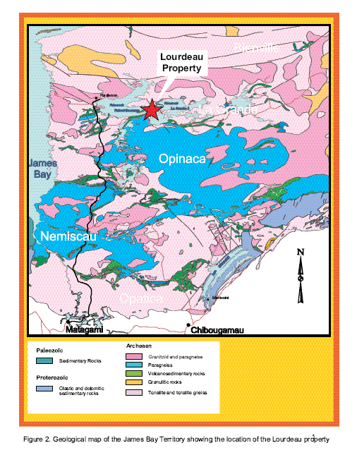
Our only property is an option to acquire a 75% interest in and to 18 mineral claims covering approximately 900.75 hectares (9.01 km2) called the Lourdeau Claims. The Lourdeau Claims are located in the La Grande geological area of Quebec, Canada, in the James Bay Territory about 620 miles (1,000 km) north of Montreal, Quebec.
We do not own or lease any property other than our interest in the Lourdeau Claims.
Glossary of Mining Terms
The following is a list of chemical elements by symbols used in this annual report.
7
"A" means the chemical symbol for argon;
"Au" means the chemical symbol for gold;
"Ag" means the chemical symbol for silver;
"C" means the chemical symbol for carbon;
"Co" means the chemical symbol for cobalt;
"Cr" means the chemical symbol for chromium;
"Cu" means the chemical symbol for copper;
"Fe" means the chemical symbol for iron;
"Mo" means the chemical symbol for molybdenum;
"Ni" means the chemical symbol for nickel;
"Pb" means the chemical symbol for lead;
"Th" means the chemical symbol for thorium;
"Ti" means the chemical symbol for titanium;
"U" means the chemical symbol for uranium;
"V" means the chemical symbol for vanadium;
"Zn" means the chemical symbol for zinc; and
"Zr" means the chemical symbol for zirconium.
The following is a glossary of certain terms used in this annual report.
"alteration" means any change in the mineralogical composition of a rock that is brought about by physical or chemical means, especially by the action of hydrothermal solutions;
"anomaly" means a geological feature, especially in the subsurface, distinguished by geological, geophysical or geochemical means, which is different from the general surroundings and is often of potential economic value having a geochemical or geophysical character which deviates from regularity;
"Archean" means relating to or being the earliest eon of geological history or the corresponding system of rocks;
"arenite" means arenaceous rock; a sandstone;
"arenaceous" means resembling, derived from, or containing sand;
"argillaceous" means relating to or containing clay or clay minerals;
"assay" means to analyze the proportions of metal in a rock or overburden sample; to test an ore or mineral for composition, purity, weight or other properties of commercial interest;
8
"autunite" means a radioactive, usually lemon-yellow calcium phosphate mineral that occurs in tabular crystals and in scales and that is an ore of uranium;"bornite" means a brittle metallic-looking mineral that consists of a sulfide of copper and iron and is a valuable copper ore;
"chalcocite" means a black or gray lustrous metallic mineral that consists of a sulfide of copper and is an important copper ore;
"chalcopyrite" means a yellow mineral that consists of a sulfide of copper and iron and is an important copper ore;
"chlorite" means any of a group of usually green silicate minerals associated with and resembling the micas;
"chloritization" means a metasomatic process in which the dark minerals of rocks and sometimes also the matrix itself are replaced by chlorites;
"cps" means centipoises, one cps means one one-hundredth of the unit of dynamic viscosity in the centimetre gram second system of units;
"deposit" means a mineralized body which has been physically delineated by sufficient drilling, trenching and/or underground work, and found to contain a sufficient average grade of metal or metals to warrant further exploration and/or development expenditures. Such a deposit does not qualify as a commercially mineable ore body or as containing reserves of ore, until final legal, technical and economic factors have been resolved;
"desiccation" means the process of becoming dry;
"dextral" means facing, or located on the right side;
"diagenesis" means the physical and chemical changes undergone by a sediment during lithification and compaction, excluding erosion and metamorphism;
"dip" means the maximum angle that a structural surface makes with the horizontal, measured perpendicular to the strike of the structure and in the vertical plane;
"epigenetic" means the change in the mineral content of a rock because of outside influences;
"extrapolate" means to infer or estimate by extending or projecting known information;
"feldspar" means any of a group of abundant rock-forming minerals occurring principally in igneous, plutonic, and some metamorphic rocks, and consisting of silicates of aluminum with potassium, sodium, calcium, and, rarely, barium;
"felsic" means a igneous rock having abundant light-coloured minerals;
"g/t" means grams per metric tonne;
"geophysical survey" means a scientific method of prospecting that measures the physical properties of rock formations. Common properties investigated include magnetism, specific gravity, electrical conductivity and radioactivity;
"hectare" means a square of 100 meters on each side;
9
"hematite" means a red, grey, or black mineral, found as massive beds and in veins and igneous rocks. It is the chief source of iron;
"homogeneous" means composed of similar or identical parts or elements;
"host" means a rock or mineral that is older than rocks or minerals introduced into it;
"hydrothermal" means pertaining to hot water, especially with respect to its action in dissolving, redepositing and otherwise producing mineral changes within the earth's crust;
"igneous" means a classification of rocks formed from the solidification from a molten state. If the rock crystallizes within the crust, it is said to be intrusive, while if it flows onto the surface, it is extrusive;
"komatiitic" are ultramafic mantle-derived volcanic rocks;
"lb/t" means pounds per tonne;
"lenticular" means having the shape of a double-convex lense.
"mafic mineral" means a mineral that is composed predominantly of the ferromagnesian rock-forming silicates;
"mag" means a geophysical survey method which measures the magnetic properties of rocks;
"malachite" means a mineral, the green basic carbonate of copper occurring in crystals of the monoclinic system or (more usually) in masses;
"metallogeny" means the branch of the theory of minerals that investigates regional uniformities in the formation and location of ore deposits;
"metamorphism" is the solid-state recrystallization of pre-existing rocks due to changes in physical and chemical conditions, primarily heat, pressure, and the introduction of chemically active fluids;
"metavolcanic" means rock first produced by a volcano, either as lava or tephra;
"metasediments" means sediment or sedimentary rock that shows evidence of having been subjected to metamorphism;
"mineralization" means the process or processes by which a mineral or minerals are introduced into a rock resulting in concentration of metals and their chemical compounds within a body of rock;
"muscovite" means a colorless to pale brown form of mica consisting of a silicate of aluminum and potassium;
"NI 43-101" means the Canadian National Instrument 43-101 "Standards of Disclosure for Mineral Projects" adopted by the Canadian Securities Administrators;
"nodule" means a small knobbly rock or mineral cluster;
"NSR" means net smelter return royalty;
"paleotopography" means the topography of a given area in the geologic past;
"petrogenetic" means the origin or formation of rocks;
"petrography" means description and systematic classification of rocks;
10
"ppb" means parts per billion;
"ppm" means parts per million;
"Proterozoic" means geologic time between the Archean and Paleozoic eras, that is, from 2500 million to 550 million years ago;
"quartz" means a mineral composed of silicon dioxide, crystalline silica, commonly in white masses, next to feldspar, the commonest mineral;
"radiometric" means measurement of geologic time by means of the rate of disintegration of radioactive elements;
"reticulate" means rock texture in which crystals are partly altered to a secondary material, forming a network that encloses the remnants of the original mineral;
"sample" means a small portion of rock, soil or a mineral deposit taken so that the metal content can be determined by assaying;
"sampling" means selecting a fractional but representative part of a rock, soil, or a mineral deposit for analysis;
"scintillometer" means scientific device used to measure small fluctuations of the refractive index of air caused by variations in temperature, humidity, and pressure;
"schist" means a metamorphic crystalline rock that has a closely foliated structure and can be split along approximately parallel planes;
"sediment" means solid material that has settled down from a state of suspension in a liquid. More generally, solid fragmental material transported and deposited by wind, water or ice, chemically precipitated from solution, or secreted by organisms, and that forms in layers in loose unconsolidated form;
"sericite" means a kind of muscovite occurring in silky scales having a fibrous structure;
"silicification" means a metamorphic rock characterized by strong foliation or schistosity;
"schistosity" means the parallel arrangement of shaly or prismatic minerals like micas and amphiboles resulting from nonhydrostatic stress in metamorphism;
"stratigraphy" means the geology that deals with the origin, composition, distribution, and succession of strata;
"strike" means direction or trend of a geologic structure;
"tectonic" means the study of the movements and deformation of the crust on a large scale, including epeirogeny, metamorphism, folding, faulting, and plate tectonics;
"topography" is a description or representation of the features and configuration of land surfaces;
"U3O8" means uranium oxide concentrate, the mixture of uranium oxides produced after milling uranium ore from a mine;
"UTM" means Universal Transverse Mercator, a grid reference system;
11
"vein" means a precipitation or deposit from a hydrothermal fluid of, commonly, quartz, carbonate minerals and metallic minerals into a fissure or crack or other geological structure.
Description of Mineral Properties
The sections below describing the property are excerpts from a technical report dated August 2007 prepared by Mr. Boily, our consulting geologist. Mr. Boily has not visited the site and no visual inspection has been performed. Mr. Boily's recommendations are based solely on his interpretation of published reports. No drilling was conducted for the benefit of his technical report.
Property Description and Location
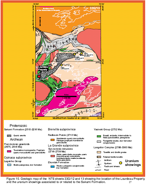
The Lourdeau Property is located in the La Grande geological area of Quebec in the James Bay Territory about 621 miles or 1,000 kilometers north of Montreal (see Figures 1 to 3). The property lies on the eastern shore of the La Grande 3 Reservoir ("LG-3") roughly 1.6 miles or 2.6 kilometers east-northeast from a major Hydro-Quebec levee. The property consists of 18 continuous map designed claim units (or cells) in the NTS 32G/12 sheet for a total surface of 900.75 hectares or 9.01 km2 (see Figure 4). The claims block is centered at UTM coordinates 435250 E and 5948300 N, (NAD83; zone 18) or 75o58'45" W and 53o40'45" N with the details of the titles given in Table 1. To the knowledge of Mr. Boily, the property is devoid of royalties, back-in-rights payments or other encumbrances. According to Quebec government records, no part of the land covered by the property is a park or mineral reserve. However, according to the Quebec Government's decree no. 241-86, exploration on 16 claims is allowed under specific conditions related to the development and utilization of water power on the LG-3 Reservoir. As parts of these claims are located on the shore of the LG-3 Reservoir, any exploration work on the property that is located on the shore will need approval from Hydro-Quebec. The Lourdeau Property is not subject to environmental liabilities except for those specified in the "Loi sur les Mines" (L.R.Q. chapter M-13.1), the Quebec Mining Act. The Quebec Mining Act imposes obligations on the mining industry to rehabilitate and restore the environment from the adverse effects of mining activities. The environmental restoration obligations apply to open pit or underground mines and tailings areas, and identify who must carry out such work, and particularize what must be done.
Table 1. List of map designed claims for the Lourdeau property
|
Title No. |
Surface Area in Ha |
Titleholder |
Expiry Date |
|
CDC87500* |
50,03 |
Starfire Minerals Inc. |
2010/07/18 |
|
CDC87501* |
50.03 |
Starfire Minerals Inc. |
2010/07/18 |
|
CDC87502* |
50.03 |
Starfire Minerals Inc. |
2010/07/18 |
|
CDC87503* |
50.03 |
Starfire Minerals Inc. |
2010/07/18 |
|
CDC87504* |
50.03 |
Starfire Minerals Inc. |
2010/07/18 |
|
CDC87505 |
50.04 |
Starfire Minerals Inc. |
2010/07/18 |
|
CDC87506 |
50.04 |
Starfire Minerals Inc. |
2010/07/18 |
|
CDC87507* |
50.04 |
Starfire Minerals Inc. |
2010/07/18 |
|
CDC87508* |
50.04 |
Starfire Minerals Inc. |
2010/07/18 |
|
CDC87509* |
50.04 |
Starfire Minerals Inc. |
2010/07/18 |
|
CDC87510* |
50.05 |
Starfire Minerals Inc. |
2010/07/18 |
|
CDC87511* |
50.05 |
Starfire Minerals Inc. |
2010/07/18 |
|
CDC87512* |
50.05 |
Starfire Minerals Inc. |
2010/07/18 |
|
CDC87513* |
50.05 |
Starfire Minerals Inc. |
2010/07/18 |
|
CDC87514* |
50.05 |
Starfire Minerals Inc. |
2010/07/18 |
|
CDC87515* |
50.05 |
Starfire Minerals Inc. |
2010/07/18 |
|
CDC87516* |
50.05 |
Starfire Minerals Inc. |
2010/07/18 |
|
CDC87517 |
50.05 |
Starfire Minerals Inc. |
2010/07/18 |
|
*Decree no. 241-86 |
12
Location, Accessibility, Climate, Local Resources, Infrastructure and Physiography

13
14

15
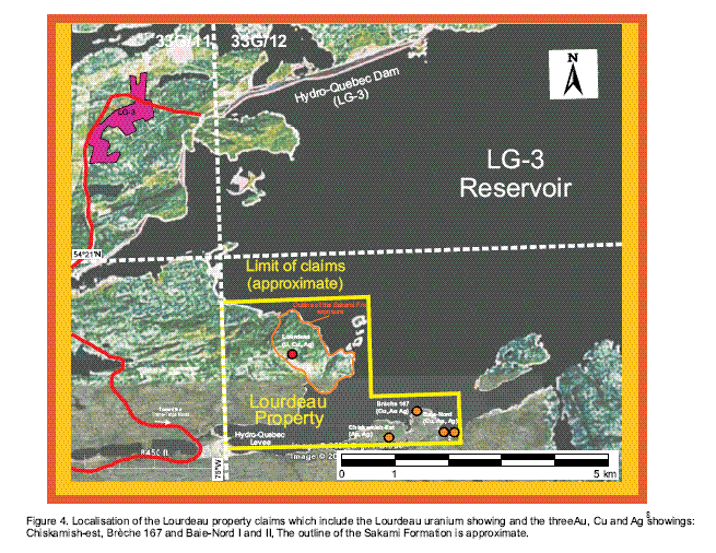
Access from the south to the property is about 352 miles or 568 kilometers via the James Bay Road from the town of Matagami to the crossing of Trans-Taiga Road. From Radisson we travel south for 32 miles or 52 kilometers upon reaching this intersection (see Figure 3). From there, we progress east on the Trans-Taïga Road along the LG-3 Reservoir for about 55 miles or 90 kilometers until reaching the LG-3 airport from which we can arrange transport by helicopter to the property. One can also take the northern intersection of the Trans-Taiga Road 3 miles or 6 kilometers past the LG-3 airport and travel 10 miles or 17 kilometers north-east to a major Hydro Quebec levee on the LG-3 Reservoir (see Figure 4). At this point, we are 1.6 miles or 2.6 kilometers from the Lourdeau Property which can be attained by boat launched from a landing located at the levee.
The James Bay area is characterized by a continental climate. Summers (early-June to late-August) are very short but temperate with average maxima and minima of 68oF or 20.0oC and 45oF or 7.4oC (July). Winter is harsh and starts in September and last until May, with extensive snow precipitations (267 cm) from October to May. Average temperatures reach -19.3oF or -28.5oC (min) and -1oF or -18.3oC (max) in January. The topography is typical of the Canadian Shield. The physiography of the region is rough and undulating, glaciation producing a rolling morainal plain with numerous small shallow lakes. The vegetation, adapted to the harsh climate, typifies the Taiga forest where the trees are sparse and small. The dominant species are black spruce and jack pine, but larch, birch and aspen are also present. The ground is covered by pale green lichen commonly called reindeer moss that is highly inflammable during the dry season.
The nearest village, Radisson (population 400) is located roughly 102 miles or 165 kilometers west along the Trans-Taiga and James Bay routes. Several services, including lodging, food, gas, hospital, car and truck rental and a regional airport can be obtained within this modern village.
16
Title to Claims
Under the Property Option Agreement entered into on June 25, 2007, we acquired an option to acquire a 75% interest in and to 18 mineral claims called the Lourdeau Claims (also referred to as Lourdeau Property) from Starfire Minerals Inc., the registered owner of the Lourdeau Claims. On May 29, 2008, we amended the property option agreement whereby our option to acquire the Lourdeau Claims is subject to the approval of the TSX Venture Exchange, which approval was obtained in September 2008. On April 23, 2009, we amended the Property Option Agreement again, which extends the schedule for Santos to incur a portion of the final $22,732 (CAD$25,000) of Expenditures to earn Starfire's interest in the Lordeau Claims to April 30, 2010. On April 26, 2010, we amended the Property Option Agreement, which extends the schedule for Santos to incur the final $14,004 (CAD$14,740) of Expenditures in order to earn 75% of Starfire's interest in the Lourdeau Claims, from April 30, 2010 to August 31, 2010.
Under the Property Option Agreement, Starfire Minerals Inc. has a 3% Net Smelter Return ("NSR") royalty interest in the Lourdeau Claims, if and when Santos exercises its option to acquire a 75% interest in the Lourdeau Claims by making the required cash and share payments. NSR means the actual proceeds received from the sale of ore, metals or concentrated products from the Lourdeau Property derived from commercial production as recorded by the producer and net of any smelting and refining charges, penalties, costs of transportation of ores, metals or concentrates from the Lourdeau Property to any mint, smelter or other purchaser, cost of insurance of the products, and any export and import taxes levied with respect to production from the Lourdeau Property.
Santos also has the right to purchase up to two-thirds of the NSR royalty (i.e. 2% of the NSR royalty) on the basis of $100,000 for each 0.1% of the NSR royalty (i.e. $100,000 per 0.1% NSR royalty) acquired on the first one-half of the NSR royalty, and $150,000 for each 0.1% of the NSR royalty (i.e. $150,000 per 0.1% NSR royalty) thereafter for the remaining NSR royalty (i.e. the remaining 1% NSR royalty). To exercise its option to purchase the NSR royalty or any portion thereof, Santos must provide Starfire with at least 30 days advance written notice of its intention to do so, and must close upon each purchase within 60 days of each notice.
Under the Property Option Agreement, Santos is required to make all filings related to the Lourdeau Property and to maintain the Lourdeau Claims in good standing by preparing and filing the assessment reports, paying taxes and keeping the Lourdeau Property free and clear of all liens and encumbrances. The Lourdeau Claims are in good standing until July 18, 2010 and have been assigned tenure numbers 87500, 87501, 87502, 87503, 87504, 87505, 87506, 87507, 87508, 87509, 87510, 87511, 87512, 87513, 87514, 87515, 87516 and 87517 by the Province of Quebec.
In order to exercise the Option and to earn its 75% interest in the Property, Santos has to pay Starfire $10,582 (CAD$10,000) in cash payment and issue 75,000 shares to Starfire, and incur an aggregate of $47,024 (CAD$50,000) in expenditures before August 31, 2010, within the following time schedule:
(a) pay $10,582 (CAD$10,000) upon signing of the Property Option Agreement (paid);
(b) issue and deliver 75,000 shares within 10 business days of the date of approval of the Property Option Agreement by the board of directors of Santos (issued in June 2007);
(c) incur $24,094 (CAD$25,000) of expenditures on the Lourdeau Property on or before September 30, 2008 (in September 2008, Santos paid Starfire cash of $24,094 instead of incurring expenditures on the property);
(d) incur $8,926 (CAD$10,260) on the Lourdeau Property on or before May 11, 2009 (in May 2009 Santos paid Starfire cash of $8,926 instead of incurring expenditures on the property); and
(e) incur additional expenditures of approximately $14,004 (CAD$14,740) on the Lourdeau Property on or before August 31, 2010.
17
Any shares delivered, cash payments made, or expenditures incurred toward the option price that is over and above that required to be made during a particular time will be carried forward and applied against the required payment in subsequent periods.
If Santos does not incur the full amount of expenditures within the set time period, Santos may, within 45 days after the end of the period, pay Starfire the outstanding balance to be incurred for that specific year by way of either 100% cash or 50% cash and 50% shares (valued at the weighted average trading price during the 10 trading days preceding the period ended). After these payments, the option from Starfire remains in good standing and Santos will be deemed to have acquired 75% of the Lourdeau Claims from Starfire.
History of the Property
Regional History of James Bay Territory - Geochemical and Geophysical Surveys
In 1973, the Société de Développement de la Baie James ("SDBJ") undertook a regional geochemical survey of lake bottom sediments that covered the entire James Bay area. Lasting over 5 years, the survey was carried out with a sample density of 1 sample per 9 km2. Geoterrex (1973) completed a regional airborne radiometric survey in the James Bay area. The results of the survey are published in aeromagnetic maps pointing out the anomalous sectors (GM 34130). Other general unpublished airborne and ground-based mag survey were completed by Canico, the SDBJ (1972) and SES (1976).
Regional History of James Bay Territory - Geological Mapping
The first systematic regional mapping program of the northern Superior Province of Quebec was undertaken in the 1950's by Eade of the Geological Survey of Canada who produced a 1:1000000 geological map of the area north of the 52oN latitude. Eade (1966) described several types of orthogneiss in the Bienville subprovince adjacent to a band of metavolcanic and metasediments exposed along the La Grande River. In the 1960's and 1970's, the MRNFQ (Ministère des Richesses naturelles et de la Faune du Québec), conducted a systematic mapping campaign covering the regions of the La Grande River hydrographic system before the LG-2 and LG-3 reservoirs were progressively filled in the late 1970's (Sharma, 1977). Academic studies accomplished by St-Seymour (1982) highlighted the stratigraphy of komatiitic flows in the Lac Guyer sector (near the LG-3 Reservoir) and were completed by geochemical and petrogenetic studies of the volcanic rocks of the area (St-Seymour and Francis, 1988 and St-Seymour et al., 1983). The studies of Skulski (1985) and Skulski et al. (1984) were performed in a sector of the LGB in the vicinity of the LG-3 Reservoir. These incorporated a mapping survey followed by petrography and geochemical work.
A preliminary geological and metallogeny study of the 33G NTS sheet completed by Gauthier et al. (1997) and Gauthier (2000) helped launch the Moyen-Nord program (1998-2001) which consisted in a 1:50,000 scale geological mapping of the 33G and 33F NTS sheets accompanied by geochronologcal, geochemical and structural studies (see Goutier et al., 1999, 2001a and b, and 2002).
Mining Exploration
From 1974 to 1979, mining companies, notably le Groupe Minier SES (with the SDBJ) conducted several exploration campaigns including geophysical surveys, geochemical sampling, prospection, mapping and drilling, aiming at discovering uranium prospects (Caron and Fouques, 1979, Schumacher and Fouques, 1979 and Dupuis et al., 1976). These campaigns lead to the discovery of the Lourdeau, Frank, Domino and Ganiq showings that are associated to the Proterozoic Sakami siliciclastic Formation or located at the periphery of the Sakami basin. From 1986 to 2000, a resurgence in exploration lead by Phelps Dodge, Virginia Gold Mines, Barrick Corporation and Exploration Boréale yielded to the discovery of Au, Cu and Zn showings in Archean metavolcanic rocks (Simard, 1999, Chénard, 1998, De Chavigny, 1998, Desbiens, 1996, Masson, 1996, Girard, 1996 and Osborne, 1995).
18
Proterozoic: The Lourdeau Property
Introduction
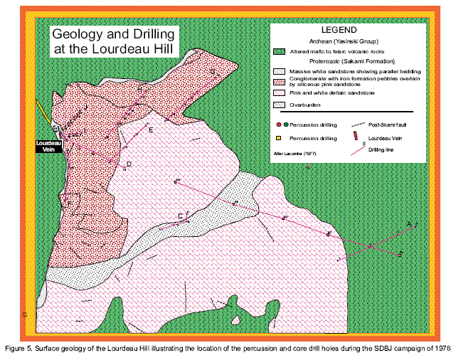
In 1974-1975, SES-SDBJ recognized a regional N140o-oriented fault along the La Grande River which was associated in some places with radiometric values greater than 1,000 cps. A follow-up prospection by helicopter identified an anomalous radiometric zone in argillaceous sediments north of the Lourdeau Hill. Later that year, geologists discovered a boulder train of Sakami Formation sandstones resting at the northern base of the hill. The boulder contained yellow and green impregnations in fractures later identified as autunite, malachite and chalcocite. A clearing of the hill summit later allowed the recognition of a network of N125oE - oriented fractures through a lenticular layer of sericitic siltstone. The uranium mineralization was associated to this layer, whilst the copper impregnated the surrounding sandstone. This discovery sparked a systematic exploration campaign by the SES-SDBJ throughout 1976 and 1977. The campaign included ground prospection along grids, ground-based radiometric, mag and VLF surveys, rock and soil sampling and ultimately percussion and core drilling (see Schumacher and Foulques, 1979, Lacombe, 1977 and Gueniot, 1977).
Geophysical Surveys
Results from the MRNFQ survey indicate that the Lourdeau Hill is located on a rotated block oriented parallel to a N140o dextral fault related to Archean tectonic movements. The airborne CANIICO-SDBJ survey found a conductive zone corresponding to a large depression limiting the Lourdeau Hill to the east.
The 1976 ground-based survey undertaken by the SDBJ helped defined the position of the magnetic and non-magnetic rock assemblages within the Archean basement relative to the tectonic structure and the Sakami Formation outcrops (Gueniot, 1977). The survey also indicated that the thickness of the Sakami Formation increases regularly from the southwest to the northeast.
The ground-based radiometric survey identified three main zones of interest, the most important being the Lourdeau Vein (Figure 5). A secondary zone at the northern end of the hill carried high radiometric values associated with a porous pink sandstone at the contact with gray and white quartz arenite (Gueniot, 1977). Finally, south of the Lourdeau Hill, a contact between sercitic silt zone and an argillaceous (kaolin) white sandstone was discovered to have high radiometric values attributed to elevated Th concentrations.
19
Geochemical Surveys
Grab and channel Sampling
Samples taken form channel cutting perpendicular to the fracture zone at the Lourdeau Vein site were semi-quantitatively analyzed for U, Th, Cu, Pb, Zr, Ni, Co, Mo and V (Gueniot, 1977). The author recognizes that these chemical analyses are not compliant with NI43-101 standards, since the method of sampling and analyses were not described by Gueniot (1977). Therefore, one must take these geochemical results only as a broad indicator of the mineralization found at the Lourdeau Vein site. Gueniot (1979) interpreted the data as an indication that Cu migrated in the pink sandstone from the zones of fracture. He also identified geodes of bornite and chalcopyrite in sandstones surrounding the mylonitic zone. The zone limited by the fractures was shown to have elevated concentrations in Pb, Mo, V, Cu, Ti, Cr, Fe, Th and U. The elevated total iron values correspond the hematization of the sandstone.
The most recent chemical assays from the Lourdeau Vein come from Goutier et al. (2001b) who cites values of 200 ppm U, 0.82% Cu and 1.2 g/t Ag (sample 199922413) and 0.15% U and 461 ppm Cu (sample 199922424) on selected grab samples (Table 2). The results from the chemical assays on quartz arenites seem to confirm the elevated U and Cu concentrations and somewhat high values in Fe and V as cited by Gueniot (1977).
Soil samples
A broad survey covering the Lourdeau Hill and surrounding areas lead to the discovery of a large band of U-anomalous soils oriented N130oE and parallel to the La Grande River. A more detailed survey
20
conducted on a 15 m spaced grid targeted the outcrop zones by sampling principally the A and C soil horizons for Cu and U (Gueniot, 1977). Unsurprisingly, the Lourdeau Vein showed high anomalous Cu (greater than 100 ppm) and U (greater than 3 ppm) concentrations. The survey also detected anomalous Cu and Au values along a depression in the Lourdeau Hill corresponding to a transversal fault. Another Cu-anomalous trend strikes N120oE. Finally, at the bottom of Lourdeau Hill, toward the shoal of the La Grande River, a depression filled by clays showed N120oE-oriented bands of anomalous Cu and U values. Notice that this region is now underwater, filled by the LG-3 Reservoir.
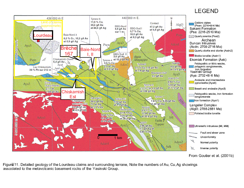
Archean Chiskamish-est, Brèche 167 and Baie - Nord I and II Showings
Geophysical and Geochemical Surveys and Geological Mapping
In 1994, a ground-based mag and electromagnetic survey was conducted by G.L. Géoservice Inc. on a block of claims detained by Hemlo Gold Ltd. The survey determined numerous conductors associated with Au-bearing iron formation (Lamothe, 1992). An airborne mag and E.M. survey was later carried on the same area on a series of claims detained by Exploration Diabior (Lambert, 1995). Several magnetic folded rock units were identified. Another airborne and E.M. survey, cited in Girard (1996), covered the area occupied by the Brèche 167 showing. Over 100 electromagnetic conductors were found during this survey. Lake and stream sediments collected by the MRNFQ during in the area covered by the survey were reanalyzed for their Au concentrations and over 2000 rock samples analyzed for their common and precious metal contents (Girard, 1996).
Chiskiamish-est
Masson (1996) mapped an area in the vicinity of the Lake Chiskamish corresponding in part to the Chiskamish-est showing. A total of 27 analyses from trenches, grab and channel samples representing mostly an altered iron formation yielded the following results:
Trench #1: 0.82 g/t Au on 3.3 m including 1.1 g/t Au on 2.1 m;
Trench #2 : 0.05 g/t Au on 5.9 m including 0.3 g/t on 0.40m;
Trench #3: 0.48 g/t Au on 8.4 m including 1.4 g/t Au on 1 m; 1.9 g/t Au on 0.5 m and 1.5 g/t Au on 0.5 m.
The best results obtained on channel samples are : 0.8 g/t Au on 0.5 m; 1.6 g/t Au on 0.5; 1.3 g/t Au on 0.5 m and 0.4 g/t Au on 1 m.
Chemical assay results from channel samples collected by Noranda and Sirios produced the following results:
3.8 g/t Au on 2 m inlcuding 6.9 g/t Au on 1m;
1.6 g/t Au on 0.5 m;
0.8 g/t Au on 0.5 m;
0.6 g/t Au on 1 m;
0.8 g/t Au on 3 m including 1 g/t Au on 2.1 m;
0.5 g/t Au on 8.4 m including 1.4 g/t Au on 1 m, 1.9 g/t Au on 0.5 m and 1.5 g/t Au on 0.5 m.
Furthermore 7 grab samples yielded concentrations between 3.1 and 13 g/t Au and 11 others gave values between 0.4 to 1.0 g/t Au. Goutier et al. (2001b) reported concentrations of 1.8 g/t Au and 3.1 % As on a grab sample.
21
Brèche 167
Trench and grab sampling accomplished during the exploration campaign of Girard (1996) produced the following significant results:
0.53g/t Au, 0.53% Cu, 209 g/t Ag; 0.53 g/t Au, 0.65% Cu and 3.7 g/t Ag;
0.8 g/t Au, 1.97% Cu, 11.1 g/t Ag; 0.58 g/t Au, 1.78% Cu, 8.1 g/t Ag on 1.75 m;
0.6 g/t Au, 3.15 % Cu, 10.5 g/t Ag on 0.6 m ; 0.75 g/t Au, 0.86% Cu, 6.2 g/t Ag on 1.6 m; 4.2 g/t Au and 3.68 g/t Au, 0.4% Cu, 5.7 g/t Ag.
Baie-Nord I and II
The exploration campaign undertaken by Desbiens (1996) produced the following significant results
Baie-Nord I
In quartz veins:
2.3 g/t Au and 13.6 g/t Ag ;
3.2 g/t Au and 8.8 g/t Ag;
7.8 g/t Au, 0.1% Cu and 28.9 g/t Ag;
0.5 g/t Au, 0.03% Cu and 6.3 g/t Ag.
Baie-Nord II
In quartz-tourmaline veins:
2.3 g/t Au, 5.6% Cu and 32.6 g/t Ag.
In pillow selvages:
1.4 g/t Au, 0.4% Cu and 8.1 g/t Ag on 2 m including 2.3 g/t Au;
0.5% Cu,12.7 g/t Ag on 1 m
Drilling
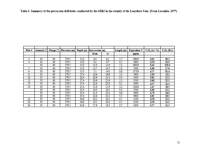
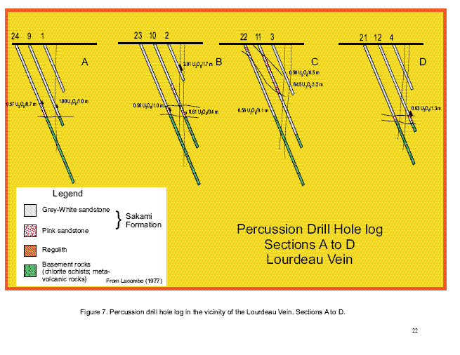
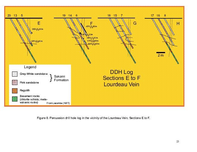
The Lourdeau Property
A series 79 percussion and core drill holes totaling 2.9 miles (4.66 kilometers) were conducted on the Lourdeau Hill on the different targets delimited from the previous exploration work (Gueniot, 1977). The Lourdeau Vein constituted the main drilling target. 25 short percussion holes plunging 60o and established on 5 m spaced grid were initially drilled accompanied by four other holes on a 32 feet (10 meters) spaced grid to study the western extent of the mineralization (Table 3 and Figures 6,7 and 8). Another series of 23 short drill holes were conducted away from the Lourdeau Vein zone in order to find mineralization at the Archean basement/Sakami Formation contact and at the main fault zones (N30oE and N150oE) intersecting the basement and Sakami sandstones (Figures 5 and 9). Finally, 5 core drill holes were realized on the eastern butte of the Lourdeau Hill to intersect the Archean basement and better constrain the tectonic framework (Figure 5).
22
A radiometric logging was accomplished with a Mount Sopris 2500 probe for the medium depth drill holes, whilst a ST22-2T probe was utilized on the shorter holes. The latter was calibrated so that 42 cps corresponds to 1% U. The author acknowledge that the U concentrations presented by Lacombe (1977) are not NI 43-101 compliant and are not comparable to concentration values obtained by chemical assaying. Therefore, the quoted concentrations must be taken as an indication of the potential mineralization.
A close examination of the drill sections reveals the mineralization to be largely confined to a filled zone associated with the main N125oE-oriented fractures. Out of the 25 percussion drill holes conducted on the Lourdeau Vein site, 12 showed interesting values (Table 3 and Figures 7 and 8), 1 showed an isolated radioactive peak.
On the B cross-section (Figure 7), hole number 2 shows U mineralization in the fault zone, whilst the surface counts on a SPP-2 scintillometer is only 100 cps. The F cross-section reveals the most interesting mineralization, especially in hole number 6, which corresponds to a surface anomaly of 15,000 cps (Figure 8). Holes number 5 and 14 in cross-section E show a weak mineralization although on the surface counts of 15,000 cps are observed (Figure 8). It thus appears that the mineralization is largely confined in the fault zone commonly in the top 39 feet (12 meters) of the surrounding white-gray sandstones. At the base of the Sakami Formation, in the fault zone, a weak mineralization is present (holes number 9, 10, 12 and 14, cross-sections A, B, D and F). However, some mineralization also occurs at the base of the sandstones outside the fault zone (holes number 22, 23 and 24; cross sections C, B and A) (Figure 7). Note that most of the mineralization located near the base of the sandstone column appears at a boundary where the color of the sandstones changes from pinkish (oxidizing front) to whitish-gray (reducing front).
Outside the main Lourdeau Vein site, the radiographic logging by the ST2-2T probe did not find any significant increase in the radiometric counts at the base of the sandstone column nor at the intersection with the fault zones. Note however that the gray-white sandstone overlying the conglomeratic quartz and quartz-hematite clasts layer shows in general an increase in radiometric counts unique to this horizon.
Non NI 43-101 compliant U3O8 lb/t concentrations are extrapolated form diagraphic results from the boreholes related to the SES-SDBJ drilling campaign undertaken in the 1970's (Lacombe, 1977) (Table 3). The best intersections obtained from drilling campaign are provided by intersecting the main N125oE fault zone. These are:
Hole number 2 : 3.3 lb/t U3O8 on 5.5 feet (1.7 meters);
Hole number 3 : 7 lb/t U3O8 on 1.6 feet (0.5 meter);
Hole number 5 : 1.0 lb/t U3O8 on 3.2 feet (1 meter);
Hole number 6 : 5.1 lb/t U3O8 on 29 feet (8.9 meters);
Hole number 9 : 1 lb/t U3O8 on 3.2 feet (1 meter); and
Hole number 14 : 2.7 lb/t U3O8 on 7.5 feet (2.3 meters).
The Chiskamisk-est showing
Only one drill hole was performed on the Chiskamisk-est showing (Desbiens, 1997). The hole intersected altered mafic metavolcanic rock, gabbro and iron formation. A section of the ankeritized metavolcanic rocks contained 5-10% bornite and yielded concentrations of 2.69% Cu, 8.9 g/t Ag on 1.5 m and 0.55% Cu on 9.0 m. The iron formation contained 182 ppb Au and >1% As on 1 m , 1921 ppb Au and 0.82% As on 1.5 m and 211 ppb Au and > 1% As on 1 m.
23
Table 2. Chemical analyses of mineralized quartz arenites from the Lourdeau Vein. From Goutier et al. (2001b)
|
Sample # |
1999022414* |
1999022413& |
|
|
|
|
|
SiO2 (wt.%) |
73,60 |
91,50 |
|
TiO2 |
0,24 |
0,02 |
|
Al2O3 |
17,10 |
4,78 |
|
FeO |
0,03 |
0,13 |
|
Fe2O3t |
0,79 |
0,32 |
|
MnO |
--- |
--- |
|
MgO |
0,14 |
--- |
|
CaO |
--- |
--- |
|
Na2O |
--- |
--- |
|
K2O |
2,38 |
0,86 |
|
P2O5 |
0,05 |
0,01 |
|
S |
0,01 |
0,17 |
|
LOI |
5,31 |
1,82 |
|
|
|
|
|
Ag (ppm) |
0,70 |
1,20 |
|
As |
20 21 |
|
|
Au |
52 |
--- |
|
Ba |
101 |
32 |
|
Bi |
7 |
--- |
|
Ce |
77 |
24 |
|
Cr |
44 |
24 |
|
Cu |
461 |
8200 |
|
La |
39 |
11 |
|
Mo |
195 |
55 |
|
Nb |
18 |
4 |
|
Ni |
13 |
11 |
|
Pb |
289 |
38 |
|
Rb |
22 |
13 |
|
Sb |
6 |
1 |
|
Sc |
13 |
1 |
|
Sr |
204 |
65 |
|
U |
1500 |
220 |
|
V |
634 |
46 |
|
W |
80 |
1 |
|
Y |
8 |
--- |
|
Zn |
7 |
--- |
|
Zr |
136 |
40 |
* Quartz arenite, U yellow products in fractures
& Quartz arenite, disseminated Cu mineralization
24
25
26
27
28

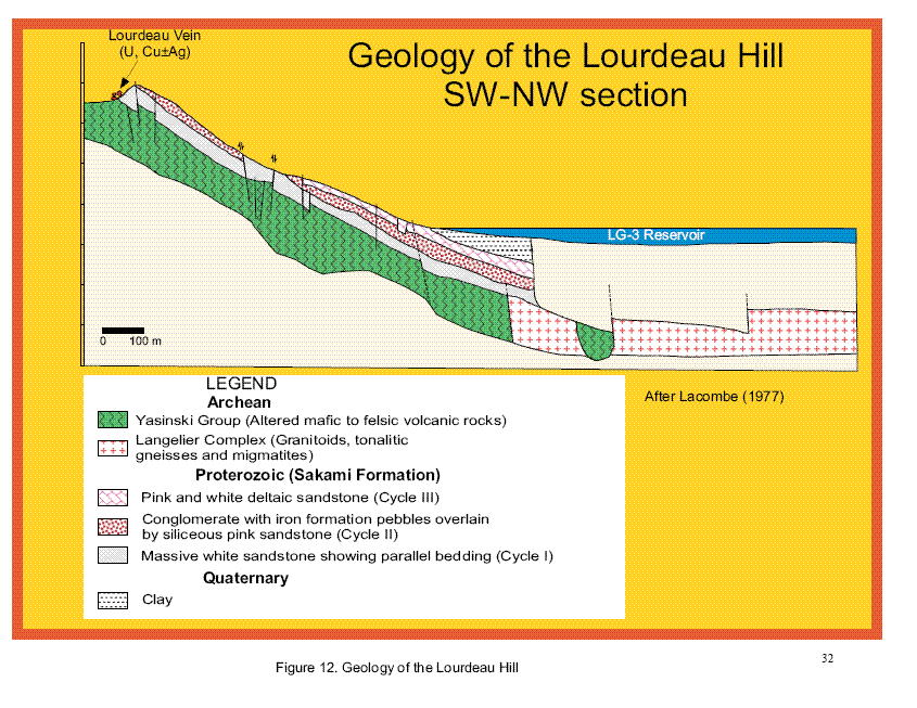
Geology of the Lourdeau Hill
The basement rocks
The basement rocks were only identified by drilling. There are defined by fined-grained folded chloritized schists (mafic volcanic rocks) with quartz, calcite, specularite and chlorite-filled fractures (Lacombe, 1977). The basement shows a dark green color changing to brown-red when irregular patches of hematite are present along micro-fractures. Patches of regolith are very irregular (6.5 to 39 feet or 2 to 12 meters) and composed of greenish-white to yellowish-white sericite, chlorite, quartz, and remnants of chlorite-schists or amphibolite (basaltic volcanic rocks) more or less altered and hematized.
The Sakami Formation
The sandstones of the Lourdeau Hill lies on a uplifted Archean block forming a hill limited by a steep incline to the northwest, southwest and south. The sandstones gently dip east before being engulfed by the waters of the LG-3 Reservoir (Figure 12). The thickness of the Sakami Formation increases rapidly towards the south and east. This augmentation is mainly controlled by fault zones oriented N150oE, N30oE and N70oE. The contact with the Archean basement composed of altered amphibolites is not observed.
Lacombe (1977) recognized three cycles within the exposed Sakami Formation (Figures 12 and 13). These cycles are included within the Psa2 unit as defined by Goutier et al. (2001b). The basal cycle (Cycle I) is characterized by white, massive beds of sandstone, some argillaceous, showing ill-defined parallel bedding and containing argillaceous nodules. Petrographic examination under thin sections
29
indicated that the sandstones are formed by argillaceous-coated quartz grains, sometimes cemented by secondary hematite. No feldspar was observed and was probably destroyed before the deposition of sandstones The upper segment of cycle is marked by a layer of conglomerate with quartz clasts. The thickness of the first cycle could be over 65 feet (20 meters). On a regional scale, the 1976 drilling campaign carried out by the SDBJ (Lacombe, 1977) revealed that Cycle I consists of a series of coarse, heterogranular, pinkyellow to red-brown sandstone beds (59 to 82 feet or 18 to 25 meters) with an abundant kaolinitic, hematitic or argillaceous cement. Thin layers of red-brown siltsone with dispersed quartz, mudstone, sandstone, and rare basement rock cobbles are frequently observed at the base of the stratigraphic column. The sandstones are poorly sorted and form dm to m-sized beds.
The middle cycle (Cycle II) is transitional and starts with a massive bed of pink arenite with, at its base, a layer of conglomerate with iron formation and quartz clasts. Observations from the drill holes cores and cuttings indicate a layer of angular cobble conglomerate (3.2 to 16 feet or 1 to 5 meters) composed of quartz, quartz-hematite (probably iron formation), chlorite schist and sandstone supported in a sandstone matrix and cemented with hematite and quartz. This conglomerate commonly fills ravine and desiccation fractures in the underlying sandstone. The pink arenitic sandstone is overlain by 9.8 to 16 feet (3 to 5 meters) of massive white quartz-rich sandstone portrayed by a mauve-pink reflection. To the north and west, toward the center of the Sakami basin, the thickness of Cycle II may be more important and characterized by an alternance of pink and white sandstones.
The third cycle is the most important. The beds of pink quartz-rich sandstone are defined by planar erosional surfaces. From the base to the summit, we observe: 1) pink, quartz-rich, 2 to 20 inches (5 to 50 centimeters) beds of sandstone with massive, planar stratification showing reverse graded bedding. The base is constituted by fined- to medium-grained sandstone well-cemented by silica and hematite; whilst the summit is formed by porous, coarse-grained and poorly-cemented white sandstone; 2) poorly cemented layers of coarse-grained, cross-bedded sandstone showing alteration in nodules and 3), braded, 16 to 49 feet or 5 to 15 meters thick beds of sandstone. The direction of sediment transport is roughly EW for the first two cycles. There are two direction of transport for the third cycle. The first direction coincides with the principal orientations of the tectonic grain within the La Grande Greenstone Belt and the second is oriented 120o parallel to the structures limiting the occurrences of the Sakami sandstones.
The white massive argillaceous sandstone beds of Cycle I correspond to a first episode of clastic sediments after an hypothetical basal conglomerate formation overlying sericite-rich beds. They may correspond to shallow-depth deposits in a deltaic or near-fluviatile environment. The presence of conglomerates at the end of Cycle I could signify a high-energy emergence period. Indeed, at the end of the first Cycle, silt layers or lenses and yellow-green sericite are filling the exposed joints. The Cycle II sandstones do not extend to the entire Sakami basin. The beds are homogeneous, well-sorted with very little argillaceous material. It is probable that the sedimentation occurred at greater depth with strong currents at its base and summit. The third cycle is transgressive and corresponds to lower energy, deeper deltaic braded sediments
The Sakami sandstones underwent several episodes of diagenetic and epigenetic silicification. A pink diagenitic silicification coinciding with sandstone deposition lead to the filling of reticulated fractures in the white sandstone. The silicification is well observed on the sandstone cliffs and takes a characteristic mauve color. An epigenetic, fracture-filling, white silicification event superposed on the former, is localized and accompanied by quartz breccias.
The Lourdeau Hill forms an eastwest-oriented elevated block, tipped to toward the east and surrounded to the north, south and east by small eastwest-, N130oE- and N60oE- oriented grabens. The outcrops of the Sakami Formation are delimited by well-defined faults and a 30o oriented fault divides the Loudeau Hill in two small buttes: western and eastern. The movement along these faults is of decameter size. The various sandstones blocks limited by these faults appear to show a regular staircase collapse. In the drill cores and cuttings, the faults are recognized by the intense crushing, silicification and hematization.
30
Three types of fracturation were observed: a syn-sedimendary network of fractures related to the deformation of the paleotopography of the depositional surfaces and by the deformation in the layout of the sedimentary beds. The latter is seen as small collapsed sections forming depressions filled by coarser-grained sediments. This type of structure was observed only in the lower part of the Sakami Formation particularly between the white-pink sandstone transition. The synsedimentary movements correspond to collapsed or tilted blocks. Syn-diagenetic fractures generated ductile deformation and disturbed the layout of the sedimentary beds. Finally, small amplitude (16 to 32 feet or 5-10 meters), post-sedimentary faulting produced a general tipping toward the east. The post-sedimentary tectonic movements followed those occurring during the deposition. The block rotation is dextral and occurred along two axes oriented N20oE and N100o to N120oE.
31
32
33
34

35
Conclusions and Recommendations
The Lourdeau property, notably the U, Cu+/-Ag unconformity showing associated to Mid-Proterozoic siliciclastic sediments, represents one of the prime target of exploration in the James Bay Territory of Quebec. The main uranium showing, the Lourdeau Vein, holds a significant potential for a high-grade U mineralization. It is associated to a N125E-oriented fracture zone crosscutting the contact between white argillaceous sandstones and quartz-rich pink sandstones. The mineralization is characterized by U- yellow products in micro-fractures whilst the Cu is found in chrysocolle and bornite-chalcopyrite. Short percussion drill holes exploring the fracture zone were carried by the SES-SDBJ in the late 1970' and produced interesting U values extrapolated from radiometric downhole measurement such as : 3.3 lb/t U3O8 on 1.7 m, 7 lb/t U3O8 on 0.5 m, 5.1 lb/t U3O8 on 8.9 m and 2.7 lb/t U3O8 on 2.3 m (Lacombe, 1977). As an added value to the property, the Archean basement rocks unconformably underlying the U-mineralized Sakami Formation, exposes at least three showings mineralized in Au, Cu and Ag: Chiskamish-est, Baie-Nord I and II and Brèche 167. The Chiskamish-est Au mineralization is associated with quartz veins, silicified zones or longitudinal or transversal shear zones, in an iron formation. Assay results reported by Desbiens (1996) varied between 0.8 to 13 g/t Au. The Baie-Nord I and II showings presents a vein-type mineralization characterized by a Cu-Ag+/-Au+/-Mo metallic association. Significant assay results reported by Desbiens (1996) produced values of 7.8 g/t Au, 0.1% Cu and 28.9 g/t Ag and 2.3 g/t Au, 5.6% Cu and 32.6 g/t Ag. The Brèche 167 showing consists of pods of chalcopyrite disseminated within metagreywacke and metabasalt and generally associated with strongly epidotized rocks, hematized fractures, quartz-carbonate veins and chloritized shear zones. Trench and grab sampling produced the following significant assay results: 0.58 g/t Au, 1.78% Cu; 8.1 g/t Ag on 1.75 m and 0.75 g/t Au, 0.86% Cu, 6.2 g/t Ag on 1.6 m and 4.2 g/t Au. Girard (1996).
Present Work Program
Other than latest worked reported in Michel Boily's technical report dated August 2007, no work has been done on the property. Since our incorporation in 2006, we have incurred an aggregate of $45,260 and issued 75,000 shares in connection with property acquisition cost and $0 in exploration costs. Since our acquisition of the property, there has been no current exploration work performed on the property.
The centre of the Lordeau property is a little over 6 kilometers or 3.7 miles east-southeast from the Hydro-Quebec's settlement at Sakami. Further, parts of these claims are located on the shore of the LG-3 Reservoir. A power line lies approximately 5 kilometers or 3 miles west of the property and a road lies approximately 3 kilometers or 1.8 miles west of the property. Our main source of power and water will be as permitted by Hydro-Quebec.
We are attempting to raise additional money, and have not started the exploration program. If we are able to raise additional money, we may pursue the exploration program recommended by Mr. Boily on the Lourdeau property in the coming year. One of the major incentive for doing so is the favorable geological environment for defining a potential uranium unconformity associated deposit. One of the main challenge resides in confirming the radiometric extrapolated U3O8 values obtained from percussion drilling into NI 43-101 compliant chemical assays. The proposed "classical" petrogenetic model applied to the Lourdeau showing from the studies of the deposits discovered in the Athabasca Basin in Saskatchewan (Jefferson et al., 1996; Ruzicka, 1996 and Hoeve and Sibbald, 1978) also needs to be confirmed. As an added value, the Lourdeau property exhibits three showings mineralized in Au, Ag and Cu within the volcanic basement rocks. While the mineralization at these sites appears erratically distributed, it covers a comparatively large area along the northern shore of the LG-3 Reservoir.
The following exploration program is recommended by Mr. Boily:
In order to get a solid geochemical assay database, we propose a systematic surface sampling program of the Lourdeau Vein site and its vicinity incorporating grab and channel sampling. A second site discovered by scintillometer prospecting (Lacombe, 1977) at the northern edge of the Lourdeau Hill needs to be sampled. The radiometric anomaly is located within the hematitequartz clasts conglomerate
36
at the contact with the red and pink Sakami Fm. sandstones. The sampling will also allow us to decipher the nature and composition of the U-carrier minerals by bringing specific specimens to the SEM lab.
The Lourdeau Hill exposes only an area of 1 km2 of Sakami sandstone with the property covering nearly 9km2. Therefore only helicopter-borne geophysical surveys are viable economically. We will thus undertake magnetic and radiometric surveys on a 100 m spaced grid. The magnetic survey will help provide a high-resolution profile of the basement rocks under the Sakami Formation, whilst the radiometric survey will detect the potential radioactive zones. We will beneficiate from the newest survey techniques that were not available in the 1970's. The magnetic survey will also cover the Archean metavolcanic terranes, which constitute the basement rocks of the Sakami Fm, but more interestingly, display several Au and sulphide-rich target, notably the iron formations that are highly responsive to this type of survey.
Contingent on positive results obtained during this program, we could proceed with a drilling campaign which would define the targets acquired during the geophysical surveys and sampling campaign. The focus of the drilling will be the U-mineralized sandstones at the Lourdeau Hill, with the Au, Cu and Ag-mineralized metavolcanic constituting secondary targets.
PART IV
ITEM 15. EXHIBITS, FINANCIAL STATEMENT SCHEDULES
Financial Statements and Schedules
The financial statements are set forth under Item 8 of the Report on Form 10-K filed with the SEC on May 28, 2010. Financial statement schedules have been omitted since they are either not required, not applicable, or the information is otherwise included.
Exhibit Listing
|
|
|
|
Incorporated by reference |
||
|
Exhibit No. |
Description of Exhibit |
Filed herewith |
Form |
Exhibit |
Filing
date |
|
3.1 |
Articles of Incorporation |
|
S-1 |
3.1 |
07/14/08 |
|
3.1 |
Bylaws |
|
S-1 |
3.2 |
07/14/08 |
|
4.1 |
Specimen Stock Certificate |
|
S-1 |
3.2 |
07/14/08 |
|
10.1 |
Mineral Property Option Agreement dated June 25, 2007 between Starfire Minerals Inc. and Santos Resource Corp., whereby Santos has an option to acquire a 75% interest in and to the Lourdeau Property |
|
S-1 |
10.1 |
07/14/08 |
|
10.2 |
Mineral Property Option Amending Agreement dated May 29, 2008 between Starfire Minerals Inc. and Santos Resource Corp. |
|
S-1 |
10.2 |
11/26/08 |
|
10.3 |
Mineral Property Option Agreement Amendment No. 2 dated April 23, 2009 between Starfire Minerals Inc. and Santos Resource Corp. |
|
10-K |
10.3 |
05/27/09 |
|
10.4 |
Mineral Property Option Amending Agreement (third amendment) dated April 26, 2010 between Starfire Minerals Inc. and Santos Resource Corp. |
|
8-K |
10.4 |
04/30/10 |
|
14 |
Code of Ethics |
|
S-1 |
14 |
07/14/08 |
37
|
|
|
|
Incorporated by reference |
||
|
Exhibit No. |
Description of Exhibit |
Filed herewith |
Form |
Exhibit |
Filing
date |
|
31.1 |
Certifications of Principal Executive Officer and Principal Financial Officer Pursuant to Section 302 of the Sarbanes-Oxley Act of 2002 |
X |
|
|
|
|
32.1 |
Certifications of Principal Executive Officer and Principal Financial Officer Pursuant to Section 906 of the Sarbanes-Oxley Act of 2002 |
X |
|
|
|
38
SIGNATURES
Pursuant to the requirements of Section 13 or 15(d) of the Securities Exchange Act of 1934, the Registrant has duly caused this report to be signed on its behalf by the undersigned; thereunto duly authorized.
|
SANTOS RESOURCE CORP. |
|
|
|
|
Pursuant to the requirements of the Securities Exchange Act of 1934, this report has been signed below by the following persons on behalf of Registrant and in the capacities indicated on the dates indicated.
|
Date |
Signature |
Title |
|
|
|
|
|
|
|
|