Attached files
| file | filename |
|---|---|
| EX-31.2 - CERTIFICATION - Lake Victoria Mining Company, Inc. | exhibit31-2.htm |
| EX-21.1 - LIST OF SUBSIDIARIES - Lake Victoria Mining Company, Inc. | exhibit21-1.htm |
| EX-31.1 - CERTIFICATION - Lake Victoria Mining Company, Inc. | exhibit31-1.htm |
| EX-32.1 - CERTIFICATION - Lake Victoria Mining Company, Inc. | exhibit32-1.htm |
| EX-32.2 - CERTIFICATION - Lake Victoria Mining Company, Inc. | exhibit32-2.htm |
UNITED STATES
SECURITIES AND EXCHANGE COMMISSION
Washington, D.C. 20549
FORM 10-K /A
(Amendment No.
1)
[X] ANNUAL REPORT UNDER TO SECTION 13 OR 15(d) OF THE SECURITIES EXCHANGE ACT OF 1934 FOR THE YEAR ENDED MARCH 31, 2010
or
[ ] TRANSITION REPORT UNDER SECTION 13 OR 15(d) OF THE EXCHANGE ACT
For the transition period from ________________ to __________________
Commission file number 000-53291
LAKE VICTORIA MINING COMPANY,
INC.
(Exact name of registrant as specified in its charter)
NEVADA
(State or other jurisdiction
of incorporation or organization)
1781 Larkspur Drive
Golden, Colorado 80401
(Address of principal executive offices, including zip code.)
(303) 586-1390
(telephone number, including area code)
Indicate by check mark if the registrant is a well-known
seasoned issuer, as defined in Rule 405 of the Securities Act.
YES
[ ] NO [X]
Indicate by check mark if the registrant is not required to file
reports pursuant to Section 13 or 15(d) of the Act:
YES [
] NO [X]
Indicate by checkmark whether the registrant has submitted
electronically and posted on its corporate Website, if any, every Interactive
Data File required to be submitted and posted pursuant to Rule405 of Regulation
S-T (* 229.405 of this chapter) during the preceding 12 months (or for such
shorter period that the registrant was required to submit and post such files).
YES [X] NO [ ]
Indicate by check mark whether the registrant(1) has filed all
reports required by Section 13 or 15(d) of the Securities Exchange Act of 1934
during the preceding 12 months (or for such shorter period that the registrant
was required to file such reports), and (2) has been subject to such filing
requirements for the past 90 day.
YES [X] NO
[ ]
Indicate by check mark if disclosure of delinquent filers pursuant to Item 405 of Regulations S-K is not contained herein, and will not be contained, to the best of registrant’s knowledge, in definitive proxy or information statements incorporated by reference in Part III of this Form 10-K or any amendment to this Form 10-K. [ ]
Indicate by check mark whether the registrant is a large accelerated filer, an accelerated filer, a non-accelerated filer, or a smaller reporting company. See the definitions of “large accelerated filer,” “accelerated filer” and “smaller reporting company” in Rule 12b-2 if the Exchange Act.
| Large Accelerated Filer [ ] | Accelerated Filer [ ] |
| Non-accelerated Filer [ ] | Smaller Reporting Company [X] |
| (Do not check if a smaller reporting company) |
Indicate by check mark whether the registrant is a shell company
(as defined in Rule 12b-2 of the Act).
YES [
] NO [X]
State the aggregate market value of the voting and non-voting common equity held by non-affiliates computed by reference to the price at which the common equity was sold, or the average bid and asked price of such common equity, as of July 13, 2009 was $0.25.
Indicate the number of shares outstanding of each of the registrant's classes of common stock as of the latest practicable date, as of July 13, 2010, total outstanding common shares was 71,239,100.
EXPLANATORY NOTE
This Amendment No. 1 (the “Amendment”) to the annual report on Form 10-K for the fiscal year ended March 31, 2010, of Lake Victoria Mining Company, Inc. (the “Company”) which was originally filed with the Securities and Exchange Commission on July 14, 2010 (the “Original Filing”) is being filed for the following purposes:
-
to amend the consolidated statements of operations and the consolidated statements of cash flows included in the Company's audited financial statements with respect to the mineral property acquisition costs and make certain amendments to the notes to the audited financial statements with respect to the mineral properties accounting policy;
to amend the disclosure under “Item 2. Properties” to include additional disclosure regarding the Company’s mineral properties to comply with Item 102 of Regulation S-K;
-
to include certain disclosure regarding sales of equity securities during the reporting period that were not previously disclosed in accordance with Regulation S-K;
-
to include additional disclosure regarding management and director compensation during the fiscal year ended March 31, 2010 under "Item 11. Executive Compensation" to comply with Item 402 of Regulation S-K;
-
to amend Item 13. Certain Relationships and Related Transactions, and Director Independence to comply with Item 404 of Regulation S-K; and
-
to provide a list of subsidiaries of the Company as an exhibit to the Form 10-K.
Other than as expressly set forth above, this Amendment does not, and does not purport to, update or restate the information in any Item of the Original Filing or reflect any events that have occurred after the Original Filing was filed. The filing of this Amendment shall not be deemed an admission that the Form 10-K, when made, included any known, untrue statement of material fact or knowingly omitted to state a material fact necessary to make a statement not misleading.
TABLE OF CONTENTS
-2-
PART I.
ITEM 1. BUSINESS.
Lake Victoria Mining Company, Inc. (formerly known as Kilimanjaro Mining Company, Inc.) was incorporated on December 11, 2006 under the laws of the State of Nevada. We are an exploration stage corporation. An exploration stage corporation is one engaged in the search for mineral deposits or reserves which are not in either the development or production stage. We intend to conduct mineral exploration activities on properties to find an economic mineral body containing gold. Effective September 30, 2008, we were no longer a shell company. We maintain our statutory registered agent’s office at The Corporation Trust Company of Nevada, 6100 Neil Road, Suite 500, Reno, Nevada 89511 and our business and administrative office is located at 1781 Larkspur Drive, Golden, Colorado 80401. This is our mailing address as well. Our telephone number is (303) 586-1390. Roger Newell, our president, supplies this office space on a rent-free basis. Throughout the notes to the consolidated financial statements the term “Company” refers to the consolidated combined financial information and activities of Kilimanjaro Mining Company, Inc. (“Kilimanjaro”) and its previously reporting subsidiary Lake Victoria Mining Company, Inc. (“Lake Victoria”). The Company is also referred to as “we”, “us” and “our”.
Business
The principal business of the Company both as previously reported and as restructured through the share exchange of July 8, 2009, as described below, is to search for mineral deposits or reserves which are not in either the development or production stage. The Company is an exploration stage corporation that is conducting exploration activities primarily on prospective gold properties that are located in the United Republic of Tanzania, East Africa. We are exploring our properties by conducting an extensive program of mapping geology, sampling soils and rocks, assaying the samples for gold, geophysical surveying and drilling to identify faults and other geologic structures that might be helping to control the location of important gold values.
On May 4, 2009, Kilimanjaro completed a Property Acquisition Agreement with Geo Can Resources Company Limited (“Geo Can”) a company incorporated in the United Republic of Tanzania, East Africa. Geo Can is based in Tanzania and has a common director to the Company. Geo Can has been involved in the identification, acquisition and exploration of mineral resource properties in Tanzania for more than three years and had accumulated a large desirable property portfolio. In addition it supplies contract exploration services within Tanzania for other companies. Under the terms of the May 4, 2009 agreement, Kilimanjaro acquired 100% interests of the mineral property assets of Geo Can, which included 33 gold prospecting licenses and 13 uranium licenses. Geo Can had entered into property option agreements, regarding some of these resource properties, with Lake Victoria before the Property Acquisition Agreement with Kilimanjaro, but, as a consequence of the May 4, 2009 agreement, Geo Can no longer has any interest in those prior property agreements.
On July 8, 2009, Kilimanjaro Mining Company, Inc. and Lake Victoria Mining Company, Inc. entered into a Securities Exchange Agreement (the “acquisition”) under which Lake Victoria acquired all of the issued and outstanding common shares of Kilimanjaro. Prior to the acquisition, Lake Victoria was a registrant with the Securities and Exchange Commission and a consolidated subsidiary of Kilimanjaro. Kilimanjaro and Lake Victoria had been under common control since each of the entities’ inception. The acquisition was completed on August 7, 2009 and the stockholders of Kilimanjaro received approximately 67% of the Company’s issued capital shares. The acquisition was accounted for as a “reverse acquisition restructuring” and recapitalization of Kilimanjaro. As the result of this transfer, the former stockholders of Kilimanjaro owned a majority of the outstanding shares of the common stock of the Company, and Kilimanjaro was treated as the accounting acquirer for financial statement purposes. Since Lake Victoria was a consolidated subsidiary of Kilimanjaro, all of the historical accounting information previously reported by the registrant is incorporated in the historical financial information of the Company’s consolidated financial statements. Accordingly, the two entities consolidation reflects all of the historical financial information without any modification for recognition of fair value adjustments based upon a
-3-
business combination. The equity of Kilimanjaro for accounting purposes was restated in the legal framework of its previously controlled subsidiary Lake Victoria. The continuing legal entity is Lake Victoria Mining Company, Inc. and all equity information has been restated under its share structure and the continuing accounting of the consolidated results of operations are based upon Kilimanjaro’s consolidation of financial information from inception.
In November 2009, to perform our ongoing mineral exploration of prospective gold properties, we incorporated, Lake Victoria Resources (T) Limited, a wholly-owned subsidiary in Tanzania.
All of the Company’s mineral property interests are located in the United Republic of Tanzania, East Africa. Geo Can holds the title of the resource properties in trust for Kilimanjaro. Most of our resource property interests are still formally registered to Geo Can to save on registration fees. When the annual filing for each property comes due then the formal registration of each property will be transferred to Kilimanjaro or as directed by Kilimanjaro.
The Company holds a 100% ownership interest in all of the properties that were acquired in the May 4, 2009 Property Acquisition agreement that was completed between Kilimanjaro and Geo Can. The properties are unencumbered and there are no competitive conditions which affect the properties. Further, there is no insurance covering the properties and we believe that no insurance is necessary since at this point the properties are unimproved.
We have no revenues, we have incurred losses since inception, we have been issued a going concern opinion and we have relied upon the sale of our securities to fund operations.
To date, we have not discovered a commercially viable ore body, mineral deposit, or mineral reserve, on any of our properties and we will be unable to do so until further exploration is done and a comprehensive evaluation concludes an economic and legal feasibility study.
Our property portfolio is large, therefore we may interest other companies in our properties to either participate by means of option or joint venture agreements in the exploration of them or to finance and establish production if mineralization is found.
Although our exploration focus during this reporting period was on Kinyambwiga and Singida gold projects, we plan to commence initial exploration on our other gold projects during the upcoming reporting period as we continue to advance Kinyambwiga and Singida. See ITEM 2: Properties, Table 1 and Table 2 for a complete property license list by project, license number area, district and size.
Competitive Factors
The gold mining industry is fragmented, that is there are many gold prospectors and producers, small and large. We are a small exploration stage mining company and we do not have the financial, personnel or equipment resources that many competitors possess. Because of our lack of resources we may not be able to adequately withstand the competitive forces that exist in the mining industry generally and specifically with respect to gold mining.
Regulations
Mineral rights in the United Republic of Tanzania are governed by the Mining Act of 1998, and control over minerals is vested in the United Republic of Tanzania. Prospecting for minerals may only be conducted under authority of a mineral right granted by the Ministry of Energy and Minerals under this Act.
The three types of mineral rights most often encountered, which are applicable to us include: prospecting licenses; retention licenses; and mining licenses. A prospecting license grants the holder thereof the exclusive right to prospect in the area covered by the license for all minerals, other than building and gemstones, for a period of three years.
-4-
Thereafter, the license is renewable for two further periods of two years each. On each renewal of a prospecting license, 50 percent of the area covered by the license must be relinquished. Before application is made for a prospecting license, a prospecting reconnaissance for a maximum area of 5,000 square kilometers is issued for a period of two years after which a three-year prospecting license is applied for. A company applying for a prospecting license must, inter alia, state the financial and technical resources available to it. A retention license can also be requested from the Minister, after the expiry of the 3-2-2-year prospecting license period, for reasons ranging from funds to technical considerations.
Mining is carried out through either a mining license or a special mining license, both of which confer on the holder thereof the exclusive right to conduct mining operations in or on the area covered by the license. A mining license is granted for a period of 10 years and is renewable for a further period of 10 years. A special mining license is granted for a period of 25 years and is renewable for a further period of 25 years. If the holder of a prospecting license has identified a mineral deposit within the prospecting area which is potentially of commercial significance, but it cannot be developed immediately by reason of technical constraints, adverse market conditions or other economic factors of a temporary character, it can apply for a retention license which will entitle the holder thereof to apply for a special mining license when it sees fit to proceed with mining operations.
A retention license is valid for a period of five years and is thereafter renewable for a single period of five years. A mineral right may be freely assigned by the holder thereof to another person, except for a mining license, which must have the approval of the Ministry to be assigned.
However, this approval requirement for the assignment of a mining license will not apply if the mining license is assigned to an affiliate company of the holder or to a financial institution or bank as security for any loan or guarantee in respect of mining operations.
A holder of a mineral right may enter into a development agreement with the Ministry to guarantee the fiscal stability of a long-term mining project and make special provision for the payment of royalties, taxes, fees and other fiscal imposts.
We have complied with all applicable requirements and the relevant licenses have been issued.
Environmental Law
We are also subject to Tanzania laws dealing with environmental matters relating to the exploration and development of mining properties. While in the exploration stage, on any of our project areas, we are conscious of any environmental impact we may be having. However, our obligations are very limited, as our activities cause minimal environmental disturbances and are limited to mapping, sampling, trenching, geophysical surveying and drilling. Once project areas reach a point of being commercially feasible for mining then we will be required to conduct proper environmental impact studies based on feasibility reports and planned mining operations. We do protect the environment through any regulations affecting:
| 1. | Health and Safety |
| 2. | Archaeological Sites |
| 3. | Exploration Access |
Employees
To the extent possible we intend to use the services of subcontractors for manual labor and exploration work on our properties. Lake Victoria Resources (T) Limited, our wholly owned Tanzania subsidiary may hire subcontractors and employees to complete exploration work. A large skilled and unskilled workforce is readily available within Tanzania to satisfy any labour requirements we may have. Through contractors and skilled professional employees the company does provide any necessary on the job training to accomplish our exploration objectives.
-5-
Employees and Employment Agreements
At present, we have no full-time employees. Our two officers and directors will each devote a minimum of about 30 percent of their time to our operation. Our officers and directors do not have employment agreements with us. We presently do not have pension, health, annuity, insurance, stock options, profit sharing or similar benefit plans; however, we may adopt plans in the future. There are presently no personal benefits available to our officers and directors. Our president Roger Newell and secretary Heidi Kalenuik will handle our administrative duties.
ITEM 1A. RISK FACTORS.
We are a smaller reporting company as defined by Rule 12b-2 of the Exchange Act and are not required to provide the information required under this item.
ITEM 1B. UNRESOLVED STAFF COMMENTS.
We are a smaller reporting company as defined by Rule 12b-2 of the Exchange Act and are not required to provide the information required under this item.
ITEM 2. PROPERTIES.
Licenses
The following chart (Table 1) is a complete list of each gold prospecting license that we own by project name, license number, the area of location, district of its location and the size in square kilometers. Table 2, a complete list of our uranium prospect licenses, follows the gold license list (Table 1). We own no prospecting property other than the following licenses listed on Table 1 and 2:
| Table 1: Gold Projects and License List | ||||
| Project | License No | Area | District | Size (SqKm) |
| KALEMELA | ||||
| PL 2747/2004 | Magu | Magu | 34.01 | |
| PL 2910/2004 | Bunda South | Bunda | 37.90 | |
| PL 3006/2005 | Bunda | Bunda | 56.56 | |
| PL 5892/2009 | Magu | Magu | 29.67 | |
| PL 5912/2009 | Magu | Magu | 56.74 | |
| PL 5988/2009 | Bunda South | Magu | 38.92 | |
| 253.80 | ||||
| GEITA | ||||
| PL 2806/2004 | Geita | Geita | 21.59 | |
| PL 5958/2009 | Geita | Geita | 20.85 | |
| 42.44 | ||||
| MUSOMA BUNDA | ||||
| PL 4511/2007 | Masinono | Musoma | 51.90 | |
| PL 3966/2006 | Suguti | Musoma | 72.95 | |
| Kinyambwiga | ||||
| PL 4653/2007 | Kinyambwiga | Musoma | 30.89 | |
| 24 PML's | ||||
| 1)PM0001173 | Kinyambwiga | Musoma | 8.36 Hectares | |
| 2)PM0001174 | Kinyambwiga | Musoma | 8.36 Hectares | |
| 3)PM0001175 | Kinyambwiga | Musoma | 8.36 Hectares | |
-6-
| 4)PM0001176 | Kinyambwiga | Musoma | 8.36 Hectares | |
| 5)PM0001177 | Kinyambwiga | Musoma | 8.36 Hectares | |
| 6)PM0001178 | Kinyambwiga | Musoma | 8.36 Hectares | |
| 7)PM0001179 | Kinyambwiga | Musoma | 8.36 Hectares | |
| 8)PM0001180 | Kinyambwiga | Musoma | 8.36 Hectares | |
| 9)PM0001181 | Kinyambwiga | Musoma | 8.36 Hectares | |
| 10)PM0001182 | Kinyambwiga | Musoma | 8.36 Hectares | |
| 11)PM0001183 | Kinyambwiga | Musoma | 8.36 Hectares | |
| 12)PM0001184 | Kinyambwiga | Musoma | 8.36 Hectares | |
| 13)PM0001185 | Kinyambwiga | Musoma | 8.36 Hectares | |
| 14)PM0001301 | Kinyambwiga | Musoma | 8.36 Hectares | |
| 15)PM0001302 | Kinyambwiga | Musoma | 8.36 Hectares | |
| 16)PM0001307 | Kinyambwiga | Musoma | 8.36 Hectares | |
| 17)PM0004582 | Kinyambwiga | Musoma | 8.36 Hectares | |
| 18)PM0004583 | Kinyambwiga | Musoma | 8.36 Hectares | |
| 19)PM0004584 | Kinyambwiga | Musoma | 8.36 Hectares | |
| 20)PM0004585 | Kinyambwiga | Musoma | 8.36 Hectares | |
| 21)PM0004586 | Kinyambwiga | Musoma | 8.36 Hectares | |
| 22)PM0004587 | Kinyambwiga | Musoma | 8.36 Hectares | |
| 23)PM0004588 | Kinyambwiga | Musoma | 8.36 Hectares | |
| 24)PM0004589 | Kinyambwiga | Musoma | 8.36 Hectares | |
| 155.74 | ||||
| SINGIDA | ||||
| 60 PMLs | 200mx500m | Singida - Londoni | Singida | 6 |
| 6 | ||||
| BUHEMBA | ||||
| PL 2979/2005 | Buhemba | Serengeti | 33.86 | |
| PL 5919/2009 | Buhemba | Serengeti | 34.92 | |
| 68.78 | ||||
| UYOWA | ||||
| PL 4531/2007 | Uyowa | Urambo | 95.12 | |
| PL 3425/2005 | Uyowa | Uyowa | 171.20 | |
| PL 5009/2008/ | Uyowa | Urambo | 244.32 | |
| PL 5916/2009 | Uyowa | Urambo | 49.89 | |
| PL 4749/2007 | Kisimani River and Iseramigas | Urambo | 34.24 | |
| PL 5153/2008 | Uyowa | Uyowa | 134.96 | |
| PL 3557/2005 | Uyowa | Uyowa | 171.10 | |
| 900.83 | ||||
| KAHAMA | ||||
| Kahama Shinyanga | ||||
| PL 3439/2005 | Salawe | Shinyanga | 48.00 | |
| PL 5846/2009 | Mwamazengo | Misungwi | 42.00 | |
| Kahama South | ||||
| PLR 4188/2006 | Kahama South | Kahama | 184.00 | |
| PLR 4189/2006 | Kahama | Kahama | 61.09 | |
| PL 5844/2009 | Urambo | Kahama | 184.09 |
-7-
| 519.18 | ||||
| NORTH MARA | ||||
| Tarime North Mara | ||||
| PL4882/2007 | Tarime | Nyagisa/Tarime | 61.80 | |
| PL3340/2005 | Ikoma | Tarime | 195.50 | |
| PL2677/2004 | Tarime | Tarime | 37.32 | |
| PL3005/2005 | Tarime | Mara Tarime | 85.43 | |
| PL4873/2007 | Tarime | Tarime | 40.97 | |
| PL3341/2005 | Utegi | Tarime | 51.51 | |
| PL3339/2005 | Tarime | Tarime | 3.59 | |
| PL4225/2007 | Kiagata | Musoma | 42.56 | |
| North Mara Nyabigena East | ||||
| PL3355/2005 | Nyamwanga/Nyamongo | Tarime | 24.17 | |
| PL4645/2007 | Tarime | Tarime | 16.90 | |
| Kubaisi-Kiserya | ||||
| PL3338/2005 | Kubaisi | Musoma | 12.53 | |
| PL4833/2007 | Kiterere Hills | Tarime & Serengeti | 27.34 | |
| 599.62 | ||||
| 37 Prospecting Licenses (PLs) - Total SqKm | 2546.39 | |||
| 84 Primary Mining Licenses (PMLs) | ||||
Table 2 – Uranium Projects and License List
| Project | License No | Area | District | Size (SqKm) |
| MBINGA | ||||
| PLR 4433/2007 | Mbinga | Songea | 1,101.00 | |
| PLR 4335/2007 | Litembo | Mbinga | 462.50 | |
| PL 4254/2007 | Pulambili | Mbinga | 197.50 | |
| 1,761.00 | ||||
| KIWIRA | ||||
| PL 4651/2007 | Makete | Makete & Kyela | 173.00 | |
| PL 4406/2007 | Chunya | Mbeya | 101.60 | |
| PL 4514/2007 | Kyela | Kyela | 139.60 | |
| 414.20 | ||||
| NJOMBE | ||||
| PLR 4297/2007 | Njombe | Makete | 282.20 | |
| 282.20 | ||||
| LAKE RUKWA | ||||
| PLR 4068/2007 | Chunya | Mbeya | 268.80 | |
| 268.80 | ||||
| MKUJU EAST | ||||
| PLR 4692/2007 | Madaba | Liwale | 423.50 | |
| PLR 4644/2007 | Madaba North | Liwale and Kilombero | 672.79 | |
-8-
| 1,096.29 | |||
| 10 Prospecting and Reconnaissance Licenses - Total (Sqkm) | 3,822.49 |
PROSPECTIVE PROJECTS AND PROPERTIES
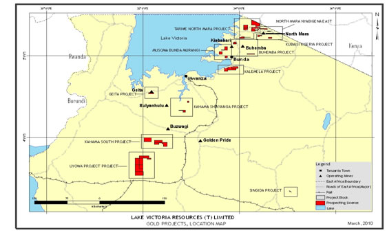
The following map (Map 1) is a gold project location map. The “red” is the outline of all of our individual Prospecting Licenses (PLs) that are combined to make a project area. Our projects are outlined in “blue”. For a detailed listing see Item 2: Properties – Table 1
Map 1: Gold Project Location Map, March 2010
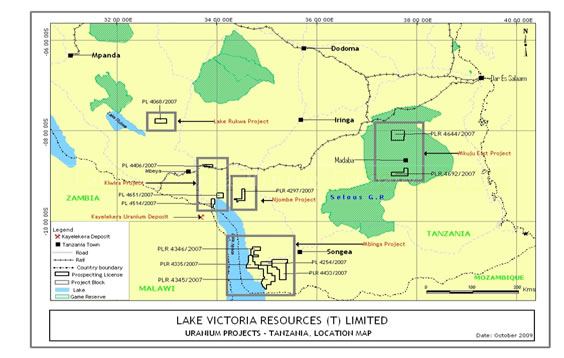
The following map (Map 2) is a uranium project location map. The “black” is the outline of all of our individual Prospecting Licenses (PLs or PLRs) that are combined to make a project. Our projects are outlined in “grey”. For a detailed listing see Item 2: Properties – Table 2
Map 2: Uranium Location Map, March 2010
-9-
Prospective Gold Projects
The following is a brief overview of our portfolio of prospective mineral properties, the exploration developments on them where applicable and some of the details of the historical option agreements for them. During this reporting period all of our exploration work was concentrated on the Kinyambwiga and Singida gold projects.
Kalemela Gold Project
Kalemela project is comprised of PL2747/2004, PL2910/2004, PL3006/2005, PL2892/2009, PL5912/2009 and PL5988/2009 totaling approximately 253.80 sq. km. The first event that occurred, on April 1, 2007, was the acquisition of the prospecting license, PL2747/2004 from Uyowa Gold Mining and Exploration Company Limited, P.O. Box 3167, Dar es Salaam, Tanzania. Kalemela Gold Project license number: PL2747/2004 is located within the Southeastern Lake Victoria Goldfields in Northern Tanzania in Magu District, Mwanza Region and is approximately 125 kilometers northeast of Mwanza. This was followed by a physical examination of the property by Dr. Roger A. Newell, a geologist, our president and director. The license is currently recorded in Geo Can’s name. Following the initial examination, we entered an Exploration Services Agreement with Geo Can to conduct geologic mapping, soil and rock sampling and ground magnetic surveys.
Subsequently, on November 18, 2008 we acquired two adjacent and contiguous licenses PL3006/2005 and PL2910/2004. We expanded our mineral exploration budget with Geo Can to complete a similar initial exploration program that was conducted on PL2747/2004. We have completed the initial exploration of PL3006/2005 and PL2910/2004. The three licenses totaled about 260 square kilometers. Results of geologic mapping, ground magnetic surveying and soil and rock sampling have identified exploration sites suitable for electrical induced polarization (I.P.) geophysical surveys to further define possible drill targets. Depending on available resources and project scheduling, follow up soil sampling will be conducted to confirm previous sampling results, followed by a targeted electrically induced polariztion (I.P.) geophysical survey and a possible initial drill program. No additional work was conducted on the Kalemela project during this reporting period.
Location and Access
-10-
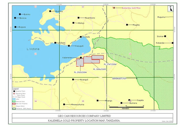
Map 3, “The Kalemela Gold Property Location Map, Tanzania” illustrates the location of the original three Kalemela licenses relative to Lake Victoria, the Serengeti National Park and to each of the other licenses.
The Kalemela Gold Project is located in the Kilimafedha greenstone belt of the Lake Victoria Gold Field in the Magu and Bunda Districts, Mwanza Region of northern Tanzania. The properties can be reached by traveling northeastwards from Mwanza city on the all-weather Mwanza-Magu-Bunda paved highway that continues northwards to Musoma. PL2747/2004 covers a total area of 70.72 square kilometers in quadrangle QDS 23/4. PL2910/2004 covers a total area of 77.20 square kilometers in quadrangle QDS 23/3. PL3006/2005 covers a total area of 113.90 square kilometers in quadrangle QDS 23/4. The original three licenses covered about 261.8 square kilometers and have each been split in half in compliance with the Mining Act of Tanzania. This has resulted in the Kalemela project now being comprised of six (6) PLs with an additional three (3) new PL numbers being assigned and totaling about 253.80 sq. km. However, all the subsequent exploration comments refer to the original three prospecting licenses (PLs)
The properties are near the eastern tip of Lake Victoria’s Speke Gulf and close to the southern shoreline of Lake Victoria. The nearest airport with regularly scheduled flights is in Musoma although the Mwanza airport is preferred where there are daily flights to and from Dar es Salaam and Kilimanjaro international airports.
Map 3: Kalemela Gold Project Location Map, December 2008
The city of Musoma has a population of about 1.5 million and a well-developed social and commercial infrastructure including: transportation, telecommunications, educational institutes, hospitals, hotels, and recreational facilities. The licenses are approximately 86 kilometers south of Musoma. Bunda, a closer, smaller commercial center than Musoma, is only about 36 kilometers north of the project area.
Road access to the licenses from Musoma, the nearest large town, is to Lamadi village over a well maintained paved highway, and then by dirt roads to all parts of the project. Two wheel vehicles are satisfactory in the dry season, but four wheel drive vehicles are required during the wet season.
-11-
Physiography and Climate
Topographically, the license consists of sweeping terrain, with several low hills in the southern and eastern parts; flat stretches of grass and dark colored clay rich mbuga soils dominate the central and northern parts of the license. The most conspicuous topographic features in the area surrounding the project are two large hills known as Ngasamo Hill and Wamangola Hill. These two hills lie south of the project and are formed by iron and magnesium rich intrusive rocks.
The project is located at the western fringe of the Kilimafedha greenstone belt. Granitoid and greenstone rocks extend northward to the Ndabaka Plains and to the Serengeti Game Reserve. The licenses constitute the northern extremity of a large and physiographically mature area known as Sukumaland. The area is adequately drained by the northwest flowing Lutubiga stream together with various other tributaries to the generally east flowing Ramadi River. All rivers in the area flow into the Duma River that eventually empties into Lake Victoria. The drainage channels are structurally controlled and follow joints, shear zones and other internal structures in the underlying bedrock. Outcrops are generally scarce as much of the area is covered with extensive amounts of Recent clay rich soils.
Geology
The most significant regional structural feature is the northwest trending Suguti Shear Zone, which is located about 25 kilometers to the northeast. This structure lies within a broad, 2-3 kilometer wide depression; smaller faults within our properties are believed to represent offshoots from the larger Suguti structure. It may be possible that these small faults have helped to control the location of elevated metal values.
Greenstone volcanic rocks and granite rocks are the major lithologies present on the Kalemela licenses. The greenstones have planar flow structures in the southwest, central and southeast parts of the Property. A major northeast trending linear feature, present in the Lutubiga area, coincides with greenstone outcrops in the central part of the Property. Minor northwest trending faults and fracture features are also present, and a well defined greenstone dike is present in the central south part of the licenses that might help control some elevated metal values.
Local (Deposit) Geology
The local geology of the area is shown in Map 4, and the major rock types are briefly described below:
Dark Greyish Green Volcanic Rocks (Amphibolites)
The greenstone rocks form isolated outcrops and extend east-west through the center of the property. These are believed to be the main host rock for any metals that might be discovered on the Property.
Grey Granitic Rocks (Syn-tectonic granites)
These granitic rocks are generally grey colored and coarse-to medium-grained. They are present in the southern half of the Property.
Late Pink Granite Rocks (Late orogenic
granites)
Late pink granites are pink colored, and coarse- to fine-grained. These granites appear to be distinct from the grey granites whose outcrops tend to form rugged prominent topographical features.
Minor Intrusive Rocks
-12-
Small occurrences of generally dark green to greenish gray basaltic rocks often are present in areas of low topographic relief, and rock exposures are generally rare.
Clay Rich Dark Gray to Black Soil (Mbuga)
The northern half of the Property consists of heavy, dark colored, clay rich soils. These soils cover important geologic features in the underlying bedrock, and the Company’s mineral exploration programs are designed to identify prospective areas below the generally 2- to 3-meter thick soil cover.
History
There are no historical large mines or developed gold mineralized bodies within the Property; prior to our current activity, only limited reconnaissance exploration was conducted on the Property and within the region.
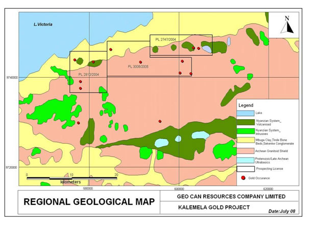
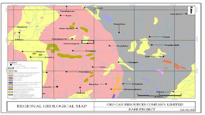
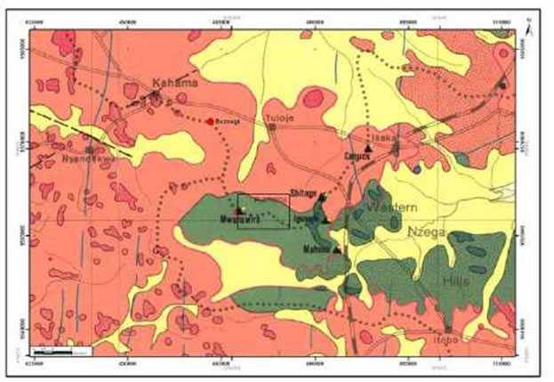
Map 4: Regional Geological Map for the Kalemela Gold Project, July 2008
Kalemela Exploration Program
The Kalemela property consists of undeveloped raw land that is easily traversed and prospected. To our knowledge, the property has only had shallow artisanal mining pits.
To evaluate the property, we implemented an initial exploration program consisting of geochemical surveys such as rock chip, soil sampling, trenching and geological mapping. These activities have to traverse faults inferred from aeromagnetic and from ground magnetic geophysical surveys.
Work done on PL2747/2004 through our exploration services agreement with Geo Can to date includes: geological mapping at a scale of 1:10,000; 61 rock chip samples; 1,589 soil samples, the soil sampling grid was 200 meters x 50 meters; ten trenches 1 to 2 meters deep were dug for a combined length of 156 meters; 50 samples were
-13-
collected on rock chip and soil anomalies to define the width of mineralization within the target area; three pits were dug and a detailed ground magnetic survey has been completed that covered the entire license. This magnetic survey has defined the structural setting and rock types present underlying below the mbuga soils.
All of the samples have been tested to determine if mineralized material is located on the property. We take our soil, grab and rock chip samples to analytical chemists, geochemists and registered assayers located in the city of Mwanza. Based upon initially encouraging results, we continued our exploration operations on the contiguous licenses, PL3006 and PL2910.
Exploration work conducted on the three Kalemela Project Licenses PL2747, PL2910 and PL3006 involved the collection and gold analysis of a total of 3,692 soil samples, 2186 line kilometers of ground magnetic surveying and the collection of 61 rock samples. In PL2747, the soil samples identified a large gold anomaly that covers an area of about 2 kilometers x 6 kilometers and is partially shown in Map 5.
Map 5: Shows a geologic contact between granite and greenstone in PL2747 corresponding with soil sample gold assay results. This contact zone may be selected for an induced polarization geophysical survey to help define drill targets. The area of Map 5 lies in the northeast quarter of Map 6, which displays the interpreted results of the ground magnetic survey that was conducted.
Map 5: Kalemela Geological and Assay Map, September 2008
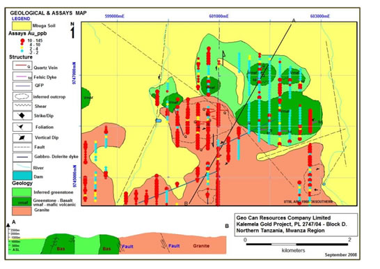
The ground magnetic survey identified geologic structures and rock contacts between granites and greenstones that could control gold mineralization; the results of 293 individual lines and 2,186 line kilometers of ground magnetic surveying are shown in Map 6.
Map 6: Interpreted Ground Magnetic Survey Results Note the strong northwest, cross cutting fracture zone image features that may control mineral formation.
-14-
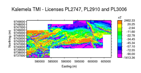
Table 3 : Kalemela Project Exploration Statistics
License Number |
Ground Magnetics
(Line Km) |
Soil Samples (Number) |
Rock Samples (Number) |
| PL2747 | 688 | 1589 | 33 |
| PL2910 | 648 | 1762 | 22 |
| PL3006 | 850 | 341 | 6 |
| Total: | 2,186 | 3,692 | 61 |
The cost of the initial exploration program for all three Kalemela Gold Project licenses was approximately $618,970; expenditures for PL2747 were $267,288; for PL2910 were $177,172 and for PL3006 were $174,510. The work program consisted of gridding, soil and rock sampling, geophysical ground magnetic surveying, trenching, geological mapping, soil and rock assays, report writing, accommodations and travel. The exploration work was contracted to be conducted by Geo Can, commencing in July, 2008 and completing in February, 2009 on all three Kalemela project licenses. Additional work such as an induced polarization geophysical survey and trenching may be planned to further define possible drill RAB (rapid air blast) and RC (reverse circulation) drill targets.
State Mining Project - PL4339/2006 and Igusule PL2702/2004 and PL5469/2008 (Relingquished)
On December 22, 2008, we completed an “Option to Purchase Prospecting Licenses Agreement” with Geo Can for PL4339/2006 and PL2702/2004. Under the terms of the agreement and the consideration paid, we acquired the exclusive and irrevocable option to acquire from the State Mining Corporation a 90% undivided interest in PL4339/2006 and PL2702/2004 through the Geo Can Option. In Oct 2008, PL2702/2004 was renewed for a second period of two years and was divided into two licenses PL2702/2004 and PL5469/2008. Dr. Roger A. Newell and Mr. Ahmed Magoma completed a field visit to PL2702 and PL5469 on January 19th 2009. Shallow iron stained artisanal mine pits are present and these pits reveal 0.5 meter to 1 meter thick northeast striking and steeply dipping quartz veins. Evidence of earlier RAB drilling was also observed. Plans and budgets for the mineral exploration program on these properties were prepared with an intent for the program to be conducted during the last two quarters of 2009, but, no work was commenced.
On August 10, 2009, the Company decided to release the above three licenses and transferred them back to State Mining Company on August 11 and September 15, 2009. The Company has abandoned its interests in this project and will not be involved any further exploration activities. No exploration activities were conducted on these licenses during this reporting period.
Hombolo Village PL4339/2006
-15-
Location and Access
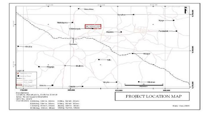
The Hombolo Prospect is under PL 4339/2006 issued to the State Mining Corporation (STAMICO) on 9th May, 2007 and is valid for 36 months from the date of grant. It was transferred to Geo Can on September 24, 2008. The total area is 92.22 km2 and lies within QDS 162/2 (Dodoma East) at Hombolo village. Access is generally easy as the properties are traversed by a number of roads that connect nearby villages (MAP 7).
Physiography
The environment for which Hombolo prospect may fall is that of “calcrete related environment in quaternary deposits”. The Hombolo prospect is in QDS 162/2 (Dodoma East). The Hombolo area is covered by mbuga and seasonal swamps. It forms an internal drainage basin. The prospect is being highly selected for uranium investigations. There has been no previous detailed investigations in the area except for the general regional mapping campaign by the Geological Survey of Tanzania.
Geology
Geological Environments for Uranium Mineralization in Tanzania
There are four know environments for uranium mineralization in Tanzania: -
- In sandstones, especially of the Karron Super Group and Bukoba Super Group
- In carbonatite complexes of Mesozoic to Recent age.
- In calcretes related secondary environment in quaternary deposits.
- In unconformities between Karagwe – Ankolean and Bukoba Super Group for vein-type uranium mineralization.
The environment for which Hombolo prospect may fall is that of “calcrete related environment in quaternary deposits”. The Hombolo area is covered by mbuga and seasonal swamps. It forms an internal drainage basin. On the basis of one of the geological environments for uranium mineralization in Tanzania -In calcretes related secondary environment in quaternary deposits, the Hombolo prospect is being highly selected for uranium investigations. There has been no previous detailed investigations in the area except for the general regional mapping campaign by the Geological Survey of Tanzania.
MAP 7: Location map of PL4339/2006
-16-
Map 8: Geology and Location Map PL4339/2006
Local (Deposit) Geology
-17-
The Hombolo area is covered by mbuga and seasonal swamps. It forms an internal drainage basin. On the basis of one of the geological environments for uranium mineralization in Tanzania - In calcretes related secondary environment in quaternary deposits, the Hombolo prospect is being highly selected for uranium investigations. The Hombolo lake is dischargeless drainage basin. The surface material consists of black, sandy, clay like material. Beneath the clays, there are clayey sediments which are calcerous and also gypsiferous. The sediments have are yet to be tested for uranium.
History
Uranium anomalies were selected from the airborne geophysical survey results for ground follow up in the 1980/81 field season. With the exception of the anomaly detected over the Ngualla Carbonatite (QDS 209), these anomalies originated from outcropping granitic/gneiss rocks and mbugas (seasonal swamps). Granitic/gneiss rocks were found to contain very low concentrations of syngenetic Uranium. Mbuga anomalies were found to be caused by secondary Uranium which has been precipitated from water drainage into these Mbugas during the wet season.
The areas that were investigated during the airborne geophysical survey comprised QDS 121, 122, 123, 124, 140, 141, 142, 143, 158, 159, 161, 162, 176, 177, 178, 179 and 209.
Aside from the countrywide Radiometric Airborne survey, there has been no previous detailed investigations on PL4339 except for the general regional mapping campaign by the Geological Survey of Tanzania.
Our Proposed Exploration Program
Plan for Hombolo PL4339
Detailed ground radiometric survey at 100m grid will be completed on the anomalous block indicated during country wide Airborne geophysics survey. Trenches and pitting will be done to validate the previous anomaly. The survey will be followed up by shallow RAB or Auger drilling.
Igusule PL2702/2004
Location and Access
The Igusule tenement, PL 2702/04, is situated within the Kahama District, Shinyanga region, about 100km SE of Bulyanhulu mine and approximately 20km SE of the Buzwagi deposit. It is located within the Nzega –Iramba greenstone belt, in the Lake Victoria Goldfields of northwestern Tanzania.
Physiography and Climate
The Igusule, PL2702/2004 is underlain by both lower Nyanzian basalts and Upper Nyanzian volcaniclastic sediments. Felsic dykes, granite and ultramafic rocks have intruded the Nyanzian lithologies in the area. Most of the area has outcropping lithologies (mainly greywacke to the east and basalt on the western boundary). Granitic sand has been mapped on the NE corner of the tenement. The area is located on the gravity high and is characterized by crustal scale structural intersections of WNW, NE, EW and NS- trending magnetic lineaments.
Map 9: Geology and Location Map of PL2702/2004
-18-
-19-
History
The Igusule, PL2702/2004 had exploration work completed by Barrick Exploration Africa Limited (BEAL) in the tenement that included; Airborne magnetic survey, Gravity survey, Geological mapping (1:20,000), soil geochemical sampling (1054) and RAB (1,905m) drilling programs.
Soil geochemical sampling program (1054 samples) has been conducted over the tenement in February and March 2006. The program started with 800m x 100m grid followed by an infill sampling at 400m x 100m spacing over the area with in-situ soils. All soil samples were analyzed for Au and multi-element -ME-ICP41. Wide-spaced RAB was used to investigate the Au-in-soil anomalies.
Three wide-spaced RAB fences (approx 100m between holes) were drilled at the tenement (PL 2702) area. A total of 1,905m of RAB drilling (23 holes) were completed in the tenement. The main lithological units encountered include, mafic volcanic (fine to medium grained), ultra-mafic intrusive and felsic dykes, which crosscuts all lithologies.
Our Proposed Exploration Program
Plan for Igusule PL2702 – By combining the Mag-Gravity superimposed image with RAB drilling results we see that there are 2 or 3 prospective targets. One just east of the Artisanal mining and the RAB drilling fence area with significant structural intersections that may be the extension of Artisanal mining and RAB drilling program area, The other target is south of the RAB drilling fence where there is another structural intersection .The third target is located east of the major fault and just in the contact between the Gravity high and low and containing several structural intersections.
Geita Project PL2806/2004 and PL5958/2009
On January 27, 2009, we executed a definitive Option Agreement (the “Option”) with Geo Can to earn a 50% interest in Geo Can’s Geita Gold Project, Prospecting License Number PL2806. Under the terms of the Option, we acquired a 50% interest in the “Property” totaling 43.77 sq km. The “Option” also provides for the Company to acquire, through “Remaining Interest Options,” up to a 75% interest in the gold project. The Geita Gold Project (License number: PL2806/2004) is located in Northern Tanzania within the Lake Victoria goldfields in the Geita District, Mwanza Region. This license is approximately 300 meters south of AngloGold-Ashanti’s world-class Nyankanga gold deposit, about 6 kilometers west of the town of Geita and about 78 kilometers west of Mwanza. The original prospecting license PL2806 has been divided and the project is now comprised of two licenses: PL2806/2004 – 21.59 sq.km. and PL5958/2009 – 20.85 sq.km. which totals about 42.44 sq.km.
During 2008 Geo Can completed detailed ground magnetic surveys, and both reconnaissance and detailed electrical prospecting (induced polarization, I.P.) surveys. Following this work, we commenced drilling on the Geita Project in January, 2009 and completed 37 reverse circulation drill holes for a total of 3,508 meters (11,506 feet). The drilling identified sub-economic gold values; the best mineralized intersection was 2 meters of 3.03 grams per metric ton from 50 meters to 52 meters in drill hole GR-15. The geophysical and geological information continues to be reviewed to determine if additional exploration targets exist that justify additional work. No additional work was conducted on the project during this reporting period.
Description and Location
The Geita property (License number: PL2806/204) is situated in the famous Lake Victoria goldfields in Geita district, Mwanza region, northern Tanzania. It is located between Latitude 2o 54’S and 2o 92’S and Longitude 32° 06’E and 32° 22’E that encompasses an area of 43.77 square kilometers. This area lies approximately 300 meters south of AngloGold-Ashanti’s world-class Nyankanga gold deposit, 6 Km west of the town of Geita and 78 Km west of the city Mwanza. Mwanza, on the southern shore of Lake Victoria is an important port and the second largest city in Tanzania.
-20-
Accesiblility, Infrastructure, Physiography and Climate
Geita (Map 10) can be reached by air via Mwanza International airport, located in Mwanza town and then 78 Km drive to Geita town via Geita-Biharamulo tarmac road. The property can as well be reached from Kahama district, Shinyanga through Kakola–Geita road. The Geita town has several mobile telephone networks (Vodacom, Celtel, Zantel, Tigo and TTCL) and internet communication is available in local internet cafes.
Topographically on the north side, the property consists of prominent hills and relative low hills on the southern side (Map 11). Nyamalembo on the northeast side of the property is the highest reaching elevation of 1474 metres above sea level (Map 11 and 12). Most of the hills consist of granitic rocks with the exception of Samena Hill (on the northwest side), which is composed of greenstone rocks. The hill slopes are covered by Fe rich fertile red or black soil that grades to black cotton soil on the far south of the hills. The property area is drained at its midway by the Mtakuja stream, which flows northwesterly into swamps near Nungwe Bay at the Lake Victoria. The climate is tropically humid with two major seasons, a wet season that starts from November to May and a dry season the remainder of the year. The wet season’s maximum rainfall is between March and April. To date, weather has not affected exploration progress.
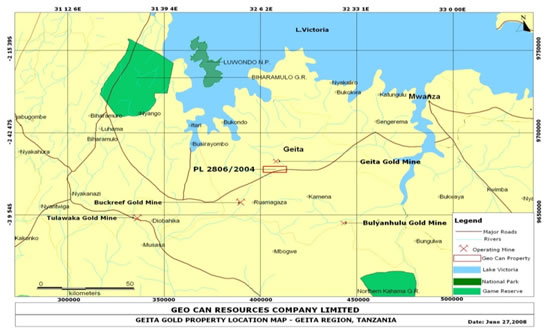
Map 10: Geita Property location, major roads, gold mines and gold occurrences
-21-
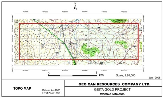
Map 11: Topographical map of the Geita property
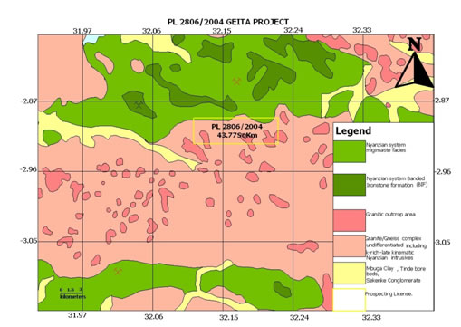
Map 12: Geology and Location Map of PL2806/2004
History
The Geita area has been the most productive gold area in Tanzania with nearly a continuous history of mining activity from 1932 to the present. To the northwest at Samena Hill, prospecting and exploration dates back to the 1930s when the search for gold lead to the discovery of a massive sulphide deposit.
-22-
In 1961, the Geological Survey of Tanganyika carried out geophysical surveys and drilling programs. A number of boreholes contained some anomalous base metals but only small amounts of gold. Before closing in 1966, Geita Gold Mines Ltd. constituted the largest gold operation in East Africa. It produced 5.5 million tons of ore at an average grade of 5.3g/t gold from five deposits including Geita, North-East Extension, Lone Cone, Prospect 30 and Ridge 8.
In 1994, Cluff Resources (UK based company) acquired ground east and west of Geita including the Old Geita mines and surrounding prospects. Cluff conducted exploration work at Lone Cone, Samena, Nyamonge and Prospect 30. Significant discoveries were made in 1996 when Cluff was acquired by Ashanti Gold. Ashanti continued exploration work and discovered additional high grade mineralized zones at Nyankanga west of Lone Cone. Later in 1997, Samax Resources acquired properties to the north and northeast of Geita Hill (Old Geita mine) at the location called Kukuluma and Matandani. Presently AngloGold-Ashanti owns the Geita Gold mine.
The Geita Gold Mine is subdivided by northwest trending deformation corridors separated into three distinct sub-terrains, which have been named Nyamulilima in the west, Nyankanga-Geita in the central and Kukuluma to the northeast. The Nyankanga block is situated on the southern limb of a west plunging synform with a west-northwest trending axial plane. The mineralized zone extends more than a kilometer to the northeast, and to a depth of at least 150 meters.
The Kukuluma trend comprises five deposits within a five kilometer long east-southeast mineralized trend that cuts obliquely across northwest trending horseshoe ridges. The deposits are located six kilometers northeast of Nyankanga Block. The mineralization is open at depth. Grades and widths indicate an underground mine might be possible at a future time.
At Samena Hill prospecting and exploration activities are recorded back to the 1930’s. Several companies and individuals combed the area looking for gold without success. The discovery of the massive sulphides was rather accidental and the discoverers thought that in the end, the sulphides would lead them to a gold deposit.
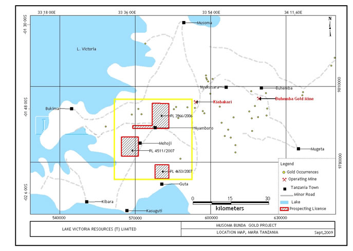
Musoma Bunda Gold Project
The Musoma Bunda Gold Project is comprised of three Prospecting Licenses (PLs) (see Table 2 and Figure 13) that are located on the eastern side of Lake Victoria. All three licenses lie within the Musoma-Mara Greenstone belt.
Location and Access
The three prospecting licenses (Table 1) lie to the west of the main Mwanza-Musoma tar road in the Musoma District (see Figure 1). The licenses are located some 30 to 60km south of Musoma, the major town in the district. Access to the individual licenses is via all weather dirt roads that connect to the various villages within the license areas. The three licenses are commonly referred to by the following names:
- Kinyambwiga (PL 4653/2007)
- Murangi (PL 4511/2007)
- Suguti (PL3966/2006)
Physiography, Climate, Vegetation and Water
The area is typically flat lying and is covered by grass and scattered woodland. Black cotton soils (mbuga) cover the entire area. The Mohoji and the Serengeti Plains lie to the south and south east of the area respectively. Perennial streams bisect the mbuga landscape and drain into Lake Victoria. The climate is tropically humid with an alternative wet (March to April) and dry season (from October to December).
-23-
History
Regional exploration has been carried out in the Musoma District from the 1920s. Geosurvey International undertook an aeromagnetic survey across the region during 1976-77. Barth compiled a geological map of the Lake Victoria Goldfields on a 1:1,000,000 scale in 1990. Exploration and exploitation of gold in the Musoma-Mara Greenstone belt commenced in the 1920’s. Mining occurred during the colonial times at Buhemba and Kiabakari, located east of the Musoma Bunda license area. Various international companies have worked on parts of the licenses since the mid-1990s and have largely concentrated around artisanal sites. Known artisanal workings occur on both the Kinyambwiga and Suguti projects.
All artisanal sites are licensed as Primary Mining Licenses (PMLs) to Tanzanian Nationals. All 24 PMLs on the Kinyambwiga prospecting license have been purchased outright by Geo Can Resources Company Limited (Geo Can) and are titled in the name of a common director of Geo Can and Lake Victoria Mining Company, Inc..
Regional Geology
The area is largely underlain by the Archaean Nyanzian Supergroup suite of granitic rocks (the Musoma Series). These have been uncomformably overlain by metavolcanic rocks of the Kavirondian System. Most of the documented gold occurrences in the Musoma-Mara region lie within the Nyanzian formation. The greenstone belt extends for over 180km from the shores of Lake Victoria in the west to the Serengeti National Park in the east.
Shear-hosted, gold bearing quartz veins, often striking NNE-SSW are typically present within the greenstone rocks. A crosscutting northwest – southeast structural fabric is present.
Kinyambwiga
On April 2, 2009 we completed an “Option to Purchase Prospecting Licenses Agreement” with Geo Can for PL4653/2007. Under the terms of the agreement and the consideration paid, we will acquire the exclusive and irrevocable option to acquire from Geo Can an 80% undivided interest in PL4653/2007. The Kinyambwiga Gold Project is about 208 kilometers northeast of the city of Mwanza in northern Tanzania, in the Precambian Musoma-Mara greenstone belt of northern Tanzania, East Africa (Figure 13 ). The project is within the gold producing area near Lake Victoria, and about 25 kilometers southwest of the past producing Kiabakari mine (0.8M -oz Au).
Current assay results, including trench assays from 2008, appear to have defined about a 1,000 meter long mineralized zone with an approximate vein grade of 3.96 grams per metric ton; additional work is required to confirm these results. A total of more than 190 samples were collected during the 2009 trenching program; eighty-five quartz vein samples averaged 3.96 grams per metric ton gold.
The property covers an area of 30.89 square kilometers in quadrangle QDS23/1.
Previous exploration work completed included: geological and regolith mapping, ground magnetics at 200m grid, geochemical soil sampling at 200X50 grid, trenching, pitting and 6000 meters of Rotary Air Blast (RAB) and 1300 meters of Reverse Circulation (RC) drilling. A detailed ground magnetic survey at 50m grid spacing was completed on a portion of the prospecting license, and on June 4th, 2009 we began to excavate exploration trenches to further expose previously identified quartz veins. Over 50 trenches were excavated and rock samples from the trenches were submitted to an assay laboratory. Detailed ground magnetic surveying suggested that the previously identified quartz veins have a strike length of at least one kilometer. A detailed trenching program further defined the quartz veins, and 134 samples collected from 22 trenches averaged 2.28 grams per
-24-
metric ton. An additional 24 bulk samples were selected for leach assaying these samples returned and average of 3.48 grams per metric ton. Routine fire assays for these same 24 bulk samples averaged 3.56 grams per metric ton. Previous excavations and shallow reconnaissance drilling suggests that multiple veins are present and may extend over a 2 kilometer distance.
Distance from the nearest town of Bunda to the project is approximately 18 kilometers. Access from Bunda is over dirt roads through Guta Village; four wheel drive vehicles are required during the rainy season. The nearest airport is in Musoma. However, the airport in Mwanza is preferred which has regularly scheduled flights, and is connected to Bunda with a major paved highway. The distance from Mwanza to Bunda is approximately 190 kilometers.
Map 13: Musoma-Bunda Gold Project Location Map includes Kinyambwiga Project PL4653
The geology at Kinyambwiga consists of granites, northwest trending mafic dykes and northeast trending gold bearing quartz veins. The granites generally fall into two main categories: syn- and post-Nyanzian ages, the mafic dykes have moderate to strong magnetic properties, and the quartz veins follow consistent, through-going fault structures and have near vertical dips.
Shallow, small scale artisanal gold mining has intermittently exposed the veins over approximately 300 to 400 meters and to an estimated depth of about 15 meters. Exploration by Lake Victoria has focused on defining the locations and gold grades of multiple veins.
-25-
Kinyambwiga has two main areas of exploration interest: a northern zone with “alluvial” gold deposits and a southern zone of significant hard rock artisanal mining activity. From June 1, 2009 to date rock sampling, geologic mapping, a detailed ground magnetic survey, and a major trenching and sampling program has extended and projected the known vein system to the northeast for at least 1,000 meters. This detailed exploration program was designed to refine and extend results from the 2008 RC and RAB drilling program.
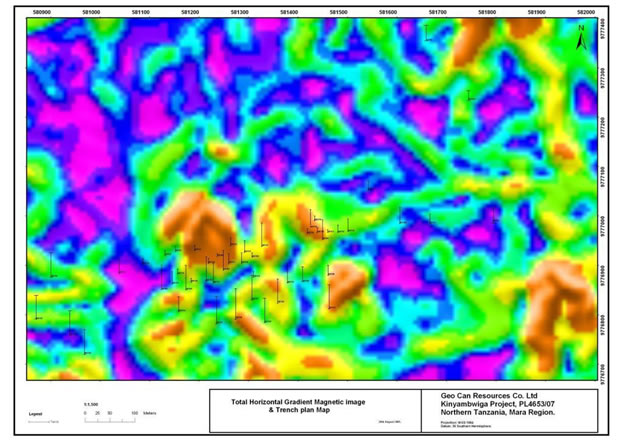
The 2009, detailed magnetic survey consists of 62 north-south lines of 2.3 kilometers long and spaced 50 meters apart; 143 line kilometers were surveyed using Company owned, state-of-the-art GPS equipped magnetometers. Interpretation of the detailed ground magnetic survey highlights the structural shift from east-northeast to a more northeast direction. From the artisanal workings, the vein-magnetic pattern extends both to the northeast and to the southwest, which suggests the quartz veins may have a length greater than one kilometer (see Map 9, magnetic image with superimposed trench locations).
Also NW trending fault is predominant and mostly associated with dolerite dykes. During the 2009 trenching program, 54 trenches excavated and detailed samples were collected from quartz veins exposed in 37 of the trenches. The trenching and sampling program covered a strike length of about one kilometer. Gold assay results including those from trenching in 2008 appear to have defined about a 1,000 meter long mineralized zone with approximate vein grades of 3.96 grams per metric ton (Table 4); much more work is required to confirm these results and to determine whether Kinyambwiga will contain a commercial ore body. Kinyambwiga does not contain a mineralized ore body to date.
Map 14: Map of Detailed Total Horizontal Gradient Magnetic Image with Superimposed Trench Locations at Kinyambwiga Project
Trench Observations
The main observations obtained during the trenching program are:
-26-
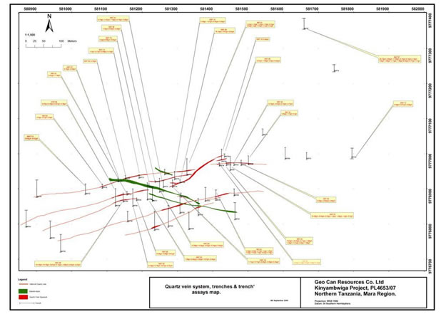
The western part of the vein system has identified three (3) east-west striking parallel veins that are 20 to 50 meters apart; there is a northern vein, a central vein and a southern vein. The central vein curves and connects to the northern vein or main zone of artisanal mining and the intersection of these veins is an important exploration target.
A strike length of about 680 meters is present from trench KNT47 (580952E, 9776490N) in the west to trench KNT36 (581582E, 9776668N) in the east. The veins are mineralized with disseminated gold, pyrite, minor clay, sericite and hematite. Trench KNT36 has 0.8 meters of 3.465 grams per ton.
The southern vein is 100 meters south of the main vein and trench KNT40 exposed 2 meters of 2.74 grams of gold per ton. Other trenches KNT43, KNT48, KNT49, KNT51 and KNT52 also intersected the southern and provided significant gold assays (Map 15).
Granite is the main host rock, with associated cross-cutting mafic dikes. The main alteration minerals are silica, hematite and sericite. Disseminated pyrite is the main sulfide mineral; oxidation is very shallow, only 1 to 2 meters, and free gold is often observed in the shallow artisanal mine workings.
Mineralization Style
The mineralized system at Kinyambwiga consists of two or more steeply dipping, east-northeast striking quartz veins within deformed granites and with cross-cutting mafic dykes. The veins vary in thickness from 0.3 meters to 4m thick and have a tendency to narrow and widen. A structure at trench KNT07 defines a 7 meter wide quartz vein with 5.33 grams/ton that includes 1.5 meters of 15.61 grams/ton (Map 15).
Map 15: Kinyambwiga Gold Assays from Intersected Quartz Veins, Trenches and Trench Assays
-27-
Trenching and assaying results have identified possible extensions to the known quartz vein system and the gold assays confirm that the veins contain important amounts of gold. Additional work is planned to further advance the project.
Trench Assay Results
Trench samples from the quartz vein channel samples as well as chip samples show the continuity and extent of the mineralized corridor.
Alteration associated with gold mineralization includes silicification, hematite, weak sericite and disseminated fine grained pyrite is the main sulfide associated with high grade gold. Visible gold is present in trench KNT30.
Table 4 : Trench Gold Assay Results
(* indicates
samples with gold values 1 gm/ metric ton or greater)
| Trench ID | Sample No. | Sample Type | Weight(Kg) | From | To | Interval(m) | Rock type | Au(Gold) | Ore Zone width(M) | Analysis Method |
| KNT01 | KNT01_126 | channel | 2 | 18.7 | 19 | 0.3 | GR | 0.66 | FAA505 | |
| KNT01 | KNT01_127 | channel | 2 | 19 | 19.5 | 0.5 | QV | 12.95* | BLEG | |
| KNT01 | KNT01_128 | channel | 2 | 19.5 | 20 | 0.5 | QV | 1.6* | BLEG | |
| KNT01 | KNT01_129 | channel | 2 | 20 | 20.5 | 0.5 | QV | 5.08* | 3.5m | BLEG |
| KNT01 | KNT01_130 | channel | 2 | 20.5 | 21 | 0.5 | QV | 0.92 | BLEG | |
| KNT01 | KNT01_131 | channel | 2 | 21 | 21.5 | 0.5 | QV | 2.72* | BLEG | |
| KNT01 | KNT01_132 | channel | 2 | 21.5 | 22 | 0.5 | QV | 1.3* | BLEG | |
| KNT01 | KNT01_133 | channel | 2 | 22 | 22.5 | 0.5 | QV | 1.48* | BLEG | |
| KNT01 | KNT01_134 | channel | 2 | 22.5 | 22.8 | 0.3 | GR | 0.7 | FAA505 | |
| KNT01 | KNT01_368 | box sample | 2 | 19 | 21 | 2 | QV | 1.3* | BLEG | |
| KNT01 | KNT01_369 | box sample | 2 | 21 | 23 | 2 | QV | 0.37 | BLEG | |
| KNT02 | KNT02_135 | Channel | 2 | 27.1 | 27.4 | 0.3 | GR | 0.08 | FAA505 | |
| KNT02 | KNT02_136 | Channel | 2 | 27.4 | 27.7 | 0.3 | GR | 0.26 | FAA505 | |
| KNT02 | KNT02_137 | Channel | 2 | 27.7 | 28.2 | 0.5 | QV | 12.58* | BLEG | |
| KNT02 | KNT02_138 | Channel | 2 | 28.2 | 28.7 | 0.5 | QV | 4.38* | 1.3m | BLEG |
| KNT02 | KNT02_139 | Channel | 2 | 28.7 | 29 | 0.3 | QV | 2.03* | BLEG | |
| KNT02 | KNT02_141 | Channel | 2 | 29 | 29.3 | 0.3 | GR | 0.74 | FAA505 | |
| KNT02 | KNT02_375 | box sample | 2 | 27.7 | 28.7 | 1 | QV | 5.63* | BLEG | |
| KNT03 | KNT03_145 | Channel | 2 | 28.3 | 28.6 | 0.3 | GR | 0.11 | FAA505 | |
| KNT03 | KNT03_146 | Channel | 2 | 28.6 | 29.1 | 0.5 | QV | 8.68* | 1m | BLEG |
| KNT03 | KNT03_147 | Channel | 2 | 29.1 | 29.6 | 0.5 | QV | 0.57 | BLEG | |
| KNT03 | KNT03_148 | Channel | 2 | 29.6 | 29.9 | 0.3 | GR/QV | 0.92 | FAA505 | |
| KNT03 | KNT03_149 | Channel | 2 | 29.9 | 30.2 | 0.3 | GR | 0.46 | FAA505 | |
| KNT03 | KNT03_150 | Channel | 2 | 30.2 | 30.5 | 0.3 | GR | 0.63 | FAA505 | |
| KNT03 | KNT03_151 | Channel | 2 | 30.5 | 30.8 | 0.3 | GR | 1.08* | FAA505 | |
| KNT03 | KNT03_383 | box sample | 2 | 28.6 | 29.6 | 1 | QV | 1.4* | BLEG | |
| KNT04 | KNT04_157 | Channel | 2 | 19.2 | 19.5 | 0.3 | MAF | 0.57 | FAA505 | |
| KNT04 | KNT04_166 | Channel | 2 | 21.6 | 21.9 | 0.3 | MAF | 0.1 | FAA505 | |
| KNT04 | KNT04_169 | Channel | 2 | 22.5 | 22.8 | 0.3 | GR | 0.67 | FAA505 | |
| KNT04 | KNT04_170 | Channel | 2 | 39 | 39.3 | 0.3 | GR | 0.11 | FAA505 | |
| KNT04 | KNT04_171 | Channel | 2 | 39.3 | 39.6 | 0.3 | GR | 0.18 | FAA505 | |
| KNT04 | KNT04_172 | Channel | 2 | 39.6 | 39.9 | 0.3 | GR | 0.25 | FAA505 | |
| KNT04 | KNT04_173 | Channel | 2 | 39.9 | 40.2 | 0.3 | GR | 0.75 | FAA505 | |
| KNT04 | KNT04_174 | Channel | 2 | 40.2 | 40.5 | 0.3 | GR | 2.19* | FAA505 | |
| KNT04 | KNT04_175 | Channel | 40.5 | 40.8 | 0.3 | GR | 0.21 | FAA505 | ||
| KNT05 | KNT05_184 | Channel | 2 | 12.1 | 12.4 | 0.3 | GR | 0.27 | FAA505 | |
| KNT05 | KNT05_185 | Channel | 2 | 12.4 | 12.7 | 0.3 | GR | 0.44 | FAA505 | |
| KNT05 | KNT05_186 | Channel | 2 | 12.7 | 13 | 0.3 | GR | 0.17 | FAA505 | |
| KNT05 | KNT05_188 | Channel | 2 | 25.1 | 25.5 | 0.4 | QV | 0.31 | 0.4m | BLEG |
| KNT05 | KNT05_189 | Channel | 2 | 25.5 | 25.8 | 0.3 | GR | 0.18 | FAA505 | |
| KNT07 | KNT07_394 | channel | 2 | 16 | 16.5 | 0.5 | GR | 0.08 | FAA505 | |
| KNT07 | KNT07_395 | channel | 2 | 16.5 | 17 | 0.5 | GR | 4.15* | FAA505 |
-28-
| KNT07 | KNT07_396 | channel | 2 | 17 | 17.5 | 0.5 | QV | 0.6 | BLEG | |
| KNT07 | KNT07_397 | channel | 2 | 17.5 | 18 | 0.5 | QV | 9.52* | BLEG | |
| KNT07 | KNT07_398 | channel | 2 | 18 | 18.5 | 0.5 | QV | 1.99* | 3m | BLEG |
| KNT07 | KNT07_399 | channel | 2 | 18.5 | 19 | 0.5 | QV | 3.16* | BLEG | |
| KNT07 | KNT07_402 | channel | 2 | 19 | 19.5 | 0.5 | QV | 5.9* | BLEG | |
| KNT07 | KNT07_404 | channel | 2 | 19.5 | 20 | 0.5 | QV | 1.69* | BLEG | |
| KNT07 | KNT07_405 | channel | 2 | 20 | 20.5 | 0.5 | QV | 0.08 | BLEG | |
| KNT07 | KNT07_406 | channel | 2 | 20.5 | 21 | 0.5 | QV | 0.68 | BLEG | |
| KNT07 | KNT07_407 | channel | 2 | 21 | 21.5 | 0.5 | GR | 0.11 | FAA505 | |
| KNT07 | KNT07_408 | channel | 2 | 21.5 | 22 | 0.5 | GR | 0.17 | FAA505 | |
| KNT07 | KNT07_409 | channel | 2 | 22 | 22.5 | 0.5 | QV | 26.72* | BLEG | |
| KNT07 | KNT07_410 | channel | 2 | 22.5 | 23 | 0.5 | QV | 8.16* | BLEG | |
| KNT07 | KNT07_411 | channel | 2 | 23 | 23.5 | 0.5 | QV | 11.94* | 2.5m | BLEG |
| KNT07 | KNT07_412 | channel | 2 | 23.5 | 24 | 0.5 | QV | 0.16 | BLEG | |
| KNT07 | KNT07_413 | channel | 2 | 24 | 24.5 | 0.5 | QV | 1.13* | BLEG | |
| KNT07 | KNT07_414 | channel | 2 | 24.5 | 25 | 0.5 | GR | 0.32 | FAA505 | |
| KNT08 | KNT08_190 | Channel | 2 | 1.2 | 1.5 | 0.3 | GR | 0.15 | FAA505 | |
| KNT08 | KNT08_191 | Channel | 2 | 1.5 | 1.8 | 0.3 | GR | 0.85 | FAA505 | |
| KNT08 | KNT08_192 | Channel | 2 | 1.8 | 2.1 | 0.3 | GR | 0.2 | FAA505 | |
| KNT08 | KNT08_193 | Channel | 2 | 2.1 | 2.6 | 0.5 | QV | 1.74* | 0.5m | BLEG |
| KNT08 | KNT08_194 | Channel | 2 | 2.6 | 2.9 | 0.3 | GR | 0.39 | FAA505 | |
| KNT08 | KNT08_373 | box sample | 2 | 2.1 | 2.6 | 0.5 | QV | 2.25* | BLEG | |
| KNT09 | KNT09_197 | Channel | 2 | 2.7 | 3.2 | 0.5 | QV | 5.51* | BLEG | |
| KNT09 | KNT09_199 | Channel | 2 | 3.2 | 3.7 | 0.5 | QV | 5.25* | 1m | BLEG |
| KNT09 | KNT09_201 | Channel | 2 | 3.7 | 4 | 0.3 | GR | 0.16 | FAA505 | |
| KNT09 | KNT09_374 | box sample | 2 | 2.7 | 3.7 | 1 | QV | 5.79* | BLEG | |
| KNT15 | KNT15_225 | Channel | 2 | 2 | 2.3 | 0.3 | GR | 0.18 | FAA505 | |
| KNT15 | KNT15_227 | Channel | 2 | 2.6 | 3.1 | 0.5 | QV | 1.27* | BLEG | |
| KNT15 | KNT15_228 | Channel | 2 | 3.1 | 3.6 | 0.5 | QV | 0.26 | BLEG | |
| KNT15 | KNT15_229 | Channel | 2 | 3.6 | 4.1 | 0.5 | QV | 3.39* | 2m | BLEG |
| KNT15 | KNT15_230 | Channel | 2 | 4.1 | 4.6 | 0.5 | QV | 0.23 | BLEG | |
| KNT15 | KNT15_231 | Channel | 2 | 4.6 | 4.9 | 0.3 | GR | 0.25 | FAA505 | |
| KNT15 | KNT15_236 | Channel | 2 | 21.8 | 22.3 | 0.5 | QV | 0.24 | BLEG | |
| KNT15 | KNT15_376 | box sample | 2 | 2.6 | 3.1 | 0.5 | QV | 0.16 | BLEG | |
| KNT15 | KNT15_377 | box sample | 2 | 3.6 | 4.6 | 1 | QV | 0.63 | BLEG | |
| KNT15 | KNT15_378 | box sample | 2 | 21.8 | 22.3 | 0.5 | QV | 0.1 | BLEG | |
| KNT16 | KNT16_239 | channel | 2 | 3.5 | 4 | 0.5 | GR | 0.13 | FAA505 | |
| KNT16 | KNT16_242 | channel | 2 | 4 | 4.5 | 0.5 | GR | 0.54 | FAA505 | |
| KNT16 | KNT16_243 | channel | 2 | 4.5 | 5 | 0.5 | GR | 0.09 | FAA505 | |
| KNT16 | KNT16_244 | channel | 2 | 7 | 7.3 | 0.3 | GR | 1.1* | FAA505 | |
| KNT16 | KNT16_246 | channel | 2 | 7.8 | 8.3 | 0.5 | QV | 0.77 | 0.5m | BLEG |
| KNT18 | KNT18_248 | channel | 2 | 6.4 | 6.7 | 0.3 | GR | 0.09 | FAA505 | |
| KNT18 | KNT18_249 | channel | 2 | 6.7 | 7.2 | 0.5 | QV | 0.23 | BLEG | |
| KNT18 | KNT18_250 | channel | 2 | 7.2 | 7.7 | 0.5 | QV | 1.11* | 1.5m | BLEG |
| KNT18 | KNT18_251 | channel | 2 | 7.7 | 8.2 | 0.5 | QV | 0.34 | BLEG | |
| KNT18 | KNT18_252 | channel | 2 | 8.2 | 8.5 | 0.3 | GR | 0.43 | FAA505 | |
| KNT18 | KNT18_253 | channel | 2 | 8.5 | 9 | 0.5 | GR | 0.43 | FAA505 | |
| KNT18 | KNT18_255 | channel | 2 | 9.5 | 10 | 0.5 | GR | 0.26 | FAA505 | |
| KNT18 | KNT18_256 | channel | 2 | 11.5 | 12 | 0.5 | QV | 0.17 | BLEG | |
| KNT18 | KNT18-379 | box sample | 2 | 6.7 | 8.2 | 1.5 | QV | 0.93 | BLEG | |
| KNT19 | KNT19_432 | box sample | 2 | 22.8 | 23.8 | 1 | QV | 0.4 | FAA505 | |
| KNT21 | KNT21_276 | channel | 2 | 3 | 3.5 | 0.5 | QV | 1.74* | BLEG | |
| KNT21 | KNT21_278 | channel | 2 | 3.5 | 4 | 0.5 | QV | 3.51* | 1m | BLEG |
| KNT22 | KNT22_283 | channel | 2 | 2 | 2.5 | 0.5 | MAF | 3.72* | FAA505 | |
| KNT22 | KNT22_285 | channel | 2 | 2.8 | 3.3 | 0.5 | QV | 0.14 | 1m | BLEG |
| KNT22 | KNT22_286 | channel | 2 | 3.3 | 3.8 | 0.5 | QV | 0.15 | BLEG | |
| KNT23 | KNT23_326 | channel | 2 | 3 | 3.8 | 0.8 | QV | 3.73* | BLEG | |
| KNT23 | KNT23_327 | channel | 2 | 3.8 | 4.2 | 0.4 | QV | 2.41* | 1.7m | BLEG |
| KNT23 | KNT23_328 | channel | 2 | 4.2 | 4.7 | 0.5 | QV | 2.16* | BLEG | |
| KNT23 | KNT23_329 | channel | 2 | 4.7 | 5.3 | 0.6 | GR | 0.34 | FAA505 | |
| KNT23 | KNT23-370 | box sample | 2 | 3 | 4.7 | 1.7 | QV | 2.17* | BLEG |
-29-
| KNT26 | KNT26_288 | channel | 2 | 1.5 | 2 | 0.5 | MAF | 0.15 | FAA505 | |
| KNT26 | KNT26_289 | channel | 2 | 2 | 2.5 | 0.5 | MAF | 1.24* | FAA505 | |
| KNT26 | KNT26_290 | channel | 2 | 2.5 | 3 | 0.5 | GR | 0.53 | FAA505 | |
| KNT26 | KNT26_291 | channel | 2 | 3 | 3.5 | 0.5 | GR | 2.63* | FAA505 | |
| KNT26 | KNT26_292 | channel | 2 | 3.5 | 4 | 0.5 | GR | 0.43 | FAA505 | |
| KNT26 | KNT26_293 | channel | 2 | 4 | 4.5 | 0.5 | GR | 0.64 | FAA505 | |
| KNT26 | KNT26_294 | channel | 2 | 4.5 | 5 | 0.5 | GR | 0.31 | FAA505 | |
| KNT26 | KNT26_295 | channel | 2 | 5 | 5.5 | 0.5 | MAF | 0.81 | FAA505 | |
| KNT26 | KNT26_296 | channel | 2 | 5.5 | 6 | 0.5 | MAF | 0.29 | FAA505 | |
| KNT26 | KNT26_297 | channel | 2 | 6 | 6.5 | 0.5 | MAF | 0.15 | FAA505 | |
| KNT26 | KNT26_298 | channel | 2 | 6.5 | 7 | 0.5 | MAF | 0.33 | FAA505 | |
| KNT26 | KNT26_302 | channel | 2 | 7.5 | 8 | 0.5 | QV | 1.04* | BLEG | |
| KNT26 | KNT26_303 | channel | 2 | 8 | 8.5 | 0.5 | QV | 5.87* | BLEG | |
| KNT26 | KNT26_306 | channel | 2 | 9 | 9.5 | 0.5 | QV | 14.19* | 2m | BLEG |
| KNT26 | KNT26_307 | channel | 2 | 9.5 | 10 | 0.5 | QV | 3.72* | BLEG | |
| KNT26 | KNT26_309 | channel | 2 | 10.5 | 11 | 0.5 | GR | 1.9* | FAA505 | |
| KNT26 | KNT26_310 | channel | 2 | 11 | 11.5 | 0.5 | GR | 0.36 | FAA505 | |
| KNT26 | KNT26_311 | channel | 2 | 21 | 21.5 | 0.5 | GR | 2.06* | FAA505 | |
| KNT26 | KNT26_312 | channel | 2 | 21.5 | 22 | 0.5 | QV | 3.45* | BLEG | |
| KNT26 | KNT26_313 | channel | 2 | 22 | 22.5 | 0.5 | QV | 10.15* | BLEG | |
| KNT26 | KNT26_314 | channel | 2 | 22.5 | 23 | 0.5 | QV | 0.56 | BLEG | |
| KNT26 | KNT26_315 | channel | 2 | 23 | 23.5 | 0.5 | QV | 2.21* | 3m | BLEG |
| KNT26 | KNT26_316 | channel | 2 | 23.5 | 24 | 0.5 | QV | 0.43 | BLEG | |
| KNT26 | KNT26_318 | channel | 2 | 24 | 24.5 | 0.5 | QV | 0.45 | BLEG | |
| KNT26 | KNT26_323 | channel | 2 | 25.5 | 25.8 | 0.3 | GR | 0.18 | FAA505 | |
| KNT27 | KNT27_336 | channel | 2 | 6.3 | 6.7 | 0.4 | QV | 5.75* | 0.4m | BLEG |
| KNT27 | KNT27_337 | channel | 2 | 6.7 | 7 | 0.3 | MAF | 0.35 | FAA505 | |
| KNT27 | KNT27_391 | box sample | 2 | 6.3 | 6.7 | 0.4 | QV | 2.06* | BLEG | |
| KNT28 | KNT28_339 | channel | 2 | 5 | 5.5 | 0.5 | QV | 3.76* | 0.5m | BLEG |
| KNT28 | KNT28_343 | channel | 2 | 5.5 | 6 | 0.5 | GR | 2.27* | FAA505 | |
| KNT28 | KNT28_392 | box sample | 2 | 5 | 5.8 | 0.8 | QV | 4.76* | BLEG | |
| KNT29 | KNT29_345 | channel | 2 | 3.3 | 4 | 0.7 | QV | 0.5 | BLEG | |
| KNT29 | KNT29_346 | channel | 2 | 4 | 4.3 | 0.3 | GR | 1.59* | FAA505 | |
| KNT29 | KNT29_349 | channel | 2 | 9 | 9.5 | 0.5 | GR | 0.32 | FAA505 | |
| KNT29 | KNT29_371 | box sample | 2 | 3.3 | 4 | 0.7 | QV | 3.61* | BLEG | |
| KNT30 | KNT30_352 | channel | 2 | 3.7 | 4 | 0.3 | GR | 0.9 | FAA505 | |
| KNT30 | KNT30_353 | channel | 2 | 4 | 4.5 | 0.5 | QV | 1.21* | BLEG | |
| KNT30 | KNT30_354 | channel | 2 | 4.5 | 5 | 0.5 | QV | 2.71* | BLEG | |
| KNT30 | KNT30_355 | channel | 2 | 5 | 5.5 | 0.5 | QV | 1.42* | BLEG | |
| KNT30 | KNT30_356 | channel | 2 | 5.5 | 6 | 0.5 | QV | 10.63* | 2m | BLEG |
| KNT30 | KNT30_357 | channel | 2 | 6 | 6.5 | 0.5 | QV | 18.9* | FAA505 | |
| KNT30 | KNT30_358 | channel | 2 | 6.5 | 7 | 0.5 | GR | 1.59* | FAA505 | |
| KNT30 | KNT30_359 | channel | 2 | 7 | 7.3 | 0.3 | GR | 0.9 | FAA505 | |
| KNT30 | KNT30_372 | box sample | 2 | 4 | 6 | 2 | QV | 1.88* | BLEG | |
| KNT31 | KNT31_362 | channel | 2 | 17 | 17.3 | 0.3 | GR | 0.29 | FAA505 | |
| KNT31 | KNT31_363 | channel | 2 | 17.3 | 17.8 | 0.5 | QV | 1.27* | BLEG | |
| KNT31 | KNT31_364 | channel | 2 | 17.8 | 18.3 | 0.5 | QV | 2.14* | 1.5m | BLEG |
| KNT31 | KNT31_365 | channel | 2 | 18.3 | 18.8 | 0.5 | QV | 1.15* | BLEG | |
| KNT31 | KNT31_367 | channel | 2 | 18.8 | 19.1 | 0.3 | MAFIC | 0.15 | FAA505 | |
| KNT31 | KNT31_393 | box sample | 2 | 17.5 | 18.5 | 1 | QV | 0.55 | BLEG | |
| KNT36 | KNT36_495 | channel | 2 | 3 | 3.3 | 0.3 | GR | 1.37* | FAA505 | |
| KNT36 | KNT36_496 | channel | 2 | 3.3 | 3.8 | 0.5 | QV | 5.56* | 0.5m | BLEG |
| KNT36 | KNT36_503 | channel | 2 | 12 | 12.5 | 0.5 | GR | 0.1 | FAA505 | |
| KNT38 | KNT38_443 | channel | 2 | 8 | 8.5 | 0.5 | GR | 0.14 | FAA505 | |
| KNT38 | KNT38_444 | channel | 2 | 8.5 | 9 | 0.5 | GR | 0.96 | FAA505 | |
| KNT38 | KNT38_445 | channel | 2 | 9 | 9.7 | 0.7 | QV | 2.24* | BLEG | |
| KNT38 | KNT38_447 | channel | 2 | 9 | 9.7 | 0.7 | QV | 2.19* | 0.7m | BLEG |
| KNT38 | KNT38_448 | channel | 2 | 9.7 | 10 | 0.3 | GR | 0.59 | FAA505 | |
| KNT39 | KNT39_449 | channel | 2 | 3.6 | 4 | 0.4 | GR | 0.37 | FAA505 | |
| KNT39 | KNT39_450 | channel | 2 | 4 | 4.5 | 0.5 | QV | 0.23 | BLEG | |
| KNT39 | KNT39_451 | channel | 2 | 4.5 | 5 | 0.5 | QV | 0.73 | 2m | BLEG |
| KNT39 | KNT39_452 | channel | 2 | 5 | 5.5 | 0.5 | QV | 1.27* | BLEG | |
| KNT39 | KNT39_453 | channel | 2 | 5.5 | 6 | 0.5 | QV | 0.33 | BLEG | |
| KNT39 | KNT39_454 | channel | 2 | 6 | 6.7 | 0.7 | GR | 0.09 | FAA505 | |
| KNT39 | KNT39_455 | channel | 2 | 6.7 | 7.3 | 0.6 | GR | 1.27* | BLEG | |
| KNT39 | KNT39_457 | box sample | 2 | 6.7 | 7.3 | 0.6 | QV | 1.19* | 0.6m | BLEG |
| KNT39 | KNT39_458 | channel | 2 | 7.3 | 7.6 | 0.3 | GR | 0.12 | FAA505 |
-30-
| KNT39 | KNT39_459 | channel | 2 | 11.5 | 12 | 0.5 | GR | 0.18 | FAA505 | |
| KNT39 | KNT39_462 | channel | 2 | 12 | 12.7 | 0.7 | QV | 1.16* | 0.7m | BLEG |
| KNT39 | KNT39_464 | box sample | 2 | 12 | 12.7 | 0.7 | QV | 0.8 | BLEG | |
| KNT39 | KNT39_465 | channel | 2 | 12.7 | 13 | 0.3 | GR | 0.56 | FAA505 | |
| KNT39 | KNT39_466 | channel | 2 | 13 | 13.5 | 0.5 | GR | 0.1 | FAA505 | |
| KNT39 | KNT39_467 | channel | 2 | 13.5 | 14 | 0.5 | GR | 0.24 | FAA505 | |
| KNT39 | KNT39_468 | channel | 2 | 14 | 14.5 | 0.5 | GR | 0.09 | FAA505 | |
| KNT40 | KNT40_469 | channel | 2 | 2.5 | 3 | 0.5 | GR | 0.14 | FAA505 | |
| KNT40 | KNT40_470 | channel | 2 | 3 | 3.5 | 0.5 | GR | 0.11 | FAA505 | |
| KNT40 | KNT40_471 | channel | 2 | 3.5 | 4 | 0.5 | GR | 0.29 | FAA505 | |
| KNT40 | KNT40_472 | channel | 2 | 7 | 7.5 | 0.5 | GR | 1.5* | FA.A505 | |
| KNT40 | KNT40_473 | channel | 2 | 7.5 | 8 | 0.5 | GR | 1.47* | FAA505 | |
| KNT40 | KNT40_474 | channel | 2 | 8 | 8.5 | 0.5 | QV | 1.53* | 0.5m | BLEG |
| KNT40 | KNT40_475 | box sample | 2 | 8 | 8.5 | 0.5 | QV | 4.59* | BLEG | |
| KNT40 | KNT40_477 | channel | 2 | 9 | 9.5 | 0.5 | GR | 0.09 | FAA505 | |
| KNT40 | KNT40_479 | channel | 2 | 10 | 10.5 | 0.5 | GR | 0.54 | FAA505 | |
| KNT40 | KNT40_483 | channel | 2 | 11 | 11.5 | 0.5 | GR | 0.2 | FAA505 | |
| KNT40 | KNT40_486 | channel | 2 | 12.5 | 13 | 0.5 | QV | 1.01* | BLEG | |
| KNT40 | KNT40_487 | channel | 2 | 13 | 13.5 | 0.5 | GR | 1.2* | FAA505 | |
| KNT40 | KNT40_488 | channel | 2 | 13.5 | 14.2 | 0.7 | QV | 2.17* | BLEG | |
| KNT40 | KNT40_490 | box sample | 2 | 13.5 | 14.2 | 0.7 | QV | 6.58* | 0.7m | BLEG |
| KNT40 | KNT40_491 | channel | 2 | 14.2 | 14.5 | 0.3 | GR | 0.24 | FAA505 |
The trench assay results for 85 samples (shown above with an * have values of 1.0 gram per metric ton or greater) average 3.96 grams per metric ton. Standard and duplicate samples are not included when calculating the average grade. Note: Compiled results for trenches 41-54 were not available when completing the above report.
Exploration Strategy
The Exploration Strategy of the three prospecting Licenses is as follows:
Kinyambwiga (PL4653)
Past exploration has included a detailed ground magnetic survey over the artisanal sites and environs in the northeast part of the license. Rotary Air Blast (RAB) drilling (377 boreholes) totaling 7418 meters has been completed across ground magnetic targets in the northeastern part of the license. Reversed circulation (RC) drilling (21 boreholes) totaling 1543 meters focused on testing the two main artisanal sites on the license. This coupled with trenching has delineated a 400-meter long shear zone containing a number of narrow gold bearing quartz veins distributed over a surface width of 100 meters. Best borehole grades returned 20.9g/t Au over 2 meters and 5.14 g/t Au over 8 meters.
Exploration is to be focused at extending the strike length of the prospect by undertaking:
- Geological Mapping
- Geophysical gradient array and pole-dipole surveys
- Trenching
- RC drilling
Suguti (PL3966)
The Suguti license is covered by mbuga soils. A number of regional northeast southwest and crosscutting northwest-southeast structures, as noted from the Government regional aeromagnetic survey, pass through the license.
-31-
Exploration is to be focused at defining the underlying structure by means of a detailed ground magnetometer and gradient induced polarization (IP) surveys. Follow-up IP pole-dipole surveys will be planned over favorable targets.
Murangi (PL4511)
Similar to Suguti, the license is covered by mbuga soils. Ground magnetometer and gradient array IP surveys are planned to assist in the structural interpretation of this part of the greenstone belt.
It is recommended that a targeted electrical induced polarization (I.P.) geophysical survey be implemented and then to be followed by additional reverse circulation (RC) drilling and core drilling, during 2010, to confirm these assay results at depth below selected trenches, artisanal mine workings and identified geophysical targets.
Singida Gold Project
Company personnel first visited the Singida project area during March, 2009 and became aware of the high level of artisanal (small scale) gold mining that was being conducted along an estimated five (5) kilometer mineralized zone. Subsequently, on May 15, 2009, the Company signed a Mineral Financing Agreement with one director of the Company authorizing him, on behalf of the Company, to acquire Primary Mining Licenses (“PMLs”) in the Singida area. As of March 31, 2010, this director has entered into several different Mineral Properties Sales and Purchase agreements with multiple PML owners that hold title to the licenses along the mineralized zone at the Singida project area. Twenty-three (23) PML agreements were executed for an outright purchase of the PMLs and they have been completed. These twenty-three PMLs have been 100% acquired by this director in behalf of the Company. The Company also has option agreements to acquire an additional thirty-seven (37) PMLs within a targeted area at the Singida project. Under the terms of all the agreements, if we complete all sixty (60) of the various agreements, that combined form the Singida project area, then our total purchase consideration will be $7,029,404 by February , 2013.
At the option of the Company, we may relinquish any PML at any time during the agreement and transfer the title back to the original owner. Also, at the option of the Company, a 2% Net Smelter Production royalty or 2% of the Net Sale Value may be substituted in place of the final payment for each PML and paid on a pro rata basis determined by the total final number of PMLs involved in a special mining license.
On October 27, 2009, the Company signed and renewed a Mineral Properties Purchase Financing Agreement with one director of the Company which replaced the initial agreement with Kilimanjaro Mining on May 15, 2009. According to the renewed agreement, the Company shall provide all the finances required for acquiring and developing the PMLs in the Singida Project area and the Company will continue to have a 100% beneficial interest in all PMLs acquired by the director pursuant to the initial and renewed agreement.
On January 19, 2010, a director on behalf of the Company signed second addendums to Singida mineral properties sales and purchase agreements (“mineral agreement”) in 2009. The addendums revised and extended the secondary payments of the mineral agreements.
As of March 31, 2010, under the terms of the mineral properties sales and purchase agreements the Company has completed initial option payments in the amount of $904,148 and $61,482 is accrued as a short term liability.
-32-
On July 27 and 28th, 2010, a director on behalf of the Company signed third addendums to SingidaMineral Properties Sales and Purchase Agreements (“mineral agreement”) in 2009. The third addendums revised and extended the secondary payments of the mineral agreements.
As of July 28th, 2010, under the terms of the Mineral Properties Sales and Purchase Agreements and the Addendums entered into, the Company has completed option payments in the amount of $1,246,695.
Summary
The Singida Gold Project is located in central Tanzania about 600 kilometers south of Mwanza and approximately 90 kilometers south-southeast of the Regional government and commercial town center of Singida. The gold fields of interest were discovered in 2004 by a local farmer, and the location is now an active small scale artisanal mine site that appears ideal for larger scale mechanized mining.
Access from the town of Singida to the project is south over the main paved road to the village of Ikungi, and then easterly over an all-weather gravel road for a distance of about 70 kilometers to the village of Londoni. During the wet season, access within the project area requires 4WD vehicles.
The property covers an area of about 6 square kilometers in QDS (Quadrangle) number 123/3 for Londoni Village.
More than 200 mine shafts are estimated present along a shear zone vein system that is least five kilometers long. This mining activity lies along well defined, northwest-southeast trending silicified vein and shear zone structures that are in Precambrian Archean greenstone metavolcanic rocks. The shafts appear to average about 50 meters deep.
We began working in the area following an initial field visit by company personnel in March, 2009. To date work conducted on the project includes: geologic mapping, detailed ground magnetic and electrical induced polarization (I.P.) geophysical surveying, mine dump sampling, tailing sampling and sampling of thirty-six underground mine shafts and mine workings.
Detailed ground magnetic surveying consists of traverses totaling over 630 line kilometers, and over 50 line kilometers of IP surveying. Detailed geological mapping, magnetometer and IP surveying have defined a 5 kilometer long northwest-southeast trending mineralized sheared zone that contains a system of sub-parallel quartz veins known to carry important amounts of gold. The company has collected and assayed more than 8,000 rock samples for gold.
A total of 184 underground samples, 2,478 tailings samples, and 5,545 mine dump samples were sent to SGS or HUMAC laboratories in Mwanza for gold assaying.
Assays for 184 underground mine samples average 7.11 g/t; the highest grade is 140g/t. No Reserves or Resources are present at this time.
Property Description and Location
The Singida project is located in central Tanzania about 90 kilometers south-southeast of the town of Singida (Map 16).
-33-
Map 16: Singida Gold Project Location Map, Tanzania (PMLs held are shown in green)
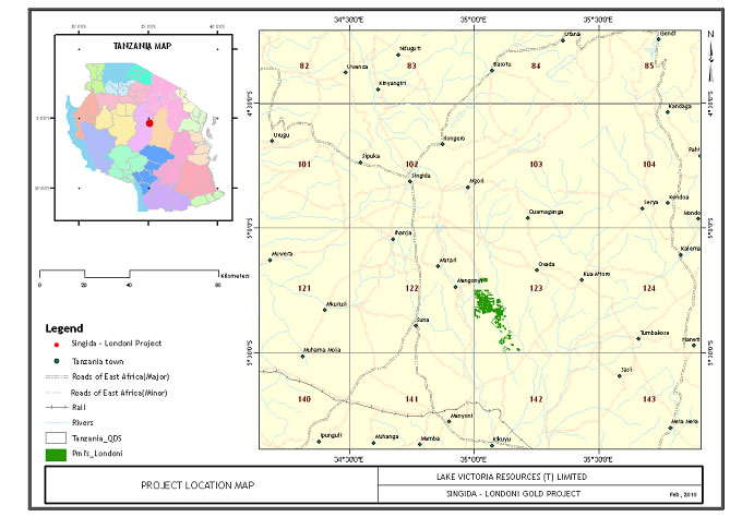
Accessibility, Climate, Local Resources, Infrastructure and Physiography
The Singida Gold Project is located in central Tanzania about 600 kilometers south of Mwanza and approximately 90 kilometers south-southeast of the Regional government and commercial town center of Singida.
The town of Singida has a population of approximately 75,000 people and a well-developed social and commercial infrastructure that includes transportation, telecommunications, educational institutes, hospitals, hotels, and recreational facilities.
The project area is hilly, covered with reddish iron rich soils, thorn bushes, grasses and small trees. Some small family farms are present and corn is the main crop. The climate in the area is tropically humid with two distinct seasons; a rainy season from November to May and a dry season from June to October. Day time temperatures in the dry season vary from 22-32ºC. The region can experience strong winds; climatic conditions are not expected to unduly restrict exploration programs.
History
The Singida area was included in a countrywide airborne magnetic and radiometric survey undertaken by Geosurvey International between 1976 and 1979. In 1990 after reviewing existing information on the area, H. Barth compiled a geological map of the Lake Victoria Goldfields at a scale of 1:500,000; unfortunately this study stopped at Latitude 50 South, just north of the Singida project area.
-34-
Geological Setting
The Singida project lies within the East African Archean craton. The Archaean craton in Tanzania consists largely of granites and related belts of volcanic and sedimentary greenstone rocks. The greenstone belts contain clastic debris of older granitic and gneissic basement rocks that locally abut against the older gneiss belts. The Archaean granites and greenstone belts are bordered on the west by a younger Proterozoic age Ubendian mobile belt. This Ubendian belt contains meta-sedimentary units not present in the Archaean, but that are considered to be metamorphosed relics of the Archaean sequences. The Ubendian rocks have undergone high-grade metamorphism and strong deformation. On the east, the Archaean block is bordered by the Neoproterozoic Mozambique mobile belt (Usagaran). The rocks of these belts include marbles and graphitic schists, gneisses and some high-grade granulites.
At the close of the Proterozoic, the entire region was effectively peneplained and buried by continental clastic sediments of the Bukoban System. Abundant mafic dikes cut this sequence and appear to have been nearly contemporaneous with sedimentation. Most of the Bukoban rocks have now been eroded, but a major outlier remains in northwestern Tanzania.
During the Mesozoic, clastic sediments of the Karoo Series were deposited in rift basins throughout eastern Tanzania. The oldest Karoo sequences are cut by a wide range of alkaline intrusives, including carbonatites, kimberlites and alkaline syenites. Tertiary sediments and volcanics overlie an erosion surface at the top of the Mesozoic. Subsequent formation of the Cenozoic rift valleys with their attendant sedimentation and alkalic volcanism has covered the Archaean and Proterozoic rocks in some areas, and at Singida iron rich soils have formed over the underlying greenstone rocks.
Regional Geology
The regional geology at Singida consists of Archean age porphyroblastic biotite granites and relatively minor amounts of greenstone rocks. The granitic terrain is similar to that found at Barrick’s large Buzwagi mine near the town of Kahama. At Singida, greenstone rocks hosting the gold mineralization are characterized by mafic volcanics, subordinate felsic volcanics and clastic sediments. These rocks have experienced multiple periods of deformation.
Property Geology
Associated with the mafic greenstone host rocks are sheared, fine to medium grained mafic dikes, a sheared mafic porphyry and gold bearing quartz veins. Ore minerals reported include native gold, pyrite, arsenopyrite, pyrrhotite and traces of chalcopyrite. Alteration and gangue minerals include hematite, silica, goethite, sericite, chlorite and limonite. Weathering and oxidation levels are believed to generally be between 15 and 20 meters deep. The project area is covered by reddish iron rich soils that are often 3 to 4 meters thick. Geologic mapping was conducted at a scale of 1:5,000 (Map 17).
-35-
Map 17: Geological Map of Primary Mining Licenses (PML’s) at the Singida Project
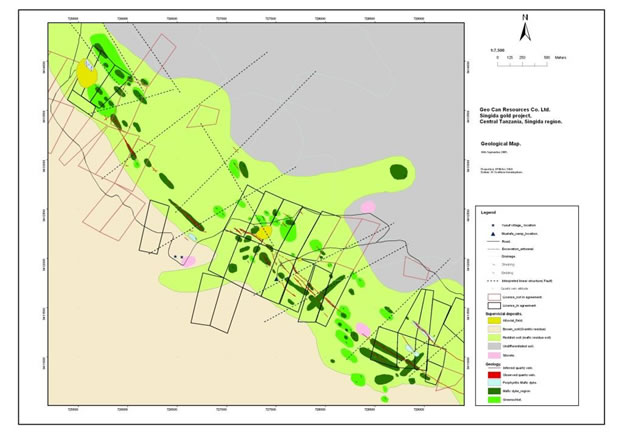
The mineralized quartz vein system trends northwest-southeast with a general strike of about 310 degrees; vein dips are near vertical at about 800 NE. Multiple sub-parallel quartz veins are present along the five kilometer strike length.
Deposit Types
Gold ores at Singida are associated with structurally controlled shear zone hosted quartz veins in mafic greenstone host rocks and with pyrite, arsenopyrite, pyrrhotite and traces of chalcopyrite. The combination of elevated gold values, five kilometers of quartz veining in northwest-southeast trending fracture zones, cross cutting dikes and deformed greenstone rocks makes Singida a very attractive gold exploration project.
Mineralization
Exploration at Singida has identified a five kilometer long strike length of quartz veins hosted in greenstone volcanic rocks. Artisanal mining is very active in the area,
Artisanal or small scale mining is from vertical mine shafts that have an average depth of about 50 meters, and based on safety conditions, Company geologists and technicians were able to enter and sample 36 of an estimated 200 mine shafts. A total of 184 samples were collected from the underground workings, and each sample weight was two kilograms. The samples were assayed at the SGS laboratory in Mwanza. In general, elevated gold values in the quartz veins are reported to correlate with stronger fracturing, more limonite and higher silicification. The higher gold values also tend to be associated with disseminated pyrite.
-36-
Map 18: Map of Mine Shaft Locations, Gold Assays and Vein Structures Exploration
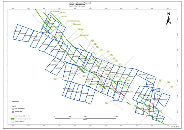
Exploration by the Company began in early June 2009 and continues until the time of this filing July, 2010. Exploration includes geologic mapping, mine shaft sampling and mapping, tailing sampling, mine dump sampling, ground magnetic and IP surveying.
Geological Mapping
Detailed geologic mapping by the Company is being conducted at a scale of 1:5,000 over the five kilometer long northwest trending mineralized zone. Multiple parallel to sub-parallel gold bearing quartz vein structures are present in volcanic greenstone rocks. These mineralized structures are well defined in the greenstone rock, and based on similar geologic settings, the veins could continue to a depth of at least 500 meters.
Sampling and Assaying
The Company’s exploration program collected 184 underground samples, 2,478 tailings samples, and 5,545 mine dump samples.
Underground Sampling
Many artisanal mine shafts lie along a 5 kilometer northwest trend and the shafts average about 50 meters deep. Samples were collected from the footwalls, the hanging walls and from within the quartz veins. The purpose of the underground sampling program was to determine the gold grades at depth.
-37-
Underground Sampling Procedure
Mine shafts were entered that were observed to be safe. Two samples were collected as channel samples across the quartz veins and a third chip sample was collected from the vein. The chip sample is termed a “box sample.” One sample was collected from the footwall and one sample from the hanging wall; a total of 5 samples were collected from each shaft. Each sample weighed 2 kilograms and the rock was crushed to about 2 centimeters in diameter. A one kilogram sample was shipped to the SGS laboratory in Mwanza and a second one kilogram sample is in storage for reference. Blank and standard samples were inserted at 20 sample intervals; each sample location was numbered and photographed.
Table 5: Assay Results from Sampling 36 Underground Small Scale Mining Shafts
Shaft Number |
Sample No |
Sampling depth (m) |
Au g/t |
(Quartz vein) |
Hanging wall |
Foot wall |
|
| SH001 | LNSH001 | 4 | 0.58 | 10cm | |||
| LNSH002 | 4 | 2.94 | F/W | ||||
| LNSH003 | 4 | 0.12 | H/W | ||||
| SH002 | LNSH004 | 4 | 0.04 | 30cm | |||
| LNSH005 | 4 | 0.08 | F/W | ||||
| LNSH006 | 4 | 0.05 | H/W | ||||
| SH003 | LNSH007 | 28 | 1.7 | 30cm | |||
| LNSH008 | 28 | 0.03 | F/W | ||||
| LNSH009 | 28 | 7.62 | H/W | ||||
| SH004 | LNSH010 | 41 | 5 | 50cm | |||
| LNSH011 | 41 | 10.1 | 50cm | ||||
| LNSH012 | 41 | 18.6 | 50cm | ||||
| LNSH013 | 41 | 3.07 | 50cm | ||||
| LNSH014 | 41 | 27.7 | F/W | ||||
| LNSH015 | 41 | 0.91 | H/W | ||||
| SH005 | LNSH016 | 18 | 3.21 | 50cm | |||
| LNSH017 | 18 | 5.86 | 50cm | ||||
| LNSH018 | 18 | 3.55 | 50cm | ||||
| LNSH019 | 18 | 1.41 | F/W | ||||
| LNSH021 | 18 | 21 | H/W | ||||
| SH006 | LNSH022 | 40.7 | 1.91 | 25cm | |||
| LNSH023 | 40.7 | 1.76 | 25cm | ||||
| LNSH024 | 40.7 | 0.38 | F/W | ||||
| LNSH025 | 40.7 | 2.6 | H/W | ||||
| SH007 | LNSH026 | 44 | 2.48 | 30cm | |||
| LNSH027 | 44 | 2.94 | Duplicate of LNSH027 | ||||
| LNSH028 | 44 | 0.52 | F/W | ||||
| LNSH029 | 44 | 15.9 | H/W | ||||
| SH008 | LNSH030 | 30 | 9.68 | 25cm | |||
| LNSH031 | 30 | 8.71 | 25cm | ||||
| LNSH032 | 30 | 9.54 | 25cm | ||||
| LNSH033 | 30 | 12.4 | 25cm | ||||
| LNSH034 | 30 | 1.61 | F/W | ||||
| LNSH035 | 30 | 2.69 | H/W | ||||
| SH009 | LNSH036 | 33 | 3.29 | 30cm | |||
| LNSH037 | 33 | 2.84 | Duplicate of LNSH036 | ||||
| LNSH038 | 33 | 3.16 | F/W | ||||
| LNSH039 | 33 | 0.16 | H/W | ||||
| SH010 | LNSH041 | 3 | 1.68 | 30cm | |||
| LNSH042 | 3 | 1.38 | Duplicate of LNSH041 | ||||
| LNSH043 | 3 | 0.47 | F/W | ||||
| LNSH044 | 3 | 1.3 | H/W | ||||
| SH011 | LNSH045 | 8 | 0.41 | 30cm | |||
| LNSH046 | 8 | 0.21 | Duplicate of LNSH045 | ||||
| LNSH047 | 8 | 0.47 | F/W | ||||
| LNSH048 | 8 | 0.05 | H/W | ||||
| SH012 | LNSH049 | 3 | 3.37 | 20cm | |||
| LNSH050 | 3 | 1.36 | Duplicate of LNSH049 | ||||
| LNSH051 | 3 | 0.03 | F/W | ||||
| LNSH052 | 3 | 0.02 | H/W |
-38-
| SH013 | LNSH053 | 3 | 3.9 | 20cm | |||
| LNSH054 | 3 | 1.16 | Duplicate of LNSH053 | ||||
| LNSH055 | 3 | 0.08 | F/W | ||||
| LNSH056 | 3 | 1.04 | H/W | ||||
| SH014 | LNSH057 | 10 | 1.65 | 30cm | |||
| LNSH058 | 10 | 0.93 | 30cm | ||||
| LNSH059 | 10 | 0.38 | Box sample | ||||
| LNSH061 | 10 | 1.65 | F/W(10cm) | ||||
| LNSH062 | 10 | 0.11 | H/W (10cm) | ||||
| SH015 | LNSH063 | 18 | 140 | 30cm | |||
| LNSH064 | 18 | 21.8 | 30cm | ||||
| LNSH065 | 18 | 82.8 | Box sample | ||||
| LNSH066 | 18 | 0.15 | F/W(20cm) | ||||
| LNSH067 | 18 | 0.5 | H/W(10cm) | ||||
| SH016 | LNSH068 | 2 | 4.11 | 20cm | |||
| LNSH069 | 2 | 1.67 | Duplicate of LNSH068 | ||||
| LNSH070 | 2 | 3.41 | Box sample | ||||
| LNSH071 | 2 | 0.33 | F/W(25cm) | ||||
| LNSH072 | 2 | 0.22 | H/W(15cm) | ||||
| SH017 | LNSH073 | 5 | 71 | 20cm | |||
| LNSH074 | 5 | 59.6 | Duplicate of LNSH073 | ||||
| LNSH075 | 5 | 37.8 | Box sample | ||||
| LNSH076 | 5 | 4.38 | F/W(10cm) | ||||
| LNSH077 | 5 | 0.57 | HW(10cm) | ||||
| SH018 | LNSH078 | 11 | 4.31 | 30cm | |||
| LNSH079 | 11 | 89.5 | Duplicate of LNSH079 | ||||
| LNSH081 | 11 | 27.6 | Box sample | ||||
| LNSH082 | 11 | 0.55 | F/W(10cm) | ||||
| LNSH083 | 11 | 3.1 | H/W(5cm) | ||||
| LNSH084 | 24 | 1.35 | 50cm | ||||
| LNSH085 | 24 | 18.6 | 50cm | ||||
| LNSH086 | 24 | 32.5 | Box sample | ||||
| LNSH087 | 24 | 1.61 | F/W(10cm) | ||||
| LNSH088 | 24 | 3.69 | H/W (10cm) | ||||
| SH019 | LNSH089 | 31 | 1.77 | 25cm | |||
| LNSH090 | 31 | 48.4 | 25cm | ||||
| LNSH091 | 31 | 11.9 | Box sample | ||||
| LNSH092 | 31 | 0.23 | F/W(10cm) | ||||
| LNSH093 | 31 | 11.8 | H/W (10cm) | ||||
| SH020 | LNSH094 | 3 | 0.16 | 20cm | |||
| LNSH095 | 3 | 0.18 | Duplicate of LNSH094 | ||||
| LNSH096 | 3 | 0.16 | Box sample | ||||
| LNSH097 | 3 | 0.27 | F/W (20cm) | ||||
| LNSH098 | 3 | 1.83 | H/W (10cm) | ||||
| SH021 | LNSH099 | 21 | 9.85 | 25cm | |||
| LNSH101 | 21 | 5.89 | 25cm | ||||
| LNSH102 | 21 | 7.49 | Box sample | ||||
| LNSH103 | 21 | 1.41 | F/W | ||||
| LNSH104 | 21 | 0.22 | H/W | ||||
| SH022 | LNSH105 | 4 | 0.29 | 45cm | |||
| LNSH106 | 4 | 0.18 | Duplicate of LNSH105 | ||||
| LNSH107 | 4 | 0.25 | Box sample | ||||
| LNSH108 | 4 | 0.76 | F/W | ||||
| LNSH109 | 4 | 0.26 | H/W | ||||
| SH023 | LNSH110 | 3 | 0.02 | 25cm | |||
| LNSH111 | 3 | 0.03 | 25cm | ||||
| LNSH112 | 3 | 0.01 | Box sample | ||||
| LNSH113 | 3 | 0.02 | F/W | ||||
| LNSH114 | 3 | 0.11 | H/W | ||||
| SH024 | LNSH115 | 3 | 0.01 | 40cm | |||
| LNSH116 | 3 | 0.24 | Duplicate of LNSH115 | ||||
| LNSH117 | 3 | 0.02 | Box sample | ||||
| LNSH118 | 3 | 0.01 | F/W | ||||
| LNSH119 | 3 | 0.02 | H/W |
-39-
| SH025 | LNSH121 | 47 | 0.4 | 25cm | |||
| LNSH122 | 47 | 2.32 | 25cm | ||||
| LNSH123 | 47 | 2.36 | Box sample | ||||
| LNSH124 | 47 | 0.02 | F/W | ||||
| LNSH125 | 47 | 0.3 | H/W | ||||
| SH026 | LNSH126 | 23 | 10.8 | 20cm | |||
| LNSH127 | 23 | 9.47 | Box sample | ||||
| LNSH128 | 23 | 0.45 | F/W | ||||
| LNSH129 | 23 | 3.75 | H/W | ||||
| SH027 | LNSH130 | 42 | 28 | 20cm | |||
| LNSH131 | 42 | 13.7 | 20cm | ||||
| LNSH132 | 42 | 5.32 | Box sample | ||||
| LNSH133 | 42 | 0.88 | F/W | ||||
| LNSH134 | 42 | 0.57 | H/W | ||||
| SH028 | LNSH135 | 32 | 1.62 | 30cm | |||
| LNSH136 | 32 | 2.25 | Duplicate of LNSH135 | ||||
| LNSH137 | 32 | 17.8 | Box sample | ||||
| LNSH138 | 32 | 0.21 | F/W | ||||
| LNSH139 | 32 | 0.41 | H/W | ||||
| SH029 | LNSH141 | 40 | 1.95 | 30cm | |||
| LNSH142 | 40 | 1.03 | Duplicate of LNSH141 | ||||
| LNSH143 | 40 | 0.85 | Box sample | ||||
| LNSH144 | 40 | 0.19 | F/W | ||||
| LNSH145 | 40 | 3.23 | H/W | ||||
| SH030 | LNSH146 | 4 | 0.08 | 25cm | |||
| LNSH147 | 4 | 0.11 | Box sample | ||||
| LNSH148 | 4 | 0.23 | F/W | ||||
| LNSH149 | 4 | 0.51 | H/W | ||||
| SH031 | LNSH150 | 18 | 0.07 | 20cm | |||
| LNSH151 | 18 | 0.05 | 20cm | ||||
| LNSH152 | 18 | 0.17 | Box sample | ||||
| LNSH153 | 18 | 0.57 | F/W | ||||
| LNSH154 | 18 | 0.15 | H/W | ||||
| SH032 | LNSH155 | 2 | 3.08 | 30cm | |||
| LNSH156 | 2 | 2.29 | Box sample | ||||
| LNSH157 | 2 | 4.63 | F/W | ||||
| LNSH158 | 2 | 2.43 | H/W | ||||
| SH033 | LNSH159 | 4 | 1.44 | 30cm | |||
| LNSH161 | 4 | 9.55 | Box sample | ||||
| LNSH162 | 4 | 2.53 | F/W | ||||
| LNSH163 | 18 | 0.85 | H/W | ||||
| LNSH164 | 16 | 6.14 | 30cm | ||||
| LNSH165 | 16 | 29.1 | Duplicate of LNSH164 | ||||
| LNSH166 | 16 | 24 | Box sample | ||||
| LNSH167 | 16 | 0.37 | F/W | ||||
| LNSH168 | 16 | 0.82 | H/W | ||||
| SH034 | LNSH169 | 16 | 0.56 | 25cm | |||
| LNSH170 | 16 | 0.97 | 25cm | ||||
| LNSH171 | 16 | 0.26 | Box sample | ||||
| LNSH172 | 16 | 0.1 | F/W | ||||
| LNSH173 | 16 | 0.15 | H/W | ||||
| LNSH174 | 16 | 0.94 | 15cm | Box sample | |||
| LNSH175 | 16 | 0.2 | F/W | ||||
| LNSH176 | 16 | 1 | H/W | ||||
| SH035 | LNSH177 | 18.5 | 11.8 | 20cm | |||
| LNSH178 | 18.5 | 28.6 | Box sample | ||||
| LNSH179 | 18.5 | 0.22 | F/W | ||||
| LNSH181 | 18.5 | 0.02 | H/W | ||||
| SH036 | LNSH182 | 25.5 | 61.5 | 12cm | |||
| LNSH183 | 25.5 | 0.84 | F/W | ||||
| LNSH184 | 25.5 | 0.12 | H/W |
Gold Tailings Sampling
-40-
The Company began sampling mine tailings on July 5th and continued until August 9th, 2009. A total of 97 individual tailing piles were sampled using augers for holes spaced on a 4 meter by 4 meter grid. A total of 2,478 samples were collected and assayed during this sampling program. The sampling aimed at evaluating the tonnage and the average grade for the tailing piles.
Mine Dump Sampling
The Company began sampling Singida mine dumps on July 8th and continued until mid-September, 2009. A total of 5,545 samples were collected with the purpose of determining the tonnage and grade of approximately 200 mine dumps on property controlled by the company.
Geophysical Surveying
Ground Magnetic Survey
A detailed ground magnetic survey is being conducted using Company owned equipment, the field data is transmitted on a daily basis for state of the art processing in Golden, Colorado. The survey lines are oriented north-south; are 25 meters apart; 420 line kilometers are complete; another 56 line kilometers remain in progress (Map 19).
Map 19: Ground Magnetic Survey Traverse Plan Map
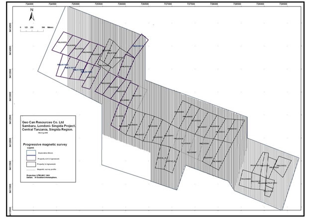
-41-
Based on images produced, there appears to be a northwest-southeast trending vein strike length of more than 5 kilometers. In addition, multiple parallel quartz veins appear to be present and are shown in yellow (Map 20) along with northeast trending mafic dikes. The trend appears to be open to the northwest and to the southeast; the northeast-southwest trending mafic dikes appear to cross-cut the major mineralized structures and may locate a possible open-pit drill target.
Map 20: Total Horizontal Gradient Magnetic Image and Interpreted Quartz Veins
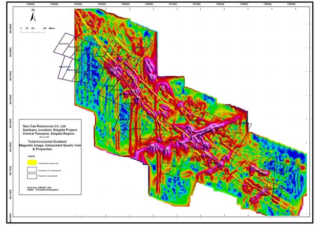
Induced Polarization (I.P.) Survey
The detailed I.P. survey results clearly define the northwest trending vein structures and also appear to show increased structural widths. These images will help define future drill locations. Initial I.P. results are shown below in Map 21 and 22.
-42-
Map 21: Apparent Resistivity, Quartz Veins and Artisanal Shafts over Block C
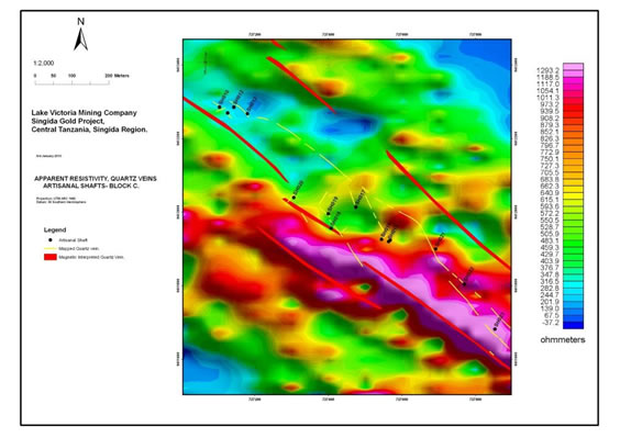
Map 22: Gradient IP, Quartz Veins and Artisanal Shafts over Block C
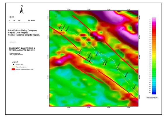
-43-
Sampling Method and Approach
Detailed underground vein and wall rock samples, mine dump samples and artisanal mine tailing samples were collected by Lake Victoria mining company at the Singida gold project. These sample results confirm the presence of multiple veins over at least a five kilometer long strike length.
Mineral Processing and Metallurgical Testing
We collected Singida artisanal mine tailings for gold recovery testing. The recovery tests were conducted at the Resource Development Laboratory, Golden Colorado. The tailing samples assayed 4.65 grams per metric ton gold, and bottle roll leaching tests, after: 6 hours resulted in 74.9 percent gold recovery; 24 hours resulted 81.9 percent extraction; and 48 hours yielded 86.6 percent recovery.
Mineral Resource and Mineral Reserve
Estimates
No
Reserves or Resources are present at this time.
Interpretation and Conclusions
Electrical gradient array IP surveys that commenced in December, 2009 and continued into 2010 (News Release 17 May 2010) indicated that a number of subsurface resistive bodies, thought to represent quartz veins, occur beneath the land surface covering some 400m width of the shear zone and as such would not have been identified by the artisanal miners. In such greenstone belts, the gold bearing quartz veins often occur as en echelon “packages” or “ladder vein sets” that may be formed within or discordant to the shear fabric. These sets often exhibit plunges or “ore shoots” and needed to be accounted for in creating the geological model and incorporated within any subsequent drill program.
During June, 2010, a soil sampling survey was completed across the Singida-Londoni license area in which 483 samples, including 24 quality control blank samples, were collected and submitted to SGS Laboratory, Mwanza for gold and arsenic determination by Aqua Regia. Samples were collected on 400m spaced north-south grid lines at an interval of 50m and at a depth of 30cm. Additional detailed mapping of the geology and location of the artisanal working was also carried out.
The soil sample results, besides indicating areas of known artisanal mining, have formed broad, gold-in-soil anomalies. These gold anomalies are occurring over the areas from which previous electrically induced polarization (IP) geophysical profiling has identified a number of underground resistive bodies, believed to represent gold-bearing quartz veins beneath the surface, as reported in the Company's Press Release of 17th May 2010. The five gold targets, referred to as Sambaru 1 to 5 have surface strike lengths varying between 200 to 600 meters. In addition to assaying for gold, all of the soil samples were tested for arsenic. Arsenic in soil samples can often be a "pathfinder" element for gold when gold itself is not measurably present at surface. In addition to identifying the five targets, the compiled assay results have defined a large arsenic anomaly that is located within the central to northwestern part of the license area and encompasses the Sambaru 4 target, decreasing in intensity towards Sambaru 5 in the northwest corner of the license. Noteworthy is that four IP profile lines, undertaken across the recently identified arsenic anomaly, have indicated at least 8 sub-surface, resistive bodies, thought to be gold-bearing quartz veins, across a surface width of 350 meters.
Mapping of the location of the artisanal shafts within these target areas suggest that mining was undertaken on a number of narrow sub-outcropping gold veins across a surface width of up to 50 meters. However, IP geophysical profiling suggests that these veins may extend further to the northeast beneath the surface cover.
-44-
Detailed mapping of the regolith, topography and soils formed an integral part of the program in order to understand the value of the soil results.
Exploration Strategy
76 reverse circulation (RC) drill holes have been planned totaling nearly 6,000 meters to test the five targets that have been selected. Excavation at drill site locations has commenced and will be followed up shortly with road construction to prepare for drilling that is planned for the late August through September, 2010.
Buhemba Project
The Buhemba Gold Project is comprised essentially of two Prospecting Licenses (PLs), which have been reduced by 50% on renewal of the licenses according to Government regulations. The shed off areas were immediately re-applied as a separate license in order to keep both licenses intact. The total area of the combined licenses amounts to 107km2 (Table 1, Map 2).
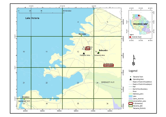
Map 23. Location Map of the Prospecting Licenses Comprising the Buhemba Gold Project
Location and Access
The Buhemba Gold Project is in the administrative district of Musoma. The project is accessible either from the main tarmac road, 203km northwest from Mwanza or 33km south of Musoma town.
Physiographic, Climate, Vegetation and Water
The area is characterized by two rainy seasons: the main rains falling from March to April and a lighter period of rain beginning in October and continuing sporadically through to December. Typically, the annual rainfall averages between 760mm to 1270mm. The Nyagubu and Rwako rivers, flowing westwards into Lake Victoria, drain the project area.
-45-
Topographically, the area is generally undulated with granitic hills in the southern and central parts. The highest point is approximately 1550m above mean sea level in the southeastern part of the project area. Most of the area is covered by subsistence farming of cassava, sorghum and maize. Only the hills and the area underlain with Nyanzian rocks are lightly covered by forest and thick bush.
History
Three areas of colonial/artisanal workings are present on PL4892 and PL2344:
1. Magendagenda consists of 2 shallow workings spaced some 500m
apart along a north-south shear zone.
2. Nyabukamu, located approximately
2km north-northwest of Mgendagenda along the sheared granite/greenstone contact.
3. Kiharagweta, located approximately 1km north-northwest of Nyambaku within
north-south trending quartz vein hosted by an inlier of basaltic rocks.
Rand Gold investigated these PLs between October 2003 to October 2006 in which they undertook regional soil sampling, mapping with follow-up trenching and pitting. Artisanal working defined the main soil anomalies, which lie along a north south to north-northwest by south-southeast, strike direction closely associated with granite/greenstone contact in the south-western part of the license. The artisanal area has been covered by 6 Primary Mining Licenses (PML) having dimensions of 500m x 800m.
Regional Geology
The area is largely underlain by the Archaean Nyanzian Supergroup suite of granitic rocks (the Musoma Series). These have been uncomformably overlain by basal conglomerates (with fragments of Nyanzian rocks), feldspathic grits, argillites, banded iron–formation and minor volcanic rocks of the Kavirondian System.
The central part of PL4892/2007 consists of basaltic rocks of the Nyanzian Supergroup enclosed by younger foliated and unfoliated granites. Shearing has occurred along the western contact of the basaltic rocks and the granite resulting in a number or generations of quartz veins. Chloritization and local silicification, with minor Fe-oxidation is present in the basalt wall rocks. A graphitic metasedimentary unit interbedded within the basalt contains disseminated pyrite and quartz veinlets. The main structural trend within this license lies mainly between the northwest and northeast strike directions.
Exploration Strategy
A field investigation of the work undertaken by Rand Gold has already been completed which has confirmed the presence of at least 4 areas of artisanal workings. Follow-up exploration is planned to target the known areas of artisanal mining as well as to investigate the western sheared basalt/granite contact in PL 4892/2007. Although the PMLs of the artisanal workings do not form part of the PL license, the owners would be amenable to entering a JV agreement. Pole-Dipole traverses are planned across the sheared contact in order to prioritize a follow-up reverse circulation (RC) drilling program expected in September 2010.
No work has yet been undertaken on either of the two licenses PL2979/2005 and PL5159/2009 southeast of Buhemba town (Map 23). Soil sampling on 200m x 50m centers are planned across the license outside the mbuga-covered areas, as well as gradient IP survey and mapping. Results from these will dictate the next phase of exploration.
-46-
Uyowa Project
The Uyowa Gold project consist of a complete package of 7 Prospecting Licenses (PLs) that cover a total area of 900km2 (Table 1) in the central to western side of Tanzania (Map 24).
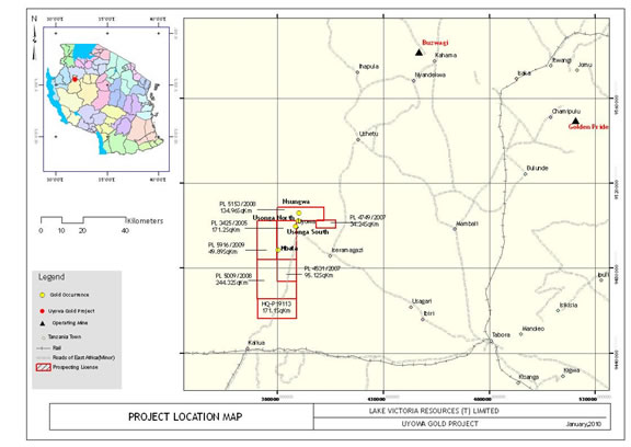
Map 24. Location map showing the Uyowa Prospecting Licenses
Location and Access
Uyowa Project is located in Tabora Region in northwestern Tanzania. It is situated approximately 100km to the NW of Tabora town. A reasonable gravel road connects Tabora with the villages located in the NE corner of the license. Access to the license area is also from Kahama town situated some 110km to the north by a dry seasonal road only. The 20km stretch of this road passes through low-lying ground, which during the rainy season becomes impassable.
Access within the license is by a number of secondary dirt roads and footpaths.
Physiography, Climate, Vegetation and Water
Topographically, the property is relatively flat and is covered by grassland and low scrub other than areas in which subsistence farming is being carried on. The climate is tropically humid with alternating wet and dry seasons.
-47-
History
During 2003-04, Ashanti Goldfields undertook regional exploration across the Uyowa license in which soil sampling on 400m x 100 centers was completed (133 samples). Regional geological and regolith mapping, covering 84km2 and 960km2 respectively, together with a structural interpretation from the Government Aeromagnetic survey were completed. An area of extensive artisanal working occurs in the northern part of the license, which is under license to Primary Mining License (PML) holders. Ashanti Goldfields entered a joint venture agreement with the PML holders in order to explore the prospect. They drilled a total of 13 RC holes (999m) on 40m-spaced fences. Best borehole grades were 5 g/t over 20 m, 3 g/t over 12 m, 85.3 g/t over 1 m, 8.09 g/t over 1 m, and 21.9 g/t over 3m, intersected within 5 gold bearing quartz veins across a strike of 400 m. The artisanal site appears to be located along a 10km shear zone.
Regional Geology
The licenses lie to the southwest of the Nzega greenstone belt within the Archaean Nyanzian Supergroup suite of granitic rocks. The underlying lithologies on the Uyowa license consist mostly of granite. Interpretation of the Government aeromagnetic survey across the license indicates a prominent NE-SW pattern of fractures and lineaments. A large fold nose has been interpreted in the eastern part of the license. Besides the extensive artisanal workings in the northern part of the license, a few artisanal workings are noted in the northern to eastern half of the license. Gold is being mined from narrow quartz veins within discrete shear zones.
Exploration Strategy
An initial site visit was made in July 2010 to the eastern and northern parts of the license to review the current level of artisanal activity as well as take cognizance of the logistics involved in setting up an exploration program in the immediate future. The following exploration strategy is proposed to commence in September 2010.
- Purchase the raw aeromagnetic data from the Government that was flown on a line spacing of 1.0km and at a height of 120m for in-house processing and interpretation
- Infill soil sampling on 200m x 50 centers
- Termitaria sampling
- Gradient IP survey to initially test the structure of the interpreted fold nose on the eastern side of the license and across selected blocks.
Results will decide next phase of exploration (i.e. trenching, pole-dipole IP surveys and drilling)
Kahama Project
The Kahama Project is comprised of the Kahama South and Kahama Shinyanga prospecting licenses consisting of 5 Prospecting Licenses (PLs) that cover a total area of 519km2 (Table 1) in the central to western side of Tanzania (Maps 25 and 26).
-48-
Map 25. Location map of the Kahama South Prospecting Licenses
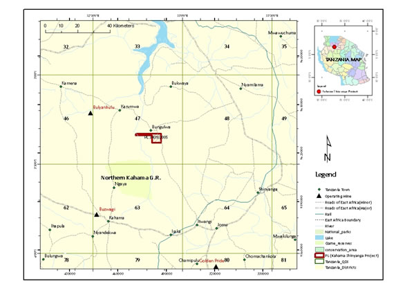
Map 26. Location map of the Kahama Shinyanga Prospecting License
-49-
Location and Access
Although all the licenses occur within the same project area they are 100 kilometres a part. The Kahama Shinyanga license is located some 60km north of the main Kahama–Nzega paved road and 35km to the east of the Bulyanhulu Gold Mine. The license is accessed by the all weather road from the town of Itwapgi, located close to the Kahama-Nzega junction, northwards to the town of Bungulwa. The road passes through the eastern side of the license.
Kahama South licenses are located some 40km to the south-southwest of Kahama town. Access to the licenses is via a number of all weather dirt roads that lead to the village of Ushetu and surrounding villages. Access is also possible from Tabora in the south but is restricted to the dry season only, on account of a large low lying Gombe River drainage basin to the south of the licenses that floods during the wet season.
Physiography, Climate, Vegetation and Water
The area is typically flat lying and is largely covered by “mbuga”. Typical savannah scrubland of grass and scattered thorn bush and acacia trees dominant the landscape. Tobacco and cotton farming are the main cash crops in the area. Access to parts of the license may be difficult during the rainy season and would require the use of a 4X4 vehicle.
History
Geosurvey International flew airborne magnetic and radiometric surveys over the area from 1977-1980. Other than the Government data, no information on exploration undertaken by previous companies is currently available.
Regional Geology
The Archaean Nyanzian Supergroup suite of granitic rocks largely underlies the license areas. Patches of greenstone rocks, comprising of meta-volcanic and meta-sedimentary units occur as patches within the granitic terrain.
Exploration Strategy
Since the Company acquired these licenses, no exploration work has yet been undertaken on them. The projects are basically at “grass-roots” level of exploration and thus have a lower priority rating than many of the other projects within the company portfolio.
An initial field visit to the projects is to be undertaken in order to access the level of artisanal workings present on each of the licenses. Due to the large coverage of “mbuga” soils, detailed ground magnetometer surveys will be undertaken across the entire license from which selected follow up targets for gradient array surveys will be defined. Results of the geophysical programs will determine the next phase of exploration in order to explore beneath the “mbuga” cover.
North Mara Project
The North Mara Project is comprised of twelve (12) Prospecting Licenses (PLs) and have been divided into three (3) project blocks, namely the Tarime North, North Mara Nyabigena East and the Kubiasi-Kiserya areas that cover a total area of 599km2 (Table1) in the northern part of Tanzania (Maps 27, 28 and 29)
-50-
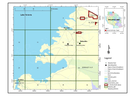
Map 27. Location map of the Tarime North Mara Prospecting Licenses.
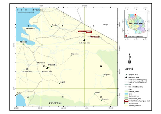
Map 28. Location of the Nyabigena Prospecting Licenses
-51-
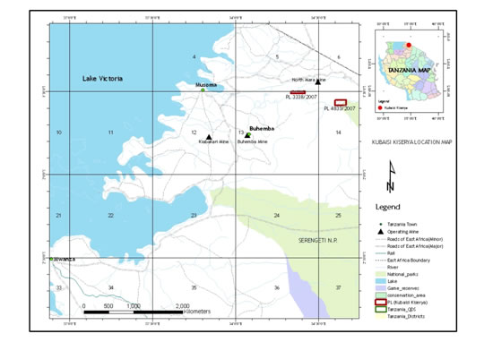
Map 29. Location of the Kubiasi Kiserya Prospecting Licenses
Location and Access
The Tarime gold property (PL2677/2004) is located in northern Tanzania within the Musoma-Mara greenstone belt of the Lake Victoria Goldfield, in Tarime District, Mara Region. The property covers a total of 518.68km 2 in QDS (Quadrangle) 5/1, 2, 3 & 4. Its accessibility is through the Tarime-Musoma road that crosses the property at the southeast corner of the license. Utegi is the major town centre close to 3341/2005. (Map 27)
The Nyabigena licenses (Map 28) located to the east of Tarime and proximal to the Kenya border are largely covered by phonolitic lava that forms the capping of the Nyamwaga Escarpment.
The Kubiasi Kiserya licenses (Map 29) occur to the south of the Nyamwaga Escarpment and North Mara Gold Mine. Both licenses lie on or adjacent to the Mara River and to the north of the Serengeti Game Reserve.
All licenses are easily accessible. The Tarime licenses are accessed via the paved road between Mwanza and Musoma with good secondary roads connecting the various villages on the licenses. All weather gravel roads pass either through or close by the other two exploration areas.
Physiography, Climate, Vegetation and Water
The physiography in the Tarime District is largely flat with black cotton soils (“mbuga”) covering much of the area. Most of the area is grassland and only lightly forested. Rivers are generally intermitted. The climate is tropically humid with alternative wet and dry season.
-52-
Further to the north in the Nyabigena license area, the topography becomes hilly and dark reddish brown soils, developed from the phonolitic lavas, are present. Granite inselbergs dot the plains to the east around the Mara River region in the area of the Kubiasi-Kiserya licenses.
History
North Mara area has a long history of artisanal gold mining. A number of PML’s owned by artisanal miners have been pegged over known gold workings within the Company owned licenses. Exploration undertaken by International recognized companies are not available.
Regional Geology
The North Mara Goldfields is situated within the eastern arm of the Lake Victoria Goldfields. The basement geology is composed of Archean granite, meta-volcanic and meta-sedimentary rocks that make up the greenstone terranes and which form part of the Tanzanian Craton. The geology in the North Mara Region lies within the Nyanzian and Kavirondian Systems.
Exploration Strategy
Since much of the area in the Tarime District is overlain by “mbuga” soils, target generation has to be made from undertaking detailed structural analysis from both Magnetic and IP data. The detailed aeromagnetic survey data undertaken by the Finnish Geological Survey (2003) is to be purchased from the Government and processed. Follow-up gradient array surveys will be focused on magnetically interpreted structural targets. In erosional areas, soil sampling and mapping is be undertaken with focus around artisanal sites on the licenses.
To the east, soil sampling and mapping is planned to explore the Kubiasi Kiserya (PL4833/2007). No exploration is to be undertaken over the prospecting license (PL3338/2007), which straddles the Mara River. This license, together with the Nyabigena (PL4645/2007) located over the Nyamwaga Escarpment, is to be relinquished in the immediate future.
Uranium Projects
Mbinga Project
The Mbinga Uranium Project is comprised of three (3) Prospecting License (Table 2) and two (2) Reconnaissance Licenses (Map 30) The Reconnaissance Licenses, located along the eastern shoreline of Lake Nyasa are currently under application and have not been included within this summary.
-53-
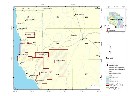
Map 30. Location map of the Mbinga Uranium projects.
Location and Access
The Mbinga properties are located in southern Tanzania near Lake Nyasa in the Mbinga District, of the Ruvuma Region (Map 29). The project is approximately 150 km west of Songea town, the main commercial and administrative centre in the Ruvuma region. The Mbinga Uranium Project covers a total area of 1761km2 located across 4-quarter degree sheets (QDS: 297, 298, 309 and 310). The town of Mbinga is strategically located within the central part of the property, which is 100km southwest of the regional centre of Songea. Generally, the property has poor accessibility and roads within the concessions are limited to a few areas where 4-wheel drive vehicles are required during the rainy seasons. The dirt road along the lakeshore is in reasonable condition. The nearest airport with only irregularly scheduled flights is in Songea town. Another small airstrip exists at Mbinga town.
Physiography, Climate, Vegetation and Water
Steep mountain ridges and valleys, dropping off to flat and low-lying plains around the lakeshore characterize the physiography of the area. Much of the area is under subsistence cultivation. The climate at Mbinga is continental. Generally the Ruvuma Region has mild temperatures averaging 23oC. October and November are the hottest months with an average temperature of 30oC. The rainy season commences in early November and continues through to March. A number of the licenses border the eastern shore of Lake Nyasa (Lake Malawi).
History
Geosurvey International conducted an airborne radiometric and magnetic survey over the area from 1977 to 1980.
-54-
High Resolution Helicopter-Borne Radiometric Survey was contracted to New Resolution Geophysics (NRG) of South Africa in March 2008, to undertake a survey across all licenses at a line spacing of 250m.
Geo Can Resources Company Limited undertook a follow-up ground radiometric survey, in April 2008 on PL4335. Three uranium anomalies were identified which was tested by a number of shallow trenches. Values of >1,000ppm U3O8 were reported from each anomaly.
Regional Geology
The Mbinga properties lie close to the southern part of the Ruhuhu Basin consisting of Karoo rock formations of fluvial-continental origin. The rock of the Ruhuhu Basin unconformably overlies the Usagaran Formation, which comprise of metamorphosed igneous and sedimentary rocks. The rocks at Mbinga are varied and in PL4335/2007 and PL4433/2007 are mainly basement gneisses, granites and granodiorites. In PL4254/2007, the rocks include charnockites, granulites and gneisses.
Two major northwest-southeast trending lineaments traverse the properties.
Property Geology
A total of 117 Uranium point source anomalies have been detected within the property from the Radiometric Interpretation map, sheet 310 (1980). Three mineralized trends have been identified from the Geosurvey’s radiometric total intensity image. The trends include northeast, north-south and northwest directions and are largely reflected by braided drainage channels.
On PL4254/2007, uranium mineralization is associated with small zones of charnokites and cataclastic mylonites in the upland of Mkwaya village as well as in the continental arenaceous sediments of the Karoo system in the northeastern area of the property. To the south, the uranium anomalies correlate with a large stretch of post-orogenic granite that is partly covered with recent sediments.
More than 57 uranium anomalies were identified by the Geosurvey International within and surrounding the property. The most significant anomaly was found to be associated with the north-south trending zone, which parallels the shoreline of Lake Nyasa, on the northern side of the property. The anomaly correlates with dark colored, magnetic mineral bearing sands assumed to be derived from a small zone of garnet-cordierite granulite.
Exploration Strategy
Exploration is to be based on the results obtained from the High Resolution Helicopter-Borne Radiometric Survey. Anomalies shown from the survey are to be prioritized for follow-up ground survey that is to involve mapping and ground scintillometer surveys. Rock chip sampling followed by trenching on prospective targets would be planned before RAB/RC drilling is proposed.
Kiwara Project
The Kiwara Uranium Project is comprised of three (3) Prospecting License (Table 2, Map 31).
-55-
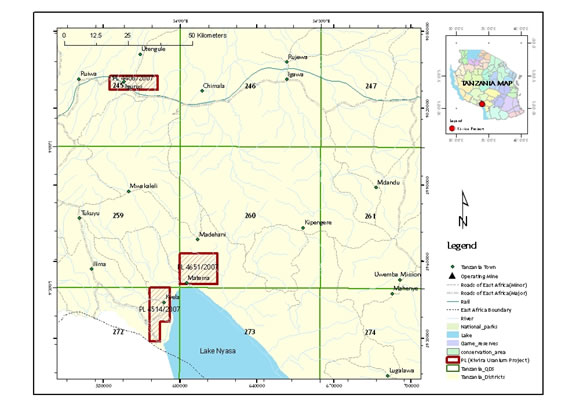
Map 31. Location map of the three Prospecting Licenses that form the Kiwira Uranium Project.
Location and Access
The Kyela-Kiwira properties (PL4651/07 & PL4514/2007) are 120km southwest of the Mbeya, the main town in southern Tanzania. A tar road connects Dar es Salaam to Mbeya. The nearest town to Kiwira property is Kyela town. Access to the property is good.
The Chimala-Igurusi property (PL4406/2007) is 65km northeast of Mbeya and is 25 km southwest of Chimala town in Mbarali District. Access to the property is via the town of Mbarali, located 15 km from license boundary.
Physiography, Climate, Vegetation and Water
The major topographic feature in Kyela-Kiwira property is the rift valley on the northern side of Lake Nyasa. The property sits at an altitude of 1,200 to 1,800m above sea level and typically displays alpine flora.
The Chimala-Igurusi property occurs at lower altitudes, with a flat lying topography in the northern part covered with savannah soils. Hills occur in the southern part of the license. The climate is mainly continental and strongly influenced by the Nyasa plain, with rain (November - May) and dry (June - October) seasons. Prior to the rainy season, the region is characterized by mild winds and dust. In mountainous areas of Kyela-Kiwira area, temperatures are several degrees colder (< 10°C) in June through November. Chimala-Igurusi area has a typical savannah climate characterized by hot temperatures in the dry season and is cold during the wet season.
-56-
History
Initially, Geosurvey International conducted countrywide airborne radiometric and magnetic surveys from 1979 to 1980. This airborne geophysical survey identified several uranium "targets" worthy of further investigations. Fluvial and lacustrine type deposits were identified in the Chimala-Igurusi area as hosts for the uranium mineralization. Ground follow-up has shown banded cherts with Mn-stains that reflect significant radioactivity anomalies.
Unlike Chimala-Igurusi prospect, the Kyela-Kiwira property shows anomalous radiation values located within geological setting dominated by the Karoo sediments of the Selous and Ruhuhu Basins. These sediments are considered to be prospective for sandstone hosted “roll-front” type uranium mineralization.
Regional Geology
The regional geology of the Kyela-Kiwira license is characterized by Paleoproterozoic (2.0 Ga), highly metamorphosed basement rocks, Karoo sedimentary formations and Quartenary volcanic sediments. The basement rocks are made of reworked Archean crust, mainly metamorphic granulites and gneisses. The regional geology of the Igurusi-Chimala is characterized by Paleoproterozoic (1.95 Ga) sediments, which have undergone regional metamorphism and, in some places, have been intruded by granites. These rocks consist of metasediments, micaceous schists, gneisses and migmatites. The area is bounded by the Usangu plains of the Mbarali area. Younger Mesoproterozoic (1.37 Ga) continental argillaceous rocks consisting of reddish and copper rich green shale, quartzites and dolomite and limestone rocks lie conformably on the underlying Paleoproterozoic rocks. These sediments are, in turn, overlain by Quaternary volcanic formations, which cover part of Rungwe and Igurusi-Kongolo area. The basement rocks reflect prominent regional northeast and northwest striking structural lineaments. The area has been structurally complicated by extensive fracture and faulting during the development of the Buhoro and Nyasa basins.
Property Geology
Rock types within the Kyela-Kiwira project consist of three major groups:
| (i) | Late orogenic Paleoproterozoic granites and granodiorites (post 1.95Ga); |
|
| (ii) | Karoo formation of undifferentiated carboniferous terrestrial sandstone, quartzite, siltstone, conglomerate and limestone and often poorly exposed and covered by lake beds underlain by Proterozoic granites; |
|
| (iii) | Nyasa alluvial beds, which comprise of alluvial sediments namely, fine calcareous sands, fine clays, and silts. The sediments cover and fill most of the Kyela-Kiwira property. The late Orogenic granitic rocks consist mostly of hornblende/biotite microgranites with some syenites being reported within the project area. |
The Karoo beds are largely undifferentiated and often poorly exposed and covered by recent Nyasa alluvial sediments. These sediments fill most of Nyasa plains and are poorly consolidated lacustrine deposits. The river valleys contain a patchy distribution of conglomeratic pebbly beds together with considerable amounts of volcanic tuff. The basement Paleoproterozoic rocks consisting of mylonitic migmatites, granulites and quartzites have been cut by a series of northwest trending faults.
The geology of Chimala-Igurusi property consists of assemblage of Paleoproterozoic continental sediments with lavas that lie unconformably on the Archean (>2.5 Ga.) basement metamorphic rocks. Younger gabbroic intrusive rocks are common and have formed a series inselbergs that transect the continental rocks in the southwestern and central Chamoto Hill area.
-57-
Horizontally bedded sedimentary rocks, comprising of colluviums and alluvial gritty sands cover most of the property. Alluvial clays intercalated with colluviums cover the northeastern part of the license. Siliceous clays are found north and east of Chamoto Hill. The structural set-up of Chimala-Igurusi prospect is a series of complicated intrusive gabbros, extensive fracture jointing and faulting. The argillitic rocks, namely shale have been folded with fold axes plunging to the south.
Exploration Strategy
In order to define possible drill targets, the first phase of proposed exploration will be to:
- Undertake detailed mapping,
- Sampling and ground radiometric survey
Success of this first phase will lead to an understanding of the location and extension of the anomalous radioactive trends from which second phase can be initiated:
- Shallow RAB drilling
- Prioritize targets
- Trenching and detailed ground sampling
- RC/Diamond drilling on specified targets with the focus to obtain initial mineral resource estimates.
Njombe Project
The Njombe Uranium Project is comprised of one (1) Prospecting and Reconnaissance License (Table 2, Map 32).
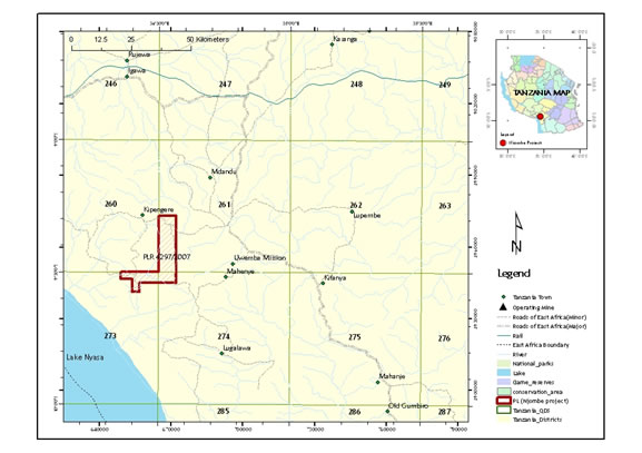
Map 32. Location map of the Njombe Uranium Project.
-58-
Location and Access
Njombe property is centrally located at the junction of survey sheets in the QDS 260, 261, 273 and 274. The town of Njombe is situated 25km to the east of the property (Map 32). The property is surrounded by numerous small villages. Road access is restricted to a network of dirt roads and tracks that require 4X4 vehicles to access the property during the rainy season.
Physiography, Climate, Vegetation and Water
The topography is dominated by gently rolling grass covered ridges and valleys in the northern parts which develop into sandy plains to the south.
The climate at the property is mainly continental and strongly influenced by the high elevation of the area, which is generally between 1500m and 2300m above sea level. The region is also characterized by strong wind and dust. Temperatures are often several degrees colder. Fog occurs during the winter season. Precipitation is moderate.
History
Geosurvey International undertook an airborne magnetic, radiometric and VLF-EM survey across the area from 1997-1980. Geo Can Resources Company Limited undertook an assessment of the data in 2007, which defined the existence of elevated uranium values following a northwest trend through the middle of the license.
Regional Geology
The Ubendian System consisting of proterozoic quartz-feldsparthic granular gneiss, migmatite, underlies geology of the area and amphibolite rocks. The northeast part of the license is dominated by palaeoproterozoic granitoid consisting essentially of late- to post-orogenic granite and granodiorite. Recent alkaline volcanic rocks are found in the northwest part of the license area. The remainder of the license consists of a northwest-southeast trending belt of Mesoproterozoic age metasediments, migmatites and orthogneiss that is interpreted to form part of the Ukingan Group. To the south the Unebian rocks are exposed. Northwest-southeast trending bands of meta-gabbro, anorthosite and ultramafic rocks occur to the west and southwest of the license.
Uranium mineralization is thought to be associated with structural unconformities within the Proterozoic rocks as well as being related to the intrusive granite of the Ilunga series.
Exploration Strategy
Based on the radiometric data obtained by Geosurvey International, a large uranium and thorium anomaly were shown to occur in the northeast part of property that follows a northwest trend through the middle of the license. Follow up exploration is aimed to ground test this anomaly. Mapping and geochemical sampling by a hand held scintillometer will not only provide a geological model for the style of Uranium mineralization but will also assist to prioritize higher grade uranium targets within the anomalous area for follow-up evaluation
Lake Rukwa Project
-59-
The Lake Rukwa Uranium License forms the Rukwa Project, situated to the east of Lake Rukwa (Table 2 and Map 33).
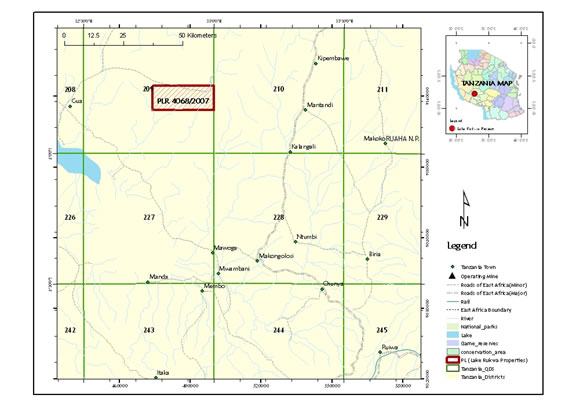
Map 33. Location map of the Rukwa Uranium License that forms the Rukwa Project
Location and Access
The Rukwa Lake project, covering a total of 268.80 km2, is located 45km west of Lake Rukwa and 150km northwest of Mbeya in southwest Tanzania (Map 33). Access to the town of Njombe, located 25km to the east of the property, from Mbeya, is good. Numerous small villages surround the property and road access is restricted to a network of dirt roads and tracks that require 4X4 vehicle usage during the wet season.
Physiography, Climate, Vegetation and Water
The major topographic feature of the property is the Rukwa fault scarp, which follows a northwest trend, from the southeast corner of the property and cutting the northern boundary. The Lukwaiti River, due to the uplift of the fault scarp, has incised into the western corner of the license. Over the remainder of the license the drainage is mature, and "mbuga" soils are developed in the upper reaches of most of the rivers and streams. The country is almost entirely covered with "miombo" forest except for the carbonatite hill lying outside but immediately adjacent to the northern boundary of the license. This hill is grass covered, with dense vegetation growing in the gullies. Thorn bushes and scattered small trees grow over areas where dark-red soils are prevalent.
The climate at the property is mainly continental and strongly influenced by the high elevation of the area, which is generally between 3500 ft (1060m) and 4000 ft (1220m) above mean sea level.
-60-
History
Geosurvey International conducted countrywide airborne radiometric and magnetic surveys over the area from 1979 to 1980 along 1km spaced flight lines. No recent exploration undertaken on the license area is known.
Regional Geology
The property is mostly underlain by syn- and post-orogenic granite and granodiorite. To the north of the license boundary, gneisses and metasediments of the Mesoproterozoic-age Karagwe-Ankolean System dominate the bedrock. A carbonatite plug, referred to as the Rukwa Lake Carbonatite occurs immediately adjacent to the northwest corner of the license and is also reflected as a radiometric anomaly.
Exploration Strategy
Follow-up field investigation into the radiometric anomalies as outlined by Geosurvey International is to take place by mapping and ground radiometric surveys in order to define and prioritize targets for focused exploration.
Mkuju and Mkuju East Project
The Mkuju Uranium Projects comprising of the Mkuju (PLR4644/2007) and Mkuju East (PLR4692/2007), were granted as Prospecting and Reconnaissance Licenses (Table 2, Map 34)
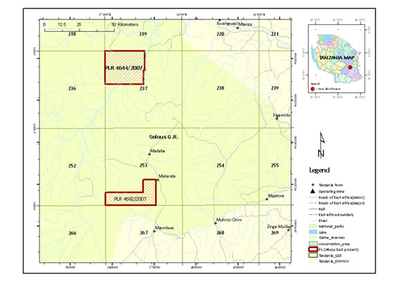
Map 34. Location map of the two Mkuju Licenses, situated within the Selous Game Reserve.
-61-
Location and Access
The Mkuju and Mkuju East licenses are located within the northern and southern parts respectively of the Selous National Game Reserve in the Liwale and Kilombero Districts approximately 210km southwest of Dar Es Salaam town and about 50km north of the town of Madaba. Although a good tarmac road connects Dar to the game reserve, roads within the license area are limited to few areas in which 4X4 vehicles are required during the rainy season.
Physiography, Climate, Vegetation and Water
The Mkuju area appears as an erosional window with a well-developed dendritic drainage pattern within a large mesa plain. The Rufiji River divides the Mkuju license. The Vegetation consists of scrub bush, elephant grass and a few hardwood trees, although the mesa areas may be covered by thick forest. Since this is a game reserve, there are no villages present.
History
Geosurvey International undertook an airborne magnetic, radiometric and VLF-EM survey over the area from 1977 to 1980. No other known work has been undertaken on the properties.
Regional Geology
The western half of the Mkuju license is underlain by basement metamorphic rocks of the Mozambique Belt. Elsewhere in the region and on the Mkuju East license the basement rocks are overlain by continental and marine sedimentary formations of the Karoo System, which essentially form the Selous Sedimentary Basin. The Selous Rift Basin extends over 550km in length and has a width of up to 180km. Significant areas of the license are covered by recent colluviums. The Madaba uranium occurrences are found within the very coarse-grained felspathic sandstones with minor interbedded siltstones of the Karoo Formation.
During 1980 Uranerzbergbau commenced drilling at Madaba and completed 23 diamond holes, which delineated a 4km by 300m zone of mineralization. Three 500m-spaced drill fences of percussion holes outlined a resource of 700 tons of U3O8 .
Exploration Strategy
It has recently been decided by the Company that these two licenses should be relinquished back to the Government due to the fact that they lie within a National Game Reserve. Not only are there inherent problems in undertaking exploration in the park, but the chances of being able to obtain a mining license to exploit any future discovered resource are slim.
ITEM 3. LEGAL PROCEEDINGS.
We are presently not a party to any litigation.
ITEM 4. SUBMISSION OF MATTERS TO A VOTE OF SECURITY HOLDERS.
During the fourth quarter, there were no matters submitted to a vote of our shareholders.
-62-
PART II
ITEM 5. MARKET PRICE FOR THE REGISTRANT’S COMMON EQUITY, RELATED STOCKHOLDER MATTERS AND ISSUER PURCHASES OF EQUITY SECURITIES.
Our shares are traded on the Bulletin Board operated by the Federal Industry Regulatory Authority under the symbol “LVCA.” A summary of trading by quarter for 2010 and 2009 fiscal years are as follows:
| Fiscal Year | ||
| 2010 | High Bid | Low Bid |
| Fourth Quarter 1-01-10 to 3-31-10 | $ 0.65 | $ 0.33 |
| Third Quarter 10-01-09 to 12-31-09 | $ 1.46 | $ 0.56 |
| Second Quarter 7-01-09 to 9-30-09 | $ 0.98 | $ 0.50 |
| First Quarter 4-01-09 to 6-30-09 | $ 0.58 | $ 0.42 |
| Fiscal Year | ||
| 2009 | High Bid | Low Bid |
| Fourth Quarter 1-01-09 to 3-31-09 | $ 0.62 | $ 0.34 |
| Third Quarter 10-01-08 to 12-31-08 | $ 1.20 | $ 0.55 |
| Second Quarter 7-01-08 to 9-30-08 | $ 1.22 | $ 0.44 |
| First Quarter 4-01-08 to 6-30-08 | $ 0.90 | $ 0.02 |
RECENT SALES OF UNREGISTERED EQUITY SECURITIES
From April 1, 2009 to July 14, 2010 we have not sold any equity securities that were not registered under the Securities Act of 1933 that were not previously reported in a quarterly report on Form 10-Q or in a current report on Form 8-K, except as follows:
On January 21, 2009 Lake Victoria issued into an option to purchase prospecting license agreement with Geo Can Resources Ltd. to acquire prospecting license PL2806/2004 at Geita area in Geita District. The total consideration includes an aggregate cash payment of $200,000 and issuance of 5,500,000 shares of common stock. On February 13, 2009, the Company issued 4,000,000 shares of common stock at a fair value of $1,840,000. These shares were subsequently cancelled as a part of the reverse acquisition with Kilimanjaro. The Company issued these shares to a non-U.S. person (as that term is defined in Regulation S of the Securities Act of 1933) in an offshore transaction relying on Regulation S and/or relying on Section 4(2) of the Securities Act of 1933.
On April 15, 2010, the Company issued 153,525 restricted shares of common stock and $21,265, for geological and business development services provided by a consultant. The services were valued at $71,265. The Company issued these shares to an accredited investor relying on Regulation D and/or Section 4(2) of the Securities Act of 1933.
On April 15, 2010, the Company issued 85,000 restricted shares of common stock for consulting and business development services provided by a consulting company. The services were valued at $27,200. The Company issued these shares to a non-U.S. person (as that term is defined in Regulation S of the Securities Act of 1933) in an offshore transaction relying on Regulation S and/or relying on Section 4(2) of the Securities Act of 1933.
As of May 19, 2010, the Company completed a private placement of 10,473,000 units at $0.20 per share for total consideration of $2,063,100 and subscription receivable of $20,000, net of cost of $11,500. Of this, 7,343,650 units were sold for cash consideration of $1,448,730 as of March 31, 2010. Each Unit consists of one share of common stock and one redeemable warrant. One redeemable warrant and payment of $1.25 entitles the holder to purchase one additional share of common stock. The exercise period of the redeemable warrants is thirty-six months from January 28, 2010. Included in the private placement were 1,350,000 units issued to three directors and officers for $270,000.
-63-
The Company sold these units to 5 non-U.S. persons (as that term is defined in Regulation S of the Securities Act of 1933) in offshore transactions relying on Regulation S and/or relying on Section 4(2) of the Securities Act of 1933.
Cash Dividends
As of the date of this report, we have not paid any cash dividends to stockholders. The declaration of any future cash dividend will be at the discretion of our board of directors and will depend upon our earnings, if any, our capital requirements and financial position, our general economic conditions, and other pertinent conditions. It is our present intention not to pay any cash dividends in the foreseeable future, but rather to reinvest earnings, if any, in our business operations.
Section Rule 15(g) of the Securities Exchange Act of 1934
Our shares are covered by section 15(g) of the Securities Exchange Act of 1934, as amended that imposes additional sales practice requirements on broker/dealers who sell such securities to persons other than established customers and accredited investors (generally institutions with assets in excess of $5,000,000 or individuals with net worth in excess of $1,000,000 or annual income exceeding $200,000 or $300,000 jointly with their spouses). For transactions covered by the rule, the broker/dealer must make a special suitability determination for the purchase and have received the purchaser’s written agreement to the transaction prior to the sale. Consequently, the rule may affect the ability of broker/dealers to sell our securities and also may affect your ability to sell your shares in the secondary market.
Section 15(g) also imposes additional sales practice requirements on broker/dealers who sell penny securities. These rules require a one page summary of certain essential items. The items include the risk of investing in penny stocks in both public offerings and secondary marketing; terms important to in understanding of the function of the penny stock market, such as “bid” and “offer” quotes, a dealers “spread” and broker/dealer compensation; the broker/dealer compensation, the broker/dealers duties to its customers, including the disclosures required by any other penny stock disclosure rules; the customers rights and remedies in causes of fraud in penny stock transactions; and, the FINRA’s toll free telephone number and the central number of the North American Administrators Association, for information on the disciplinary history of broker/dealers and their associated persons.
Securities authorized for issuance under equity compensation plans
We do not have an equity compensation plans and accordingly we do not have securities authorized for issuance hereunder.
ITEM 6. SELECTED FINANCIAL DATA.
We are a smaller reporting company as defined by Rule 12b-2 of the Exchange Act and are not required to provide the information required under this item.
ITEM 7. MANAGEMENT’S DISCUSSION AND ANALYSIS OF FINANCIAL CONDITION AND RESULTS OF OPERATIONS.
This section of the annual report includes a number of forward-looking statements that reflect our current views with respect to future events and financial performance. Forward-looking statements are often identified by words like: believe, expect, estimate, anticipate, intend, project and similar expressions, or words which, by their nature, refer to future events. You should not place undue certainty on these forward-looking statements, which apply only as of the date of this report. These forward-looking statements are subject to certain risks and uncertainties that could cause actual results to differ materially from historical results of our predictions.
-64-
During January 2010, the Company ’s management reevaluated its accounting treatment of the presentation of its business combination and the related relationships with related parties. The Company has made several changes to the narrative sections of the filings and restated its financial statements to conform to our understanding of the relative effects of this reevaluation.
Kilimanjaro Mining Company Inc (“Kilimanjaro”) initially classified their ownership in Lake Victoria as a temporary investment. The securities were classified as available for sale and reported at fair value. The investment was revalued at each reporting period to fair value and the gain/loss on investment was recorded as other comprehensive income. The management of Kilimanjaro re-evaluated that Kilimanjaro’s control position during the transition period and determined Kilimanjaro and its control group retained permanent control of Kilimanjaro and its subsidiary throughout the periods presented. Although Kilimanjaro’s investment was temporarily diluted, the investors were passive investors and management and the directors retained control of Kilimanjaro through the subsequent acquisition. The financial statements have been presented to fully disclose this method of accounting.
On August 7, 2009, Kilimanjaro and Lake Victoria completed the Securities Exchange Agreement (the “Acquisition”) under which Lake Victoria acquired all of the issued and outstanding common shares of Kilimanjaro. The stockholders of Kilimanjaro received shares representing approximately 67% of Lake Victoria’s issued capital shares. Since the stockholders of Kilimanjaro own a majority of the outstanding shares of the common stock of Lake Victoria, the Acquisition was accounted for as a “reverse acquisition restructuring” and recapitalization, whereby Kilimanjaro is the accounting acquirer for financial statement purposes which includes the complete financial information on its controlled subsidiary which was Lake Victoria. Additionally, Kilimanjaro and Lake Victoria were under common control since each of the entities’ inception. Accordingly, the two entities were consolidated for all periods since its inception.
Results of Operations
For the twelve months ending March 31, 2010 compared to the twelve months ending March 31, 2009:
For the twelve months ending March 31, 2010, we recorded a net loss before attribution of the non-controlling interest of $8,034,469. After attribution of the non-controlling interest of $1,927,226, the loss attributed to the Company was $6,107,243, or $0.12 per share compared to a net loss for the corresponding period of 2009 of $1,401,281 or $0.06 per share. All discussions of expenses reflect no attribution to the non-controlling interest.
General and administrative expense for the twelve months ending March 31, 2010 increased by $1,364,037 to $1,455,998 compared to $91,961 for the same period in 2009.
Property acquisition costs during the 2010 twelve months period decreased by $2,529,689 to $3,935,611 compared to $6,465,300 in 2009.
Exploration costs during the 2010 twelve months period decreased by $210,357 to $803,810 as compared to $1,014,167 for the same period of 2009.
Consulting fees for the twelve months ended March 31, 2010 increased to $1,455,922 compared to $425,173 for the same period of 2009.
-65-
Management and director fees in the 2010 period increased to $198,017 compared to $120,500 in 2009.
As of May 19, 2010, the Company completed a private placement of 10,473,000 units at $0.20 per share for total consideration of $2,063,100 and subscription receivable of $20,000, net of cost of $11,500. Of this, 7,343,650 units were sold for cash consideration of $1,448,730 as of March 31, 2010. Each Unit consists of one share of common stock and one redeemable warrant. One redeemable warrant and payment of $1.25 entitles the holder to purchase one additional share of common stock. The exercise period of the redeemable warrants is thirty-six months from January 28, 2010. Included in the private placement were 1,350,000 units issued to three directors and officers for $270,000.
On December 31, 2009, the Company completed a private placement of 2,701,001 units at $0.60 per unit for cash of $1,574,704, net of cost of $45,900. Each unit consists of one share of common stock and one redeemable warrant. Two redeemable warrants and payment of $1.25 entitles the holder to purchase one additional share of common stock. The exercise period of the redeemable warrants is thirty-six months from September 9, 2009. As of September 30 and December 31, 2009, the Company received $120,000 and $1,454,704, respectively.
On November 9, 2009, we incorporated Lake Victoria Resources (T) Limited, in Tanzania, as a wholly owned subsidiary corporation to conduct exploration and mining activities on all of our mineral properties.
On July 8, 2009, Kilimanjaro Mining Company, Inc. and Lake Victoria Mining Company, Inc. entered into a Securities Exchange Agreement (the “acquisition”) under which Lake Victoria acquired all of the issued and outstanding common shares of Kilimanjaro. Prior to the acquisition, Lake Victoria was a registrant with the Securities and Exchange Commission and a consolidated subsidiary of Kilimanjaro. Kilimanjaro and Lake Victoria had been under common control since each of the entities’ inception. The acquisition was completed on August 7, 2009 and the stockholders of Kilimanjaro received approximately 67% of the Company’s issued capital shares. The acquisition was accounted for as a “reverse acquisition restructuring” and recapitalization of Kilimanjaro. As the result of this transfer, the former stockholders of Kilimanjaro owned a majority of the outstanding shares of the common stock of the Company, and Kilimanjaro was treated as the accounting acquirer for financial statement purposes. Since Lake Victoria was a consolidated subsidiary of Kilimanjaro, all of the historical accounting information previously reported by the registrant is incorporated in the historical financial information of the Company’s consolidated financial statements. Accordingly, the two entities consolidation reflects all of the historical financial information without any modification for recognition of fair value adjustments based upon a business combination. The equity of Kilimanjaro for accounting purposes was restated in the legal framework of its previously controlled subsidiary Lake Victoria. The continuing legal entity is Lake Victoria Mining Company, Inc. and all equity information has been restated under its share structure and the continuing accounting of the consolidated results of operations are based upon Kilimanjaro’s consolidation of financial information from inception.
Plan of Operation
Our exploration objective is to find an economic mineral body containing gold. Our success depends upon finding mineralized material. This includes a determination by our contracted consultants and professional staff whether the property contains resources and/or reserves. Mineralized material is a mineralized body, which has been delineated by appropriate spaced drilling or underground sampling to support sufficient tonnage and average percentage grade of metals to justify removal. If we don’t find mineralized material or we cannot remove mineralized material, either because we do not have the money to do so or because it is not economically feasible to do so, we will cease operations and you could lose your investment.
In addition, we may not have enough money to complete exploration of our properties. If it turns out that we have not raised enough money to complete our exploration program, we will try to raise additional funds from another public offering, a private placement or loans. At the present time, we are attempting to raise additional money, but there is no assurance that we will be successful. If we need additional money and can’t raise it, we will have to suspend or cease operations until we succeed in raising additional money.
-66-
We must continue to conduct exploration to determine what amount of gold and other minerals, if any, exist in our properties and if any minerals which are found can be economically extracted and profitably processed. We contracted with Geo Can Resources Company Limited (“Geo Can”), which is a contract services exploration company in Tanzania, East Africa, to perform exploration services on all our properties. All exploration and payment commitments as per agreements between Geo Can and the Company for the Geita, Kinyambwiga and Kalemela projects were cancelled as part of the agreement between Geo Can and Kilimanjaro prior to the August 7, 2009 share exchange agreement. Both companies have mutually agreed that the exploration agreements were terminated in November 2009 when the Company incorporated its own exploration subsidiary, Lake Victoria Resources (T) in Tanzania.
PROJECTS
On May 4, 2009, Kilimanjaro completed a Property Acquisition Agreement with Geo Can Resources Company Limited (“Geo Can”). Under the terms of the agreement Kilimanjaro acquired a 100% interest of the mineral property assets of Geo Can which included 33 gold prospecting licenses and 13 uranium licenses. Geo Can had entered into property agreements regarding some of these resource properties with Lake Victoria before the share purchase agreement and now Geo Can no longer has any interest in those prior property agreements.
The May 4, 2009 Property Acquisition dramatically increased our prospecting property portfolio in Tanzania overnight. All of the Company’s mineral property interests are located in Tanzania. Geo Can holds resource properties in trust for Kilimanjaro. Most of the resource property interests are still formally registered to Geo Can to save on registration fees until the annual filing for each property comes due at which time the formal registration of each property will be transferred to Kilimanjaro or as directed by Kilimanjaro.
Our exploration focus throughout this reporting period was on advancing Kinyambwiga and Singida gold projects. This will continue in 2010 and we plan to commence initial exploration on our other projects in conjunction with continuing to advance these two projects.
Kalemela Gold Project
Kalemela project is comprised of PL2747/2004, PL2910/2004, PL3006/2005, PL2892/2009, PL5912/2009 and PL5988/2009 totaling approximately 253.80 sq. km. The first event that occurred, on April 1, 2007, was the acquisition of the prospecting license, PL2747/2004 from Uyowa Gold Mining and Exploration Company Limited, P.O. Box 3167, Dar es Salaam, Tanzania. Kalemela Gold Project license number: PL2747/2004 is located within the Southeastern Lake Victoria Goldfields in Northern Tanzania in Magu District, Mwanza Region and is approximately 125 kilometers northeast of Mwanza. This was followed by a physical examination of the property by Dr. Roger A. Newell, a geologist, our president and director. The license is recorded in Geo Can’s name. Following the initial examination, we entered an Exploration Services Agreement with Geo Can to conduct geologic mapping, soil and rock sampling and ground magnetic surveys.
Subsequently, on November 18, 2008 we acquired two adjacent and contiguous licenses PL3006/2005 and PL2910/2004. We expanded our mineral exploration budget with Geo Can to complete a similar initial exploration program that was conducted on PL2747/2004. We have completed the initial exploration of PL3006/2005 and PL2910/2004. The three licenses totaled about 260 square kilometers. Results of geologic mapping, ground magnetic surveying and soil and rock sampling have identified exploration sites suitable for electrical induced polarization (I.P.) geophysical surveys to further define possible drill targets. Depending on available resources and project scheduling, follow up soil sampling will be conducted to confirm previous sampling results, followed by a targeted electrically induced polariztion (I.P.) geophysical survey and a possible initial drill program. No additional work was conducted on the Kalemela project during this reporting period.
-67-
State Mining Project
On December 22, 2008, we completed an “Option to Purchase Prospecting Licenses Agreement” with Geo Can for PL4339/2006 and PL2702/2004. Under the terms of the agreement and the consideration paid, we will acquire the exclusive and irrevocable option to acquire from the State Mining Corporation a 90% undivided interest in PL4339/2006 and PL2702/2004 through the Geo Can Option. Dr. Roger A. Newell and Mr. Ahmed Magoma completed a field visit to PL2702 and PL5469 on January 19th 2009. Shallow iron stained artisanal mine pits are present and these pits reveal 0.5 meter to 1 meter thick northeast striking and steeply dipping quartz veins. Evidence of earlier RAB drilling was also observed. Plans and budgets for the mineral exploration program on these properties were prepared with the intent for the program to be conducted during the last two quarters of 2009.
On August 10, 2009, the Company decided to release the above three licenses and transferred them back to State Mining Company on August 11 and September 15, 2009. The Company has abandoned its interests in this project and will not be involved any further exploration activities.
Geita Project PL2806/2004 and PL5958/2009
On January 27, 2009, we executed a definitive Option Agreement (the “Option”) with Geo Can to earn a 50% interest in Geo Can’s Geita Gold Project, Prospecting License Number PL2806. Under the terms of the Option, we acquired a 50% interest in the “Property” totaling 43.77 sq km. The “Option” also provides for the Company to acquire, through “Remaining Interest Options,” up to a 75% interest in the gold project. The Geita Gold Project (License number: PL2806/2004) is located in Northern Tanzania within the Lake Victoria goldfields in the Geita District, Mwanza Region. This license is approximately 300 meters south of AngloGold-Ashanti’s world-class Nyankanga gold deposit, about 6 kilometers west of the town of Geita and about 78 kilometers west of Mwanza. The original prospecting license PL2806 has been divided and the project is now comprised of two licenses: PL2806/2004 – 21.59 sq.km. and PL5958/2009 – 20.85 sq.km. which totals about 42.44 sq.km.
During 2008 Geo Can completed detailed ground magnetic surveys, and both reconnaissance and detailed electrical prospecting (induced polarization, I.P.) surveys. Following this work, we commenced drilling on the Geita Project in January, 2009 and completed 37 reverse circulation drill holes for a total of 3,508 meters (11,506 feet). The drilling identified sub-economic gold values; the best mineralized intersection was 2 meters of 3.03 grams per metric ton from 50 meters to 52 meters in drill hole GR-15. The geophysical and geological information continues to be reviewed to determine if additional exploration targets exist that justify additional work. No additional work was conducted on the project during this reporting period.
Kinyambwiga Gold Project
The Kinyambwiga Gold Project is about 208 kilometers northeast of the city of Mwanza in northern Tanzania. On April 2, 2009 we completed an “Option to Purchase Prospecting Licenses Agreement” with Geo Can for PL4653/2007. Under the terms of the agreement and the consideration paid, we will acquire the exclusive and irrevocable option to acquire from Geo Can an 80% undivided interest in PL4653/2007. Previous exploration work completed included: geological and regolith mapping, ground magnetics at 200m grid, geochemical soil sampling at 200X50 grid, trenching, pitting and 6000 meters of RAB and 1300 meters of RC drilling. A detailed ground magnetic survey at 50m grid spacing was completed on a portion of the prospecting license, and on June 4th, 2009 we began to excavate exploration trenches to further expose previously identified quartz veins. Over 50 trenches have been excavated and rock samples from the trenches have been submitted to an assay laboratory. Detailed ground magnetic surveying suggested that the previously identified quartz veins have a strike length of at least one kilometer. A detailed trenching program further defined the quartz veins, and 134 samples collected from 22 trenches averaged 2.28 grams per metric ton. An additional 24 bulk samples were selected for leach assaying these samples returned and average of 3.48 grams per metric ton. Routine fire assays for these same 24 bulk samples averaged 3.56 grams per metric ton. Previous excavations and shallow reconnaissance drilling suggests that multiple veins are present and may extend over a 2 kilometer distance. Additional RC and core drilling may be planned to confirm these assay results at depth below selected trenches and artisanal mine workings.
-68-
Singida Gold Project
Company personnel first visited the Singida project area during March, 2009 and became aware of the high level of artisanal (small scale) gold mining that was being conducted along an estimated five (5) kilometer mineralized zone. Subsequently, on May 15, 2009, the Company signed a Mineral Financing Agreement with one director of the Company authorizing him, on behalf of the Company, to acquire Primary Mining Licenses (“PMLs”) in the Singida area. As of March 31, 2010, this director has entered into several different Mineral Properties Sales and Purchase agreements with multiple PML owners that hold title to the licenses along the mineralized zone at the Singida project area. Twenty-three (23) PML agreements were executed for an outright purchase of the PMLs and they have been completed. These twenty-three PMLs have been 100% acquired by this director in behalf of the Company. The Company also has option agreements to acquire an additional thirty-seven (37) PMLs within a targeted area at the Singida project. Under the terms of all the agreements, if we complete all sixty (60) of the various agreements, that combined form the Singida project area, then our total purchase consideration will be $7,029,404 by February, 2013.
At the option of the Company, we may relinguish any PML at any time during the agreement and transfer the title back to the original owner. Also, at the option of the Company, a 2% Net Smelter Production royalty or 2% of the Net Sale Value may be substituted in place of the final payment for each PML and paid on a pro rata basis determined by the total final number of PMLs involved in a special mining license.
On October 27, 2009, the Company signed and renewed a Mineral Properties Purchase Financing Agreement with one director of the Company which replaced the initial agreement with Kilimanjaro Mining on May 15, 2009. According to the renewed agreement, the Company shall provide all the finances required for acquiring and developing the PMLs in the Singida Project area and the Company will continue to have a 100% beneficial interest in all PMLs acquired by the director pursuant to the initial and renewed agreement.
On January 19, 2010, a director on behalf of the Company signed second addendums to Singida mineral properties sales and purchase agreements (“mineral agreement”) in 2009. The addendums revised and extended the secondary payments of the mineral agreements.
As of March 31, 2010, under the terms of the mineral properties sales and purchase agreements the Company has completed initial option payments in the amount of $904,148 and $61,482 is accrued as a short term liability.
The Singida Gold Project lies about 600 kilometers south of the city of Mwanza. The Singida project is the location of active artisanal mining and we have conducted detailed underground sampling, sampling of artisanal mine waste dumps and processed tailing piles. More than 8,200 samples have been collected and assayed. From 36 mine shafts and connected workings, over a strike length of about 5km, 176 samples averaged 7.1 grams per metric ton; assays for 1,138 samples from artisanal mine dumps located at surface and containing about 20,000 tons average about 2.14 g/t; the amount of gold present in the dumps is about 1,370 ounces. An additional number of dumps are present that contain an estimated 70,000 tons. Assay results from 2,478 tailing samples were also received; an initial 75 processed tailing piles contain about 20,000 tons with an average grade of 3.05 g/t. An additional 22 processed tailing piles contain about 6,000 tons with an average of 6.78 g/t gold. The estimated contained gold is about 1,900 ounces and 1,300 ounces respectively. Together there are about 26,000 tons of tailings containing about 3,200 ounces of gold. A detailed ground magnetic survey, at 25 meter grid spacing, was conducted over the mineralized area which appears to extend in a northwest – southeast direction for a distance of 5 kilometers or more. The mineralized zone consists of quartz veins varying from about 0.3 to 2 meters thick in greenstone rocks, and the sampled artisanal mine shafts averaged about 50 meters deep. Additional work is planned at Singida which may involve I.P. surveying and drilling below the artisanal workings to confirm mineralization at depth below the current workings.
-69-
Additional Considerations
We are searching for mineralized material. Mineralized material is a mineral body, which has been delineated by appropriate spaced drilling or underground sampling to support sufficient tonnage and average grade of metals to justify removal. Before mineral retrieval can begin, we must explore for and find mineralized material. After that has occurred we have to determine if it is economically feasible to remove the mineralized material. Economically feasible means that the costs associated with the removal of the mineralized material will not exceed the price at which we can sell the mineralized material. We can’t predict what that will be until we find mineralized material.
We do not know if we will find mineralized material. We believe that activities occurring on adjoining properties are not material to our activities. The reason is that whatever is located under adjoining property may or may not be located under our property.
We have exploration licenses. We do not have a license to mine any minerals or reserves whatsoever at this time on any part of our properties. Once exploration has advanced to a point where mining on one or more of our properties is feasible, we plan to apply for a mining license or licenses.
We may interest other companies in our properties if we find mineralized materials. Depending on the discovery, we may try to develop the reserves ourselves and through the use of contracted consultants. Our portfolio of projects is very large and we may interest other companies in properties to participate in the exploration of them, through option or joint venture agreements to find mineralized material.
If we are unable to complete any phase of exploration because we don’t have enough money, we will cease operations until we raise more money. If we can’t or don’t raise more money, we will cease operations. If we cease operations, we don’t know what we will do and we don’t have any plans for future activities.
All of the work on our properties is conducted by contractors that the Company has hired through exploration service contracts or employees hired through Lake Victoria Resources (T) Limited, a wholly owned Tanzania corporation. The contractors are responsible for surveying, geology, engineering, exploration, and excavation. The geologists will evaluate the information derived from the exploration and evaluation and the engineers will advise us on the economic feasibility of removing the mineralized material.
Limited Operating History; Need for Additional Capital
There is no historical financial information about us upon which to base an evaluation of our performance. We are an exploration stage corporation and have not generated any revenues from operations. We cannot guarantee we will be successful in our business operations. Our business is subject to risks inherent in the establishment of a new business enterprise, including limited capital resources, possible delays in the exploration of our properties, possible cost overruns due to price and cost increases for services and economic conditions.
Liquidity and Capital Resources
As of May 19, 2010, the Company completed a private placement of 10,473,000 units at $0.20 per share for total consideration of $2,063,100 and subscription receivable of $20,000, net of cost of $11,500. Of this, 7,343,650 units were sold for cash consideration of $1,448,730 as of March 31, 2010. Each Unit consists of one share of common stock and one redeemable warrant. One redeemable warrant and payment of $1.25 entitles the holder to purchase one additional share of common stock. The exercise period of the redeemable warrants is thirty-six months from January 28, 2010. Included in the private placement were 1,350,000 units issued to three directors and officers for $270,000.
-70-
On December 31, 2009, the Company completed a private placement of 2,701,001 units at $0.60 per unit for cash of $1,574,704, net of cost of $45,900. Each unit consists of one share of common stock and one redeemable warrant. Two redeemable warrants and payment of $1.25 entitles the holder to purchase one additional share of common stock. The exercise period of the redeemable warrants is thirty-six months from September 9, 2009. As of September 30 and December 31, 2009, the Company received $120,000 and $1,454,704, respectively.
As of March 31, 2010 and 2009, the Company has warrants and financing options outstanding to purchase 13,006,651 and 4,312,500 common shares, respectively.
As of March 31, 2010 and 2009, our total assets were $1,559,532 and $482,329, and our total liabilities were $890,919 and $730,711, respectively.
On August 7, 2009 the Company issued 37,653,549 common shares pursuant to a share exchange agreement with Kilimanjaro. Of these shares, 24,478,300 had been issued originally by Kilimanjaro prior to December 31, 2008. The remaining portions of the underlying shares were issued by Kilimanjaro prior to the August 7, 2009 share exchange agreement for the following purposes:
1,747,200 were issued for cash at $0.25
per share
6,211,500 were issued for acquisition of mineral
properties
3,172,042 were issued for payment of consulting services
According to the share exchange agreement, Kilimanjaro, on August 7, 2009, cancelled 4,000,000 common shares held in its subsidiary, Lake Victoria, of which 3,000,000 shares were originally issued to Kilimanjaro and 1,000,000 shares to former directors on March 14, 2007, the inception of the subsidiary. Also in accordance with the share exchange agreement Kilimanjaro, on August 7, 2009, cancelled 6,350,300 common shares in its subsidiary Lake Victoria which included 2,350,300 shares issued on December 23, 2008 and 4,000,000 shares issued on February 13, 2009 to Geo Can Resources Ltd. and acquired in May 2009 by Kilimanjaro.
In January, 2009, Kilimanjaro cancelled 33,600 common shares in the amount of $14,000 due to the request of an individual investor to withdraw his private placement.
Lake Victoria, prior to the share exchange agreement with its controlling parent company, Kilimanjaro, issued the following shares as the reporting registrant and subsidiary of Kilimanjaro:
On April 15, 2009 Lake Victoria granted 70,000 restricted common shares at a fair value of $35,000 to officers and directors. The shares were issued on August 4, 2009.
On February 13, 2009, the Company issued 4,000,000 shares of common stock at a fair value of $1,840,000 in accordance with the January 21, 2009 Option to Purchase agreement for Geita PL 2806/2004. All of these shares were acquired by Kilimanjaro as part of a share exchange in May 2009.
On January 21, 2009 Lake Victoria entered into an option to purchase prospecting license agreement with Geo Can Resources Ltd. to acquire prospecting license PL2806/2004 at Geita area in Geita District. The total consideration includes an aggregate cash payment of $200,000 and issuance of 5,500,000 shares of common stocks.
Recent accounting pronouncements
On February 25, 2010, the FASB issued ASU 2010-09 Subsequent Events Topic 855 "Amendments to Certain Recognition and Disclosure Requirements," effective immediately. The amendments in the ASU remove the requirement for an SEC filer to disclose a date through which subsequent events have been evaluated in both issued and revised financial statements. Revised financial statements include financial statements revised as a result of either correction of an error or retrospective application of U.S. GAAP. The FASB believes these amendments remove potential conflicts with the SEC's literature. The adoption of this ASU did not have a material impact on our consolidated financial statements.
-71-
In January 2010, FASB issued Financial Accounting Standards Update 2010-06, Fair Value Measurements and Disclosures (Topic 820): Improving Disclosures about Fair Value Measurements (“Update 2010-06”). Update 2010-06 is intended to improve disclosures originally defined in accounting standards. Update 2010-06 requires new discloses summarized as follows:
1) Transfers in and out of Levels 1 and 2. A reporting entity should disclose separately the amounts of significant transfers in and out of Level 1 and Level 2 fair value measurements and describe the reasons for the transfers.
2) Activity in level 3 fair value measurements. In the reconciliation for fair value measurements using significant unobservable inputs (Level 3), a reporting entity should present separately information about purchases, sales, issuances, and settlements.
The new disclosures and clarifications of existing disclosures are effective for interim and annual reporting periods beginning after December 15, 2009, except for the disclosures about purchases, sales, issuances, and settlements in the roll forward of activity in Level 3 fair value measurements. Those disclosures are effective for fiscal years beginning after December 15, 2010, and for interim periods within those fiscal years. The Company does not expect the adoption of this standard to have a direct quantitative material impact on its financial position or results of operations.
In January 2010, the FASB issued two ASU's that (1) codify SEC Observer comments made at the June 2009 EITF meeting and (2) make technical corrections to several SEC sections of the FASB Codification. In general, the two ASU's, do not change existing practice. ASU 2010-05, Compensation--Stock Compensation (TOPIC 718)--Escrowed share arrangements and the presumption of compensation, codifies EITF Topic D-110, escrowed share arrangements and the presumption of compensation, which provides the SEC staff's view on when an escrowed share arrangement involving shareholders is presumed to be compensatory and the factors to consider when analyzing whether that presumption has been overcome.
In August 2009, the FASB issued Accounting Standards Update (“ASU”) No. 2009-05, "Measuring Liabilities at Fair Value," which amends ASC 820, "Fair Value Measurements and Disclosures." ASU 2009-05 provides clarification and guidance regarding how to value a liability when a quoted price in an active market is not available for that liability. The Company will adopt the provisions of this update for fair value measurements of liabilities effective October 1, 2009, and adoption is not expected to have a significant impact on the Company’s consolidated financial statements.
In June 2009, the FASB issued SFAS No. 168, “FASB Accounting Standards Codification” (Codification) as the single source of authoritative nongovernmental U.S. GAAP to be launched on July 1, 2009. The Codification does not change current U.S. GAAP, but is intended to simplify user access to all authoritative U.S. GAAP by providing all the authoritative literature related to a particular topic in one place. All existing accounting standard documents will be superseded and all other accounting literature not included in the Codification will be considered nonauthoritative. The Codification is effective for interim and annual periods ending after September 15, 2009. The Codification is for disclosure only and will not impact our financial condition or results of operations. The Accounting Standards Codification (ASC) has become the source of authoritative U.S. generally accepted accounting principles (“GAAP”). The ASC only changes the referencing of financial accounting standards and does not change or alter existing GAAP.
In June 2009, the FASB issued ASC 810-10 (formerly SFAS 167), “Amendments to FASB Interpretation No. 46(R)”. ASC 810-10 amends ASC 810-10 (formerly FIN 46(R)), “Consolidation of Variable Interest Entities,” and changes the consolidation guidance applicable to a variable interest entity (“VIE”). It also amends the guidance governing the determination of whether an enterprise is the primary beneficiary of a VIE, and is, therefore, required to consolidate an entity, by requiring a qualitative analysis rather than a quantitative analysis. The qualitative analysis will include, among other things, consideration of who has the power to direct the activities of the entity that most significantly impact the entity’s economic performance and who has the obligation to absorb losses or the right to receive benefits of the VIE that could potentially be significant to the VIE. This standard also requires
-72-
continuous reassessments of whether an enterprise is the primary beneficiary of a VIE. Previously, ASC 810-10 required reconsideration of whether an enterprise was the primary beneficiary of a VIE only when specific events had occurred. QSPEs, which were previously exempt from the application of this standard, will be subject to the provisions of this standard when it becomes effective. ASC 810-10 also requires enhanced disclosures about an enterprise’s involvement with a VIE. ASC 810-10 will be effective as of the beginning of interim and annual reporting periods that begin after November 15, 2009.
ITEM 7A. QUANTITATIVE AND QUALITATIVE DISCLOSURES ABOUT MARKET RISK.
We are a smaller reporting company as defined by Rule 12b-2 of the Exchange Act and are not required to provide the information required under this item.
ITEM 8. FINANCIAL STATEMENTS AND SUPPLEMENTARY DATA.
-73-
To the Board of Directors and Stockholders of
Lake Victoria Mining Company, Inc.
REPORT OF INDEPENDENT REGISTERED PUBLIC ACCOUNTING FIRM
We have audited the accompanying consolidated balance sheets of Lake Victoria Mining Company, Inc. (an exploration stage company) as of March 31, 2010 and 2009, and the related consolidated statements of operations, stockholders’ equity (deficit) and cash flows for the years then ended and for the period from December 11, 2006 (inception) to March 31, 2010. These consolidated financial statements are the responsibility of the Company’s management. Our responsibility is to express an opinion on these consolidated financial statements based on our audit.
We conducted our audit in accordance with the standards of the Public Company Accounting Oversight Board (United States). Those standards require that we plan and perform the audit to obtain reasonable assurance about whether the financial statements are free of material misstatement. The Company is not required to have, nor were we engaged to perform, an audit of its internal control over financial reporting. Our audit included consideration of internal control over financial reporting as a basis for designing audit procedures that are appropriate in the circumstances, but not for the purpose of expressing an opinion on the effectiveness of the Company’s internal control over financial reporting. Accordingly, we express no such opinion. An audit includes examining, on a test basis, evidence supporting the amounts and disclosures in the financial statements. An audit also includes assessing the accounting principles used and significant estimates made by management, as well as evaluating the overall financial statement presentation. We believe that our audit provides a reasonable basis for our opinion.
In our opinion, the consolidated financial statements referred to above present fairly, in all material respects, the financial position of Lake Victoria Mining Company, Inc. as of March 31, 2010 and 2009, and the results of their operations and their cash flows for the years then ended and for the period from December 11, 2006 (inception) to March 31, 2010, in conformity with accounting principles generally accepted in the United States of America.
The accompanying consolidated financial statements have been prepared assuming that the Company will continue as a going concern. As discussed in Note 2 to the consolidated financial statements, the Company has suffered recurring losses and has an accumulated deficit at March 31, 2010. These factors raise substantial doubt about its ability to continue as a going concern. Management's plans in regard to these matters are also described in Note 2. The consolidated financial statements do not include any adjustments that might result from the outcome of this uncertainty.
BEHLERMICK PS
BehlerMick PS
Spokane,
Washington
July 13, 2010
F-1
-74-
LAKE VICTORIA MINING COMPANY, INC.
(FORMERLY
KNOWN AS KILIMANJARO MINING COMPANY, INC.)
(AN EXPLORATION STAGE
COMPANY)
CONSOLIDATED BALANCE SHEETS
| March 31, | March 31, | |||||
| 2010 | 2009 | |||||
| ASSETS | ||||||
| CURRENT ASSETS | ||||||
| Cash | $ | 955,401 | $ | 530,569 | ||
| Advances and deposits | 4,224 | 3,792 | ||||
| Advances to related party | 499,043 | 1,537,849 | ||||
| Total Current Assets | 1,458,668 | 2,072,210 | ||||
| PROPERTY AND EQUIPMENT, NET | 100,864 | 8,322 | ||||
| TOTAL ASSETS | $ | 1,559,532 | $ | 2,080,532 | ||
| LIABILITIES AND STOCKHOLDERS' EQUITY (DEFICIT) | ||||||
| CURRENT LIABILITIES | ||||||
| Accounts payable | $ | 99,736 | $ | 24,344 | ||
| Accounts payable-related party | 700,523 | 334,914 | ||||
| Acquisition liabilities – related parties | 61,482 | 300,000 | ||||
| Accrued expenses | - | 125,000 | ||||
| Other payables | 29,178 | - | ||||
| Total Current Liabilities | 890,919 | 784,258 | ||||
| COMMITMENTS AND CONTINGENCIES | - | - | ||||
| STOCKHOLDERS' EQUITY (DEFICIT) | ||||||
| Preferred
stock, $0.00001 par
value: 100,000,000 authorized, no shares outstanding |
- | - | ||||
| Common
stock, $0.00001 par
value; 100,000,000 shares authorized 67,871,225 and 26,522,808 shares issued and outstanding, respectively |
679 | 266 | ||||
| Additional paid-in capital | 9,110,183 | 2,935,914 | ||||
| Subscription receivable | (20,000 | ) | (13,280 | ) | ||
| Accumulated deficit during exploration stage | (8,422,249 | ) | (2,315,005 | ) | ||
| 668,613 | 607,894 | |||||
| NON-CONTROLLING INTEREST | - | 688,380 | ||||
| Total Stockholders' Equity (Deficit) | 668,613 | 1,296,274 | ||||
| TOTAL LIABILITIES AND STOCKHOLDERS EQUITY (DEFICIT) | $ | 1,559,532 | $ | 2,080,532 |
The accompanying notes are an integral part of these
consolidated financial statements
F-2
-75-
LAKE VICTORIA MINING, INC.
(FORMERLY KNOWN AS
KILIMANJARO MINING COMPANY, INC.)
(AN EXPLORATION STAGE COMPANY)
CONSOLIDATED STATEMENTS OF OPERATIONS
| For the Year | For the Year | December 11, 2006 | |||||||
| Ended | Ended | (Inception) to | |||||||
| March 31, 2010 | March 31, 2009 | March 31, 2010 | |||||||
| REVENUE | $ | - | $ | - | $ | - | |||
| OPERATING EXPENSES | |||||||||
| General and administrative expenses | 1,455,998 | 91,961 | 1,668,827 | ||||||
| Amortization and depreciation expenses | 10,727 | 2,869 | 13,881 | ||||||
| Professional fees | 1,455,922 | 425,173 | 2,463,671 | ||||||
| Management and director fees | 198,017 | 120,500 | 422,017 | ||||||
| Travel and accommodation | 114,842 | 56,630 | 310,120 | ||||||
| Impairment of mineral property acquisition costs | 3,935,611 | 6,465,300 | 10,400,911 | ||||||
| Exploration costs | 803,810 | 1,014,167 | 1,817,977 | ||||||
| Total operating expense | 7,974,927 | 8,176,600 | 17,097,404 | ||||||
| LOSS FROM OPERATIONS | (7,974,927 | ) | (8,176,600 | ) | (17,097,404 | ) | |||
| OTHER INCOME (EXPENSES) | |||||||||
| Other income from professional services | - | - | 15,900 | ||||||
| Gain (loss) on long-term investments | 10,000 | (5,000 | ) | 5,000 | |||||
| Exchange loss | (70,153 | ) | - | (70,153 | ) | ||||
| Interest income | 1,133 | 4,235 | 5,475 | ||||||
| Interest expense | (522 | ) | - | (522 | ) | ||||
| Total other expenses | (59,542 | ) | (765 | ) | (44,300 | ) | |||
| LOSS BEFORE TAXES | (8,034,469 | ) | (8,177,366 | ) | (17,141,705 | ) | |||
| INCOME TAX EXPENSE (BENEFIT) | - | - | - | ||||||
| NET LOSS | $ | (8,034,469 | ) | $ | (8,177,366 | ) | $ | (17,141,705 | ) |
| LOSS ATTRIBUTABLE TO
NON- CONTROLLING INTEREST |
1,927,226 | 6,776,084 | 8,719,456 | ||||||
| NET LOSS ATTRIBUTABLE TO PARENT | $ | (6,107,243 | ) | $ | (1,401,281 | ) | $ | (8,422,249 | ) |
| NET LOSS PER COMMON SHARE, BASIC AND DILUTED | $ | (0.12 | ) | $ | (0.06 | ) | |||
| WEIGHTED AVERAGE NUMBER OF COMMON
SHARES OUTSTANDING, BASIC AND DILUTED |
49,105,191 | 25,204,200 |
The accompanying notes are an integral part of these
consolidated financial statements
F-3
-76-
LAKE VICTORIA MINING, INC.
(FORMERLY KNOWN AS
KILIMANJARO MINING COMPANY, INC.)
(AN EXPLORATION STAGE COMPANY)
CONSOLIDATED STATEMENTS OF CASH FLOWS
| Period from | |||||||||
| For the Year | For the Year | December 11, 2006 | |||||||
| Ended | Ended | (Inception) to | |||||||
| March 31, 2010 | March 31, 2009 | March 31, 2010 | |||||||
| CASH FLOWS FROM OPERATING ACTIVITIES | |||||||||
| Net loss | $ | (6,107,243 | ) | $ | (1,401,281 | ) | $ | (8,422,249 | ) |
| Adjustments to reconcile net loss to net cash | |||||||||
| Amortization and depreciation | 10,727 | 2,869 | 13,881 | ||||||
| Loss in subsidiary attributed to non-controlling interest | (1,927,226 | ) | (6,776,084 | ) | (8,719,456 | ) | |||
| Impairment of mineral property acquisition costs | 3,935,611 | 6,465,300 | 10,400,911 | ||||||
| Share payments for consulting services | 2,292,623 | - | 2,490,123 | ||||||
| Restructuring charges | (110,029 | ) | - | (110,019 | ) | ||||
| Loss(gain) on other investment | (10,000 | ) | 5,000 | (5,000 | ) | ||||
| Directors' compensation share payments | 35,000 | - | 35,000 | ||||||
| Provided (used) by operating activities: | |||||||||
| Decrease (Increase) in accounts receivable | (423 | ) | (63,792 | ) | (64,218 | ) | |||
| Decrease(Increase) in advances to related party | 978,837 | (500,268 | ) | (499,043 | ) | ||||
| Increase in accounts payable | 500,973 | 640,662 | 860,261 | ||||||
| Increase(Decrease) in accounts payable - related party payable | (238,518 | ) | - | 61,482 | |||||
| Increase (Decrease) in accrued expenses | (125,000 | ) | 48,710 | - | |||||
| Increase (Decrease) in other payables | 29,178 | (79 | ) | 29,178 | |||||
| Net cash used by operating activities | (735,492 | ) | (1,578,964 | ) | (3,929,151 | ) | |||
| CASH FLOWS FROM INVESTING ACTIVITIES | |||||||||
| Acquisition of property, plant, and equipment | (103,269 | ) | (7,706 | ) | (114,745 | ) | |||
| Cash payment for acquisition of mineral properties | (2,135,611 | ) | (585,000 | ) | (2,720,611 | ) | |||
| Proceeds of subsidiary stock issuances | - | 1,500,000 | 1,600,300 | ||||||
| Purchase of investment | - | (5,000 | ) | (5,000 | ) | ||||
| Proceeds from sale of investment | 10,000 | - | 10,000 | ||||||
| Net cash provided(used) from investing activities | (2,228,880 | ) | 902,294 | 1,230,056 | |||||
| CASH FLOWS FROM FINANCING ACTIVITIES | |||||||||
| Proceeds from issuance of stock | 3,389,205 | 851,684 | 6,128,609 | ||||||
| Payment for cancellation of stock | - | - | (14,000 | ) | |||||
| Related party payable proceeds | - | - | 420 | ||||||
| Related party payable payments | - | (420 | ) | (420 | ) | ||||
| Net cash provided by financing activities | 3,389,205 | 851,264 | 6,114,609 | ||||||
| Net increase (decrease) in cash and cash equivalents | 424,832 | 174,594 | 955,401 | ||||||
| CASH AT BEGINNING OF PERIOD | 530,570 | 355,975 | - | ||||||
| CASH AT END OF PERIOD | $ | 955,401 | $ | 530,569 | $ | 955,401 | |||
| SUPPLEMENTAL CASH DISCLOSURES: | |||||||||
| Income taxes paid | $ | - | $ | - | $ | - | |||
| Interest paid | $ | (522 | ) | $ | - | $ | (522 | ) | |
| NON-CASH INVESTING AND FINANCING ACTIVITIES: | |||||||||
| Stock issued for subscription receivable | $ | 20,000 | $ | - | $ | 33,275 | |||
| Investment acquired through payable | $ | 8,000 | $ | 30 | $ | 8,030 | |||
| Receivable exchange for long term investment | $ | 10,000 | $ | - | $ | 10,000 | |||
| Share payments for mineral interest acquisition costs | $ | 1,800,000 | $ | 5,880,300 | $ | 7,680,300 | |||
| Accounts receivable exchange for acquiring mineral interest | $ | 1,039,981 | $ | - | $ | 1,039,981 | |||
| Accounts receivable exchange for long term investment | $ | 460,019 | $ | - | $ | 460,019 |
The accompanying notes are an integral part of these
consolidated financial statements
F-4
-77-
LAKE VICTORIA MINING COMPANY, INC.
(FORMERLY
KNOWN AS KILIMANJARO MINING COMPANY, INC.)
(AN EXPLORATION STAGE
COMPANY)
CONSOLIDATED STATEMENT OF STOCKHOLDERS' EQUITY(DEFICIT)
| Accumulated | |||||||||||||||||||||
| Deficit | Total | ||||||||||||||||||||
| Additional | During | Stockholders’ | Non- | ||||||||||||||||||
| Common Stock | Paid-in | Subscription | Exploration | Equity | Controlling | ||||||||||||||||
| Shares | Amount | Capital | Receivable | Stages | (Deficit) | Interest | |||||||||||||||
| Balance, at December 12, 2006 | - |
$ | - |
$ | - | $ | - | $ | - | $ | - | $ | - | ||||||||
| Common stock issued in December for cash at $0.001 per share |
14,730,000 | 147 | 12,128 | (9,775 | ) | - | 2,500 | - | |||||||||||||
| Common stock issued in February for consulting service provided @ $0.10 per share |
2,370,000 | 24 | 197,476 | - | - | 197,500 | - | ||||||||||||||
| Subsidiary equity interest purchased in March by non-controlling interests |
- | - | - | - | - | - | 10 | ||||||||||||||
| Net loss for period ended March 31, 2007 |
- | - | - | - | (294,102 | ) | (294,102 | ) | (7,441 | ) | |||||||||||
| Balance, at March 31, 2007 | 17,100,000 |
$ | 171 | $ | 209,604 | $ | (9,775 | ) | $ | (294,102 | ) | $ | (94,102 | ) | $ | (7,431 |
) | ||||
| Common stock issued in April for cash at $0.10 per share |
5,172,000 | 52 | 430,948 | (3,500 | ) | - | 427,500 | - | |||||||||||||
| Common stock issued in October for cash at $0.75 per share |
2,201,923 | 22 | 1,375,748 | - | - | 1,375,770 | - | ||||||||||||||
| Common stock issued in November for cash at $0.75 per share |
48,000 | - | 30,000 | - | - | 30,000 | - | ||||||||||||||
| As of October, Subsidiary equity interest purchased by non-controlling interests |
- | - | - | - | - | - | 100,300 | ||||||||||||||
| Miscellaneous adjustments to Equity | - | - | - | (5 | ) | - | (5 | ) | - | ||||||||||||
| Common stock issued in February for cash at $0.75 per share |
60,720 | 1 | 37,949 | - | - | 37,950 | - | ||||||||||||||
| Net loss for period ended March 31, 2008 |
- | - | - | - | (619,622 | ) | (619,622 | ) | (8,705 | ) | |||||||||||
| Balance, March 31, 2008 | 24,582,643 | $ | 246 | $ | 2,084,249 | $ | (13,280 | ) | $ | (913,724 | ) | $ | 1,157,491 | $ | 84,164 | ||||||
| Common stock issued in April for cash at $0.75 per share |
208,000 | 2 | 129,998 | - | - | 130,000 | - | ||||||||||||||
| Common stock issued in December for cash at $0.50 per share |
1,765,765 | 18 | 735,667 | - | - | 735,684 | - | ||||||||||||||
| As of May, Subsidiary equity interest purchased by non-controlling interests |
- | - | - | - | - | - | 250,000 | ||||||||||||||
| As of November, Subsidiary equity interest
purchased by non-controlling interests |
- | - | - | - | - | - | 250,000 | ||||||||||||||
| As of November, Subsidiary equity interest
purchased by non-controlling interests |
- | - | - | - | - | - | 1,000,000 | ||||||||||||||
| Subsidiary equity interest issued in December for mineral properties acquisition |
- | - | - | - | - | - | 2,350,300 | ||||||||||||||
| Common stock cancelled for refund at $0.50 per share |
(33,600 | ) | - | (14,000 | ) | - | - | (14,000 | ) | - | |||||||||||
| Subsidiary equity interest issued in January
for mineral properties acquisition |
- | - | - | - | - | - | 1,690,000 | ||||||||||||||
| Subsidiary equity interest issued in January
for mineral properties acquisition |
- | - | - | - | - | - | 1,840,000 | ||||||||||||||
The accompanying notes are an integral part of these
consolidated financial statements
F-5
-78-
LAKE VICTORIA MINING COMPANY, INC.
(FORMERLY
KNOWN AS KILIMANJARO MINING COMPANY, INC.)
(AN EXPLORATION STAGE
COMPANY)
CONSOLIDATED STATEMENT OF STOCKHOLDERS' EQUITY(DEFICIT)
| Accumulated | |||||||||||||||||||||
| Deficit | Total | ||||||||||||||||||||
| Additional | During | Stockholders’ | Non- | ||||||||||||||||||
| Common Stock | Paid-in | Subscription | Exploration | Equity | Controlling | ||||||||||||||||
| Shares | Amount | Capital | Receivable | Stages | (Deficit) | Interest | |||||||||||||||
| Net loss for period ended March 31, 2009 |
- | - | - | - | (1,401,281 | ) | (1,401,281 | ) | (6,776,084 | ) | |||||||||||
| Balance, March 31, 2009 | 26,522,808 | $ | 266 | $ | 2,935,914 | $ | (13,280 | ) | $ | (2,315,005 | ) | $ | 607,894 | $ | 688,380 | ||||||
| Subsidiary equity interest issued in April
for directors compensation |
- | - | - | - | - | - | 35,000 | ||||||||||||||
| Common stock issued in May for Mineral Properties Acquisition |
6,211,500 | 62 | 2,588,063 | - | - | 2,588,125 | - | ||||||||||||||
| Common stock issued in June for cash at $0.25 per share |
1,747,200 | 17 | 363,983 | - | - | 364,000 | - | ||||||||||||||
| Common stock issued in June for consulting
service provided |
186,000 | 2 | 38,748 | - | - | 38,750 | - | ||||||||||||||
| Common stock issued in June for consulting
service provided |
1,186,200 | 12 | 322,113 | - | - | 322,125 | - | ||||||||||||||
| Common stock issued in June for consulting
service provided |
1,620,720 | 16 | 337,634 | - | - | 337,650 | - | ||||||||||||||
| Common stock issued in June for consulting
service provided |
179,122 | 2 | 59,705 | - | - | 59,707 | - | ||||||||||||||
| Subsidiary equity interest issued in June
for mineral properties acquisition |
- | - | - | - | - | - | 1,800,000 | ||||||||||||||
| As of August, loss attributable to Non-controlling Interest | - | - | - | - | - | - | (1,927,226 | ) | |||||||||||||
| As of August, Reverse acquisition restructuring
of the non-controlling interest and investment held by parent company |
18,198,000 | 182 | (2,102,180 | ) | 5 | - | (2,101,993 | ) | (596,154 | ) | |||||||||||
| Common stock attached with warrants to be
issued in September for cash at $0.60 per share |
200,000 | 2 | 119,998 | - | - | 120,000 | - | ||||||||||||||
| Common stock issued in November for consulting
service provided |
255,000 | 3 | 152,997 | - | - | 153,000 | - | ||||||||||||||
| Common stock issued in November for consulting
service provided |
201,250 | 2 | 120,748 | - | - | 120,750 | - | ||||||||||||||
| Common stock issued in November for consulting
service provided |
1,450,000 | 15 | 1,217,986 | - | - | 1,218,000 | - | ||||||||||||||
| Common stock issued in December for consulting
service provided |
68,775 | 1 | 42,639 | - | - | 42,640 | - | ||||||||||||||
| Common stock attached with warrants issued
in December for cash at $0.60 per share net of costs of $45,900 |
2,501,001 |
25 |
1,454,679 |
- |
- |
1,454,704 |
- |
||||||||||||||
| Received subscription payment | - | - | 13,275 | - | 13,275 | - | |||||||||||||||
| Common stock attached with warrants issued in March for cash at $0.20 per share net of costs of $11,500 |
7,343,650 |
73 |
1,457,157 |
(20,000 |
) | - |
1,437,230 |
- |
|||||||||||||
| Net loss for period ended March 31, 2010 |
- | - | - | - | (6,107,243 | ) | (6,107,243 | ) | - | ||||||||||||
| Balance, at March 31, 2010 | 67,871,225 | $ | 679 | $ | 9,110,183 | $ | (20,000 | ) | $ | (8,422,249 | ) | $ | 668,613 | $ | - | ||||||
The accompanying notes are an integral part of these
consolidated financial statements
F-6
-79-
| LAKE VICTORIA MINING COMPANY, INC. |
| (FORMERLY KNOWN AS KILIMANJARO MINING COMPANY, INC.) |
| NOTES TO THE CONSOLIDATED FINANCIAL STATEMENTS |
| MARCH 31, 2010 |
NOTE 1 - DESCRIPTION OF BUSINESS
Lake Victoria Mining Company, Inc. (formerly known as Kilimanjaro Mining Company, Inc.) was incorporated on December 11, 2006 under the laws of the State of Nevada. Throughout the notes to the consolidated financial statements the term “Company” refers to the consolidated combined financial information of Kilimanjaro Mining Company, Inc. (“Kilimanjaro”) and its previously reporting subsidiary Lake Victoria Mining Company, Inc. (“Lake Victoria”). The Company is also referred to as “we”, “us” and “our”. The Company’s administrative office is located in Golden, Colorado.
On March 21, 2007, Kilimanjaro acquired upon initial capitalization 3,000,000 restricted common shares of Lake Victoria, which represented 75% of Lake Victoria’s outstanding shares. During 2008 and the first three months in 2009, the Company’s direct ownership of Lake Victoria fell below the accounting threshold of 50% for consolidation. The Company evaluated the issue of control and determined that the Company’s loss of direct ownership position was temporary as the companies shared management, directors and others in their control group and the majority interest was held by passive investors. Passive investors are investors who do not hold the securities with the purpose or effect of changing or influencing the control of the Company, or in connection with or as a participant in any transaction having that purpose or effect. However, the Company retained control of Lake Victoria and continued to consolidate and treat Lake Victoria as a subsidiary. The financial statements for the fiscal year ending March 31, 2010 and 2009 include Lake Victoria and the non-controlling interest, which is held by passive investors, and is reflected in these statements.
On July 8, 2009, Kilimanjaro Mining Company, Inc. and Lake Victoria Mining Company, Inc. entered into a Securities Exchange Agreement (the “acquisition”) under which Lake Victoria acquired all of the issued and outstanding common shares of Kilimanjaro. Prior to the acquisition, Lake Victoria was a registrant with the Securities and Exchange Commission and a consolidated subsidiary of Kilimanjaro. Kilimanjaro and Lake Victoria had been under common control since each of the entities’ inception. The acquisition was completed on August 7, 2009 and the stockholders of Kilimanjaro received approximately 67% of the Company’s issued capital shares. The acquisition was accounted for as a “reverse acquisition restructuring” and recapitalization of Kilimanjaro. As the result of this transfer, the former stockholders of Kilimanjaro owned a majority of the outstanding shares of the common stock of the Company, and Kilimanjaro was treated as the accounting acquirer for financial statement purposes. Since Lake Victoria was a consolidated subsidiary of Kilimanjaro, all of the historical accounting information previously reported by the registrant is incorporated in the historical financial information of the Company’s consolidated financial statements. Accordingly, the two entities consolidation reflects all of the historical financial information without any modification for recognition of fair value adjustments based upon a business combination. The equity of Kilimanjaro for accounting purposes was restated in the legal framework of its previously controlled subsidiary Lake Victoria. The continuing legal entity is Lake Victoria Mining Company, Inc. and all equity information has been restated under its share structure and the continuing accounting of the consolidated results of operations are based upon Kilimanjaro’s consolidation of financial information from inception.
The principal business of the Company both as previously reported and as restructured through the share exchange is to search for mineral deposits or reserves which are not in either the development or production stage. The Company is an exploration stage corporation that is conducting exploration activities on gold properties located in Tanzania. We are exploring our properties by conducting an extensive program of mapping geology, sampling soils and rocks and having the samples assayed for gold, and by conducting geophysical surveying and drilling to identify faults and other geologic structures that might be helping to control the location of important gold values.
F-7
-80-
| LAKE VICTORIA MINING COMPANY, INC. |
| (FORMERLY KNOWN AS KILIMANJARO MINING COMPANY, INC.) |
| NOTES TO THE CONSOLIDATED FINANCIAL STATEMENTS |
| MARCH 31, 2010 |
In November 2009, the Company incorporated a wholly owned subsidiary, Lake Victoria Resources (T) Ltd., in Tanzania to perform mining exploration activities.
On December 5, 2009, the Company passed a resolution to change its fiscal year-end from December 31 to March 31. The financial statements for the period presented are for the twelve month period from April 1, 2009 to March 31, 2010 and the comparative period ending in 2009.
The preparation of financial statements in accordance with generally accepted accounting principles in the United States of America requires the use of estimates and assumptions that affect the reported amounts of assets and liabilities, disclosure of contingent assets and liabilities known to exist as of the date the financial statements are published, and the reported amounts of revenues and expenses during the period. Uncertainties with respect to such estimates and assumptions are inherent in the preparation of the Company’s financial statements; accordingly, it is possible that the actual results could differ from the estimates and assumptions and could have a material effect on the reported amounts of the Company’s financial position and results of operations.
NOTE 2 - SUMMARY OF SIGNIFICANT ACCOUNTING PRINCIPLES
This summary of significant accounting policies of the Company is presented to assist in understanding the Company’s financial statements. The financial statements and notes are representations of the Company’s management, which is responsible for their integrity and objectivity.
These accounting policies conform to accounting principles generally accepted in the United States of America, and have been consistently applied in the preparation of the financial statements.
Accounting Method
The Company’s financial statements
are prepared using the accrual basis of accounting in accordance with accounting
principles generally accepted in the United States of America.
Accounting Standards Codification
The Accounting
Standards Codification (ASC) has become the source of authoritative U.S.
generally accepted accounting principles (“GAAP”). The ASC only changes the
referencing of financial accounting standards and does not change or alter
existing GAAP.
Basis of Consolidation
The consolidated financial
statements include the accounts of the Company and its wholly-owned
subsidiaries, Kilimanjaro Mining Company, Inc. and Lake Victoria Resources
Company, (T) Ltd. Significant intercompany accounts and transactions have been
eliminated.
The Company adopted FASB ASC Topic 805, Business Combinations (ASC 805), and FASB ASC Topic 810-10-65, related to non-controlling Interests in Consolidated Financial Statements. There was no impact on the Company’s consolidated financial statements as of March 31, 2010 as a result of adopting either statement. The non-controlling interest was previously the minority interest held by certain passive shareholders at the consolidated financial statement level of Kilimanjaro, and whose interests were eliminated for accounting purposes by the August 7, 2009 share exchange agreement. The Company, after August 7, 2009, had no further non-controlling interests.
For the twelve months ended March 31, 2010 and 2009, losses of $1,927,226 and $6,776,084 respectively, were recognized as being attributed to the non-controlling interest of the Company’s controlled subsidiary.
F-8
-81-
| LAKE VICTORIA MINING COMPANY, INC. |
| (FORMERLY KNOWN AS KILIMANJARO MINING COMPANY, INC.) |
| NOTES TO THE CONSOLIDATED FINANCIAL STATEMENTS |
| MARCH 31, 2010 |
Cash and Cash Equivalents
For purposes of the
statement of cash flows, the Company considers all short-term investments with
original maturities of three months or less to be cash equivalents. As of March
31, 2010 and 2009, the Company has $850,435 and $530,569, respectively,
deposited at an FDIC insured banks in the United States and $104,966 deposited
at an insured bank in Tanzania. FDIC deposit insurance covers the balance of
each depositor’s account for $150,000 per insured bank. The Deposit Insurance
Board in Tanzania insures up to 1,500,000 Tanzanian Schillings (approximately,
$1,050USD as of March 31, 2010) per customer per bank. Any amount beyond the
basic insurance amount may expose the Company to loss.
Derivative Instruments
The Company follows the
guidance of ASC Topic 815 Derivatives and Hedging. These statements establish
accounting and reporting standards for derivative instruments, including certain
derivative instruments embedded in other contracts, and for hedging activities.
If certain conditions are met, a derivative may be specifically designated as a hedge, the objective of which is to match the timing of gain or loss recognition on the hedging derivative with the recognition of (i) the changes in the fair value of the hedged asset or liability that are attributable to the hedged risk or (ii) the earnings effect of the hedged forecasted transaction. For a derivative not designated as a hedging instrument, the gain or loss is recognized in income in the period of change.
At March 31, 2010, the Company has not engaged in any transactions that would be considered derivative instruments or hedging activities.
Earnings Per Share
The Company has adopted Statement
of ASC 260, which provides for calculation of "basic" and "diluted" earnings per
share. Basic earnings per share includes no dilution and is computed by dividing
net income (loss) available to common shareholders by the weighted average
common shares outstanding for the period. Diluted earnings per share reflect the
potential dilution of securities that could share in the earnings of an entity
similar to fully diluted earnings per share. Basic and diluted losses per share
were the same, at the reporting dates, as the common stock equivalents
outstanding would be considered antidilutive.
As of March 31, 2010 and 2009, the Company has warrants and financing options outstanding to purchase 13,006,651 and 4,312,500 common shares, respectively, which would not have been dilutive for the purpose of computing losses per share.
Exploration Stage
The Company and its subsidiaries
have been in an exploration stage since its formation and have not realized any
revenues from operations. They are primarily engaged in searching for mineral
deposits or reserves which are not in either the development or production
stage. As of March 31, 2010, none of the Company’s mineral property interests
had proven or probable reserves as determined under the requirements of SEC
Industry Guide No. 7.
Fair Value of Financial Instruments
Effective
January 1, 2008, the Company adopted ASC Topic 820, “Fair Value Measurements and
Disclosures” for financial assets and liabilities. On January 1, 2009, the
Company adopted ASC Topic 820 for nonfinancial assets and liabilities. We have
not elected the fair value option for any of our assets or liabilities.
The Company's financial instruments primarily consist of cash and cash equivalents, short-term accounts and notes receivable, and accounts payable. All instruments are accounted for on the historical cost basis, which, due to the short maturity of these financial instruments, approximates the fair value at the reporting dates of these financial statements.
F-9
-82-
| LAKE VICTORIA MINING COMPANY, INC. |
| (FORMERLY KNOWN AS KILIMANJARO MINING COMPANY, INC.) |
| NOTES TO THE CONSOLIDATED FINANCIAL STATEMENTS |
| MARCH 31, 2010 |
ASC Topic 820 establishes a fair value hierarchy that prioritizes the inputs to valuation techniques used to measure fair value into three levels as follows:
Level 1: Quoted prices for identical
instruments in active markets accessible at the measurement date.
Level 2:
Quoted prices for similar instruments in active markets; quoted prices for
identical or similar instruments in markets that are not active; and
model-derived valuations whose inputs are observable or whose significant value
drivers are observable.
Level 3: Unobservable inputs for the instrument are
only used when there is little, if any, market activity for the instrument at
the measurement date. Prices or valuation techniques that require inputs that
are both significant to the fair value measurement and unobservable (i.e.
supported by little or no market activity).
Foreign Currency Translation
The Company’s
functional and reporting currency is the United States dollar. A portion of
business transactions in Tanzania and mineral option purchase agreements are
denominated in the Tanzanian Schilling. Transaction gains and losses resulting
from fluctuations in currency exchange rates on transactions denominated in
foreign currencies are recognized as incurred in the accompanying statements of
operations.
Foreign Operations
The accompanying consolidated
balance sheets contain certain recorded Company assets approximately in the
amount of $193,000 in a foreign country (Tanzania). Although Tanzania is
considered economically stable, it is always possible that unanticipated events
in foreign countries could disrupt the Company’s operations.
Going Concern
As shown in the accompanying financial
statements, the Company has an accumulated deficit of approximately $8,422,000
incurred through March 31, 2010. The Company has no revenues, limited cash and
losses from operations. Management intends to seek additional capital from new
equity securities offerings that will provide funds needed to continue the
exploration for gold. These plans, if successful, will mitigate the factors
which raise substantial doubt about the Company’s ability to continue as a going
concern. The financial statements do not include any adjustments relating to the
recoverability and classification of recorded assets, or the amounts and
classification of liabilities that might be necessary in the event the Company
cannot continue in existence. The Company expects to be able to meet its
necessary cash outflows based upon funds received from future investments and
borrowings during its exploration period.
Impairment of Long-Lived Assets
The Company follows
the guidance under ASC Topic 36, which establishes a single accounting model for
long-lived assets to be disposed of by sale including discontinued operations.
The Codification requires that these long-lived assets be measured at the lower
of the carrying amount or fair value less cost to sell, whether reported in
continuing operations or discontinued operations. The Company evaluates its
long-term assets annually for impairment.
Income Taxes
Income taxes are provided based upon
the liability method of accounting pursuant to ASC 740. Under this approach,
deferred income taxes are recorded to reflect the tax consequences in future
years of differences between the tax basis of assets and liabilities and their
financial reporting amounts at each year-end. A valuation allowance is recorded
against deferred tax assets if management does not believe the Company has met
the “more likely than not” standard imposed by ASC Topic 740 to allow
recognition of such an asset. (SEE NOTE 12)
F-10
-83-
| LAKE VICTORIA MINING COMPANY, INC. |
| (FORMERLY KNOWN AS KILIMANJARO MINING COMPANY, INC.) |
| NOTES TO THE CONSOLIDATED FINANCIAL STATEMENTS |
| MARCH 31, 2010 |
Investments
Investments consist of equity securities
of publicly held companies. The Company classifies investments as available for
sale under ASC Topic 320 Investments – Debt and Equity Securities Investments
are carried at fair market value, which is based on quoted market prices.
Unrealized holding gains and losses are included as a component of accumulated
other comprehensive income (loss), net of related deferred income taxes, unless
a permanent impairment in value has occurred, which is then charged to
operations. Realized gains and losses from the sale of available for sale
securities are determined on a specific identification basis. Dividend and
interest income is recognized as earned. Investments have been classified as
non-current assets in the accompanying financial statement due to management’s
current intent to hold such investments.
Mineral Properties
Under US GAAP mineral property
acquisition costs are ordinarily capitalized when incurred using FASB ASC Topic
805-20-55-37, Whether Mineral Rights are Tangible or Intangible Assets. The
carrying costs are assessed for impairment under ASC Topic 360-36-10-35-20,
Accounting for Impairment or Disposal of Long-Lived Assets whenever events or
changes in circumstances indicate that the carrying costs may not be
recoverable.
The Company also evaluates the carrying value of acquired mineral property rights in accordance with ASC Topic 930-360-35-1, Mining Assets: Impairment and Business Combinations, using the Value Beyond Proven and Probable (VBPP) method. The fair value of a mining asset generally includes both VBPP and an estimate of the future market price of the minerals.
When the Company has capitalized mineral property costs, these properties will be periodically assessed for impairment of value. Once a property reaches the production stage, the related capitalized costs will be amortized, using the units of production method. Additionally the Company expenses as incurred all maintenance and exploration property costs.
Since the Company is unable to support continued capitalization of acquisition costs, the Company has recognized impairment charges of $6,465,300 and $3,935,611 for the 2009 and 2010 fiscal year, respectively.
Property and Equipment
Assets are depreciated on a
straight line basis. The Company’s assets, with a historical cost of $114,745
are being depreciated over lives of five years. Total depreciation expense of
$10,727 and $2,869 is recognized for the year ended March 31, 2010 and 2009,
respectively. (SEE NOTE 5)
Subsequent Events
In June 2009, the FASB issued and
the Company adopted ASC 855, Subsequent Events. ASC 855 establishes general
standards of accounting for and disclosures of events that occur after the
balance sheet date but before financial statements are issued or are available
to be issued. It requires the disclosure of the date through which an entity has
evaluated subsequent events and the basis for that date. ASC 855 is effective
for interim financial periods ending after June 15, 2009. The adoption of ASC
855 did not affect the Company’s consolidated financial statements. (SEE NOTE
14).
New Accounting Pronouncements
On February 25, 2010,
the FASB issued ASU 2010-09 Subsequent Events Topic 855 "Amendments to Certain
Recognition and Disclosure Requirements," effective immediately. The amendments
in the ASU remove the requirement for an SEC filer to disclose a date through
which subsequent events have been evaluated in both issued and revised financial
statements. Revised financial statements include financial statements revised as
a result of either correction of an error or retrospective application of U.S.
GAAP. The FASB believes these amendments remove potential conflicts with the
SEC's literature. The adoption of this ASU did not have a material impact on our
consolidated financial statements.
In January 2010, FASB issued Financial Accounting Standards Update 2010-06, Fair Value Measurements and Disclosures (Topic 820): Improving Disclosures about Fair Value Measurements (“Update 2010-06”). Update 2010-06 is intended to improve disclosures originally defined in accounting standards. Update 2010-06 requires new discloses summarized as follows:
F-11
-84-
| LAKE VICTORIA MINING COMPANY, INC. |
| (FORMERLY KNOWN AS KILIMANJARO MINING COMPANY, INC.) |
| NOTES TO THE CONSOLIDATED FINANCIAL STATEMENTS |
| MARCH 31, 2010 |
1) Transfers in and out of Levels 1 and 2. A reporting entity should disclose separately the amounts of significant transfers in and out of Level 1 and Level 2 fair value measurements and describe the reasons for the transfers.
2) Activity in level 3 fair value measurements. In the reconciliation for fair value measurements using significant unobservable inputs (Level 3), a reporting entity should present separately information about purchases, sales, issuances, and settlements.
The new disclosures and clarifications of existing disclosures are effective for interim and annual reporting periods beginning after December 15, 2009, except for the disclosures about purchases, sales, issuances, and settlements in the roll forward of activity in Level 3 fair value measurements. Those disclosures are effective for fiscal years beginning after December 15, 2010, and for interim periods within those fiscal years. The Company does not expect the adoption of this standard to have a direct quantitative material impact on its financial position or results of operations.
In January 2010, the FASB issued two ASU's that (1) codify SEC Observer comments made at the June 2009 EITF meeting and (2) make technical corrections to several SEC sections of the FASB Codification. In general, the two ASU's, do not change existing practice. ASU 2010-05, Compensation--Stock Compensation (TOPIC 718)--Escrowed share arrangements and the presumption of compensation, codifies EITF Topic D-110, escrowed share arrangements and the presumption of compensation, which provides the SEC staff's view on when an escrowed share arrangement involving shareholders is presumed to be compensatory and the factors to consider when analyzing whether that presumption has been overcome.
In June 2009, the FASB issued SFAS No. 168, “FASB Accounting Standards Codification” (Codification) as the single source of authoritative nongovernmental U.S. GAAP to be launched on July 1, 2009. The Codification does not change current U.S. GAAP, but is intended to simplify user access to all authoritative U.S. GAAP by providing all the authoritative literature related to a particular topic in one place. All existing accounting standard documents will be superseded and all other accounting literature not included in the Codification will be considered non-authoritative. Concurrently, the FASB issued Accounting Standards Update (“ASU”) 2009-01, which amends the FASB Accounting Standards Codification for the issuance of FASB Statement No. 168. The Codification is effective for interim and annual periods ending after September 15, 2009. The Codification is for disclosure only and will not impact our financial condition or results of operations. We are currently evaluating the impact to our financial reporting process of providing Codification references in our public filings.
In June 2009, the FASB issued SFAS No. 167, Amendments to FASB Interpretation No. 46(R) (SFAS 167), (now Codified under ASC Topic 810 – Consolidation). SFAS 167 changes how a company determines when an entity that is insufficiently capitalized or is not controlled through voting (or similar rights) should be consolidated. SFAS 167 will become effective for our fiscal year beginning November 15, 2009. We are currently evaluating the effect the adoption of SFAS 167 will have on our Consolidated Financial Statements.
In June 2009, the FASB issued SFAS No. 166, “Accounting for Transfers of Financial Assets — an amendment of FASB Statement No. 140”, (now Codified under ASC Topic 860 Transfers and Servicing). This Statement requires additional disclosures concerning a transferor’s continuing involvement with transferred financial assets. The Statement eliminates the concept of a “qualifying special-purpose entity” and changes the requirements for derecognizing financial assets. The Statement is effective for fiscal years beginning after November 15, 2009. We are currently evaluating the impact that the adoption will have on our financial statements.
F-12
-85-
| LAKE VICTORIA MINING COMPANY, INC. |
| (FORMERLY KNOWN AS KILIMANJARO MINING COMPANY, INC.) |
| NOTES TO THE CONSOLIDATED FINANCIAL STATEMENTS |
| MARCH 31, 2010 |
NOTE 3 - BUSINESS ACQUISITIONS
On August 7, 2009, Lake Victoria completed the acquisition of all of the outstanding common shares of Kilimanjaro, Lake Victoria’s consolidating parent and therefore, effective as of August 7, 2009, Lake Victoria owns 100% of Kilimanjaro’s equity.
On July 8, 2009, Lake Victoria, a consolidated subsidiary of Kilimanjaro entered into a Securities Exchange Agreement to acquire 100% of the issued and outstanding shares of Kilimanjaro in exchange for 37,653,549 restricted shares of Lake Victoria’s common stock, the cancellation of 9,350,300 outstanding restricted shares of Lake Victoria held directly by Kilimanjaro and debt forgiveness of property acquisition payments consisting of 6,500,000 shares of Lake Victoria which were to be issued and $350,000 of cash payments. Kilimanjaro and Lake Victoria had been under common control since each of the entities’ inception. Effective August 7, 2009, the acquisition of Kilimanjaro was completed. As a result of the completion of this acquisition and the other related transactions, the former shareholders of Kilimanjaro owned approximately 67% of the outstanding shares of common stock of Lake Victoria representing 37,653,549 of the then 55,851,549 total issued and outstanding shares of common stock. The acquisition of Kilimanjaro was accounted for as a “reverse acquisition restructuring” and recapitalization. As the result of this transfer, the former stockholders of Kilimanjaro owned a majority of the outstanding shares of the common stock of the Company, and Kilimanjaro was treated as the accounting acquirer for financial statement purposes. Since Lake Victoria was a consolidated subsidiary of Kilimanjaro all of the historical accounting information previously reported by the registrant is now incorporated in the historical financial information of the Company’s consolidated financial statements. Accordingly, the two entities consolidation reflects all of the historical financial information without any modification for recognition of fair value adjustments based upon a business combination. The equity of Kilimanjaro for accounting purposes was restated in the legal framework of it previously controlled subsidiary Lake Victoria. The continuing legal entity is Lake Victoria Mining Company, Inc. and all equity information has been restated as such with the continuing accounting of the consolidated results of operations based upon Kilimanjaro’s consolidations of financial information from inception.
Since the stockholders of Kilimanjaro own a majority of the outstanding shares of the common stock of the Company, the acquisition of Kilimanjaro was accounted for as a “reverse acquisition restructuring” and recapitalization. Under reverse acquisition accounting, Kilimanjaro (the legal subsidiary) has been treated as the accounting parent (acquirer) and Lake Victoria (the legal parent) has been treated as the accounting subsidiary (acquiree). As part of the share exchange, the 18,198,000 net shares remaining of Lake Victoria which were disclosed as a non-controlling interest in the financial disclosures of Kilimanjaro are the shares recognized on the restated Statement of Stockholders’ Equity as the net share increase from the restructuring of the Company’s equity and the elimination of the non-controlling interest.
NOTE 4 - RELATED PARTY ADVANCES
Prior to incorporation of the Company’s wholly-owned subsidiary in Tanzania, the Company contracted with Geo Can Resources Company Ltd (Geo Can), a related company with a shared common director, to perform exploration services on all of the properties. The Company advanced funds to Geo Can Resources Company to find mineral property interest in Tanzania. As of March 31, 2010 and 2009, the company advanced $449,043 and $1,537,849 to Geo Can. The advances bear no interest and are due on demand. The unencumbered funds advanced to Geo Can would be refundable to the Company. The advances as of March 31, 2010 and 2009 have not been offset against payables nor had any encumbrances been reported to the Company.
As of March 31, 2010 and 2009, one subsidiary of the Company owed $700,523 and $634,914 to Geo Can for exploration acquisition and services provided (See NOTE 9).
F-13
-86-
| LAKE VICTORIA MINING COMPANY, INC. |
| (FORMERLY KNOWN AS KILIMANJARO MINING COMPANY, INC.) |
| NOTES TO THE CONSOLIDATED FINANCIAL STATEMENTS |
| MARCH 31, 2010 |
NOTE 5 - PROPERTY AND EQUIPMENT
At March 31, 2010 and 2009, property and equipment consisted of the following:
Table 1: Property and Equipment Acquisition Cost and Accumulated Amortization
| Category | As at 03/31/2010 | As at 03/31/2009 | ||||||||||||||||
| Accumulated | Net Book | Accumulated | Net Book | |||||||||||||||
| Cost | Amortization | Value | Cost | Amortization | Value | |||||||||||||
| Machinery and equipment | 87,360 | 7,280 | 80,080 | - | - | - | ||||||||||||
| Furniture and equipment | 4,489 | 612 | 3,877 | - | - | - | ||||||||||||
| Computer and software | 22,896 | 5,989 | 16,90 7 | 11,476 | 3,154 | 8,322 | ||||||||||||
|
|
||||||||||||||||||
| $ | 114,745 | $ | 13,881 | $ | 100,864 | $ | 11,476 | $ | 3,154 | $ | 8,322 | |||||||
NOTE 6 - LONG-TERM INVESTMENT
On June 20, 2008, the Company acquired 5,000,000 restricted common shares from Kibo Resources Company in the total consideration of $5,000. The Company held a majority interest of Kibo Resources, but classified this investment as a temporary ownership and recorded it at cost. As of March 31, 2009, the Company recognized an investment loss of $5,000 in prior periods.
On May 15, 2009, the Company signed an agreement for private sale of shares with Hampton Park Capital LLC. The Company sold 5,000,000 common shares of Kibo resources to Hampton Park in the total consideration of $10,000. The payment was settled on January 25, 2010. As of March 31, 2010, the Company recognized an investment gain of $10,000.
NOTE 7 - ACCRUED EXPENSES
On November 1, 2007, Kilimanjaro signed an employment agreement with Kilimanjaro’s vice president. According to the agreement, Kilimanjaro would pay him 100,000 restricted common shares each year for 2007 and 2008, with a fair value of $0.75 per share in the total amount of $75,000 and $0.50 per share in the total amount of $50,000, respectively. On June 30, 2009, Kilimanjaro issued to him 200,000 restricted shares.
NOTE 8 - OTHER PAYABLES
As of March 31, 2010, one subsidiary of the Company withheld a payroll deduction of $29,178 to conform to local tax law.
NOTE 9 - MINERAL PROPERTY AND EXPLORATION COSTS
On May 4, 2009, Kilimanjaro completed a Property Acquisition Agreement (the “Agreement”) with Geo Can Resources Company Limited (“Geo Can”). Under the terms of the agreement Kilimanjaro acquired 100% interest of the mineral property assets of Geo Can, which included 33 gold prospecting licenses and 13 uranium licenses. Geo Can had entered into property option agreements, regarding some of these resource properties, with Lake Victoria before the share purchase agreement with Kilimanjaro and as a consequence Geo Can no longer has any interest in those prior property agreements.
F-14
-87-
| LAKE VICTORIA MINING COMPANY, INC. |
| (FORMERLY KNOWN AS KILIMANJARO MINING COMPANY, INC.) |
| NOTES TO THE CONSOLIDATED FINANCIAL STATEMENTS |
| MARCH 31, 2010 |
Costs of acquiring mineral properties are capitalized by project area upon purchases of the associated claims. When costs are capitalized, mineral properties are periodically assessed for impairment. Cost to maintain the mineral rights and leases are expensed as incurred. When a property reaches the production station stage, any related capitalized cost will be amortized, using the units of production method on the basis of periodic estimates of ore reserves.
Since the Company is unable to support continued capitalization of acquisition costs, the Company has recognized impairment charges of $6,465,300 and $3,935,611 for the 2009 and 2010 fiscal year, respectively.
All of the Company’s mineral property interests are located in Tanzania. Geo Can holds resource properties in trust for the Company. Most of the resource property interests are still formally registered to Geo Can to save on registration fees. When the annual filing for each property comes due then the formal registration of each property will be transferred to Kilimanjaro or as directed by Kilimanjaro.
The following is the status of our projects,
Table 2: The continuity of mineral properties acquisition cost
| Kalemela | State Mining | Geita | Kinyambwiga | Singida | Other | ||||||||||||||||
| Gold Project | Project | Project | Project | Project | Projects | Total | |||||||||||||||
| (a) | (b) | (c) | (d) | (e) | (g) | ||||||||||||||||
| Balance, March 31, 2008 | $ | - | $ | - | $ | - | $ | - | $ | - | $ | - | $ | - | |||||||
| Related payments: | |||||||||||||||||||||
| Cash Consideration | 325,000 | 60,000 | 200,000 | - | - | - | 585,000 | ||||||||||||||
| Share issued for Mining properties | 3,250,300 | 100,000 | 2,530,000 | - | - | - | 5,880,300 | ||||||||||||||
| Accrued liabilities | - | - | - | - | - | - | - | ||||||||||||||
| 3,575,300 | 160,000 | 2,730,000 | - | - | - | 6,465,300 | |||||||||||||||
| Balance, March 31, 2009 | $ | 3,575,300 | $ | 160,000$ | $ | 2,730,000 | $ | - | $ | - | $ | - | $ | 6,465,300 | |||||||
| Related payments: | |||||||||||||||||||||
| Cash Consideration Note(1) | 67,825 | 30,000 | 22,608 | 122,608 | 904,148 | 926,940 | 2,074,129 | ||||||||||||||
| Share issued for Mining properties | - | - | - | 1,800,000 | - | - | 1,800,000 | ||||||||||||||
| Accrued liabilities | - | - | - | - | 61,482 | - | 61,482 | ||||||||||||||
| 67,825 | 30,000 | 22,608 | 1,922,608 | 965,630 | 926,940 | 3,935,611 | |||||||||||||||
| Balance, March 31, 2010 | $ | 3,643,125 | $ | 190,000 | $ | 2,752,608 | $ | 1,922,608 | $ | 965,630 | $ | 926,940 | $ | 10,400,911 |
Note(1): Total cash consideration includes Accounts Receivable of $1,039,981 exchanged for mineral properties.
Table 3 : The continuity of mineral properties exploration expenditures
| Kalemela | State Mining | Geita Project | Kinyambwiga | Singida | Uyowa | Total | |||||||||||||||
| (a) | (b) | (c) | (d) | (e) | (g) | ||||||||||||||||
| Balance, March 31, 2008 | $ | - | $ | - | $ | - | $ | - | $ | - | $ | - | $ | - | |||||||
| Exploration expenditures: | |||||||||||||||||||||
| Camp, Field Supplies and Travel | 111,000 | - | 34,000 | - | - | - | 145,000 | ||||||||||||||
| Drilling Cost | - | - | 188,601 | - | - | - | 188,601 | ||||||||||||||
| Geological consulting and Wages | 169,280 | - | 87,540 | - | - | - | 256,820 | ||||||||||||||
| Geophysical and Geochemical | 180,748 | - | 60,156 | - | - | - | 240,904 | ||||||||||||||
| Parts and equipment | 16,000 | - | - | - | - | - | 16,000 | ||||||||||||||
| Project Administration fee | 72,150 | - | 22,100 | - | - | - | 94,250 | ||||||||||||||
| Vehicle and Fuel expenses | 69,792 | - | 2,800 | - | - | - | 72,592 | ||||||||||||||
| 618,970 | - | 395,197 | - | - | - | 1,014,167 |
F-15
-88-
| LAKE VICTORIA MINING COMPANY, INC. |
| (FORMERLY KNOWN AS KILIMANJARO MINING COMPANY, INC.) |
| NOTES TO THE CONSOLIDATED FINANCIAL STATEMENTS |
| MARCH 31, 2010 |
| Kalemela | State Mining | Geita | Kinyambwiga | Singida | Uyowa | Total | |||||||||||||||
| (a) | (b) | (c) | (d) | (e) | (g) | ||||||||||||||||
| Balance, March 31, 2009 | $ | 618,970 | $ | - | $ | 395,197 | $ | - | $ | - | $ | - | $ | 1,014,167 | |||||||
| Exploration expenditures: | |||||||||||||||||||||
| Camp, Field Supplies and Travel | - | - | - | 46,606 | 99,002 | 599 | 146,207 | ||||||||||||||
| Drilling Cost | - | - | - | - | - | - | - | ||||||||||||||
| Geological consulting and Wages | 8,749 | - | 7,600 | 102,697 | 220,638 | 19 | 339,703 | ||||||||||||||
| Geophysical and Geochemical | - | - | - | 16,128 | 156,816 | - | 172,944 | ||||||||||||||
| Parts and equipment | - | - | - | 4,000 | 16,092 | - | 20,092 | ||||||||||||||
| Project Administration fee | 6,175 | - | 6,175 | 34,450 | 39,325 | - | 86,125 | ||||||||||||||
| Vehicle and Fuel expenses | - | - | - | 5,342 | 33,397 | - | 38,739 | ||||||||||||||
| 14,925 | - | 13,775 | 209,224 | 565,269 | 618 | 803,810 | |||||||||||||||
| Balance, March 31, 2010 | $ | 633,895 | $ | - | $ | 408,972 | $ | 209,224 | $ | 565,269 | $ | 618 | $ | 1,817,977 |
| (a) |
Kalemela Gold Project: PL2747/2004 PL2910/2004 & PL 3006/2005 |
|
The three licenses total about 260 square kilometers. Results of geologic mapping, ground magnetic surveying and soil sampling have identified exploration sites suitable for electrical induced polarization (I.P.) geophysical surveys to further define possible drill targets. Depending on available resources and project scheduling, follow up soil sampling will be conducted to confirm previous sampling results, followed by a targeted electrically induced polariztion (I.P.) geophysical survey and a possible initial drill program. | |
|
Table 2 and 3 reflect the acquisition and exploration costs for Kalemela project. | |
|
As a part of the Agreement, Kilimanjaro owns 100% interest in the Kalemela Gold Project’s three prospecting licenses. | |
| (b) |
State Mining Project: PL2702/2004, PL5469/2008 & PL4339/2006 |
|
On August 10, 2009, the Company decided to release the above three licenses and transferred them back to State Mining Company on August 11 and September 15, 2009. The Company has abandoned its interests in this project and will not be involved any further exploration activities. | |
|
Table 2 and 3 reflect the acquisition and exploration costs for the State Mining project. | |
| (c) |
Geita Project: PL2806/2004 |
|
Table 2 and 3 reflect the acquisition and exploration costs for the Geita project. | |
|
As a part of the Agreement, the Company owns 100% interest in the Geita project’s one prospecting license as at March 31, 2010. | |
| (d) |
Kinyambwiga Project: PL4653/2007, 24PMLs |
|
A director of the Company entered into Mineral Purchase agreements with 24 PML’s which are part of the Kinyambwiga Project and which are recorded in his name and are to be transferred over to the Company at a future date. |
F-16
-89-
| LAKE VICTORIA MINING COMPANY, INC. |
| (FORMERLY KNOWN AS KILIMANJARO MINING COMPANY, INC.) |
| NOTES TO THE CONSOLIDATED FINANCIAL STATEMENTS |
| MARCH 31, 2010 |
|
Table 2 and 3 reflect the acquisition and exploration costs for Kinyambwiga project. | |
|
| |
|
As of March 31, 2010, the Company owns 100% interest of Kinyambwiga project’s one prospecting license. | |
|
| |
| (e) |
Singida Project |
|
| |
|
On May 15, 2009, the Company signed a Mineral Financing Agreement with one director of the Company authorizing him, on behalf of the Company, to acquire Primary Mining Licenses (“PMLs”) in the Singida area. As of March 31, 2010, this director has entered into Mineral Properties Sales and Purchase agreements with various PML owners. 22 PML agreements have been completed and these PMLs have been 100% acquired and the Company has the option to acquire 37 additional and different PMLs in the Singida area. Under the terms of these agreements, if the option to purchase is completed on all these PMLs, then the total purchase consideration will be $7,029,404. | |
|
| |
|
At the option of the Company, we may relinguish any PML at any time during the agreement and transfer the title back to the original owner. Also, at the option of the Company, a 2% Net Smelter Production royalty or 2% of the Net Sale Value may be substituted in place of the final payment for each PML and paid on a pro rata basis determined by the total final number of PMLs involved in a special mining license. | |
|
| |
|
On October 27, 2009, the Company signed and renewed a Mineral Properties Purchase Financing Agreement with one director of the Company which replaced the initial agreement with Kilimanjaro Mining on May 15, 2009. According to the renewed agreement, the Company shall provide all the finances required for acquiring and developing the PMLs in the Singida Project area and the Company will continue to have a 100% beneficial interest in all PMLs acquired by the director pursuant to the initial and renewed agreement. | |
|
| |
|
On January 19, 2010, a director on behalf of the Company signed second addendums to Singida mineral properties sales and purchase agreements (“mineral agreement”) in 2009. The addendums revised and extended the secondary payments of the mineral agreements. | |
|
| |
|
As of March 31, 2010, under the terms of the mineral properties sales and purchase agreements the Company has completed initial option payments in the amount of $904,148 and $61,482 is accrued as a short term liability. | |
|
| |
|
Table 2 and 3 reflect the acquisition and exploration costs for Singida project. | |
|
| |
| (f) |
Uyowa |
|
| |
|
Table 3 reflects the exploration costs for the Uyowa project. | |
|
| |
|
As of March 31, 2010, the Company owns 100% interest of Uyowa project’s prospecting licenses. | |
|
| |
| (g) |
Other projects |
|
| |
|
On May 4, 2009, Kilimanjaro completed a Property Acquisition Agreement with Geo Can. Under the terms of the agreement Kilimanjaro acquired 100% interests of the mineral property assets of Geo Can which included 33 gold prospecting licenses and 13 uranium licenses. Included in this agreement were the Kalemela project’s licenses, Geita project’s license, Uyowa Project’s licenses and Kinyambwiga project’s license. |
F-17
-90-
| LAKE VICTORIA MINING COMPANY, INC. |
| (FORMERLY KNOWN AS KILIMANJARO MINING COMPANY, INC.) |
| NOTES TO THE CONSOLIDATED FINANCIAL STATEMENTS |
| MARCH 31, 2010 |
Table 2 and 3 reflect the acquisition and exploration costs for other projects.
NOTE 10 - CAPITAL STOCK
Preferred Stock
The Company is authorized to issue
100,000,000 shares of preferred stock with a par value of $0.00001. As of March
31, 2010, the Company has not issued any preferred stock.
Common Stock
The Company is authorized to issue
100,000,000 shares of common stock. All shares have equal voting rights, are
non-assessable and have one vote per share. Voting rights are not cumulative
and, therefore, the holders of more than 50% of the common stock could, if they
choose to do so, elect all of the directors of the Company.
Post-acquisition Issuances
On January 28, 2010, the
Company opened a private placement offering a maximum of 10,473,000 units at
$0.20 per unit. Each unit consisted of one share of common stock and one
redeemable warrant. One redeemable warrant and payment of $1.25 entitles the
holder to purchase one additional share of common stock. The exercise period of
the redeemable warrants is thirty-six months from January 28, 2010. As of March
31, 2010, the Company received a total cash payment of $1,448,730 and
subscription receivable of $20,000 for 7,343,650 units. The Company recorded a
financing fee of $11,500 to be paid. As of May 19, 2010, the Company issued
additional 3,129,350 units for cash of $645,870. (See Note 14)
The fair value of the 7,343,650 warrants was estimated using the Black-Scholes pricing model based on the following assumptions: dividend yield of 0%; risk-free interest rate of 1.44%; expected life of three years; and volatility of 212%. A fair value of $134,025 was estimated.
On December 31, 2009, the Company completed a private placement of 2,701,001 units at $0.60 per unit for cash of $1,574,704, net of cost of $45,900. Each unit consists of one share of common stock and one redeemable warrant. Two redeemable warrants and payment of $1.25 entitles the holder to purchase one additional share of common stock. The exercise period of the redeemable warrants is thirty-six months from September 9, 2009. As of September 30 and December 31, 2009, the Company received $120,000 and $1,454,704, respectively.
The fair value of the 2,701,001 warrants was estimated using the Black-Scholes pricing model based on the following assumptions: dividend yield of 0%; risk-free interest rate of 1.48%; expected life of three years; and volatility of 230%. A fair value of $513,191 was estimated.
On December 31, 2009, the Company paid $20,000 in cash and issued 68,775 restricted shares of common stock for geological and business development services provided by a consultant and valued the services at $42,640.
On November 15, 2009, the Company issued 1,450,000 restricted shares of common stock for business development services provided by a consultant and valued the services at $1,218,000.
On November 5, 2009, the Company issued 456,250 restricted shares of common stock for business development services provided by consultants and valued the services at $273,750.
F-18
-91-
| LAKE VICTORIA MINING COMPANY, INC. |
| (FORMERLY KNOWN AS KILIMANJARO MINING COMPANY, INC.) |
| NOTES TO THE CONSOLIDATED FINANCIAL STATEMENTS |
| MARCH 31, 2010 |
Acquisition Issuances:
According to the share
exchange agreement, Kilimanjaro, on August 7, 2009, cancelled 4,000,000 common
shares held in its subsidiary, Lake Victoria, of which 3,000,000 shares were
originally issued to Kilimanjaro and 1,000,000 shares to former directors on
March 14, 2007, the inception of the subsidiary. Also in accordance with the
share exchange agreement Kilimanjaro, on August 7, 2009, cancelled 6,350,300
common shares in its subsidiary Lake Victoria which included 2,350,300 shares
issued on December 23, 2008 and 4,000,000 shares issued on February 13, 2009 to
Geo Can Resources Company Ltd. that were acquired in May 2009 by Kilimanjaro.
On August 7, 2009 the Company issued 37,653,549 common shares pursuant to a share exchange agreement with Kilimanjaro. Of these shares, 24,478,300 had been issued originally by Kilimanjaro prior to December 31, 2008.
Kilimanjaro Issuances:
The remaining portions of the
underlying shares were issued by Kilimanjaro prior to the August 7, 2009 share
exchange agreement for the following purposes:
| 1. |
1,747,200 were issued for cash at $0.25 per share |
| 2. |
6,211,500 were issued for acquisition of mineral properties |
| 3. |
3,172,042 were issued for payment of consulting services |
In January 2009, Kilimanjaro cancelled 33,600 common shares in the amount of $14,000 due to the request of an individual investor to withdraw his private placement.
Lake Victoria Issuances for Non-controlling Interests:
Lake Victoria, prior to the share exchange agreement with its controlling
parent company, Kilimanjaro, issued the following shares as the reporting
registrant and subsidiary of Kilimanjaro:
On April 15, 2009, Lake Victoria granted 70,000 restricted common shares at a fair value of $35,000 to officers and directors. The shares were issued on August 4, 2009.
On February 13, 2009, the Lake Victoria issued 4,000,000 shares of common stock at a fair value of $1,840,000 in accordance with the January 21, 2009 Option to Purchase agreement for Geita PL 2806/2004. All of these shares were acquired by Kilimanjaro as part of a property purchase agreement in May 2009.
On January 21, 2009, Lake Victoria entered into an option to purchase prospecting license agreement with Geo Can Resources Ltd. to acquire prospecting license PL2806/2004 at Geita area in Geita District. The total consideration would include an aggregate cash payment of $200,000 and issuance of 5,500,000 shares of common stock.
NOTE 11 - STOCK WARRANTS
On January 28, 2010, the Company opened a private placement offering a maximum of 10,473,000 units at $0.20 per unit. Each unit consisted of one share of common stock and one redeemable warrant. One redeemable warrant and payment of $1.25 entitles the holder to purchase one additional share of common stock. The exercise period of the redeemable warrants is thirty-six months from January 28, 2010. As of March 31, 2010, the Company received a total cash payment of $1,448,730 and subscription receivable of $20,000 for 7,343,650 units. The Company recorded a financing fee of $11,500 to be paid. As of May 19, 2010, the Company issued additional 3,129,350 units for cash of $645,870. (See Note 14)
F-19
-92-
| LAKE VICTORIA MINING COMPANY, INC. |
| (FORMERLY KNOWN AS KILIMANJARO MINING COMPANY, INC.) |
| NOTES TO THE CONSOLIDATED FINANCIAL STATEMENTS |
| MARCH 31, 2010 |
On December 31, 2009, the Company completed a private placement of 2,701,001 units at $0.60 per unit for cash of $1,574,704, net of cost of $45,900. Each unit consists of one share of common stock and one redeemable warrant. Two redeemable warrants and payment of $1.25 entitles the holder to purchase one additional share of common stock. The exercise period of the redeemable warrants is thirty-six months from September 9, 2009. As of September 30 and December 31, 2009, the Company received $120,000 and $1,464,704, respectively.
Warrants and financial options outstanding as of March 31, 2010 were:
Table 4: Warrants
| Expiration Date | Number of Warrants/Financial options | Exercise Price | Shares Issuable Upon Exercise | ||||||
| April 30, 2010 | 312,500 | $ | 1.10 | 312,500 | |||||
| May 31, 2010 | 4,000,000 | $ | 1.00 | 4,000,000 | |||||
| September 8, 2012 | 2,701,001 | $ | 0.63 | 1,350,501 | |||||
| January 27, 2013 | 7,343,650 | $ | 1.25 | 7,343,650 | |||||
| 14,357,151 | 13,006,651 |
As part of the acquisition effective August 7, 2009, the Company acquired 4,312,500 outstanding stock warrants of the prior subsidiary to be exercised by investors.
NOTE 12 - INCOME TAXES
At March 31, 2010 and March 31, 2009, the Company had net deferred tax assets (calculated at an expected rate of 34%) of approximately $2,863,000 and $787,000 principally arising from net operating loss carryforwards for income tax purposes. As management of the Company cannot determine that it is more likely than not that the Company will realize the benefit of the deferred tax asset, a valuation allowance equal to the deferred tax asset has been established at March 31, 2010 and 2009. The significant components of the deferred tax asset at March 31, 2010 and 2009 were as follows:
Table 5: Income Tax
| March 31, 2010 | March 31, 2009 | |||||
| Operating loss balance: | $ | (8,422,000 | ) | $ | (2,315,000 | ) |
| Deferred tax asset | $ | (2,863,000 | ) | $ | (787,000 | ) |
| Deferred tax asset valuation allowance | 2,863,000 | 787,000 | ||||
| Net deferred tax asset | $ | - | $ | - |
At March 31, 2010 and 2009, the Company has net operating loss carry forwards of approximately $8,422,000 and 2,315,000, which expire in the years 2023-2024. The change in valuation allowance from March 31, 2010 to March 31, 2009 was $2,076,000.
F-20
-93-
| LAKE VICTORIA MINING COMPANY, INC. |
| (FORMERLY KNOWN AS KILIMANJARO MINING COMPANY, INC.) |
| NOTES TO THE CONSOLIDATED FINANCIAL STATEMENTS |
| MARCH 31, 2010 |
Although we believe that our estimates are reasonable, no assurance can be given that the final tax outcome of these matters will not be different than that which is reflected in our tax provisions. Ultimately, the actual tax benefits to be realized will be based upon future taxable earnings levels, which cannot be predicted at this time. Furthermore, the availability of net operating losses would be limited by the future action of the Company and its investors. Some of the net operating losses are only available at the individual subsidiary level and not available for the consolidated tax reporting of the consolidated entities, since ownership levels did not meet the consolidated rules for Federal tax purposes.
NOTE 13 - COMMITMENTS AND CONTINGENCIES
On May 15, 2009, Kilimanjaro signed a Mineral Financing Agreement with a director of the Company authorizing him, on behalf of the Company, to acquire Primary Mining Licenses (“PMLs”) in the Singida area of Tanzania. As of March 31, 2010, this director has entered into Mineral Properties Sales and Purchase agreements with various PML owners. 22 PML Option to Purchase agreements have been completed and these PMLs have been 100% acquired and the Company has the option to acquire 37 additional and different PMLs in the Singida area. Under the terms of these agreements, if the option to purchase is completed on all these PMLs, then the total purchase consideration will be $7,029,404.
The Company contracted with Geo Can Resources Company Ltd (Geo Can), a related company with a shared common director, to perform exploration services on all the properties. All exploration and payment commitments as per agreements between Geo Can and the Company for the Geita, Kinyambwiga and Kalemela projects were cancelled as part of the agreement between Geo Can and Kilimanjaro prior to the August 7, 2009 share exchange agreement. Both companies have mutually agreed that the exploration agreements were terminated in November 2009 when the Company incorporated its own exploration subsidiary, Lake Victoria Resources (T) in Tanzania.
The same director of the Company entered into Mineral Purchase agreements with 24 PML’s which are part of the Kinyambwiga Project and which are recorded in his name and are to be transferred over to the Company at a future date.
On December 3, 2009, the Company entered into a Consulting Services Agreement (the “Agreement”) with Robert Lupo (the “consultant”). The consultant will provide public relations, advisory, and consulting services to the Company in conjunction with the development of the Company’s marketing plan, business plan, and goals. The contract has a one year term, and 300,000 shares of restricted stock would be issued within 30 days after the date of this contract. On December 31, 2009 we executed an addendum to the Agreement in order to extend the term of the agreement by an additional 60 days and included a probationary period of 60 days to evaluate the services and determine compensation. On March 1, 2010, the Company and Robert Lupo mutually agreed to terminate the agreement.
On December 31, 2009, the Company entered into a Geological and Business Development Consulting Services Agreement with Jack V. Everett (“Everett”) under which Everett will provide public relations, geological, and consulting services to us and the Company agrees to compensate Everett on a quarterly basis in two methods: (a) cash and (b) restricted common shares of the Company. The quarterly compensation will be agreed upon, in advance of each quarter, by the Company and Everett. Accordingly, upon execution of the agreement the Company paid Everett a cash payment of $20,000 and issued him 68,775 restricted common shares of the Company’s stock valued at $42,641. Subsequently, on May 10, 2010 the Company paid Everett a cash payment of $21,265 and on April 13, 2010 issued him 153,525 restricted common shares of the Company’s stock valued at $67,551. The term of the consulting agreement is twelve months.
F-21
-94-
| LAKE VICTORIA MINING COMPANY, INC. |
| (FORMERLY KNOWN AS KILIMANJARO MINING COMPANY, INC.) |
| NOTES TO THE CONSOLIDATED FINANCIAL STATEMENTS |
| MARCH 31, 2010 |
On January 4, 2010, the Company entered into a finder’s fee agreement with Robert A. Young, The RAYA Group (“Young”) wherein we agreed to pay Young fees for introducing us to investors who invested in our private placements and joint ventures. The fee will be 10% of the first $10,000,000 and 5% of amounts in excess of $10,000,000. The term of finder’s fee agreement is five years.
NOTE 14 - SUBSEQUENT EVENTS
Effective April 8, 2010, the Board of Directors appointed Ian A. Shaw as a Director and Chairman of the Independent Audit Committee.
On May 11, 2010, the Company entered into an agreement with Clive Howard Matthew King to provide services as a Senior Geological Consultant. In consideration of the foregoing the Company will pay Mr. King a base compensation of $15,000 per month for the first six months, to be increased to $20,000 per month after the initial six months; eligibility of a bonus of 100,000 shares at the end of six months; and at the end of 12 months the Company will grant Mr. King 300,000 stock options.
As of May 19, 2010, the Company completed a private placement of 10,473,000 units at $0.20 per share for total consideration of $2,063,100 and subscription receivable of $20,000, net of cost of $11,500. Of this, 7,343,650 units were sold for cash consideration of $1,448,730 as of March 31, 2010. Each Unit consists of one share of common stock and one redeemable warrant. One redeemable warrant and payment of $1.25 entitles the holder to purchase one additional share of common stock. The exercise period of the redeemable warrants is thirty-six months from January 28, 2010. Included in the private placement were 1,350,000 units issued to three directors and officers for $270,000.
F-22
-95-
ITEM 9. CHANGES IN AND DISAGREEMENTS WITH ACCOUNTANTS ON ACCOUNTING AND FINANCIAL DISCLOSURE.
There have been no disagreements on accounting and financial disclosures from the inception of our company through the date of this Form 10-K. Our financial statements for the period from inception to March 31, 2010, included in this report have been audited by BehlerMick PS, 601 West Riverside, Suite 430, Spokane, Washington 99201, as set forth in this annual report.
PART III
ITEM 9A. CONTROLS AND PROCEDURES.
Evaluation of Disclosure Controls and Procedures.
In connection with the preparation of this annual report on Form 10-K, an evaluation was carried out by the Company’s management, with the participation of the Principal Executive Officer and Accounting Officer, of the effectiveness of the Company’s disclosure controls and procedures (as defined in Rules 13a-15(e) and 15d-15(e) under the Securities Exchange Act of 1934 (“Exchange Act”)) as of March 31, 2010. Disclosure controls and procedures are designed to ensure that information required to be disclosed in reports filed or submitted under the Exchange Act is recorded, processed, summarized, and reported within the time periods specified in the SEC rules and forms and that such information is accumulated and communicated to management, including the Principal Executive Officer and Accounting Officer, to allow timely decisions regarding required disclosures.
Based on their evaluation, our Principal Executive Officer and Accounting Officer concluded disclosure controls and procedures were not effective as of March 31, 2010.
Management’s Report on Internal Control over Financial Reporting
Management is responsible for establishing and maintaining adequate internal control over financial reporting. Internal control over financial reporting is defined in Rule 13a-15(f) or 15d-15(f) promulgated under the Securities Exchange Act of 1934, as amended, as a process designed by, or under the supervision of, a company’s principal executive and principal financial officers and effected by a company’s board of directors, management and other personnel, to provide reasonable assurance regarding the reliability of financial reporting and the preparation of financial statements for external purposes in accordance with generally accepted accounting principles and includes those policies and procedures that:
- Pertain to the maintenance of records that in reasonable detail accurately and fairly reflect the transactions and dispositions of the assets of the company;
- Provide reasonable assurance that transactions are recorded as necessary to permit preparation of financial statements in accordance with generally accepted accounting principles, and that receipts and expenditures of the company are being made only in accordance with authorizations of management and directors of the company; and
- Provide reasonable assurance regarding prevention or timely detection of unauthorized acquisition, use or disposition of the company’s assets that could have a material effect on the financial statements.
All internal control systems, no matter how well designed, have inherent limitations and can provide only reasonable, not absolute, assurance that the objectives of the control system are met. Further, the design of a control system must reflect the fact that there are resource constraints, and the benefits of controls must be considered relative to their costs. Because of the inherent limitations in all control systems, no evaluation of controls can provide absolute assurance that all control issues and instances of fraud, if any, within our company have been detected.
-96-
Our management assessed the effectiveness of our internal control over financial reporting as of March 31, 2010. In making this assessment, our management used the criteria set forth by the Committee of Sponsoring Organizations of the Treadway Commission (COSO) in Internal Control – Integrated Framework and Internal Control over Financial Reporting-Guidance for Smaller Public Companies. As a result of this assessment, management identified a material weakness in internal control over financial reporting.
A material weakness is a deficiency, or a combination of deficiencies, in internal control over financial reporting, such that there is a reasonable possibility that a material misstatement of our annual or interim financial statements will not be prevented or detected on a timely basis.
We identified a material weakness in our internal control over financial reporting as of March 31, 2010 because fundamental elements of our company’s control environment were not present as of March 31, 2010, including an independent board oversight and review of financial reporting. The financial processes and procedures and internal control procedures are performed by the Board. There exists a significant overlap between management and the Board of Directors. Specifically, we do not currently have the ability to objectively monitor the processes and procedures of financial reporting as the individual responsible for financial reporting is also a member of the Board of Directors. Additionally, due to insufficient staffing and the lack of full time personnel, it was not possible to ensure appropriate segregation of duties between incompatible functions. In the course of our assessment, we also identified that there were control deficiencies which were the result of our not maintaining a sufficient complement of personnel to ensure that financial information (both routine and non-routine) is adequately analyzed and reviewed on a timely basis to detect misstatements. Other deficiencies, such as valuing financial implications of future equity issuances for contract terms, were identified by the auditors and material adjustments to the financial statements were required. These deficiencies represent a material weakness in our internal control over financial reporting given that it results in a reasonable possibility that a material misstatement to the annual or interim financial statements would not have been prevented or detected.
Based on the material weakness described above, management has concluded that as of March 31, 2010, the Company’s internal control over financial reporting was not effective based on the criteria in Internal control – Integrated framework issued by the COSO.
We intend to take the following steps as soon as practicable and funding is available to remediate the material weakness we identified as follows:
- We will increase the oversight and review procedures of the board of directors with regard to financial reporting, financial processes and procedures and internal control procedures.
- To the extent we can attract outside directors, we will nominate an audit committee to review and assist management with its reporting goals.
This annual report does not include an attestation report of the company’s registered public accounting firm regarding internal control over financial reporting. Management’s report was not subject to attestation by the company’s registered public accounting firm pursuant to temporary rules of the Securities and Exchange Commission that permit the company to provide only management’s report in this annual report.
Changes in Internal Controls
There has been no change in our internal control over financial reporting that occurred during the quarter ended March 31, 2010, that has materially affected, or is reasonably likely to materially affect, our internal control over financial reporting.
ITEM 9B. OTHER INFORMATION
None.
-97-
ITEM 10. DIRECTORS AND EXECUTIVE OFFICERS, PROMOTERS AND CONTROL PERSONS.
Officers and Directors
Our directors serve until their successor is elected and qualified. Our officers are elected by the board of directors to a term of one (1) year and serves until their successor is duly elected and qualified, or until they are removed from office. The board of directors has no nominating, auditing or compensation committees.
The name, address, age and position of our present officers and directors are set forth below:
| Name and Address | Age | Position(s) |
| Roger Newell 1781 Larkspur Drive Golden, Colorado 80401 |
67 | President, principal accounting officer, principal executive officer, principal financial officer and a member of the board of directors. |
| Heidi Kalenuik 2055 Queens Ave West Vancouver, BC V7V 2X8 Canada |
43 | Secretary, treasurer and a member of the board of Directors. |
| Ahmed A. Magoma P.O Box 80079 Dar es Salaam Tanzania |
43 | Director. |
| Ian A. Shaw 98 Crimson Millway Toronto, Ontario, Canada M2L 1T6 |
70 | Director, Chairman of Audit Committee |
Mr. Shaw held his position since April 2010 and all other persons named above have held their offices/positions since June 2008. They are expected to hold their offices/positions until the next annual meeting of our stockholders.
Background of Officers and Directors
Roger Newell, President, Principal Executive Officer, and a Member of the Board of Directors
Roger Newell served as Vice President-Development and a Board Member of Capital Gold Corp. (NYSE-AMEX;CGC and Toronto TSX;CGC) from 2000 to September 2007. As such he was responsible for much of Capital Gold’s engineering and business development at El Chanate Gold, Mexico and continued to serve on Capital Gold Corp’s Board of Directors until November 2009. He also served as President (2000 to 2006) of Capital Gold’s Mexican subsidiary, Minera Santa Rita.
Prior to this time at Capital Gold, he served as Exploration Manager/Senior Geologist for the Newmont Mining Company; Exploration Manager for Gold Fields Mining Company; and Vice President-Development, for Western Exploration Company.
In December 2009 Dr. Newell was appointed an Independent Director of Midway Gold Corporation a Canadian public corporation that trades on both the Toronto TSX-V Exchange with symbol MDW and the US NYSE-AMEX also with symbol MDW. Midway Gold is a mineral exploration and development company with properties in the western United States.
-98-
In October 2007, Dr. Newell joined the management team as Executive Vice President and Director of Kilimanjaro Mining Company, Inc. a private company involved in the acquisition and exploration of highly prospective mineral resource properties in Tanzania, East Africa. In June 2008 Mr Newell was appointed President and Director of Lake Victoria Mining Company (OTCBB; LVCA) in consideration of his history in gold exploration and mining.
June 2008 – Present
Company: Lake Victoria Mining Company
Inc.
Position Held: President/Director
Company Activities: Gold and
Uranium Exploration and Development
Location: Nevada, USA
Trading
Symbol: LVCA
Trading on: OTCBB.
October 2007 – Present
Company: Kilimanjaro Mining Company
Inc.
Position Held: Vice President/Director
Company Activities: Gold and
Uranium Exploration and Development
Location: Nevada, USA
Private
Company
December 2009 – Present
Company: Midway Gold Corporation
Position Held: Director
Company Activities: Gold Exploration and
Development
Location: British Columbia
Trading Symbol: MDW
Trading
on: TSX-V ExchaNge and NYSE-AMEX
2000 – September 2007
Company: Capital Gold Corp
Position Held: Director
Company Activities: Gold Mining
Location: New
York, New York
Trading Symbol: CGC
Trading on: NYSE-AMEX and TSX;CGC
Heidi Kalenuik, Secretary, Treasurer and a Member of the Board of Directors
Heidi Kalenuik, originally from South Africa, was the founder and President of Kilimanjaro Mining Company, Inc., in December, 2006, a private company concentrating on resource property acquisitions, exploration and joint ventures in the United Republic of Tanzania.
Heidi Kalenuik was appointed as an Officer and Director of Lake Victoria Mining Company in June 2008 due to her knowledge and working experience in Africa and her interest in the Company’s activities having been the President of Kilimanjaro Mining Company, now a wholly owned subsidiary of Lake Victoria Mining Company. In consideration for a Board position it was felt Ms Kalenuik’s experience in working directly in Tanzanian business activities would enhance the operations in Africa for Lake Victoria Mining.
June 2008 – Present
Company: Lake Victoria Mining Company
Inc.
Position Held: Secretary/Treasurer /Director
Company Activities:
Gold and Uranium Exploration and Development
-99-
Location: Nevada, USA
Trading Symbol: LVCA
Trading on:
OTCBB.
December 2006 – Present
Company: Kilimanjaro Mining Company
Inc.
Position Held: President /Director
Company Activities: Gold and
Uranium Exploration and Development
Location: Nevada, USA
Private
Company
March 2005-December 2006: Sabbatical
Ahmed Magoma, Member of the Board of Directors
Ahmed Magoma has a B.Sc. in geology from the University of Dar es Salaam (1992) and 16 years of experience in the mining industry, wherein he has held progressively more responsible management and supervisory roles. Mr. Magoma joined Kilimanjaro Mining Company, Inc., in March of 2007, a private company involved in the acquisition and exploration of highly prospective resource properties in Tanzania, East Africa. In addition to being a director with Kilimanjaro, Mr. Magoma is responsible for all resource property acquisitions and exploration within Tanzania. His experience encompasses gold projects from grassroots through to mining production. His field experience included working with Tanex, a subsidiary of DeBeers and other South African companies as a field geologist. Mr. Magoma worked with the Ministry of Energy and Minerals in Tanzania for a period to learn, through study, the techniques of small-scale miners to enhance their production. Mr. Magoma has worked with major gold companies Barrick and Randgold as a project geologist and then as senior project geologist with Tanzanite Africa.
Mr Magoma was appointed as a Director in Lake Victoria Mining Company in June 2008. He was considered for this position because of his familiarity with the Company projects and operations in Africa.. His experience in the Mining Law and activities native to Tanzania were also deemed to be very valuable to the Company by acting as a Director for the Company.
June 2008 – Present
Company: Lake Victoria Mining Company
Inc.
Position Held: Director
Company Activities: Gold and Uranium
Exploration and Development
Location: Nevada, USA
Trading Symbol: LVCA
Trading on: OTCBB
December 2006 – Present
Company: Kilimanjaro Mining Company
Inc.
Position Held: Director
Company Activities: Gold and Uranium
Exploration and Development
Location: Nevada, USA
Private Company
April 2007 – Present
Company: Geo Can Resources Company Ltd
Position Held: Director
Location: Tanzania, East Africa
Company
Activities: Gold and Uranium Exploration Services
Private Company
-100-
2005 – December 2007
Company: Tanzanite Africa Ltd
Position Held: Senior Project Geologist; supervising exploration projects.
Location: Tanzania, East Africa
Company Activities: Gold and Tanzanite
Exploration
Private Company
Ian A Shaw Member of the Board of Directors, Chairman of the Audit Committee
Ian A. Shaw, B.Comm., C.A. - Mr. Shaw, is a graduate of Trinity College, University of Toronto (B.Comm., 1964) and obtained his Chartered Accountant designation in 1969 with Deloitte, Plender, Haskins & Sells, Toronto. In 1993, after a total of 18 years in financial positions with producing mining companies he established Shaw & Associates with the objective of providing corporate finance, regulatory reporting and compliance services to clients that are typically junior public companies in the mineral resource industry. In addition to his directorship with the Company he is currently a director of Pelangio Exploration Inc. and Chief Financial Officer of both Richmond Minerals Inc. and Olivut Resources Ltd., all of which are located in Canada and listed on the TSX Venture Exchange. Positions held at present and during the past five years are listed below.
Considerations leading to the appointment of Mr. Shaw as a director of the Company included his experience with other mineral exploration companies, his qualification as a Chartered Accountant, and his familiarity with regulatory compliance matters.
| Place of | ||||
| Name of reporting Issuer | Position Held | Issuing | From | To |
| Pelangio Exploration Inc. a Canadian company with gold exploration properties in Ghana and Canada | Director | TSX Venture | Sep-95 | Present |
| Weda Bay Minerals Inc., a Canadian company based in Australia with a nickel exploration property in Indonesia | Secretary | TSX Venture | Dec-99 | Nov-07 |
| Unor Inc. (formerly Hornby Bay Exploration Limited), a Canadian company with uranium exploration property in Canada | Vice President, Finance and CFO | TSX Venture | May-05 | Nov-08 |
| Mexgold Resources Inc., a Canadian company with gold exploration properties in Mexico | Director | TSX Venture | Apr-02 | Jul-05 |
| Gammon Lake Resources Inc., a Canadian company with gold exploration and production in Mexico | Director | TSX Venture | Nov-04 | Jul-05 |
| Capital Gold Corporation, A United States company with a gold producing property in Mexico | Director | TSX & OTC-BB | Mar-06 | Aug-09 |
| Centenario Copper Corporation, a Canadian company with copper exploration properties in Chile | Chief Financial Officer | Private | Apr-06 | Apr-07 |
| Olivut Resources Ltd., a Canadian company with diamond exploration properties in Canada and Uruguay | Chief Financial Officer | TSX Venture | Jan-07 | Present |
| Gunnison Minerals Inc., a Canadian company with a copper exploration property in the United States | Chief Financial Officer | TSX Venture | Mar-08 | Jul-08 |
| Richmond Minerals Inc., a Canadian company with gold exploration properties in Canada | Chief Financial Officer | TSX Venture | Oct-08 | Present |
| Lake Victoria Mining Company, Inc., a United States Company with gold exploration properties in Tanazania | Director | OTC-BB | Mar-10 | Present |
| Shaw & Associated, a private proprietorship in Canada | Managing Director | Oct-93 | Present |
Conflicts of Interest
At the present time, we do not foresee any direct conflict of interest.
-101-
Geo Can, the Tanzania company that has supplied us contract exploration services and that is holding in trust the title for most of our property licenses has a common director.
The only conflict that we foresee is Mr. Newell’s, Ms. Kalenuik’s and Mr. Magoma’s devotion of time to projects that do not involve us. In the event that Mr. Newell, Ms. Kalenuik and Mr. Magoma cease devoting time to our operations, they have agreed to resign as officers and directors. We have no policies relating to conflicts of interest.
Involvement in Certain Legal Proceedings
Other than as described in this section, to our knowledge, during the past five years, no present or former director or executive officer of our company: (1) filed a petition under the federal bankruptcy laws or any state insolvency law, nor had a receiver, fiscal agent or similar officer appointed by a court for the business or present of such a person, or any partnership in which he was a general partner at or within two yeas before the time of such filing, or any corporation or business association of which he was an executive officer within two years before the time of such filing; (2) was convicted in a criminal proceeding or named subject of a pending criminal proceeding (excluding traffic violations and other minor offenses); (3) was the subject of any order, judgment or decree, not subsequently reversed, suspended or vacated, of any court of competent jurisdiction, permanently or temporarily enjoining him from or otherwise limiting the following activities: (i) acting as a futures commission merchant, introducing broker, commodity trading advisor, commodity pool operator, floor broker, leverage transaction merchant, associated person of any of the foregoing, or as an investment advisor, underwriter, broker or dealer in securities, or as an affiliated person, director of any investment company, or engaging in or continuing any conduct or practice in connection with such activity; (ii) engaging in any type of business practice; (iii) engaging in any activity in connection with the purchase or sale of any security or commodity or in connection with any violation of federal or state securities laws or federal commodity laws; (4) was the subject of any order, judgment or decree, not subsequently reversed, suspended or vacated, of any federal or state authority barring, suspending or otherwise limiting for more than 60 days the right of such person to engage in any activity described above under this Item, or to be associated with persons engaged in any such activity; (5) was found by a court of competent jurisdiction in a civil action or by the Securities and Exchange Commission to have violated any federal or state securities law and the judgment in subsequently reversed, suspended or vacate; (6) was found by a court of competent jurisdiction in a civil action or by the Commodity Futures Trading Commission to have violated any federal commodities law, and the judgment in such civil action or finding by the Commodity Futures Trading Commission has not been subsequently reversed, suspended or vacated.
Audit Committee and Charter
Our audit committee consists of our entire board of directors. One of our directors , Ian Shaw is independent and is the designated Chair of the Committee when it is constituted. Our audit committee is responsible for: (1) selection and oversight of our independent accountant; (2) establishing procedures for the receipt, retention and treatment of complaints regarding accounting, internal controls and auditing matters; (3) establishing procedures for the confidential, anonymous submission by our employees of concerns regarding accounting and auditing matters; (4) engaging outside advisors; and, (5) funding for the outside auditory and any outside advisors engagement by the audit committee. A copy of our audit committee charter was filed with the Securities and Exchange Commission on June 26, 2008 with our Form 10-K.
Audit Committee Financial Expert
The Board has determined that future Chairman of the Audit Committee, Ian A. Shaw, qualifies as “audit committee financial expert” as defined by the SEC and also meets the additional criteria for independence of Audit Committee members set forth in Rule 10A-3(b)(l) under the Securities Exchange Act of 1934, as amended (the “Exchange Act”).
-102-
Code of Ethics
We have adopted a corporate code of ethics. We believe our code of ethics is reasonably designed to deter wrongdoing and promote honest and ethical conduct; provide full, fair, accurate, timely and understandable disclosure in public reports; comply with applicable laws; ensure prompt internal reporting of code violations; and provide accountability for adherence to the code. A copy of the code of ethics was filed with the Securities and Exchange Commission on June 26, 2008 with our Form 10-K.
Disclosure Committee and Charter
We have a disclosure committee and disclosure committee charter. Our disclosure committee is comprised of all of our officers and directors. The purpose of the committee is to provide assistance to the Chief Executive Officer and the Chief Financial Officer in fulfilling their responsibilities regarding the identification and disclosure of material information about us and the accuracy, completeness and timeliness of our financial reports. A copy of the code of ethics was filed with the Securities and Exchange Commission on June 26, 2008 our Form 10-K.
Section 16(a) of the Securities Exchange Act of 1934
As of the date of this report, we are subject to section 16(a) of the Securities Exchange Act of 1934.
ITEM 11. EXECUTIVE COMPENSATION.
The particulars of compensation paid to the following persons:
| (a) | our principal executive officer; |
|
| (b) | each of our two most highly compensated executive officers who were serving as executive officers at the end of the year ended March 31, 2010; and |
|
| (c) | up to two additional individuals for whom disclosure would have been provided under (b) but for the fact that the individual was not serving as our executive officer at the end of the most recently completed financial year, |
who we collectively refer to as the “named executive officers”, for the fiscal years ended March 31, 2010 and 2009, are set out in the following summary compensation table:
-103-
| SUMMARY COMPENSATION TABLE | |||||||||
Name and Principal Position |
Year |
Salary ($) |
Bonus ($) |
Stock Awards ($) |
Option Awards ($) |
Non- Equity Incentive Plan Compensa tion ($) |
Nonqualified Deferred Compensation - Earnings ($) |
All Other Compensa -tion ($) |
Total ($) |
| Roger Newell President, Chief Executive Officer and Chief Financial Officer |
2010 2009 |
$85,000(1) Nil |
Nil Nil |
$25,000(1),(2) Nil |
Nil Nil |
Nil Nil |
$27,500(1) Nil |
Nil Nil |
$137,500 Nil |
| Heidi Kalenuik Secretary, Treasurer |
2010 2009 |
$93,500(3) Nil |
Nil Nil |
$98,125(3),(4) Nil |
Nil Nil |
Nil Nil |
$2,125(3) Nil |
Nil Nil |
$193,750 Nil |
| (1) |
During the fiscal year ended March 31, 2010, Mr. Roger Newell provided geological professional service to our wholly owned subsidiary, Kilimanjaro Mining Company. He received $85,000 in cash, $12,500 in restricted common shares of our company and $12,500 in common shares of Kilimanjaro Mining Company and deferred compensation of $27,500 to be paid for his services rendered. |
| (2) |
On April 15, 2009, Mr. Roger Newell received 25,000 restricted common shares with a value of $12,500. The shares were valued at $0.50 per share, which was the closing price of our common shares on April 15, 2009. In June 2009, our wholly owned subsidiary, Kilimanjaro Mining Company, granted 50,000 shares of its common stock to Mr. Newell with a value of $12,500. These shares were valued at $0.25 per share, which was the offering price of the private placement conducted by Kilimanjaro Mining Company in May 2009. |
| (3) |
During the fiscal year ended March 31, 2010, Mrs. Heidi Kalenuik received management fees from our wholly owned subsidiary, Kilimanjaro Mining Company, of $93,500 in cash, $12,500 in restricted common shares of our company and $85,625 in common shares of Kilimanjaro Mining Company and deferred compensation of $2,125 to be paid for her services rendered. |
| (4) |
On April 15, 2009, Mrs. Heidi Kalenuik received 25,000 restricted common shares with a value of $12,500. The shares were valued at $0.50 per share, which was the closing price of our common shares on April 15, 2009. In June 2009, our wholly owned subsidiary, Kilimanjaro Mining Company, granted 342,500 shares of its common stock to her with a value of $85,625. These shares were valued at $0.25 per share, which was the offering price of the private placement conducted by Kilimanjaro Mining Company in May 2009. |
-104-
Employment Contracts
Roger Newell provided management and geological consulting services to the Company in consideration of which the Company paid Mr. Newell a consulting fee of $10,000 per month. The consulting agreement was on a month to month basis with no formal contract and the payment was made by our wholly owned subsidiary company, Kilimanjaro Mining Company Inc.
Heidi Kalenuik provided administrative and management consulting services to the Company in consideration of which the Company paid Mrs. Kalenuik a consulting/management fee of $8,500 per month. The consulting agreement was on a month to month basis with no formal contract and the payment was made by our wholly owned subsidiary company, Kilimanjaro Mining Company Inc.
Outstanding Equity Awards at Fiscal Year-End
As of the end of our last completed fiscal year, March 31, 2010, no named executive officer or director owned any stock options or unvested stock awards.
Director Compensation
The following table sets forth for each director who is not a named executive officer certain information concerning his compensation for our fiscal year ended March 31, 2010.
| DIRECTOR COMPENSATION | |||||||
Name (a) |
Fees Earned or Paid in Cash ($) (b) |
Stock Awards ($) (c) |
Option Awards ($) (d) |
Non-Equity Incentive Plan Compensation ($) (e) |
Nonqualified Deferred Compensation Earnings ($) (f) |
All Other Compensation ($) (g) |
Total ($) (h) |
| Ahmed Magoma | 86,633 (1) | 42,500 (2) | Nil | Nil | Nil | Nil | 129,133 |
| Ian A. Shaw | Nil | Nil | Nil | Nil | Nil | Nil | Nil |
| (1) |
Mr. Ahmed Magoma is a director of Lake Victoria Mining Company, Inc. and its two subsidiaries, Kilimanjaro Mining Company, Inc. and Lake Victoria Resources (T) Limited. and he is an employee of Lake Victoria Resources (T) Limited. During the fiscal year ended March 31, 2010, he received total director’s fee of $11,000 from Lake Victoria Mining Company. During the fiscal year ended March 31, 2010, Ahmed was paid salary of $30,633 from Lake Victoria Resources (T) Limited; his monthly gross pay was $6,126). He received $45,000 in fees in connection with services provided during the acquisition of the Singida property licenses in 2009. |
| (2) |
On April 15, 2009, Ahmed Magoma received 10,000 restricted common shares with a value of $5,000. The shares were valued at $0.50 per share, which was the closing price of our common shares on April 15, 2009. In June 2009, our wholly owned subsidiary, Kilimanjaro Mining Company, granted 150,000 shares of its common stock to Mr. Magoma with a value of $37,500. These shares were valued at $0.25 per share, which was the offering price of the private placement conducted by Kilimanjaro Mining Company in May 2009. |
-105-
Aggregated Options Exercised in the Year Ended March 31, 2010 and Year End Option Values
There were no stock options exercised during the year ended March 31, 2010.
ITEM 12. SECURITY OWNERSHIP OF CERTAIN BENEFICIAL OWNERS AND MANAGEMENT.
Name of Beneficial Owner |
Direct Amount of Beneficial Owner |
Position |
Percent of Class |
| Roger A. Newell | 825,000 | President, Principal Executive Officer, Principal Accounting Officer, Principal Financial Officer and a member of the Board of Directors | 1.16% |
| Heidi Kalenuik | 16,186,000 | Secretary, Treasurer and a member of the Board of Directors | 22.80% |
| Ahmed A. Magoma | 673,750 | Member of the Board of Directors | 0.95% |
| Ian A. Shaw | 100,000 | Member of the Board of Directors | 0.14% |
| All officers and directors as a group (4 individuals) | 17,784,750 | 25.05% | |
| Changes in Control |
There are no arrangements which may result in a change of control of Lake Victoria Mining Company, Inc. There are no known persons that may assume control of the Company.
ITEM 13. CERTAIN RELATIONSHIPS AND RELATED TRANSACTIONS, AND DIRECTOR INDEPENDENCE.
1,350,000 units of the private placement that started on January 28, 2010 were purchased by three officers and directors of the company.
On June 26, 2008, Dr. Roger Newell was appointed to the Board of Directors and as President and CEO., and Mr. David Gamache resigned from the Board of Directors and as an officer of the Company. On June 28, 2008, Ms. Heidi Kalenuik and Mr. Ahmed Magoma were appointed to the Board of Directors, Ms. Kalenuik was appointed as Secretary and Treasurer, and Mr. George Lennox resigned as a director and as Secretary.
In March 2007, 3,000,000 shares of common stock were issued to Kilimanjaro Mining Company, Inc., a corporation owned and controlled by Heidi Kalenuik; 500,000 shares of common stock were issued to David Gamache, one of officers and directors; and, 500,000 shares were issued to George Lennox, one of our officers and directors. These were accounted for as an acquisition of shares of common stock in the amount of $40.00.
Kilimanjaro Mining Company, Inc., a corporation owned and controlled by Heidi Kalenuik, advanced $53,500 to cover some initial expenses.
On May 15, 2009, Kilimanjaro Mining Company, Inc., signed a Mineral Financing Agreement with Ahmed Magoma, a director of the Company authorizing him, on behalf of the Company, to acquire Primary Mining Licenses (“PMLs”) in the Singida area of Tanzania. The agreement was entered into as a result of certain requirements under the Tanzania Mining Act as it relates to the ability to hold title to Primary Mining Licenses. The Mining Act allows only a Tanzanian national or a Tanzanian corporation that is 100% owned by Tanzanian nationals to hold title to PMLs. As a result, the Company entered into the Mineral Financing Agreement along with a Statutory Declaration and Declaration of Trust with Mr.Magoma (a Tanzanian National) to facilitate the optioning, exploration and purchase of the PML’s at the Singida gold project. Upon application, approval and the issuing of a Special Mining License that is comprised of two or more of the PMLs in the Singida project area, the Company will become the registered owner on title.
-106-
As of March 31, 2010, Mr. Magoma entered into Mineral Properties Sales and Purchase agreements with various PML owners. 22 PML Option to Purchase agreements have been completed and these PMLs have been 100% acquired and the Company has the option to acquire 37 additional and different PMLs in the Singida area. Under the terms of these agreements, if the option to purchase is completed on all these PMLs, then the total purchase consideration will be $7,029,404. The Company paid Mr. Magoma $45,000 in fees for services provided him during the acquisition of these PMLs.
The Company has, through its subsidiary Kilimanjaro Mining Company, advanced funds to Geo Can Resources Company Limited (“Geo Can”), a related company with shared common directors, Mr. Ahmed Magoma, Heidi Kalenuik (until January 8, 2008) and David Kalenuik (until May 31, 2009). The advances bear no interest, are unsecured and are due on demand. The unencumbered funds advanced to Geo Can would be refundable to the Company. The advances as of March 31, 2010 have not been offset against payables nor had any encumbrances been reported to the Company. As of March 31, 2010, the Company advanced $449,043 to Geo Can through direct payment to some contracted suppliers of Geo Can which included service invoices for drilling, technical consulting, property rentals, geophysical equipment repairs and loans.
Prior to incorporation of the Company’s wholly-owned subsidiary in Tanzania, Lake Victoria Resources (T) Limited, and prior to the completion of the share exchange agreement with Kilimanjaro, Lake Victoria entered into option agreements with Geo Can. According to the terms of the option agreements the Company was required to perform geological exploration of the optioned properties and subsequently it contracted with Geo Can, to perform exploration services on all of these properties. As of March 31, 2010, the Company owed $700,523 to Geo Can for exploration services that it had provided primarily on the Kalemela project licenses PL2747, 2910 and 3006; Geita project license PL2806 and Kinyambwiga project license PL4653. The outstanding amounts are non-interest bearing, unsecured and due on demand.
Since November, 2009 the Company has used its wholly owned subsidiary Lake Victoria Resources (T) Limited to perform all exploration and contracting within Tanzania. Geo Can, a Tanzania corporation, was initially founded by three common directors of the Company to identify prospective mineral properties in Tanzania. Through time Geo Can had acquired a portfolio of prospective licenses. On May 4, 2009, Kilimanjaro completed a Property Purchase Agreement with Geo Can. Under the terms of the agreement Kilimanjaro acquired 100% interests of the mineral property assets of Geo Can, which included 33 gold prospecting licenses and 13 uranium licenses. Prior to the closing of the Property Purchase Agreement between Geo Can and Kilimanjaro, Geo Can had entered into Option to Purchase Property agreements, regarding some of its resource properties, with Lake Victoria. As of the execution of the Property Purchase Agreement, May 5, 2009, Geo Can no longer had any interest in those prior property agreements with Lake Victoria. Pursuant to the Property Purchase Agreement, 24 PML’s which are part of the Kinyambwiga Project and which are recorded in Mr. Magoma’s name and are to be transferred over to the Company at a future date.
ITEM 14. PRINCIPAL ACCOUNTING FEES AND SERVICES.
(1) Audit Fees
The aggregate fees billed for each of the last two fiscal years for professional services rendered by the principal accountant for our audit of annual financial statements and review of financial statements included in our Form 10-Ks or services that are normally provided by the accountant in connection with statutory and regulatory filings or engagements for those fiscal years was:
| 2010 | $ | 113,223 | BehlerMick PS | |||
| 2009 | $ | 30,480 | BehlerMick PS |
(2) Audit-Related Fees
The aggregate fees billed in each of the last two fiscal years for assurance and related services by the principal accountants that are reasonably related to the performance of the audit or review of our financial statements and are not reported in the preceding paragraph:
-107-
| 2010 | $ | 0 | BehlerMick PS | |||
| 2009 | $ | 0 | BehlerMick PS |
(3) Tax Fees
The aggregate fees billed in each of the last two fiscal years for professional services rendered by the principal accountant for tax compliance, tax advice, and tax planning was:
| 2010 | $ | 0 | BehlerMick PS | |||
| 2009 | $ | 0 | BehlerMick PS |
(4) All Other Fees
The aggregate fees billed in each of the last two fiscal years for the products and services provided by the principal accountant, other than the services reported in paragraphs (1), (2), and (3) was:
| 2010 | $ | 0 | BehlerMick PS | |||
| 2009 | $ | 0 | BehlerMick PS |
(5) Our audit committee’s pre-approval policies and procedures described in paragraph (c)(7)(i) of Rule 2-01 of Regulation S-X were that the audit committee pre-approve all accounting related activities prior to the performance of any services by any accountant or auditor.
(6) The percentage of hours expended on the principal accountant’s engagement to audit our financial statements for the most recent fiscal year that were attributed to work performed by persons other than the principal accountant’s full time, permanent employees was 0%.
PART IV. OTHER INFORMATION
ITEM 15. EXHIBITS AND FINANCIAL STATEMENT SCHEDULES.
The following documents are included herein:
| Incorporated by reference | |||||
| Exhibit | Filed | ||||
| Number | Document Description | Form | Date | Number | herewith |
| 2.1 | Stock Exchange Agreement With Kilimanjaro Mining Company, Inc. And Their Selling Shareholders. | 10-Q | 11/23/09 | 2.1 | |
| 3.1 | Articles of Incorporation. | SB-2 | 6/26/07 | 3.1 | |
| 3.2 | Bylaws. | SB-2 | 6/26/07 | 3.2 | |
| 3.3 | Memorandum And Articles Of Association Of Lake Victoria Resources (T) Limited. | 10-Q | 11/23/09 | 3.1 | |
| 4.1 | Specimen Stock Certificate. | SB-2 | 6/26/07 | 4.1 | |
| 10.1 | License. | SB-2 | 6/26/07 | 4.1 | |
| 10.2 | Amendment to License Agreement, dated June 3, 2008. | 10-K | 6/26/08 | 10.2 | |
| 10.3 | Option Agreement with Geo Can Resources Company Limited. | 10-K | 7/14/09 | 10.3 | |
| 10.4 | Binding Letter Agreement with Kilimanjaro Mining Company Inc. | 10-K | 7/14/09 | 10.4 | |
| 10.5 | Consulting Services Agreement With Stocks That Move. | 10-Q | 11/23/09 | 10.1 | |
| 10.6 | Consulting Agreement With Robert Lupo. | 10-Q | 2/22/10 | 10.1 | |
| 10.7 | Addendum to the Consulting Agreement with Robert Lupo. | 10-Q | 2/22/10 | 10.2 | |
| 10.8 | Finder’s Fee Agreement with Robert A. Young and The RAYA Group. | 10-K |
6/26/08 |
10.8 |
|
| 10.9 | Termination of the Consulting Agreement with Robert Lupo. | 10-K |
6/26/08 |
10.9 |
|
| 10.10 | Consulting Agreement with Clive Howard Matthew King. | 10-K |
6/26/08 |
10.10 |
|
| 14.1 | Code of Ethics. | 10-K | 6/26/08 | 14.1 | |
| 21.1 | List of Subsidiaries | X | |||
| 31.1 | Certification of Principal Executive Officer pursuant Section 302 of the Sarbanes-Oxley Act of 2002. | X | |||
| 31.2 | Certification of Principal Financial Officer pursuant Section 302 of the Sarbanes-Oxley Act of 2002. | X | |||
-108-
| 32.1 | Certification of Chief Executive Office pursuant Section 906 of the Sarbanes-Oxley Act of 2002. | X | |||
| 32.2 | Certification of Chief Financial Officer pursuant Section 906 of the Sarbanes-Oxley Act of 2002. | X | |||
| 99.2 | Audit Committee Charter. | 10-K | 6/26/08 | 99.2 | |
| 99.3 | Disclosure Committee Charter. | 10-K | 6/26/08 | 99.3 |
-109-
SIGNATURES
Pursuant to the requirements of Section 13 or 15(d) of the Securities Exchange Act of 1934, the registrant has duly caused this report to be signed on its behalf by the undersigned, thereunto duly authorized.
LAKE VICTORIA MINING COMPANY,
INC.
| BY: | /s/ David Kalenuik | |
| David Kalenuik | ||
| President and Chief Executive Officer | ||
| (Principal Executive Office) | ||
| Date: | January 18, 2011 | |
| BY: | /s/ Ming Zhu | |
| Ming Zhu | ||
| Chief Financial Officer | ||
| (Principal Accounting Officer and Principal | ||
| Financial Officer) | ||
| Date: | January 18, 2011 |
In accordance with the Exchange Act, this report has been signed below by the following persons on behalf of the registrant and in the capacities and on the dates indicated:
| Signature | Title | Date | |
| /s/ David Kalenuik | |||
| David Kalenuik | President, Chief Executive Officer and a member of the Board of Directors | January 18, 2011 | |
| /s/ Roger Newell | |||
| Roger Newell | Chairman of the board and Director | January 18, 2011 | |
| /s/ Heidi Kalenuik | |||
| Heidi Kalenuik | Secretary, Treasurer and Director | January 18, 2011 | |
| /s/ Ahmed A. Magoma | |||
| Ahmed A. Magoma | Director | January 18, 2011 | |
| /s/ Ian A. Shaw | |||
| Ian A. Shaw | Director | January 18, 2011 |
-110-
EXHIBIT INDEX
| Incorporated by reference | |||||
| Exhibit | Filed | ||||
| Number | Document Description | Form | Date | Number | herewith |
| 2.1 | Stock Exchange Agreement With Kilimanjaro Mining Company, Inc. And Their Selling Shareholders. | 10-Q | 11/23/09 | 2.1 | |
| 3.1 | Articles of Incorporation. | SB-2 | 6/26/07 | 3.1 | |
| 3.2 | Bylaws. | SB-2 | 6/26/07 | 3.2 | |
| 3.3 | Memorandum And Articles Of Association Of Lake Victoria Resources (T) Limited. | 10-Q | 11/23/09 | 3.1 | |
| 4.1 | Specimen Stock Certificate. | SB-2 | 6/26/07 | 4.1 | |
| 10.1 | License. | SB-2 | 6/26/07 | 4.1 | |
| 10.2 | Amendment to License Agreement, dated June 3, 2008. | 10-K | 6/26/08 | 10.2 | |
| 10.3 | Option Agreement with Geo Can Resources Company Limited. | 10-K | 7/14/09 | 10.3 | |
| 10.4 | Binding Letter Agreement with Kilimanjaro Mining Company Inc. | 10-K | 7/14/09 | 10.4 | |
| 10.5 | Consulting Services Agreement With Stocks That Move. | 10-Q | 11/23/09 | 10.1 | |
| 10.6 | Consulting Agreement With Robert Lupo. | 10-Q | 2/22/10 | 10.1 | |
| 10.7 | Addendum to the Consulting Agreement with Robert Lupo. | 10-Q | 2/22/10 | 10.2 | |
| 10.8 | Finder’s Fee Agreement with Robert A. Young and The RAYA Group. | 10-K | 6/26/08 | 10.8 | |
| 10.9 | Termination of the Consulting Agreement with Robert Lupo. | 10-K | 6/26/08 | 10.9 | |
| 10.10 | Consulting Agreement with Clive Howard Matthew King. | 10-K | 6/26/08 | 10.10 | |
| 14.1 | Code of Ethics. | 10-K | 6/26/08 | 14.1 | |
| 21.1 | List of Subsidiaries | X | |||
| 31.2 | Certification of Principal Executive Officer pursuant Section 302 of the Sarbanes- Oxley Act of 2002. | X | |||
| 31.1 | Certification of Principal Financial Officer pursuant Section 302 of the Sarbanes- Oxley Act of 2002. | X | |||
| 32.1 | Certification of Chief Executive Office pursuant Section 906 of the Sarbanes- Oxley Act of 2002. | X | |||
| 32.2 | Certification of Chief Financial Officer pursuant Section 906 of the Sarbanes-Oxley Act of 2002. | X | |||
| 99.2 | Audit Committee Charter. | 10-K | 6/26/08 | 99.2 | |
| 99.3 | Disclosure Committee Charter. | 10-K | 6/26/08 | 99.3 | |
-111-