Attached files
| file | filename |
|---|---|
| S-1 - MAINBODY - Crown Alliance Capital Ltd | mainbody.htm |
| EX-5.1 - EXHIBIT 5.1 - Crown Alliance Capital Ltd | ex5_1.htm |
| EX-3.1 - EXHIBIT 3.1 - Crown Alliance Capital Ltd | ex3_1.htm |
| EX-3.2 - EXHIBIT 3.2 - Crown Alliance Capital Ltd | ex3_2.htm |
| EX-23.1 - EXHIBIT 23.1 - Crown Alliance Capital Ltd | ex23_1.htm |
| EX-10.1 - EXHIBIT 10.1 - Crown Alliance Capital Ltd | ex10_1.htm |
GEOLOGICAL SUMMARY REPORT
YOUNG AMERICA MINE
Bossburg, Stevens County
Washington State, USA
Lat: N48.75768°/ Long. W118.03554°
For:
KINETIC RESOURCE CORP.
50 West Liberty Street, Suite 880
Reno, Nevada, 89501 U.S.A.
By:
Barry J. Price, M.Sc., P.Geo (British Columbia)
Ste 1028 – 470 Granville Street, Vancouver BC, V6C 1V5
604-682-1501
bpricegeol@telus.net
GEOLOGICAL SUMMARY REPORT
YOUNG AMERICA MINE
Bossburg, Stevens County, Washington State, USA
KINETIC RESOURCE CORP
TABLE OF CONTENTS
|
SUMMARY
|
|
|
INTRODUCTION
|
1
|
|
LOCATION AND ACCESS
|
1
|
|
CLAIMS
|
1
|
|
Kinetic Resources Corp. Option agreement
|
2
|
|
Claim Management
|
2
|
|
FIGURE 1. LOCATION MAP OF NORTHWEST U.S.A.
|
3
|
|
FIGURE 2. NORTHEASTERN WASHINGTON STATE
|
4
|
|
FIGURE 3. TOPOGRAPHY OF BOSSBURG AREA
|
5
|
|
FIGURE 4. ORIGINAL PATENTED CLAIMS
|
6
|
|
FIGURE 5. GOOGLE EARTH IMAGE OF YOUNG AMERICA MINE
|
7
|
|
HISTORY
|
8
|
|
Bossburg
|
8
|
|
Placer Gold Mining
|
8
|
|
History of the Young America Mine
|
9
|
|
Production
|
10
|
|
Ownership/Land Status
|
11
|
|
Mine Workings
|
11
|
|
HISTORICAL CLAIM OWNERSHIP
|
12
|
|
GEOLOGY
|
13
|
|
Regional Geology
|
13
|
|
Local Geology
|
13
|
|
FIGURE 6 . GENERALIZED GEOLOGY OF WASHINGTON STATE
|
15
|
|
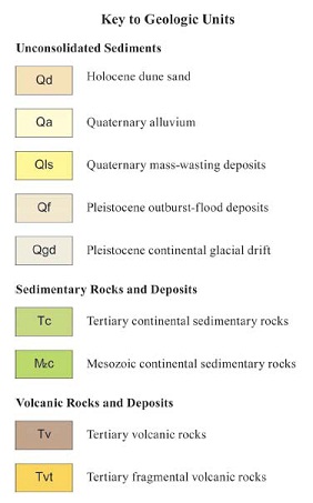
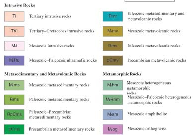
LEGEND FOR THE GEOLOGY OF WASHINGTON STATE
|
16
|
|
FIGURE 7. GEOLOGY OF THE BOSSBURG AREA
|
17
|
|
LEGEND FOR THE BOSSBURG GEOLOGY MAP
|
18
|
|
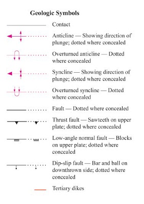
SYMBOLS FOR THE BOSSBURG GEOLOGICAL MAP
|
19
|
|
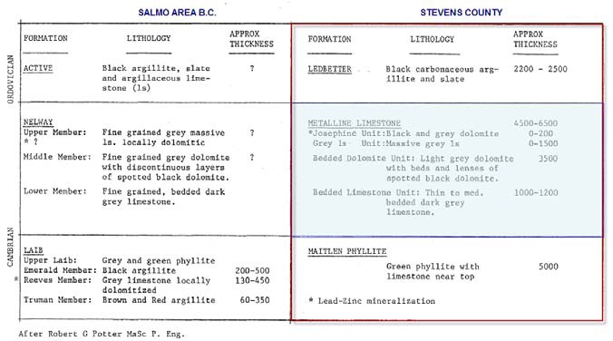
FIGURE 8. COMPARISON OF STRATIGRAPHY, BRITISH COLUMBIA AND NE WASHINGTON
|
20
|
|
MINERAL DEPOSITS
|
21
|
|
AG‐PB‐ZN MINES IN WASHINGTON
|
22
|
|
TABLE OF WASHINGTON AG‐PB‐ZN DEPOSITS
|
23
|
|
FIGURE 9 and 10. PLAN AND SECTION OF KOOTENAY ARC DEPOSITS
|
24
|
|
DEPOSITIONAL MODEL
|
25
|
|
Economic Characteristics
|
26
|
|
Grade and tonnage Characteristics
|
26
|
|
FIGURE 11. DEPOSITIONAL MODEL FOR METALINE DEPOSITS
|
27
|
|
ADJACENT PROPERTIES
|
28
|
|
Bonanza Mine
|
28
|
|
FIGURE 12. LOCATION AND TOPOGRAPHY OF THE BONANZA MINE
|
29
|
|
Metalline Contact Mines
|
33
|
|
SUMMARY AND CONCLUSIONS
|
34
|
|
RECOMMENDATIONS
|
34
|
|
SUGGESTED BUDGET
|
35
|
|
Phase I
|
35
|
|
Phase II
|
36
|
|
Phase III
|
36
|
|
REFERENCES
|
37
|
|
CERTIFICATE OF QUALIFIED PERSON BARRY J. PRICE, P. GEO
|
39
|
GEOLOGICAL SUMMARY REPORT
YOUNG AMERICA MINE
Bossburg, Stevens County, Washington State, USA
KINETIC RESOURCE CORP.
SUMMARY
The author has been retained to prepare a geological summary report for the Young America silver-lead-zinc deposit, situated near Bossburg, south of Northport in Stevens County, eastern Washington State. The author has not visited the property at this time, and has relied on brief reports by Wolff et. Al., and historical data by Hundhausen (1948)
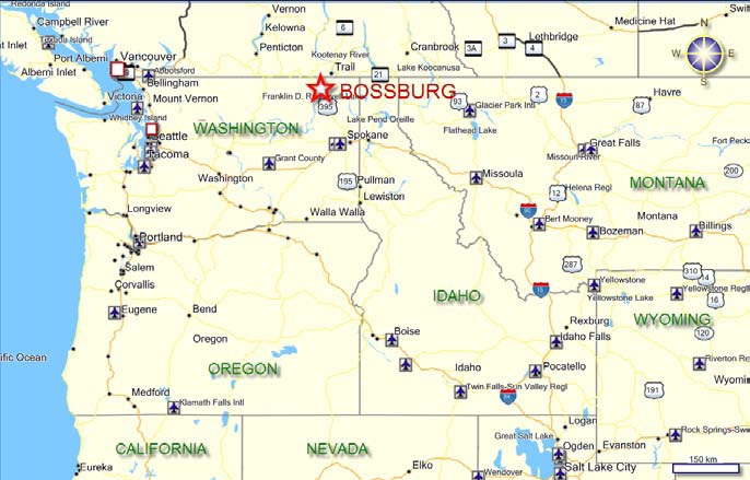
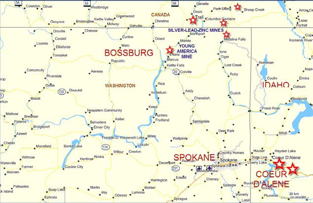
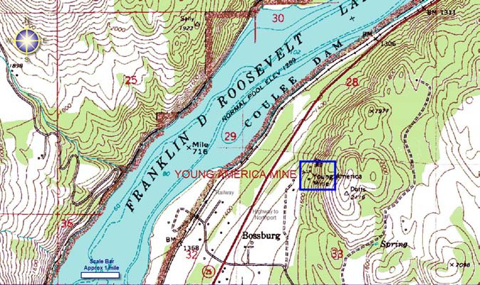
The property is situated about one mile north of the ghost town of Bossburg, on the Grand Coulee reservoir. Bossburg is situated about 15 miles north of Kettle Falls and about 20 miles south of Northport. The Young America mine is located in the SE¼SW¼ sec. 28, and NE¼NW¼ sec. 33, T38N R38E, about 2000 feet northeast of and 400 feet above the ghost town of Bossburg, Wash., a small settlement on the east bank of Lake Roosevelt (Figures 1-3)
The mine is located on BLM-managed land a quarter mile north of Bossburg, Wash., on SR 25. A two-wheel-drive gravel road, crossing private property, leads directly to the No. 1 adit. The mill ruins are located on private property below and adjacent to the west shoulder of SR 25 directly
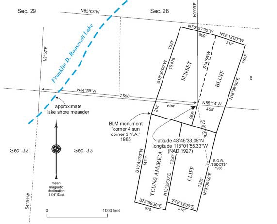
The property includes four non-patented claims, owned by American Mining Corp. Each claim is approximately 1500 feet by 600 feet. The author has not seen the claims; the new claims are reported to cover the old patented claims exactly. The original patented claims are shown in the accompanying Figure 4. The Young American claim group is at present four claims covering about 80 acres of lode claims 100% owned by American Mining Corporation, OF Osburn Idaho. The claims are on BLM managed land.
Amongst other lead-zinc silver showings and deposits such as the Bonanza and Old Dominion mines, the Young America property was discovered by prospectors in 1885, thus making it one of the first mines to produce lead, zinc, and silver in the Colville–Northport area. Production records prior to 1905 are unknown, but data assembled for the period 1905 through 1954 show cumulative production of 13,389 tons of raw ore containing approximately 940,000 pounds of lead, 771,000 pounds of zinc, 50 ounces of gold, and 70,000 ounces of silver (Fulkerson and Kingston, 1958). Wolff at al report that “All but 561 tons of reported production were mined in the years 1945 through 1954”.
The Young America silver-lead-zinc mine or deposit is one of numerous small to large past producing mines in north-eastern Washington state, on a regional structure which extends into Canada, where it is known as the Kootenay Arc. Origin of the deposits may be sedimentary exhalative (sedex) or Mississippi Valley type replacements in favourable limestone/dolomite host rocks.
The deposit, though small, had relatively high silver content. A small tonnage of mineralized material was outlined by past explorers; this has not been well defined.
The property is worthy of additional exploration efforts.
RECOMMENDATIONS
The following recommendations are made for the initial work on the property:
|
·
|
Obtain any mine plans and sections that may exist for the Young America mine
|
|
·
|
Visit the property and map in the workings
|
|
·
|
Determine the location of the drill holes
|
|
·
|
If the drill data is recovered, reconstruct several drill-sections
|
|
·
|
Sample the mineralized body where possible.
|
|
·
|
Consider staking additional claims
|
For the second phase, the following is recommended:
|
·
|
Determine if the mine workings are safe to enter, and if so, re-map the underground workings and re-sample where possible
|
|
·
|
Complete an Induced polarization (“IP”) survey and/or a gravity survey to determine if extensions of the mineralization may exist
|
Based on the above programs and contingent on the perceived success of the programs, undertake a drill program of diamond drilling. While the costs cannot be estimated exactly for this, an estimate is 1000 meters (approximately 3000 feet) at total, all-inclusive cost of $135,000.
Dated at Vancouver B.C. this 16th day of August, 2010
..........................................................................
Barry James Price, M.Sc., P. Geo., Consulting Geologist
GEOLOGICAL SUMMARY REPORT
YOUNG AMERICA MINE
Bossburg, Stevens County, Washington State, USA
KINETIC RESOURCE CORP.
INTRODUCTION
The author has been retained to prepare a geological summary report for the Young America silver-lead-zinc deposit, situated near Bossburg, south of Northport in Stevens County, eastern Washington State. The author has not visited the property at this time, and has relied on brief reports by Wolff et. Al., and historical data by Hundhausen (1948)
LOCATION AND ACCESS
The property is situated about one mile north of the ghost town of Bossburg, on the Grand Coulee reservoir. Bossburg is situated about 15 miles north of Kettle Falls and about 20 miles south of Northport. The Young America mine is located in the SE¼SW¼ sec. 28, and NE¼NW¼ sec. 33, T38N R38E, about 2000 feet northeast of and 400 feet above the ghost town of Bossburg, Wash., a small settlement on the east bank of Lake Roosevelt (Figures 1-3)
The mine is located on BLM-managed land a quarter mile north of Bossburg, Wash., on SR 25. A two-wheel-drive gravel road, crossing private property, leads directly to the No. 1 adit. The mill ruins are located on private property below and adjacent to the west shoulder of SR 25 directly west of the mine. Power and rail facilities are available. Supplies and services would be obtained from Northport or from Spokane.
CLAIMS
The property includes four non-patented claims, owned by American Mining Corp. Each claim is approximately 1500 feet by 600 feet. The author has not seen the claims; the new claims are reported to cover the old patented claims exactly. The original patented claims are shown in the accompanying Figure 4. The Young American claim group is at present four claims covering about 80 acres of lode claims 100% owned by American Mining Corporation, OF Osburn Idaho. The claims are on BLM managed land.
1
Kinetic Resources Corp. Option agreement
American Mining Corp. (AMC) has by a formal option agreement granted to Kinetic Resources Corp. (KRC) the sole and exclusive right and Option to acquire a one hundred percent (100 interest in the Young America claims , free and clear of all charges, encumbrances, claims, royalties and net profit interests, subject to the following option terms:
|
·
|
paying AMC four thousand dollars ($4,000) upon the execution of this agreement
|
|
·
|
paying AMC four thousand dollars ($4,000) on or before August 31, 2011
|
|
·
|
paying AMC twenty thousand dollars ($20,000) on or before August 31, 2012
|
|
·
|
paying AMC one hundred thousand dollars ($100,000) on or before August 31. 2013
|
|
·
|
incurring Exploration Expenditures on the Property as follows:
|
|
o
|
Exploration Expenditures of not less than fifteen thousand dollars ($15,000) on or before August 31, 2012;
|
|
o
|
aggregate Exploration Expenditures (including Exploration Expenditures as described in paragraph 4.3(e)(i) above) of not less fifty thousand dollars ($50,000) on or before August 31, 2013
|
|
o
|
aggregate Exploration Expenditures (including Exploration Expenditures as contemplated in paragraph 4.3e) (i) and (ii) above) of not less than one hundred and eighty six thousand dollars ($180,000) on or before August 31, 2014, and;
|
KRC is appointed the initial operator of the property and shall carry out exploration and development programs on the Property.
Claim Management
An annual $140 maintenance fee per claim is required to be filed or postmarked (if mailed) on or before September 1 of the year preceding an assessment year. If a claimant owns 10 or fewer active claims/sites on Federal land in the United States, he may qualify for a maintenance fee payment waiver.
2
FIGURE 1. LOCATION MAP OF NORTHWEST U.S.A.
3
FIGURE 2. NORTHEASTERN WASHINGTON STATE
4
FIGURE 3. TOPOGRAPHY OF BOSSBURG AREA
5
FIGURE 4. ORIGINAL PATENTED CLAIMS
6
FIGURE 5. GOOGLE EARTH IMAGE OF YOUNG AMERICA MINE
7
HISTORY
Bossburg
In 1888 silver was discovered in the hills above the northern part of the Columbia River. The Young America mine was established and drew miners and their families. Soon the mining company established a stamp mill and the steady increase in population prompted the development of a small town by the name of Millington. In 1892 the town was renamed to honour two of the town’s leading citizens: C. S. Boss and John Bergh. Chester S. Boss came west from Michigan after fighting in both the Civil and the Indian Wars. He was the first postmaster and storekeeper and was a member of the first school board. John Bergh was an influential pioneer and a clerk for the school board.
Bossburg was an active town. A cable ferry, known as the Young America Landing, shuttled prospectors and freight wagons, bound for mining fields in British Columbia, across the Columbia River. It is rumoured that traffic lined up waiting their turn to be taken across the wild Columbia. The ferry was not alone on the river, it was sometimes accompanied on the water with the unique "Kootnei canoes" of the Lake Native Americans. Bossburg was also known for its fruit, weekly newspaper, the durability of the area’s "flint clay" and of course the abundant sources of lumber.
Following construction of Grand Coulee Dam, the rising waters of the Columbia only took the west part of town.
After the mining era passed the population decreased rapidly. In 1956 the school district was dissolved and the students were sent down to Marcus and eventually to Kettle Falls. (Alpha Naff, The Last Bell) http://www.mapmet.com/Oldtowns/Bossburg.htm
Placer Gold Mining
South of Bossburg 5 miles in section 22 T37N R38E, is the Sandoz Placer, which was very productive. Between Bossburg and Marcus, on the east side of the Columbia River, in sections 16 and 21 T37N R38E, is the Valbush Bar Placers.
8
History of the Young America Mine
Amongst other lead-zinc silver showings and deposits such as the Bonanza and Old Dominion mines, the Young America property was discovered by prospectors in 1885, thus making it one of the first mines to produce lead, zinc, and silver in the Colville–Northport area. Production records prior to 1905 are unknown, but data assembled for the period 1905 through 1954 show cumulative production of 13,389 tons of raw ore containing approximately 940,000 pounds of lead, 771,000 pounds of zinc, 50 ounces of gold, and 70,000 ounces of silver (Fulkerson and Kingston, 1958). Wolff at al report that “All but 561 tons of reported production were mined in the years 1945 through 1954”.
1946-48
The U.S. Bureau of Mines (USBM)b conducted a diamond-drilling program on the cliff crest to the north, east, and south of the known ore body in the years 1946 through 1948 (Hundhausen, 1949). This report is an excellent description of the property and includes some geologic and metallurgical data from tests conducted at the Bureau’s (then) Albany, Oregon, research station. The program drilled 15 holes totalling 4590 feet. The drilling failed to find extensions of the high-grade sulphide mineralization previously mined, but did discover a low-grade body of highly disseminated lead-zinc mineralization.
Prospectivity is based on the drilling on the cliff crest to the north, east, and south of the main ore body. According to American Mining Corp. (brief summary 2010) the drilling discovered two zones of low-grade highly disseminated lead-zinc mineralization (sphalerite and galena) southwest of the mine, but failed to locate the primary sulphide mineralization of the main mine workings. Wolf et al. (2007) report that a general assessment of assay data from the cores shows consistent assays of ≤1% Pb, ≤1% ZN, ≤1 opt Ag, and a trace to .01 opt Au.
The USBM describes the mineralization as “bleached, silicified dolomitic limestone” called “dolomitic ore” in the report. The general dimensions of the two mineralized areas begins about 80 feet below the surface and ranges from 30 to 150 feet thick, trends N 30 degrees East, and dips gently to the southeast. Areal extent is about 900 feet from northeast to southwest and 200 feet east to west.
In 2009, an option was held on the claims by Stevens Resources Inc. of Spokane Washington, but the option was not maintained.
9
A private report from Kennecott Exploration (1990) reviewed by AMC suggests that the USBM drilling outlined roughly 100,000 to 150,000 tons of the low-grade stratiform dolomitic ore in two zones of consistent thickness and grades. Kennecott further reported that mapping in about 1990 showed a major fault about ¾ of a mile to northeast of the USBM drill sites, suggesting that if the low grade zones continue to the fault, 2-3 million tons of mineralized material could be present, with grades of roughly average 1.0% Pb, 3.0% Zn, and 2.0 opt Ag. The present author has no way of independently verifying the above information and it should be used with caution.
Production
No production records exist prior to 1905. Production from 1905 to 1954 show cumulative production of 13,389 tons of ore containing about 940,000 pounds of lead, 771,000 pounds of zinc, 50 ounces of gold, and 70,000 ounces of silver. All but 561 tons of production was mined between 1945 and 1954.
|
Lead
|
Zinc
|
Gold
|
Silver
|
|
|
13389 tons
|
940,000 lbs
|
771,000 lbs.
|
50 ounces
|
70,000
|
|
Recovered grade*
|
3.50%
|
2.88%
|
0.0037 opt
|
5.23 opt
|
| * Head grades would have been higher, but percentage recoveries are unknown | ||||
Historical mining focused on two relatively flat-lying mineralized zones parallel to each other but separated by about 30 feet elevation. The two zones crossed bedding planes and were mined up-dip about 60 feet elevation to a point 240 feet distant from adits in the cliff face. At that point a calcite rich shear zone with a few feet of offset cuts the main mineralization, which continues on the downthrown side of the shear zone. The mineralized lenses range from a few inches to 6 feet thick and are an intimate mixture of sphalerite, argentiferous galena, and pyrargyrite. Gangue minerals are pyrite, quartz, calcite, and siderite. Minor amounts of tin were present.
Wolf et al. (2007) reports that a 350 pound sample taken by the USBM from the cliff stope is probably typical of the main sulphide vein material.
10
|
Zn
|
Pb
|
Cu
|
Fe
|
Sb
|
Ag
|
Au.
|
|
10.9%
|
5.9%
|
0.09%
|
1.2%
|
0.07%
|
10.6 opt
|
.011 opt
|
Ownership/Land Status
The Young American property is 4 adjoining unpatented claims originally located in 1886. In 2008 American Mining Corporation of Osburn, Idaho has staked the four original unpatented claims that are located on BLM managed land. The four claims are approximately SW¼ Section 28, and NW¼ Section 33, both T38N R38E, Stevens County, Washington about 15 miles north of Kettle Falls, Washington.
At present, the claims are beneficially owned by American Mining Corp. of Idaho. Fees are payable every September 1 to maintain the claims.
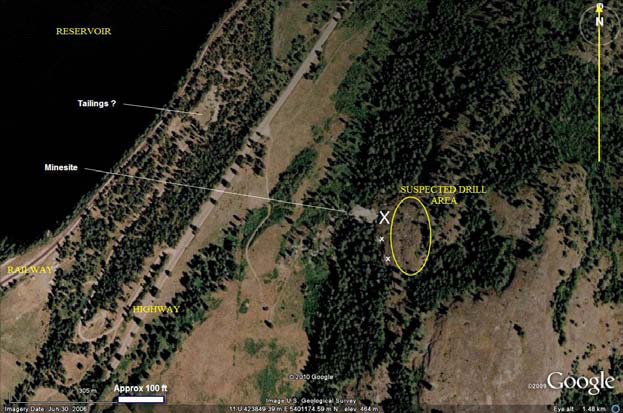
Mine Workings
Most production took place in the four adjacent adits highest on the cliff face. The opening shown in Figure 5 is probably the No. 2 level identified as the main haulage way by Hundhausen (1949). The other three 8 by 10 foot adits are about 20 feet apart and strike east into a onjoined room-and-pillar stope rising up-dip 12 degrees. The room is approximately 50 feet wide, 60 feet long, and 6 feet high.
Wolff reports an extremely hazardous open stope terminating in a steeply inclined unfenced winze. This feature is located on a forested slope near the No. 5 tunnel portal, approximately 120 feet below the cliff adits (Wolff’s Figs. 6 and 7).
About 30 feet below and 100 feet north of the No. 2 level, an 8 by 10 foot opening has been driven east into the limestone and curves around to the southeast beneath the cliff adits. The location of this opening coincides with the No. 4 level, and the band of disseminated sulfide minerals shown in Figure 3 is the near surface extension of the “lower vein outcrop”
The assay office and a cabin were still standing in September 2003. A raw-ore storage bunker is located at the foot of the primary waste rock dump. The aerial tram cable and anchoring
turnbuckles are still in place (Fig. 8). The mill, described below, is in ruins.
Some of the historical ownership is detailed in table form on the following page.
11
|
Company
|
Registered in Washington?
|
Date registered with Sec. of State
|
Date stricken or dissolved
|
Comment
|
Place of business
|
|
Young America Consolidated Mining Co.*
|
yes
|
Jan. 1886
|
1923, for non-payment of fees
|
shipped hand-sorted ore until 1897 prox.
|
Spokane Falls, Wash.
|
|
Young America and Cliff Consolidated Mining Co.*
|
yes
|
1897
|
1909, for non-payment of fees
|
mined 1897–1905
|
Spokane, Wash.
|
|
Robena Lead Co.
|
no
|
N/A
|
N/A
|
1907–1915
|
unknown
|
|
Cuprite Mining Co.*
|
yes
|
1916
|
voluntary dissolution, 1948
|
1916–1948
|
Yakima, Wash.
|
|
Gregor Mines, Inc.*
|
yes
|
1941
|
1958
|
1948–1950
|
Seattle, Wash.
|
|
Leila Archibald, Frank Riggle, Perry Leighton, W. C. Morris
|
no
|
N/A
|
N/A
|
exploration activities, possessory title only; lease to Young America Mines, Inc., 1950
|
Bossburg, Wash.
|
|
Young America Mines, Inc.*
|
yes
|
1950
|
1957
|
operated in 1950 and 1951
|
Seattle, Wash.
|
|
Earl Gibbs and Ira Hunley, dba Bonanza Lead Co.*
|
yes
|
1957
|
1961
|
operated 1951–1954
|
Colville, Wash.
|
|
Silver Hill Mines, Inc.*
|
yes
|
March 1961
|
inactive; license expired March 2006
|
1990–1992 exploration activities, possessory title only; UBI #601333876
|
Spokane, Wash.
|
|
Conjecture Silver
|
no
|
N/A
|
N/A
|
1997 exploration activities, possessory title only
|
unknown
|
12
HISTORICAL CLAIM OWNERSHIP
GEOLOGY
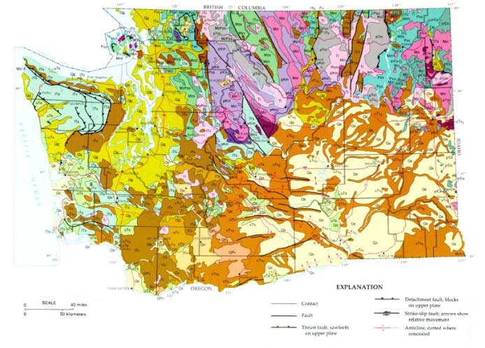
Regional Geology
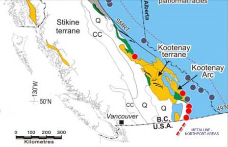
The Northport area is the southern extension of a structural feature known across the Canadian border as the Kootenay Arc, a folded and faulted assemblage of Paleozoic sedimentary rocks which contains numerous large and small deposits of silver-lead and zinc, many of which have achieved production. The Kootenay Arc type deposits are discussed in more detail under Mineral Deposits.
Local Geology
The following account is reproduced from Wolff et. Al (2008) Washington Division of Mines Information Circular 105.
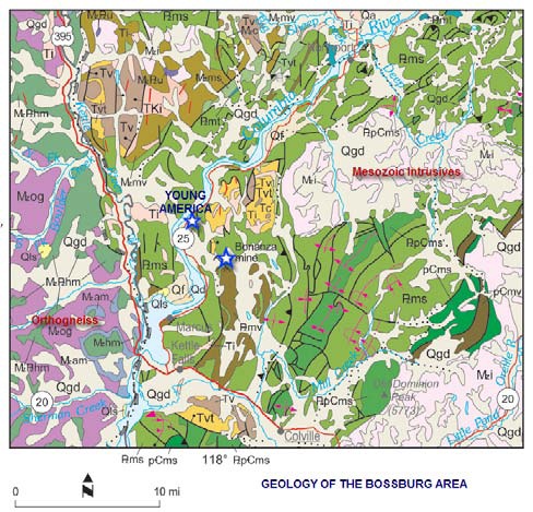
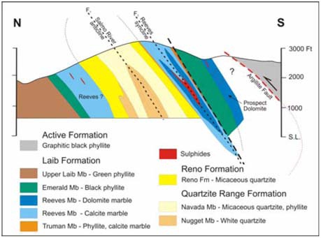
All development at the Young America mine was in the lower unit of the Middle Cambrian Metaline Limestone, a dense, fine-grained, bluish-gray dolomitic limestone that strikes N20°E and dips 12–20°E.
In the immediate vicinity of the mine, the host rock is highly brecciated and silicified. Production came from two relatively flat-lying mineralized zones parallel to each other but separated by about 30 feet in elevation. These two zones transgressed bedding planes and have been mined up-dip about 60 feet in elevation to a point 240 feet distant from adits in the cliff face where a post-ore, calcite-rich shear zone was encountered. It dips 72°SE, but the reported displacement is relatively small—“in most places the east side is down only a few feet”—and ore continued on the down-thrown east side of the shear (Hundhausen, 1949).
(Note that the material above is reproduced from IC 105, and the term “ore” is used only in a mineralogical sense and would not now be classified as ore.
The ore lenses range in thickness from a few inches to 6 feet. Primary sulphide minerals consist of an intimate mixture of sphalerite, argentiferous galena, and pyrargyrite. In addition, the upper ore horizon carried a significant concentration of geocronite, a lead–antimony mineral. In metallurgical tests conducted by USBM, the galena and sphalerite fractions were found to range in size from minus 48 to plus 560 mesh (Hundhausen, 1949). Some tetrahedrite and chalcopyrite inclusions appeared in the galena. Bunning (1985) reported that a sample of primary sulphides from the upper mineralized zone contained 1000 ppm tin, probably from the mineral stannite. She also identified the presence of stibiconite, a hydrated antimony oxide. In addition to identifying stibiconite var. schulzite, Purdy (1951) identified microscopic inclusions of cobaltite in euhedral grains of pyrite. The carbonates of lead and zinc, cerussite and smithsonite, were mined from a narrow high-grade zone of oxidation prior to 1905. Although hand-picked specimens are reported in anecdotal accounts as containing bonanza-type assays of lead, zinc, and silver, a 350-pound sample taken by the USBM from the cliff stope is probably the best representation of the kinds of values contained in the sulphide vein material: Wolf et al. (2007) reports that a 350 pound sample taken by the USBM from the cliff stope is probably typical of the main sulphide vein material.
13
|
Zn
|
Pb
|
Cu
|
Fe
|
Sb
|
Ag
|
Au.
|
|
10.9%
|
5.9%
|
0.09%
|
1.2%
|
0.07%
|
10.6 opt
|
.011 opt
|
The gangue minerals are pyrite, quartz, calcite, and siderite. A feature discovered in 1920 appears to be a pre-ore void filled with post-ore erosional or glacial deposited materials. Patty (1921) reported that a 40-foot inclined shaft sunk at the north end of the No. 4 level stope encountered “. . . ore for the first 20 feet in the shaft, then gravel carrying occasional boulders of ore, and after sinking through 10 feet of gravel the shaft was abandoned”.
The primary mineralization shows some characteristics of a replacement-type deposit and some characteristics of open-space filling as indicated by observations made by different investigators. It is possible that both processes have taken place at separate times on one or more occasions. On the basis of thin-section studies, Purdy (1951) postulated eight different stages of mineralization at the Young America, beginning with pre-ore fracturing, followed by deposition of sulphides, quartz, calcite, and siderite in different episodes, and ending with post-mineral movement on the calcite-rich shear zone described above.
Hundhausen concluded that the “ . . . ore shoots in the mine consist of replacement stringers, veins and lenses along an irregular, gently dipping zone of movement. The ore is not confined within sharply defined walls. In some places the zone consists of a series of narrow bands of ore separated by unreplaced limestone”. We observed sharp boundaries above and below the few exposures of sulphides left in place, which lends credence to the role played by open space filling (Fig. 3). Numerous flexures within the mine, faults both normal and reverse, and a tightly folded syncline on a cliff immediately south of the cliff adits indicate that the area has been the scene of significant tectonic activity in the past. Bunning (1985) examined a piece of dump rock consisting of brecciated limestone clasts cemented with quartz. “The quartz, deposited concentrically around each fragment, suggests passive, open-space filling. The passive breccia filling, sharp contacts of ore with the wall rocks, and variable thickness and pitch of the ore zone, all indicate the ore was deposited in an open zone—most likely a fault—in the otherwise unaltered limestone.”
The Hundhausen report (Bureau of Mines) apparently has mine drawings which should be obtained.
14
FIGURE 6 . GENERALIZED GEOLOGY OF WASHINGTON STATE
15
LEGEND FOR THE GEOLOGY OF WASHINGTON STATE
16
FIGURE 7. GEOLOGY OF THE BOSSBURG AREA
17
LEGEND FOR THE BOSSBURG GEOLOGY MAP
 |
 |
18
SYMBOLS FOR THE BOSSBURG GEOLOGICAL MAP
19
FIGURE 8. COMPARISON OF STRATIGRAPHY, BRITISH COLUMBIA AND NE WASHINGTON
20
MINERAL DEPOSITS
The following discussion of Kootenay Arc mineral deposits is taken from Simandl and Paradis (2009)
The Kootenay Arc contains numerous carbonate-hosted Zn-Pb deposits (Fig. 1), including several past-producers (e.g., Reeves MacDonald, Jersey-Emerald, HB, Mastodon) and a number of advanced exploration projects (e.g., Oxide, Jackpot, Duncan, Abbott, Wigwam). The largest deposits range in size from 6 to 10 Million (M) t and contained on average 3-4% Zn, 1-2% Pb, 0.4% Cd, and traces of Ag. The deposits are hosted by deformed and metamorphosed Lower Cambrian platformal carbonates of the Badshot Formation, or its equivalent, the Reeves member of the Laib Formation.
Note that the numerous Ag-Pb-Zn deposits in the Metaline and Northport areas of NE Washington are on the southern extension of the “Kootenay Arc”.
The present distribution and form of the deposits are controlled by the regional structure. They are essentially stratabound, lenticular concentrations of sulphides (sphalerite, galena, pyrite, local pyrrhotite and rare arsenopyrite) confined to dolomitic and/or siliceous zones, which are folded isoclinally (Fig. 2). These structures mimic the large-scale regional structures, and are commonly elongated parallel to the regional structural grain. As well, the sulphides and their dolomitic envelopes have been affected by regional and local contact metamorphism. Field and microscopic observations indicate that the sulphides appear to have formed primarily by replacement of the host carbonates, with minor open space filling of breccia zones, fractures and vugs.
The near-surface portions of several carbonate-hosted sulphide deposits are weathered, strongly oxidized, and consist of extensive Zn- and Pb-bearing iron oxide gossans and base metal-bearing nonsulphide mineralization (Fig. 3). The Reeves MacDonald, Jersey-Emerald, HB, Lomond, and Oxide group of deposits exhibit the best examples of carbonate-hosted nonsulphide base metal mineralization in the southern Kootenay Arc. Sulphide oxidation post-dates Middle Jurassic deformation (i.e., age of regional metamorphism and first phase of deformation) and may have started before or slightly after the last glacial maximum (17 000–14 000 BP). The relatively warm and dry climate, which prevailed some 10 000–7000 BP, may have been particularly favourable for supergene oxidation of sulphides and formation of carbonate-hosted nonsulphide base metal mineralization in the southern Kootenay Arc (Simandl and Paradis, 2009). However, the recent documentation of nonsulphide Pb-Zn mineralization north of the study area (Paradis et al., 2010) suggests that, under favorable geological conditions, this type of mineralization should be expected in the northern portion of the Kootenay Arc as well.
The origin of the sulphide deposits of the Kootenay Arc is enigmatic because of the intense deformation that has modified most of their original features. However, Re/Os isotope analyses on the Reeves MacDonald sulphides indicate that the mineralization occurred during the Devonian period and that the deposits are epigenetic [i.e., Mississippi Valley-type (MVT)]. They share many characteristics with other Cordilleran MVT deposits including: (1) they are hosted by altered dolomitized and/or silicified carbonates; (2) the deposits contain simple mineral assemblage of pyrite, sphalerite, and galena; (3) the mineralization is zinc-rich (high sphalerite/galena ratios: Zn:Pb from 10:1 to 2:1); (4) they display complex ore textures and alteration assemblages; (5) pyrite, sphalerite, and galena grains have isotopically heavy sulfur (δ34S values = 9.0 to 26.4 per mil); and (6) galena and sphalerite have radiogenic Pb.
21
The new Devonian age confirms the epigenetic nature (as opposed to syngenetic) of the sulphide deposits, and improves our understanding of the genesis of these deposits in the context of the Cordilleran tectonics. The Devonian was an important metallogenic epoch that saw the proliferation of base metal deposits along the continental margin of North America with coeval development of volcanic-hosted massive sulphide (VHMS) deposits in arcs and back-arcs of the pericratonic terranes, sedimentary exhalative (SEDEX) deposits in continent-margin basins, and finally MVT deposits in continental platforms. From the prospecting point of view, determination of the physical properties of the sulphide and nonsulphide mineralization and their host rocks in the Kootenay Arc is one of the essential steps that will lead to improved interpretation of existing and future geophysical surveys. The use of portable XRF in exploration for white Zn-rich nonsulphide deposits appears as one of very promising and potentially cost-effective exploration tools.
AG-PB-ZN MINES IN WASHINGTON
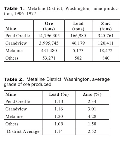
Production for the Metaline district from 1906 to 1977 is given in the following tables. The Pend Oreille mine was by far the largest producer. The average grade of the 19.3 million tons of ore mined in the district was 1.14 percent lead and 2.25 percent zinc. Annual Pend Oreille mine production is given in Table 3. Increased production rates beginning in 1938 reflect the needs of WWII and the Korean and Viet Nam conflicts.
By-products were copper, silver, cadmium, and traces of gold. Silver is carried in the galena concentrate (2.3 oz per ton), and the sphalerite concentrate assays 0.2 percent cadmium. Copper, in the form of chalcopyrite and tetrahedrite, seems to report with the sphalerite concentrate. Geochemical analyses of pyrite concentrate indicate the presence of minor amounts of tennantite (Bending, 1983).
http://www.dnr.wa.gov/Publications/ger_washington_geology_1995_v23_no1.pdf
22
TABLE OF WASHINGTON AG-PB-ZN DEPOSITS
23
FIGURE 9 and 10. PLAN AND SECTION OF KOOTENAY ARC DEPOSITS
24
DEPOSITIONAL MODEL
(From: http://cgc.rncan.gc.ca/mindep/synth_dep/sedex/index_e.php#fig11)
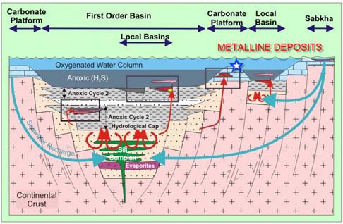
The Kootenay arc Ag-Pb-Zn deposits are variously classified as sedimentary exhalative (SEDEX) deposits or a variant of the replacement deposits or Mississippi Valley type deposits (MVT).
Sedimentary exhalative (SEDEX) deposits are typically tabular bodies composed predominantly of Zn, Pb, and Ag bound in sphalerite and galena that occur interbedded with iron sulphides and basinal sedimentary rocks, and that were deposited on the seafloor and in associated sub-seafloor vent complexes from hydrothermal fluids vented into mostly reduced sedimentary basins in continental rifts.
Subtypes of SEDEX deposits include:
|
·
|
the Broken Hill type (BHT) and those that formed below but near the seafloor (e.g., Irish-type deposits). BHT deposits (Beeson, 1991; Parr and Plimer, 1993; Walters, 1998) are characterized by high metamorphic grade, elevated base metal to S ratios, a spatial and temporal association with Fe-Si-Mn oxide exhalites, and bimodal felsic-mafic volcanic/intrusive and fine- to coarse-grained, mostly clastic sedimentary host rocks.
|
|
·
|
The Irish type of SEDEX deposits (e.g., Hitzman and Beaty, 1997) is hosted predominantly by carbonate rocks and these deposits, either individually or collectively (district-wide), may show characteristics of both seafloor deposition and epigenetic features typical of Mississippi Valley-type (MVT) deposits (e.g., Sangster, 1990; Paradis et al., 2007). Irish-type deposits are considered to have formed by mineralization-forming processes similar to those of SEDEX deposits, but because carbonate platforms are highly soluble in mildly acidic mineralization fluids, the mineralizations were also deposited in open space that commonly formed by hydrothermal karsting (e.g., dissolution voids, collapse breccias).
|
It is generally recognized that, especially at the deposit scale, no matter the criteria used to define a SEDEX deposit, there is a continuum of characteristics between SEDEX and VMS (volcanogenic massive sulphide) deposits on the one hand, and SEDEX and MVT deposits on the other hand. The distinction between the three classes of deposits is based not only on the typical physical, chemical, and geological attributes of member deposits and their respective geological environments, but also on genetic models for the class. Both SEDEX and MVT deposits occur within marine platforms of thick sedimentary basins and are thought to result from the migration of basinal metalliferous saline fluids, whereas VMS deposits occur in submarine volcanic-sedimentary sequences and are formed from convective hydrothermal fluids driven by, and/or magmatic fluids from, a subvolcanic magma body. Both SEDEX and VMS deposits were formed by hydrothermal systems that vented fluids onto the sea floor, so that the age difference between the mineralizations and the immediate host rocks is by definition small. In contrast, MVT deposits formed in the subsurface and so the age difference between mineralizations and host rocks can be much larger than for SEDEX deposits (Leach et al., 2001; Leach et al., 2005).
25
SEDEX-associated deposits include MVT (Paradis et al., 2007) and stratiform barite deposits (Goodfellow, 2004). The MVT deposits occur in platformal carbonate sequences that are the shallow-water facies equivalent of basinal, typically fine-grained sediments that host SEDEX deposits. Although there is debate regarding the genetic link between SEDEX and MVT deposits, the overlap in timing and the compositional similarities suggests that these deposits formed from similar basinal metalliferous fluids (Goodfellow, 1987; Sangster, 1990). The only major difference is that mineralization-forming fluids vented at the seafloor in the case of SEDEX deposits whereas most of the sulphide precipitation took place subsurface in the case of MVT deposits. The source of most of the reduced S in both deposit types is most likely bacterial reduced seawater sulphate (Goodfellow, 1987).
Economic Characteristics
SEDEX deposits are an important resource for Zn and Pb (Table 1). In 2004, SEDEX deposits accounted for 38.8% and 65.1% of the western world’s Zn reserves and resources, respectively (Fig. 1; Hunt, 2006). By comparison, VMS and MVT deposits accounted for 30.2% and 15.3%, and 4.2% and 1.4%, of Zn reserves and resources, respectively. In addition, the percentage of SEDEX Zn reserves has shown a consistent increase over the past two decades. In 2004, SEDEX deposits also accounted for 32% of Zn production that was followed by VMS at 27%, Zn oxide at 12%, and MVT at 6%. The size (in tonnes of Pb + Zn metal) of SEDEX deposits is on average about an order of magnitude greater than that of VMS deposits (Goodfellow et al., 1993).
Grade and tonnage Characteristics
There are 132 SEDEX including Irish and BHT deposits world wide with grade and tonnage figures (Fig,. 2 and Appendix 2, DVD), and of these, 50 have geological resources greater than 20 Mt (Table 1). In Canada, there are 35 deposits with known geological resources (Appendix 1, DVD), of which seven contain mineralization than 20 Mt, including the Sullivan deposit with 161 Mt and the Howards Pass deposits estimated at 120 Mt (Table 2 and Fig. 2). Of the 35 Canadian deposits, 12 are past producers, the largest of which is the Sullivan deposit that produced 149 Mt of 5.33% Zn and 5.64% Pb (Table 3). The Howards Pass deposit is currently not economic, although it is currently undergoing major exploration and evaluation. Most SEDEX deposits in Canada occur in the Anvil, MacMillan Pass, and Howards Pass districts, Selwyn Basin; the Gataga district, Kechika Trough; the Sullivan district, Belt-Purcell; and the Duncan district, southern British Columbia.
26
FIGURE 11. DEPOSITIONAL MODEL FOR METALINE DEPOSITS
27
ADJACENT PROPERTIES
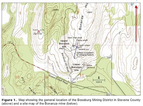
Kinetic has no ownership of the deposit described below, but the information is provided as the Bonanza deposit is similar in many ways to the Young America deposit. This information is provided solely for background.
Bonanza Mine
Bonanza mine Stevens secs. 2 and 11, T37N R38E 48.72886 117.98980 Echo Valley Colville
The Bonanza lead mine (Fig. 1) is located one-half mile north of the Evans Cutoff Road in Stevens County, in secs. 2 and 11, T37N R38E. Outcrops of galena were discovered at the property in 1885. Approximately 102,000 tons of ore were mined from 1907, the first year production records are available, through closure in 1953. Most of this total took place during the 11 years prior to closure by a partnership of Earl Gibbs and Ira Hunley doing business as Bonanza Lead Co. Total production of lead from all owners and leasers is 24.9 million pounds, accounting for one-fifth of all lead produced in Stevens County until 1980. The overall grade was 12.2 percent lead. Additional silver, copper, and zinc recoveries are shown below under Mine Operations Data. The Bonanza Mill is located 2 miles north of Colville on State Route (SR) 395 in sec. 31, T36N R39E.
The mine was developed on seven levels by two inclined shafts at the upper Bonanza site and a crosscutting adit entering the 6 level from the center of sec. 11 at the lower Bonanza site. Total development exceeds 9600 feet. High-grade masses of galena intermixed with pyrite occur in discontinuous lenses at or near the contact of two metasediments: phyllite overlain by argillite. The ore horizon was generally 4 to 6 feet thick on the east and west limbs and crest of a gently plunging anticline and as much as 27 feet thick at a fold hinge. Various investigators have attributed the ore deposit’s genesis to two different models: (a) vein formation of hydrothermal origin in a shear zone, and (b) mineralization co-deposited at the same time as the sediments, that is, a stratiform, syngenetic deposit. Both models indicate the effect of low grade metamorphism on the sulphides. The Anaconda Copper Mining Co., Inc., held a lease/purchase option on the mine in 1951 and 1952, as did the Bunker Hill Co., Inc., in 1961. Both major companies conducted significant, but unsuccessful, exploration programs in an effort to locate extensions of the Bonanza mineralization. The former mine lands have been subdivided and are now held by private parties. The mine is collapsed internally and caved to the surface in places.
The mine was developed on seven levels by two inclined shafts at the upper Bonanza site and a crosscutting adit entering the 6 level from the center of sec. 11 at the lower Bonanza site. Total development exceeds 9600 feet. High-grade masses of galena intermixed with pyrite occur in discontinuous lenses at or near the contact of two metasediments: phyllite overlain by argillite. The ore horizon was generally 4 to 6 feet thick on the east and west limbs and crest of a gently plunging anticline and as much as 27 feet thick at a fold hinge. Various investigators have attributed the ore deposit’s genesis to two different models: (a) vein formation of Hydrothermal origin in a shear zone, and (b) mineralization co-deposited at the same time as the sediments, that is, a stratiform, syngenetic deposit. Both models indicate the effect of low grade metamorphism on the sulphides.
28
FIGURE 12. LOCATION AND TOPOGRAPHY OF THE BONANZA MINE
29
Jenkins (1924) described the Bonanza ore body as “boldly outcropping on the surface” at the time of its discovery in 1885. A linear cut approximately 1000 feet long by 25 feet wide and an open pit east of the present upper Bonanza site indicates that pre-1907 production came from these mineralized surface exposures (Fig. 1).
Fulkerson and Kingston (1958) reported that Deer Trail Consolidated Mining Co., Ltd., took possession of the mine in 1907 and continued production through 1920. During this period, 7200 tons of hand-sorted ore averaged 18 percent lead. Deer Trail sank a 30-degree inclined shaft and opened up stopes on four levels, separated by approximately 50 feet in elevation. G. J. Vervaeke, a former leaser at the mine, purchased title in 1923 and built a small gravity concentrator near the shaft using jigs and tables (Puffett and Anderson, 1954). Vervaeke made the last extension of the inclined shaft from the 4 level to the 7 level.
In total, the shaft has a slope distance of 580 feet and bottoms out 340 feet below the surface (DGER mine map file).
Bonanza Mining and Milling Co. Inc. operated the mine in 1929 and built a flotation mill at the site that burned down the following year. Northern Lead Mining Co., Inc., operated the mine in 1931 and 1932. Whether these two companies had title to the property or not is unknown. There is a break in the production record until 1942 when a lease was undertaken by Russell Parker, owner and superintendent of the First Thought gold mine near Orient. Mr. Parker received a $5000 mine development loan from the Reconstruction Finance Corporation. This money was used to reopen the discovery shaft located 80 feet east of the Deer Trail production shaft. Referred to as the ‘Parker Shaft’, it accessed old workings on the 1 level and 2 level (DGER mine map file). From 1942 through 1943, Parker produced 356 tons of ore grading 25 percent lead and built a rudimentary gravity mill near the shaft (Fulkerson and Kingston,
1958).
In January 1945, Dr. Ira M. Hunley, Spokane, purchased the mine from the Vervaeke estate. Hunley formed the Bonanza Lead co-partnership in 1946 with Earl Gibbs, a Colville miner. In addition to expanding the mine’s development, Gibbs and Hunley built a 100 ton per day (tpd) selective flotation mill at Palmer Siding, 2 miles north of Colville on SR 395.
Bonanza Lead partnership drove over 3100 feet of drifts, stopes, and raises, including the 2000-foot Gibbs Crosscut shown in Figure 1. This adit intersected the eastern limb of the mineralized anticline described below, thus obviating the necessity of reconditioning the inclined shaft and provided a means of draining the mine. Production from 1946 through early 1951 was 73,535 tons of ore containing 18.3 million pounds of lead and 163 thousand ounces of silver. During this period, improved selective separations in the mill also recovered 92,600 pounds of zinc and 16,000 pounds of copper.
Bonanza Lead operated the mine until Feb. 9, 1951, at which time the Anaconda Copper Mining Co., Inc., acquired a lease/ purchase option from Gibbs and Hunley that included a $500,000 down payment on a $2 million total purchase price; the balance to be paid via 12 percent net smelter returns. The mine was then producing about 100 tpd with 65 combined mine and mill employees (Puffett and Anderson, 1954). Anaconda engineers mapped all the accessible underground development (DGER mine map file). “Anaconda continued operations and undertook an extensive diamond drilling program to locate additional ore, but the program was reported to be unsuccessful”
30
(Wallace Miner, March 12, 1953). Anaconda terminated the option agreement in March 1953 after recovering 10,580 tons of ore-grade waste rock (Fulkerson and Kingston, 1958).
In June 1954, Bonanza Lead applied for a Defence Minerals Explorations Administration (DMEA) loan to find a possible oreshoot thought to extend downward [from the 7 level to a proposed 9 level]. Based on a comprehensive review of Anaconda’s unfavourable drilling results, an underground examination, and detailed cross sections, the request was denied (Puffett and Anderson, 1954).
Gibbs and Hunley operated the Young America mine in 1952 and 1953 under the Bonanza Lead co-partnership (Wolff and others, 2007). In October 1957, Gibbs formed a corporate entity, Bonanza Lead, Inc., which dissolved in July 1961.
The Bunker Hill Co., Inc., entered into a lease/purchase option agreement with the estate of E. Gibbs in 1961 for the purpose of exploring the Bonanza lode claim and 1800 acres of land owned in fee simple in secs. 1, 2, 3, 10, 11, and 12, T37N R38E.
Bunker Hill reportedly conducted geochemical soil surveys in conjunction with some diamond drilling in 1962 (Wallace Miner, Oct. 19, 1962). The results are not available, but it appears the exploration was unable to locate additional ore reserves, and the mineral rights and property involved were surrendered to successors of the Gibbs estate in 1979 for the purpose of clearing title (Stevens Co. Assessor’s Office, written commun., 2007).
No mining has taken place since the 1953 close of operations, when all the pipe and track were pulled from the underground workings (Puffett and Anderson, 1954). Nothing remains of the surface plant except Bonanza Lead’s circa-1946 concrete block compressor house and shop at the lower adit. As discussed below, the mine has collapsed.
31
Geology at the Bonanza mine is similar to that at Young America. Host rocks at the site are metasediments characterized as “mid-Paleozoic basinal rocks which range in age from Ordovician to uncertain Devonian age, informally subdivided into ten stratigraphic units. These units contain interbedded argillite, phyllite, some greywacke, chert, limestone, and greenstone and have undergone at least two major fold deformations, one or mineralization minor deformations, and major north-trending high-angle faulting—tectonic events having a significant effect on the structural geology of the mine and the location and richness of the mineralization. Two distinct units are exposed in the mine workings: light green chloritic phyllite overlain by black carbonaceous argillite locally rich in calcite
The sediments are part of a gently north-plunging anticline with locally intense folding and faulting. In the mine workings west of the shaft, the mineralization and sediments strike roughly northeast and dip 30 to 55°W; in the central part of the mine, the strike is east–west with dips 10 to 35°N. In the easternmost mine workings, approximately 400 feet from the shaft, the mineralization horizon strikes roughly north and dips 25 to 55°E (Mills, 1985). Alluvial sand and gravel several hundred feet thick overlie the downward dipping sediments on both limbs of the anticline.
The mineralization is found in discontinuous lenses conformable with the argillite-phyllite contact and in veins within the underlying green phyllite. The primary mineralization is fine-grained ‘steel’ galena that occurs in masses intimately mixed with approximately equal pyrite content. Recovery of zinc and copper is attributed to minor amounts of sphalerite and chalcopyrite respectively. Scanning electron microscopy shows small inclusions of silver-bearing tetrahedrite and pyrargyrite. In one area at a fold hinge, mineralization 27 feet thick was mined.
The gangue minerals are milky quartz, siderite above the 4 level, fragments of foliated host rock, and barite. Disseminated pyrrhotite and magnetite are also present. The Bonanza mineralization has been ascribed to two different models:
|
·
|
vein(s) formed by hydrothermal replacement of rocks in a shear zone, and
|
|
·
|
sulfides deposited in a stratiform syngenetic environment in which the mineralization was formed contemporaneously with the enclosing rocks.
|
Above the contact the argillite has been distorted and carbonized for a thickness in excess of 50 feet, but the foliation in the phyllite beneath the contact shows little distortion. It is believed the distortion in the argillite has resulted from thrust faulting of the argillite over the phyllite and that the contact is a fault contact. The upper 20 to 50 feet of the phyllite has been strongly bleached to a light, creamy color, probably the result of hydrothermal solutions” (Puffett and Anderson, 1954). Bancroft and Lindgren (1914) observed fault gouge up to 3 feet thick surrounding mineralization in the contact between the two host rocks.
32
One or more aplite dikes are closely associated with sulfides in the mine, and Jenkins (1924) reported them to be “mineralized with quartz stringers grading into mineralization”. However, two separate studies of the Bonanza mineralization in the 1980s revealed the presence of primary textures suggestive of a sediment-hosted stratiform deposit: Mills (1985) found “interbedded sulfides and rock-forming silicates, nodular, colloform and framboidal textures, and atoll textures in pyrite, sphalerite, and galena...compatible with or diagnostic of sedimentary mineralization formation.” Jackson (1984) states that, “Colloform textures, and framboids [raspberry-shaped clusters of pyrite grains, linked with the presence of organic materials] are undoubtedly primary textures. These features are found at most sediment-hosted stratiform deposits where they are interpreted to be of syn-sedimentary origin.” Annealing, flowage, and rounding mineralization in the contact between the two host rocks.
Twinning in galena and sphalerite found in these studies suggest the mineralization body has been subjected to several episodes of post-mineral metamorphism and temperatures of 300 to 500°C.
Significant high-angle post-mineral normal faults cut the phyllite and continue into the
argillite. An igneous intrusion described as “30 to 40 feet of light gray porphyry with alternating
bands of black argillite” was discovered in core holes drilled straight up from stations 500 feet
east of the inclined shaft on the 607 drift (DGER mine map file). No mineralization was found in these holes(Puffett and Anderson, 1954).
Anaconda drilled 94 diamond drill holes aggregating nearly 12,000 feet from underground
locations. In addition, hundreds of feet of drifts and crosscuts were driven on the 6 level in an effort to find extensions of the East and West mineralized bodies. Hole locations, distances, and bearings from this work are shown on Anaconda’s map. Although the exploration drilling failed to find additional mineralization, the work was constrained by lack of access to historic workings on the West body above the 6 level. Mills (1985) postulated that a modified
exploration approach consistent with the stratiform mode of formation may discover extensions of the Bonanza mineralization body.
Metaline Contact Mines
In January of 2004, after three years and US$74 million in construction costs, Teck Cominco American commenced the commercial production of zinc-lead ores and concentrates from the Pend Oreille Mine. Announced reserves in the Pend Oreille Mine are 5,727,000 tonnes, grading 7.7% zinc and 1.4% lead. Planned production is 2,000 tonnes per day, yielding 83,000 tonnes of zinc and 15,000 tonnes of lead concentrates per year. The zinc-lead concentrates are being shipped approximately 50-miles north to Teck Cominco's facilities in Trail, British Columbia, one of the largest fully-integrated zinc and lead smelting and refining complexes in the world.
33
In 2000, additional "inferred resources", grading 7.0% zinc and 1.4% lead, were discovered in the Washington Rock area, a portion of which are mineral rights owned by the Company. Washington Rock is located approximately 1-mile south of the Pend Oreille Mine. These additional resources increased the resource base allowing Teck Cominco to make a positive production decision on the project. The Company’s current mineral project interests are: a 3% Net Smelter Return (“NSR”) royalty on its Pend Oreille/Metaline Zinc Mines under lease to Teck Cominco American Incorporated
SUMMARY AND CONCLUSIONS
The Young America silver-lead-zinc mine or deposit is one of numerous small to large past producing mines in north-eastern Washington state, on a regional structure which extends into Canada, where it is known as the Kootenay Arc. Origin of the deposits may be sedimentary exhalative (sedex) or Mississippi Valley type replacements in favourable limestone/dolomite host rocks.
The deposit, though small, had relatively high silver content. A small tonnage of mineralized material was outlined by past explorers; this has not been well defined.
The property is worthy of additional exploration efforts.
RECOMMENDATIONS
The following recommendations are made for the initial work on the property:
|
·
|
Obtain any mine plans and sections that may exist for the Young America mine
|
|
·
|
Visit the property and map in the workings
|
|
·
|
Determine the location of the drill holes
|
|
·
|
If the drill data is recovered, reconstruct several drill-sections
|
|
·
|
Sample the mineralized body where possible.
|
|
·
|
Consider staking additional claims
|
34
For the second phase, the following is recommended:
|
·
|
Determine if the mine workings are safe to enter, and if so, re-map the underground workings and re-sample where possible
|
|
·
|
Complete an Induced polarization (“IP”) survey and/or a gravity survey to determine if extensions of the mineralization may exist
|
Based on the above programs and contingent on the perceived success of the programs, undertake a drill program of diamond drilling. While the costs cannot be estimated exactly for this, an estimate is 1000 meters (approximately 3000 feet) at total, all-inclusive cost of $135,000.
SUGGESTED BUDGET
Phase I
|
DESCRIPTION
|
DETAILS
|
COST US$
|
|
Geological Inspection GPS survey claims, workings
|
4 man days @750/day
|
$3,000
|
|
Helper
|
4 man days
|
1200
|
|
Food and accommodation Vehicle costs
|
4 days
|
800
|
|
Acquire old reports and data, topographic maps
|
5000
|
|
|
Sample assays
|
500
|
|
|
Preparation of Base Maps and reports, additional claim staking if required
|
5000
|
|
|
Subtotal
|
$13,500.00
|
|
|
Contingency
|
1,500
|
|
|
TOTAL EXPENSES
|
$15,000
|
35
Phase II
An intermediate phase of exploration would be contingent on favourable results in the initial phase.
|
DESCRIPTION
|
DETAILS
|
COST US$
|
|
Geological supervision
And underground examination
|
$10,000
|
|
|
IP survey and/or Gravity survey
|
$22,000
|
|
|
Subtotal
|
$32,000
|
|
|
Contingency
|
$3,000
|
|
|
TOTAL EXPENSES
|
$35,000
|
Phase III
Phase three, diamond drilling; contingent on results from the initial phases would logically be diamond drilling, estimated at 1000 meters costing $135/meter (all inclusive of Geological supervision and sample assays), total $135,000
Respectfully submitted
…………………………………………………………….
Barry J. Price, M.Sc. P.Geo. (British Columbia Canada)
August 16, 2010
36
REFERENCES
Fritz E. Wolff, Donald T. McKay, Jr., Matthew I. Brookshier, and David K. Norman (2008); INACTIVE AND ABANDONED MINE LANDS— Young America Mine, Bossburg Mining District, Stevens County, Washington. WASHINGTON DIVISION OF GEOLOGY AND EARTH RESOURCES. Information Circular 105 July 2007 Revised January 2008
Fritz E. Wolff, Matthew I. Brookshier, and David K. Norman; (2008); Inactive and Abandoned Mine Lands—Bonanza Mine, Bossburg Mining District, Stevens County, Washington Washington Division of Geology and Earth Resources PO Box 47007; Olympia, WA 98504-7007
Barlee, N.L. Gold Creeks and Ghost Towns of Northeastern Washington (Barlee, 1988; Hancock House, 1999).
Bunning, B. B., 1985, Tin, tungsten, and molybdenum geochemistry of parts of Stevens and Spokane Counties, Washington: Washington Division of Geology and Earth Resources Report of Investigations 28, 57 p.
Fulkerson, F. B.; Kingston, G. A., 1958, Mine production of gold, silver, copper, lead, and zinc in Pend Oreille and Stevens Counties, Wash., 1902–56; Annual totals by mines, districts, and counties: U.S. Bureau of Mines Information Circular 7872, 51 p.
Hundhausen, R. J., 1949, Investigation of the Young America lead-zinc deposit, Stevens County, Wash.: U.S. Bureau of Mines Report of Investigations 4556, 13 p.
Huntting, M. T., 1956, Inventory of Washington minerals; Part II— Metallic minerals: Washington Division of Mines and Geology Bulletin 37, Part II, 2 v.
Norman, D. K., 2000, Washington’s inactive and abandoned metal mine inventory and database: Washington Geology, v. 28, no. 1/ 2, p. 16-18.
Patty, E. N., 1921, The metal mines of Washington: Washington Geological Survey Bulletin 23, 366 p.
Purdy, C. P., Jr., 1951, Antimony occurrences of Washington: Washington Division of Mines and Geology Bulletin 39, 186 p.
Park, C. F. Jr., and Cannon, R. S. Jr., 1943, Geology and Ore Deposits of the Metaline Quadrangle, Washington: U. S. Geological Survey Professional Paper 202, 81 p.
Weaver, C. E., 1920, The Mineral Resources of Stevens County: Washington Geological Society Bulletin No. 20, 350 p.
37
Yates, R. G., 1971, Geologic Map of the Northport Quadrangle, Washington: U. S. Geological Survey Miscellaneous Geologic Investigations Map I-603, scale 1:31,680.
GSA Bulletin; July 1947; v. 58; no. 7; p. 597-612; DOI: 10.1130/0016-7606(1947)58[597:CRONSC]2.0.CO;2
© 1947 Geological Society of America
Simandl, G.J. and Paradis, S. 2009: Carbonate-hosted, non-sulphide, zinc-lead deposits in the southern Kootenay Arc, British Columbia (NTS 082F/03); in Geological Fieldwork 2008, British Columbia Ministry of Energy, Mines and Petroleum Resources, Paper 2009-1, pages 205-218.
CHARLES D CAMPBELL CAMBRIAN ROCKS OF NORTHEASTERN STEVENS COUNTY, WASHINGTON Washington Department of Natural Resources, Division of Geology and Earth Resources PO Box 47007 Olympia, WA 98504-7007 Phone: 360-902-1450 Fax: 360-902-1785
E-mail: geology@dnr.wa.gov
Website: http://www.dnr.wa.gov/geology/
38
CERTIFICATE OF QUALIFIED PERSON BARRY J. PRICE, P. GEO.
I, Barry James Price, hereby certify that:
I am an independent Consulting Geologist and Professional Geoscientist residing at 820 East 14th Street, North Vancouver B.C., with my office at Ste 1028 - 470 Granville Street, Vancouver, B.C., V6C 1V5, (Telephone: 682-1501). This certificate applies to the Geological Report titled: GEOLOGICAL SUMMARY REPORT, YOUNG AMERICA MINE, Bossburg, Stevens county, Washington State, USA: (the “Report”) prepared for Kinetic Resources Corp. and dated August 16, 2010. I am responsible for all parts of this report.
I am a registered as a Professional Geoscientist (P. Geo.) in the Province of British Columbia with the Association of Professional Engineers and Geoscientists of BC ("APEGBC") No 19810 - 1992 and I am entitled to use the Seal, which has been affixed to the Report. I am also a member of the Society of Exploration Geologists (SEG) and Canadian Institute of Mining (CIM).
I graduated from University of British Columbia, Vancouver B.C., in 1965 with a Bachelors Degree in Science (B.Sc.) Honours, in the field of Geology, and received a further Degree of Master of Science (M.Sc.) in Economic Geology from the same University in 1972.
I have practiced my profession as a Geologist for the past 45 years since graduation, in the fields of Mining Exploration, Oil and Gas Exploration, and Geological Consulting. I have written a considerable number of Qualifying Reports, Technical Reports and Opinions of Value for junior companies. I have worked in Canada, the United States of America, in Mexico, The Republic of the Philippines, Indonesia, Cuba, Ecuador, Panama, Nicaragua, Tajikistan, The People's Republic of China, and the Republic of South Africa, Chile, and Argentina.
I have not visited the subject property but have reviewed other properties in Stevens County, Washington and the Reeves MacDonald and Redbird mines in Canada. I have no previous connection with the property. I have based this report in part, on information contained in materials provided by Kinetic, on a comprehensive report by the Washington Division of Mines and on other materials from my own files and other materials obtained from the literature and from the Internet.
I have no direct or indirect interest in the Young America property in the Bossburg area of Stevens County Washington State. I do not hold, directly or indirectly, any interest in the properties or shares Kinetic Resources Corp. or American Mining Corp.
[Missing Graphic Reference]
I consent to the public filing of the Geological Report and to extracts from, or a summary of the report in the written disclosure being filed subject to keeping the information in context.
Dated at Vancouver B.C. this 16th day of August, 2010
..........................................................................
Barry James Price, M.Sc., P. Geo., Consulting Geologist