Attached files
| file | filename |
|---|---|
| 8-K - FORM 8-K - CRIMSON EXPLORATION INC. | h74439e8vk.htm |
Exhibit 99.1

| Company Overview July 2010 |

| 2 Cautionary Statement Certain statements included in this presentation are "forward-looking statements" under the Private Securities Litigation Reform Act of 1995. Crimson Exploration Inc. ("Crimson" or the "Company") cautions that strategic plans, assumptions, expectations, objectives for future operations, drilling results, projections, intentions, or beliefs about future events may, and often do, vary from actual results and the differences can be material. Some of the key factors which could cause actual results to vary from those Crimson expects include changes in natural gas and oil prices, the timing of planned capital expenditures, availability of acquisitions, uncertainties in estimating proved reserves and resource potential and forecasting drilling and production results, operational factors affecting the commencement or maintenance of producing wells, the condition of the capital markets generally, as well as the Company's ability to access them, and uncertainties regarding environmental regulations or litigation and other legal or regulatory developments affecting Crimson's business. Statements regarding future production are subject to all of the risks and uncertainties normally incident to the exploration for and development and production of oil and gas. These risks include, but are not limited to, inflation or lack of availability of goods and services, environmental risks, geologic and drilling risks and regulatory changes and the potential lack of capital resources. More information about the risks and uncertainties relating to Crimson's forward-looking statements are found in the Company's SEC filings. This presentation includes certain estimates of proved reserves that have not been prepared in accordance with SEC pricing guidelines. Other estimates hydrocarbon quantities included herein may not comport with specific definitions of reserves under SEC rules and cannot be disclosed in SEC filings. These estimates have been prepared by the Company and are by their nature more speculative than estimates of proved reserves and accordingly are subject to substantially greater risk of being actually realized by the Company. For more information about these estimates and the estimates of potential drilling locations, see "Hydrocarbon Quantities" and "Drilling Locations" included in this presentation. |
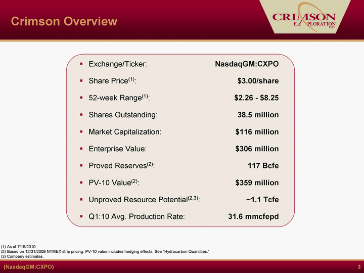
| 3 Crimson Overview Crimson Overview (1) As of 7/15/2010. (2) Based on 12/31/2009 NYMEX strip pricing. PV-10 value includes hedging effects. See "Hydrocarbon Quantities." (3) Company estimates. |
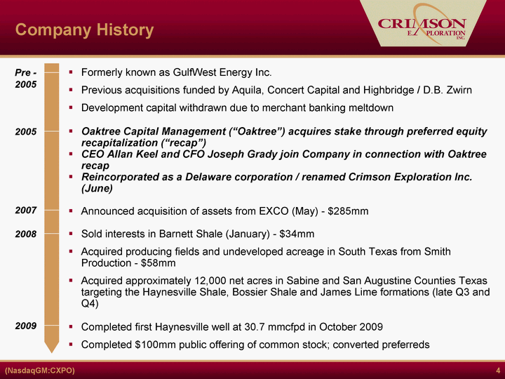
| 4 Company History Formerly known as GulfWest Energy Inc. Previous acquisitions funded by Aquila, Concert Capital and Highbridge / D.B. Zwirn Development capital withdrawn due to merchant banking meltdown Oaktree Capital Management ("Oaktree") acquires stake through preferred equity recapitalization ("recap") CEO Allan Keel and CFO Joseph Grady join Company in connection with Oaktree recap Reincorporated as a Delaware corporation / renamed Crimson Exploration Inc. (June) Announced acquisition of assets from EXCO (May) - $285mm Sold interests in Barnett Shale (January) - $34mm Acquired producing fields and undeveloped acreage in South Texas from Smith Production - $58mm Acquired approximately 12,000 net acres in Sabine and San Augustine Counties Texas targeting the Haynesville Shale, Bossier Shale and James Lime formations (late Q3 and Q4) Completed first Haynesville well at 30.7 mmcfpd in October 2009 Completed $100mm public offering of common stock; converted preferreds Pre - 2005 2005 2007 2008 2009 |

| 5 Management Team Allan D. Keel President, Chief Executive Officer and Director VP/GM Westport Resources President/COO Mariner Energy & Woodside Energy (USA) Energen E. Joseph Grady Senior Vice President and Chief Financial Officer CFO - Texas Petrochemicals Holdings, Inc. CFO - Forcenergy Inc. & Pelto Oil Company Deloitte & Touche Jay S. Mengle Senior Vice President - Engineering Shelf Asset Manager - GOM for Kerr-McGee Senior management at Norcen Explorer & Westport Resources Management and Technical Team Tracy Price Senior Vice President - Land & Business Development SVP - Land/Business Development at Houston Exploration Manager of Land/Business Development of Newfield Exploration Land Manager for Apache Corporation A. Carl Isaac Senior Vice President - Operations Exec. VP - Beryl Resources Operations management roles at Equitable Production, Westport Resources, Kerr-McGee & Enduring Resources Tommy H. Atkins Senior Vice President - Exploration General Manager - GOM for Newfield Exploration Exploration Manager for EOG Resources |
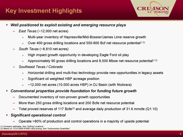
| 6 Key Investment Highlights Well positioned to exploit existing and emerging resource plays East Texas (~12,000 net acres) Multi-year inventory of Haynesville/Mid-Bossier/James Lime reserve growth Over 400 gross drilling locations and 550-800 Bcf net resource potential(1,2) South Texas (~8,810 net acres) High impact growth opportunity in developing Eagle Ford oil play Approximately 90 gross drilling locations and 8,500 Mboe net resource potential(1,2) Southeast Texas / Colorado Horizontal drilling and multi-frac technology provide new opportunities in legacy assets Significant oil weighted HBP acreage position ~12,000 net acres (10,000 acres HBP) in DJ Basin (with Niobrara) Conventional properties provide foundation for funding future growth Documented inventory of non-proven growth opportunities More than 250 gross drilling locations and 200 Bcfe net resource potential Total proved reserves of 117 Bcfe(2) and average daily production of 31.6 mmcfe (Q1:10) Significant operational control Operate >80% of production and control operations in a majority of upside potential (1) Company estimates. See "Drilling Locations." (2) Based on 12/31/2009 NYMEX strip pricing. See "Hydrocarbon Quantities." |

| 7 Reserve Summary (1) Based on 12/31/2009 NYMEX strip pricing. PV-10 value includes hedging effects. See "Hydrocarbon Quantities." (2) Reflects the conversion of barrels on a 15:1 basis. Net Present Value 10% Reserve Allocation Net Reserves |

| 8 Proven Track Record of Growth (1) 2007 - 2009 reserves per Netherland, Sewell & Associates, Inc. 2005 - 2006 reserves per Pressler Petroleum Consultants. (2) Capital expenditures include acquisitions. CAGR ~ 24% 114.6 Former SEC Rules New SEC Rules Production CAGR ~ 55% Historical Reserve Growth (1) Historical Production Growth (2) 122.6 SWLA Sale 43.1 SWLA Sale |

| 9 Existing Producing Areas Net Acreage 92,400 Proved Reserves (12/31/09) % Gas % Developed 117 Bcfe 75% 66% Q1:10 Prod. Rate 31.6 MMcfepd R/P 10 years Active Well Count 297 gross Seismic Coverage 4,200 miles 3D 2,500 miles 2D East Texas Southeast Texas South Texas Colorado and Other co TX LA Net Acreage 11,900 Proved Reserves (12/31/09) 6.3 Bcfe Q1:10 Prod. Rate 0.6 MMcfepd Active Well Count 19 gross Net Acreage 12,000 Proved Reserves (12/31/09) 8.2 Bcfe Q1:10 Prod. Rate 1.5 MMcfpd Active Well Count 1 Total Company (1) Net Acreage 15,100 Proved Reserves (12/31/09) 28.5 Bcfe Q1:10 Prod. Rate 13.5 MMcfepd Active Well Count 26 gross Net Acreage 53,500 Proved Reserves (12/31/09) 55.1 Bcfe Q1:10 Prod. Rate 9.2 Mmcfepd Active Well Count 88 gross (1) Based on 12/31/2009 NYMEX strip pricing. See "Hydrocarbon Quantities." Non-Operated Net Acreage 1,000 Proved Reserves (12/31/09) 18.7 Bcfe Q1:10 Prod. Rate 6.8 Mmcfepd Active Well Count 163 gross Resource Conventional Resource/Conventional Legend |

| 10 Conventional Asset Overview Conventional properties provide the foundation for funding future growth Key producing areas include: Southeast Texas - Yegua, Cook Mtn. South Texas - Wilcox, Frio, Vicksburg Documented inventory of non-proven growth opportunities More than 250 gross drilling locations and 200 Bcfe net resource potential(1,2) Total proved reserves of 117 Bcfe(2) and average daily production of 31.6 Mmcfe (Q1:10) Current 2010 plan includes 4 gross wells (1) Company estimates. See "Drilling Locations." (2) Based on 12/31/2009 NYMEX strip pricing. See "Hydrocarbon Quantities." |

| 11 Conventional Asset Overview (cont) TX Conventional Field Overview(1) Based on 12/31/2009 NYMEX strip pricing. See "Hydrocarbon Quantities" and "Drilling Locations." Fields: Cage Ranch, Speaks, Samano, North Bob West, Lobo, Weesatche Field: Felicia, Madisonville South Texas co Field: Wattenberg Colorado & Other LA Southeast Texas South Texas, Southeast Texas, Louisiana Non-Operated Major Producing Fields |

| 12 Overview 1P Reserves: 26 Bcfe Q1 2010 Prod. Rate: 16 Mmcfepd Target Formations: Yegua/Cook Mountain Depth: 11,000' - 16,000' Net Acreage: 15,100 acres Average WI: 75% High Yield Gas: >100 Bbls of condensate and liquid/mmcf Well Cost/EUR: $4-6 MM / 5-10 Bcfe Drilling Locations: 26 Identified locations supported by seismic amplitude having over 50 Bcfe of net resource potential (1) Seismic Coverage: 441 Sq. Mi. Liberty Co. (Felicia) Area Overview Asset Overview(1) Based on 12/31/2009 NYMEX strip pricing. See "Hydrocarbon Quantities" and "Drilling Locations." Area of Operations Locator Map Area Map |

| 13 Liberty Co. Drilling Overview Schwarz Sky Liberty Farms Unnamed Unnamed Cook Mountain Production Crimson Prospect Outline Crimson Drilling Plan Catherine Henderson #A-6 Drilled & Completed 2008 Highest Value Well in Portfolio 60% CXPO Working Interest 18 Bcfe EUR 10 Mmcfepd Production Catherine Henderson #A-7 Drilled and Completed 2010 6.2 Mmcfepd gross production Schwarz #2 Spud 5/2010 Swilley #2 S/T Sidetracked & Completed 2009 Catherine Henderson #A-8 Spud Q3 2010 |

| 14 Catherine Henderson A-7 #A-8 #A-7 #B-3 #A-6 Amplitude-Thickness Map Lower Cook Mountain 12,944'- 12,978' PUD Zone, Isolated from Upper Cook Mountain Upper Cook Mountain 12,855'- 12,895' PDP Zone CIBP @ 12,900' Catherine Henderson A-7 was completed in June 2010 at a gross rate of 6.2 Mmcfepd Rsvs Methodology: FMB/RTA/Volumetrics 1P Reserves: 11 BCF Dry Gas [58%RF] PDP: 7.6 BCF Dry Gas [40% RF] PUD: 3.4 BCF Dry Gas [18% RF] PUD Status: TBD in 2Q10 Likely PUD Remains in Lower Cook Mtn Pressure & Yield to Be Evaluated |

| 15 Cage Ranch Overview Overview 1P Reserves: 28 Bcfe Q1 2010 Prod. Rate: 3 Mmcfepd Target Formations: Frio-Vicksburg Depth: 6,500' - 10,500' Net Acreage: 14,300 Average WI: 74% Well Cost: $2 - $3 MM EUR: 1 - 3 Bcfe Drilling Locations: 31 locations Seismic Coverage: 91 sq. miles Asset Overview(1) Based on 12/31/2009 NYMEX strip pricing. See "Hydrocarbon Quantities" and "Drilling Locations." Area of Operations Locator Map Area Map |

| 16 Cage Ranch Overview (cont) Type Log Cage Ranch FRIO VICKSBURG 1.900 1.900 1.900 1.900 1.900 1.800 1.800 1.800 1.800 1.800 1.800 1.800 1.800 Potential Locations (PUD, PROB, POSS) Cage Ranch Upper Vicksburg LOMA BLANCA LWR VICKSBURG |

| 17 Speaks Overview Asset Overview(1) Based on 12/31/2009 NYMEX strip pricing. See "Hydrocarbon Quantities" and "Drilling Locations." Overview 1P Reserves: 20 Bcfe Q1 2010 Prod. Rate: 3 Mmcfepd Target Formations: Lower - Mid Wilcox Depth: 9,000' - 18,000' Net Acreage: 6,100 Average WI: 32% Well Cost: $4 - $6MM EUR: 2 - 5 Bcfe Drilling Locations: 49 locations Seismic Coverage: 163 sq. miles Area of Operations Locator Map Area Map |

| 18 Upside Potential East TX Resource (Haynesville Shale, Mid-Bossier, & James Lime) Conventional Resource Potential South TX Resource (Eagle Ford Shale) ~1.1 Tcfe of Net Unproved Resource Potential(1) (1) Company estimates. See "Hydrocarbon Quantities" and "Drilling Locations." (2) Represents upper end of estimated range of resource potential. 800 Bcfe(2) 200 Bcfe 130 Bcfe 422 drilling locations 250 drilling locations 90 drilling locations |
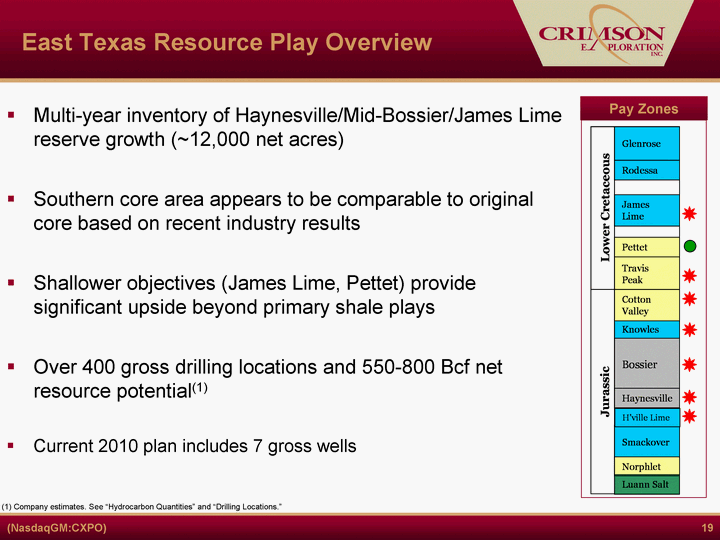
| 19 East Texas Resource Play Overview Pay Zones Multi-year inventory of Haynesville/Mid-Bossier/James Lime reserve growth (~12,000 net acres) Southern core area appears to be comparable to original core based on recent industry results Shallower objectives (James Lime, Pettet) provide significant upside beyond primary shale plays Over 400 gross drilling locations and 550-800 Bcf net resource potential(1) Current 2010 plan includes 7 gross wells (1) Company estimates. See "Hydrocarbon Quantities" and "Drilling Locations." |

| 20 Regional Haynesville Area Maximum Monthly IP Rate Per Well CXPO Leases Louisiana Texas 12,500 - 14,999 Legend Source: Drilling Info.com 6/2010 0 - 4,999 5,000 - 7,499 7,500 - 9,999 10,000 - 12,499 17,500 - 19,999 > 20,000 15,000 - 17,499 Southern Core Area Northern Core Area |
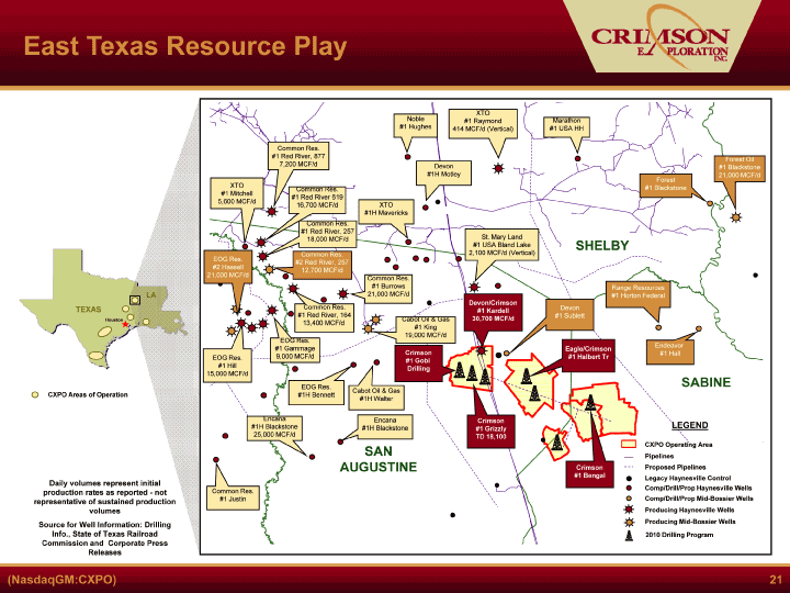
| 21 East Texas Resource Play TEXAS St. Mary Land #1 USA Bland Lake 2,100 MCF/d (Vertical) EOG Res. #1 Hill 15,000 MCF/d Common Res. #1 Red River, 164 13,400 MCF/d Common Res. #1 Red River, 877 7,200 MCF/d EOG Res. #1 Gammage 9,000 MCF/d Cabot Oil & Gas #1 King 19,000 MCF/d Common Res. #1 Burrows 21,000 MCF/d Common Res. #1 Red River 619 16,700 MCF/d Noble #1 Hughes Common Res. #1 Red River, 257 18,000 MCF/d Marathon #1 USA HH Forest Oil #1 Blackstone 21,000 MCF/d Range Resources #1 Horton Federal XTO #1 Raymond 414 MCF/d (Vertical) Common Res. #2 Red River, 257 12,700 MCF/d Devon/Crimson #1 Kardell 30,700 MCF/d SAN AUGUSTINE SABINE SHELBY XTO #1 Mitchell 5,600 MCF/d Encana #1H Blackstone 25,000 MCF/d LA Producing Mid-Bossier Wells Comp/Drill/Prop Mid-Bossier Wells Legacy Haynesville Control LEGEND Producing Haynesville Wells Houston Proposed Pipelines Pipelines CXPO Operating Area CXPO Areas of Operation Common Res. #1 Justin Daily volumes represent initial production rates as reported - not representative of sustained production volumes Source for Well Information: Drilling Info., State of Texas Railroad Commission and Corporate Press Releases EOG Res. #2 Hassell 21,000 MCF/d Devon #1 Sublett Endeavor #1 Hall Crimson #1 Grizzly TD 18,100 EOG Res. #1H Bennett Cabot Oil & Gas #1H Walter Encana #1H Blackstone XTO #1H Mavericks Devon #1H Motley Forest #1 Blackstone 2010 Drilling Program Comp/Drill/Prop Haynesville Wells Eagle/Crimson #1 Halbert Tr Crimson #1 Gobi Drilling Crimson #1 Bengal |

| 22 Haynesville Core Area Type Curve Source: 3/31/2010 DrillingInfo.com Estimated Ultimate Recovery ~6.5 BCF in 40 Years Crimson Type Curve Parameters IP: 12 MMcfpd Initial Decline: 82% Hyperbolic Exponent: 1.1 Terminal Decline: 5% Estimated Ultimate Recovery: 6.5 Bcf Triangles Denote Actual Data Solid Lines Are Match and Forecast |

| 23 East Texas Resource Play Key Statistics Note: Company estimates. See "Hydrocarbon Quantities" and "Drilling Locations." Locations are gross and assume separate wells for each pay-zone on same acreage. ~12,000 net acres ~4,000 risked acres 40% WI ~120 acre spacing Estimated well costs: $10mm ($12mm pilot holes) Estimated EUR: 6.0 - 8.0 Bcfe per well 84 drilling locations 150 - 200 Bcfe net potential Area Statistics Area Statistics Area Statistics James Lime Haynesville Shale Mid-Bossier Shale ~12,000 net acres ~8,000 risked acres 40% WI ~120 acre spacing Estimated well costs: $10mm ($12mm pilot holes) Estimated EUR: 6.0 - 8.0 Bcfe per well 168 drilling locations 300 - 400 Bcfe net potential ~12,000 net acres ~8,000 risked acres 40% WI ~120 acre spacing Estimated well costs: $3.5mm Estimated EUR: 2.0 - 4.0 Bcfe per well 170 drilling locations 100 - 200 Bcfe net potential |
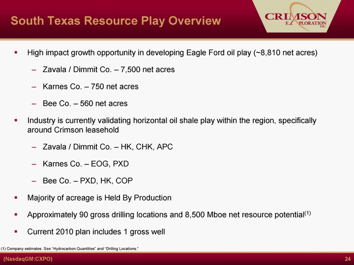
| 24 South Texas Resource Play Overview High impact growth opportunity in developing Eagle Ford oil play (~8,810 net acres) Zavala / Dimmit Co. - 7,500 net acres Karnes Co. - 750 net acres Bee Co. - 560 net acres Industry is currently validating horizontal oil shale play within the region, specifically around Crimson leasehold Zavala / Dimmit Co. - HK, CHK, APC Karnes Co. - EOG, PXD Bee Co. - PXD, HK, COP Majority of acreage is Held By Production Approximately 90 gross drilling locations and 8,500 Mboe net resource potential(1) Current 2010 plan includes 1 gross well (1) Company estimates. See "Hydrocarbon Quantities" and "Drilling Locations." |

| 25 South Texas Resource Play Note: Leasehold as of December 31, 2009. See "Drilling Locations." DRY GAS OIL GAS/CONDENSATE CRIMSON DUBOSE #1 EP PXD MUR COMMON HK : Redhawk EOG PXD COP CHK HK: Blackhawk Zavala / Dimmit County CXPO Net acres: 7,500 Drilling locations: 66 Karnes County (Fashing Field) CXPO Net acres: 750 Drilling locations: 6 Bee County CXPO Net acres: 560 Drilling locations: 18 APC SM HK TEXAS CXPO Areas of Operation Houston |

| 26 Eagle Ford Shale Key Statistics by Area Dry Gas/Gas & Cond. Corridor (40% Oil & NGLs) 560 net acres Average cost: <$400/acre 20% WI, 15% NRI Estimated well costs: $7.5mm - $10.0mm Estimated EUR: 5.0 - 6.0 Bcfe per well 18 drilling locations 15 Bcfe net potential Oil corridor (83% Oil & NGLs) 7,500 net acres HBP acreage Zavala - 95% WI, 83% NRI Dimmit - 44% WI, 33% NRI Estimated well costs: $4.0mm - $4.5mm Estimated EUR: 150 - 250 Mboe per well 66 drilling locations 6.8 Mmbbls net potential Oil corridor (88% Oil & NGLs) 750 net acres HBP acreage 50% WI, 36% NRI Estimated well costs: $5.5mm - $6.5mm Estimated EUR: 300 - 400 Mboe per well 6 drilling locations 0.7 Mmbbls net potential Area Statistics Area Statistics Area Statistics Bee County Zavala / Dimmit County Karnes County (Fashing Area) (1 Mmboe @ 15:1) Note: See "Hydrocarbon Quantities" and "Drilling Locations." |

| 27 EOG 11N 63W 17 Horizontal Permits Noble 7N 64W 5 Horizontal Permits Noble 6N 62W 6 Horizontal Permits Noble 4N 66W 1 Horizontal Permit Weld Morgan Adams Arapahoe Crimson Exploration 10,000 Acres DJ Basin, Colorado Niobrara Horizontal EOG 1500 BO/d, avg 1000 BO/d 1st 40 days Permitting >4000' Laterals Noble Active horizontal plans 2010 Unioil Porter Creek S35 12N 63W Offset to EOG Horizontal (1500 BO/d) Rocky Mtn Prod Wagner S19 1S 64W Crimson Operated Well Niobrara Base of Niobrara Codell Lateral Overview Total Net Acres: ~12,000 Total Acres HBP: 10,000 Gross Drilling Locations: 181 Target Formations: D&J Sands, Niobrara Note: See "Drilling Locations." |

| 28 TEXAS Madisonville Project Madison County, TX CXPO Areas of Operation Houston GRIMES MADISON BRAZOS Lower Cretaceous Austin Chalk Sub C'ville Woodbine Lewisville Dexter Buda Geo'town Edwards Glen Rose Rodessa Sligo Travis Peak Upper Cretaceous Approx 10,000 Acres Multiple Objectives Horizontal Applications |
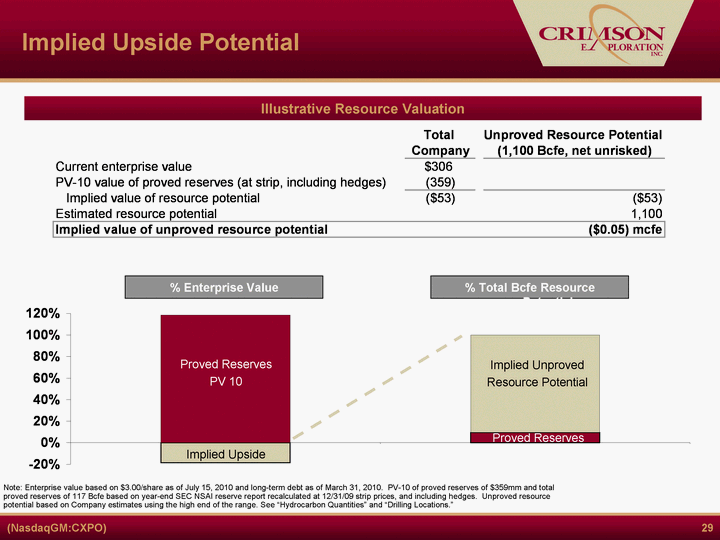
| 29 Implied Upside Potential Illustrative Resource Valuation Note: Enterprise value based on $3.00/share as of July 15, 2010 and long-term debt as of March 31, 2010. PV-10 of proved reserves of $359mm and total proved reserves of 117 Bcfe based on year-end SEC NSAI reserve report recalculated at 12/31/09 strip prices, and including hedges. Unproved resource potential based on Company estimates using the high end of the range. See "Hydrocarbon Quantities" and "Drilling Locations." Proved Reserves PV 10 Implied Unproved Resource Potential Proved Reserves Implied Upside % Enterprise Value % Total Bcfe Resource Potential |

| 30 2010 Capital Budget Total Estimated Capital Expenditures - $57mm Our 2010 capital budget is committed to developing our resource plays while continuing to exploit our high return, high cash flow conventional properties |

| 31 Capitalization Borrowing base of $100mm(1) Next redetermination: 11/1/2010 Maturity: 1/2012 Well within covenant compliance Libor + 7-800 bps 3% libor floor Maturity: 5/2012 Well within covenant compliance Capitalization Table (1) Only $95 million of the $100 million borrowing base may be utilized until the Company enters into additional hedging agreements that would add an incremental $3 million in present value to the value of its reserve base, discounted at 9% assuming the bank-price deck. |

| 32 First Lien Debt Summary First Lien Holders Agent Bank - Wells Fargo Bank Current borrowing base: $95mm(1) Next redetermination November 1, 2010 Maturity date: January 8, 2012 Covenants: Current ratio: ^ 1.0 : 1.0 Leverage ratio: ^ 3.50 : 1.0 thru 12/31/10 ^ 3.25 : 1.0 thereafter Interest coverage: ^ 2.25 : 1.0 thru 12/31/10 ^ 2.75 : 1.0 thereafter Availability as of 6/30/10 of $54mm Summary Terms (1) A maximum of $95 million of the Company's $100 million borrowing base may be utilized until the Company enters into additional hedging agreements that would add an incremental $3 million in present value to the value of its reserve base, discounted at 9% assuming the bank-price deck. |
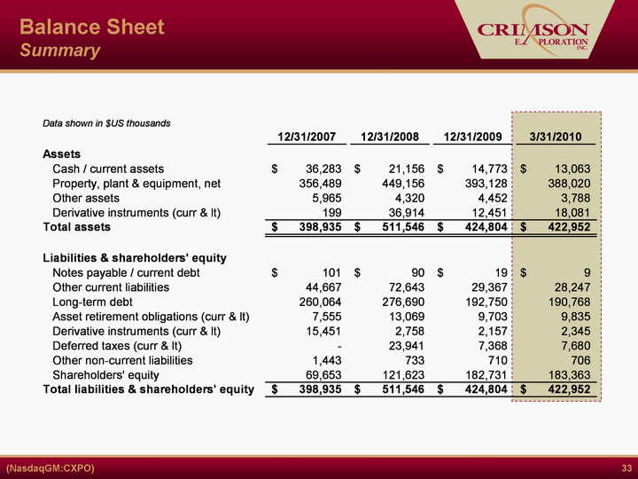
| 33 Balance Sheet Summary |
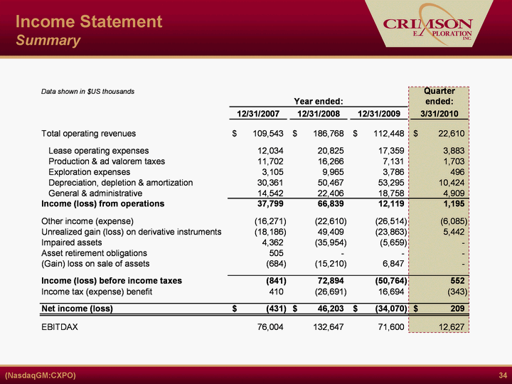
| 34 Income Statement Summary |
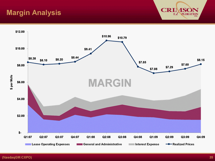
| 35 Margin Analysis MARGIN |
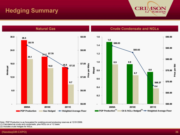
| 36 Hedging Summary Natural Gas Crude Condensate and NGLs (2) (1) Note: PDP Production is as forecasted for existing proved producing reserves at 12/31/2009. (1) Calculated as crude and condensate, plus NGLs on a 1-2 basis. (2) Includes crude hedges for NGLs. |
| 37 Investment Summary Cash flows from conventional assets to fund growth in resource plays Financial flexibility to pursue strategic plan Small, well-positioned company with compelling story Well positioned to exploit developing resource plays Significant support from major shareholder - Oaktree Capital Management |
| 38 Hydrocarbon Quantities This presentation includes certain estimates of proved reserves that have not been prepared in accordance with SEC pricing guidelines. Other estimates of hydrocarbon quantities included herein may not comport with specific definitions of reserves under SEC rules and cannot be disclosed in SEC filings. The SEC requires oil and gas companies, in their filings with the SEC, to disclose proved reserves, which are those quantities of oil and gas, which, by analysis of geoscience and engineering data, can be estimated with reasonable certainty to be economically producible-from a given date forward, from known reservoirs, and under existing economic conditions (using unweighted average 12-month first day of the month prices), operating methods, and government regulations-prior to the time at which contracts providing the right to operate expire, unless evidence indicates that renewal is reasonably certain, regardless of whether deterministic or probabilistic methods are used for the estimation. In this presentation, our proved reserves as of December 31, 2010 are based on NYMEX forward strip pricing in effect as of such date (monthly pricing through 2012 with flat pricing based on December 2012 strip thereafter), which unweighted pricing averaged $84.93 per barrel of oil and condensate and $6.22 per MMbtu of natural gas, and further adjusted for regional price differentials and transportation costs. Using Strip pricing, our proved reserves and related PV-10 as of December 31, 2009 were 116.9 Bcfe and $358.9 million, respectively. The PV-10 value of $358.9 million also included $13.2 million of PV-10 value related financial hedge agreements. SEC rules require pricing of reserves using a 12-month first day of the month index price average as of December 31, 2009, which were $57.65 per barrel of oil and condensate and $3.87 per MMBtu of natural gas, adjusted for regional price differentials and transportation costs. Using SEC pricing, our proved reserves and related PV-10 as of December 31, 2009 were 97.5 Bcfe and $176.4 million, respectively. The SEC PV-10 value of $176.4 million does not include any value for financial hedge agreements. In this presentation we have used the following terms to refer to unproved hydrocarbon quantities that the SEC rules would prohibit from inclusion in SEC filings: "Resource potential" refers to Crimson's internal estimates of hydrocarbon quantities that may be potentially discovered through exploratory drilling or recovered with additional drilling or recovery techniques. Resource potential may not constitute reserves within the meaning of the Society of Petroleum Engineer's Petroleum Resource Management System or proposed SEC rules and does not include any proved reserves. Area wide resource potential has been risked using a risk factor selected by Crimson's management. Actual quantities that may be ultimately recovered from Crimson's interests will differ substantially. Factors affecting ultimate recovery include the scope of our ongoing drilling program, which will be directly affected by the availability of capital, drilling and production costs, availability of drilling services and equipment, drilling results, lease expirations, transportation constraints, regulatory approvals and other factors; and actual drilling results, including geological and mechanical factors affecting recovery rates. Estimates of resource potential may change significantly as development of our resource plays provides additional data. "EUR", or Estimated Ultimate Recovery, refers to Crimson's internal estimates of per well hydrocarbon quantities that may be potentially recovered from a hypothetical future well completed as a producer in the area. These quantities do not necessarily constitute or represent reserves within the meaning of the Society of Petroleum Engineer's Petroleum Resource Management System or proposed SEC rules. Oil and condensate resource potential for South Texas (Eagle Ford Shale) included in this presentation is shown in Mcf equivalents based on a 15:1 Mcf/barrel conversion ratio. Liquid resource potential for other areas is converted to Mcf equivalent on 6:1 basis. |

| Drilling Locations 39 In this presentation, "potential drilling locations" represent the number of locations that we currently estimate could potentially be drilled in a particular area determined by (a) dividing the number of net acres in which we have an interest by the Company estimated well spacing requirements applicable to that area, and (b) reducing the resulting number by a risk factor based on our management's internal estimates of the risks and probabilities associated with drilling in that area. Our actual drilling activities will depend on oil and natural gas prices, the availability of capital, drilling and production costs, availability of drilling services and equipment, drilling results, lease expirations, gathering system and transportation constraints, regulatory approvals and other factors. We may not be able to drill wells on many of these locations. |